HAL Id: hal-01955949
https://hal-brgm.archives-ouvertes.fr/hal-01955949
Submitted on 14 Dec 2018HAL is a multi-disciplinary open access archive for the deposit and dissemination of sci-entific research documents, whether they are pub-lished or not. The documents may come from
L’archive ouverte pluridisciplinaire HAL, est destinée au dépôt et à la diffusion de documents scientifiques de niveau recherche, publiés ou non, émanant des établissements d’enseignement et de
Topographic and Faults Control of Hydrothermal
Circulation Along Dormant Faults in an Orogen
Audrey Taillefer, Laurent Guillou-Frottier, Roger Soliva, Fabien Magri, Simon
Lopez, Gabriel Courrioux, Romain Millot, B. Ladouche, Elisabeth Le Goff
To cite this version:
Audrey Taillefer, Laurent Guillou-Frottier, Roger Soliva, Fabien Magri, Simon Lopez, et al.. Topo-graphic and Faults Control of Hydrothermal Circulation Along Dormant Faults in an Orogen. Geo-chemistry, Geophysics, Geosystems, AGU and the Geochemical Society, 2018, 19 (12), pp.4972-4995. �10.1029/2018gc007965�. �hal-01955949�
Topographic and faults control of hydrothermal circulation along dormant
faults in an orogen.
Audrey Taillefer1, Laurent Guillou-Frottier2,3, Roger Soliva1, Fabien Magri4,5, Simon
Lopez2, Gabriel Courrioux2, Romain Millot2, Bernard Ladouche6, Elisabeth Le Goff6
1
Géosciences Montpellier, University of Montpellier, F-34095, France.
2
BRGM, F-45060 Orléans, France.
3ISTO, UMR 7327, Université d’Orléans, CNRS, BRGM, F-45071 Orléans, France. 4
Helmholtz-Zentrum für Umweltforschung GmbH – UFZ, Leipzig, Germany.
5
Freie Universität Berlin, 12249 Berlin, Germany.
6
BRGM, F-34000, Montpellier, France.
Corresponding author: Laurent Guillou-Frottier ([email protected])
Key Points:
3-D numerical models of the Têt hydrothermal system (Eastern Pyrénées, France) constrained by structural field data and hydrochemistry.
Impacts of a complex 3-D topography on the location of hot springs. Impacts of a dormant fault network and its permeability on hot spring
Abstract
Hydrothermal systems involving dormant faults within orogenic belts are rarely targeted for geothermal exploration, partly because of the complexity of the 3-D topography, the unknown permeability of the fault zones and the basement lithology, and the lack of deep-level data. This study brings together various types of surface information (spring features, geological data, topography, hydrochemistry) to explain the alignment of 29 hot springs (29-73°C) along the dormant Têt fault (Eastern Pyrénées, France). Water ion concentrations, stable water isotopes and lithium isotopic ratios indicate that (i) fluids originating from meteoric water infiltrate above an altitude of 2000 m, (ii) the rocks interacting with the fluids are similar for all the springs, and (iii) the maximum fluid temperatures at depth show similar variations along the fault and at the surface. A 3-D numerical model of the system, assembled from field structural data and from a Digital Elevation Model, explores the permeability combinations for the basement and for a three-fault network. The models indicate that for a relatively permeable basement (10-16 m2), fluids are topography-driven down to thousands of
meters (until -3700 m) before being captured by the more permeable Têt fault. Hot spring temperatures can be numerically reproduced when fault permeability is around 10-14 m², a
value slightly lower than the critical permeability for which free-convection would occur within the Têt fault. Our study shows that thermal anomalies are possible along dormant faults close to elevated topography in the core of an orogenic belt, thereby opening new perspectives for geothermal exploration.
Plain language summary
The occurrence of hot springs around the world is not easy to explain in place where there are no volcanoes to heat water in the ground, e.g., in Iceland. These hot springs are commonly encountered in the vicinity of seismic faults, which are crushed rocks acting as pipes driving water within the crust. The rocks at deep levels are naturally hot and heat water that will supply the hot springs at the surface.
In the mountain range of Pyrénées (South of France), 29 hot springs with temperatures ranging between 29 and 73°C are observed along the Têt fault. That fault does not record significant seismic activity since 5 Ma, suggesting that the pipe is likely clogged. In this study, we used chemical analyses of the hydrothermal water, field data of the topography, the hot springs, the faults, fractures and rocks, to understand the functioning of this hydrothermal system. We also reproduced the fluid circulations in a 3-D numerical model of the study area.
We show that fluids originate from the infiltration of rainwater in the highlands. The high topography controls the circulation of fluids in the crust (until -3700m), hence the hot springs location at the surface. The Têt fault is still acting as pipe from deep levels to the surface, allowing the fast ascension of the hot fluids (until 130°C for the hottest) that allows them to not become cold. These hydrothermal systems are commonly encountered within continents, and could be a great source of renewable energy to produce electricity (i.e., the geothermic energy).
1 Introduction
Province, USA (e.g. Blackwell et al., 2000; Faulds et al., 2010) or in western Anatolia Turkey (Roche et al., 2018). In these systems, meteoric waters infiltrate at high altitude, flow down into the shallow crust where they are warmed by the increasing natural temperature, and then seek pathways to quickly reach the surface before losing heat (Grasby and Hutcheon, 2001; Mckenna and Blackwell, 2004; Craw et al., 2013). Studies commonly focus on active extensional contexts (e.g., Dixie Valley, Nevada) where the normal fault offsets induce high symmetrical, cylindrical and smooth topography associated with high permeabilities both in the fault zones and in sedimentary basins, or along highly active faults where frictional heating and transport of warm rocks from depth are common (e.g. Saffer et al., 2003; Cox et al., 2015; Sutherland et al., 2017). However, it has recently been suggested that strong geothermal anomalies may also form along dormant faults (i.e., low current seismicity Mw < 4 and small cumulated offsets of < 300m during the last 10 Ma) close to high topography in the core of an orogenic belt context as defined by Moeck, 2014 (e.g. Grasby and Hutcheon, 2001; Allen et al., 2006; Ge et al., 2008; Thiebaud, 2008, Thiebaud et al., 2010; Craw et al., 2013; Taillefer et al., 2017).
Because these environments are rarely targeted for oil or mining exploration, and because of the limited access in these mountainous areas, there is a lack of deep and subsurface data (heat flow, borehole and seismic profiles, etc). Thus the challenge when studying hydrothermal systems in such contexts is to use all the shallow available data obtained from field studies (i.e., spring temperatures and locations, topography, structural measurements) as well as geochemical analyses of surface waters so as to understand the deep processes involved (e.g., Belgrano, 2015). In addition, numerical modelling of hydrothermal systems has often been applied during the last 30 years to explain hot spring occurrences, and to explore their controlling factors (Forster and Smith, 1989; Lopez and
Smith, 1995; McKenna and Blackwell, 2004; Bense et al., 2008; Guillou-Frottier et al., 2013; Magri et al., 2016; Volpi et al., 2017).
Among these factors, the topography primarily controls advective heat transfer in the crust (Forster and Smith, 1989; López and Smith, 1995, Gleeson and Manning, 2008). Firstly, isotherms in the shallow crust follow the topography above, compressed below valleys and expanded below higher relief (Braun, 2002; Glotzbach et al., 2009). However, isotherms can be disturbed by other factors such as tectonic movements, erosion and drainage divides, or lateral contrasts in lithology leading to heat refraction effects (Jaupart, 1983; Stüwe et al., 1994; Ehlers and Chapman, 1999; Stüwe and Hintermüller, 2000; Braun, 2002; Glotzbach et al., 2009). Secondly, the topography (actually, the water level elevation and its location with respect to the headwater stream, Gleeson and Manning, 2008) is the main factor responsible for meteoric fluid transfer through mountainous areas, controlling the direction of the fluid pathways and flow rates from the peaks to the valleys (Hubbert, 1940; Forster and Smith, 1988; Ge et al., 2008). The higher the topographic gradient, the deeper the fluids descend, allowing the formation of ”local” or “regional” circulations. In mountainous regions, the flow lines are likely to encounter the warmest zones beneath high reliefs than below flat areas. In such contexts, it is not clear if the topography is sufficient to drive fluids to deep enough levels to attain high temperatures, and how does the topography control hydrothermal fluid circulation and the distribution of springs.
The impact of permeability on hydrothermal systems has also been systematically identified as a critical factor in numerical models (e.g. Forster and Smith, 1988, 1989; López and Smith, 1995; McKenna and Blackwell, 2004). The presence of faults is not necessary to produce hot springs (e.g. Cox et al., 2005; Thiebaud, 2008), however, faults are permeability
heterogeneities in the crust which are known to affect hydrothermal fluid transfer and hot spring location (Faulds et al., 2010), especially at their intersections (Curewitz and Karson, 1997; Person et al., 2012; Belgrano et al., 2016). These studies are mostly related to extensional environments that involve highly permeable active faults and associated sedimentary basins, which favor free convection. Moreover, the high concentrations of hot springs in tectonically active areas can also be explained by fracture opening and breccia formation during coseismic events, which temporarily enhance fault permeability (Faulds et al., 2010; Howald et al., 2015). However, faults in orogenic contexts are often dormant, highly active faults being located towards the front of the range, at the base of the prism, and sometimes inner between major units. In addition, the cores of ranges frequently involve basement rocks uplifted during the combined effect of duplex formation and erosion (e.g., Malavieille and Konstantinovskaya, 2010). Unfortunately, the permeability values of the crystalline rocks constituting the basement are more often estimated than properly measured, the large ranges of values differing according to the scale of measurement (Brace, 1984; Clauser, 1992). In the field, the permeability values are usually low and related to the fracturing state (Brace, 1984). In addition, the evolution of permeabilities with depth is often considered as diminishing because of the effect of confinement on fracture opening (Ingebritsen and Manning, 1999; Saar and Manga, 2004; Earnest and Boutt, 2014). Such depth-dependent permeability is often used in numerical models to explain the spatial distribution of subsurface thermal anomalies (e.g. Garibaldi et al., 2010; Guillou-Frottier et al., 2013). However, this assumption is actually not sufficiently constrained by deep data, and other factors (tectonics, lithology) seem to control the evolution of permeability with depth (Ranjram et al., 2015; Taillefer, 2017). In orogenic belt contexts involving low basement permeability and dormant faults, it is unclear how hydrothermal fluid circulation might occur.
For these reasons, the hierarchisation of the factors controlling hydrothermal systems in orogenic belt environments, especially hot spring locations, merits more investigation. Because the topography of mountainous regions is controlled by faults offsets, but also by erosional processes, this hierarchisation is usually complex in three dimensions. López and Smith (1995) show, in a theoretical 3-D numerical model, that the topography along faults also influences the hydrothermal flows, and numerical simulations have never to our knowledge explored this. Most of the recent numerical studies on hydrothermal systems now involve 3-D topography, sometimes simplified as being flat or slightly sloping (Sonney and Vuataz, 2009) or cylindrical (Magri et al., 2016), but also using realistic topography derived from DEMs (Digital Elevation Models) (Craw et al., 2005; Sutherland et al., 2017; Volpi et al., 2017). However 3-D model geometry built from a complex topography and fault traces, and constrained by fieldwork, is just beginning to be implemented in numerical models (Sutherland et al., 2017).
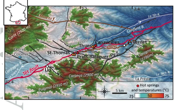
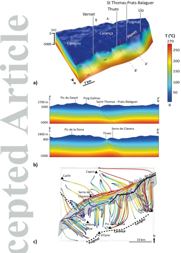
The Têt hydrothermal system (Figure 1), that is located in the eastern part of the Pyrenean range (France), lies at the interface between extensional and orogenic belt contexts. Twenty-nine hot springs grouped into four main clusters with temperatures ranging from 29 to 73°C are aligned along the 80-km-long dormant normal Têt fault (Krimissa, 1995). The regional tectonic is largely polyphase and has inherited deformations from the Hercynian and Pyrenean orogeneses, and from Neogene extension associated with the opening of the Golf of Lion (Guitard et al., 1998). The current seismicity is low (< 4 Mw), poorly localized (Souriau and Pauchet, 1998), and the stress field is weakly constrained (Taillefer, 2017). High reliefs (2910 m for the highest altitude) formed from the accumulation of the Pyrénées uplift during Eocene time and from the Têt fault’s main offset during the Oligo-Miocene period (≈ 2000
al., 2014). 2-D analysis of the topographic gradient and serial profiles performed by Taillefer et al. (2017) shows that the highest reliefs (the highest topographic gradient and the mean altitude integrated over their full width) are related to the strongest hydrothermal activity, i.e., the highest number of resurgences and the highest temperatures. The Têt fault juxtaposes basement rocks (gneiss and granite) with metasediments and localized syntectonic basins that show no spatial correlation with hot springs (Taillefer et al., 2017). Hot springs are mainly located in the Têt fault footwall, in the highly fractured crystalline rocks of the damage zone in close proximity to the cataclastic core zone (Taillefer et al. 2017). This example raises the question of how a hydrothermal system in an orogenic belt associated with faults is organized, and which processes primarily control it.
To address these various questions, this study proposes a new and inexpensive method for geothermal exploration at a large scale, in mountainous regions with sharp topography, where geophysical methods have not been operated. New hydrochemical data from the Têt hydrothermal fluids allow determining their altitudes of infiltration and their temperatures at depth. In a second section, a first 3-D numerical model of the Têt hydrothermal system is presented and explored with a parametric study of the role of fault and basement permeability. We focused on a sensitivity analysis on this parameter, allowing gain insights into the driving processes for this hydrothermal system. In other words, the general approach consists in comparing results of numerical models with spring features (temperatures, locations, and temperature at depth and infiltration altitudes given by geochemical data) to constrain the processes and unknown values of permeability. It accounts for a detailed topography based on a DEM and a fault network derived from a 3-D geological model constrained by previously acquired structural field data (Taillefer et al., 2017, Taillefer,
2017). The results enable insights into the impacts of 1) 3-D topography on fluid flow patterns, and of 2) basement and fault network permeabilities on spring temperatures.
2 Geological and hydrological setting
2.1 Geological setting
The Pyrénées result from the N-S collision between the Iberic and European plates during the Eocene (60-40 Ma, Choukroune et al., 1973; Roure et al., 1989). Duplexing and subsequent erosion have exposed basement rocks at the surface in a central part of the belt called the “Axial Zone”. The study area (Figure 1) is virtually unaffected by any deformation arising from the Pyrenean orogenesis, except for a diffuse N-S fracturing (Taillefer, 2017).
The lithologies that compose the basement in the study area are the Proterozoic to Cambrian metasediments of Canaveilles and Jujols, alternating with Ordovician gneisses of the Canigou-Carança dome, all intruded by the late-Hercynian Mont-Louis granites (Autran et al., 1986; Guitard et al., 1992, 1998). Some mylonitic Hercynian faults, e.g., the Nord-Canigou Mylonitic Overthrust (Chevauchement Mylonitique Nord-Nord-Canigou, CMNC, see Figure 1) are crosscut by brittle normal faults resulting from the Oligo-Miocene extension. During this period, a general extension in Western Europe led to the opening of the Gulf of Lion (Seranne, 1999).
In the eastern Pyrénées, the E-W structures of the Pyrenean range are crosscut by the NE-SW Têt fault. During the main period of activity, between 34 Ma to 5 Ma, with the deformation peak during early Oligocene (Maurel, 2008), this 80-km-long normal fault accumulated more than 2000 m of offset (Mauffret et al., 2001; Maurel, 2003; Delcaillau et
an elevated topography in the Têt fault footwall, divided into three moutain massifs with maximum highs around 2900 m, i.e., Puigmal, Carança and Canigou, corresponding to the three segments of the fault (see Taillefer et al., 2017); and 2) the Cerdagne and Conflent flat-lying sedimentary basins in the hanging wall, separated by the Planès topographic high (1600 m). This constitutes the watershed between the Segre and Têt rivers, which flow to the west and east, respectively. The hanging-wall topography is moderate, with the 2000-m-high Serre de Clavera range separated from the Carança range by the Têt valley.
Other NE-SW brittle faults, e.g., the Py fault that connects to the Têt fault, see Figure 1, exist in the area, however there is no information concerning their offsets, which are necessary smaller than that of the Têt fault (Taillefer, 2017). These faults, including the Têt fault, seem to have been reactivated during the upper Miocene to the lower Pliocene, but the offsets would be small (between 150 and 300 m, Carozza and Baize, 2004; Delcaillau et al., 2004) to nonexistent (Maurel et al., 2008). The recent activity of the Têt fault is still being debated (Briais et al., 1990; Philip et al., 1992; Calvet, 1999; Delcaillau et al., 2004; Calvet et al., 2014). Some authors mention evidence of dextral displacements on the Têt fault from the mid-Miocene to Quaternary (Cabrera et al., 1988), but also sinistral transtensional displacements only during the Quaternary (Carozza and Delcaillau, 2000; Delcaillau et al., 2004). Although triangular facets along the Têt and the Py faults are interpreted by Brais et al (1990) and Calvet (1999) as the manifestation of major Quaternary activity, these structures are now reinterpreted as differential erosion (Petit and Mouthereau, 2012). However, evidence of normal and even reverse metric-scale displacements within Quaternary terraces (Philip et al., 1992; Calvet, 1999; Goula et al., 1999; Calvet et al., 2014), raise questions about the recent kinematics of the Têt fault. Despite an alignment of hypocenters in the vicinity of the Têt fault (Souriau and Pauchet, 1998), the seismic activity is moderate
(magnitude 2 to 4) and focal mechanisms do not enable a precise definition of the tectonic regime (Souriau and Pauchet, 1998; Goula et al., 1999; Lacan, 2012). Moreover a synthesis of stress field data by Taillefer (2017) does not permit us to identify the recent or current tectonic regime nor its origin. The seismicity in the area is interpreted to be related to readjustment/exhumation of the Pyrenean range caused by its current erosion (Carroza and Baize, 2004; Vernant et al., 2013; Genti, 2015).
Finally, numerous NW-SE faults, potentially inherited from the Hercynian range (Autran et al., 1986; Guitard et al., 1992, 1998; Barbey et al., 2001; Padel, 2016), show brittle deformation (Taillefer, 2017). Their localisation and abutting relationships with respect to the NE-SW Neogene faults suggest that they could be syn- or even post-Pliocene (Taillefer, 2017), such as faults with similar strikes in Catalonia, 50 km south of the Têt fault (Saula et al., 1994; Tassone et al., 1994; Lewis et al., 2000).
2.2 Hydrogeological setting of the thermal springs
Twenty-nine hot springs align along the Têt fault, principally in its footwall (Figure 1, Taillefer et al., 2017). The field and geomorphological study by Taillefer et al. (2017) highlights that the hot spring locations and the intensity of the hydrothermal activity (number of springs and their temperatures) are principally linked to the topography. More precisely, simple 1-D topographic profiles perpendicular to the Têt fault suggest that springs are located at the base of the highest topographic gradients. Such 2-D results were however obtained without accounting for all the surrounding topography, whose 3-D features necessarily influence fluid circulation. Taillefer et al. (2017) also ranked the factors that seem to favor hot spring occurrence: 1) the lithology (crystalline rocks close to a contact, faulted or not,
their damage zones) that are suspected of recent activity (Taillefer, 2017); and 3) the presence of mylonites.
The twenty-nine hot springs are divided into four principal sites that may contain either one spring or several clusters (Figure 1, Taillefer et al., 2017), from the West to the East:
- Llo has one spring at 29.1°C emerging in the fractured gneiss of the Têt fault damage zone,
- The Saint-Thomas-les-bains/Prats-Balaguer site is divided into two close clusters, containing a total of eight springs with temperatures between 30.7°C and 60°C. They emerge in crystalline rocks close to a contact with metasediments. Numerous faults crosscut in the vicinity, including the WNW-ESE Prats fault.
- The Thues-les-bains/Canaveilles site contains two clusters, the first one located in the Têt fault footwall and the second in its hanging-wall. The Thues-les-bains cluster has ten springs with temperatures between 35 and 73.2°C (the hottest spring in the area), emerging in the CMNC mylonites. The three springs at Canaveilles, whose temperatures range between 52.2 and 60.1°C, emerge in gneiss close to a normal contact with metasediments.
- Vernet-les-bains counts seven springs with temperatures between 36.1 and 55.8°C, located 1 km to the south of the Têt fault. They emerge in the CMNC mylonites that juxtapose gneiss in its footwall with metasediments.
Previously, only the study by Krimissa (1995) and reports from the BRGM (French Geological Survey, Courtois et al., 2004; Ladouche et al., 2014; Petit et al., 2014) have provided geochemical data from the area. The water is alkaline, with a high pH ≈ 9, and the concentrations of Ca and Mg ions are low. The waters’ stable isotopes indicate that the hydrothermal fluid has a meteoric origin, and that infiltration areas are located above 2000 m of altitude (Krimissa, 1995, see dashed white lines in Figure 1). No variations of temperature with time have been observed (Petit et al., 2014). The 87Sr/86Sr and 36Cl/Cltotal ratios, and the
weak mineralization of the fluid would indicate that it circulates only through crystalline rocks with similar chemical signatures. Mean residence times, calculated from 14C, range
between 5,000 and 13,000 years. Finally, geothermometry indicates equilibrium temperature around 100°C (Krimissa, 1995). However, that study does not provide the precise location of the sampled hot springs, and the Llo and Prats-Balaguer sites were not sampled. Moreover, in the last decade, new methods for studying hydrothermal systems, involving the lithium isotopic ratio, have been developed (Millot and Négrel, 2007; Millot et al., 2007). For these reasons, we present below new geochemical analyses carried out on ten hot springs in the study area.
3 Geochemical constraints
3.1 Methods
At least one hot spring per cluster is sampled (see supplementary materials for the locations and features of the sampled hot springs). The hottest spring in the cluster is always sampled because it is assumed to be less mixed with surface water. Colder springs are sometimes sampled within a single cluster, in order to highlight potential fluid mixing.
The general physico-chemical features of the thermal waters are systematically measured. Measuring the ionic concentrations enables a determination of the fluid’s origin and analysis of the similarities of the fluid signatures from different springs. Using a MC-ICPMS, physico-chemical interactions between the fluids and the rocks are also explored by measuring, the lithium isotopic ratio that reveals a relationship with temperature (Millot et al., 2007).
Infiltration altitudes are calculated from the waters’ stable isotopes δ18O and δ2H, using a local δ18O gradient of 0.24‰ per100 m, established by Krimissa (1995):
𝛿2𝐻 = 7.7 × 𝛿18𝑂 + 9.9 (1)
The principal drawback of this method is the lack of knowledge of the past-climate, which may affect isotopic fractionation. In the Pyrénées, the last glaciation ended no more than 11,000 years ago (Delmas, 2009). Because infiltration of the Têt hydrothermal fluids is relatively recent (5,000 to 13,000 years, Krimissa, 1995), the climate during this period may reasonably be considered to be similar to the current one, thus introducing no bias in the altitude estimation. Moreover comparisons of the isotopic data with world (DMEM) and local (DLEM, from Négrel et al., 2007) meteoric water lines enable the fluid’s origin to be determined.
The ionic concentrations of the thermal fluid are also used to calculate various geothermometers that indicate the temperatures of equilibration between the fluid and the surrounding rocks at depth, i.e., the maximum temperature reached by the thermal fluid (White, 1965). Those applied in this study are the silica (quartz without steam lost, quartz
with steam lost, chalcedony, Fournier (1977), the Na/Li (Fouillac and Michard, 1981), and finally the Na/K (White, 1965; Ellis, 1970).
3.2 Results
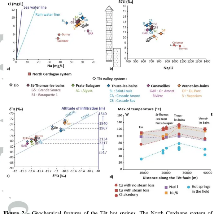
3.2.1 Fluid-rock interactions
The physico-chemical features, and the ionic concentrations of the thermal fluid (see supplementary material) are similar for all the springs (Figure 2). The only exception is the Saint-Louis spring (Thues-les-bains cluster), which exhibits anomalies of pH, dissolved O2,
and also the following ions: Ca2+, NH4+, CO32-, HCO3-, and NO3, suggesting a mixing with
surface water.
Differences of temperatures for the other sampled springs in a single cluster cannot be explained by mixing with cold water. The hydrothermal fluids are generally highly concentrated in Na ion, and poorly concentrated in Cl ion, compared to the sea and to the rain water lines (Figure 2a), thus confirming their meteoric origin. The ionic concentrations are similar for all the Têt hot springs when compared with Dorres-Colomer (another hydrothermal system in the north of the Cerdagne basin, see Figure 1), and similar for the various springs in a single cluster. The Gr. Amont Rivière spring (Canaveilles cluster) shows a lower Cl concentration and a higher Na concentration than the other springs. The low Na concentration of the Saint-Louis spring (Thues-les-bains cluster), closer to the rain water line, supports the mixing hypothesis.
The Na/Li ratio is similar for all the Têt springs (Figure 2b), and smaller than those from Dorres-Colomer. The lithium isotopic ratio δ7Li is slightly smaller for the
Vernet-les-Dorres-Colomer springs. The latter is close to the lithium isotopic ratio of a crystalline basement (Millot et al., 2010), which is consistent with the rocks with which the fluids are supposed to react (Ladouche et al., 2014). The lithium isotope ratios of the Têt springs correspond to the signatures of carbonates (Hoefs and Sywall, 1997). This particular signature will be discussed later, in section 5.3.
3.2.2 Infiltration altitude
The position of the Têt fluids in the water-stable isotope space (δ18O / δ2H, Figure 2c), surrounded by the world and local meteoric-water lines, confirms their meteoric origin. Three groups are identified:
1. Thues-les-bains (Saint-Louis excepted), Saint-Thomas-les-bains/PratsBalaguer, and Gr. Amont-Rivière (Canaveilles cluster),
2. Vernet-les-bains,
3. Llo (intermediate between these two poles).
The average infiltration altitude for the fluid is around 2100 m for all the springs, and potentially lower at Vernet-les-bains and Llo than for the other springs (see the individual altitude of infiltration for each spring in supplementary materials).
3.2.3 Fluid temperature at depth
The profiles of temperature at depth along the Têt fault (Figure 2d) calculated from the silica geothermometers mimics the profile of spring temperatures at the surface along the Têt fault. Temperatures are highest at the center of the profile (Thues-les-bains/Canaveilles,
100 to 135°C) and decrease on both sides of it. Temperatures fall between 80 and 110°C at Llo, between 95 and 120°C at Saint-Thomas-les-bains/PratsBalaguer, and between 90 and 120°C at Vernet-les-bains. The Na/K profile is close to the silica profiles, except for the lower temperature (100°C) at Saint-Thomas-les-bains/Prats-Balaguer. The Na/Li profile is flatter, with temperatures at depth around 100°C for all the springs except Vernet-les-bains (90°C).
Given that meteoric fluids infiltrate at high altitudes (at a temperature of ≈ 5-10°C) and emerge at ≈ 30-80°C, fluid pathways from the highlands to the springs must extend down to several kilometres below sea level, where ambient temperatures range between 80 and 130°C. To test this hypothesis, it is necessary to simulate fluid flow through the shallow crust from the mountain range to the permeable fault. In the following numerical modeling approach, fluid flow can be driven by topography and/or by buoyancy. Because permeability is the most variable and unknown petrophysical property, we focus our sensitivity study on this parameter. The main objective of the numerical models detailed below is to reproduce (simulate) the emergence of hot springs (location and temperature values) by varying the most uncertain parameter, i.e., the permeability of the fault zone. Similarly, the permeability of the host rocks, although qualitatively constrained by structural observations (Taillefer, 2017), also represents an additional variable. The other physical properties (rock mass density, porosity, thermal capacity, thermal conductivity, thermal expansion coefficient) do not vary greatly and do not significantly affect the hydrothermal regime in comparison to permeability.
4 Spatial distribution of thermal anomalies related to 3-D topography: numerical
modeling
This section explores the hydrothermal processes occurring in a coupled heat and fluid flow model that employs a geometry constructed from 1) a realistic topography based on a DEM, and 2) a 3-D structural model constrained by structural field data acquired at the surface. The downward extension of surface data (fault dip, intensity of fracturing) may be questioned and will be discussed later. To implement this geometric and geological model within the COMSOL MultiphysicsTM software, the Darcy law and the heat transfer equation have been
coupled in the 3-D model, through a similar numerical procedure to that used by Guillou-Frottier et al. (2013). The results of the 2-D numerical models of McKenna and Blackwell (2004) have been used as calibration models, and reproduced in COMSOL MultiphysicsTM
by Taillefer et al. (2017).
4.2 Numerical method: from 3-D geological model to 3-D physical processes
4.2.1 Governing equations and temperature-dependent parameters Faults and basement are considered to be porous and permeable media where conservation laws can be applied. The heat equation for a homogeneous and isotropic medium, as regards convective heat transfer, is:
𝜌𝑠𝐶𝑝𝑠𝜕𝑇𝜕𝑡 = 𝜆𝑠Δ𝑇 + 𝐴 − 𝜌𝑓𝐶𝑝𝑓∇⃗⃗ 𝑇. 𝑢⃗ (2)
where T (°C) is the temperature, s (kg.m-3) the medium’s density, Cps (J.kg-1K-1) its
f (kg.m-3) the fluid density and Cpf (J.kg-1.K-1) the fluid specific heat and u (m.s-1) the fluid velocity.
For porous and permeable media the Darcy law describes fluid motion driven by a pressure gradient such as:
𝑢⃗ = −𝑘𝜇 (∇⃗⃗ 𝑝 − 𝜌𝑓𝑔 ) (3)
where k (m2) is the medium’s permeability, (Pa.s) the fluid viscosity, p the pressure (Pa) and g (m.s-2) the acceleration of gravity. The fluid is assumed to be incompressible and
mass conservation requires:
∇. 𝑢⃗ = 0 (4)
The coupling between the heat transfer equation and Darcy’s law is obtained through the fluid velocity field in equations (2) and (3). Further, temperature (the other coupling variable) appears in both equations, since fluid density and fluid viscosity are temperature-dependent, as in:
𝜇(𝑇) = 2.414 10−5 . 𝑒𝑥𝑝 ( 570
𝑇+133) (5)
as defined in Rabinowicz et al. (1998), where (Pa.s) is the fluid dynamic viscosity and T (°C) the temperature, and :
where f (kg.m-3) is the fluid density.
4.2.2 Constraining data, geometry and mesh
4.2.2.1 Data and hypotheses
The structural field data used to build the 3-D geological model are presented in Taillefer et al. (2017) and Taillefer (2017). Faults have been traced using remote sensing and verified or detailed with numerous control points in the field. The fault features (dip direction, dip, organisation and constitution of the fault zones) have been analysed at the fault zone outcrops. A three months field campaign allowed collecting geological data (lithology, structural features, deformations, and at least 30 fracture measurements per outcrop) of more than 300 outcrops distributed near the faults and the hot springs but also far away in the mountain range (i.e. the infiltration areas, see sections 2.2 and 3.2.2). The results are the geological maps and cross-sections in Taillefer et al., 2017 simplified in Figure 1 as a structural scheme, the cross-sections being presented in Supporting Information, and outcrops interpretation giving the size of the damage zone (Taillefer et al., 2017). Additionally, lineaments maps and fracture features measured in the field allow respectively discussing the fracture distribution and effects according to the lithology, and consequently the permeability (Taillefer, 2017).
As detailed in section 2.1, the basement of the study area is mainly composed of crystalline rocks (see cross-sections in Supplementary Material), excepted in the western and eastern parts of the study area, where the Têt fault (respectively the CMNC) juxtaposes gneiss and metasediments. As a first approximation, these two lithologies are treated as a homogenous unit in the model. This choice is discussed in section 5.2. The two basins of
Cerdagne and Conflent (see Figure 1) have small extensions and depths and do not localize any hot springs (Taillefer et al., 2017), and are thus not considered.
In order to study only the main processes acting in the system, and not adding unnecessary uncertainties, the used geometry is here simplified by considering only the three principal faults among those previously mapped (Figure 1): the Têt, the Py, and the Prat faults (Figure 3a).
The Têt fault trace is well constrained at the surface at Llo, Thues-entre-Valls and Thues-les-bains and dips between 50 and 70° northwards. With respect to Figure 1, it is simplified in the model as a unique segment. New seismic profiles crossing the Têt fault in eastern Pyrénées (Diaz et al., 2018) fail to precisely image the Têt fault at depth..However, a potential displacement of the seismic reflector between 5 and 10 km could confirm its continuity at such depth (see their Figure 5). The Têt fault core is an alternation of fractured gneiss and cataclasite lenses. The size of the footwall damage zone (the hanging wall is hardly visible) is difficult to evaluate because vegetation quickly mask the outcrops, but is estimated around 100 and 200 m.
The Py fault, the second most important fault in the area, separates the Canigou from the Caranca massifs, connecting to the Têt fault east of Vernet-les-bains, and west of Llo. The fault zone is 300 m large and essentially cataclastic. This fault dips between 60 and 80° to the north, its NE-SW strike deviates near its centre, where it is crosscut by a NW-SE fault (the "Coum de Bassibes" fault, see Figure 1). Because of the absence of outcrop, the westward continuity of the Py fault may be discussed (Guitard et al., 1998). Its geometry is here simplified as a continuous and unique fault.
Finally, the WNW-ESE Prats fault is a cataclastic subvertical fault that connects to the Têt fault close to Saint-Thomas-les-bains (500 m) and across the Prats-Balaguer hot springs (Figure 1).
4.2.2.2 Building the geometry and mesh
We then use the GeoModellerTM software that combines topographic data (DEM) with
surface structural data (faults, stratigraphic contacts) to create a 3-D geological model consistent with the structural geology principles (constant strata thickness, overlaps, cross-cutting relationships; e.g., Calcagno et al., 2008). The GeoModellerTM uses field structural
measurements (dip and dip-direction) in various control points, together with the fault traces obtained from surface mapping (Figure 1) to extrapolate them at depth, and then to build the 3-D geological model of the study area (Figure 3a). Faults are modelled as surfaces in a volume that represents the basement.
A thickness of 300 m is assigned to the faults, corresponding to an average size of fault zone, i.e. the volume where the permeability will be tested independently of the basement.
The upper surface of the model corresponds to the realistic topography of a 30 m DEM resolution from the USGS (Figure 3b). The highest elevation of the geometry is the highest peak in the area (the Puigmal: 2913 m). The base of the model is fixed at a depth of 5,000 m. The area covered by the model is 43 km long (E-W) and 32 km wide (N-S), and includes all the hot springs. Without any information about the level of the water table below the mountain range, its location is approximated as being the topographic surface. This approximation is often valid for crystalline rocks aquifers in high mountain ranges (Tiedeman
et al., 1998; Bossong et al., 2003; Caine et al., 2006) where the water table location, close below the surface, poorly influences the regional flows (Gleeson and Manning, 2008).
To avoid errors and overlong computational time, a mesh convergence study was performed by refining the mesh successively until a similar solution to the previous one (within a difference of about 1°C) was found. It turned out that stable solutions were obtained for about 500,000 elements. A polygonal mesh grid of 503,976 elements has accordingly been built over the entire geometry (Figure 3b). The mesh is refined around the topographic complexities, the fault planes and fault intersections. The mean and smallest element sizes are respectively 827 m and 6 m in the main volume, and 609 m and 8 m around the faults.
4.2.3 Model parameters and simulations
The fault and basement permeabilities excepted, fluid and rock properties are common to all simulations (Table 1). Three kinds of simulation were computed, using different geometry settings (Table 2):
- Simulation 1: Homogeneous basement without any faults,
- Simulation 2: Homogeneous basement involving the Têt fault only,
- Simulation 3: Homogeneous basement involving the Têt, Py and Prats faults.
Among all the petrophysical properties that have to be implemented in the model, permeability is by far the most poorly-known property, with a range of possible values spanning several orders of magnitude. In this study, the selected permeability values are consistent with the range of crystalline rock permeability values encountered in the literature
current state of knowledge concerning the permeability of crystalline rocks, and Table 2 for the permeability combinations used in the simulations). Although lateral lithological variations have been observed in the field (see Section 2.1), the permeability of the lithologies encountered in the study area (metasediments, granite, gneiss) is mainly linked to the fracture network. Thus, the basement is here considered to be a single homogeneous unit and is tested for two permeability values: kb = 10-17 m2 (impermeable) and kb = 10-16 m2 (fairly permeable, that is consistent with the fracture density and opening study by Taillefer, 2017). The Têt fault damage zone is thought to have enhanced the basement permeability (Taillefer et al., 2017). However, because the recent fault activity (see Section 2.1) and fracture sealing in the damage zone are poorly constrained, a large range of permeability was tested (Table 2) consistently with values encountered in the literature for faults in equivalent basement rocks (Evans et al., 1997; Sonney et Vuataz, 2009). The Py and Prats faults being of smaller importance than the Têt fault (Taillefer, 2017), an intermediate permeability of kfPy = kfPr= 5.10-15 m2 is assigned in the last simulation.
4.2.4 Boundary and initial conditions
4.2.4.1 Flow conditions
An altitude-dependent atmospheric pressure Patm(z), from the International Civil Aviation Organization Standard Atmosphere, is imposed at the topographic surface (Figure 3c):
𝑃𝑎𝑡𝑚(𝑧) = 𝑃0 × (1 −0.006𝑧288.15) 5.255
where P0 = 105 Pa is the atmospheric pressure at sea level and were z (m) is the altitude. Below the surface topography, a hydrostatic pressure gradient ρ.g is added to P0. No flow is allowed through the lateral limits of the model.
4.2.2.2 Thermal conditions
Because of the lack of regional deep-level data, a constant heat flow q0 = 0.09 W/m2, consistent with the heat flow map of France by Lucazeau and Vasseur (1989), is imposed at the base of the model. The lateral limits of the model are thermally insulated.
In order to allow for temperature variations at the surface (cold areas at high altitudes but also warm zones where hot springs emerge), a mixed thermal boundary condition like that used in Magri et al. (2016) is applied to the topographic surface:
𝑄 = ℎ(𝑇0− 𝑇) (8)
where Q (W.m-2) is the surface heat flow, h (W. m-2.K-1) a coefficient of heat transfer
and T0 (°C) the reference temperature at the surface (chosen to be 10°C).
In order to impose a realistic thermal boundary condition, a sensitivity analysis of the heat transfer coefficient h was performed. The condition applied to the topographic surface needs to satisfy: 1) a realistic temperature at the surface (5-10°C in the study area), and 2) potential convective flows allowing hot fluid emergence. The h value has therefore been calibrated so as to combine realistic temperatures for (i) the fluid infiltrated at the model surface, and (ii) the hot fluids that rise up to the model surface (calibration details are available in the Supplementary Materials).
To obtain consistent temperatures at the surface (between 5 and 10°C) while emergence temperatures may reach 70°C, the optimum h value appears to range between 0.017 and 0.025 W.m-2.K-1. Lower values cause all the basins and valleys to reach 30°C, a
value which is not observed in the field. Higher values do not permit thermal convection to affect the surface temperature. Accordingly, h is assigned the value of 0.02 W.m-2.K-1, which
is a good intermediate figure allowing convection to produce positive thermal anomalies at the surface (up to 70°C) without inducing unrealistic temperatures in the valleys and basins. Using this value, the few areas at high altitude (above 2000 m) exhibit low temperatures (5-7°C) while all other areas show surface temperature of 10 +/- 2 °C.
The initial conditions for the model are a hydrostatic pressure and a purely conductive thermal state, from which a steady-state is computed. Transient evolution of permeability, topography, or pressure, will be discussed in section 5.
4.3 Results
4.3.1 Preliminary study of the thermal regime: the critical Rayleigh number
The Rayleigh number (Ra) enables determination of the thermal regime within the model, and in particular the critical permeability value from which free convection is likely to start (Magri et al., 2016). For an infinitely long homogeneous porous medium (Lapwood, 1948), Ra is defined as:
𝑅𝑎 = 𝐾 𝐿 𝛼 ∆𝑇𝐷
𝜆 (9)
k = K (𝜌𝜇
𝑓𝑔) (10)
L (m) is the thickness of the medium in which the flow takes place, (K-1) the
coefficient of thermal expansion and T (°C) the difference in temperature between the upper and lower limits of the medium. The tensor of thermodispersion D is defined by:
𝐷𝜆 = 𝜙 𝜆𝑓𝜌+(1−𝜙)𝜆𝑠
𝑓 𝐶𝑝𝑓 (11)
where is the porosity, f (kg.m-3) the fluid density, Cpf (J.kg-1.K-1) the thermal capacity of the fluid, and f and s the fluid and solid thermal conductivity, respectively. The value of f is taken at the minimum temperature (here 10°C). Given (i) a basement thickness between the infiltration area’s altitude (+2000 m) and the model’s base (-5000 m) of 7000 m, (ii) a basement permeability kb of 10−16 m2, (iii) a temperature difference of 270°C between
the top and the base of the model, and (iv) fluid and rocks properties as indicated in Table 1, the computed Rayleigh number is Ra ~ 0.34.
This value is much smaller than 42
, the critical Rayleigh number Rac from which
free convection is likely to start for an infinitely long homogeneous porous medium. This means that the thermal regime in the basement is probably not driven by buoyancy flow but by topography (forced convection only). However, for a finite medium including faults, the critical Rayleigh number depends on the faults’ dimensions, and can be expressed by the ratio between the fault width and height.
Analytical and numerical simulations by Malkovsky and Magri (2016) show that, given the geothermal gradient in the study area, the critical fault permeability kfc at which
convection is likely to start within the fault is calculated by assuming Rcf/4 (e.g., Figure 4 in Malkovsky and Magri, 2016). For a fault width d =300 m, and a fault altitude in the model surface around 1000 m (which corresponds to a fault height of H = 6000 m), Rcf/4 = 68. The inferred critical permeability for which thermal convection may occur in the fault is thus (using this value of 68 and Equations 9 and 10):
𝑘𝑓𝑐 =68×[(0.1×0.6+0.9∗2.5)/(1000×4180)]107×6000×10−4×270 ~ 2 10-14 m² (12)
Consequently, in the model computed here, the free convection within the fault is likely to start at a fault permeability higher than 2.10-14 m2.
4.3.2 Single-fault model
4.3.2.1 Thermal anomalies at the surface
Small, cold thermal anomalies appear at the surface along the Têt valley when the permeability is similar in the basement and in the Têt fault (10-16 m2 everywhere, Figure 4a).
In this case, only two narrow thermal anomalies (around 25°C) are aligned along the Têt fault, between St-Thomas/PratsBalaguer and Thues, and east of Thues/Canaveilles. No thermal anomaly is visible at Llo or at Vernet.
For a basement permeability kb = 10-16 m2 and a Têt fault permeability kfT = 10-14 m2
(Figure 4b), four positive thermal anomalies are aligned along the Têt fault, corresponding to the observed clusters. The largest thermal anomaly, located between Saint-Thomas/Prats-Balaguer and Thues/Canaveilles, is also the hottest (70°C at Thues). The other thermal anomalies at Llo, east of Canaveilles, west of Vernet, and at Vernet, are smaller and temperatures reach 50°C. Temperatures of the thermal anomalies at Thues-les-bains and
Saint-Thomas vary as a function of the basement and the Têt fault permeabilities (Figure 4c). For low permeability values within the Têt fault (kfT < 10-15 m2), the temperatures at Thues
and Saint-Thomas are around 20°C for basement permeability kb = 10-17 m2, and 30°C for kb =
10-16 m2. For good permeability values within the Têt fault (kfT > 10-15 m2), the higher the Têt
fault permeabilities, the higher the temperatures at Thues. Finally, for a high permeability within the Têt fault (kfT = 10-14 m2), the temperature at Thues is the highest for kb =10-16 m2,
reaching 73°C (the maximum observed hot spring temperature). The trend is different or even reversed for Saint-Thomas: temperatures are stable for a basement permeability of kb =10-17
m2, and decrease with increasing Têt fault permeability for kb =10-16 m2.
The Têt fault and basement permeabilities induce different patterns of thermal anomalies along the Têt fault (Figure 4d). The same peaks of thermal anomaly, with different amplitudes, are observed for all the cases studied. For the case in which the fault has the same permeability as the basement (kb = kfT =10-16 m2 ), the temperature along the fault at the surface ranges between 15 and 28°C, with the maximum temperature at the fault’s center (blue curve in Figure 4d). Making the Têt fault quite permeable (kfT = 10-15 - 10-14 m2) results
in doubling or tripling the amplitude of the peak temperatures in the case of a basement permeability of 10-17 m2 or 10-16 m2, respectively. Observed hot spring temperatures are
reproduced at Llo and Thues-les-bains/Canaveilles, and approximately at Vernet for kb = 10
-16
m2 and kfT =10-14 m2 (light green curve in Figure 4d). However, the hot spring temperatures at Saint-Thomas-les-bains/Prats-Balaguer are not reproduced. Finally, it is interesting to observe that the temperatures between the positive thermal anomalies are lower for a permeable fault than for a sealed one.
4.3.2.2 Thermal anomalies at depth
The location of thermal anomalies at the surface arises from the distribution of thermal anomalies at depth along the fault plane (Figure 5a). Negative thermal anomalies (infiltration areas), associated with moderate downward Darcy velocities, alternate with positive ones (emergences) associated with high upward Darcy velocities, which mostly correspond to the location of the hot spring sites. The highest Darcy velocities (1.7x10⁻⁸ m.s
-1
) and temperatures are located at Thues (Figure 4d). A large infiltration area along the Têt fault corresponds to the Planes topographic-high (top right of Figure 5a). Darcy velocity vectors diverge eastward and westward from this area, inducing a negative thermal anomaly affecting Saint-Thomas/Prats-Balaguer.
Thus depending on the location, the along-fault flows have different effects on the temperature in the surrounding basement (Figure 5b, see Supplementary Materials for the cross-sections at Llo and Vernet-les-bains). Around the Têt fault, isotherms are depressed at Saint-Thomas/Prats-Balaguer whereas they are elevated at Thues. The wavelengths of the thermal anomaly are ≈ 500 m near the surface and ≈ 4 km at -4000 m. The amplitude of the thermal anomaly decreases with depth.
Flow lines within the model show the origin and pathway of the fluids in relation to the thermal anomalies on surface (Figure 5c). The features of the flow lines related to each thermal anomaly are summarized in Table 3. A large majority of the flow lines contributing to these thermal anomalies come from the mountain ranges in the Têt fault footwall, descend inside the model until they reach a certain depth (sometimes the bottom of the model, see Table 3) where the fluid is heated to 210°C. The deeper the fluid descends, the higher its
temperature. Fluids are directed towards the Têt valley and caught by the Têt fault, which brings them towards the surface, thus creating thermal anomalies, i.e., the hot springs.
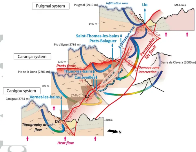
The Planes topographic-high (see Figure 1 and Figure 5 a, c) is a separation line for the fluids that infiltrate into the Têt fault. Along the Têt fault at Saint-Thomas/Prats-Balaguer, the emerging flow lines do not descend deep enough to generate hot fluids. However, some flow lines infiltrated at Planes along the Têt fault, which do descend deep enough to heat the fluids (-2000 m), emerge at Thues/Canaveilles. These waters contribute to the high thermal anomalies observed there.
Finally, the flow lines coming from the Têt fault’s hanging-wall are caught at depth by the Têt fault and flow eastward at a deep level, without reaching the surface. The only exceptions are the flow lines coming from the Serre de Clavera, the highlands at the north of the valley above Saint-Thomas/Prats-Balaguer, which descend far enough to make an additional positive contribution to the Thues/Canaveilles thermal anomalies (-1950 m, see Table 3).
4.3.3 Multi-fault model (Têt, Py and Prats)
In a permeable multi-fault model (kfT = kfPy = kfPr =5.10-15 m2, Figure 6), fluid
circulations also take place along the fault planes, affecting the isotherm distribution (Figure 6a). High-downward Darcy velocities allow infiltration of cold fluids within the mountain ranges, especially in the first kilometer. The Py fault allows considerable fluid infiltration, thus preventing the formation of positive thermal anomalies at the surface.
High upward Darcy velocities are found along the Prats fault, at its intersection with the Py and Têt faults, and at its center where there is a topographic depression. At the intersection between the Py and the Prats faults and at the topographic depression, the fluid is too cold to create a hot emergence. However, isotherms are elevated at the intersection between the Prats and Têt faults. Compared with the single-fault model (kfPr = kb =10-16 m2,
Simulation 2, Figure 6b), attributing a high permeability to the Prats fault (kfPr = 5.10-15 m2)
induces an upwelling of hot fluids originating from infiltration along the Prats fault, and the creation of a positive thermal anomaly at Saint-Thomas/Prats-Balaguer (Figure 6c). It enables duplication of the hot spring temperatures of Saint-Thomas/Prats-Balaguer, unlike the single-fault model (Figure 4d).
5 Discussion
5.1 Relationship between the topography and the distribution of thermal anomalies along the Têt fault
Numerical results suggest that topography (i.e. an elevated water table) is the key factor controlling the fluid pathways and the hot spring distribution in the Têt hydrothermal system. The location of the positive thermal anomalies at the surface of the numerical model (Figure 7a) confirms the field study of Taillefer et al. (2017), which showed that the most intense hydrothermal activity (highest temperature and hot spring number) is related to the highest topography in the Têt fault’s footwall. Moreover, the elevations of the infiltration areas in the models correspond to those calculated from water-stable isotopes. Since the topographic gradient controls the depth of fluid infiltration (Figure 5c), it also controls the maximum temperatures reached by the fluids at depth, as indicated by numerical models (Table 3) and confirmed by geothermometry (Figure 7b).
However, the impact of the topographic gradient along the fault on the fluid pathways, although theoretically demonstrated by López and Smith (1995), had never been highlighted for hydrothermal system, previous models having involved a more symmetrical or “cylindrical” topography (e.g. Mckenna and Blackwell, 2004; Magri et al., 2016) or a complex topography without faults (e.g. Craw et al., 2005; Ge et al., 2008; Volpi et al., 2017). Thus, the Planes topographic-high, separating the Têt valley from the Cerdagne basin, acts as a watershed for groundwater infiltrated along the permeable Têt fault (Figure 7c). The resulting alternation of infiltration and resurgence areas controls the distribution of temperatures at all depths along the Têt fault (Figure 7a and d), including the surface. Moreover, the Py fault is exclusively an infiltration structure despite its similarities with the Têt fault (Figure 6a). Further, fluids that flow at depth toward the east along the fault plane (Figure 5c) will never reach the surface because of the regional topographic gradient between the Cerdagne and de Rousillon basins. This suggests that the fault’s ability to localize hot springs is also controlled by the fault plane’s location with respect to the surrounding topography. Hence, it is crucial to examine both the topography’s complexities in 3-D and the fault system patterns to understand the full hydrothermal system, as recently demonstrated for other examples (e.g., Sutherland et al., 2017; Volpi et al., 2017). The location of the water table could be even more critical. If it actually does not correspond to the topography (our hypothesis, see section 4.2.2.2), this could influence the part of the discharge driven by the topography. However, if the water table was positioned 200 - 300 m below the surface, the difference of hydrostatic pressure would be low compared to that within the 3 km layer through which the fluid circulates. Furthermore, the pressure gradients would not be affected. Considering the residence times of the water, the reservoir size should be huge. Thus, the
overestimated quantity of water is likely low compared to the volume of stored fluids, and would probably not influence the final discharge.
The major portion of the Têt valley’s topography was acquired during the combined uplifts of the Eocene Pyrenean orogenesis and the Oligo-Miocene extension (≈ 2000 m, Mauffret et al., 2001; Maurel, 2003; Delcaillau et al., 2004; Maurel et al., 2008). Naturally, the relief would have been modified by erosion over the last 5 Ma. However, the 55 m/Ma maximum erosion rates evaluated in the region (Calvet et al., 2015; Sartegou et al., 2018) represent a maximum incision of 350 m of the Têt valley. Moreover the ice cover during the last glaciations was quite limited in the study area (Delmas et al., 2009; Calvet et al., 2014) and has had little effect on the topography (Jarman et al., 2014). Thus it seems reasonable to assume that the currently observed topography used in numerical models (Section 4.1.2) approximates the early Pliocene one, and that the potential error does not affect the highest topographic gradients involved in the topography-driven transport of hydrothermal fluids. However, the temporal evolution of the permeability with respect to the recent evolution of tectonic stresses (unconstrained and debated in the study area, see Section 2.1) may be more critical, as discussed below.
5.2 Fault and basement permeabilities
2-D numerical models of the Têt hydrothermal system constructed in a previous study (Taillefer et al., 2017) demonstrated the strong impact of the Têt fault’s permeability on hydrothermal circulations, as confirmed by the sensitivity study in Section 4.3. The case of a topography-driven hydrothermal system with no permeable fault (or a sealed one, e.g., Simulation 1), is likely to produce weak thermal anomalies (maximum 30°C) at the valley bottom (Figure 4a), i.e., where they are also observed for the highest permeability
simulations. Thus, the topography appears primarily to control hot spring location and temperature, while the permeability acts secondarily to adjust the temperature. The strong thermal anomalies at the surface result from (i) fluid flow in the basement caught by the Têt fault, and (ii) fluid flow infiltrated along the Têt fault. For a fault permeability increase of one order of magnitude, the temperature of positive anomalies may double, while the effect is half as big for the same increment of basement permeability (Figures 4c and 4d).
The alternation of positive and negative thermal anomalies at depth along the faults is described for hydrothermal systems involving free convection (e.g., Magri et al., 2015, 2016). In our more relevant models (Simulation 3), the highest permeability used to the Têt fault is close to the critical permeability kfc ≈ 2.10−14 m2 for which free convection is likely to start
(see Section 4.2.1). This raises the question of the possibility of developing free convection in the Têt hydrothermal system. However, the all range of permeability values used in the models is not completely realistic. Indeed, permeability probably decreases with depth, both in the basement and in the fault (e.g., Stober and Bucher, 2015, Taillefer, 2017). Consequently, depending on the Rayleigh number, this would decrease the elevation at which convection is likely to occur. The critical permeability would thus have to increase up to an unrealistically high value for this kind of lithology, unless dynamic (time-dependent) permeability is accounted for (Ingebritsen and Gleeson, 2015).
The sensitivity study carried out in this paper may be used to evaluate the effective permeability values that are impossible to measure at this scale. Our results suggest that the Têt fault is still permeable for a fault in crystalline rocks (Bense et al., 2013), although it has been dormant since the Mio-Pliocene (Goula et al., 1999). Moreover the role of the Prats fault, which is required to reproduce the Saint-Thomas thermal activity (Simulation 3, Figure
6), suggests that the NW-SE fault network is also probably permeable. However, fracture networks such as fault damage zones may be quickly sealed by hydrothermal alteration deposits (several thousand to a few million years, Lowell et al., 1993; Renard et al., 2000) without any tectonic activity (Faulds et al., 2010; Howald et al., 2015; Stober and Bucher, 2015). Hence, the recent and current low tectonic activity in the Eastern Pyrénées (see Section 2.1), together with fluid overpressure and favourably oriented stress field, or current seismicity, may suffice to maintain an efficient permeability in the fault entire network. In addition, our study highlights the importance of permeability variations along the Têt fault for the location and temperature of hot springs: i) enhanced permeability at fault intersections as demonstrated by many previous authors (Faulds et al., 2010; Person et al., 2012; Belgrano et al., 2016); ii) the partial sealing of the Têt fault damage zone at Thues-entre-Valls (Taillefer, 2017), which could explain the lack of hot springs at places where numerical models predict a strong positive anomaly (Figure 4d, and see Howald et al., 2015). This suggests that permeability has not been constant throughout the faults (along strike and in depth) over the last 5 Ma. Transient effects on the permeability (sealing by hydrothermal alteration minerals versus tectonic activity such as pressure variations) should be explored in future simulations.
Similarly, our simplified model does not take several considerations into account :
(i) The basement is considered as a homogenous unit of crystalline rocks, without considering permeability variations with lithology. Fluids transfer is here studied at a regional scale, in a range of permeability consistent with the measurements referenced in Clauser (1992) for this scale. Actually, the basement in the area is composed of crystalline rocks and metasediments. In the literature, permeability of these two kinds of rock is sometimes not differentiated because mainly related to fracturing (Freeze and Cherry, 1979; Gleeson et al.,
2011; Ranjram et al., 2015), but simultaneously some data seems to indicate that the permeability range for metasediments is smaller than crystalline rocks (10-20 – 10-17 m2 vs10
-18
– 10-13 m2,respectively, Brace, 1980, Taillefer, 2017). Further, cross-sections of the study
area (from Taillefer et al., 2017, see Supporting Information) reveal that metasediments constitute only a small part of the basement in the Têt fault footwall, from where most of the hydrothermal fluids originate. However, they could act as a layer-seal for driving fluids from depth to the surface and localizing hot spring as suggested by Taillefer et al., 2017 and Taillefer, 2017. In that sense, testing permeability contrasts related to lateral and vertical variations of the lithology in a future numerical model would be essential. The importance of the Neogene basins is more controversial: on the one hand the constitutive lithologies are porous and often related to free convection in extensive hydrothermal system (Moeck, 2014); on the other hand, their size are really reduced in the study area and they do not localize hot springs (Taillefer et al., 2017). As a first approximation, considering the basement in the model as a homogenous unit allows catching the general processes acting in this system.
(ii) The permeability is not considered as diminishing with depth. Even though most of the authors mention a decrease of the permeability with depth (Ingebritsen and Manning, 1999; Saar and Manga, 2004; Earnest and Boutt, 2014), mainly related to the increase of the confining pressure, this relation is not clearly demonstrated for crystalline and metamorphic rocks (Brace, 1980, 1984; Stober and Bucher, 2015; Ranjram et al., 2015), especially for depths greater than 500 m where data are rare and cover permeability ranges between 10-20
and 10-14 m2. Without more information about rock permeability and its evolution with depth
in the study area, testing a homogenous permeability in the model allows identifying the depths where the basement is necessarily still permeable to reproduce thermal anomalies at
the surface. Taillefer (2017) proposes, based on elastic models applied to fracture apertures in the study area, a permeability decrease that would be tested in future simulations.
(iii) The transient effects of glaciations on the hydrothermal system are not taken into account. The effects of glaciation on the groundwater recharge is still an investigated topic, because numerous processes related to the geological and glacial contexts are involved, but data sets are currently insufficient (Neuzil, 2012). Numerical studies of the transitional effects of the last glaciation on Alps hydrothermal systems use the assumption that glaciations block the groundwater recharge and that a deglaciation is necessary to reproduce the currently observed temperatures (Maréchal et al., 1999; Thiebaud, 2008; Thiebaud et al., 2010; Volpi et al., 2017), which is not our case. Further, some other studies indicate that glaciers do not suspend fluid infiltrations, except maybe if impermeable permafrost develops (Ge et al., 2008; Lemieux et al., 2008). Anyway, as discussed in the section 5.1, the ice cover during the last glaciation did not extend over the entire infiltration area (Delmas et al., 2009; Calvet et al., 2014), which at worst had blocked only a small part of the inflow probably negligible at the reservoir scale (considering the residence time). However, this could motivate a comparison of the transient effects of glaciation between Alpine and Pyrenean hydrothermal systems.
Future complex models should also incorporate other mapped secondary faults in the area (Figure 1), and test various geometries at depth as long as seismic profiles fail to precisely image the normal fault network in the basement (Diaz et al., 2018). Using the new light tomography methods adapted to sharp topography could be useful to improve the sub-surface fault geometries.