HAL Id: halshs-01145658
https://halshs.archives-ouvertes.fr/halshs-01145658
Submitted on 1 Sep 2016HAL is a multi-disciplinary open access archive for the deposit and dissemination of sci-entific research documents, whether they are pub-lished or not. The documents may come from teaching and research institutions in France or abroad, or from public or private research centers.
L’archive ouverte pluridisciplinaire HAL, est destinée au dépôt et à la diffusion de documents scientifiques de niveau recherche, publiés ou non, émanant des établissements d’enseignement et de recherche français ou étrangers, des laboratoires publics ou privés.
Global maritime connectivity: a long-term perspective
César Ducruet
To cite this version:
César Ducruet. Global maritime connectivity: a long-term perspec-tive. Port Technology International, Maritime Information Services, 2015, 65, http://www.porttechnology.org/images/uploads/technical_papers/034-036.pdf. �halshs-01145658�
Global maritime connectivity: a long-term perspective
Pre-final version of the paper published in Port Technology International No. 65, 2015Dr César Ducruet, Research Fellow, CNRS Géographie-Cités Research Unit, Paris, France
Macroscopic patterns of global maritime flows
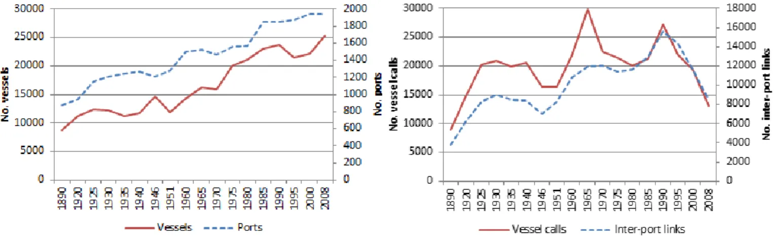
Global trade growth has inevitably resulted in a regular increase in the number of ports and vessels since the late nineteenth century (Figure 1a). Yet the number of inter-port links and vessel calls have fluctuated much more widely (Figure 1b). Over the last 125 years, three peaks of global maritime activity have coincided with periods of relative economic prosperity and great technological innovations: steam shipping (1890-1925), diesel engines (1960-1970) and massive containerships (1985-present). The reduction of links and calls since 1990 underlines the effects of network rationalisation associated with growing vessel sizes, further sailing distances, and an increased concentration of services on fewer ports.
Figure 1: Evolution of global maritime traffic, 1890-2008
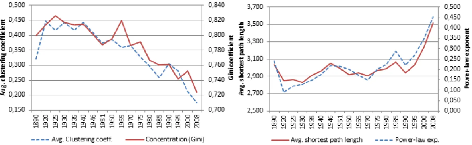
The latter trend is confirmed by the evolution of network indices (Figure 2). The average shortest path length has increased relatively fast in recent times which implies a lesser ease of circulation across the network. A similar evolution is illustrated by the power-law exponent, as fewer ports concentrate a larger number of links over time. In parallel, the regular decline of the Gini index and clustering coefficients suggest an increasing centralisation of the shipping network around large hubs, which are becoming more numerous. The morphology of the global maritime network is increasingly a star-shaped structure whereby a few large hubs dominate a majority of peripheral nodes, as in a typical hub-and-spoke system centered upon large and multifunctional distribution platforms. The spread of containerisation has also accelerated rather than disrupted ongoing trends of network evolution. This suggests a strong path and place-dependency of technological change because already established ports have a higher probability to sustain their dominance and to grow than other ports.
Figure 2. Evolution of global maritime connectivity, 1890-2008
Regional shifts in the global port hierarchy
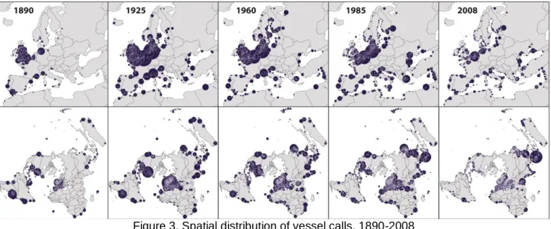
Important changes are felt geographically (Figure 3). Among world regions, there is a clear shift from Euro/Atlantic to Asia/Pacific dominance. Asia exhibited growth from 6% to 38% of global vessel calls in the 1890 – 2008 period, reaching the highest number of vessel calls in 1995. In 2008, Europe goes back to the initial share of world calls it had back in 1890 (about 35%) after a period of overwhelming dominance marked by strong traffic fluctuations, which lasted until 1970 and was followed by stagnation and rapid decline.
In comparison, Africa, Oceania and Latin America are relatively stable, whereas North America shifted from 17% in 1890 to 6% in 2008. In parallel, maritime connectivity has increasingly been intra-continental, from 63% to 87% on average over the period. This is due to growing regional integration but also to increasing transshipment within regions via intermediate hubs. More than 90% of European and Asian flows were intra-continental by 2008, and this is largely due to the centralisation upon large hubs internally. The rapid decline of North American connectivity is explained by the growing size of ships elsewhere, but also by the shift of traffic towards external, Caribbean hub ports, as well as, until the Panama Canal is expanded, the dominance of US West Coast ports for Asian imports.
Comparing port growth trajectories
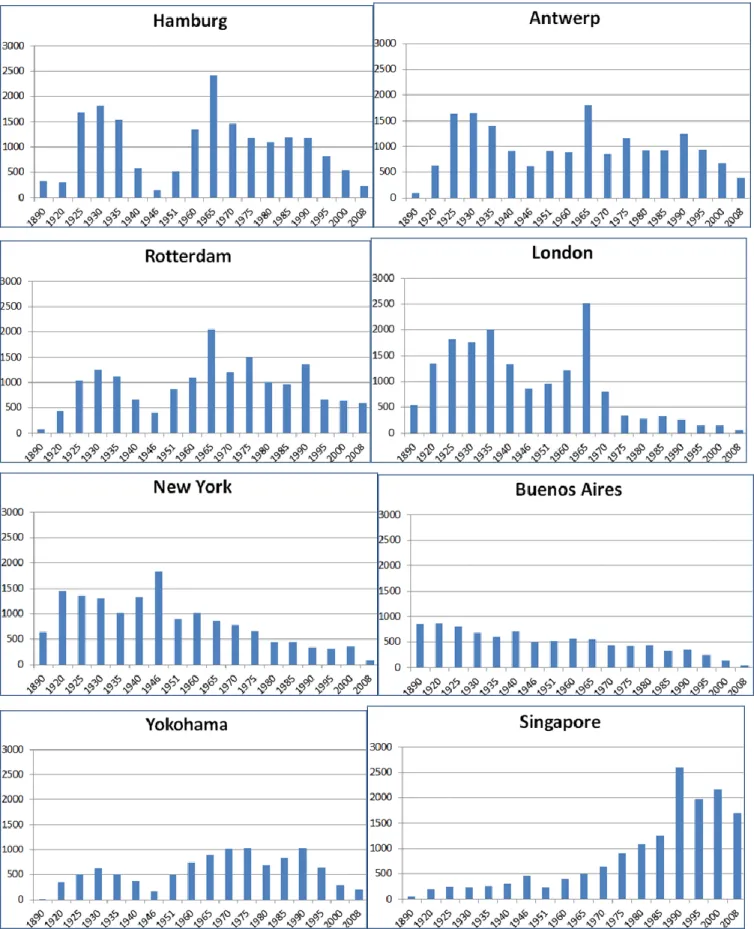
Another aspect of change is the evolution of individual ports between 1890 and 2008 (Figure 4). Based on the same scale and measurement unit, it is possible to offer a direct comparison of the number of calls from one port to another. Before the age of megaships, variations of vessel calls directly illustrated the vitality of ports and their hinterlands, but since the 1970s, a decline of vessel calls might relate to either traffic decline or increasing ship size.
Figure 3. Spatial distribution of vessel calls, 1890-2008 N.B. circles are proportional in size to the volume of vessel calls
The impact of major events such as World War II have been clearly visible on ports and shipping, and have been more severe for certain cities than others. Hamburg, Yokohama, and, to a lesser extent, London all struggled greatly after the destruction of WWII, however, during this period of history, New York was growing, whilst Buenos Aires and Singapore offer two contrasted pathways, with continuous decline and continuous growth respectively. If more ports were included in Figure 4, the figure would have displayed that ports in proximity often share similar trajectories as they went through identical events.
However, every port responds differently to shocks and transitions in terms of speed of traffic recovery and technological adaptation. This is the goal of this article, to go further by identifying possible factors of ports’ resilience. Long-distance linkages also create distant proximities, such as in the era of colonial rule, which is marked by certain permanencies, until nowadays, in terms of North-South exchanges and core-periphery trade patterns.
Towards new horizons
By realigning the academic focus onto a more in-depth analyses of the uneven effects of large-scale shocks and transitions, such as wars, decolonisation, financial crises and technological breakthroughs, on the global maritime network, one can re-imagine the way in which growth is fostered within the port and shipping industry. Other examples of possible new opportunity consist of the retro-simulation of past events such as the opening, closing, and re-opening of the Suez and Panama Canals. Also, more information about vessels is necessary.
Figure 4. Traffic evolution at selected world ports, 1890-2008
By utilising the historical data of the past, we can forecast future possible changes in port and maritime traffic. There are certain rules by which ports gain or lose connectivity and these can be measured and compared in different contexts. The ability of ports to absorb economic transitions and technological innovations in a long-term perspective is at centre stage in the port and maritime business. A better definition and understanding of port growth mechanisms will provide potentially revolutionary views on such
matters. Can such investigations provide useful support to the decision-making imperatives of contemporary ports and transport chain operators? Answering these questions will require further analyses of past events and trajectories, without ignoring the diversity of local contexts and the complexity of local-global interactions in the contemporary world economy and society, yet taking the first steps on the path could breed a whole new dimension to the practice of good port governance.
About PortEconomics
PortEconomics is a web-based initiative aiming at generating and disseminating knowledge about seaports. It is developed and empowered by the members of the PortEconomics group, who are
actively involved in academic and contract research in port economics, management, and policy. Since October 2012, Port Technology International and PortEconomics are engaged in a partnership. www.porteconomics.eu
About the author
Dr Ducruet obtained his PhD in Transport Geography from Le Havre University in 2004 and has been research fellow at the CNRS Géographie-cités research unit since 2009. His research interests include network analysis, urban-regional development, and transport geography, with a particular focus on port cities and maritime flows in Asia and Europe. Dr Ducruet currently leads the European Research Council (ERC) Starting Grant project “World Seastems” ( www.world-seastems.cnrs.fr) about the evolution of global maritime flows since the late nineteenth century.
Contact details : Dr. César Ducruet
CNRS & UMR 8504 Géographie-cités 13 rue du Four
F-75006 Paris, France Tel. 0033(0)140464000 Fax. 0033(0)140464009 Email. [email protected]