HAL Id: hal-01348469
https://hal.archives-ouvertes.fr/hal-01348469
Submitted on 28 Jul 2016
HAL is a multi-disciplinary open access
archive for the deposit and dissemination of
sci-entific research documents, whether they are
pub-lished or not. The documents may come from
teaching and research institutions in France or
abroad, or from public or private research centers.
L’archive ouverte pluridisciplinaire HAL, est
destinée au dépôt et à la diffusion de documents
scientifiques de niveau recherche, publiés ou non,
émanant des établissements d’enseignement et de
recherche français ou étrangers, des laboratoires
publics ou privés.
Changes of the Baltic Sea coastal urban region (with
example of Klaipeda settlement)
Jelena Galiniene, Daiva Verkuleviciute-Kriukiene, Sébastien Gadal
To cite this version:
Jelena Galiniene, Daiva Verkuleviciute-Kriukiene, Sébastien Gadal. Changes of the Baltic Sea coastal
urban region (with example of Klaipeda settlement). 1st Baltic Earth Conference: Multiple drivers for
Earth system changes in the Baltic Sea region, Jun 2016, Nida, Lithuania. pp.195-196. �hal-01348469�
1
st
Baltic Earth Conference
Multiple drivers for Earth system changes in the Baltic Sea region
Nida, Curonian Spit, Lithuania
13 - 17 June 2016
Conference
Proceedings
International Baltic Earth Secretariat Publication No. 9, June 2016
Edited by
Marcus Reckermann and Silke Köppen
Impressum
International Baltic Earth Secretariat Publications
ISSN 2198-4247
International Baltic Earth Secretariat
Helmholtz-Zentrum Geesthacht GmbH
Max-Planck-Str. 1
D-21502 Geesthacht, Germany
www.baltic-earth.eu
balticearth@hzg.de
Front page photo:
The Great Dune near Nida on the Curonian Spit, Neringa, Lithuania
(Martin Stendel)
Organizers and Sponsors
Klaipėda University, Lithuania
Helmholtz-Zentrum Geesthacht
Centre for Materials
and Coastal Research, Germany
Swedish Meteorological and
Hydrological Institute
Norrköping, Sweden
Uppsala University, Sweden
Leibniz Institute for Baltic Sea Research
Warnemünde, Germany
Conference Committee
Juris Aigars, Latvia
Franz Berger, Germany
Inga Dailidienė, Lithuania
Jari Haapala, Finland
Sirje Keevallik, Estonia
Karol Kulinski, Poland
Andreas Lehmann, Germany
H. E. Markus Meier, Germany and Sweden (Chair)
Kai Myrberg, Finland
Carin Nilsson, Sweden
Anders Omstedt, Sweden
Irina Partasenok, Belarus
Piia Post, Estonia
Marcus Reckermann, Germany
Gregor Rehder, Germany
Anna Rutgersson, Sweden (Vice-Chair)
Corinna Schrum, Germany
Benjamin Smith, Sweden
Martin Stendel, Denmark
Hans von Storch, Germany
Ralf Weisse, Germany
Sergey Zhuravlev, Russia
Organisation Committee
Inga Dailidienė, Lithuania
Hans-Jörg-Isemer, Germany
Silke Köppen, Germany
H. E. Markus Meier, Germany and Sweden
Marcus Reckermann, Germany
Anna Rutgersson, Sweden
Acknowledgments
This conference is jointly organized by the University of Klaipeda, Lithuania, and the
International Baltic Earth Secretariat at Helmholtz Zentrum Geesthacht, Germany. We would
like to thank the sponsors for generously supporting the conference. Furthermore, we would
like to thank the local organization committee, in particular Inga Dailidienė and Eglė
Baltranaitė, and the numerous student helpers. Sabine Billerbeck, Sabine Hartmann and
Hans-Jörg Isemer are acknowledged for their invaluable support before and during the
conference. Very special thanks go to Silke Köppen of the International Baltic Earth
Secretariat for brilliantly organizing the preparation of the conference and associated
publications.
Changes of the Baltic Sea coastal urban region (with example of Klaipeda
settlement)
Jelena Galiniene
1,2, Daiva Verkuleviciute
2and Sebastien Gadal
21 Klaipėda University, Address: 84, H. Manto, LT-93185, Klaipeda, Lithuania 2 Aix-Marseille Université, CNRS ESPACE UMR 7300
1. Introduction
Nowadays settlements location for people has not such a big meaning in distance from their living and working place due globalization and telecommunications advancements (Zhong et al. 2014 (a); Shatu et al. 2014; Neuman 2005; Žaromskis 2001), as well as one of the main residence dispersion factors in place, its landscape and as well as the distinction of climate comfort. Climate change in the future may be affected by urbanization tendencies. Therefore, it is necessary to research on climate impacts on human life, in social trends.
Peri-urbanization sets settlements location behind the city and at the moment they are facing with poor social and technical infrastructure, there have been seen negative impact on landscape and CO2 emission (Wang et al. 2014; Newman et al. 2014; Poom et al. 2014; Brand et al. 2009; Neuman 2005; Europos Sąjungos regioninė politika 2007). In 2004, European Commission has described importance of sustainable urban development and it is important to ensure efficient land use as non-renewable resource (European Journal of Spatial Development, 2012; Zaleckis 2010; Poom et al., 2014).
The process of urban sprawl in Klaipėda and surrounding areas has negative meaning as population moving to new suburbs because of search for better living conditions and cheaper housing (Cirtautas 2013). Besides urban sprawl negative meaning, Kavaliauskas had adopted a new term – anthropecosystem. He notes that population always will form, work, rest and live in places which are the most suitable and comfort for them, does not matter how far away it will be from working and living places (Kavaliauskas 1984).
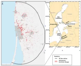
The goal of this study is to analyse the impact of urban sprawl on landscape around Klaipeda sity ettlements, Lithuania (Fig. 1). The main aims are: (I) find differences in location of settlements during period since 2005 to 2013; (II) predict possible settlements expansion till 2020; (III) evaluate possible urban sprawl impact on Klaipėda city and suburbs.
2. Study area and method
Klaipeda is the largest town at the western Lithuania, with the number of population 158 541 (2013 Census data) and it is third largest city in terms of population in Lithuania. Here is located one of the major harbours at the south-eastern of Baltic Sea. In Klaipėda surrounding settlements is located several tourist attraction points, and summer resorts, such as well-known Palanga and Nida, Marine museum with the only one dolphinarium in all Baltic countries. At the same time almost 0,5% of Klaipėda city territory and 48% of Klaipėda district territory belongs to the National park area and Natura 2000 or other prohibited area (State Cadastre of Protected Areas, 2014).
In order to make prognosis of future urban sprawl, to predict change of land use and ecological and social problems, it is important to do spatial modelling, which nowadays is more precise when mathematical calculations (Cheng, Masser, et.al. 2003; Gadal 2011 (b)) what was done in this research.
In order to get the most accurate data on suburbanization processes, was gathered several methods: GIS, using orthopoto and georeferential GDB10LT databases and also mathematical – statistical method in comparison with received visual results. GIS methods were used to identify changes in the land cover change in Klaipėda and its surroundings. Both – macro (city level) and micro level (suburbs) changes were investigated during research.
In this study, was used year 2005 and 2013 layers of Lithuanian territory M 1:10 000 georeferential database year 2005 and 2013 and the 2005 and 2010 Lithuanian territory digital orthophoto M 1:10 000 map ORT10LT (Fig.1). Orthophoto’s map layers were used to make geometrical correction of georeferential GDB10LT database layers in order to look for settlements territorial change during analysed period.
Figure 1. Territorial change of settlements during 2005-2013, ha.
3. Results
Study shows, what the biggest suburbanization processes in Klaipėda have been spotted in 5-10 km eastwards and not significantly in south – east and northern direction from the city (Fig. 1). Territory in 5 km distance from Klaipėda city centre have increased by 632,65 ha, as well as in all studied area enlarged by1090,94 ha. The most significant suburbanization processes have been in settlements of Klaipėda district: Slengiai, Triušeliai,
Budrikai, Mazuriškiai. Here was recorded by 56,63% of all changes in Klaipėda district.
One of the best indicator, showing urban sprawl and change of physical landscape is the change of number of population in city and suburban areas (Cirtautas 2015, Newman et al. 2014; Europos Sąjungos regioninė politika 2007). Correlation shows, what population number in Klaipėda city is decreasing but in Klaipėda district increases exponentially (r=-0.92806).
According georeferential data analysis, settlements territory of Klaipėda city suburbs expanded by 1090.94 ha during by 2005-2013. Mostly, suburbs have expanded eastwards and northern in 5 km distance from Klaipėda city (632.65 ha) that is directions parallel to the highway Klaipėda-Vilnius, and on the way to Palanga resort.
If territorial growth of settlements around Klaipėda city will be the same as during 2005-2013 period, settlements around Klaipėda city in 5 km radius, would expand up to 1245,77 ha till year 2020. Future urban sprawl direction should remain the same – eastwards and northern from Klaipėda city.
4. Discussion and conclusions
Graphical and statistical analysis of study area showed strong evidence of urban sprawl in Klaipėda suburban areas, especially in 25 km distance. As found Bouwman et al. (2005) in their study, urbanization has a clear effect on human mobility. In this case it changes everything, as Klaipėda city and its suburban municipality governments should rethink transportation system and infrastructure in order to make urban-rural continuum, which describes Bouwman, greener, more suitable for living and more ecological, as the right city design can enhance the use of car alternatives (Zhong et al. 2014 (b), Poom et al. 2014; Jansen et al. 2011). It is very important to think about car alternatives while communication between Klaipėda city and suburbs at the moment is quite weak. Wang et al. (2014) has empirically proven that sub-urbanization have a significant impact on commuting CO2 emission increase.
Study results shows, that Klaipėda region is not exception in the Europe. We are facing fast urban sprawl which has negative impact on regions’ landscape and ergonomics’, social, economic and psychological human being in newly inhabited territories (Kavaliauskas 1984; Europos Sąjungos regioninė politika 2007). Instead of green and recreation zones concentration in suburban areas (Jansen et al. 2011), population moving to live there, leaving cities emptier.
Knowing urban sprawl directions will let us predict future scenarios of land use and will help for urban planners to meet populations’ daily needs in order to avoid mistakes which were made some centuries ago (Zhong et al. 2014 (a); Kavaliauskas 1984; Žaromskis 2001). Canada already taking action in drawing borders, there urban sprawl is not possible, in order to protect the land from residential use and let spread farming.
The analysis of this research showed what no proper action has been taken in order to avoid urban sprawl and Klaipėda’s city emptiness. Also climate change projections and adaptations should play important role in future planning documents of Klaipėda city and its district settlements.
References
Brand, C., Preston, J.M., 2009. ‘60-20 emission’—The unequal distribution of greenhouse gas emissions from personal, non-business travel in the UK. Transport policy, 17:9-19.
Bouwman, M.E., Voogd, H., 2005. Mobility and the Urban-Rural Continuum. GBER, vol. 4(3):60-69.
Cirtautas, M. 2014. Suburban areas centrally collected data use in residential areas development studies. Kvalifikacinio mokslo darbo Nr. 367 ataskaita, Urbanistinės analizės mokslo laboratorija, VGTU, Vilnius.
Cirtautas, M. 2013. Urban Sprawl of Major Cities in the Baltic States. Architecture and Urban Planning. Vilnius Gediminas Technical University, 7:72-79.
Cheng, J., Masser, I., Ottens, H. 2003. Understanding urban growth system: theories and methods. Department of Urban and Regional Planning and Geo-Information Managment, International Institute for Geo-Information Science and Earth Observation (ITC). The Netherlands.
Europos Sąjungos regioninė politika, 2007. Augantys regionai, auganti Europa/Growing regions - growing Europe. Ketvirtoji ekonominės ir socialinės sanglaudos ataskaita. 15-16. European Journal of Spatial Development 2012. Published by
Nordregio, Nordic Centre for Spatial Development and OTB Research Institute, Delft University of Technology.
Gadal, S., 2011 (a). The socio-ecological challenge of the metropolised territories: key-notes. University of Versaille Sanit-Quentin-en-Yvelines.
Gadal, S., 2011 (b). Urban multilevel geographical information satellite generation. University of Versaille Sanit-Quentin-en-Yvelines.
Jansen, J.O., Christensen, H.T., Gram-Hanssen, K., 2011. Sustainable urban development – compact cities or consumer practices? Danish Journal of Geoinformatics and Land Management, Vol. 46(1):50-64.
Neuman, M., 2005. The compact city Fallacy. Journal of Planning Education and Research 25:11-26
Newman, L., Nixon, D., 2014. Farming in an Agriburban Ecovillage Development: An Approach to Limiting Agricultural/Residential Conflict. Sage Open, October-December 2014: 1–10
Poom, A., Ahas, R., Orru, K. 2014. The impact of residential location and settlement hierarchy on ecological footprint. Environment and Planning A, volume 46, pp. 2369-2384. Shatu, F.M., Kamruzzaman, Md., Deilami, K. 2014. Did Brisbane
grow smartly? Drivers of city growth 1991-2001 and lessons for current policies. Sage Open, pp 1-19.
Sudhira, H.S., Ramachandra, T.V., Jagadish, K.S., 2004. Urban sprawl: metrics, dynamics and modelling using GIS. International Journal of Applied Earth Observation and Geoinformation, 5 (1), 29-39.
Wang, Y., Hayashi, Y., Chen, J., Li, Q., 2014. Changing urban form and transport CO2 emissions: an empirical analysis of Beijing, China. Sustainability 6:4558-4579
Zaleckis, K., Kamičaitytė-Virbašienė, J., 2010. Darnus urbanistinių struktūrų vystymasis: Kauno miesto atvejis/Sustainable urban structure development: Kaunas city example. Kauno technologijos universitetas.
Zhong, C., Huang, X., Arisona, S.M., Schmitt, G., Batty, M. 2014 (a). Inferring building functions from probabilistic model using public transportation data. Computers, Environment and Urban Systems 48:124-137.
Zhong, C., Huang, X., Arisona, S.M., Schmitt, G., Batty, M. 2014 (b). Detecting the dynamics of urban structure through spatial network analysis. International Journal of Geographical Information Science, Taylor & Francis. Žaromskis, R., 2001. Skirtingos žmonių veiklos poveikis pietryčių
Baltijos krantų raidai/Different human activities impact on South-Eastern Baltic coastal zone. Geografijos metraštis, Vilnius. 34(1):59-72.
Каваляускас, П., 1984. Проблема комплексной оценки антропологического потенцциала территории. Geographia Lituanica, Vilnius. XXI, 180-190.