Designing BRT-oriented development
The MIT Faculty has made this article openly available.
Please share
how this access benefits you. Your story matters.
Citation
Zegras, Chris et al. "Restructuring public transport through Bus
Rapid Transit: An international and interdisciplinary perspective."
Restructuring public transport through Bus Rapid Transit: An
international and interdisciplinary perspective, edited by Juan
Carlos Munoz and Laurel Paget-Seekins, University of Chicago
Press, 2016, 181-208 © 2016 University of Chicago Press
As Published
http://press.uchicago.edu/ucp/books/book/distributed/R/
bo23482661.html
Publisher
University of Chicago Press
Version
Author's final manuscript
Citable link
http://hdl.handle.net/1721.1/113325
Terms of Use
Creative Commons Attribution-Noncommercial-Share Alike
1
Chapter 10 - Designing BRT Oriented Development
Chris Zegras (MIT), Anson Stewart (MIT), Rosanna Forray (PUC), Rocío Hidalgo (PUC), Cristhian
Figueroa (PUC), Fábio Duarte (PUCPR), Jan Wampler (MIT)
Forthcoming (2016) in:
Restructuring public transport through Bus Rapid Transit: An international and
interdisciplinary perspective (Juan Carlos Munoz and Laurel Paget-Seekins, Eds.), Policy Press.
Introduction <1>BRT signifies a concrete commitment to bus transit, encompassing coordinated institutional, financial, physical, and operational interventions. This commitment can catalyse wider urban development by improving local and metropolitan accessibility and urban spaces and streetscapes. This chapter explores prospects for such BRT-oriented development (BRTOD).
Transit-oriented development (TOD) aims to leverage the interactions between urban land use, mobility, and socio-economic systems. This chapter examines how BRT corridors might spur TOD, structuring the city and its spaces towards more equitable and transit-conducive urban forms. Specifically, it uses results from a graduate-level planning and design workshop set in two regions, Boston, Massachusetts and Santiago de Chile,1 to explore how BRT corridors might catalyse cross-disciplinary approaches to
urban development. Adopting an integrated approach to the design of transit routes and infrastructures, surrounding public spaces, real estate projects, public policy and governance, the students’ proposals for these two corridors highlight BRT’s transformative potential across diverse urban settings.
The next section provides a brief theoretical and empirical background. The third section summarises the workshop’s approach and contexts; the fourth presents workshop results, illustrating various possible design and planning innovations for realising BRTOD. The conclusion synthesizes lessons learned.
Theoretical perspectives and empirical precedents <1>
Basic economic theory suggests that households and firms make trade-offs between travel costs, land area, and other relevant attributes in their location decisions. These interactions essentially occur between two urban sub-systems: land use and mobility. Land uses determine the locations of potential trip origins and destinations and influence the relative attractiveness of different travel modes. Mobility, in turn, influences the relative desirability of different locations, improving ‘connectivity,’ but sometimes with negative consequences such as pollution. The interaction of these subsystems defines urban accessibility: the degree to which people and firms can reach activities, services and goods (Geurs and van Wee, 2004).
2
A major transportation investment will change accessibility across a metropolitan area, impacting locations’ relative attractiveness. System users and residents may benefit from lower travel costs, higher quality of life/well-being (see, for example, Cao, 2013) and possibly increased social capital (Kamruzzaman, et al, 2014). These effects should be capitalised into land values (Zegras et al, 2013). The accessibility benefits of mass transit, which enables relatively high concentrations of persons and firms in specific areas, include potential agglomeration economies, in the form of expanded labour markets, reduced costs of inputs, and enhanced knowledge spillovers (Chatman and Noland, 2014), which may also influence land values.Capitalising on these interactions has a long history in urban development. In the USA, for example, real estate interests in the early 1900s developed urban rail projects to increase the value of their land holdings, forming ‘streetcar suburbs’ (Warner, 1962). Baum-Snow and Kahn (2000) find that land prices, development, and users respond modestly to new rail transit investments in five metropolitan areas in the USA; with ridership increases attributable to existing residents and new residents attracted to the transit-accessible areas. Numerous reviews (including Martínez and Viegas, 2009) of the now large body of empirical research on rail transit and land value effects suggest that – despite variations in contexts, types of properties analysed, types of infrastructures considered, and so on – property values around transit stations are typically higher, presumably reflecting station-proximity benefits valued by users, land owners, and developers.
TOD aims to maximise land use-transit synergies, using transit investments and services to guide land development and, in turn, using urban form and design to boost transit ridership. Successful TOD includes attractive pedestrian access to quality transit service, compact, mixed land uses and safe environmental conditions (Suzuki et al, 2013). For maximum impact, TOD typically requires coordinated policies and regulations (such as parking restrictions and appropriate zoning), correct corridor alignment and station placement, a climate of economic growth, and some demand for density (Handy, 2005). TOD should also fulfil social development objectives, ensuring, for example that lower-income residents are not displaced by increased property values and higher-income residents more likely to use cars (Suzuki et al, 2013).
Numerous detailed case studies and guidelines on effective TOD have been published. Rather than duplicating these efforts, this chapter highlights promise and challenges for TOD specifically related to BRT projects.
BRTOD promise <2>
In theory, BRT’s ridership, development, property value, and land use impacts can equal those of any other high quality public transport. Ben-Akiva and Morikawa (2002) find evidence supporting the idea that users care about service characteristics, not necessarily the transit mode itself. Chatman’s (2013) analysis of light rail in New Jersey suggests that the form of urban development, not the transit mode, impacts ridership and that, in fact, regular bus service has stronger behavioural effects than light rail, after controlling for urban form characteristics. Nelson et al’s (2012) examination of Eugene’s (Oregon) BRT inaugurated in 2007 reveals that areas within 400 meters of a station attracted more jobs relative to
3
the rest of the metropolitan area. These studies support the premise that BRT has similar TOD potential to rail-based transit.Emerging support for BRTOD also comes from property value studies. Rodríguez and Targa (2004) studied apartment rental asking prices about one year after Bogotá inaugurated its TransMilenio BRT system and estimate a 7-9% increase in rental asking prices attributable to station proximity; interestingly they find no significant effect due to the system’s regional accessibility. This result suggests that the market does not value the initial BRT line’s relative regional accessibility gains; rather, the value comes from station-area proximity, which might be associated with public space improvements. In a later analysis, Rodríguez and Mojica (2009) find that subsequent TransMilenio extensions were associated with a 13-14% increase in property asking prices along the original line, suggesting regional accessibility gains may accrue with network growth.
More recently, for the Seoul case, Cervero and Kang (2011) find a 5-10% premium for residential property values within 300 meters of a BRT stop and a 3-26% premium for non-residential property within 150 meters of BRT stop. Finally, Perk et al. (2013) examined Boston’s Washington Street corridor, where Silver Line stops were associated with a residential property value premium of up to 7.6%.
In terms of land use changes induced by BRT, Bocarejo et al. (2013) find evidence that from 2001 to 2008, TransMilenio station areas increased in density relative to areas in the city without BRT; they suggest this happened without any supportive regulatory changes. Jun (2012), using a simulation model for Seoul, finds the BRT will likely increase firm location in the city centre at the expense of the suburbs (with concomitant relative changes in land values), but with no effects on residential redistribution. Finally, evidence is emerging that BRT station area physical characteristics influence ridership. Cervero et al. (2010) find population density, distance to nearest stop, and parking capacity significantly explain ridership at Los Angeles’ (CA) BRT stations. Estupiñán and Rodríguez (2008) find that characteristics favouring walking and bicycling (for example, sidewalk quality, amenities, and bicycle facilities) and disfavouring car use (for example, land use mix and density) were related to higher TransMilenio boardings. In Jinan, China, Jiang et al. (2012) find support for the argument that BRT station type (for example, terminal), density, and corridor design influence the distances users will walk to access the system.
BRTOD challenges <2>
Despite increasing empirical support of BRTOD potential, numerous challenges exist, from the streetscapes to the stations, station areas, corridors, and up to the city-wide level. Without mitigation, these challenges undermine BRTOD possibilities.
BRT’s at-grade operation, with higher speed and higher capacity vehicles, requires special attention to corridor design (see Chapters 9 and 16). Often implemented on wide rights of way with ample motor vehicle space, BRT needs careful design of civic spaces that do not pose barriers for pedestrians and cyclists. For example, Lee et al. (2013) find that ‘walkable’ neighbourhoods in Boston, particularly those with good accessibility to retail, are correlated with more traffic crashes and higher pedestrian risks. In
4
this sense, BRTOD must include urban design interventions that foster safer mobility, especially for schoolchildren, older adults, and other vulnerable users.In the study of the initial TransMilenio system discussed above, for example, Rodríguez and Targa (2004) find residential rental asking prices to increase with distance away from the BRT corridor, by a magnitude greatly exceeding the value gained from station-area proximity.2 This result may simply
reflect the negative effects of adjacency to the arterial, with or without BRT on it; Rodríguez and Mojica (2009) find no evidence of negative effects due to corridor adjacency in the expanded TransMilenio network. BRT corridors may bring perceived and real negative effects, from the rights of way, air and noise pollution, and safety concerns of the vehicles themselves. In areas with diverse urban fabrics and multiple activities, BRT implementation requires a strategic approach to improving station-area surroundings and the entire corridor, with special care to mitigate possible negative externalities that could compromise projects.
Social inclusion poses another important challenge for BRTOD. In general, TOD may induce ‘gentrification,’ a neighbourhood’s change towards higher income residents and/or higher property values. The latter can particularly impact renters, who may be displaced by landlords raising rents in affected neighbourhoods (Freeman, 2005). When TOD produces such outcomes, it might be particularly inequitable if lower income households, the most transit dependent, suffer decreased accessibility by being displaced from the transit-improved areas. Kahn (2007) examines 14 US cities with rail transit investments between 1970 and 2000 and finds mixed gentrification evidence, as measured by home price dynamics and share of college graduates in the affected areas.
In her assessment of BRTOD in North America and Australia, Judy (2007) identifies regional and local institutional challenges to realising BRTOD. Typically, BRT initiatives come from a metropolitan-scale agency, while land development is governed at the neighbourhood scale. In other words, land regulations, transportation planning, transit operations, and relevant financial instruments tend to reside in separate entities, often at different levels of government, requiring horizontal and vertical policy integration. BRTOD ultimately requires careful and unconventional considerations of real estate, governance, planning, and policy forces. Chapter 5 discusses these institutional relationships in greater detail.
In sum <2>
Just like TOD more generally, BRTOD aims to capitalise on the benefits that mass transit can bring to cities, including the possibilities to leverage improved accessibility, enhance agglomeration economies, address regional equity, and structure urban growth towards lower automobile dependency. As a road- and tyre-based transit mode, BRT has particular characteristics, which both enhance and impair its TOD potentials (see Table 10.1).
5
Table 10.1: BRT’s theoretical TOD strengths and weaknesses relative to rail-based transitAttributes Potential Strengths Potential Weakness Implementation
Speed Shorter planning and construction
timeline brings accessibility benefits more quickly for TOD potentials
Lower cost may encourage less detailed and comprehensive environmental and social assessments
Institutionality Lower capital cost may allow for more local or less complicated financing
Greater need for cooperation between transit, traffic, public works, and development authorities
Cost Cover a broader area with ‘mass’ transit,
expanding TOD potential
Bus viewed as mode for the ‘poor’; bad image
Flexibility Infrastructure can be upgraded according to demand
Potential impermanence or under-delivery of services and infrastructure Design
Rights of Way Using existing roadways can reduce space dedicated to private vehicles
Large dedicated infrastructures can pose surface-level barriers
Stations and Environs
Enhance street-level public space Take space from and produce negative externalities for public amenities, real estate projects
Streetscapes Innovatively integrate pedestrian, bicycle and motor vehicle infrastructures
Engineering, technical, design barriers to multi-modal infrastructures
Operations
Flexibility Services can be ‘demand-responsive’, modified/enhanced/expanded
Perceived and/or real concerns of service quality, service impermanence
Air/Noise Pollution, Safety
May stimulate innovative mitigation designs
Negative impacts on quality of life, attractiveness, property values
Multi-modalism Innovatively integrate pedestrian, bicycle
and motor vehicle flows
Vehicular and transit congestion, risks of multiple users and conflicting movements
6
Method and contexts: international BRT corridor design workshop <1>The workshop <2>
To explore the potentials for realising BRTOD, two distinct contexts – Boston, MA (USA) and Santiago de Chile – were examined through a graduate-level urban planning and design workshop, co-taught in 2013 at the Massachusetts Institute of Technology (MIT) and the Pontificia Universidad Católica de Chile (PUC). The workshop’s two fundamental questions were “How can BRT corridor projects drive new
integrated approaches to urban development?” and “What urban design and policy measures might
leverage these transit investments into wider urban change?” These research questions were identified by the workshop instructors, in consultation with stakeholders in both cities. In this academic exercise, students were tasked with exploring imaginative design proposals that could extend practitioners’ thinking beyond traditional practical constraints.
The workshop involved 29 students with backgrounds in transportation planning and engineering, urban planning and urban design. This mixed composition aimed to encourage participants to consider the complex interactions among relevant dimensions and disciplines. Students from ten countries brought a wide range of international perspectives on BRTOD challenges and opportunities.
Workshop leaders selected one potential BRT corridor in both cities, focusing on each for one-half of the 15-week semester. Both corridors cut across a reasonably wide range of their respective urban contexts; for each, discrete segments were identified to vary contextual conditions and expand the range of planning and design innovations discovered and the generalisability of the results. Field work in both cities started with a weeklong charrette and site visit by all students and faculty, followed by five weeks of working in inter-university groups assigned to the corridor segments identified. Although the workshop included discussions with, and final presentations to, stakeholders (representatives from transit agencies, municipalities, and citizen advocacy groups), time constraints impeded deeper stakeholder engagement.
Comparative contexts <2>
Representing different socio-economic, political-institutional, transportation, and urban contexts, the two settings provide some opportunity to discern the various factors that might influence corridor and station area planning and design. The comparison that follows offers an abbreviated, non-exhaustive, overview of pertinent characteristics.
Politically, Chile represents a younger and more centralised democracy, with a lower share of total government revenues raised and expended at the non-Central level relative to the USA’s federal democracy (Inman, 2007). As a result, authority for land use and transportation regulation tends to be more local in the United States (see Table 10.2).
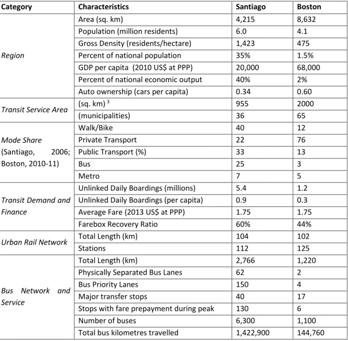
Table 10.3 compares the two metropolitan settings. In Boston, Massachusetts’ state capital, public transportation services are operated almost entirely by a state agency, the Massachusetts Bay Transportation Authority (MBTA). In Santiago, Chile’s capital and economic and population centre, the
7
national government plays a prominent role in investing in and regulating transportation services. Transit services are operated by public (Metro) and private (bus) companies, and planned and regulated by a relatively new authority, the Directorate for Metropolitan Public Transport (DTPM), which depends directly upon the national Ministry of Transport. The two places have roughly the same public transport fares, meaning that relative to average incomes, Santiago’s public transport system is less affordable. Housing affordability is a concern in both places, although comparable data are not readily available; in Boston median housing prices were 5.4 times greater than median household income in 2013 (Demographia, 2014). In gross metropolitan-wide terms, Santiago is three times as dense as Boston. Table 10.2: transportation and land use regulatory authorityChile USA
Transportation Capital
Investment
Transit system: national and municipal general budget
Highways: Private concessions: user fees (such
as tolls)
No earmarking of motor fuel taxes
Transit system : dedicated federal and state motor fuel taxes with some local and metropolitan scale contributions (such as sales taxes) Highways: dedicated federal and state motor fuel taxes, some toll roads
Transportation Operations
User fees (fares, tolls) and national budget subsidies
User fees (fares, tolls) and state and local government subsidies
Land Use Regulation
Approval from national Ministry of Housing and Urbanism (MINVU) required
Highly local municipal control
The cities have different histories of public involvement and civic engagement in transportation, land use, environmental and equity concerns. Boston was at the forefront of the USA’s citizen-led ‘highway revolt’ in the late 1960s, culminating in a state-declared moratorium on highway building within most of the urban area. Transportation controversies remain today, as some jurisdictions and communities suffer from relatively poor service and accessibility, plus exposure to transportation-related negative externalities, like air pollution (see Bullard, 2003). Boston has a large number of transportation-focused citizen advocacy organisations.
In Chile, engaged citizen advocacy organisations emerged in the wake of the relatively recent return to democracy after the Pinochet dictatorship (1973-1990). The role of public participation in formal decision-making remains somewhat weak, characterised by residual antagonisms and a lack of formal institutional structures, leading to a protest-oriented dynamic (Fernández and Ordóñez, 2007). Many organisations mobilised and subsequently formalised after the city’s own nascent highway revolt against the Costanera Norte urban highway proposal in the mid-1990s (Silva, 2013). Efforts to improve
bus-8
based public transportation through corridor widening have met with large-scale protests against expropriations and tree-removal.Table 10.3: the BRT corridors’ metropolitan contexts
Category Characteristics Santiago Boston
Region
Area (sq. km) 4,215 8,632
Population (million residents) 6.0 4.1 Gross Density (residents/hectare) 1,423 475 Percent of national population 35% 1.5% GDP per capita (2010 US$ at PPP) 20,000 68,000 Percent of national economic output 40% 2% Auto ownership (cars per capita) 0.34 0.60
Transit Service Area (sq. km) 3 955 2000
(municipalities) 36 65 Mode Share (Santiago, 2006; Boston, 2010-11) Walk/Bike 40 12 Private Transport 22 76 Public Transport (%) 33 13 Bus 25 3 Metro 7 5
Transit Demand and Finance
Unlinked Daily Boardings (millions) 5.4 1.2 Unlinked Daily Boardings (per capita) 0.9 0.3 Average Fare (2013 US$ at PPP) 1.75 1.75
Farebox Recovery Ratio 60% 44%
Urban Rail Network Total Length (km) 104 102
Stations 112 125
Bus Network and Service
Total Length (km) 2,766 1,220
Physically Separated Bus Lanes 62 2
Bus Priority Lanes 150 4
Major transfer stops 40 17
Stops with fare prepayment during peak 130 6
Number of buses 6,300 1,100
Total bus kilometres travelled 1,422,900 144,760
Notes and Sources: Santiago’s GDP and transit fare in PPP exchange values. DTPM, 2013; MBTA, 2011. SECTRA, 2006; MTS, 2011; Santiago 2006 travel and household related data come from 2006 household travel survey which may have been biased towards upper-income households.
The corridors <2>
The 21-km Santiago corridor, Gran Avenida, a principal north-south radial axis of the city, runs from the downtown through older commercial areas, middle- and lower-income neighbourhoods, toward older industrial areas and the rapidly suburbanising south. Comprised of a couplet of one-way streets in
9
downtown that merge into a wide arterial, and branching again into two streets in the south, the corridor requires upgrades to improve reliability for the existing 25 bus routes and 200,000 average weekday passengers and to better integrate with existing and planned rail services nearby. Gran Avenida exemplifies Santiago’s traditional pattern of urban segregation, with middle and higher income residents near the historic centre and groups of lower income residents concentrated in dense peripheral areas. Alleviating this segregation, and the associated lack of services and opportunities in the outlying areas, is a key challenge.At the same time, the avenue connects important amenities and government facilities, including forty-three educational institutions, forty-three regional shopping centres, two major hospitals, and a military base. Gran Avenida presents an opportunity to demonstrate integrated design of a metropolitan-scale multi-modal corridor, renew existing urban fabric and public spaces, and integrate suburban expansion areas. Key challenges include narrow rights-of-way along certain segments, intermodal integration, and community opposition to bus-based transit enhancements in favour of a Metro extension.
The 12-km Boston corridor is a prospective, partially circumferential, route, connecting older de-industrialising areas in the north with high-technology, higher education and health centres, and lower income communities of colour in the city’s south. The corridor would entail the inauguration of new bus routes. Concepts for such circumferential transit through the dense communities surrounding Boston date back at least to the 1960s. Plans for a so-called Urban Ring project were put on hold in 2008, in part due to the cost of a tunnel segment demanded by stakeholders, but recent planning efforts have revived the possibility of new BRT corridors in the city.
The selected corridor, representing about one-third of the original Urban Ring, would help alleviate growing congestion in the transit network’s downtown core by improving connections between existing radial rail lines and two major employment centres, the Longwood Medical Area (LMA) and Kendall Square, while also increasing transit access for surrounding residential communities and potentially serving to spur redevelopment of urban brownfields. Key implementation challenges along the corridor somewhat echo the Gran Avenida case: limited right-of-way along certain segments, intermodal integration (including proposed use of an existing rail corridor), and community opposition to bus-based transit. The corridor also lacks infrastructure connections at key points.
Traversing diverse urban contexts, both corridors have considerable potential for BRTOD while exemplifying some of the challenges BRTOD might face. Communities’ past rejection of bus projects in both settings stems from many of the potential liabilities of BRT identified in Table 10.1; integrated design of urban space and policies could use BRT’s strengths to overcome these liabilities.
Figure 10.1 situates each corridor in its respective metropolitan context and Figure 10.2 provides a schematic representation of the corridors and the neighbourhood typologies (namely commercial core, central residential, marginal residential, neighbourhood subcentre, and brownfield/greenfield) they cross, divided into the segments analysed by the workshop teams.
10
Figure 10.1: the corridor metropolitan settings: Santiago (top) and Boston (bottom)12
Figure 10.2: corridor ‘transects’ – schematic representations of the selected Santiago (top) and Boston (bottom) BRT corridors, by segment13
Workshop proposals4 <1>Santiago’s Gran Avenida corridor <2>
Considering the varying widths, changing land uses, and distinct transport demands of each segment of Gran Avenida, the workshop proposed a range of transit priority configurations: shoulder bus-only lanes (without physical separation) in some segments and segregated centre-running bus lanes, with shoulder lanes for use by cars and bikes and through traffic re-distributed to parallel roadways, in others. While detailed demand estimates were not compiled, increased ridership from denser development in the corridor would likely be offset by regional trips shifting to better integrated Metro and regional rail lines;
14
bus boardings along Gran Avenida would remain close to current totals, but with shorter local trips and related positive impacts on street life.Major transfer stations include bus-metro and regional rail-bus interchanges. A major design challenge, epitomised by the current design of the La Cisterna station, is the physical and functional separation between large scale bus operations and the immediate surroundings. Proposed station designs emphasised pedestrian access and an opening-up of facades, generating fine-grained permeability with immediate environs (see, for example, Figure 10.3, top).
Proposed land use and urban design strategies vary along the transect. Strategies for the commercial and central residential neighbourhoods of San Diego focus on economic renovation and historic preservation, paying special attention to the ground-level streetscape. Recommendations for San Miguel emphasise controlled densification of residential, commercial, and service activities around the major intermodal transfer points (for example, the Franklin, Lo Ovalle, and La Cisterna Metro stations), with a focus on enhanced-quality pedestrian spaces in front of the area’s schools and public institutions through traffic calming. In Los Morros, where public housing suffers from personal safety concerns and scarce public space, the proposal aims to make the street into a place of social interaction and to introduce productive garden plots that encourage community activity. Along El Bosque, where the abutting air force base poses a short-term challenge and longer-term opportunity, the flexibility of phasing BRT was applied to transform the base into an integrated urban fabric and economic development hub, with station areas serving as interfaces with existing residential areas (Figure 10.3, bottom). BRT flexibility also played a role in the proposed phased suburban consolidation strategies identified for the Portales segment.
The range of urban contexts along the corridor requires consistent landscape and public space treatments, implying unified objectives (human-scale, multi-modality), but varying built forms. Achieving these results along a single structuring corridor, integrating socio-economic and demographic groups, and financing the associated public works projects all require new governance that can coordinate across existing jurisdictional and regulatory boundaries.
15
Figure 10.3: Illustrative examples of proposed interventions, including new public space around La Cisterna Intermodal Station (top); regional rail-BRT intermodal station at San Bernardo (middle); intermediate stations and new neighbourhood at El Bosque (bottom)Boston’s ‘Diamond Ring’ <2>
The workshop sought to produce innovative designs for circumferential transit that would inspire renewed attention for this corridor while building transit ridership. A sketch analysis using a travel survey and a four-step model run estimated 35,000 to 55,000 average weekday boardings along this new corridor in the short run, increasing to 80,000 after two decades of operation. The proposal rebranded this western portion of the Urban Ring as the Diamond Ring (DR), a nod to the famous Emerald Necklace park system the corridor intersects.
16
The proposed corridor occupies varied existing right-of-way configurations, from lightly used railroad tracks to wide avenues to narrow neighbourhood streets. The design proposals respond to heavy congestion at critical points, as well as to diverse surrounding urban contexts. In Somerville (see Figure 10.2), in concert with post-industrial brownfield redevelopment, initial services could operate on existing rights-of-way, but a new bridge would likely be required eventually to achieve full BRTOD potential. Strategies in the Cambridge segment include use of existing roads through a dense commercial core, before turning onto a segment utilising an existing rail right-of-way (and proposed to share with the rail). A major upgrade to a river crossing would then bring the corridor to the neighbourhood subcentre of Brookline, and the branches of a light rail line (the Green Line) running along the Emerald Necklace parks, requiring special design sensitivity. The final segment serves the LMA, a congested employment cluster, and the historically marginalised neighbourhood of Dudley Square in Roxbury.Similar to the Gran Avenida case, while the project aims for a coherent whole – unified by multimodal transfer points, bus priority, and the use of information technology at bus stops – the proposals reflect the heterogeneous settings and phased implementation. Major intermodal transfer stations would be linked to new mixed-use developments, including public facilities, residences, and offices. For transfer points adjacent to heavy rail and elevated highway infrastructure, such as at the Charles River Crossing and Sullivan Square, proposals included new public spaces that transform such infrastructure. In the case of Brookline, access to narrow existing streets would be restricted to public transit and abutters. Corridor implementation would entail phasing, with the first phase of the project, DR1, providing 3 to 5-minute peak headways and requiring 37 additional buses. Some existing services would be upgraded and rebranded to complement DR1 service. The workshop estimated US$360 million in up-front costs and US$18 million in annual operating costs, to be funded by a range of sources including tax-increment financing, joint development, transportation management agency contributions, and employer transportation fees.
The project opens new opportunities to improve housing, the environment, and equitable economic development in the region, but the current institutional structure inhibits the potential to maximise the DR’s viability and positive impact. In response, the workshop proposed a state-sponsored authority to implement the Diamond Ring, based on successful precedents in other places. This convening body would facilitate collaboration on housing and anti-displacement policies, environmental standards for transit-oriented (re)development, and economic development opportunities such as workforce training.
Synthesis <2>
Table 10.4 synthesises the challenges and planning/design responses derived from the workshop, categorised in five general urban contexts the workshop identified as typical of BRT projects.
17
Table 10.4: Synthesis of urban contexts, sites, and proposed strategies from the workshopUrban Context Typologies Santiago Boston Co m m er cia l C or e
Challenges • Vehicular and transit congestion • Deteriorating building stock
• Vehicular and transit congestion Opportunities • Build on commercial reputation
• Construction of new metro lines • Proximity to national monuments
• Reinforce existing rail-based TOD • Restricted parking
• Anchor institutions Proposed
Strategies
• New intermodal districts
• Historic preservation, art and culture
• Mixed-income housing
• Stronger priority for transit and non-motorised modes
• New multimodal stations, emphasising ground level
• Strengthened parking limits and employer transportation programs
Ce nt ral R es ide nt ial
Challenges • Height and scale of new development
• Limited commercial services, abundance of automobile-focused land uses
• Displacement and gentrification • Marginal access to rapid transit • Limited land availability and right of
way Opportunities • Densification, mixed-use,
socio-economic diversity
• Existing rapid transit options
• Proximity to employment centres • Receptive local government Proposed
Strategies
• Affordable housing requirements, medium-height densification
• Diversion of through traffic to regional highways
• Targeting of higher density, mixed-use development around transit stations
• Workforce development linked to corridor infrastructure and maintenance
• Enhancing green space connectivity • Shared use of available rail corridor
M ar gi nal R es ide nt ial
Challenges • Geographic and social isolation • Low accessibility to job and services • Personal security and safety
• Scepticism of planning process and bus projects
• Overcrowded transit services • Fare evasion
• Barriers between adjacent neighbourhoods
• Low accessibility to jobs
• Scepticism of planning process and bus projects
• Potential gentrification due to relatively central location
Opportunities • Extensive walkability and public transit use
• Local government attention
• Examples of successful community-led TOD
18
Strategies agriculture linked to streetscapeimprovements
• Street as shared front yard and gathering space
• Route restructuring to reduce crowding, congestion delays, and access times to regional rail
community-led planning and economic development
• Underground bus circulation to allow for better headway regulation and improved pedestrian realm • Extend routes to reduce transfers
and travel times
Ne ighbo ur ho od S ubce nt re s
Challenges • Integration with surrounding leapfrog development, through transit, especially regional rail
• Jurisdictional boundaries and political differences
Opportunities • Build on existing mix of uses
• Community advocacy for streetscape improvements
• Build on existing mix of uses
Proposed Strategies
• Intermodal districts
• Pedestrian connections to open space
• Flexibility for eventual upgrade of bus corridor
• Enhanced vehicle technology for transit priority and quiet operation
Gr ee nfie ld /Br ow nfie ld
Challenges • Phasing and scale of new development
• Air Force Base walls create barrier
• Phasing and scale of new development
• Infrastructural barriers Opportunities • Master planning
• Space for expansive development
• Master planning
• Expand commercial tax base Proposed
Strategies
• Pedestrian connections to open space
• Innovation clusters
• Phased development inward from existing urban fabric
• Phased development inward from existing urban fabric
• Reconceptualise rail and highway infrastructure as attraction
• Local and regional connections
These five prototypical urban contexts, across two corridors with distinct characteristics, reveal common challenges and potential strategies that seek to harness the strengths and mitigate the weaknesses identified in Table 10.1. At the core, the themes revolve around congestion, intermodal connectivity, non-motorised transport, historic preservation, and the creation of new street landscapes. These themes reflect BRT’s potential for transforming urban development in ways that urban rail may be less suited to do.
In central residential areas, key challenges are the inclusion of new residents, lack of available land and public space in densely developed areas, and transfers between modes. Strategies in these areas include affordable housing provision, workforce training programs, traffic diversion, and station-area development. In outlying areas, where social and economic isolation prevail, the strategies centre
19
around optimising the performance of the transportation system, better connectivity between local communities and the metropolis, the creation of value-generating gathering spaces for residents, and the articulation of new economic dynamics that reincorporate traditionally marginalised residents into the city. In subcentres, a flexible design that can change across time and complex urban surroundings is key. Finally, in greenfield and brownfield areas with available land, the emphasis should be on new mixed-use development offering socially and age-mixed housing opportunities, linked to the corridor by high quality public space, that is permeable, coherent, and connected with the existing urban fabric. Connecting to existing anchor institutions and programs may be an important way to advance BRT corridor projects. In both settings, proposed partnerships with existing educational and industrial anchor institutions drew on salient links to BRT corridor infrastructures and services, whether through garden plots adjacent to the right of way linked to an existing university urban agriculture training program, an electric propulsion facility linked to an existing technology research centre, or a cluster of maintenance facilities linked to a vocational training program. In short, the workshop suggested how strategic BRTOD planning extends beyond pure mobility provision to examine ways to connect educational and economic clusters, improving their competitiveness, and imaginatively involving these anchor institutions with the needs of the corridor itself.Lessons and challenges <1>
A number of challenges and lessons for the BRT planning process emerged from the workshop.
Institutional structure <2>
In both Boston and Santiago, design, funding, and policy proposals cut across existing jurisdictional boundaries. In particular, land value capture, employer levies, and affordable housing policies would be especially difficult to implement within current institutional structures. If the inertia of these institutional structures can be overcome, the potential economies of scope that these proposals identified could help maximise the benefits of BRTOD.
Service planning <2>
Planning BRT corridor service in relation to other transit service was a key part of the proposals. Students proposed a range of complementary services, from station-area circulators to freeway express routes, not necessarily constrained by a rigid trunk/feeder distinction. Phasing the implementation of these ‘families’ of transit services with changes in other parts of the network, such as the inauguration of Metro Lines 3 and 6 and the upgrading of Metrotren regional rail service in Santiago or the inauguration of diesel multiple unit service and the Green Line Extension in Boston, is critical.
Urban design <2>
A number of urban design priorities, common to both contexts, emerged from the workshop. Intermodal transfer stations, where the BRT corridors intersect existing or proposed rail lines, were focal points for interventions. Instead of insular buildings, these nodes were conceptualised as cores of a permeable, walkable urban fabric.
20
The importance of thinking about streetscape transversely — not just along the corridor, but also across it — was clear in the designs. Active retail, street furniture, and public space along intersecting streets were important parts of the proposals. Unlike subway systems that have surface impacts limited primarily to station areas, BRT corridors impact the street-level public realm along their entire length. The designs of corridors and surrounding streets reflect fundamental shifts in urban mobility. Proposals for Santiago argued that the Central Highway now provides regional automobile access previously served by Gran Avenida, so the latter no longer needs to be so automobile-centric. Similarly, highway projects in Boston like the Big Dig call into question the need for the automobile-centric designs of the antiquated McGrath Highway and the Charles River waterfront parkways. The need for such extensive capacity for automobile traffic deserves to be questioned given recent tendencies toward removal of urban freeways in the United States (Napolitan & Zegras, 2008).BRT projects offer the opportunity to rethink and reallocate urban street space, a theme considered in Chapter 9. The proposals for these corridors emphasise the importance of prioritising connectivity for human-powered modes. Whether in the historic urban fabric of downtown Santiago or the post-industrial redevelopment of Somerville’s Inner Belt, improved pedestrian and bicycle amenities and connectivity were deemed key to fostering TOD. These proposals highlight BRT’s potential not only as transportation infrastructure, but also as a tool to catalyse change in a city’s development.
Limitations
The results presented here are entirely prospective, derived primarily from a semester-long graduate-level pedagogical workshop. The format and approach posed numerous logistics, communication, and other challenges. In this sense the workshop might be viewed as a mirror of the challenges, potentials, and risks that decision-makers face when confronted with interdisciplinary and inter-institutional collaboration increasingly at the heart of this kind of urban enterprise. Both proposals, despite being preliminary, comprise a base of work illustrating new ways of thinking for both cities.
Conclusions <1>
Planning for both corridors remains underway. In the case of Gran Avenida, the non-profit Ciudad Viva (Living City) and their Network of Active Neighbourhoods project has begun introducing approaches highlighted in the workshop to civil society and local governments and developing urban design criteria, which can serve as guides and tools for future streetscape projects. In the Boston case, a private foundation has convened a BRT Study Group which, among other corridors, is assessing the workshop corridor.
Even for cities with existing formalised transit systems, BRT further solidifies bus service, typically within consolidated built environments. Beyond merely improving bus performance and assuming the improvements will attract new riders, BRTOD’s necessarily integrated approach can achieve additional synergistic benefits for both ridership and the surrounding urban context through land use, public space design, and policy strategies.
21
The workshop participants were a relatively well-informed, multidisciplinary group of graduate students that generated a range of solutions for diverse corridor contexts. While the timeframe did not allow full feasibility analysis and evaluation, the proposals strongly suggest that economies of scope exist for BRT corridor planning; that is, including more uses and diverse means of connecting with the city in the design of a corridor can have multiplicative benefits for urban development. Bridging disciplinary and institutional barriers can be a challenge, but the integrated design facilitated by such collaboration may be a promising pathway to achieving public acceptance and maximising the benefits of BRT.References <1>
Ben-Akiva, M. and Morikawa, T. (2002). ‘Comparing ridership attraction of rail and bus’ Transport Policy, 9(2): 107–116.
Bocarejo, J.P., Portilla, I., Pérez, M.A. (2013). ‘Impact of Transmilenio on density, land use, and land value in Bogotá’, Research in Transportation Economics, 40: 78-86.
Bullard, R.D. (2003). ‘Addressing urban transportation equity in the United States’, Fordham Urban Law
Journal, 31(5): 1183-1209.
Cao, J. (2013). ‘The association between light rail transit and satisfactions with travel and life: evidence from Twin Cities’, Transportation, 40: 921-933.
Cervero, R. and Kang, C.D. (2011). ‘Bus rapid transit impacts on land uses and land values in Seoul, Korea’, Transport Policy, 18(1): 102-116.
Cervero, R., Murakami, J., and Miller, M. (2010). ‘Direct ridership model of bus rapid transit in Los Angeles County, California’, Transportation Research Record 2145: 1-7.
Chatman, D. (2013). ‘Does TOD need the T? On the importance of factors other than rail access’, Journal
of the American Planning Association, 79 (1): 17-31.
Chatman, D. and Noland, R. (2014). ‘Transit service, physical agglomeration and productivity in US metropolitan areas’, Urban Studies 51(5): 917-937.
Demographia (2014). ‘10th annual Demographia international housing affordability survey: 2014’, www.demographia.com/dhi.pdf
DTPM (2013). ‘Informe de gestión 2012’, Santiago: Directorio de Transporte Público Metropolitano, www.dtpm.cl/archivos/Informe_de_gestión_2012_4_de_Septiembre.pdf
Estupiñán, N. and Rodríguez, D. A. (2008). ‘The relationship between urban form and station boardings for Bogotá’s BRT’, Transportation Research Part A: Policy and Practice, 42(2): 296-306.
Fan, Y. and Guthrie, A. (2013). Achieving system-level, transit-oriented jobs-housing balance: perspectives of Twin Cities developers and business leaders. Minneapolis: University of Minnesota, www.cts.umn.edu/Publications/ResearchReports/reportdetail.html?id=2300.
22
Fernández, M. and Ordóñez, M. (2007). ‘Participación ciudadana en la agenda gubernamental de 2007’,Santiago: Ponticia Universidad Católica de Chile,
www.innovacionciudadana.cl/portal/imagen/File/barometro/Informe%20final%20S.E..pdf
Freeman, L. (2005). ‘Displacement or succession? Residential mobility in gentrifying neighbourhoods’,
Urban Affairs Review, 40(4): 463-491.
Geurs, K.T. and van Wee, B. (2004). ‘Accessibility evaluation of land-use and transport strategies: review and research directions’, Journal of Transport Geography, 12(2): 127–140.
Handy, S. (2005). ‘Smart growth and the transportation-land use connection: what does the research tell us?’, International Regional Science Review, 28: 146-167.
Inman, R.P. (2007). ‘Federalism's Values and the Values of Federalism’, CESifo Economic Studies, 53(4): 522-560.
Jiang, Y., Zegras, P.C., Mehndiratta, S. (2012). ‘Walk the line: station context, corridor type and bus rapid transit walk access in Jinan, China’, Journal of Transport Geography, 20(1): 1-14.
Judy, M. (2007). ‘The potential for bus rapid transit to promote transit oriented development: an analysis of BRTOD in Ottawa, Brisbane, and Pittsburgh’, Master of City Planning Thesis, MIT.
Jun, M.J. (2012). ‘Redistributive effects of bus rapid transit (BRT) on development patterns and property values in Seoul, Korea’, Transport Policy, 19: 85-92.
Kahn, M. (2007). ‘Gentrification trends in new transit-oriented communities: evidence from 14 cities that expanded and built rail transit systems’, Real Estate Economics, 35(2): 155-182.
Kamruzzaman, Md., Wood, L., Hine, J., Currie, G., Giles-Corti, B., and Turrell, G. (2014). ‘Patterns of social capital associated with transit oriented development’, Journal of Transport Geography, 35: 144-155. Lee, J.S., Zegras, C., Ben-Joseph, E. (2013). ‘Safely active mobility for urban baby boomers: the role of neighborhood design’, Accident Analysis and Prevention, 61: 153-166.
Martínez, L. M. and Viegas, J.M. (2009). ‘Effects of transportation accessibility on residential property values: a hedonic price model in the Lisbon Metropolitan Area’, Transportation Research Record 2115: 127-137.
MBTA (2011). ‘Statistics Presentation’, Boston: Massachusetts Bay Transportation Agency, www.mbta.com/uploadedfiles/About_the_T/Financials/Stats%20Presentation%209-7-11.pdf
23
Napolitan, F. and Zegras, C. (2008). ‘Shifting urban priorities: the removal of inner city freeways in the United States’, Transportation Research Record 2046: 68-75.Nelson, A.C., Appleyard, B., Kannan, S., Ewing, R., Miller, M., and Eskic, D. (2013). ‘Bus rapid transit and economic development: case study of the Eugene-Springfield BRT system’, Journal of Public
Transportation, 16(3): 41-56.
Perk, V., Bovino, S., Catalá, M., Reader, S., and Ulloa, S. (2013). ‘Silver Line bus rapid transit in Boston, Massachusetts: impacts on sale prices of condominiums along Washington Street’, Transportation
Research Record 2350: 72-79.
Rodríguez, D. & Mojica, C. (2009). ‘Capitalization of BRT network expansions effects into prices of non-expansion areas’, Transportation Research Part A, 43: 560–571.
Rodríguez, D. & Targa, F. (2004). Value of accessibility to Bogotá’s bus rapid transit system’, Transport
Reviews, 24(5): 587–610.
Silva, E.R. (2013). ‘Managing the citizen: privatized public works and the bureaucratic management of citizenship in post-authoritarian Chile, 1990-2005’, Citizenship Studies, 17(5): 611-626,
Suzuki, H., Cervero, R., and Iuchi, K. (2013). ‘Transforming Cities with Transit: Transit and Land-Use
Integration for Sustainable Urban Development’, Washington, DC: World Bank,
www-wds.worldbank.org/external/default/WDSContentServer/IW3P/IB/2013/01/09/000425962_2013010915 3314/Rendered/PDF/NonAsciiFileName0.pdf
Warner, S.B. (1962). Streetcar suburbs, Cambridge, MA: Harvard Univ. Press and MIT Press.
Zegras, C., Jiang, S., Grillo, C. (2013). ‘Sustaining mass transit through land value taxation? Prospects for Chicago’, Working paper for the Lincoln Institute of Land Policy, Cambridge, MA.
Endnotes <1>
1 Throughout this chapter, unless otherwise noted, Santiago and Boston to refer to the metropolitan areas, not the specific jurisdictions (that is, center cities) from which both metropolitan areas take their names.
2 Asking rents decrease by US$15 per 5 min walk distance from BRT stations, or US$4 per 100 m (assuming 5 km/hr walk speed); at the same time, asking rents increase by an estimated US$77 per 100 meters straightline distance to the BRT corridor. Such apparent ‘barrier/nuisance effects’ are not exclusive to roadways; Zegras et al. (2013), for example, find that residential property values in Chicago are negatively associated with proximity to at-grade urban heavy rail lines, regional rail lines, and highways.
3 The approximate service coverage areas for Boston and Santiago do not include areas covered by suburban rail services.