• Aucun résultat trouvé

Proceedings of the Tenth Canadian Soil Mechanics Conference

N/A
N/A
Protected

Academic year: 2021

Partager "Proceedings of the Tenth Canadian Soil Mechanics Conference"

Copied!
102
0
0

Texte intégral

(1)

Publisher’s version / Version de l'éditeur:

Vous avez des questions? Nous pouvons vous aider. Pour communiquer directement avec un auteur, consultez la première page de la revue dans laquelle son article a été publié afin de trouver ses coordonnées. Si vous n’arrivez pas à les repérer, communiquez avec nous à PublicationsArchive-ArchivesPublications@nrc-cnrc.gc.ca.

Questions? Contact the NRC Publications Archive team at

PublicationsArchive-ArchivesPublications@nrc-cnrc.gc.ca. If you wish to email the authors directly, please see the first page of the publication for their contact information.

https://publications-cnrc.canada.ca/fra/droits

L’accès à ce site Web et l’utilisation de son contenu sont assujettis aux conditions présentées dans le site LISEZ CES CONDITIONS ATTENTIVEMENT AVANT D’UTILISER CE SITE WEB.

Technical Memorandum (National Research Council of Canada. Associate Committee on Soil and Snow Mechanics), 1957-06-01

READ THESE TERMS AND CONDITIONS CAREFULLY BEFORE USING THIS WEBSITE. https://nrc-publications.canada.ca/eng/copyright

NRC Publications Archive Record / Notice des Archives des publications du CNRC :

https://nrc-publications.canada.ca/eng/view/object/?id=f05ac273-693b-4175-b204-7660ed1734ed https://publications-cnrc.canada.ca/fra/voir/objet/?id=f05ac273-693b-4175-b204-7660ed1734ed

NRC Publications Archive

Archives des publications du CNRC

For the publisher’s version, please access the DOI link below./ Pour consulter la version de l’éditeur, utilisez le lien DOI ci-dessous.

https://doi.org/10.4224/40001160

Access and use of this website and the material on it are subject to the Terms and Conditions set forth at

(2)

NATIONAL RESEARCH COUNCIL OF CANADA

ASSOCIATE COMMITTEE ON SOIL AND SNOW MECHANICS

PROCEEDINGS OF THE

TENTH CANADIAN SOIL MECHANICS CONFERENCE

DECEMBER

17

AND

18, 1956

Technical Memorandum No.

46

Ottawa

(3)

NATIONAL RESEAHCE COUNCIL OF CANADA

ASSOCIA'fE COIrnUTTEE ON SOIL AND SH01,'! hECEANICS

ERFlATA TO

TECENICAL YEl<OHAlIDrn hoセ

46

"PROGEEDINGS OF TEl':

lOth CANADIAN SOIL セュchanics CONFERENCE"

Page (i) Page

43

Page

4lf.

Page

41+

Page

53

Page

56

second para., last sentence,

"1846"

instead of

"1946"

fourth para., second sentence, "toe" instead of "tow"

sixth para., first sentence,

"dispersing" instead of "dispensing" first para., in first and third lines "drained" instead of "drain"

first para., sixth line,

"cohesion" instead of "compression" fifth para., second line,

"third" instead of "fourth" last para., third sentence,

(4)

( i )

FOREWORD

These proceedings are the record of the Tenth Canadian Soil Mechanics Conference held in Ottawa on

December

17

and 18,

1956.

The conference is sponsored by the Soil Mechanics Subcommittee of the Associate Committee on Soil and Snow Mechanics of the National Research Council.

To mark the occasion of this tenth anniversary, Dr. Karl Terzaghi, a distinguished leader in the field of Soil Mechanics, was invited and kindly consented to address the conference at a special dinner meeting. The subject of

his 。、、イ・セウ was Egyptts Aswan High Dam. fッャャ」セゥョァ the dinner,

Dr. Terzaghi was presented with a piece of Indian culture by a group of Canadian graduates of Harvard University. On behalf of the conference, Mr. W.R. Schriever presented Dr. Terzaghi with a specially leatherbound first copy of his

translation of the book "Landslides in Clays" by Alexandre Collin,

1946.

The theme of the first day was Canadian landslides. The second day was devoted to more general topics and also

included progress reports from recipients of grants from the Associate Committee.

In keeping with the policy of the Associate Committee on Publication, authors of the papers presented to the

Conference were encouraged to pUblish their papers in the regular engineering journals. However, summaries of these papers are included in these proceedings with information given, whenever possible, as to where the complete paper may be found.

The Soil Mechanics Subcommittee wishes to express its appreciation to all those who actively participated in the delibera tions and to the many people who helped organize the Tenth Conference.

(5)

(ii) TABLE OF CONTENTS Session of December 17 Section 1 Section 2 Section

3

Section L,. Section

5

Section

6

Section 7 Section

8

Section

9

セセセイ」ウウ of welcome by R.F. Legget

Geological aspects of Eastern Canadian flow slides by

N.R. Gadd

Summary of "The mechanism of

flow slides in cohesive soils" by G.G. Moyerhof

The Nicolet IBndslide by P.M. Bilodeau

The Hawkesbury landslide by W.J. Eden

The Fort Qu'Appelle flow slide by J.D. I\IIollard

Experimental and theoretical investigation on the engineering properties of Canadian nattwal -clay deposits by

P. Andre Rochette A s1JX1.rr.ary of "Landslides in

pre-consolidated clay shales" by

Dean R.M. Hardy

Discussion of "Landslides in pre-consolidated clay shales" by

J.D. Mollard Page 1 2

9

11

23

27

3S

Discussion of "Landslides in

41

pre-consolidated clay shales"by

S.R. Sinclair

Discussion of "Landslides in

42

pre-consolidated clay shales" by

(6)

Section 10

Dinner Address

(iii)

Report on the International Society of Soil Mechanics and Foundation Engineering by

W.J. Eden

Egypt's Aswan High Dam by Dr. Karl Terzaghi

45

47

Session of December

18

Section 11 Section 12 Section 1) Seotion

14

Summary of "Settlement studies or light structures in Ottawa" by

M. Bozozuk

Discussion of "Settlement -studies or light structures in Ottawa" by

B.B. Torchinsky

Soil mechanics around the world (abstract of paper by R.F. Legget) Progress Reports

Transient flow through earth dams -preliminary report by B.S. Browzin

53

55

57

59

59

Design criteria for log-driving dams

68

on earth foundations by L.R. Seheult

Vertical distribution of velocity

79

in Salmon Glacier, B.C. by W.A. Mathews Section

15

General

I.

II.

III.

Business Report of Chairman Regional reports Concluding business

81

81

82

87 Appendix A Appendix B

Publication policy conoerning

conference arranged by the Assooiate Committee on Soil and Snow Meohanics List of those present at the Tenth Annual Canadian Soil Mechanics Conference

(7)

1

-SESSION OF DECEMBER

11, 1956

Section 1

Address of Welcome by Mr. R.F. Legget.

It is a great pleasure and privilege to be welcoming you to the Tenth Canadian Soil Mechanics Conference. On behalf of all those present I extend a most heartfelt welcome to Dr. Terzaghi, the father of modern Soil Mechanics. It is a most moving experience to be able to open a meeting

repre-senting such a large majority of Soil Mechanics キッセォ・イウ in Canada in the presence of the man to whom modern Soil Mechanics is

singularly indebted.

About twenty-five people attended the First Canadian Soil Mechanics Conference, many of whom are here today. The number attending the Conference has increased fourfold over the years. However, due to the presence of Dr. Terzaghi this year there were over 200 pre-registrations. Unfortunately, because of the large attendance anticipated, we had to move from our own conference room to the more spacious auditorium here at the Division of Radio and Electrical Engineering. I wish to express my personal appreciation to Dr. Ballard and his staff for making this auditorium available to us and for their excellent co-operation. I sincerely hope that this conference will in no way interfere with their normal daily routine.

Two canadians, Prof. C.R. Young and Prof. I.F. Morrison had especially looked forward to being here today, as both are

pioneers in the teaching of Soil Mechanics in Canada from as early as

1932.

There are of course, others who, in their way also have pioneered in this work. We have representatives in the room from every province in Canada, with the exception of Newfoundland and Prince Edward Island.

Before I turn the meeting over to the chairman of the technical session I wish to read a telegram received from Dr.

JQTG Wilson, University of Toronto, which reads as follows:

BEST WISHES FOR 10TH ANNIVERSARY MEETING WHICH I MOST REGRET NOT BEING ABLE TO ATTEND

(8)

- ::>

-Section 2

.;1-Geological Aspects of Eastern Canadian Flow Slides by

Nelson R. g。、、セhセ

Volumes of literature on several fields of endeavour

adequately document the fact that landslides of the mud-flow type occur in the Pleistocene セXイゥョ・ clays of the basins now occupied by the St. Lawrence River system. Although some slides have occurred in other materials, those in the extra-sensitive marine clays of the Champlain Sea have been most extensive and have caused by far the greatest property damage and loss of life. The

110W-famous Nicolet and Hawkesbury slides are clasRic examples, whose description and discussion later today will give us insight into the nature and mechanism of Eastern Oanadian flow slides. This paper is concerned with an interpretation of the late-Pleistocene history of' the central part of the st. Lawrence Valley and with the bearing of that history upon the distribution and physical properties of the fine sediments deposited in the deeps of the Champlain Sea.

The se la te-glac ia 1 sediment s are commonly c aL'le d "blue" c lay or "Leda" clay.

Field mapping in the region, including Three Rivers and Drummondville, Quebec, has provided data on which to base an

interpretation of the regional glacial history. The glacial history, to be outlined here, shows the development of the environment of the Champlain Sea. On this environment depend the characteristics of' the so-called clays that make them susceptible to flow slide phenomena.

The central part of the St. Lawrence lowlands, i.e. the area between Montreal and Quebec, has been glaciated at least twice by a southward-moving continental ice sheet. The first ice sheet advanced and melted away more than 40,000 years ago. It left a sandy till, locally of a deep brick-red colour, spread over the bedrock. There followed a period during which the central part of the st. Lawrence Valley was free of ice, but was filled with a large glacial lake. Along the snores of the st. Lawrence its varved clay deposits are known from Donnacona to Montreal, with the greatest development in the Deschaillons-Pierreville area. Later in the sequence of events the glacial lake drained and the sediments were dissected by river valleys. Peat deposits were laid down in the sands of abandoned river channels at various places within the lake basin. Wood

collected f'rom trees buried in these peat deposits at Pierreville, Les Vieilles Forges near Three Rivers, and st. Pierre les Becquets,

*Published by permission of the Deputy Minister, Dept. of Mines and Technical Surveys, ottawa, canada •

..ZスNZセ

Geologist, Geological Survey of Canada, Dept. of Mines and Technical Surveys, ottawa, Canada.

(9)

3

-has proved to be older than the experimental limits of any current radiocarbon dating method. The best estimates are those that

indicate the age of the material to be greeter than 29 to 40,000

years (2). Presumably, however, the material is older than earliest Wisconsin and the glaciation represented by brick-red till is there-fore pre-Wisconsin in age.

The second, and apparently last glaciation for this region advanced from the area of accumulation in the Laurentian Highlands, the St. Lawrence Valley was blocked a second time, and again a large glacial lake formed between Montreal and Quebec. Varved clay deposits ranging in thickness up to about eighty feet, buried the interglacial peat deposits. This time, as before, the ice sheet continued to

advance southward across the St. Lawrence Va lley. I t overrode the thick varve deposits and continued beyond the position of the modern st. Lawrence toward, and possibly beyond, the Appalachian Highlands.

A light-to dark-grey sandy ti11 was la id dovm over a broad area - its exact limits, its age, and the detailed history of its deposition are as yet unknown.

However, this much we do know, the beginning of this glaci-ation also pre-dates the Wisconsin, but presumably it is representative of the earliest Wisconsin of this region. There is no evidence of a time-break in the sediments; only a simple sequence of varves is found overlaid by till. The record of retreat of the ice sheet involved is intimately tied in with the influx of the Champlain Sea. Thus, it is conceivable that a simple, relatively thin sheet of grey till

repre-sents all the deposits of a period of time that spans nearly the whole of the Wisconsin glacial period. For these reasons, it is thought that the St. Lawrence Valley was occupied by a continental glacier

during almost the whole of the Wisconsin. The valley area was depressed under the weight of great thicknesses of ice and remained depressed

several hundred feet after ice had melted away. Thus an elongate trough remained below sea level for a period after ice had melted out of it.

This brings us to the period of glacial history with which we are most concerned here today; the time between the occupation of the valley by the last Wisconsin ice and the present. Fluctuations in

the ice front separated by periods comparable to the Two Creeks Interval do not seem to have occurred here. The sedimentary record represents a simple, relatively rapid melting of the ice. For short periods of time, local, small pondings of glacial water did occur at the ice margin, but suddenly some barrier was broken and the marine waters flooded the valley. This dramatic story is told in an 8-inch layer of material that lies on top of the grey till at Riviere aux Vaches, near Pierreville, P.Q. This thin layer comprises varves about a quarter of an inph thick. At the top of the sequence there is no

(10)

4

-Thus the basin that received glacial meltwaters for a short time, suddenly was flooded with 「イ。」ォセウィ waters that caused a change in the regimen of deposition as well as in the biotic environment. The marine sediments immediately above the thin band of varves are charged with marine foraminifera and ostracods.

The greatest significance of what is observed at Riviere aux Vaches and in other places is that we now have proof that the transition from a glacial to a marine environment was certainly very rapid -almost catastrophicl Indeed, it might be better to forget the

impression created in some existing literature that the Champlain Sea came at some indeterminate time after all glacial activity in the region had ceased. Land was still depressed at least 600 feet below present sea level so that, presumably, little time could have elapsed between ice retreat and marine invasion. Other evidence indicates

that glacier ice was near the margin of the basin. Thus, it might be better to consider that during most of its existence the Champlain Sea was truly p glacio-marine environment; the species of molluscs,

foraminifera, and ostracods found as fossils in Champlain Sea sediments can tolerate marine conditions but are more indicative of a brackish-water environment. Some parts of the Champlain Sea セby have contained water that was almost fresh.

It has been suggested that the Champlain Sea was a glacio-marine environment. Further evidence of this lies in the fact that certain parts of the st. Narcisse moraine overrode fossiliferous marine clay as the last minor re-advance of the ice poured glacial

ice down the major valleys into the marine basin (4). The st.

Narcisse moraine exceeds 400 feet in elevation, but its entire form has been modified greatly by marine action. The last minor re-advance of the ice sheet to attain the st. Lawrence Valley, therefore, came at at a time when marine waters stood near their maximum level.

It is most logical, then, to think of the Champlain Sea as an arm of the sea that received large volumes of water by direct run-off, from wasting continental glaciers, and from younger valley

glaciers that persisted for a short time in some areas.

This part of the history of the Champlain Sea, intimately associated with the end of a major glacial period, is preserved by the sediments in their physical and mineralogical nature and on these depends the tendency for flow-type landslides. The mechanism of the landslides - the trigger mechanism - depends on the subsequent history of continuous and relatively rapid uplift of the basin and the incision in the mass of sediments of the present drainage systenl.

The exact limits of the Champlain Sea are as yet unknown

because there is difficulty in recognizing the highest marine beaches of the sea. Probably, the highest beaches will never be found because the early sea must have had shores of ice rather than of bare ground and, therefore, no record of the highest levels is left to us.

(11)

-

-RecognizBblA sediments of the marine environment are found at all elevations above present sea level up to about 600 feet. However, we should not be unduly concerned because we caru10t define exact limits for maximum flooding, for we are concerned primarily with the soft muds that came to rest in the bottom of the basin. In most of, if not all the ottawa-st. Lawrence River system, slopes are steep above elevations of about 400 feet and, therefore, only in fortuitous small basins, or pockets will the sediments of deep-water deposition be found above 400-foot elevation. Below that elevation, bottom sediments initially formed a general cover over pre-existing glacial topography, thus filling depressions and

smoothing irregularities. Near the margins of the basin the bottom sediments probably existed up to nearly 400 feet, but near the central axis, about in the position of the modern St. Lawrence River, the

bottom sediments may never have existed more than about 250 feet above present sea level. Thus, in cross-section the upper surface of the sediments would have had a flat U-shaped form. In some places the initial gradients on the surface of the so-called "Leda" clays, must have been considerable.

In the basin of the Champlain Sea cold melt-waters from glacier ice flowed in and sank to the bottom. Some deep parts of the basin did not have good circulation, the small amount of oxygen brought in by the cold water was soon used up and essentially

anaerobic conditions developed. Under these conditions carbonates were destroyed; shells of Yoldia falling to the bottom of such basins were dissolved but left behind the carbonaceous film or periostracum that covered the carbonate shells in life. Plant remains were

preserved, chiefly in the form of carbon, and sulphur dioxide accumu-lated. In sediments exposed today, that environment is represented by the black-spotted, unctuous clayey silts that have the foul odour of S02 when freshly exposed. The colour and odour disappear after a certaIn period of exposure to air.

It is common to find in the Champlain Sea clays and silts, glacial pebbles and boulders, all bearing the facets and striations characteristic of glacial transport. They are rarely present in abundance, but their mere presence at all levels within the main body of sediments and in all areas where these soft sediments are found, is clear indication that glacial ice was near at hand during a good part of the history of the Champlain Sea. There is no evidence to indicate whether the transport of a boulder was by the glacier

itself or by rafting in an iceberg - probably both mechanisms were active.

Lamination of the marine clay is a curiaus feature that can be associated directly with glaciation and, possibly in part, to transition from a marine to a fresh water environment. Along some of the major tributary valleys, like the Yamaska and st. Maurice, and in basins partially closed off from the main basin, such as the area

(12)

6

-behind the St. Narcisse moraine near Shawinigan Falls and the Lake st. John basin, the dee p-wat.er- sediments are distinctly laminated. In ーャ。」セS the lamination consists of colour banding of dark and light shades of grey caused by slight difference of grain size of materials and in others it is in discrete layers of fine-to medium-grained grey sand intercalated between discrete layers of fine grey silt. There is a regular alternation of

these distinctive bands that resembles varving. A direct correlation will be found between the distribution of these banded marine sedi-ments and the location of the major late-glacial drainage channels for melt-waters entering the Champlain Sea. It is probably important to note that the fossils found in these banded sediments are those brackish-water types that tolerate the highest percentage of dilution by fresh water.

Mineralogic a 1 studie s of the bottom sediment s of the Champla in Sea indicate that in most areas the dominant components are quartz and feldspar; lime carbonate and clay minerals are less abundant

(5,

1). Most specimens of the sediment are slightly calcareous, but only in some areas are clay minerals an important component. This would seem anomalous if we were to consider the fact that the besin

occupied by the Champlain Sea 。ャュッセエ exactly duplicates the area of exposure of the Paleozoic sediments of the st. Lawrence lowlands. Carbonates and clays from local sources might be anticipated in a post-glacial sea, but the actual composition of the sediments makes it reasonable to conclude that the sediments are, in fact,

rock-flour produced by continental glaciers acting on the Precambrian rocks to the north of the st. Lawrence Valley. In an area such as the

dttawa Valley where glaciers may have moved some distance over

Paleozoic rocks, the sediments contain slightly higher percentages of clay mineral.

In the glacio-marine environment large bodies of silts and clayey silts were deposited, ranging in thickness up to about 200 feet. Their composition and physical properties depend directly on their mode of origin. These sediments vmen wet, act and feel much like clays and have been called clays by most people for yearso

However, the fact that their clay-sized fraction contains very little clay mineral explains a great deal. Lack of cohesion, excessive

shrinkage on drying, and a tendency to disaggregate to a fluid sludge on re-wetting, are all, I believe, dependent on this fact.

The youth of the drainage system and the apparent rapidity of its formation are the other important geological factors that contri-bute to flow slide phenomena in Eastern Canada. In its early stages of development the St. Lawrence River system cut broad, flat terraces in the marine sediment

(3).

A rejuvenation

or

the drainage system apparently occurred a few thousand years ago so that present streams are still in the very early stages of youth. They have steep gradients, many sections of rapids, falls, and characteristically steep banks

(13)

7

-ranging up to nearly 200 feet in height. This recent rejuvenation

has caused great masses of extra-sensitive marine clays to be exposed in over-steepened banks undercut by rapidly flowing streams that

normally flood in the spring. These are the settings described time

after time in reports of costly landslides both large and small

that are so common in the marine bottom-sediments of Eastern Canada.

Another important fea ture of t he more recent hist or-y of the

marine clays is that of desiccation. The clays become harder and are

more resistant when dried. Desiccated layers up to

3

feet thick

form on exposed surfaces - terrace flats, cut-banks, river escarpments, etc. - these, I believe, form a type of "case-hardening" that prevents sliding to a certain degree, but once this crust is broken by gullying,

or undercutting, the sensi tive clays behind the "case-hardened" face

are free to flow out into the stream or gully. This I believe, is

the prime factor causing the common bottle-necked shape of the flow slide scars; r-ernnarrt s of the desiccated layers form the neck or throat of the slide area.

Age is another factor worth considering. The lowest terraces

of the st. Lawrence River are, naturally, the youngest; practically

no agricultural soil has developed on their surfaces. Highor terraces

have progressively older soils so that in some sandy soils near the margins of the st. Lawr-ance Valley typical podzol s ha ve deve loped

(6, 3).

The impression, still to be tested statistically, is that

flow slides are more common and abundant on the older, higher terraces. Certainly this is true; relatively few flow slides have occurred

along the banks of the St. Lawrence River and only a few have occurred

along some of the maj or- tributaries such as the ste , Anne River

up-stream from Ste. Anne de la Perade. Indeed the only recognizable

slides on air photographs of this valley occur where it cuts across the highest St. Lawrence River terrace at the margin of the lowland. Younger tributary streams, particularly where they traverse terraces

75

feet or more in elevation, hRve many more slide scars along them.

It may be argued that the more youthful gUllies and streams have

steeper gradients and, therefore, have greater erosive potential, but

even the st. l。セt・ョ」・ River is very young and has great powers of

erosion. The relative age of the terraces and, thus, the relative

lengths of time available for the desiccation and/or leaching of the

sediments in them is the more significant factor. ThiR facet of

research into the nature of Eastern Canadian flow slides might be investigated to advantage.

This has been a rather brief resume of sarno of the geological

factors governing some features of Eastern Canadian flow slides. I

think, that we all recognize a need for furtber research into the

problem. Besides the obvious need for correlation between Pleistocene

Geology and Soil Mechanics Engineering, as regards Eastern Canadian

flav slides, we are faced mutually with a problem in education. The

time-honoured sites for elaborate and expensive buildinss in areas underlain by marine silts and clays, namely promontories overlooking

(14)

8

-area of relatively small relief, but they present the greatest

combinatjon of hazards to be found in the region occupied by the

so-called "Leda" c18ys. Until our knowledge has advanced to the

point where we ュSセt cope wl th these slide phenomena, it woul o seem

wise to encourage greater dependance on the practical view than on the aesthetic in the choice of building sites.

References

1. Crawford, C.B., Rettlement studies on the National Museum

BUilding ottawa, Canada, National Research

Council, Division of Building Research, NRC 3071, August 1953, 8p. Reprinted from Proceedings

of the Third Intern&tional Conference on Soil

Mechanics and FOlmdation Engineering, Switzerland, 16th to 27th August, 1953.

2. Flint, RoF.,

Gadd, N.R.,

New radiocarbon dates and late-Pleistocene

str·atigraphy. Am, Jour. Sci., Vol. 254, MBJT 1956,

Table 2, p.283.

Pleistocene geology of the Becancour map-area,

Quebec. Ph.D. Thesis, University of Illinois,

Urbana, October, 1955; also in Abstract, Dissertation Abstracts, Pub. No. 15, 207, XVI, 3, 1956, p.520.

4.

6.

Osborne, F.F., Qセイゥョ・ crevasse fillings in the Lotbiniere Region,

Quebec. Am. Jour. Sci., Vol. 248, 1950. ppo874-890.

Peck, R.Bo, H.O. Ireland, and T.S. Fry., Studies of soil

charac-teristics:: the earth flows of St. Thuribe, Quebec.

Dept. of Civil Engineering, University of Illinois, Urbana, JUly 5th, 1951.

Putnam, D.F. at aI, canadian regions: a geography of Canada.

(15)

Section...,]

Summary of "The Mechanism of Flow Slides in cッィ・ウゥセ Soils" by

w

*

Although flow slides have occurred on natural slopes of cohesive soils in widely separated regions, the affected areas consisted mainly of river terraces and gently sloping banks of similar geological history and physical properties. The deposits were normally consolidated or slightly over-consolidated marine or estuarine post-glacial clays and silts and lacustrine varved clays. They were generally inactive, had a low plasticity and a water content close to, or conside-rably above, the liquid limit. The soils below any stiff crust or thin cohesionless overburden containing the water-table were soft to firm with a low strain to failure, and extra-sensitive or quick through considerable leaching of salt or excess pore water pressures.

Three stages can usually be distinguished in the

mechanics of flow slides: an initial slip, successive slips, and final stability. Most flow slides are caused by water

erosion increasing the height and slope of banks, and by leaching of salt or pore water pressures to reduce the shearing resistance of soils. Construction operations. and artificial causes initiated some slides of banks uhich were already close to failure. The initial slip in very sensitive clays can be analysed by the

customary methods for insensitive soils using total stresses and undrained shearing strength, except for any stiff crust. The

results of such analyses generally give factors of safety of about unity at initial slip of flow slides.

On account of the h!gh sensitivity, the material involved in an initial slip flows away in a slurry and the exposed bank fails by successive slips at the sides and rear of the crater to form a bottleneck type slide. Propagation of failure is either retrogressive, when initiated by stream erosion at the toe, or progressive, when initiated on a steeper or more heaVily loaded rear part of the slope, along a rupture surface with a base

roughly parallel to the top surface of tha bank. An analysis of successive slips, assuming a vertical bank and no counterbalance from debris, gives a lower linli t of the factor of safety at

セセ・。、L Department of Civil Engineering, Nova Scotia Technical College, Halifax, N.S.

(16)

10

-failure as shown by application to successive slips of flow slides. On the other hand, an analysis on the basis of simultaneous slip along a rupture surface parallel to the slope gives an upper limit of the factor of safety because of successive mobilization of shearing strength by individual

slips, as sho\m by the flow slides analysed. In one case, however, simultaneous slip had actually occurred and the estimated and observed inclinations agreed.

Final stability is usually reached by the approach of the slide to more resistant strata or to a pile-up of debris. An approximate analysis of the latter has been given some

support by observations of the final height of craters and average inclination of debris of flow slides. It may be

concluded, therefore, that present methods of analysis enable a fair estimate of the stability of flow slides in cohesive soils and that a minimum factor of safety of

1.5

would seem adequate to cover uncertainties after full allowance for the worst conditions anticipated in practice.

(17)

11

-Section

The Nicolet Landslide by

-:t-P.M. Bilodeau

At a quarter to twelve, on the

12th

November,

1955,

a landslide occurred in the town of Nicolet.

The slide, which lasted about 12 minutes, caused the death of 3 people and

$5,000,000

worth of property damage. The town of Nicolet is on the Nicolet river which empties into the st. Lawrence river 1 1/2 miles downstream from the town. The work reported here was done co-operatively with Mr. Piette from Quebeo and Mr. Mathys from Montreal.

Description

The landslide started near a bridge in front of the church on Highway No.3 (Fig. 1). This most recent landslide on the east bank of the river, originated near to where a small slide occurred in

1950.

The landslide rapidly grew to catastro-phic proportions. The soil slipped in a succession of planes with instable edges until the bottom of the crater reached a temporary repose angle. With the regression of the landslide, the crater became larger and larger. Buildings, trees and other vegetation in the area followed the general movement of the slide. Lesser slides continued to take place for some エセ・N

The crater now extends over a length of

700

ft. on its longitudinal axis and

475

ft. at its widest portion. The slope all around the crater is nearly vertical, having a general depth of

30

ft. The bottom of the crater is very rough and now consists of chunks of clay intermingled with the debris.

Geology of the Region

The town of Nicolet is situated on a wide plain with a mean elevation of

68

ft. above sea level. The river bed has an elevation of 11 ft. at the location of the slide.

A cross-section of the soil shows the existence of a

surface layer of

6

to

15

ft. of sand. Below this sand is a marine clay

90

ft. thick, the so-called Leda clay. Very thin beds of sand separate the clay which lies on a granular material forming a very dense thin mantle over the bedrock.

(18)

12

-Nature of the Different Layers of Soil

The principal layers of the subsoil are sand, clay, and granular material. Some of the characteristics of these layers are given below:

Sand: The surface layer is composed of a low density sand.

セ」ッャッオイL depending on oxidation, varies from brown to

yellow. Large variations in moisture content occur in this layer.

Clay: The clay found below this sand is commonly called

teai

clay. Hydrometer analysis gives a mechanical composition of 60 per cent clay size, 30 per cent silt and 10 per cent very fine sand. Its liquid limit is about

40

per cent but in the top layer of the clay the liquid limit is as high as

45

per cent. There is a decreasing trend in water content with depth. The water content which varies from

41

to

68

per cent in all cases is higher than the liquid limit. The shearing resistance increases with depth and its mean value is 300 lb. per sq. ft.

Granular material: material containing it appears that the bedrock.

Below the Leda clay a coarse granular

boulders was observed. From other borings, granular material lies directly over the

Causes of the Nicolet Landslide

From our observations in the field and the laboratory an attempt will be made to draw attention to some possible causes of the Nicolet disaster.

The Bank of the River

With a shearing resistance of 300 lb. per sq. ft. we may conclude that the river bank was stable only because of its resistance. Since the bank was under continuous desiccation it behaved like a retaining wall. In 1950 a small landslide occurred and left a weak section in this "retaining wall". The new

land-slide started at this point.

The buildings situated in the slide area also aggravated the situation. The "retaining wall" was not strong enough in this section to hold the mass of clay and the weight of these large buildings. The slope of the bank in the section of the landslide was too steep to be in a stable state. The height of the bank before the slide occurred was

57

ft. and the length of the bank which eventually failed was

100

ft.

(19)

water

Due to poor surface drainage water accumulated in the sand layer and, in addition to adding weight, it was a serious source of wator to the clay. This would be especially true after a period of drought uhich would cause large cracks to form in the clay due to shrinkage.

Vibrations

It is also important to note that during the summer preceding this landslide there were appreciable vibrations from two sources: 1) detonations from big cannons situated a

mile from the エッセョ of Nicolet; and 2) the heavy traffic occasioned by a detour. These vibra.tions may cause liquefaction of clay when the moisture content is relatively higho

General Remarks

The slipping-plane of this landslide was located from borings. The slope of the slipping-plane is very regular, the lowest point being

5

ft. below the bed of the river. From observations at Nicolet, there is no indication of a new landslide developing in the near

future. But it is certainly very important to keep this area under continual observation. One way to prevent any future slides is to reduce slopes which are too steep. A good way to augment the

resistance of the clay is to improve the surface drainage in order to diminish the infiltration of water into this clay. This would also reduce the weight over the clay when water stays in the layer of sand. One further way to prevent a landslide is by means of a "retaining wall". At Nicolet, however, this would be expensive due to the depth to the bedrock. As to the idea of filling the crater, it is rather dangerous and also very expensive. The bottom of the crater is made up of large blocks of clay. Voids exist 「・エセ・・ョ

these blocks; the compaction reqUired for a satisfacotry job uould be enormous and might provoke another landslide. The material which flowed into the river from the slide is helping to stabilize this section, and エスセ establishment of equilibrium is now in progress.

(20)

- 13a-j

..

..

t =: ! ! ! .: Nセ ..

,'I

: i : i r...ᄋセ : : •••• ....J L_···-1....:·, r -: • • IIL.j II • NNセ !

;

r---'

i

i

セN⦅ セ

i⦅セ

..

MMNエMセM

_.L

l , ' . -..,.'.' r

L

イMBセセ

._-4 :

.

e

jl

ZNセ セ

I i ! I

f

! J J : : セ ! .. • I I i

..

W ;

..

u · ... .-

.

-' z セ 8

...

-Cl •

&I):"" ::; I ; :::>oo 0 0 - u • 'W ---:.:.::..:..:-.-. "111 ..J .-0 ' : .,-o .,> We Q' ..J III w a セセ >.w ・ゥセ .,z i

.-l - -a

(21)

Section

5.

The Hm:l{esbury Landslide

by

W.J.. e、・ョセZM

The landslide occurred on Decenmer

7,

1955, near Hawkesbury, Ontario. It occurred in the side of a ravine formed by a small stream and involved UPPセooo cuo yds. of

sand and clay. Figure 1 is the plan of the landslide, and

shows the course of the stream and the location of the hf.ghway , The original slope of the ravine was 20°, rising to a height of

47

ft. Beyond the crest of the slope the level of the land rose gently so that the point 500 ft. from the crest was 57 ft. above the stream bed. The surrounding land was flat cultivated fields; the slopes of the ravine were used as pasture land and hald a few scattered trees and shrubs. The soil conditions consisted of

8 ft. of fine stratified sand overlying a deep body of sensitive clay.

A newly constructed highuay passed south of the landslide.

At the time of the occurrence, earth grading had been completed and clean-up work was under way. The landslide was apparently triggered by a small explosives charge set off by men clearing debris from the mouth of a culvert. Eyewitnesses first noticed the trees swaying on the small knoll between the エセッ strecmo. They then stated that the knoll began to move touard them, eventually being displaced laterally about 50 ft. The bulk of movement occurred within a few minutes with minor movements continuing for several セオイウN

The landslide left a scarp about 20 ft. high. The crater was 1450 ft. wide and 500 ft. long. Figure 2 is a general view of

the landslide. Figure 3 is a photograph taken from about the same position as that shovm in Fig. 2, and shows the landslide in

relation to the highway.

The failure occurred in a series of slices sliding along an arc; each slice being subsequently displaced laterally by the liquefaction of the clayo Figure

4

indicates the position of the final two slices. Some of the slices developed considerable

momentum in エイセゥイ movement, overturning themselves or overturning the preceding slices when エイセ tITO collided. This process formed a

series of clay pinnacles or ridges as shovm in Figs. 5 and

6.

In December 1956 the Division or Building Research conducted test borings in the slide area o Unfortunately, the early arrival

of winter forced the suspension of all the planned field work, so

セセr・ウ・。イ」ィ Officer, Division of Building Research, National Research Council.

(22)

that the results tabled later are of a preliminary nature. Two deep borings were put dovm near the crest of the slope at the west end of the scar. Field vane tests were conducted to a depth of

50

ft. in one hole, and continuous piston samples were taken in an adjacent one. A third shallow boring was made in the face of the scarp.

The field vane test indicated a shear strength of about

600

lb. per sq. ft. at the surface of the clay layer. The strength of the clay generally increased with the depth to a value of

1350

lb. per sq. ft. at

50

ft. At

26

ft. a stronger layer was encountered having a strength of

1200

lb. per sq. ft. Beneath the stronger layer was a much weaker layer with 0 strength

of

800

lb. per sq. ft. Apart from these two layers, the increase in strength was fairly uniform. Table 1 shows some of the physical characteristics of the clay at Hawkesbury:

properties of Clay DeEth

w,c ,

-

L.t

-

P.L

p.r

14'

75.0

67.2

26.3 '40.9

17'

62.6

61.7

26·3

35.4

22'

97·3

57.2

25·2

32.0

32'

61.0

53.2

26.7

26.5

Sensitivity

30

30

100

Salt Concentration gm/l.

0.1

The ratio of cohesion to the effective overburden pressure ranges within

0.7

and

1.2

which is in line vlith values obt at ne d on Leda clay in the ottawa area (1).

Factors which may have contributed to the final instability of the slope were: climate, presence of springs at the sand-clay interface, the fissured nature of the top portion of the clay, the extreme sensitivity of the clay, and the possibility of leaching of salt from the pore water of the clay.

The preceding smnmer had been the third hottest and

driest on record for the area. There had been heavy fall precipi-tation and at the time of the landslide the ground TIes saturated. There were springs at several places along the send-clay interface. In the year following the failure these springs had made substantial gullies in the slide debris. The top portion of the clay, 。ャエィッオセャ

it did not appear to be weatiher-ed in the usual sense, W8 s badly

fissured. This had been found to be usually the case for Lede clay in this area. Because of the sensitive nature of the clay slight

(23)

disturbances will cause liquefaction. This feature contributed to the retrogressive type of failure. Whether or not the vibrations from the mnall explosives chargo wore sufficient to cause lique-faction of the clay is a matter of conjecture.

The tests, as far as completed, indicate that the clay at Hawkesbury has a salt concentration of about 0.2 grams per litre. Because the clay in this region was laid down in brackish water no reliable estimate has been formed for the original salt

concentration. Thus, it cannot be established definitely that leaching of the clay has occurred.

The Hawkesbury landslide differs considerably in form from that of Nicolet. There is no narrow neck and the width of the scar is much greater than the length. However, it was a retro-gressive type of failure and there is evidence of the liquefaction of the clay. At the downstream end of the scar the clay flowed a short distance down the stream-bed after turning

90°

to the direction of the movement. Stability seems to have been achieved when the far side of the ravine impeded further lateral movement. Had this landslide occurred along the bank of a large river it might have developed a shape more typical of flow slides.

Acknowledgments

The writer ·wishes to acknowledge the assistance of wセN

J. Wilkes, District Engineer, Ontario Dept. of Highways, and his staff; the information given in Figure 1 is due to their efforts. References

1. Eden, W.J. and C.B. Crawfordo

Geotechnical Properties of Leda Clay in the Ottawa Area. Proc. of 4th International Conference on Soil Mechanics and Foundation Engineering, London, August

1957.

(24)

" !

CHANNEL

I I I I I I FEET

o 50 100 200

DRAWN FROM A SKETCH SUPPLIEO BY THE ONTARIO OEPARTMENT OF" HIGHWAYS ,+ .r/j/ 10 DITCH c/[.r_-"Y» r-1/j-.hS:-(;fJ セLNイNイ "frr> ' i ; - / ...|セイNNZZLN セ fl (25' FACE OF

FIGURE: 1

t

I

fセoGm

AMッyMセセjjセセGjtitセGセZM[ZイQセMZセiZjセセャ[tML

nセセMセセLMヲZiセセャョ||tセM[RZセヲLャヲャセMGitZセ

j-'JTfITTTTT(j I(

セセ

itセセセセセQセQRセZZZ

- . . . セL⦅⦅⦅⦅ --... -v セ _ <, Mセ + ,- ... I ' "f "-, <;. - ...セ ' \ r-.... セ ....- _ r- L _ - '"'- セ . / J . . r - ' / セ f "'\ If J '" Sr .r: \ "- \ / ' \ f ...,... - ..::: --.. GMセ '"> セ ... f [ "'- -.r -..,,/ \

j'

"- ....

r--./"" '""; ./"'\ '-.,e,U ..:.:- \ S" ./ .r r セイM ":::::. セ <, ',...-"'-./ ./ -.:::-- -::::-/r セ ... ,,-...:-... , (f セセ or -... J (" r-.. _ . - ' r ... . / . / 1 ' " """'-.--.,. _ セB|MNNNNQ 1 ...r\t \ セ - . J . / f.l /. セ '- ..-::::- .r>: c-: "-'1 <, ...-- セ ) , " 1.r "- 1 \ J'" , J r-' / セ f ,""-././ 5..r I. r-- '---- ,--. セ I.<, l...., ') l») \ ../ .../...J( ,,(/""'\.... --...) "\J BUSH

r

-:::- ,,"'-.,.'\)

セB|N| [c"1 f /er '"'-""'-- '...1\ r-c: ...j ... セ '\. r-J (

J/

.--...

r -JJ

r-"-i

... ')" ----

<,

J "- ;... \

\ "--'-

...'--,,

\

セ 'I .rI ,....,./":-....-...f('":::.J

rU::;

./

<, \

jJ -, r-...f' 5r <, Wスセ ...J """/ if,-;....r f ... -, r-'../ J ( I r -.Ic:( '-, J ; " " " --;::;'-, '-,:::;././"/<....5:.\l.')J " '- '-'セ '::::. J

FLAT CULTIVATED LAND

NOTE

ORIGINAL VALLEY BURIED WITH AN AVERAGE OF 27' OF MATERIAL TO A MAX I MUM DEPTH OF 40' NOW PIPES ARE BEING PLACED 20' ABOVE THE OLD CULVERTS, THUS THE NARROW RAVINES UP STREAM WILL BE FLOODED

(25)
(26)

セL

.-""

(Dominion-Wide Photograph) Fig. 3 Landslide in Relation to Highway

(27)

Fig. 4a.

Fig. 4b.

Illustrating Method of Failure

(28)

(Photo by Newton Associates) Fig. ) Showing Pinnacle of Clay

(29)

(Photo by B. Ray, Trans. Can. Hwy.)

(30)

23

-Section

6

Tho Fort Qu'Appelle Flow Slide by

*

J.D. Mollard

Late in the evening of May 12,

1956

the 、ッセュウャッー・

segment of an undercut alluvial fan began to fail by flowage. A short time after initial failure took place, the flowing

sediment stopped just downslope from a main highway situated near the apex of the alluvia 1 fan (see "D", Figure l).

Next morning. between the hours of

9

and 12, some

40,000

cubic yards of saturated "soupy" ravine-bottom sediment, trees and scrub brush literally flowed down エイセ small ravine bed and out through a narrow neck located just above the high-way. The removal of this material produced a large trench in the ravine bed. The trench is spatula-shaped, roughly

800

feet long,

50

to

75

ヲ・セエ wide and averages about

15

feet in depth.

Movement occurred so rapidly that a small dwelling si tuated near the base of the fan was endangered (see iエeセjL

Figure 1). Because of the rapid failure of the nearby ground, occupants had to flee for their lives. The creek in the main valley, which had deeply unde r-cut vche toe of the railing fan, was completely blocked by the inflowing sediment. Only a few hundred feet away a raib'lay V18s imperilledo

This failure is the only large-scale flow-type slide, to my knowledge, that has occurred in Saskatchewan in recent years. The slide occurrence received considerable publicity in the local press, because highway property was destroyed and lives

were endangered.

-Material that flowed dO;Jn the flat-gradient ravine bed was composed almost entirely of post-glacial alluviu..'1l (see inset, Figure 1). The ground surface in the ravIne bottom was covered with a thick mat of shrubs, scrub vegetation, and aspen poplars. Lower strata in the failure mass contained many thin water-bearing silty and sandy layers; these in turn were overlaid by several feet of relatively homogeneous clay and sandy clay strata, sepa-rated near ground level by several thin organic layers (see inset ground shot 1, Figure 1). In post-glacial times these stratified waterlaid materials were deposited in a loose state along the bottom of a V-shaped ravine, which previously had been deeply cut

into glacial till.

(31)

in the ravine bottom. ponds may have added

(See the "slough" at 'I'hr-ee condi t ions of the na tur-s 1 environmen t surrounding the flow slide appear to have 」ッョエイセ「オエ・、 to its occurrence at this particular site.. First, at the time of failure the alluvial fan at the rD.vine mouth mJ.s being doeply and actively undorcut by a sma11 TI:z;:ludering creek in the rna in velley0 Sec ondLy , a t the

point of mnx i mum undercutting, ground water \73.s seeping out of

the ャッセ・イ part of the sandy alluvial fan ュセエ・イゥ。ャウッ (Residents in the area say trat this spring froquently discharged until Christmas each ケ・。イセI Thirdly, snow-melt run-off at the time of failure was abnormally higho

Because of the hoavy run-oi'f, \"Jater entered the upslope portion of the alluvial deposits situated

In addition, direct infiltration from the water to the V01U31S of underground ヲャッセN

"C", Figure 1.)

Under these conditions failure was probably caused by the excessive volume of run-off that entered permeable sandy strata underlying imporvious clay strata. pッイXMセ。エ・イ prossures in the downslope portion of the loosely deposited permeable finG sand stra ta undoubtedly re achod the point wher-e rap id and complete

collapse of the overlying material took place. No laboratory soil tests were run, to my knowledgo, to determino the grain-size

characteristics, the void ratio, or the relative density of the thinly stratified alluvial sand and silty strat3 Dhich collapsed. However,

4

1/2 months after failure occurred, hand-auger samples taken at a foot below the. exposed failure surface showed the consistency of a thick semi-cohesive slurry.

The following remedial measures were taken by the

s。ウォ。エ」ィ・セ。ョ Department of HighDsys:

On Monday, May

14,

a dragline 」イ・セ began excavating the soft flow ID3terlal in the vicinity of the ruptured highDay. As material. was removed by dragline, additional material flowed into the cavity from the south. ヲオセ」。カ。エゥョァ operations continued until May

18

when the road-bed area appeared to be stabilized. Early on May

19,

about

450

cubic yards of 6-inch field stone セ・イ・ dumped into the road-bed. A mixture of gravel and clay was then rolled over the top of the boulders and this mat was immediately surfaced with pit-run gravel. Late in the afternoon, the highway was

pa s sab le again.

Traffic used the highuay throughout the summer months. In late September a bituminous surface was laid. So far, there has been no evidence of further movement.

(32)

25

-Figure 1. Three insets have been superimposed on an

aerial photograph that shows the topographic and geologic setting surrounding the flow-slide area. The generalized section in the upper left shows the geologic materials along the line A-B, located on the aerial photo near the upper end of the flow-slide area.

The narrow white line to the left of "B" is a trail winding up the crest of a ridge between two ravines. The ravine to the left of this ridge is the site of the flow-slide described here.

Inset No. 1 is a close-up of the upper clayey strata; the thin dark lines are organic bands. Inset No.2 is taken from the upper end of the spatula-shaped flow scar, looking down the failed ravine-bottom and out across the major valley located at the mouth of the small ravine.

"c"

points to one of several small depressions (sloughs) situated at the head of the ravine; "D" points to a sharp bend in the creek channel in the main valley, where the creek can be seen undercutting the alluvial fan at the ravine mouth; Beセ points to a small dwelling that was endangered by this earth flow. Note the posi tiona of the highway, near "D" and the railway, near ttEtt in relation to the slide.

(33)

DISCUSSIOiJ Dr. Terzaghl:

The description of floD slidos in this session reminda me of an Lnet ance vrhLch happened sevcr-a 1 year-.s a go , I had been

sent a paper describinG a slide on the Grand B8.nks off the c02St of Nenfoundland in 1937.. I wa s asked to pr-epar-e a f'or-ma L

discussion of this paper, vhich told hoo 12 to

14

cables spaced over a distance of 200 miles had snapped in succession. Tho author concluded that an earthquoke had liquefied the material and caused a f'Lorr-e s Ld de , Since the e xact failure time for each cable in turn TIas kno\m, it was possible to calculate the rate at which the phenomenon had occurred. The author had postulated

that the breaks TIere due to th3 advance of the turbidity current which had progressed, (based on the rate of cable breaks)p from a rate of 35 to 40 m.poho close to shore up to 80 m.p ..h. after having traversed a distance of 200 miles.

I had suspected at the time that it Nas not the turbidity current that had caused the breaks but a spontanoous liquefaction.

This Uuウーセ」セッョ bad been based on an earlior experience in conjunction

With Svlr III, a concrete dam in the UoSeSoRo セィッウ・ banks consisted of a hard core of till, blanketed on both sides 'i,7ith e cohesionless sand. The design called for the sand to bo deposited in 6-inch layers and compacted according to specifications. Howe ver-, the compaction NOS not carried out during the construction.. Tho dam failed shortly after the reservoir pas filled, セィ・ョ a small coffer dam 500 feet from the main dam TIns destroyod by blastinso No

failure occurred until a 30-lb.charge exploded and a failuro began at the dam and progressed about 4000 feet in a matter of minutes.

One observation was not sufficient to expross an opinion on what might have happened in the Grand Banks slide.. Mora

recently, I セ。ウ called in connection セゥエィ the flow slides in

Nor-wag Lan fjords. I asked them at the time to collect all portinent data for study. The following is a description of one of tho mora significant slides which Nas brought to light in tho courso of the investigation.

A stock pile of sand had boen placed on the b3nk of tb<9 fjord which caused a small slid0 after about trJO wee ks , About

8 minutes later a slide occurred on the opposite barurz a further slide occurred 15 minutes lat0r, and 20 ninutes aftar, a cablo snapped 10DOOO foet from the initial slidso An hour and 8 half

Is tel'" a ca bLe snapped 20 miles down the f jor-d , This pla inly demonstrated tr.3 successive br-ealrdcwn of tho equilibrium of originally stable materialo It is obvious that theoretical

conceptions lose validity; a factor of safety of almost infinity exists -- a short time later liauefaction ッ」」ュセウッ I bolieve エィセエ

the physical properties of materials must be c or-r-eLabe d ';:i th these conditions to be able to predict potential danger BreBBe

(34)

27

-Section

7

Experimental Rnd Theoretical Investigation on the fNョァゥョ・・イゥョ」lャGイ」ー⦅・イエゥ・セ⦅ of

Canadian Natural - Clay De£osits by

ゥセ

P. Andre Rochette

Progress in the knowledge of clays proceeds from analysis of the relative influence of various factors considered separateJy in the laboratory, as well as from

statistical study of the variations exhibited by soils sampled in the same area or deposited under different environments. In fact, the choice of a mean value rep-resentative of the 80il must take into account such factors as procedure, irreversible disturbance of sample, and unreal laboratory conditions of stress and structureo This leaves the final results open to question o

Recognizing the uncertainties and complexity of the interrelated factors between the various clay properties

セ」ィ

as the

ratio and P.Io, St and L.Io etc., and the

necessity for reducing the number of tests within economic limits, an attempt will be made in this paper to show the most significant relationships of the clay at Nicolet, particularly the change in properties with deptho A soil profile was

obtained through the use of continuous foil samples for laboratory studies as well as field vane testso

Soil Data

From the visual inspection of freshly cut samples and their subsequent change upon air drying, it is concluded that the soil at Nicolet is composed of two relatively thick deposits separated by two thin strata. A description of the clay and the geotechnical data is presented in Fig. 10 The variation of

properties with depth is fairly regular within each deposit, but sudden changes occur at the boundaries of t he four s tr-ata,

Aside from the scattering of the water content results in the upper zone due to the occurrence of fine layers of sandy silts (1), the curves of Fig. 1 represent the true values with an accuracy of

±

3

per cent (each hole and test having been duplicated). Because of the regularity of the results it is therefore assumed that each clay stratum has a certain degree of uniformity. This justifies to some extent the assumption of

ii-Assistant Professor of Civil Engineering, Ecole Polytechnique, Montrealo

(35)

28

-homogeneity in the computations. It has been the experience of the author with numerous borings around Lac Saint-Pierre, that the data for Nicolet are typical of this area of the St. Lawrence River valley (2). The existence of the

intermediary zone of two strata seems to be general through-out this area. Other transitions may occur. At Nicolet, a new type of clar, of a glacial origin appears on the site of "La Base Navale', where bedrock was found at elevation

-3

0 • The uniformity of the features is noted through deposits in the horizontal and vertical directions of the result of continuous sedimentation.

Water Content and Plasticity

Figure I-a shows that the clay has a high liquidity index. This, coupled with the high void ratio. makes the material extremely sensitive to remoulding.

Water content usually decreases linearly with depth in normally consolidated clays. Fig. 2-a shows a similar trend or increasing electrolyte content with depth, within one deposit. This is in agreement with laboratory evidence of others showing the decrease in moisture content with increase in electrolyte content

(3,

4).

In Fig. 2-a, the water content values as electrolyte content for the normally consolidated portions or both deposits lead to to the same straight line which would point to the continuity of depositions. This feature cannot be

ascertained because of the scattering of water content determina-tions due to the stratified nature of the deposit.

There is no appreciable variation of plastic limit, pre-consolidation, or salt content, with depth. As the plastic limit is insensitive to most variables except mineralogy, this would suggest the same mineralogical composition throughout the depth of the deposit.

Figure I-a indicates irregular variations in liquid limit with depth. In fact, as shown in Fig. 2-a, successive

drops occur when a new stratum is encountered but the liquid limit does not stop increasing along any deposit, with depth and

electrolyte content, in agreement with the expected behaviour of such postglacial deposits containing illite and chlorite minerals

(4,

5).

The increase seems to vary with the amount of clay-sized particles (Fig. I-f) in such a way as to keep the colloidal

"activity" constant (Ac

=

c.a.

0.5),

throughout the entire depth

with only a slight variation between strata. The colloidal "activity'l indicates that all the strata are inactive and, according to

Skempton, of a postglacial nature

(6).

Consolidation

More than a score of oedometer tests were conducted on samples carefully taken with the Swedish foil sampler. The

(36)

... 29

-pre-consolidated and that the upper zone is -pre-consolidated in its upper portion. The transition zones show an over-consolidation varying from 1/4 to 1/2 kilogram per sq.cm. The compression index takes values around 2 in the normally consolidated stratified material and 0.8 in the lower clay. The results in Figo 2 emphasize the effects of

pre-consolidation on consistency limits and water content, ar-d shows the subsequent changes of activity and cohesion.

The presence of the normally consolidated highly compressible clay produces interesting settlement problems. At equal bearing pressures (less than t he over-consolidation load in the upper layer) small areas, e.g. a dwelling, would not settle whereas a large area, e.g. the cathedral of Nicolet or a floor slab on fill in an industrial building, would settle several inches.

Shear Strength

The shear strength was determined by field vane tests. In order to save time no casing was used, hence the results

include the effect of rod friction. The tests were conducted at 18-in. intervals with the hope of detecting irregularities in deposition.

The shear strength of normally consolidated clay

increases linearly with depth; it also increases with electrolyte content in the case of the Canadian brackish water deposits

(Fig. 2-c). Pre-compression involving drainage generally increases the cohesion, but throughout the upper 8 feet of clay an increase in shear strength is found concurrently with a decreasing consoli-dation. The field vane procedure preslmably ・セエ・ウ disturbance, but the cohesion determined in this 'Hay may be overestimated in the upper zone where stratification or pre-compression effects may create discontinuities.in porewater pressure propagation and thus introduce a frictional component.

The remoulded strength was measured'by rotating the vane three full turns, then waiting 30 seconds before proceeding with the remoulded strength determination. The curve in Fig. l-b seems to be independent of the past-compression, the influence of which is eliminated by remoulding. However, it must be recognized that the sensitivity ratio is ャ。イセ・ャケ a function of the testing procedure. The ltfield remoulded cohesionlt shows the peculiar property of

increasing linearly with depth (Fig. I-b), and hence also with salt content (FigQ 2-c). The different zones of t he Nicolet profile

exhibit this same property; the variation of water content with depth may provide an explanation of this phenomenon.

(37)

30

-Actually, the graph of remoulded strength with depth starts bending below level "0" (Fig. I-b). The deviation from linear correlation with depth may be due to the measuring

technique used. After reconsideration of the boring procedure

(7),

an explanation might be as follows: during the regular rotation of the device, a sudden shock generally occurred at a certain fraction of the elastic strain. As far as the sudden

jerk is understood, the break in adherence of the viscous liquid around the shaft, of both cased and uncased holes should give the same results. But, with increasing depth, the lateral

friction no longer disappears, but instead increases with depth because of t he lengthening of the viscous column, and the

possible delay of blade rotation on the recorded movement of the upper end. Therefore, the undisturbed and remoulded

resistances both would be overestimated by an amount equal to the residual adherence. Figure 2-c confirms this assumption.

The Itfield sensitivity" was shown to decrease generally with depth (Fig. I-b). Usually, undisturbed and remoulded

strengths of normally consolidated clays are nearly proportional to overburden pressure. The field sensitivity for a given type of clay possesses the simple property of keeping nearly independent of depth for any remOUlding procedure. The apparent decrease in field sensitivity with depth in the upper stratum is due to

superficial over-consolidation and the drop in field sensitivity in the deeper layer is due to shaft friction.

Geological and Geotechnical Features of Clays

The engineering tests of the Nicolet clays indicated certain aspects of エィ・ゥセ geological history:

(1) The "activity" values of the deposits suggest 8'

post-glacial origin

(6);

(2) The deposition occurred initially in a marine environment; then (from half the transition zone: level tt12") the water became less salty, as possibly indicated by the high value of セL with respect to plasticity index. The smaller rates of changes of

Canadian clays, compared with Norwegian marine soils (Fig.

3)

must be attributed to the brackish nature of the water and the moderate degree of leaching. The presence of the two types of strata

raises the question: Do the two zones represent radical stress in the Champlain Sea? The results obtained at Nicolet alone cannot support such an assumption. However, the constant value of the plastic limit and the tendency for the water content, cohesion, and field remoulded shear strength to increase linearly with depth, presumably indicate a continuity of mineralogical composition

(38)

- 31 ...

(3)

The grain-size curve suggests that the lower zone is a shallow marine water deposit, whereas the upper stratum may have been deposited in deeper water conditions. The

superficial layer and the transition soil represent the shallowest water environment. The grain-size increase at

elevation

39

indicates a temporary change in the sedimentation conditions.

Conclusions

(1) The need for procedures so that the full significance

of the test data can be understood, eg. sensitivity determination; grain-size analysis; the possibla IDlfitness of laboratory for

reproducing the field conditions; the difference in nature of laboratory and field characteristics, (eg., field remoulded strength; laboratory remoulded strength).

(2) The promising usa of criteria allowing an understanding of some characteristics whose analysis otherwise would have to be determined by more expensive means. For instance, the electrolyte content is a working tool added to the consistency limits, to

give the order of magnitude of most phenomena involving the nature of the minerals and the intersticial liquid.

(3)

The degree of uniformity of clay sediments; the simple variation with depth of the normally consolidated soil properties; and subsequently, the practical importance of having a precise profile of the soil properties are necessary in order to select

the normally consolidated zones and the changes of the clay type

セョ、 to take advantage of the pre-compressed stratum. Acknowledgments

The author is indebted to Mr. J. Harris, soil engineer from UbI, Hall and Rich, Massena, (N.Y.), for his careful super-vision of the field vane testing operations. The sampling was executed by Geocon Limited, using the Swedish foil sampler.

The testing and computations were performed at Ecole

Polytechnique of Montreal by P. Andre Rochette under the direction of Professor Jacques E. Hurtubise.

The research was sponsored by the Associate Committee: on Soil and Snow Mechanics of the National Research Council.

(39)

32

-References

Hurtubise, J.E., and P.A. Rochette, Landslide at Nicolet. A Report presented at the annual congress of the Canadian Good Roads Association, Quebec, 1956.

2.

4.

6.

Borings at Varennes, Contrecoeur, Louiseville, Nicolet. Unpublished data from the files of Ecole Polytechnique and Geocon Ltd.

Bjerrum, L., Geotechnical properties of Norwegian marine clays. Norwegian Geot. セョウエNL Publ. No.4, 1954.

Rosenquist, I. Th., Investigations in the clay-electrolyte-water system. Norwegian Geot. lnst., publ. No.9, 1955. Rochette, P.A., Etude des depots argileux instables de l'est du Canada, M. Sc. thesis, Ecole Polytechnique, 1956.

Skempton, A.W., The colloidal "activity" of clays, Proc. 3rd Int. Soil Meohanics Cont., Vol. 1, p. 59.

Harris, J., UbI, Hall and Rich, soil engineer, Massena, N.Y. personal communications.

Figure

Fig. 3 Landslide in Relation to Highway
Figure 1. Three insets have been superimposed on an
FIGURE 2 LEGEND: ....... EXPERIM. CURVE OF PRECONSOLID. NICOLET CLAY.
Figure 1. The correspondence between lateral river slope undercutting and major landslides in slopes underlain by clay shales is well illustrated in this mosaic
+7

Références

Documents relatifs

2: A 1-private distributed PIR protocol based on a transversal design T = (X, B, G) Transversal design incidence matrix // Design-based linear code database encoding //..

Access and use of this website and the material on it are subject to the Terms and Conditions set forth at Volume change on first drying of hydrated Portland cement with and

Ke Sun, Hong Chen, Yijun Zhang, Fabrice Morlet-Savary, Bernadette Graff, et al.. High-performance Sunlight Induced Polymerization Using Novel Push-pull dyes with high light

ŗƆťƀƆ Ɖƈ řƆƔƏų Řũśž ¿ƜŦ ƒŧŕŰśƁƛŔ ũƄſƅŔ ƑƆŷ ŘũƔŗƄƅŔ ŚŕŬŬŎƈƆƅ ŧƔŔŪśƈƅŔ ũƏŧƅŔ ƉƈƔƍ ƉŕƄƏ ƇƅŕŸƅŔ ƉŔŧƆŗ ¿Ƅ Ɠž řƔŬŕƔŬƅŔ ŚŔũŔũƂƅŔ ŖƆŻŌ Ɠž

From these studies, two types can be found, those related to the capital cost (e.g., facilities and transporta- tion investments) and the others related to operational cost

Recently, Torres-Jimenez [42] found examples of optimal, but not uni- form, covering arrays with the additional property that the array has the maximum number of columns (maximum k)

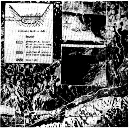
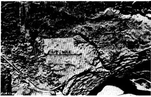
Pour déterminer la structure générale de la géologie locale, il faut tout d'abord s'adresser au bureau de l'ingénieur de la ville, On peut souvent obtenir des