THE MAASTRICHTIAN STAGE;
THE CURRENT CONCEPT
Natuurhistorisch Museum MaastrichtICentre Ckramique
6-8
September 2012
Workshop programme, abstracts and field guide
Edited by
John W.M. Jagt & Elena A. Jagt-Yazykova
Natuurhistorisch Museum Maastricht, Maastricht, the Netherlands/Uniwersytet Opolski, Opole, Poland
*
Sr
#
*
1
GO
JC\
ARNATUURHISTORISCH
MUSEUM MAASTRICHT
330
M A Y
STADSBIBUOTHEEK
MAASTRKHT
*
-
I
Some type specimens are housed at Liege University. Among the echinoids, we may cite the type of Micraster? ciplyensis Schluter, 1897, allegedly from the Maastrichtian of Ciply. In spite of our efforts, the type of Leymeriaster maestrichtensis (Schluter, 1897) (Maastricht Formation, Maastrichtian), reported by Schluter (1897) to be part of the Liege collections, has not yet been traced (see also Meijer, 1955). Also worth noting are the types of the ichnofossil Taonurus saportai Dewalque, 1881 from the 'Senonian' of northern France (Anzin).
REFERENCES
Cotteau, G., 1875. Note sur les Echinides cretaces de la province de Hainaut. Bulletin de la SociPt6 gPologique de France, (3)2 (1874): 638-660.
Dewalque, G., 1881. Fragments paleontologiques. Annales de la SociPt6 gPologique de Belgique, 8: M43-M54. Meijer, M., 1955. Sur un echinide peu connu du Maestrichtien du Limbourg hollando-belge. Hemiaster (Leymeriaster) maestrichtensis Schlueter. Natuurhistorisch Maandblad, 44: 74-77.
Mottequin, B., Coen-Aubert, M. & Poty, E., 2011. The Belgian collections of fossil Cnidaria and Porifera. In: Aretz, M., Delculee, S., Denayer, J. & Poty, E. (eds). Abstract Volume of the 11th International Symposium on Fossil Cnidaria and Porifera, Liege 2011. Kolner Forum fur Geologie und Palaontologie, 19: 111-112.
Schliiter, C., 1897. Ueber einige exocyclische Echiniden der baltischen Kreide und deren Bett. Zeitschrift der deutschen geologischen Gesellschaft. 49: 18-50.
Poster
Detailed mapping of Santonian-Maastrichtian formations in northeast
Wallonia, Belgium
Bernard ~otteauin',
Pierre thyse12, Martin
~aloux',
Jean-Marc ~ a r i o n '
& Jean-
Louis pingot3
'unite de Paleontologie animale, Universite de Liege, Allbe du 6 AoOt, 818, Sart Tilman, 8-4000 Liege 1, Belgium, email:
bmottequin@ulg.ac.be; jmmarion@ulg.ac.be; 'lnstitut royal des Sciences naturelles de Belgique, Service geologique de Belgique, Rue Jenner 13, 8-1000 Bruxelles, Belgium, email: pierre.ghysel@sciencesnaturelles.be; 3 ~ a r t h and Life Institute, Universite catholique de Louvain, place Louis Pasteur, 3, boite L4.03.06, 8-1348 Louvain-la-Neuve, Belgium, email:
Martin.LALOUX.ext@spw.waIlonie.be, jean-louis.pingot@uclouvain.be
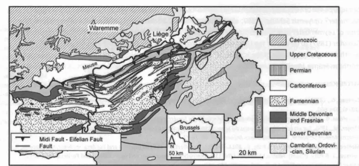
Cretaceous rocks, unconformably resting on the Palaeozoic basement, are recognised in several regions within the southern and northeastern parts of Wallonia, mainly in the Mons Basin and the Liege area, respectively (e.g., Robaszynski et al., 2002). In northeast Wallonia (Fig. l ) , Upper Cretaceous deposits essentially include sands, chalks and calcarenites. Northwest of Liege, they are generally covered by Cenozoic (Paleogene) andlor thick loess deposits. Campanian and Maastrichtian carbonate rocks (Gulpen and Maastricht formations) are still extensively quarried for the production of Portland cement in the valleys of the Meuse and Geer rivers, north of Liege. They are also excellent reservoir rocks, affected by a double porosity (Dassargues & Monjoie, 1993), and constitute the Hesbaye aquifer, which is crucial for the water supply of Liege and its suburbs.
Middle Devonian
Lower Devonian
Figure 1. Partial geological map of Belgium (modified from de Bethune, 1954, planche 8), showing the location of Upper Cretaceous deposits in northeast Wallonia.
Detailed geological mapping of the Cretaceous formations in northeast Wallonia, carried out within the context of updating of the geological map of Wallonia, is almost completed and most of the maps (at 1/25,000), dealing with Cretaceous-aged rocks, have already been published (Laloux et al., 1996a, 1996b, 2000; Barchy & Marion, 2000). Previous editions of these maps, which were published at a scale of
1/40,000, date back to the end of the nineteenth century and the beginning of the twentieth. Their revision was thus badly needed. The new geological maps of Wallonia are based exclusively on lithostratigraphy, contrary to the previous ones which were based on chronostratigraphy. They are more useful to all human activity which involves knowledge of the subsoil, such as mining, management of waste dump sites, hydrogeology and civil engineering.
The Cretaceous sedimentation recorded in northeast Wallonia spans the interval ranging from the Middle Santonian t o the Late Maastrichtian (Robaszynski et al., 2002). It was controlled by complex interactions between sea level changes and block tilting and resulted in lateral thickness and facies variations but also in numerous stratigraphic gaps (e.g., Bless et al., 1987; Bless, 1989). The mapped lithostratigraphic units (Aachen, Vaals, Gulpen and Maastricht formations) are those proposed by
elder
(1975) and Albers & Felder (1979). However, their members can only be recognised in quarries and thus, due to the general lack of significant outcrops in the major part of the area considered here, are not used for mapping.Mottequin & Marion (in press) have modified the definition of the Gulpen and Maastricht formations by transferring the Lanaye Member (calcarenites with flint nodule horizons) from the top of the Gulpen Formation t o the base of the overlying Maastricht Formation. From a lithological viewpoint, these
calcarenites are easily distinguished from the underlying chalks that constitute the major part of the Gulpen Formation and show close affinities with those of the overlying Maastricht Formation. This lithological criterion is of easy use within the context of geological mapping and clearly less subjective than a boundary based on a thin, variably developed, particular horizon, i.e., the Lichtenberg Horizon (Felder, 1975). Indeed, this horizon, which corresponds t o the craie a coprolites (Uhlenbroek, 1905), cannot be recognised
everywhere and the boundan/ between both formations, as previously defined, could be delimited only on the basis of correlations between flint nodule layers according to Felder (1988).
In central Hesbaye, south of the town of Waremme (Fig.
l),
the chalk (Gulpen Formation) i s covered by about ten metres (or more) of loess and, thus the chalk is not visible in the field. Nevertheless, the nature of the substratum is known from numerous boreholes drilled for phosphate extraction. There is, under the loess, a thick residual flint conglomerate (conglomerat a silex) (up t o 10 m thick) overlying a layer of phosphatic nodules, which attains up t o 1 m in thickness. The phosphate was extensively exploited at the end of the nineteenth century and during the Second World War (e.g., Pacyna, 2004). This explains why our knowledge of this area is better than at the end of the nineteenth century when it was first mapped. The chalks and calcarenites of the Gulpen and Maastricht formations show two periods of karstification. The first has a pre-Selandian age as karst cavities were filled by the sandy and marly deposits of the Heers Formation (middle t o late Selandian). Karst phenomena of this age are known only north of the River Geer (= River Jeker in Dutch). Karsts belonging t o the second period of karstification cover a large area of the map sheet Waremme-Momalle (Pingot, in prep.). These karsts are filled by sands of the Sint-Huibrechts- Hern Formation (Rupelian, Oligocene), which means that the Rupelian transgression was more widespread than the former which i s just preserved in karstic cavities.REFERENCES
Albers, H.J. & Felder, W.M., 1979. Litho-, Biostratigraphie und Palokologie der Oberkreide und des Alttertiars (Praobersanton- Dan/Palaozan) von Aachen-Siidlimburg (Niederlande, Deutschland, Belgien). In: Wiedman, J. (ed). Aspekte der Kreide Europas. lnternotionol Union of Geological Sciences, A6: 47-84.
Barchy, L. & Marion, J.-M., 2000. Corte geologique de Wollonie, Dolhem-Herve (42/3-4). Ministere de la Region Wallonne, Namur: 7 1 PP.
BBthune, P. de, 1954. Corte geologique de Belgique (kchelle 1/500.000). Academie royale de Belgique, Atlas de Belgique, Bruxelles, planche 8.
Bless, M.J.M., 1989. Event-induced changes in Late Cretaceous to Early Paleocene ostracode assemblages of the SE Netherlands and NE Belgium. Annoles de 10 Sociite gkologique de Belgique, 112: 19-30.
Bless, M.J.M., Felder, P.J. & Meessen, J.P.M.Th., 1987. Late Cretaceous sea level rise and inversion: their influence on the depositional environment between Aachen and Antwerp. Annoles de 10 Societk gPologique de Belgique, 109: 333-355. Dassargues, A. & Monjoie, A., 1993. Les aquiferes crayeux en Belgique. Hydrogkologie, 2: 135-145.
Felder, W.M., 1975. Lithostratigrafie van het Boven-Krijt en het Dano-Montien i n Zuid-Limburg en het aangrenzende gebied. In: Zagwijn, W.H. & Van Staalduinen, C.J. (eds). Toelichting bijgeologische overzichtkoorten van Nederlond. Rijks Geologische Dienst, Haarlem: 63-72.
Felder, W.M., 1988. Excursion A8. Lithology and stratigraphy of Upper Cretaceous of the Belgium-Dutch borderland west of the river Meuse. In: Herbosch, A. (ed.). IAS 9" Europeon region01 meeting: excursion guidebook, Leuven-Belgium, September 1988. Ministry of Economic AffairslBelgian Geological Survey, Brussels: 99-134.
Laloux, M., Dejonghe, L., Geukens, F., Ghysel, P., Hance, L., Polrot, F. & Servais,Th., 1996a. Corte geologique de Wollonie, Limbourg-Eupen (43/5-6). Ministere de la Region Wallonne, Namur: 192 pp.
Laloux, M., Dejonghe, L., Ghysel, P. & Hance, L., 1996b. Corte geologique de Wollonie, Neron-Verviers (42/7-8) (+notice explicative). Ministere de la Region Wallonne, Namur: 150 pp.
Laloux, M., Geukens, F., Ghysel, P., Hance, L. & Se~ais, Th., 2000. Corte gkologique de Wallonie, Gemmenich-Botzeloor (35/5-6), Henri-Chopelle-Roeren (43/1-2), Petergensfeld-Lommersdorf(43/3-4) (+ notice explicative). Ministere de la Region Wallonne, Namur: 95 pp.
Mottequin, B. & Marion, J.-M., i n press. Corte geologique de Wollonie, Tongeren-Herderen (34/5-6). Service public de Wallonie, Namur.
Pacyna, D., 2004. Effondrements de terrains causes par d'anciennnes exploitations souterraines de marne et de phosphate. Revue Architrave, 151: 10-12.
Pingot, J.L., in prep. Corte gkologique de Wollonie, Waremme-Momolle (41/3-4) et Heers-Borgloon (33/7-8, portie sud). Service public de Wallonie, Namur.
Robaszynski, F., Dhondt, A. & Jagt, J.W.M., 2002. Cretaceous lithostratigraphic units (Belgium). Geologica Belgico, 4 (2001): 121- 134.
Uhlenbroek, G.F., 1905. Le Sud-Est du Limbourg neerlandais. Essai geologique. Annoles de 10 SociPtk gkologique de Belgique, 32: M151-M198.