TH `
ESE
TH `
ESE
En vue de l’obtention du
DOCTORAT DE L’UNIVERSIT´
E DE TOULOUSE
D´elivr´e par : l’Universit´e Toulouse 3 Paul Sabatier (UT3 Paul Sabatier)
Pr´esent´ee et soutenue le 01/04/2015 par : Sylvain BLOCK
Évolution géodynamique du craton Ouest Africain au nord du Ghana
JURY
Philippe GONCALVES Rapporteur Membre du Jury
Kurt STÜWE Rapporteur Membre du Jury
Mark JESSELL Directeur de thèse Membre du Jury
Lenka BARATOUX Directrice de thèse Membre du Jury
Laurent AILLERES Co-directeur de thèse Membre du Jury
Jean-Franc¸ois MOYEN Examinateur Membre du Jury
Olivier
VANDERHAEGHE
Examinateur Pr´esident du Jury
´
Ecole doctorale et sp´ecialit´e :
SDU2E : Astrophysique, Sciences de l’Espace, Plan´etologie
Unit´e de Recherche :
Géosciences Environnement Toulouse
Directeur(s) de Th`ese :
Mark JESSELL, Lenka BARATOUX et Laurent AILLERES
Rapporteurs :
Cette thèse porte sur l’histoire géologique Paléoprotérozoïque du Craton Ouest Africain au nord du Ghana. La géologie régionale est présentée à l’aide de nouvelles cartes lithologique, métamorphique et structurale, produites à partir de l’interpré-tation de données géophysiques et de terrain. Le nord du Ghana est constitué de domaines granito-gneissiques, de ceintures de roches vertes de bas degré métamor-phique, et d’ortho- et paragneiss de haut grade, intrudés par plusieurs générations de granitoïdes. Ces domaines sont séparés par des chevauchements, des détachements et des décrochements formés pendant l’orogenèse Éburnéenne (2.15-2.07 Ga).
Les roches magmatiques sont issues de la série calco-alcaline ou sont analogues aux TTG archéens. La géochronologie U-Pb sur zircon indique un magmatisme continu entre 2.21 et 2.11 Ga, et livre des âges hérités jusqu’à 2.30 Ga. L’isotopie Lu-Hf indique que l’ensemble des magmas est juvénile, avec des temps de résidence crustaux de 2.45-2.30 Ga. Les caractéristiques géochimiques des roches magmatiques sont indépendantes de leurs âges. Elles suggèrent que les magmas sont issus de l’interaction et de la fusion simultanée de deux soucres : l’une mantellique, enrichie en éléments incompatibles, l’autre constituée d’une croûte basique.
Le métamorphisme Éburnéen au nord du Ghana se caractérise par une diversité des régimes thermiques. De rares reliques métamorphiques enregistrant des condi-tions à la transition entre les faciès schiste-bleu et amphibolite témoignent d’un géotherme apparent froid (HP-BT, ∼ 15˚C/km). Elles sont surimprimées par un épisode métamorphique à la transition entre les faciès amphibolite et granulite HP (20˚C/km) synchrone d’une phase de raccourcissement N-S (D1). Cette déforma-tion produit des chevauchements, un épaississement crustal et l’enfouissement de roches superficielles en base de croûte. Son âge est contraint entre 2145 et 2125 Ma par la datation de monazites métamorphiques et de zircons. La formation de détachements entre les migmatites et les ceintures de roches vertes témoigne d’un régime d’extension orientée N-S (D2). Il est interprété comme la conséquence de l’effondrement gravitaire de la pile orogénique. Les roches partiellement fondues sont exhumées au sein d’un dôme anatectique et mises en contact avec des uni-tés de faible degré métamorphique. Ensuite, une compression orientée E-O génère une déformation initialement distribuée (D3) entre 2125 et 2105 Ma, synchrone d’un métamorphisme en faciès amphibolite (25-30˚C/km) ; puis localisante (D4-D6), qui ré-active en décrochement les accidents structuraux antérieurs.
Peu après le paroxysme métamorphique vers 2130 Ma, l’évolution géodynamique se termine au nord du Ghana, alors que le magmatisme se propage et s’intensifie dans les régions plus au sud et à l’ouest. Ce diachronisme révèle l’existence de fragments continentaux distincts par leur histoire, mis en contact et stabilisés sé-quentiellement lors de l’orogenèse.
Il est proposé qu’un événement magmatique produise, à partir de 2.45 Ga et loin de toute marge active, des fragments d’une croute juvénile basique précoce, pré-curseur du Craton Ouest Africain. Ce protolithe a subi une différenciation intense jusqu’à ce que l’orogenèse Éburnéenne entraîne l’amalgamation et la stabilisation de ses différents sous-ensembles. Le nord du Ghana pourrait représenter une suture entre deux compartiments cratoniques entrés en collision. L’enregistrement structu-ral et métamorphique est similaire en certains points aux orogènes modernes, sans
dehors des périodes supposées de formation des super-continents. La géodynamique paléoprotérozoique semble unique dans l’histoire de la Terre et représente un état transitoire de son évolution séculaire, entre un régime “archaïque” et la tectonique des plaques moderne.
This thesis focuses on the Paleoproterozoic geological evolution of the West African Craton in northern Ghana. New lithological, metamorphic and structural regional maps are built from fieldwork and the interpretation of airborne geophysical data. The crust in northern Ghana comprises granite-gneiss terranes, low-grade me-tamorphic greenstone belts and high-grade ortho- and paragneissic terranes, which are intruded by successive generations of granitoids. The different litho-tectonic domains are separated by thrusts, detachments and strike-slip shear zones formed during the Eburnean orogeny (2.15-2.07 Ga).
The magmatic rocks belong to the calc-alkaline suite, or are analogue to Archean TTGs. U–Pb zircon dating reveals that magmatic activity was uninterrupted bet-ween 2.21 and 2.11 Ga, and yields inherited ages back to ca. 2.30 Ga. Lu–Hf isotope analyses show that the magmas are juvenile and derived from a source extracted from the mantle at 2.45-2.30 Ga. Their geochemical signatures do not change signi-ficantly through time, and suggest that they were generated from the interaction and coeval melting of a mafic crustal source and an incompatible element-enriched mantle source.
The Eburnean metamorphic record of northern Ghana reflects a diversity of thermal regimes. Rare metamorphic relics record conditions at the transition bet-ween blueschist and amphibolite facies that correspond to a cold apparent geo-thermal gradient (HP-LT, ∼ 15˚C/km). They are overprinted by amphibolite- to high-P granulite-facies metamorphism (20˚C/km) which developed during a phase of N-S directed shortening (D1). Contractional deformation formed thrusts, caused crustal thickening and burial of supracrustal rocks into the lower-crust. Its timing is constrained between 2145 and 2125 Ma by the dating of metamorphic monazite and zircon. Detachment faults separate migmatites from greenstone belts. They formed during N-S directed extension (D2), which is interpreted to reflect the gravitational collapse of the over-thickened crust. The partially molten lower crust is exhumed in an anatectic migmatite dome and juxtaposed to rock units of lower metamorphic grade. Subsequently, E-W directed shortening (D3) produced distributed contrac-tional strain between 2125 and 2105 Ma which is coeval with an amphibolite-facies metamorphic overprint. Strain is gradually localised (D4-D6) and older shear-zones are re-activated in a strike-slip regime.
Following the metamorphic paroxysm at ca. 2130 Ma, the geodynamic evolution terminates in northern Ghana, while magmatism propagates and intensifies in the regions to the south and west. This diachronism suggests that different crustal fragments with distinct histories were assembled and stabilised sequentially during the orogeny.
We suggest that a major magmatic event started at 2.45 Ga and produced frag-ments of juvenile, dominantly mafic crust, away from active continental margins. They formed the protolith of the West African Craton’s crust. The proto-crust un-derwent intense magmatic differentiation, until the Eburnean orogeny amalgamated and stabilised the different crustal blocs. Northern Ghana may represent a suture zone between two distinct cratonic domains that collided. Its structural and me-tamorphic record shares some similarities with modern orogenic belts, although it is not strictly identical. This work confirms that an episode of crustal growth took
unique in the history of the Earth, as they represent a transitional regime in its secular evolution, between archaic geodynamics and modern plate tectonics.
Les quelques années passées à Toulouse et ponctuées de séjours en Afrique de l’Ouest pour mener à bien ces travaux de recherche ont été pour moi un réel plaisir et une source de satisfaction personnelle. Bien évidemment, rien de tout ceci n’aurait été possible sans les nombreuses personnes qui y ont pris part et y ont contribué à leur façon, et je voudrais ici les remercier chaleureusement.
Tout d’abord, merci à toi Mark de m’avoir fait confiance aussi rapidement, à l’issue d’une brève discussion, le temps de regarder quelques données géophysiques provenant d’un coin du nord du Ghana qui avait l’air fort sympathique. J’ai pris le train du projet en marche et tu m’as permis d’y trouver ma place facilement. Merci de m’avoir donné l’opportunité de mener à bien ce travail et de voyager de conférence en mission de terrain au fil de son avancement. À propos de terrain, ces séjours laissent une quantité d’anecdotes qui sont autant de chouettes souvenirs. Promis Mark, des passages de frontières clandestins et des contre-coups des randos par 40 ˚C, rien ne filtrera !
Merci à Lenka pour ta disponibilité et ton enthousiasme qui explique que j’avais déjà quelques cailloux avec lesquels m’amuser avant même de rentrer dans le vif du sujet. Heureusement que tu étais là pour mes premiers pas dans l’univers IRD à Ouaga. Merci à vous deux pour toutes les discussions géologiques passionnantes et pour la confiance que j’ai ressenti dans votre encadrement, qui m’a permis de prendre beaucoup d’initiatives librement, autant pour établir des collaborations que sur le terrain...
Merci également à Laurent, la French Connexion en Australie, pour tes nom-breuses questions sur le terrain qui m’ont forcé à préciser mes idées et à étayer mes modèles, et pour toutes ces discussions sur nos sujets de prédilection : les plis en fourreaux et la sagduction. L’escapade à Broken Hill a été une belle expérience... le
sheath fold s’en souvient !
Cette thèse ne serait pas ce qu’elle est sans la participation de personnes qui m’ont permis d’acquérir des données et qui ont contribué à faire mûrir mes idées. Je remercie :
– Olivier Bruguier, pour avoir cassé du caillou avec nous sous un soleil de plomb, de m’avoir accueilli à Montpellier pour analyser des échantillons au laser, et de m’avoir permis de co-publier tes données acquises un peu plus tôt. Merci ! – Armin Zeh, de m’avoir acueilli à Frankfort pour des sessions de laser. Viele
danke für deine Geduld !,
– Luis Parra, à Perth, pour avoir bien voulu passer certains de mes échantillons au SHRIMP. Thank you for your help !,
– Oscar Laurent, ami de l’époque stephano - clermonto - sud-africaine. Merci pour ton aide à l’interprétation des données géochimiques !
– Jérôme Ganne pour nos nombreux échanges et réflexions communes. Ta dex-térité à la microsonde et ta profusion d’idées sur la thermicité du “WAC” ont été très appréciées et ont contribué à nourrir ces travaux.
Merci aux autres collègues du GET avec qui j’ai eu la chance de tâter du Craton Ouest Africain, Marieke van Lichtervelde, Luc Siebenaller et Mathieu Benoît. À ces
Ghanéenne nécessite patience et longueur de temps !
Je tiens à exprimer ma reconnaissance à ceux dont le travail m’a permis d’avan-cer dans mes propres chantiers, et qui m’ont transmis une part de leur connaissance ou de leur savoir-faire. Je pense en particulier à Jean-François Mena, Ludovic Men-jot et Fabienne de Parseval, fins artisans de la lame mince toujours prets à donner un coup de main, Sophy Gouy et Philippe de Parseval pour leur disponibilité et leur aide à la microsonde et à Thierry Aigouy pour son accompagnement au MEB. Pour poursuivre, je suis pleinement redevable pour le bon déroulement du travail de terrain à Kwasi Duah, chauffeur du Service Géologique du Ghana, mais égale-ment à ses heures traducteur, rafistoleur de pistes cabossées, mécano, négociant en bière de mil, vin de palme ou leurs équivalents distillés, logisticien, marchandeur de droits de passage, et recueil de bons tuyaux. Sa bienveillance m’a fait chaud au coeur et je lui en remercie. Je salue également le travail des chauffeurs de l’IRD de Ouagadougou avec qui j’ai eu l’occasion de travailler, Salifou Yougbaré, Boukary Ouedraogo et Matthieu Kaboré, qui ont apporté une joyeuse coloration à nos sé-jours, et remercie Koné Moumouni, le logisticien du projet WAXI à Ouaga, pour ses précieux coups de main. Ma reconnaissance admirative va également aux pay-sannes et paysans habitant les régions que j’ai parcouru, qui sont riches d’une grande hospitalité.
Je souhaite remercier les nombreuses personnes avec lesquelles j’ai pu avoir des discussions de géologie, à qui j’ai pu demander des avis et des informations en tout genre, en particulier les collègues du GET, Dominique Chardon, Stéphanie Du-chêne, Michèle de Saint-Blanquat, Julien Berger, Joseph Martinod, Yohan Denèle, mais aussi Max Vidal, Alain Kouamelan et les collègues jeunes géologues africains : Saga Sawadogo, Pascal Ouiya, Hamidou Waongo, Prince Amponsah, Abigail Ayik-wei et Raymond Sagna. Merci également à Stephane Perrouty, mon prédécesseur toulousain dans la région ghanéenne d’Ashanti, pour ses conseils en début de thèse, et à Helen McFarlane, qui reprend le flambeau dans la ceinture de Sefwi et qui m’a permis de m’y rendre pour avoir un aperçu de la géologie de cette région.
Enfin, je n’oublie pas Anais Brethes, Suzelle Sigo et Julie Carcone qui ont ap-porté leurs pierres à l’édifice au cours de leurs stages respectifs, ni Sabine Mélézan, qui fut d’une aide administrative précieuse.
Je remercie également les membres du jury, Philippe Goncalves, Kurt Süwe, Jean-François Moyen, Pavel Pitra et Olivier Vanderhaeghe, d’avoir bien voulu se déplacer à Toulouse pour évaluer mon travail et pour en discuter avec tant d’intérêt. Je voudrais exprimer ma gratitude envers les enseignantes et les enseignants qui ont façonné mon goût de la géologie et ma curiosité au cours de ma scolarité, aux premiers rangs desquels François Rosé, mon prof de prépa à Marcellin Berthelot, puis Pierre Thomas, Hervé Bertrand et Éva Chamorro-Perez à l’ENS Lyon. Enfin, j’adresse un remerciement tout particulier à Jean-François Moyen pour m’avoir donné l’opportunité dès le début de master de m’attaquer aux problématiques de l’Archéen en Afrique du Sud, et d’explorer des thématiques qui se retrouvent à
de ta passion pour la géologie dans le Lowveld, lors des battues aux hyènes, mais aussi sur les pentes du Pilat et dans les gorges ardèchoises. Ceci m’amène à saluer toute la “bande à Jeff” rencontrée de Stellenbosch à Saint-Etienne. Merci à Arnaud, Oscar (encore là !), Justine, Antoine, LSD, grand Simon, ptit’ Simon, Gautier et les autres pour les discussions et les bons moments de rigolade.
Je suis tout autant redevable pour la richesse de ces années de thèse aux per-sonnes rencontrées pendant cette période, aussi bien au labo qu’en dehors. En pre-mier lieu, je tiens à remercier l’équipe de choc des jeunes du GET, camarades doctorants et post-docs, pour l’environnement qu’ils ont participé à créer au labo. Un environnement souvent marqué par une atmosphère chargée d’épais nuages de gras de canard et autres effluves cullinaires, de fumées de tupperwears cramés, de vapeurs de café ou autres vins chauds. Et puis, entre ces moments de légèreté, trève de rigolade lors de nos réunions “au sommet” pour animer tout ce microcosme labo-rantin ! Merci à Alex, le roi du gras et des acronymes, pour les gueuletons et tout le reste, Sylvaine ma “marraine” de facto, Léandre, pour avoir partagé les ambiances “reggae” dans le bureau, Maria, pour nous avoir supportés tout ce temps, mais aussi JLG, Guillaume, Caro, Adrien, Damien, Arnaud, Jean, Laetitia, Thomas, Antonin, Sylvain, Brian, Cori, Van Bai, Vincent, les Fabrices, Quentin, Pierre et les autres d’avoir fait du GET bien d’avantage qu’un lieu de travail. D’autre part, la coloc’ de la Cousquille a constitué un sorte de monde parallèle, anti-thèse rafraichissant au monde du labo. J’ai une pensée affectueuse pour toutes celles et ceux qui ont fait et font vivre ce lieu, Thibaud, Laurence, Anabelle, Louis, Maeva, Lidia, Erwan, Jean, Taleb, Anne, Julie, etc. Et une pensée tendre pour Camille, que notre par-cours commun se poursuive et nous amène sur des terres propices, dans les contrées africaines comme ici.
Enfin, je tiens à remercier ma famille, du côté de laquelle mes éveils naturalistes s’enracinent. Merci à Eugène Raguin, qui m’a sans doute transmis une part de son intérêt pour la géologie, et à mes grands parents maternels qui ont assidument relayé cet héritage. Merci à mes parents pour leur soutien avant et pendant la thèse, également à mes frères et soeurs pour leur curiosité et l’ intérêt qu’ils y ont porté.
Introduction 1
Introduction générale. . . 2
Déroulement de la thèse . . . 5
Thesis development. . . 9
1 The secular evolution of the Earth 13 1.1 Introduction. . . 14
1.1.1 Historical perspective . . . 14
1.1.2 Plate tectonics today. . . 16
1.2 The Earth : a thermal machine . . . 17
1.2.1 The envelopes of the Earth . . . 17
1.2.2 Mantle convection . . . 17
1.2.3 Thermo-mechanical numerical modelling of mantle convection 18 1.2.4 The viability of subduction . . . 21
1.3 The genesis of the continents . . . 25
1.3.1 The growth and recycling of the continental crust. . . 25
1.3.2 The geodynamic sites of crustal growth . . . 27
1.3.3 Centripetal growth and terrane accretion . . . 29
1.3.4 Continental architecture . . . 29
1.3.5 Secular changes in the composition of the lithosphere. . . 32
1.3.6 Geodynamic implications . . . 37
1.4 The rheology of the lithosphere . . . 42
1.4.1 Rock rheology . . . 42
1.4.2 Rheological profiles. . . 44
1.4.3 Tectonic implications. . . 45
1.5 The secular evolution of orogens . . . 50
1.5.1 Metamorphism : investigating the thermal regime of orogens 50 1.5.2 Phanerozoic orogens . . . 50
1.5.3 Precambrian orogens . . . 58
1.5.4 Key parameters. . . 64
1.6 Synthesis . . . 64
2 The Paleoproterozoic : a transitional period ? Insights from the West African Craton. 67 2.1 The Archean - Proterozoic Transition . . . 68
2.1.1 Definition and problems . . . 68
2.1.2 Some insights into Paleoproterozoic orogens . . . 68
2.2 The West African Craton : Archaic geodynamics extending into the Paleoproterozic ? . . . 70
2.2.1 Geological setting . . . 71
2.2.2 Controversies . . . 75
3 The geology and tectonic evolution of northern Ghana 81
Introduction (en français) . . . 82
3.1 Introduction. . . 84
3.2 Lower crust exhumation during Paleoproterozoic (Eburnean) orogeny, NW Ghana, West African Craton : interplay of coe-val contractional deformation and extensional gravitational collapse. . . . 85 Abstract . . . 85 3.2.1 Introduction . . . 86 3.2.2 Geological setting . . . 88 3.2.3 Study area . . . 89 3.2.4 Mapping methodology . . . 91 3.2.5 Tectono-metamorphic history . . . 97 3.2.6 Geochronology . . . 103 3.2.7 Discussion. . . 113 3.2.8 Acknowledgements . . . 120 3.2.9 Appendix . . . 120
4 The metamorphic evolution of the West African Craton 127 Introduction (en français) . . . 128
4.1 Introduction. . . 130
4.2 Petrological and geochronological constraints on lower crust exhumation during Paleoproterozoic (Eburnean) orogeny, NW Ghana, West African craton. . . . 131
Abstract . . . 131
4.2.1 Introduction . . . 132
4.2.2 Geological background . . . 133
4.2.3 Geology of north-western Ghana . . . 137
4.2.4 Petrography and mineral chemistry. . . 138
4.2.5 Methods . . . 153
4.2.6 Results . . . 154
4.2.7 Discussion. . . 168
4.2.8 Implications for Precambrian accretionary orogens . . . 175
4.2.9 Conclusion . . . 177
4.2.10 Acknowledgements . . . 178
4.2.11 Appendix . . . 178
5 Exhumation modes on the WAC : insights from numerical mode-ling 189 Introduction (en français) . . . 190
5.1 Introduction. . . 192
5.2 Thermo-mechanical modeling of lower crust exhumation – Constraints from the metamorphic record of the Palaeopro-terozoic Eburnean orogeny, West African Craton. . . . 193
6 Crustal evolution in NW Ghana, implications for the WAC 217
Introduction (en français) . . . 218
6.1 Introduction. . . 220
6.2 Juvenile crust formation and stabilisation in the south-eastern West African Craton. Insights into post-Archean craton buil-ding processes. . . . 221
Abstract . . . 221
6.2.1 Introduction . . . 222
6.2.2 Geological setting . . . 223
6.2.3 Northern Ghana . . . 226
6.2.4 Petrography of igneous rocks . . . 227
6.2.5 Bulk-rock geochemistry . . . 228 6.2.6 Geochronology . . . 240 6.2.7 Discussion. . . 259 6.2.8 Conclusion . . . 275 6.2.9 Acknowledgements . . . 275 6.2.10 Appendix . . . 275
7 General discussion / Conclusion générale 279 7.1 Résultats et perspectives . . . 280
7.1.1 Controverses sur l’évolution du Craton Ouest Africain . . . . 280
7.1.2 Conséquences sur l’évolution séculaire de la Terre. . . 283
7.2 Main results and perspectives . . . 285
7.2.1 Controversies on the evolution of the West African Craton. . 285
7.2.2 Implications of the secular evolution of the Earth . . . 287
A Appendix 297 Livret-guide du stage de terrain - Field training course guidebook. . . 297
Introduction générale
Les sciences de la Terre s’intéressent à la formation et à l’évolution de la planète Terre, aux processus qui façonnent ses surfaces et aux interactions entre ses diffé-rents réservoirs (asthénosphère, lithosphère, hydrosphère, biosphère,...). Elles visent à développer une meilleure compréhension de la Terre, de son fonctionnement et de son histoire. Comme dans toutes les sciences, l’accumulation de données et de connaissances, au moyen de dispositifs techniques en mutation constante, s’accom-pagne de la construction de cadres théoriques servant à les interpréter. Il me semble possible d’identifier deux principaux déterminants scientifiques du cadre d’interpré-tation en vigueur actuellement au sein de la communauté des Sciences de la Terre. Le premier est l’émergence de la datation radiochronologique absolue, qui rendit possible la reconstruction, avec une confiance nouvelle, de l’histoire de la Terre. Le second est l’acceptation progressive, au début du siècle dernier, de la théorie de la dérive des continents, et l’avènement de son héritière en tant que paradigme : la tectonique des plaques.
La théorie de la tectonique des plaques permet de décrire de façon satisfaisante la dynamique de la Terre moderne. Son acceptation est telle que le terme désigne aujourd’hui non plus une théorie, mais bien le mode de fonctionnement de la Terre. La production de chaleur tellurique induit la convection du manteau. Celui-ci se différencie pour former la lithosphère, qui constitue la couche limite thermique du système convectif. La lithosphère océanique se forme en surface des courants convectifs ascendants, elle finit par entrer en subduction et plonger au niveau de courants convectifs descendants. La lithosphère continentale, elle même produite par la différentiation progressive du manteau, se déplace et se déforme en réaction à la dynamique induite par le système convectif. La tectonique des plaques désigne le mode de convection actuel du manteau terrestre, où la couche limite thermique (la lithosphère) est couplée aux cellules de convection.
Les méthodes géochronologiques ont apporté la démonstration que la lithosphère continentale s’est formée en continu au cours de l’histoire de la Terre. Certains frag-ments de continents anciens on échappé à un recyclage total et nous sont parvenus. La croûte continentale constitue donc le registre fossile observable de l’histoire de la Terre. Elle témoigne des processus géologiques et de leurs évolutions à travers les temps. Or la théorie de la tectonique des plaques a été historiquement construite en intégrant une multitude de données issues de l’observation d’objets géologiques actifs, ou du moins récents, c’est à dire essentiellement formés à l’ère Phanérozoïque (550–0 Ma), dont nous savons qu’il représente environ 13% de l’histoire de la Terre. La tectonique des plaques (en tant que cadre d’interprétation) est donc “calibrée” pour la Terre moderne.
Des décennies de recherche en sciences de la Terre ont permis de mettre en évidence d’importantes différences entre l’enregistrement géologique récent et la géologie des continents anciens. En particulier, le registre géologique des cratons datant de l’Archéen (4.0–2.5 Ga) et du Paléoprotérozoïque (2.5–1.6 Ga) suggère qu’ils se sont formés dans des contextes géodynamiques qui ne sont plus en vigueur sur la Terre actuelle, ou du moins dont nous n’observons plus d’analogues stricts. La géodynamique de la Terre primitive constitue donc un problème scientifique majeur en sciences de la Terre. La théorie de la tectonique des plaques fournit-elle
un cadre théorique transposable à l’identique à la Terre primitive ? Le mode de convection terrestre était-il le même il y a 2.5 ou 3.5 Ga ? Un certain nombre de considérations théoriques sur la thermicité de la Terre primitive nous permettent d’en douter. Dans ce cas, comment interpréter les données tirées de l’étude des cratons ? Il est sans doute nécessaire d’identifier et de caractériser les processus géologiques (pétrologie, magmatisme, tectonique) dans un premier temps, puis de conserver une liberté d’interprétation lorsqu’il s’agit de reconstituer la gamme des contextes géodynamiques dans laquelle ces processus ont pu avoir lieu.
La géologie Archéenne a fait l’objet d’études prolifiques. Les roches magma-tiques, volcaniques, métamorphiques et sédimentaires qui s’y trouvent, les res-sources minérales, les grands traits architecturaux des domaines continentaux les distinguent des continents actuels. De nombreux modèles géodynamiques ont été proposés pour expliquer leurs spécificités. Un consensus semble s’établir sur l’idée que le manteau Archéen était plus chaud qu’à l’actuel, et qu’il en découlait lo-giquement un mode de convection différent, distinct de la tectonique des plaques (Chapitre 1). Le passage d’un régime Archéen à une géodynamique moderne est situé entre 3.0 et 2.5 Ga, selon les objets d’étude. Cette transition, dont on peut discuter du caractère abrupt ou graduel, est interprétée comme étant la conséquence du refroidissement séculaire de la Terre, et de la transformation du mode de convec-tion terrestre. Elle ouvre sur le Protérozoïque, une ère géologique longue de près de 2.0 Ga dont la communauté des sciences de la Terre considère qu’elle était façonnée par la tectonique des plaques, ou du moins une sorte de tectonique des plaques similaire à la géodynamique actuelle sans être strictement identique. En effet, le re-gistre géologique du Protérozoïque présente une systématique qui rappelle la Terre moderne, bien que dans le détail les objets géologiques des deux époques puissent être différents (Chapitre1).
Cette thèse s’inscrit dans la problématique de l’évolution séculaire de la géody-namique terrestre, et se propose d’étudier un objet géologique formé au lendemain de la transition Archéen-Protérozoïque. Celle-ci est censée correspondre à la géné-ralisation, à échelle globale, d’un fonctionnement “moderne” de la Terre. L’étude se porte sur une portion du Craton Ouest Africain datant du Paléoprotérozoïque (2.25-2.10 Ga), située dans la partie septentrionale du Ghana. Elle a pour objec-tif d’explorer les mécanismes de formation du craton Ouest Africain, et des masses continentales en général, à cette époque de la Terre. Elle cherche à reconstituer l’his-toire géologique de cette région afin de formuler des hypothèses sur la géodynamique en vigueur à une période clé de l’évolution de la planète. Il est donc fréquemment fait référence aux registres géologiques de l’Archéen et du Phanérozoïque, deux périodes qui servent de modèles comparatifs pour qualifier le Paléoprotérozoïque. L’étude de cette portion du craton Ouest-Africain est traitée en prenant en compte une grande diversité de données petrologiques, métamorphiques, cartographiques, géochronologiques,... C’est pourquoi le qualificatif de “géologie générale” me semble convenir à ces travaux de thèse. Chacun des chapitres présentant les résultats de la thèse développe préférentiellement une approche et une méthode d’étude. Les cha-pitres sont rédigés en anglais, ceux qui sont présentés sous forme de publications scientifiques sont introduits par un résumé en français.
A l’échelle globale, l’évolution séculaire de la dynamique terrestre se caractérise par une métamorphose progressive des modes de déformation et des conditions
mé-tamorphiques dans les orogènes, de la composition de la croûte continentale et du type de roches qui s’y trouve, ou encore de l’architecture générale de la croûte conti-nentale. La présentation de l’évolution séculaire de la Terre est l’objet du chapitre1. Les controverses scientifiques autour de la transition Archéen - Paléoprotoérozoïque sont présentées dans le chapitre2. La géologie du craton Ouest Africain, qui fournit un précieux enregistrement du fonctionnement de la Terre à cette période charnière, et les controverses sur sa formation, sont détaillées dans ce même chapitre.
Le refroidissement de la Terre a permis la formation de lithosphères plus froides et mécaniquement plus résistantes, répondant aux contraintes par une déforma-tion cassante, un épaississement ou un amincissement localisés, plutôt que par un fluage distribué. Le chapitre 3est consacré à l’étude du mode de déformation de la croûte du Craton Ouest Africain pendant l’orogenèse Éburnéenne (2.15-2.10 Ga). Il fournit des données permettant de discuter de la rhéologie de la croûte juvénile Paléoprotérozoïque du nord du Ghana.
Les types de déformation, la capacité de la croûte à s’épaissir ou à fluer sous la contrainte et le régime thermique de la croûte déterminent la nature des roches mé-tamorphiques qui s’y forment et y sont préservées pendant une orogenèse. L’histoire de la Terre témoigne de l’apparition d’une dualité de régimes thermiques à partir du Paléoprotérozoïque, et d’un refroidissement progressif des géothermes fossiles. Le chapitre4présente une étude complète de l’évolution métamorphique des unités géologiques du nord du Ghana, et compare les associations métamorphiques qui s’y trouvent à celles des orogènes plus anciens et plus récents.
La modélisation numérique permet de tester des hypothèses concernant le mode de déformation et le régime thermique d’une croûte ou d’une lithosphère théorique. Le chapitre 5 présente une étude de modélisation thermo-mécanique et thermody-namique qui teste la capacité d’un régime tectonique donné (raccourcissement 2D) à reproduire l’enregistrement métamorphique du Craton Ouest Africain, en parti-culier à exhumer des roches métamorphisées dans la croûte moyenne ou inférieure. La croûte Archéenne est essentiellement constituée de “gneiss gris”, dont la plus grande proportion est dérivée de roches magmatiques appartenant à la série des TTGs (tonalites, trondhjemites, granodiorites). Ces roches sont quasiment ab-sentes des continents plus récents, dont les granites représentent la lithologie la plus fréquente. La transformation du magmatisme continental au cours de l’histoire de la Terre reflète un changement dans les sources des magmas crustaux et dans les processus pétrogénétiques qui les produisent. Le chapitre6s’intéresse à la géochimie des roches magmatiques paléoprotérozoïques présentes au nord du Ghana, pour ten-ter d’identifier la source du magmatisme et les processus qui le contrôlent. L’étude géochimique est couplée à une étude géochronologique, afin de reconstituer l’his-toire de la production, de la maturation et de la stabilisation de la croûte juvénile. Ces informations sont ensuite utilisées pour envisager les contextes géodynamiques potentiels dans lesquels la croute continentale du nord du Ghana, et à plus grande échelle, du craton paléoprotérozoïque, s’est formée.
Le chapitre7synthétise les principaux résultats et aborde quelques perspectives de recherche ouvertes par ces travaux.
Déroulement de la thèse
Cette thèse se déroule dans le cadre de l’Initiative d’Exploration en Afrique de l’Ouest (IXAO/WAXI). Il s’agit d’un projet de recherche qui développe une collabo-ration entre des universités et des services géologiques de pays d’Afrique de l’Ouest, des instituts de recherche de pays occidentaux (principalement l’Australie, la France et la République Tchèque) et de l’Afrique du Sud, et des compagnies de l’industrie minière actives en Afrique de l’Ouest. Le projet WAXI a pour objectifs de stimu-ler la recherche scientifique en Afrique de l’Ouest afin d’accroître les connaissances géologiques générales sur le Craton Ouest Africain, de former et transmettre des compétences aux étudiants, universitaires, personnels administratifs et employés du secteur minier ouest-africains, et de répondre aux demandes de compagnies minières en matière scientifique. Les zones d’études du projet sont choisies en fonction des collaborations scientifiques établies, de la situation politique et de la disponibilité de données géologiques gouvernementales ou industrielles.
La thèse a été financée par une bourse du Ministère de l’Enseignement Supérieur et de la Reecherche français. Les frais de recherche ont été pris en charge par le projet WAXI, dans son second cycle (WAXI II), à partir de septembre 2011. A cette époque, l’équipe WAXI a déjà entrepris des travaux de recherche au sud du Mali, sud du Ghana, sud-ouest et nord du Burkina Faso, qui sont en cours ou sont achevés. Le nord du Ghana se situe alors entre différentes régions ayant déjà fait l’objet d’une étude géologique et cartographique. De plus, l’équipe WAXI a construit un réseau de collaborations performant avec des collègues ghanéens et burkinabés. Enfin, depuis la fin des années 2000, le gouvernement ghanéen dispose de données géophysiques aéroportées de bonne qualité sur son territoire, et quelques publications récentes suggèrent que la géologie du nord du Ghana a un potentiel scientifique important. Dans ces circonstances, un nouveau projet de recherche y est lancé.
Initialement, la formulation du sujet de la thèse laisse volontairement une li-berté dans le choix des aspects à explorer en détail : “L’évolution géodynamique de la ceinture paléoprotérozoïque de Bolé-Nangodi, nord du Ghana, Craton Ouest Africain”. L’objectif étant de contraindre l’histoire géologique générale de la zone d’étude. Dans un premier temps, la priorité est de produire une nouvelle carte géolo-gique du nord du Ghana à partir de l’interprétation des données géophysiques et de données cartographiques de terrain, en suivant les méthodes utilisées lors d’autres travaux de l’équipe WAXI. L’état des connaissances disponibles sur le craton semble souffrir d’une carence de données métamorphiques couplées à des contraintes géo-chronologiques et structurales. Compte-tenu de la présence reconnue de roches mé-tamorphiques qui se prêtent aux études thermo-barométriques dans la région, il est pertinent de développer le volet métamorphique pour étudier la géologie régionale. Pendant le travail de terrain, l’échantillonnage porte sur tous types de roches, afin d’avoir la possibilité d’étudier d’autres aspects de l’histoire géologique. Ainsi, à un stade plus avancé de la thèse, l’étude géochimique et géochronologique des roches magmatiques est intégrée aux travaux, en collaboration avec de nombreux collègues.
Sites d’affleurements étudiés en 2012 (jaune) et 2013 (bleu). / Localisation of out-crop sites visited in 2012 (yellow) and 2013 (blue). Carte / Map 1 :1 000 000Duodu (2009)
Travail de terrain
Le nord du Ghana - informations utiles
La zone d’étude s’étend depuis la frontière entre le Togo et le Ghana à l’est, le long de la frontière septentrionale du Ghana, jusqu’au centre-ouest du pays, dans la région frontalière de la Côte d’Ivoire à l’ouest. Elle inclut les régions ghanéennes “Upper East” et “Upper West”, ainsi que le tiers occidental de la “Northern region”. Cette aire géographique correspond à l’ensemble du socle paléoprotérozoïque au nord de la ville de Banda-Nkwanta. Quelques observations de terrain sont également effectuées dans les zones limitrophes au sud du Burkina Faso, dans la région de Gaoua et Batié, ainsi qu’au au nord-est de la Côte d’Ivoire.
Ces régions se trouvent dans la zone climatique Soudano-Guinéenne. Celle-ci se caractérise par un régime de mousson entre avril et septembre, une saison sèche le reste de l’année, et un fort gradient S-N de pluviométrie. Le couvert végétal naturel consiste en une savanne arborée ou une forêt sèche, dont les kaicedras, les karités et, au nord, les baobabs sont emblématiques. Les hautes herbes sèches sont mises à
feu dès novembre, ce qui facilite la progression dans la savanne entre décembre et avril. Les températures sont maximales en mars-avril.
La topographie du nord du Ghana est faible et l’altitude de 200-400m environ. Les points hauts topographiques correspondent à des buttes témoin d’un plateau latéritique dont les fragments sont distribués sur l’ensemble de la région. Les col-lines latéritiques dominent des plaines alluviales et des coteaux à la topographie très douce. Le socle paléoprotérozoïque y affleure de manière discontinue. Les af-fleurements sont principalement situés dans le lit des cours d’eau ou sur les coteaux, au niveau de changements de pente à l’approche d’un cours d’eau ou de la limite du plateau latéritique. Des granitoïdes forment d’occasionels inselbergs. Les quartzites et les conglomérats du bassin de la Volta, datant du Néoprotérozoïque et déposé en discordance sur le craton, forment des crêtes qui culminent jusqu’à une centaine de mètres au dessus de la plaine.
L’agriculture est la principale activité économique de la région. L’igname, le maïs, le manioc, le pois et le sorgho sont cultivés de façon extensive sur brûlis. Les collines latéritiques sont relativement densément boisées car elles ne sont pas arables. L’activité agricole se concentre en saison humide. En Côte d’Ivoire, et dans une moindre mesure au Ghana, de grandes surfaces sont utilisées pour la culture de mangue et de noix de cajou, mais elles sont ouvertes d’accès. Au Ghana, l’abattage d’arbres pour la production de bois d’œuvre ou de charbon de bois a grandement endommagé la forêt. Récemment, l’extraction artisanale d’or (“Galamsey”) a pris d’importantes proportions. Des campements temporaires regroupant des milliers de personnes s’installent sur ces sites. L’orpaillage est officiellement illégal au Ghana, mais il est apparemment lucratif. De ce fait, il est préférable de se présenter à l’entrée des sites d’extraction. La densité de population est faible, les rencontres avec les cultivateurs, chasseurs et éleveurs semi nomades sont fréquentes sur le terrain. De nombreuses langues différentes sont parlées dans le nord du Ghana, parmi lesquelles le Gonja (région de Bolé) et le Dagaari (région de Wa).
Les modes d’usage des terres impactent la façon d’organiser le travail de terrain. La période la plus appropriée est entre décembre et mars. La savanne est parcou-rue par de nombreux chemins, en particulier le long des cours d’eau. Des pistes carrossables sont régulièrement ouvertes par les orpailleurs, les cultivateurs et les charbonniers.
Campagnes de terrain
La majorité du travail de terrain a lieu lors des saisons 2012 et 2013, entre jan-vier et mars. En 2012, un première mission de terrain de 3 mois a pour objectif d’acquérir une vision d’ensemble de la géologie et de l’organisation des différents domaines structuraux. Tous les principaux types de roches sont échantillonnés. Des données structurales préliminaires permettent de formuler des hypothèses sur l’his-toire géologique de la région. L’année suivante (3 mois), l’étude se concentre sur les domaines poly-déformés les plus complexes situés au nord-ouest du Ghana, afin de tester les hypothèses issues du travail de l’année précédente. Les relations de terrain sont étudiées en détail, en particulier à pied le long de profils pour établir des coupes géologiques. Des travaux de reconnaissance ont également lieu au sud du Burkina Faso et au nord-est de la Côte d’Ivoire, de part et d’autre du Mou-Houn. En 2014 une formation de terrain axée sur la géologie métamorphique et structurale
est organisée pendant 7 jours dans la zone d’étude. Le livret guide bilingue rédigé à cette occasion est fourni en annexe de la thèse. La formation est déstinée aux étu-diants d’université et de personnels des services géologiques et de l’industrie (voir le document en annexe). Elle réunit une douzaine de participants, plus une dizaines de collaborateurs (chauffeurs, aides logistique,...). Le séjour sur place dure environ deux mois et permet également d’effectuer des observations complémentaires sur la zone d’étude et dans les régions avoisinantes.
Au total, 963 sites d’affleurements sont décrits et référencés dans une base de donnée. Les informations collectées à chaque affleurement comprennent des don-nées lithologiques, pétrologiques et structurales, ainsi que des photographies et des mesures de susceptibilité magnétique. Environ 330 échantillons ont été collectés sur 250 sites.
Thesis development
Scientific context of the thesis
The work presented in this thesis was carried out in the framework of the West African Exploration Initiative (WAXI) project. This project is a collaboration bet-ween West African universities and geological surveys, research institutions from a few western countries (mainly Australia, France and the Czech Republic) and South Africa, and companies of the mining industry that are active in West Africa. It is mainly funded by industry participants. Its objectives are to enhance research in West Africa to increase the general geological knowledge of the West African Cra-ton, to train and transfer capacities to the West African students and university staff, administrations and companies, and to adress some of the scientific demands of exploration and mining companies working in West Africa. Target study areas of the project are selected depending on the working collaborations, political situation, government and industry data availability at a given time.
This thesis was funded by scholarship of the French research ministry, while research costs were partially covered by the WAXI project. It started in the sixth year of the WAXI project, in september 2011. At this time, significant research work was carried out by the WAXI team and its collaborators in southern Mali, southern Ghana, south-western and northern Burkina Faso. Northern Ghana is lo-cated in between a few previously studied areas. Furthermore, the WAXI team had build high-quality collaborations with Ghanean and Burkinabe collaborators. Fi-nally, good quality geophysical data was available for northern Ghana, and previous work suggested that this area held interesting geological, architectural and meta-morphic features. All these reasons incited the beginning of a new research project in northern Ghana.
The initial objectives of this thesis were voluntarily loosely formulated : “The geodynamic evolution of the Paleoproterozoic Bole-Nangodi belt, northern Ghana, West African Craton”. This wide definition allowed the possibility to carry out in-vestigations in various directions in order to produce a general geological framework of the study area. Two objectives were specifically envisaged. The first one was to produce a geological map of northern Ghana based on the interpretation of airborne geophysical datasets and on field mapping, similar to what had been produced by other members of the WAXI team. Secondly, there was a strong incentive to carry out an in-depth metamorphic study, because the use of metamorphism to constrain the evolution of the West African was limited compared to other cratonic provinces. Launching a field study in northern Ghana was also an occasion to enrich the geo-chronological and geochemical database that the WAXI project was progressively building.
Field work
Useful information on northern Ghana
The study area extends from the vicinity of the junction between the Togo-Ghana and Burkina Faso - Togo-Ghana international borders to the northeast, along the northern border with Burkina Faso, and down to central-western Ghana, in the region bordering Côte d’Ivoire. It includes all of the Upper East and Upper West
Savanne arborée du nord du Ghana. / Wooded savannah of northern Ghana.
regions, along with the western third of the Northern region. This corresponds to all of the exposed Paleoproterozoic basement to the north of Banda-Nkwanta town. Reconnaissance field work was also carried out in the border region of southern Burkina Faso, near to Gaoua and Batie towns, and in north-eastern Côte d’Ivoire, in the area of Bouna town. The investigated area corresponds to the south-central part of the Sudano-Guinean climate zone. It is characterised by a monsoon rainfall regime between April and September, a dry climate for the rest of the year, and a strong S-N annual rainfall gradient. The area is naturally covered by an open dry forest savannah. Kaicedras, shea butter trees and, to the north, baobabs are emblematic specimens of the region flora. The biomass burning seasons starts in November, and large land surfaces are clear of the seasonal vegetation cover between December and April. Temperatures are at their highest in March and April.
Northern Ghana has very little topography, and lies on average at 200-400 m altitude. Topographic highs are formed by a dismembered laterite (“duricrust”) plateau. It forms hills that dominate over vast plains, stream beds and floodplains, where the Paleoproterozoic basement crops out discontinuously. Basement outcrops are mostly found in riverbeds, at a change of slope when approaching riverbeds or laterite hills, or as granitic inselbergs. The quartzites and conglomerates of the Neoproterozoic Volta basin form ridges up to a hundred meters high above the plain.
Traditional human activities are mostly agricultural. The dominant agricultural practice consist of “slash and burn” extensive farming. Farmers mainly grow beans, maize, sorghum, cassava and yam. Duricrust hills are most thickly wooded because of the absence of soil which renders them unsuitable for farming. Farming is mostly restricted to the wet season. In Côte d’Ivoire and to a lesser extent, in Ghana, large
land surfaces are used for cashew nut and mango plantations, and they are open to fieldwork. In Ghana, logging and charcoal export have greatly damaged the forest. Recently, artisanal gold mining (“Galamsey”) has boomed to an impressive scale. Temporary towns of a few thousand people settle on the sites of mineable gold deposits. Officially, Galamsey is illegal in Ghana, but it is apparently highly profi-table. This reality always makes it a bit delicate to enter a Galamsey site without any warning. Population density is low and grassland is extensive, which makes it a favourable land for cattle herding by semi-nomadic peoples (Furanis). Northern Ghana has multiple languages, among which Gonja (Bole area) and Dagaari (Wa area).
The land use impacts the way fieldwork is organised. The most appropriate period for fieldwork is between December and March. Footpaths and cattle paths are plentiful, especially parallel to river beds. Vehicle tracks in the savannah are regularly cleared by artisanal miners, farmers and charcoal traders.
Field campaigns
Most of the field work was carried out during the 2012 and 2013 field seasons, between January and March. In 2012, reconnaissance field work aimed at providing a large-scale view of the geology and the spatial organisation of the various tectonic domains. All of the principal rock-types were sampled. Preliminary structural data allowed to formulate hypotheses on the geological history. The 2013 field season focused on the most complex, poly-deformed geological units found in the north-western part of Ghana, where the hypotheses drawn from the previous field season were tested. Field relationships were studied in detail, mainly on foot along cross-sections. Reconnaissance field work was done in southern Burkina Faso and north-eastern Côte d’Ivoire, across the Black Volta river from north-western Ghana. In 2014, a field training course on structural and metamorphic geology was organised in the study area. The field guidebook is presented in the appendix of the thesis. The training course was run with a dozen participants, including university students and lecturers, staff from geological surveys and from mining companies, and about ten aides (drivers, etc). During the two-months stay in 2014, complementary field observations were carried out in the study area and in the neighbouring regions.
A total of 963 outcrop localities were described and referenced in a database. Data collected at each outcrop site systematically included lithological, petrologi-cal and structural information, and occasionally comprised photographs, magnetic susceptibility readings. About 330 rock samples were collected from 250 outcrop localities.
The secular evolution of the
Earth
1.1
Introduction
1.1.1 Historical perspective
Alfred Wegener formulates the theory of contiental drift in 1912 (Wegener, 1912). His theory is based on the shape complementarity of continents (particu-larly on either sides of the Atlantic ocean) and on geological and paleontological correlations from one continent to another. Additionally, his work stems from mul-tiple earlier scientific findings and from advances in geophysics during the XVIII and XIXthcenturies. Indeed, in 1749 Bouguer reports measures of gravity anomalies in the vicinity of topographic relief in the Andes which he interprets as originating from spatial variations in continental mass distribution (Bouguer, 1749). Decades later, Boscovich, followed by Airy (Airy,1855), interpret these findings as the re-sult of a “compensation” between masses in an upper compartment, the “sial”, and in a lower, denser viscous layer, the “sima”. This compensation of lateral den-sity gradients is termed isostasy. In 1915, Barrell identifies the lower viscous fluid layer as the asthenosphere, and distinguishes it from the superficial and rigid li-thosphere (Barrell, 1915). At the end of the XIXth century, the pioneer work of Bertrand in the Alps describes large-scale thrusts (“nappes de charriage”) which provide evidence for major lateral bulk contraction and for horizontal stresses in orogens (Bertrand, 1892). Finally, Haug notices in 1900 that deformation on the Earth surface is localised in “belts” delineating contiental domains (Haug, 1900). In this scientific environment, Wegener claims that the theory of “continental brid-ges”, supposedly linking continents together in the past and presently submerged below sea level, cannot be reconciled with the concept of isostatic equilibrium, and is therefore invalid. His intuition probably arises from the study of glaciology and ice caps. Continents behave like icebergs colliding and fragmenting while drifting in a denser viscous fluid. His theory is derived from empirical observations, but it bears some approximations and it lacks a convincing theoretical demonstration. The distinction between continents and lithosphere is unclear, and the causal re-lationships are obscur. Although the forces driving continental drift are unknown, his understanding of the rheological behaviour of the Earth is sufficient for him to formulate accurately the problem.
All that can be asserted is that the Earth behaves, relative to short-period forces such as seismic waves, as a solid, elastic body ; and fluidity does not intervene in this case. However, when long-period forces are concerned and exerted over geological times, the Earth behaves as a fluid, as shown, for example, by its flattening which matches exactly its rotation period. Anyhow, if we were to determine the period over which deformation becomes fluid after being elastic, we would need to know the viscosity (Translated from french) (Wegener,2012).
Wegener’s theory challenges the dominant intellectual framework which served to interpret geological observations at his time, and fuels intense debate. Meanwhile, the community’s understanding of the thermal structure of the Earth is improving. Radioactive decay is identified as a heat source, and questions are raised on the mechanisms of planetary heat transfer and dissipation. Convection is envisaged as a plausible mechanism. In 1921, Bull postulates a link between heat loss and continental drift. He suggests that convective flow may drive continental drift and provoke continent dislocation.
Another hypothesis claims that sufficient strength to cause the displacement of large parts of the crust may be provided by convective movements in the material directly underlying the crust. If, for any reason, movements occurred below the crust and exerted a sufficient friction, many things would be explained. The dislocation of permo-carboniferous Gondwanaland, leaving Africa in the center, India drifting to the north east, Australia to the east, Antarctica to the south east and South America to the west, suggests the rise of a convective flow below Africa, and its horizontal displacement below the crust of the Pacific. The circulation of such a flow below the thin oceanic crust would push on continental masses with deeper keels and displace them away (Translated from french) (Bull,1927).
At the beginning of the 1930’s, Holmes supports the theories of Wegener and Bull, as they seem to lay a fertile basis to explore heat loss processes (Holmes,1931). He contributes to understanding the interactions between geology and the thermal structure of a convective Earth, and focuses his attention on geological processes behind heat and density gradients, such as phase transitions, metamorphism and magmatism. The scientific debate shifts on possible mechanical coupling between sial and sima, and crystallises on the rheological properties of the asthenosphere. One school of thought, represented by Jeffreys, considers that horizontal forces ap-plied to continents are too weak to cause displacements, and that the asthenosphere is too strong to deform plastically (Jeffreys,1926). Supporters of Wegener’s theory argue that the asthenosphere may have a plastic behaviour whatever the intensity of boundary forces. This period also witnesses an increase in analytical and ana-logue modelling studies. The result of anaana-logue modelling performed by Griggs sug-gest that there is a possible interaction between convection and orogenesis (Griggs, 1939). The idea of a mechanical coupling between different planetary envelopes is a subject of growing attention. Meinesz recognises a cyclicity in the planetary tectonic activity and, based on the wavelength of measured gravity anomalies, proposes the existence of two superimposed and intermittent convective systems with distinct wavelengths.
The acceptability of the emerging plate tectonics theory remains a challenge because of the lack of knowledge on the rheology of the Earth, or on the implications of mantle heterogeneities on convection. Many consider this theory with suspicion because of the difficulty to test it accurately, as stated by Goguel in 1952 : Because
of its flexibility, the convection hypothesis does not seem prone to establish precise rules on the position of orogenic zones or on their time distribution. On the contrary, geological analysis ought to provide us with information on the history of convection flows (Translated from french) (Goguel,1965).
The exploration of sea-floor geology one decade later finally provides new deter-mining scientific facts. The demonstration of the existence of sea-floor spreading and mid-oceanic ridges provides, for the first time, a visible result of convection. Hess argues for a mechanical coupling between lithosphere and asthenosphere, and sug-gests that mid-oceanic ridges mark the emplacement of upwelling convective flows accounting for surface heat loss, while trenches represent downwards flows (Hess, 1962). In the following years, the plate tectonics theory becomes widely accepted by the Earth Sciences community. Nevertheless, it gains precision as the understanding of the Earth dynamics improves. In this sense, the role of subduction in maintaining convection, and the viability of plate tectonics on the early Earth remain matters
of research today.
1.1.2 Plate tectonics today
The plate tectonics theory postulates that the Earth lithosphere is divided into independent rigid mobile plates. Mantle convection and asthenosphere - lithosphere interactions are responsible for plate motion. Lithospheric plates deform along their active margins, which may be convergent or divergent. Plate dynamics control conti-nental Wilson cycles, collision and rifting. The plate tectonics paradigm is an effi-cient theoretical framework to interpret general geological observations. Its present acceptance is such that the term “plate tectonics” does not strictly designate the scientific theory any more, it is also used to refer to the thermal regime and to the geodynamic setting of the modern-day Earth. The plate tectonics theory benefits from constant refinement due to improvements in our understanding of the Earth dynamics, particularly as a result of ever-growing technological and analytical ca-pacities. It remains an active research topic today. The initiation of subduction is a process which is debated. Deviations to the plate tectonics framework (e.g. intra-plate deformation) are topical. The evolution of intra-plate tectonics through the Earth history, and its viability on the early Earth, generated a prolific literature.
The brief historical perspective recalled above shows that the plate tectonics theory rose from multiple convergent data collected from modern geological objects. The Phanerozoic geological record (0–550 Ma) played a historical role in building most ideas and defining processes in Earth Sciences. It is therefore unsurprising that the older (Precambrian) Earth is less well understood. Interpreting geological data from old domains is a long running scientific problem. Firstly, ancient geological provinces are tectonically inactive, so geologists are left to study objects “frozen” in their final evolutionary states. Secondly, the applicability of the plate tectonics framework raises questions. Has the thermal regime of the Earth changed since the formation of the planet ? Did the Earth follow a linear evolution, or stepwise transitions ? Are geological processes time-invariant ? The reliability of an unifor-mitarian reasoning, which postulates that the plate tectonics paradigm is valid for the interpretation of past geological record (Windley,1993), is a matter of debate. Exploring this scientific question requires a holistic approach of Earth Sciences, taking into account the many interactions and causal links between the geological phenomena which together form “geodynamics”. In this chapter, I aim to give a broad coverage of the diversity of complementary methods which are used to inves-tigate the geodynamic evolution of the Earth in its early days. Thermo-mechanical numerical modelling provides a tool to study possible convection modes for hotter thermal conditions, as inferred for the early Earth. Some important results are pre-sented in part 1.2. The continental crust is the fossil record of the Earth. Secular evolution trends of the composition of the continental crust, along with continent growth models calibrated on isotopic studies, are discussed in part 1.3. Part1.4 fo-cuses on the implications of hotter thermal regimes on the rheology, strain patterns and tectonic styles of the lithosphere. The rock record of Phanerozoic and Precam-brian orogens are compared in part 1.5. They represent field evidence for secular changes in orogenic belt, which may be related to general geodynamic transitions during the Earth history.
1.2
The Earth : a thermal machine
1.2.1 The envelopes of the Earth
Planet Earth is made of concentric envelopes with decreasing density outwards. The kernel is made of siderophile elements, essentially iron and nickel. It comprises an inner solid core and an outer liquid envelope. The kernel is separated from the mantle by a transition zone (D”). The mantle is made of lithophile elements (do-minantly Si, Al, Mg, Fe and O) and its principal mineral phase is olivine. Mantle density decreases with depth across pressure-dependant phase transitions (at about 660 and 440 km depth). The crust - oceanic or continental - overlies the mantle. Mantle magmatism and differentiation continuously produced crust through geo-logical times. The outer fluid envelopes of the Earth are the hydrosphere and the atmosphere, which host the biosphere. The various envelopes of the Planet are lin-ked by heat and mass transfers, in such a way that the secular evolution of the Earth is recorded by physical and chemical changes within each of them.
The lithosphere is the outer envelope of the solid Earth. It is made of the crust and the lithospheric mantle, which are separated by a petrological limit : the Moho-rovicic discontinuity (MOHO). The continental lithosphere has an average thickness of 100–200 km and is mostly emerged above sea level. It comprises a continental crust, andesitic in composition, about 40 km thick. The oceanic lithosphere is 0–80 km thick, including a 0–10 km crust. The asthenosphere is the mantle layer un-derlying the lithosphere. The boundary between lithosphere and asthenosphere is a rheological transition occurring at around 1300˚C, at conditions where asthenos-phere peridotites are mechanically weak, due to the presence of a small proportion of interstitial melt.
1.2.2 Mantle convection
The internal heat of the Earth emanates from two sources : heat production from radioactive isotope disintegration, and heat inherited from the formation of the Planet by accretion of chondritic material (e.g. latent heat of crystallisation of the kernel). Heat is lost through the asthenosphere via convective flow, and through the lithosphere via conduction and magmatism. The lithosphere represents the thermal boundary layer of the mantle-scale convective system. Surface heat loss is materialised by a measurable heat flux. Mantle convection impacts and controls lithospheric geodynamic processes. “Plate tectonics” represents a convection style where the thermal boundary layer (the lithosphere) is chemically and rheologically heterogeneous and distinct from the convective mantle. The thermal boundary layer is extracted from the asthenosphere through magmatic processes. The oceanic li-thosphere, formed at mid-oceanic ridges, cools down with time, getting thicker and denser, until it becomes negatively buoyant relative to the underlying asthenos-phere. The density inversion causes the lithosphere to sink, forming subduction zones. Therefore, the plate tectonics regime is characterised by a thermal boundary layer which is actively advected into the asthenosphere, and which provides the driving force of horizontal plate motion and deformation (Fig.1.1).
Consequently, the lithosphere has some retro-control on the convection style and the efficiency of heat dissipation. Most heat loss occurs at mid-oceanic ridges, where
convective flows rise, hence the Earth cooling rate is dependent on ridge distribution, ocean spreading and subduction velocities. Subduction velocity in turns is deter-mined by the physico-chemical properties of the lithosphere, themselves dependent on lithosphere formation processes and mantle temperatures. Understanding the Earth geodynamics and its secular evolution requires considering the causal links and feedbacks between thermo-mechanical, chemical and petrological processes in the lithosphere and at the interface with the asthenosphere.
Figure 1.1: Simplified sketch of mantle convection on the modern Earth (http ://planet-terre.ens-lyon.fr).
1.2.3 Thermo-mechanical numerical modelling of mantle
convec-tion
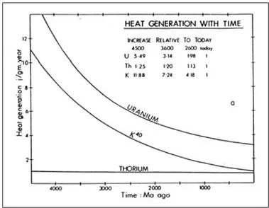
The Earth formed by the accretion of chondritic material in a proto-planetary nebula, which evolved from a supernova at the origin of the solar system. Nucleo-synthesis in the supernova formed radioactive isotopes. The isotopes responsible for most of the radiogenic heat produced presently are 235U, 238U, 40K, 232Th (Fig. 1.2), and their concentrations have decreased significantly since the formation of the Earth. This implies that the average mantle temperature of the primitive Earth must have been higher in the past, and that the planet gradually cooled down throughout geological time (Abbott et al.,1994;Labrosse and Jaupart,2007). Nu-merical modelling has been widely used to explore the possible consequences of higher mantle temperatures on terrestrial geodynamics.
Parametrised convection models have been used to model the mantle dynamics through time (Richter,1985;Schubert et al.,1980;Turcotte,1980). They served as a theoretical basis for numerous geodynamic scenarios proposed for the early Earth. These models consider the convective mantle as a “classical” convective system (as water in a saucepan heated from below), for which the heat loss flux Q(t) is propor-tional to internal temperature. Integration in time of the heat balance equation of
Figure 1.2: Evolution of the radiogenic heat production of the Earth with time. The decrease follows the desintegration curve of the main radioactive isotopes in the Earth mantle and crust (Lambert,1976).
the Earth with a classical parametrisation of Q(t) leads to a “thermal catastrophe” : the mantle potential temperature (Tpot) reaches unrealistically high temperatures. Indeed, an increased mantle temperature means increased heat loss, which requires even higher primitive mantle temperature in order to fit present day temperature conditions. Reconciling the results of these models with petrological constrains re-quires invoking stratified convection, or enhanced radiogenic heat production on the early Earth, both of which are not supported by complementary datasets. In any case, results from this type of model suggest a more vigorous convection for hotter mantle temperatures, and inspired geodynamic models with multiple small lithospheric plates and high total ocean ridge lengths to evacuate an elevated heat flux (Abbott and Menke,1990;Hargraves,1986;Nisbet and Fowler,1983).
Korenaga(2006) models mantle convection for the early Earth using a different parametrisation method. The lithosphere thickness is controlled by dehydration and partial melting processes, and by thermal erosion, all of which are dependant on mantle temperature. Figure 1.3 shows the relationship between the thickness of the thermal boundary layer and mantle temperature. The thickness is minimal for thermal conditions which are similar to the modern-day thermal regime, while it increases with increasing mantle temperature as a consequence of enhanced chemical differentiation of the lithosphere. The heat flux Q is calculated from the energy balance of the thermal boundary layer (i.e. the oceanic crust), which depends on its thickness and its composition. Q is proportional to the plate velocity U. The model ofKorenaga(2006) is therefore based on the energetics of plate tectonics. It predicts a less vigorous convection and a reduced heat evacuation “efficiency” for higher mantle temperatures. The maximal plate velocity is obtained for a minimal lithosphere thickness, i.e. in conditions similar to those prevailing on the modern Earth. This setting allows a more efficient heat evacuation, which is expressed as the Urey ratio :
Figure 1.3: Modified from Korenaga(2006). (a) Ocenanic lithosphere thickness as a function of the mantle potential temperature. The black curve is the net result of different processes with opposing effects on lithospheric thickness. Decreasing rock viscosity with increasing temperature implies a thinner lithosphere (grey curve). The effect of higher temperatures on viscosity is counter-balanced. A hotter mantle implies higher partial melting rates and melting in a thicker mantle layer. This in turns causes enhanced dehydration and chemical differentiation of the lithosphere, and an increase in the lithospheric strength (dashed curve).
Figure 1.3: (b-e) Results presented by Korenaga(2006) are obtained for different values for Ur (= γ). γ is constrained by different methods, which produce a range of values represented by the shaded zone between bold black curves. The results are compared with those of conventional parametrised convection modelling. (b) Mantle temperature as a functon of time. Values are within the range constrained by petrology. (c) Average plate kinematics vs time, showing decreasing velocities back through time, and a maximal velocity in the Phanerozoic. (d) Internal heat production (H) and outwards heat flux (Q) vs time (e) Corresponding Urey ratio showing an increasing cooling efficiency with time. (f ) Average plate velocity com-pared to the episodic assembly of super-continents, which is considered to reflect the characteristic period of ocean closing.
with H and Q respectively mantle heat production and mantle heat flux across the thermal boundary layer. The Urey ratio increases back in time as mantle tempera-ture rises, suggesting less efficient cooling and more sluggish plate tectonics in the Paleoproterozoic and Neoarchean.
Additionally,Labrosse and Jaupart(2007) take into account the changing struc-ture of the lithosphere with age, which requires to model the age distribution of the oceanic lithosphere in order to calculate the thermal regime of the Earth. On the modern Earth, the probability for a fragment of oceanic lithosphere to be subducted is independent from its age due to the spatial competition between different ridge-subduction systems, and its maximum age is about 180 Ma. On the early Earth, the authors suggest - based on theoretical arguments - that the maximal age of the oceanic lithosphere may be smaller. They use an average age distribution integrated over the course of a Wilson cycle, and take into account a model for the growth of the continental lithosphere, and its impact on the thermal budget of the mantle. Modelling results (Fig. 1.4) indicate culminating mantle temperatures at ca. 3.0 Ga, which is the age limiting the applicability of the model, because subuction is not assumed to be a viable cooling mechanism before that time. Mantle cooling by 150 ˚C since 3 Ga is predicted, in agreement with petrological constraints drawn from mantle-derived magmas. The latter demonstrate that mantle temperature de-creased by less than 200˚C since 4.5 Ga (Green,1975;Herzberg et al.,2010;Nisbet et al.,1993;Sleep,1979).
Thermo-mechanical models of the thermal state of the Earth integrated through time and which take the actual plate tectonics setting as initial conditions (e.g. Ko-renaga (2006); Labrosse and Jaupart (2007)) provide geologically realistic results up to ca. 3.0 Ga, which argues for the viability of some sort of geodynamic analogue of plate tectonics since the Neoarchean.
1.2.4 The viability of subduction
Knowing that subduction drives modern plate tectonics, understanding the geo-dynamic settings of the early Earth requires exploring the following question : Is subduction a viable process for higher Earth mantle temperatures ?
van Hunen and van den Berg (2008) contribute to shed light on this problem by modelling the thermo-mechanical evolution of a subducting lithosphere (subduc-tion is under way initially) for different mantle temperatures. A range of models is