RESEARCH OUTPUTS / RÉSULTATS DE RECHERCHE
Author(s) - Auteur(s) :
Publication date - Date de publication :
Permanent link - Permalien :
Rights / License - Licence de droit d’auteur :
Bibliothèque Universitaire Moretus Plantin
Dépôt Institutionnel - Portail de la Recherche
researchportal.unamur.be
University of Namur
Mapping populations at risk: improving spatial demographic data for infectious
disease modeling and metric derivation
Tatem, Andrew J.; Adamo, Susana; Bharti, Nita; Burgert, Clara R.; Castro, Marcia; Dorelien,
Audrey; Fink, Gunter; Linard, Catherine; John, Mendelsohn; Montana, Livia; Montgomery,
Mark R.; Nelson, Andrew; Noor, Abdisalan M.; Pindolia, Deepa; Yetman, Greg; Balk, Deborah
Published in:
Population Health Metrics
DOI:
10.1186/1478-7954-10-8
Publication date:
2012
Document Version
Publisher's PDF, also known as Version of record Link to publication
Citation for pulished version (HARVARD):
Tatem, AJ, Adamo, S, Bharti, N, Burgert, CR, Castro, M, Dorelien, A, Fink, G, Linard, C, John, M, Montana, L, Montgomery, MR, Nelson, A, Noor, AM, Pindolia, D, Yetman, G & Balk, D 2012, 'Mapping populations at risk: improving spatial demographic data for infectious disease modeling and metric derivation', Population Health
Metrics, vol. 10, 8. https://doi.org/10.1186/1478-7954-10-8
General rights
Copyright and moral rights for the publications made accessible in the public portal are retained by the authors and/or other copyright owners and it is a condition of accessing publications that users recognise and abide by the legal requirements associated with these rights. • Users may download and print one copy of any publication from the public portal for the purpose of private study or research. • You may not further distribute the material or use it for any profit-making activity or commercial gain
• You may freely distribute the URL identifying the publication in the public portal ? Take down policy
If you believe that this document breaches copyright please contact us providing details, and we will remove access to the work immediately and investigate your claim.
R E V I E W
Open Access
Mapping populations at risk: improving spatial
demographic data for infectious disease
modeling and metric derivation
Andrew J Tatem
1,2,3*, Susana Adamo
4, Nita Bharti
5, Clara R Burgert
6, Marcia Castro
7, Audrey Dorelien
8, Gunter Fink
7,
Catherine Linard
9,10, Mendelsohn John
11, Livia Montana
7, Mark R Montgomery
12,16, Andrew Nelson
13,
Abdisalan M Noor
14, Deepa Pindolia
1,2,14, Greg Yetman
4and Deborah Balk
15Abstract
The use of Global Positioning Systems (GPS) and Geographical Information Systems (GIS) in disease surveys and reporting is becoming increasingly routine, enabling a better understanding of spatial epidemiology and the improvement of surveillance and control strategies. In turn, the greater availability of spatially referenced
epidemiological data is driving the rapid expansion of disease mapping and spatial modeling methods, which are becoming increasingly detailed and sophisticated, with rigorous handling of uncertainties. This expansion has, however, not been matched by advancements in the development of spatial datasets of human population distribution that accompany disease maps or spatial models.
Where risks are heterogeneous across population groups or space or dependent on transmission between individuals, spatial data on human population distributions and demographic structures are required to estimate infectious disease risks, burdens, and dynamics. The disease impact in terms of morbidity, mortality, and speed of spread varies substantially with demographic profiles, so that identifying the most exposed or affected populations becomes a key aspect of planning and targeting interventions. Subnational breakdowns of population counts by age and sex are routinely collected during national censuses and maintained in finer detail within microcensus data. Moreover, demographic and health surveys continue to collect representative and contemporary samples from clusters of communities in low-income countries where census data may be less detailed and not collected regularly. Together, these freely available datasets form a rich resource for quantifying and understanding the spatial variations in the sizes and distributions of those most at risk of disease in low income regions, yet at present, they remain unconnected data scattered across national statistical offices and websites.
In this paper we discuss the deficiencies of existing spatial population datasets and their limitations on epidemiological analyses. We review sources of detailed, contemporary, freely available and relevant spatial demographic data focusing on low income regions where such data are often sparse and highlight the value of incorporating these through a set of examples of their application in disease studies. Moreover, the importance of acknowledging, measuring, and accounting for uncertainty in spatial demographic datasets is outlined. Finally, a strategy for building an open-access database of spatial demographic data that is tailored to epidemiological applications is put forward.
Keywords: Population, Epidemiology, Demography, Disease mapping
* Correspondence:andy.tatem@gmail.com 1
Department of Geography, University of Florida, Gainesville, USA
2Emerging Pathogens Institute, University of Florida, Gainesville, USA
Full list of author information is available at the end of the article
© 2012 Tatem et al.; licensee BioMed Central Ltd .This is an Open Access article distributed under the terms of the Creative Commons Attribution License (http://creativecommons.org/licenses/by/2.0), which permits unrestricted use, distribution, and reproduction in any medium, provided the original work is properly cited.
Introduction
The spatial modeling and mapping of diseases is increas-ingly being undertaken to derive health metrics, guide intervention strategies, and advance epidemiological understanding [1]. This has been driven by a recognition of the spatial, temporal, and demographic heterogene-ities in disease risk (Table 1), and has resulted in signifi-cant recent methodological advances (for example [2,3]). Moreover, the need for estimates of populations at risk
to guide funding allocations within the Millennium De-velopment Goals (MDGs: www.un.org/millenniumgoals) framework continues to drive the development of dis-ease mapping and modeling approaches.
Given the high degrees of individual and local hetero-geneity within geographic regions or administrative units, effective policy design requires a detailed know-ledge of the spatial distribution of relevant population attributes of interest, including size, age, gender, income,
Table 1 Heterogeneities in disease risks
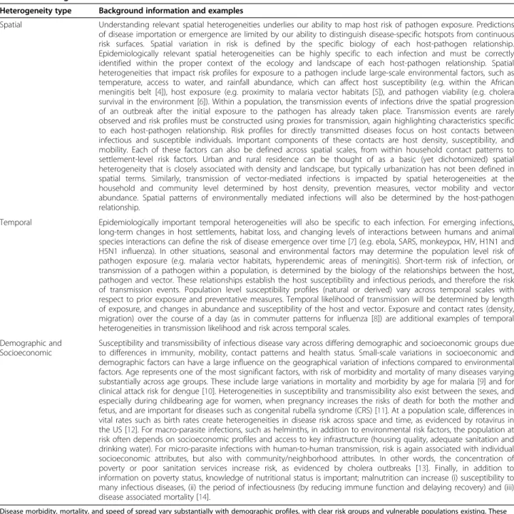
Heterogeneity type Background information and examples
Spatial Understanding relevant spatial heterogeneities underlies our ability to map host risk of pathogen exposure. Predictions of disease importation or emergence are limited by our ability to distinguish disease-specific hotspots from continuous risk surfaces. Spatial variation in risk is defined by the specific biology of each host-pathogen relationship. Epidemiologically relevant spatial heterogeneities can be highly specific to each infection and must be correctly identified within the proper context of the ecology and landscape of each host-pathogen relationship. Spatial heterogeneities that impact risk profiles for exposure to a pathogen include large-scale environmental factors, such as temperature, access to water, and rainfall abundance, which can affect host susceptibility (e.g. within the African meningitis belt [4]), host exposure (e.g. proximity to malaria vector habitats [5]), and pathogen viability (e.g. cholera survival in the environment [6]). Within a population, the transmission events of infections drive the spatial progression of an outbreak after the initial exposure to the pathogen has already taken place. Transmission events are rarely observed and risk profiles must be constructed using proxies for transmission, again highlighting characteristics specific to each host-pathogen relationship. Risk profiles for directly transmitted diseases focus on host contacts between infectious and susceptible individuals. Important components of these contacts are host density, susceptibility, and mobility. Each of these factors can also be defined across spatial scales, from within household contact patterns to settlement-level risk factors. Urban and rural residence can be thought of as a basic (yet dichotomized) spatial heterogeneity that is closely associated with density and landscape, but typically urbanization has not been defined in spatial terms. Similarly, transmission of vector-mediated infections is impacted by spatial heterogeneities at the household and community level determined by host density, prevention measures, vector mobility and vector abundance. Spatial patterns of environmentally mediated infections will also be determined by the host-pathogen relationship.
Temporal Epidemiologically important temporal heterogeneities will also be specific to each infection. For emerging infections, long-term changes in host settlements, habitat loss, and changing levels of interactions between humans and animal species interactions can define the risk of disease emergence over time [7] (e.g. ebola, SARS, monkeypox, HIV, H1N1 and H5N1 influenza). In other situations, seasonal and environmental factors may determine the population level risk of pathogen exposure (e.g. malaria vector habitats, hyperendemic areas of meningitis). Short-term risk of infection, or transmission of a pathogen within a population, is determined by the biology of the relationships between the host, pathogen and vector. These relationships establish the host susceptibility and infectious periods, and therefore the risk of transmission events. Population level susceptibility profiles (natural or derived) vary across temporal scales with respect to prior exposure and preventative measures. Temporal likelihood of transmission will be determined by length of exposure, and changes in abundance and susceptibility of the host and vector. Exposure and contact rates (density, migration) over the course of a day (as in commuter patterns for influenza [8]) are additional examples of temporal heterogeneities in transmission likelihood and risk across temporal scales.
Demographic and Socioeconomic
Susceptibility and transmissibility of infectious disease vary across differing demographic and socioeconomic groups due to differences in immunity, mobility, contact patterns and health status. Small-scale variations in socioeconomic and demographic factors can have a large influence on the geographical variation of infections compared to environmental factors. Age represents one of the most significant factors, with risk of morbidity and mortality of many diseases varying substantially across age groups. These include large variations in mortality and morbidity by age for malaria [9] and for clinical attack risk for dengue [10]. Heterogeneities in susceptibility and transmissibility also exist between the sexes, and especially during childbearing age for women, when pregnancy increases the risks of death for both the mother and fetus, and are important for diseases such as congenital rubella syndrome (CRS) [11]. At a population scale, differences in vital rates such as birth rates create heterogeneities in disease risk across space and time, as evidenced by rotavirus in the US [12]. For macro-parasite infections, such as helminths, in addition to environmental risk factors, the population at risk often depends on socioeconomic profiles and access to key infrastructure (housing quality, adequate sanitation and drinking water). For micro-parasite infections with human-to-human transmission, risk is again associated with individual socioeconomic attributes, but also with community/neighborhood attributes. In other words, the concentration of poverty or poor sanitation services increase risk, as evidenced by cholera outbreaks [13]. Finally, in addition to information on poverty status, knowledge of nutritional status is important; malnutrition can increase (i) susceptibility to many infectious diseases, (ii) the period of infectiousness (by reducing immune function and delaying recovery) and (iii) disease associated mortality [14].
Disease morbidity, mortality, and speed of spread vary substantially with demographic profiles, with clear risk groups and vulnerable populations existing. These have important implications for planning and targeting intervention strategies. The risk of pathogen infection to host populations exists at two spatial levels. First, there is a probability of initial exposure of a population to a pathogen, which defines the population risk. Second, there is a probability of transmission of a disease within a population, which defines the individual risk. Within these epidemic and endemic classifications, the implications for interventions vary across disease landscapes dependent upon the host-pathogen relationships.
nutritional status, vaccination rates, or child mortality. From a public health perspective, detailed spatial data-sets not only allow investigation of the relationship be-tween policy inputs and individual-specific outcomes, but also build detailed and realistic predictive models and derive suites of health metrics. Disease mapping and spatial modeling studies have become increasingly detailed and sophisticated, with rigorous handling of un-certainties built in, but are limited when it comes to esti-mating populations at risk. Detailed spatial datasets on population distributions now exist, but maps of other demographic and socioeconomic characteristics to iden-tify vulnerable subgroups remain lacking. To quaniden-tify these spatial variations in population attributes, recent high-impact studies have had to overlook subnational demographic variations in characteristics and rely on ap-plying simple national-scale adjustments, e.g. [5,15-17].
The availability of high-resolution population data has increased dramatically through a series of global popula-tion mapping efforts over the past 15 years. Initially restricted to a few countries, location-specific population numbers have been made available for the globe over the past decades through the combined efforts of pro-jects like the Gridded Population of the World (GPW) [18], the Global Rural Urban Mapping Project (GRUMP) [19], LandScan [20], and AfriPop [21](www.afripop.org). All databases are in the public domain and allow indivi-duals, companies, researchers, and policymakers to ac-cess population data either by administrative units or by user-specified geographic boundaries of interest. While the generation of these comprehensive population data-bases clearly constitutes a major achievement from a sci-entific perspective, two main factors limit the degree to which these databases can be used for research as well as for policy and planning: limited time frames and lim-ited information on population attributes of interest. The first limitation is mostly the result of the irregular collection of detailed population data as well as the ef-fort required in compiling global datasets at any given point in time. Given that most countries independently collect full censuses only once per decade and data shar-ing is complicated by a large set of copyright issues, most current population databases contain population data only on a five- or 10-year basis. When analyses war-rant data for noncensus years, national growth rates [22], subnational growth rates from National Statistical Offices, or interpolation between available data points may be applied to produce estimates for intermediate years, as annual population fluctuations are generally limited.
The second constraint is more critical: little is known about characteristics of the underlying populations being mapped in detail. From a planning or research perspec-tive, these factors can be of critical importance, as
outlined in Table 1. Various freely available datasets exist to facilitate mapping improvements and add significant value to epidemiological analyses, but these remain scat-tered across different sources and require processing to be integrated into mapping. Here we review these sources of more detailed, contemporary, freely available, and relevant spatial demographic data, focusing on low-income regions of the world where disease burden is highest, and put forward a strategy for building an open-access database to link the various datasets, tailored to epidemiological applications.
Usages of spatial demographic data in epidemiology
Population distribution datasets constitute an essential denominator required for many infectious disease stud-ies. It is well known that disease transmission is spatially focal and heterogeneous (Table 1), partially due to the clustered nature of population distribution. The epi-demiology of many diseases makes surveillance-based methods (reliant upon reporting from health facilities) for estimating populations at risk and disease burden problematic, particularly in low-income regions [23-25], while spatial heterogeneity in human population distri-bution can produce significant effects on transmission [3,26]. Cartographic and spatial modeling approaches have proven to be effective in tackling these factors (e.g., [27-29]). Such approaches can help characterize large-scale patterns of disease spread to evaluate intervention impact [3] and produce globally consistent measures of morbidity of known fidelity, which often represent the only plausible method in many African countries where surveillance data is incomplete, unreliable, and inconsist-ent [23,30,31]. As the precision and detail of disease risk mapping and modeling improves, spatial population datasets that capture these patterns are therefore required if populations at risk are to be more accurately quantified and disease spread among populations is real-istically modeled for prediction and prevention purposes. Uses of gridded population count data in epidemio-logical studies are documented in Tatem et al. [1] and Linard and Tatem [32], and here we focus on studies that have attempted to incorporate spatial data on popu-lation subgroups.
Applications of gridded population datasets in epi-demiology have involved estimating numbers of clinical cases, modeling the spatial progression of an epidemic, risk mapping and assessing the effects of urbanization, and the study of diseases ranging from dengue and yel-low fever to HIV and leprosy. The majority of spatial modeling approaches of infectious diseases have been based on the environmental correlates of infection, due in part to the availability of high spatial resolution envir-onmental data and relative paucity of spatial socioeco-nomic and demographic data. The most widespread uses
of gridded population datasets in an epidemiological context have been in the study of malaria. Global spatial demographic datasets have been used to estimate popu-lations at risk of malaria, which forms a fundamental metric for decision-makers at national and international levels [30,33]. While approaches for mapping malaria have become increasingly sophisticated (e.g., [2]), those for mapping population distributions have not kept pace, especially in low-income regions [1], where detailed spatial information on population composition is rarely available or utilized.
Previous studies that have aimed to enumerate vulner-able population subgroups at risk for different diseases have solely focused on utilizing simplistic national-level adjustments. The malaria burden in children under 5 years old was recently estimated based on a Zambia-wide survey and LandScan population data adjusted by a national-level estimate of the proportion of under-5 chil-dren [34]. Similarly, the numbers at risk of malaria glo-bally in different age groups were estimated by applying national-level adjustments to GRUMP data [5,29,35,36]. Models of disease prevalence were overlaid onto popula-tion density maps adjusted by napopula-tional-level proporpopula-tions again to quantify school-age children and young adults at risk of schistosomiasis [17,37-40] and hookworm [38,41-43] and the number of pregnant women infected with hookworm in sub-Saharan Africa [44]. Specific esti-mates of populations at risk of malaria for pregnant women and children have also been derived from these maps, by combining GRUMP data with national-scale age, sex, and fertility data from the United Nations Population Division [15,45,46]. Finally, the numbers of children under 5 with anemia in West Africa were esti-mated using similar techniques [16]. In all of these
examples outlined here, the problems of overlooking sub-national variations in population through the sub- national-level adjustments applied are illustrated in an example in the next section.
Spatio-temporal transmission models aim to simulate contacts between infectious and susceptible individuals and estimate the spatial spread of the disease. This helps to identify areas and times at risk of disease and assists in planning targeted interventions [47,48]. Sophisticated spatially explicit models have been developed to study the spatial progression of infectious diseases. Many of such spatially explicit models have made use of gridded population datasets as input data [3,49]. Gridded popu-lation data have also been used to develop agent-based simulation models at the regional level [28,50,51] and at the global level [52,53]. Whatever the spatial approach for modeling, population data are essential as these models, which generally require the generation of a vir-tual society with an appropriate distribution and com-position of people [3]. Gridded data are preferred by these models in that the gridding process removes the ir-regularity associated with the native administrative units in which these data were initially reported and thereby makes the data more flexible for use with a variety of other spatial units or features. In addition, global (or continent-level) gridded population data provide valu-able input datasets mainly because of their wide cover-age, consistent spatial resolution, and availability in the public domain. Notably missing as discussed above is in-formation on population attributes. This represents a limitation for models that can be substantially improved through the incorporation of realistic population attri-butes to build ‘synthetic’ populations. Previous studies have had to rely on national-level statistics or the
Figure 1 For Tanzania in 2007: (a) P. falciparum malaria transmission classes (adapted from Hay [5], measured by P. falciparum Parasite Rate (PfPR), (b) percentage of residents under 5 years of age by ward, (c) percentage differences in estimates of number of children under 5 at risk of the highest transmission class by national- vs. ward-level adjustments.
application of census-derived attributes from one coun-try applied to multiple others (e.g., [28]).
Improving estimates of children under 5 years at risk of Plasmodium falciparum malaria
The lack of availability of subnational spatial datasets on specific population groups that are particularly vulner-able to P. falciparum malaria has meant that simple na-tional-level adjustments have been applied in influential studies to estimate the spatial distributions of, for ex-ample, children under 5 [15] or pregnant women [45,46] at risk. To illustrate the importance of mapping vulner-able populations to a level of spatial detail approaching that now used in disease mapping, here we compare estimates of under-5 children at risk of P. falciparum malaria in Tanzania in 2007 using transmission risk classes (Figure 1(a))[5] overlaid onto a population distri-bution map (www.afripop.org) adjusted to represent children under 5 by (i) applying a single nationwide per-centage adjustment as defined by the UN’s World Popu-lation Prospects [22] (as undertaken in [15] – for Tanzania, percentage under 5 is estimated to be 17.9%) and (ii) applying per-district proportions of under-5 chil-dren derived from ward-level census data (Figure 1(b)).
Table 2 shows the difference in estimates of under-5 children residing in each transmission class, with large percentage differences found in each transmission class. We do not examine the spatial patterns of differences here, as this is beyond the scope of this analysis, but they remain an interesting area for exploration [1]. Overall, the adjustments from finer-scale age distributions indi-cate that national-level estimates substantially overesti-mate numbers at risk. Whereas Table 2 summarizes the overestimates by transmission classes, Figure 1(c) shows the spatial pattern of the misestimation in the highest transmission class. It shows the percentage differences obtained in estimates of under-5 children at risk of PfPR > 40% transmission level (mapped in Figure 1(a)) result-ing from use of the ward-level map of children under 5 years rather than from applying a single nationwide adjustment. Most of these wards show differences above 25%, and several have discrepancies of greater than 100%. These malaria transmission maps and the
populations at risk estimates derived from them are in-creasingly being used to guide planning, policy, and con-trol. Such substantial differences in estimates of populations at risk, achievable through the use of an improved spatial demographic composition data, illus-trate the urgent need to develop spatial databases of vul-nerable populations.
Spatial demographic data to meet needs
From an epidemiological and health metrics perspective, fundamental characteristics are age and sex. The most commonly needed age-sex specific groups in developing countries are: infants, children under 5, women of child-bearing ages, and the elderly (Table 1). More specific needs might require the population of pregnant women, young adults, or urban children. Even though these numbers can generally be approximated by multiplying total population numbers by estimated national popula-tion fracpopula-tions, the large epidemiologically important het-erogeneity in population composition generated by migration and differential mortality and birth rates within countries and regions, and particularly between urban and rural residents, is likely to induce substantial degrees of imprecision in resultant output metrics (see previous section). The problem becomes even more se-vere when researchers or policy makers are primarily interested in nondemographic aspects of the population. In many cases, the main variable of interest may be a fraction of the population with certain health or behav-ioral characteristics: the number of children not vacci-nated, the number of women without access to contraceptives, the number of children not going to school or not receiving formal health care. Many of these characteristics are not census-based, but rather can be ascertained through survey data, an aspect that we shall discuss in further detail below. Clearly it is not feasible for global population databases to generate on-demand maps for each of these factors on a regular basis, nevertheless the potential to leverage current freely available population databases appears large. Table 3 documents the principal datasets that are readily available without cost across multiple countries to achieve this.
Census data form the basis of existing spatial demo-graphic databases [19,20], and such population and hous-ing censuses are undertaken for almost all countries in the world, including developing countries, generally every 10 years (the date of past and upcoming planned censuses are available here: http://unstats.un.org/unsd/ demographic/sources/census/censusdates.htm), but these provide only population counts. A range of other popula-tion-attribute information is generally collected during population censuses such as age, gender, urban/rural residence, and migration information, and, for the
Table 2 Estimates of numbers of children under 5 at risk ofP. falciparum malaria in Tanzania using the two differing demographic methods described in the text
Transmission Class U5PAR1: UN Nationwide adjusted U5PAR2: Census unit adjustments Percentage change from U5PAR1 to U5PAR2 PfPR< 5% 770547 650174 −15.62175961 PfPR = 5–40% 4315638 3383040 −21.6097365 PfPR> 40% 773992 630518 −18.5368841
Table 3 Sources of freely available spatial demographic data
Data (standard survey name)/ source
Time intervals Typical spatial coverage Typical strata Relevant variables Census
National Statistical Offices
Typically 10 years Census enumerator area or courser level
Urban/rural, race or ethnic groups (often)
Sex, age, education, migration status, household and dwelling characteristics Census Microdata
https://international. ipums.org/ international/
Typically 10 years Admin 1-3 Urban/rural Household and dwelling characteristics, sex, age, education, migration status, children ever born, children surviving DHS (Demographic
and Health Survey) Household, women 15–49, men 15–59, children born in the last five years
http://www. measuredhs.com/
Varies by country, typically every 5 years
National, Admin 1/region, GPS coordinates of cluster locations for most recent surveys (last 15 years)
Urban/rural Household and dwelling characteristics, sex, age, education, maternal and child health, fertility and full birth history, family planning, domestic violence, biomarkers, nutrition MICS (Multi-indicator cluster survey) http://www.unicef. org/statistics/ index_24302.html UNICEF (Round 2, 1999–2001; round 3 2005–2007; round 4 is in the field 2009–present)
National, Admin 1 Urban/rural Household and dwelling characteristics, sex, age, education, status, maternal and child health, child labor, domestic violence, summary birth history, anthropometry LSMS (Living Standard
Measure Survey) (Integrated Household Budget Survey and many others that are locally adapted)
http://iresearch. worldbank.org/lsms/ lsmssurveyFinder.htm
Irregular National, Admin 1, some GPS coordinates
Urban/rural Household and
dwelling characteristics, sex, age, education, migration status,consumption, expenditures, income, nutrition,anthropometry, summary birth history MIS (Malaria Indicator Survey) http://www. measuredhs.com/ http://www. malariasurveys.org/ Varies by country, typically every 3 years
National, Admin 1/region, GPS coordinates of cluster locations for some surveys (last five years)
Urban/rural Household and dwelling characteristics, sex, age,
Table 3 Sources of freely available spatial demographic data (Continued)
AIS (AIDS Indicator Survey)
http://www. measuredhs.com/
Varies by country, typically every 3 years
National, Admin 1/region, GPS coordinates of cluster locations for some surveys (last eight years)
Urban/rural Household and dwelling characteristics, sex, age,
education, biomarkers DHS (Demographic
and Health Survey) Household, women 15–49, men 15–59, children born in the last five years
http://www. measuredhs.com/
Varies by country, typically every 5 years
National, Admin 1/region, GPS coordinates of cluster locations for most recent surveys (last 15 years)
Urban/rural Household and
dwelling characteristics, sex, age, education, maternal and child health, fertility and full birth history,
family planning, domestic violence, biomarkers, nutrition MICS (Multi-indicator cluster survey) http://www.unicef. org/statistics/ index_24302.html UNICEF (Round 2, 1999–2001; round 3 2005–2007; round 4 is in the field 2009-present)
National, Admin 1 Urban/rural Household and
dwelling characteristics, sex, age, education, status, maternal and child health, child labor, domestic violence, summary birth history, anthropometry LSMS (Living Standard
Measure Survey) (Integrated Household Budget Survey and many others that are locally adapted)
http://iresearch. worldbank.org/lsms/ lsmssurveyFinder.htm
Irregular National, Admin 1, some GPS coordinates
Urban/rural Household and
dwelling characteristics, sex, age, education, migration status, consumption, expenditures, income, nutrition, anthropometry, summary birth history
MIS (Malaria Indicator Survey) http://www. measuredhs.com/ http://www. malariasurveys.org/ Varies by country, typically every 3 years National, Admin 1/region, GPS coordinates of cluster locations for some surveys (last five years)
Urban/rural Household and
dwelling characteristics, sex, age, education, biomarkers AIS (AIDS Indicator
Survey) http://www. measuredhs.com/ Varies by country, typically every 3 years National, Admin 1/region, GPS coordinates of cluster locations for some surveys (last eight years)
Urban/rural Household and
dwelling characteristics, sex, age, education, biomarkers
majority of countries, made available in some form on national statistical office websites. This information sup-plies a series of single population characteristics at what-ever level of geographic detail is made available by the National Statistical Office. Often, this information is available through data tables aggregated at coarse admin-istrative levels, however, and full-detail datasets can be
difficult to obtain. An addition to the aggregated full cen-sus data are large samples of household-level records derived from censuses (census microdata) that provide age and sex structure, as well as many other compos-itional measures, reported generally by administrative level 1 (e.g., province) or 2 (e.g., district). These data keep information about households intact so that
Figure 2 Maps showing the availability of useful demographic datasets for deriving subnational estimates of population attributes. (a) Numbers of census microdata records maintained at the International Public Use Microdata Series repository (https://international.ipums.org/ international/), (b) combined numbers of Demographic and Health Surveys (DHS), Malaria Indicator Surveys (MIS), and AIDS Indicator Surveys (AIS) conducted for each country, (c) combined numbers of DHS, MIS, and AIS with GPS cluster coordinates available.
combinations of variables can be made. The largest re-pository of such data is the International Public Use Micro-data Series (https://international.ipums.org/international/) and the data held there are mapped in Figure 2(a).
While census aggregates and census microdata sam-ples are typically large enough to cover small or moder-ately sized geographic areas, they are only carried out approximately every 10 years and are limited in content. Survey data offer much richer content on shorter time intervals but are limited in spatial coverage (e.g., Figure 2 (b)). In most high- and low-income countries, geo-referenced household-based surveys are collected on a regu-lar basis. These surveys contain detailed local population
characteristics for a finite number of locations, which could be used to generate characteristic-prevalence sur-faces for a given country and year. Overlaying these characteristic surfaces with population estimates would likely become an invaluable tool both for researchers and policymakers.
Data on a rich variety of population attributes can be obtained from a range of international household survey programs, each of which is listed in Table 3. These pro-vide subnational urban (or rural) age and sex structures, educational compositions, employment information, and countless other socioeconomic and health indicators at the level of subnational regions. Large household survey
Figure 3 Design of a relational spatial demographic database. Table 4 provides details on each layer.
Table 4 Components of relational spatial demographic database based on freely available datasets
Feature Example dataset Example dataset source National boundaries SALB www.unsalb.org Administrative boundaries GADM www.gadm.org DHS boundaries MEASURE DHS www.measuredhs.com Coastlines GBWD http://dds.cr.usgs.gov/srtm/
Water bodies SWDB http://dds.cr.usgs.gov/srtm/version2_1/SWBD/ Land cover GlobCover www.ionia1.esrin.esa.int
Protected areas WDBPA www.wdpa.org
Urban extents MODIS http://www.sage.wisc.edu/people/schneider/research/data.html
Settlement locations NGA Geonames www.earth-info.nga.mil/gns/html Elevation and slope SRTM www.srtm.csi.cgiar.org
programs such as the Multiple Indicator Cluster Surveys (MICS) and Demographic and Health Surveys (DHS) listed in Table 3 are reasonably well standardized and cover many low-income countries (Figure 2(b), with multiple rounds in each country. Additionally, in most recent DHS data sets, the survey clusters have been geo-coded (Figure 2(c)). In order to protect the confidential-ity of survey respondents, cluster locations are randomly displaced by up to 2 km in urban areas and 5 km in rural areas. Moreover, in rural areas, the DHS cluster locations provided can represent large and potentially heterogeneous areas. The existing approaches using DHS data have not taken advantage of spatial modeling to expand the use of DHS data below the survey region level (usually administrative level 1). The geocoded clus-ter data from the DHS allow for data regrouping to dif-ferent levels of representativeness while still respecting the sample frame. While MICS now regularly collect geocoded data, these datasets are not available to enable mapping of the data at finer level than the survey region level.
Each of the datasets described here and listed in Table 3 report demographic information aggregated by named administrative units. Rarely, however, are spatial data on the boundaries of these units provided with the data. For spatial analysis, therefore, GIS boundary data-sets must be found that match the reported administra-tive units. This is often a nontrivial task given regular boundary changes over time, alternative names, and mis-matches with national boundaries. The initiation of open access repositories of standardized administrative boundary datasets (e.g., GADM: http://www.gadm.org/), and documented histories of changes (e.g., http://www. statoids.com/) simplifies such operations. Moreover, DHS also shares the geography for their surveys on request.
Designing a spatial demographic database
The datasets described in the previous section are pres-ently scattered across disparate sources (Table 3). To better fulfill the needs of disease modeling and carto-graphic-style derivations of health metrics, we propose the construction of a spatial database. The construction of this database would involve not only the housing of the disparate demographic datasets in a central open ac-cess location, but also their linkage to GIS datasets to enable the construction of spatial datasets representing a variety of epidemiologically relevant variables. The re-cent development of spatially enabling tools for database servers, such as PostGIS (http://postgis.refractions.net), which provides support for geographic objects in object-relational databases, provides the ideal framework for construction of the database. The database would be hosted on a central server and accessed through an
interactive web portal. Table 4 outlines the spatial data-sets that would be included in a database to spatially reference the datasets in Table 3 and provide additional information to increase mapping capabilities. The frame-work spatial data are open-access GIS datasets that can be reused by multiple organizations for different pur-poses. Figure 3 outlines how these datasets link together in the relational spatial database. The key objectives of this database would be to:
1. Provide disaggregated spatially-referenced data on population sizes and characteristics such as age, sex, urban/rural location, and education
2. Facilitate data sharing between differing platforms and demographic mapping projects
3. Provide a high degree of transparency,
documentation, and flexibility with respect to data sources and the treatment of uncertainty
The database is designed to encourage data sharing, built in a manner that can be replicated across different nodes, with standardized, agreed-upon representations. For example, whilst the GRUMP and AfriPop project outputs take different forms and use differing modeling techniques, each is built upon standard representations (national boundaries, coastlines, administrative units) and aim to use the most detailed and contemporary population data available. A standardized database framework would encourage sharing of new and improved datasets between projects, benefitting a range of user groups. By building in differing levels of access control, new datasets can be reviewed and processed be-fore release to a wider user community, and also data-sets that remain copyrighted can be controlled in their accessibility.
Documentation of all aspects of the data and database structure are key to ensuring ease of use, integration with epidemiological applications, and accessibility to a wide user community. This will focus around database version control, the development of a data dictionary, with full documentation of the datasets archived within it, and metadata accompanying the GIS-related data-sets. The distinction between spatial metadata and a data dictionary must be made: they are much different and both are necessary. A data dictionary is needed to understand the shortened name and values of particular variables, for example, whereas the metadata speak to the spatial lineage and quality of the data. Some institu-tional or database history is sometimes warranted, for example, when data collection for a given variable has changed. Ensuring that this documentation is oriented toward the user through full explanation of assumptions made and quality issues with the data provided will be important. Moreover, the construction of a library of
tools and techniques for analyzing and using the data within the database using a forum and other mechan-isms, such as a code repository, will facilitate ease of use. Finally, the provision of quantitative measures of data quality and uncertainty will be of great importance. This could range from basic information of the timeli-ness, resolution, spatial uncertainty, and standard errors of datasets that enable informed interpretation of result-ing mapped products to the more rigorous handlresult-ing and measurement of uncertainties (see next section).
New methods, data, and future challenges
We have so far outlined datasets and a basic framework for compiling them to meet immediate disease modeling and health metric demographic needs. Several opportun-ities and possibilopportun-ities exist however with which to supplement and improve the scope and accuracy of resources available. Here we outline these briefly, along with future challenges likely to be faced in implementation.
Urban populations
The health divide between urban and rural populations has been well documented [54], as have the increasing levels of urbanization around the world [55]. While much has been done in the past 10 years to refine popu-lation data that delineates urban areas [19,56,57], much less is known about populations within cities even within relatively coarse divisions (city center, suburban, peri-urban) or by slum dwellers and others (much also remains to be learned about population distribution within rural areas). Africa, in particular, will undergo rapid urbanization in the coming decades [55], yet the data record to understand the demographic variation and health conditions in these cities, let alone changes in dis-ease transmission that may result from urban change, is largely absent. If it is important to understand what is happening within urban areas, even the currently available cluster-level data of the DHS program (Figure 2(c)) is in-adequate. While the DHS program and some other sur-veys have focused on collecting larger urban samples, there remains a need for large samples of urban popula-tions to permit city-specific analyses. Additionally, the def-inition of urban is not standard across the DHS countries. There is reason to believe that even greater heterogeneity of health and socioeconomic characteristics exist within urban areas.
As with the demographic datasets discussed already, there are a variety of disparate spatial datasets on urban populations that could be brought together to get a bet-ter perspective. City population counts for cities with populations of 100,000 and above are produced by the UN Population Division World Urbanization Prospects [55]. Alternative sources of city and settlement
population sizes include the City Population website (www.citypopulation.de), while different projects are fo-cused on mapping city extents, which these counts could be matched to (e.g., [19,58], www.afripop.org). There still exist significant gaps, however, such as time-series of urban spatial extents, which would facilitate the develop-ment of ways to forecast changes in urban extents. Also, information on properly defined neighborhoods within cities is important, such as within-household and within-neighborhood population density, but so are other contexts (e.g., schools).
Subnational spatial and temporal projections
Most low-income countries do not produce population projections, or forecasts, at a subnational level. Even the United Nations Population Division’s urban population projections [55] do not produce city-level population projections. Yet the demographic inputs for generating subnational estimates and projections are increasingly becoming available. Subnational projections are now being undertaken at least for very large countries (for example, India and China) and for small and large cities in the developing world [59]. For the latter, the forecast-ing method departs from the traditional cohort-compo-nent method and instead uses longitudinal data on cities and subnational estimates of demographic rates (urban fertility, mortality, and migration) derived from survey and census microdata in an econometric model of city growth [60]. These new approaches depend on harnes-sing old data in a spatial framework. The spatial frame-work allows disparate units to be linked in new ways, yielding new estimates and projections. Because these methods are largely probabilistic and derived from mod-eling exercises, the uncertainty associated with these estimates should also be characterized.
Quantifying uncertainty
The variety of ages, spatial resolutions, and sample sizes of input demographic data translates to great variations in accuracies and uncertainties of any output gridded demographic data products, and this is rarely acknowl-edged [1]. The most basic level of quantification and communication of this uncertainty to users involves the provision of information on input datasets and methods used in construction, such as is undertaken for GPW, GRUMP [19], and AfriPop [21] (www.afripop.org). Ideally, a more rigorous quantification of the uncertainty inherent in output gridded demographic datasets should be undertaken. The rigorous handling and propagation of uncertainty through a mapping process is now regu-larly undertaken in disease risk mapping within a Bayes-ian framework (e.g., [2,16,17]), resulting in full posterior prediction distributions for each grid cell, providing flexibility in the derivation of differing uncertainty
metrics and enabling the production of accompanying uncertainty maps. Undertaking an equivalent approach for deriving accompanying uncertainty maps for demo-graphic datasets would require consideration of the in-put datasets and outin-put requirements. For instance, this could take the form of estimating the uncertainty in gridded population distribution mapping from census data summarized by administrative unit. Here, two of the major sources of uncertainty are the age of the cen-sus data in relation to the output prediction year and the size of the administrative units relative to the population sizes within them and output grid cell size. While uncer-tainty in temporal projection of census data is relatively well studied, the spatial aspect remains unexplored. For example, gridding a 50,000 km2administrative unit con-taining 1 million children under age 5 to 30 arc second resolution results in greater uncertainty about the popu-lation size and composition residing in each grid square than does the same resolution gridding of a 1,000 km2 administrative unit containing 10,000 children under age 5. Based on simulating all possible permutations of grid square composition, bound by the limits imposed by the original administrative unit size and vulnerable popula-tion totals, per-grid square measures of spatial uncer-tainty in composition that relate directly to the gridding methodology could be derived. Secondly, the availability of the DHS cluster locations opens up the possibility of estimating surfaces of variables with associated uncer-tainty, and this is discussed below.
Gridding household survey data
The availability of the GPS coordinates of DHS clusters (Figure 2(c)) has prompted several studies to utilize geostatistical approaches to derive continuous estimated surfaces of variables of interest. However, survey data are generally collected to be nationally representative and, as such, their sampling frames may not lend them-selves to finely resolved geographic grids. The DHS pro-gram has been a leader in collecting and providing geocoded information of the survey clusters in addition to their standard data files in which data can be tabu-lated by first-order subnational regions as well as urban/ rural classification. Early examples have demonstrated the value of such approaches for deriving continuous maps of variables of interest from geolocated DHS clus-ter data. For example, Gemperli et al. [61] investigated spatial patterns of malaria endemicity as well as socio-economic risk factors on infant mortality in Mali using a Bayesian hierarchical geostatistical model. Meanwhile, Soares and Clements [16] used a similar approach for anemia mapping. However, these approaches did not take account of the DHS sampling design or the random spatial displacement that cluster data undergo, and over-coming these issues should be a priority for future
applications [62]. Apart from utilizing the cluster loca-tion, the subnational regions supply information that can be used with more finely resolved grids. One approach that uses spatial coverage of census aggregates combined with the attribute breadth in survey data is that of the Poverty Mapping efforts [63]. But this is not necessarily the only approach to consider.
Migration and mobility mapping
Very little is known about migration and mobility within countries, which may occur seasonally and periodically as well as permanently, except through case studies and qualitative place-specific analyses. Disease modeling and health metric derivation, as well as demographic ana-lyses, increasingly require information on migration and mobility [64-66]. These data are the weak link of the demographic record – even the stock estimates of sub-national migration have been largely ignored. Disease modelers often want to know about daily movements ra-ther than decadal ones, but the decadal moves may be important to evaluate for changes to place-specific vul-nerability of residents. Decadal moves should be exam-ined more closely with existing survey and census microdata; characterizing more frequent moves will re-quire data collection methods that depart from the standard demographic tool kit. Use of new data, such as spatial locations derived from GPS tracking devices [67] and cell phone usage [68] may show promise. However, to be useful, methods for using these data in combin-ation with more standard demographic data will be necessary.
Conclusions
Growing trends in research and funding for disease mapping and spatial modeling to derive health metrics and guide strategies are increasing needs for spatial demographic data of similar scope and quality for use in estimating sizes and characteristics of populations at risk. However, existing spatial demographic databases are often based on coarse resolution and outdated input and lack any consideration of population attribute map-ping. These drawbacks are likely contributing to sub-stantial uncertainties in disease modeling and health metric outputs [1]. Here we have shown that datasets to rectify this exist but remain scattered across multiple re-positories and websites, requiring collation into a central open-access database to become more widely used and build on the strengths of each data type, overcoming temporal, spatial, and attribute limitations. We have put forward a basic database design here to achieve this and lay the foundations for undertaking detailed mapping of population attributes for providing spatial demographic data in disease studies.
Competing interests
The authors declare that they have no competing interests.
Author's contributions
AJT conceived and designed the manuscript. All authors contributed to writing the manuscript and have read and approved the final manuscript.
Acknowledgments
AJT is supported by a grant from the Bill & Melinda Gates Foundation (#49446), which also supports DP. AJT acknowledges funding support from the RAPIDD program of the Science & Technology Directorate, Department of Homeland Security, and the Fogarty International Center, National Institutes of Health. CL is supported by a grant from the Fondation Philippe Wiener - Maurice Anspach. This paper is the result of a working group meeting held in May 2011 in New York, funded by the RAPIDD program of the Science & Technology Directorate, Department of Homeland Security, and the Fogarty International Center, National Institutes of Health. AD received financial support from the National Institute for Child Health and Human Development, Grant No. R24HD047879. AMN is supported by a Wellcome Trust Intermediate Research Fellowship (##095127). SA is supported in part by NASA under contract NNG08HZ11C for the continued operation of the Socioeconomic Data and Applications Center (SEDAC). CRB is supported by the US Agency for International Development-funded MEASURE Demographic and Health Survey.
Author details
1Department of Geography, University of Florida, Gainesville, USA.2Emerging
Pathogens Institute, University of Florida, Gainesville, USA.3Fogarty International Center, National Institutes of Health, Bethesda, USA.4Center for
International Earth Science Information Network (CIESIN), Columbia University, New York, USA.5Ecology and Evolutionary Biology, Princeton
University, Princeton, USA.6Demographic and Health Surveys, International Health and Development Division, ICF International, Washington DC, USA.
7
Department of Global Health and Population, Harvard School of Public Health, Boston, USA.8Office of Population Research and Woodrow Wilson
School of Public and International Affairs, Princeton University, Princeton, USA.9Biological Control and Spatial Ecology, Université Libre de Bruxelles,
Brussels, Belgium.10Fonds National de la Recherche Scientifique (F.R.S.-FNRS), Brussels, Belgium.11Research and Information Services of Namibia,
Windhoek, Namibia.12The Population Council, New York, USA.13The International Rice Research Institute, Los Banos, Philippines.14Malaria Public
Health and Epidemiology Group, Centre for Geographic Medicine, KEMRI -University of Oxford - Wellcome Trust Research Programme, Nairobi, Kenya.
15
School of Public Affairs, Baruch College, City University New York, New York, USA.16Department of Economics, Stony Brook University, New York,
USA.
Received: 28 October 2011 Accepted: 27 April 2012 Published: 16 May 2012
References
1. Tatem A, Campiz N, Gething P, Snow R, Linard C: The effects of spatial population dataset choice on estimates of population at risk of disease. Popul Health Metrics 2011, 9:4.
2. Patil AP, Gething PW, Piel FB, Hay SI: Bayesian geostatistics in health cartography: the perspective of malaria. Trends Parasitol 2011, 27:246–253. 3. Riley S: Large-scale spatial-transmission models of infectious disease.
Science 2007, 316:1298–1301.
4. Molesworth AM, Thomson MC, Connor SJ, Cresswell MP, Morse AP, Shears P, Hart CA, Cuevas LE: Where is the meningitis belt? Defining an area at risk of epidemic meningitis in Africa. Trans R Soc Trop Med Hyg 2002, 96:242–249.
5. Hay SI, Guerra CA, Gething PW, Patil AP, Tatem AJ, Noor AM, Kabaria CW, Manh BH, Elyazar IRF, Brooker SJ, et al: World malaria map: Plasmodium falciparum endemicity in 2007. PLoS Med 2009, 6:e1000048.
6. Vezzulli L, Pruzzo C, Huq A, Colwell RR: Environmental reservoirs of Vibrio cholerae and their role in cholera. Environ Microbiol Rep 2010, 2:27–33. 7. Jones KE, Patel NG, Levy MA, Storeyguard A, Balk D, Gittleman JL, Daszak P:
Global trends in emerging infectious diseases. Nature 2008, 451:990–994.
8. Viboud C, Bjornstad ON, Smith DL, Simonsen L, Miller MA, Grenfell BT: Synchrony, waves, and spatial hierarchies in the spread of influenza. Science 2006, 312:447–451.
9. Smith DL, Guerra CA, Snow RW, Hay SI: Standardizing estimates of the Plasmodium falciparum parasite rate. Malar J 2007, 6:131.
10. Egger JR, Coleman PG: Age and clinical dengue illness. Emerg Infect Dis 2007, 13:924–925.
11. Miller E, Cradock-Watson JE, Pollock TM: Consequences of confirmed maternal rubella at successive stages of pregnancy. Lancet 1982, 2:781–784. 12. Pitzer VE, Viboud C, Simonsen L, Steiner C, Panozzo CA, Alonso WJ, Miller
MA, Glass RI, Glasser JW, Parashar UD, Grenfell BT: Demographic variability, vaccination, and the spatiotemporal dynamics of rotavirus epidemics. Science 2009, 325:290–294.
13. Talavera A, Perez EM: Is cholera disease associated with poverty? J Infect Dev Ctries 2009, 3:408–411.
14. Allison SP: Malnutrition, disease and outcome. Nutrition 2000, 16:590–593. 15. Gething PW, Kirui VC, Alegana VA, Okiro EA, Noor AM, Snow RW: Estimating
the number of paediatric fevers associated with malaria infection presenting to Africa's public health sector in 2007. PLoS Med 2010, 7: e1000301.
16. Soares Magalhaes RJ, Clements ACA: Mapping the risk of anaemia in preschool-age children: the contribution of malnutrition, malaria and helminth infections in West Africa. PLoS Med 2011, 8:e1000438. 17. Schur N, Hurlimann E, Garba A, Traore MS, Ndir O, Ratard RC, Tchuente LT,
Kristensen TK, Utzinger J, Vounatsou P: Geostatistical model-based estimates of schistosomiasis prevalence among individuals aged <20 years in West Africa. PLoS Negl Trop Dis 2011, 5:e1194. 18. Deichmann U, Balk D, Yetman G: Transforming population data for
interdisciplinary usages: from census to grid. 2001, Documentation for GPW Version 2 available only at http://sedac.ciesin.columbia.edu/plue/gpw/ GPW documentation.pdf.
19. Balk DL, Deichmann U, Yetman G, Pozzi F, Hay SI, Nelson A: Determining global population distribution: methods, applications and data. Adv Parasitol 2006, 62:119–156.
20. Dobson JE, Bright EA, Coleman PR, Durfee RC, Worley BA: LandScan: a global population database for estimating populations at risk. Photogramm Eng Remote Sens 2000, 66:849–857.
21. Linard C, Gilbert M, Snow RW, Noor AM, Tatem AJ: Population distribution, settlement patterns and accessibility across Africa in 2010. PLoS One 2012, 7:e31743.
22. United Nations Population Division: World population prospects, 2010 revision. New York: United Nations; 2010.
23. Gething PW, Noor AM, Gikandi PW, Ogara EAA, Hay SI, Nixon MS, Snow RW, Atkinson PM: Improving imperfect data from health management information systems in Africa using space-time geostatistics. PLoS Med 2006, 3:e271.
24. Health Metrics Network: Statistics save lives: Strengthening country health information systems. Geneva: WHO Health Metrics Network; 2005. 25. Murray CJL, Lopez AD, Wibulpolprasert S: Monitoring global health: Time
for new solutions. Br Med J 2004, 329:1096–1100.
26. Kubiak RJ, Arinaminpathy N, McLean AR: Insights into the evolution and emergence of a novel infectious disease. PLoS Comput Biol 2010, 6:e1000947.
27. Brooker S, Hay SI, Bundy DA: Tools from ecology: useful for evaluating infection risk models? Trends Parasitol 2002, 18:70–74.
28. Ferguson NM, Cummings DAT, Cauchemez S, Fraser C, Riley S, Meeyai A, Iamsirithaworn S, Burke DS: Strategies for containing an emerging influenza pandemic in Southeast Asia. Nature 2005, 437:209–214. 29. Hay SI, Okiro EA, Gething PW, Patil AP, Tatem AJ, Guerra CA, Snow RW:
Estimating the global clinical burden of Plasmodium falciparum malaria in 2007. PLoS Med 2010, 7:e100029.
30. World Health Organization: The World Malaria Report. Geneva: World Health Organization; 2008.
31. Cibulskis RE, Bell D, Christophel EM, Hii J, Delacollette C, Bakyaita N, Aregawi MW: Estimating trends in the burden of malaria at country level. AmJTrop Med Hyg 2007, 77:133–137.
32. Linard C, Tatem AJ: Large-scale spatial population databases in infectious disease research. Int J Heal Geogr 2012, 11:7.
33. Johansson EW, Newby H, Renshaw M, Wardlaw T: Malaria and children. progress in intervention coverage. New York: United Nations Children's Fund (UNICEF)/The Roll Back Malaria Partnership (RBM); 2007.
34. Riedel N, Vounatsou P, Miller JM, Gosoniu L, Chizema-Kawesha E, Mukonka V, Steketee RW: Geographical patterns and predictors of malaria risk in Zambia: Bayesian geostatistical modelling of the 2006 Zambia national malaria indicator survey (ZMIS). Malar J 2010, 9:37.
35. Guerra CA, Howes RE, Patil AP, Gething PW, Van Boeckel TP, Temperley WH, Kabaria CW, Tatem AJ, Manh BH, Elyazar IRF, et al: The international limits and population at risk of Plasmodium vivax transmission in 2009. PLoS Negl Trop Dis 2010, 4:e774.
36. Guerra CA, Gikandi PW, Tatem AJ, Noor AM, Smith DL, Hay SI, Snow RW: The limits and intensity of Plasmodium falciparum transmission: implications for malaria control and elimination worldwide. PLoS Med 2008, 5:e38.
37. Brooker S, Miguel E, Waswa P, Namunyu R, Moulin S, Guyatt H, Bundy D: The potential of rapid screening methods for Schistosoma mansoni in western Kenya. Ann Trop Med Parasitol 2001, 95:343–351.
38. Brooker S, Beasley M, Ndinaromtan M, Madjiouroum EM, Baboguel M, Djenguinabe E, Hay SI, Bundy DA: Use of remote sensing and a geographical information system in a national helminth control programme in Chad. Bull World Health Organ 2002, 80:783–789. 39. Kabatereine N, Brooker S, Tukahebwa E, Kazibwe F, Onapa A: Epidemiology
and geography of Schistosoma mansoni in Uganda: implications for planning control. Trop Med Int Health 2004, 9:372.
40. Clements ACA, Firth S, Dembele R, Garba A, Toure S, Sacko M, Landoure A, Bosque-Oliva E, Barnett AG, Brooker S, Fenwick A: Use of Bayesian geostatistical prediction to estimate local variations in Schistosoma haematobium infection in western Africa. Bull World Health Organ 2009, 87:921–929.
41. Brooker SJ, Clements ACA, Hotez PJ, Hay SI, Tatem AJ, Bundy DAP, Snow RW: The co-distribution of Plasmodium falciparum and hookworm among African schoolchildren. Malar J 2006, 5:99.
42. Pullan RL, Gething PW, Smith JL, Mwandawiro CS, Sturrock HJ, Gitonga CW, Hay SI, Brooker S: Spatial modelling of soil-transmitted helminth infections in Kenya: a disease control planning tool. PLoS Negl Trop Dis 2011, 5:e958.
43. Brooker S, Clements AC, Bundy DA: Global epidemiology, ecology and control of soil-transmitted helminth infections. Adv Parasitol 2006, 62:221–261.
44. Brooker S, Hotez PJ, Bundy DA: Hookworm-related anaemia among pregnant women: a systematic review. PLoS Negl Trop Dis 2008, 2:e291. 45. Dellicour S, Tatem AJ, Guerra CA, Snow RW, ter Kuile FO: Quantifying the
number of pregnancies at risk of malaria in 2007: a demographic study. PLoS Med 2010, 7:e1000221.
46. van Eijk A, Hill J, Alegana V, Kirui V, Gething P, ter Kuile F, Snow R: Coverage of malaria protection in pregnant women in sub-Saharan Africa: a synthesis and analysis of national survey data. Lancet Infect Dis 2011, 11:190–207.
47. Fischer E, Pahan D, Chowdhury S, Richardus J: The spatial distribution of leprosy cases during 15 years of a leprosy control program in Bangladesh: an observational study. BMC Infect Dis 2008, 8:126. 48. Kalipeni E, Zulu LC: HIV and AIDS in Africa: a geographic analysis at
multiple spatial scales. GeoJournal 2010, doi:10.1007/s10708-010-9358-6. 49. Chao DL, Halloran ME, Longini IM Jr: Vaccination strategies for epidemic
cholera in Haiti with implications for the developing world. Proc Natl Acad Sci U S A 2011, 108:7081–7085.
50. Ferguson NM, Cummings DAT, Fraser C, Cajka JC, Cooley PC, Burke DS: Strategies for mitigating an influenza pandemic. Nature 2006, 442:448–452.
51. Rakowski F, Gruziel M, Bieniasz-Krywiec L, Radomski JP: Influenza epidemic spread simulation for Poland - a large scale, individual based model study. Physica A: Statistical Mechanics and its Applications 2010, 389:3149–3165.
52. Rao DM, Chernyakhovsky A, Rao V: Modeling and analysis of global epidemiology of avian influenza. Environ Model Softw 2009, 24:124–134. 53. Balcan D, Colizza V, Goncalves B, Hu H, Ramasco JJ, Vespignani A:
Multiscale mobility networks and the spatial spreading of infectious diseases. Proc Natl Acad Sci 2009, 106:21484–21489.
54. Dye C: Health and urban living. Science 2008, 319:766–769. 55. United Nations Population Division: World urbanization prospects, 2009
revision. New York: United Nations; 2009.
56. Tatem AJ, Hay SI: Measuring urbanization pattern and extent for malaria research: a review of remote sensing approaches. J Urban Health 2004, 81:363–376.
57. Tatem AJ, Noor AM, Hay SI: Assessing the accuracy of satellite derived global and national urban maps in Kenya. Remote Sens Environ 2005, 96:87–97.
58. Schneider A, Friedl MA, Potere D: Mapping global urban areas using MODIS 500-m data: New methods and datasets based on 'urban ecoregions'. Remote Sens Environ 2010, 114:1733–1746.
59. Balk D, Montgomery M, McGranahan G, Kim D, Mara V, Todd M, Buettner T, Dorelien A: Mapping urban settlements and the risks of climate change in Africa, Asia and South America. In Population dynamics and climate change. Edited by Martine G, Guzman J-M, McGranahan G, Schensul D, Tacoli C. New York: UNPD; 2009:88–103.
60. Kim D: Econometric modeling of city population growth in developing countries. New York: State University of; 2011.
61. Gemperli A, Vounatsou P, Kleinschmidt I, Bagayoko M, Lengeler C, Smith T: Spatial patterns of infant mortality in Mali: the effect of malaria endemicity. Am J Epidemiol 2004, 159:64–72.
62. Chin B, Montana L, Basagana X: Spatial modeling of geographic inequalities in child mortality across Nepal. Health Place 2011, 17:929–936. 63. Elbers C, Lanjouw J, Lanjouw P: Micro-level estimation of poverty and
inequality. Econometrica 2003, 71:355–386.
64. Prothero RM: Population movements and tropical health. Global Change and Human Health 2002, 3:20–32.
65. Stoddard S, Morrison A, Vazquez-Prokopec G, Paz-Soldan V, Kochel T, Kitron U, Elder J, Scott T: The role of human movement in the transmission of vector-borne pathogens. PLoS Negl Trop Dis 2010, 3:e481.
66. Tatem AJ, Smith DL: International population movements and regional Plasmodium falciparum malaria elimination strategies. Proc Natl Acad Sci 2010, 107:12222–12227.
67. Paz-Soldan V, Stoddard S, Vazquez-Prokopec G, Morrison A, Elder J, Kitron U, Kochel T, Scott T: Assessing and Maximizing the Acceptability of GPS Device Use for Studying the Role of Human Movement in Dengue Virus Transmission in Iquitos, Peru. AmJTrop Med Hyg 2010, 82:723–730. 68. Tatem A, Qiu Y, Smith D, Sabot O, Ali A, Moonen B: The use of mobile
phone data for the estimation of the travel patterns and imported Plasmodium falciparum rates among Zanzibar residents. Malar J 2009, 8:287.
doi:10.1186/1478-7954-10-8
Cite this article as: Tatem et al.: Mapping populations at risk: improving spatial demographic data for infectious disease modeling and metric derivation. Population Health Metrics 2012 10:8.
Submit your next manuscript to BioMed Central and take full advantage of:
• Convenient online submission
• Thorough peer review
• No space constraints or color figure charges
• Immediate publication on acceptance
• Inclusion in PubMed, CAS, Scopus and Google Scholar
• Research which is freely available for redistribution
Submit your manuscript at www.biomedcentral.com/submit
![Figure 1 For Tanzania in 2007: (a) P. falciparum malaria transmission classes (adapted from Hay [5], measured by P](https://thumb-eu.123doks.com/thumbv2/123doknet/14568082.727123/5.892.86.807.133.407/figure-tanzania-falciparum-malaria-transmission-classes-adapted-measured.webp)


