DESIGNING THE SUPERBLOCK
A Model for Taipei Redevelopment
by
Li Pei Wang
Bachelor of Science in Architecture, National Cheng-Kung University
Tainan, Taiwan June, 1989
Submitted to the Department of Architecture in Partial Fulfillment of the Requirements for the Degree of
MASTER OF SCIENCE IN ARCHITECTURE STUDIES
at the
MASSACHUSETTS INSTITUTE OF TECHNOLOGY February 1996
@ Li-Pei Wang 1996. All rights reserved.
The author hereby grants to M.I.T. permission to reproduce and to distribute publicly paper and electronic copies of this thesis document in whole or in part.
Signature of the Author
Li-Pqi Wang
Department of Architecture January 12, 1996 Certified by Ro J. Stk - -lanRoy
J.
Strickland
Associate Professor of Architecture Thesis SupervisorAccepted by
3AC E INS (WNU
OF TECHNoLOGY
MAR 2 0 1996
Roy
J.
Strickland
Associate Professor of Architecture Chairperson, Master of Science in Architecture StudiesACKNOWLEDGMENTS
Professor Roy Strickland
Professor John deMonchaux
Professor Dennis Frenchman
My Parents, Mr. & Mrs. F. C. Wang
Professor Julian Beinart
Professor Pranab Chakrawarti
Professor Michael Dennis
Professor Gary Hack
Professor Yeh-Chin Hsu
Professor
Jan
Wampler
Professor Krzysztof Wodiczko
Cole Bellamy
Emily Chang
Dolly Cheng
Nancy Jones
Sheue-Hua Lin
Anthony Montalto
Tess Oliver
Marsha Orent
Chris Panfil
Paul Wang
Tanya Wang
Joel Weiner
All of the colleagues at the Department of Architecture, the Department of
Urban Studies and Planning, Rotch Library, and Rotch Visual Collections;
3
Massachusetts Institute of Technology.
-All of the colleagues at Division of Urban Design, Department of Urban
Development, Taipei Municipal Government.
All of the colleagues in Taipei Urban Design Studio 1994 and 1995.
All of my friends who have been supportive throughout my study at M.I.T.
All of the wonderful people at Charrette, Crimson Tech, Typotech, Pearl, and
DESIGNING THE SUPERBLOCK
A Model for Taipei Redevelopmentby Li-Pei Wang
Submitted to the Department of Architecture on 12 January, 1996 in partial fulfillment of the requirements for the degree of Master of Science in Architecture Studies
ABSTRACT
As many other cities in developing coun-tries, the City of Taipei is currently con-fronting enormous redevelopment pres-sures. These pressures endanger the sur-vival of the city's physical and social fab-ric. But they also offer the opportunity for the city to improve its environment. The thesis argues that these redevelop-ment pressures can instead be well absorbed through the strategic adoption of selective examples of traditional Taiwanese urban form. Development interventions can then be enhanced through the incorporation of successful precedents from both the local context
and from abroad. Thus, the thesis pre-sents a flexible redevelopment proposal
by re-designing a typical urban
superblock in the City of Taipei; it illus-trates the importance of historical prece-dents, as these may fit one or more par-ticular situations in a Taipei superblock. Both the process itself and the outcome of these prototypical design strategies should be applicable to other similar Taipei superblocks.
The goal of this design of the redevelop-ment process is to create a superblock of livability, flexibility, and feasibility. Livability is realized through the redis-covery of traditional Taiwanese urban
design strategies and their adaptation to the contemporary city of Taipei.
Flexibility is accomplished by offering the possibility for various redevelopment scenarios, thus evolving a complex, fine-grain urban fabric. Feasibility is demon-strated by proposing a series of public actions, such as direct government inter-ventions, redevelopment regulations and guidelines, transfer of development rights, and various incentives and disin-centives that lie within the power of gov-ernment today in Taipei.
The thesis starts out by inspecting differ-ent aspects of the contemporary physical context of the city. Traditional urban design strategies and new urban develop-ment trends are then juxtaposed to reveal the strengths and weaknesses of both. The main body of the thesis describes the
redevelopment project, which consists of a series of design strategies. A number of diagrams, ranging in scale from city-wide analyses to larger-scale studies of the superblock explore various layers and aspects of urban information. These dif-ferent readings serve as the foundation upon which the redesign proposals are based. Precedents from Manhattan, New York; Savannah, Georgia; and Beacon Hill and Back Bay in Boston are studied and compared to reveal the distinctive
characteristics of each. Inspired by, and based on the above research, four different superblock redevelopment scenarios and three housing prototypes and block con-solidation approaches are put to the test as design exercises. Meanwhile, calculations of projected population, density, and demands substantiate the design proposal.
On the basis of the previous steps and some general observations on the city itself, the thesis argues that making streets special "places", is a powerful organizing principle for urban design. Good paths, especially streets, do not only carry the function of traffic circula-tion, but also foster social interactions, commercial activities, and surprises that enrich the urban experiences. In
addi-tion, various configurations and sizes of blocks will help creating a complex,
fine-grain urban environment, and will posi-tively affect land values. Hence the rede-velopment of the superblock becomes primarily a street-design and block-reconfiguration project. The design of three major streets within the superblock demonstrates how the public and private realms can work together and reform the physical shape of the urban environment
without aggressive maneuvers, such as massive destruction, massive rebuilding,
and large-scale redevelopment with high-density tower buildings.
The final section of this thesis is an implementation framework that suggests the means to realize of the redevelop-ment/re-design goals. Since there cur-rently exists no comprehensive urban design guidelines for the City of Taipei, this proposal suggests a flexible frame-work of design regulations that allows
the design exercises in this thesis to be repeated and applied to similar blocks in the city, and to come up with different results that address the changing needs for different sites over time.
5
Thesis Supervisor: Title:
Roy J. Strickland
TABLE OF CONTENTS
ACKNOWLEDGMENTS
3
ABSTRACT
4
INTRODUCTION
8
URBAN CONTEXT OF TAIPEI CITY
11
I.
Topography
12
II.
History
14
III.
Urban Planning Laws and Regulations
21
IV.
Real Estate Market and Financing Strategies
23
TRADITIONAL URBAN FORM VERSUS THE NEW TREND
27
I.
Components of Traditional Urban Form
28
II.
The New Trend
32
THE PROJECT
37
I.
Site Selection
38
II.
Site Analyses
42
III.
Precedents
64
IV.
Redevelopment Scenarios
68
V.
Projections for 2010
80
VI.
Designing the superblock
84
VII.
Housing Prototypes and Block Consolidation
106
VIII.
Designing the Streets
110
IX.
Implementation
122
7
CONCLUSION
127
-APPENDIX
131
I.
List of Illustrations and Credits
132
II.
Summarized Translation from "Taipei 2010"
136
III.
Summarized Translation from "The Compilation of Urban
142
Development Laws and Regulations in the City of Taipei"
IV.
Planning Processes and Regulations in the City of Taipei
146
V.
Conversion Chart for Metric, Foot, and Taiwanese Systems
154
INTRODUCTION
A messy environment, limited space, and
urgent redevelopment pressures pro-pelled by the city's growth are all among the most pressing physical urban issues confronting the City of Taipei. Located in the Taipei Basin in the northern corner of Taiwan (Fig. 1.1), the city consists of a total area of 272 km2, of which only 39% is usable as urban land. The remainder consists of agricultural land, mountains, and water. The population in 1990 was roughly 2.7 million and the urban density reached 25,000 people per km2. For the year 2010 the city has a projected night-time population of 3.85 million and a daytime population of 6.75 million.1 The traditional urban environment that was created during the Japanese coloniza-tion with hierarchical spatial orders and homogeneous urban fabric has been sub-jected to slow destruction during the past two decades in order to accommodate accelerated growth quickly and inexpen-sively What has emerged instead on the real estate market, as a manifesto of
modernity to many local people, have been out-of-scale development and redevelop-ment projects with high-rise buildings and extensive set-backs. The revised building codes and urban regulations in the late eighties and early nineties further encour-age this physical renunciation of the past.
This neglect of traditional urban form is actually an amputation that dislocates traditional cultural and social aspects of city life. Social places in the past such as temple forecourts, street arcades, and back alleys suddenly disappear in those ambitious new projects. People who had been fascinated by shiny glass towers and aggressive concrete masses, and who moved into an apartment there now feel lost in the neighborhoods these new pro-jects have created. These are environ-ments where everybody lives physically much closer together-most of the time one front door faces another in an apart-ment building-but where most people feel isolated psychologically. These peo-ple seldom chat with each other, most of the residents in one building do not even know anyone else any more. There are no "places" in this kind of urban form that allow social interactions to happen. I believe that aspects of traditional urban form are capable of addressing contempo-rary urban issues and the needs brought about by accelerated growth in the City of Taipei. It was the naive ideology of cer-tain urban and architectural theories applied to the development of Taiwan during the last twenty years that made us ignore urban values the city had always enjoyed. Urban development turned
1. Division of Urban Planning, Department of Public Works, Taipei Municipal Government, Taipei 2010
(Taipei: Division of Urban Planning, Department of Public Works, Taipei Municipal Government, 1992),
Fig. 1.1 "Taipei Environs" and northern Taiwan
bluntly to a fashion that attracts speculat-ing developers, overwhelmed buyers, and relaxed policy makers. The current vacancy rate2 and the projected FAR based on population growth rate3 further prove that the built FAR for this fashion of development/redevelopment has far exceeded even the future demand in 2010. The thesis therefore intends to
demon-strate that it is possible to create a model for using components of traditional
urban form in a modern context to accommodate current redevelopment pressures. The outcome of this model certainly creates a much more desirable environment than that generated by cur-rent development trends. The model redevelopment process itself should also be repeatable with enough flexibility so that its application to similar situations in the city could respond to changing needs over time and in different locations.
2. According to a 1990 census, the vacancy rate for residential units in the City of Taipei was 9.4%.
3. See V. Projections for 2010, THE PROJECT.
URBAN CONTEXT OF TAIPEI CITY
I. TOPOGRAPHY
The City of Taipei is located in the eastern half of the Taipei Basin, which is an alluvial land formation that was reclaimed from water only about two to three hundred years ago.1 Several waterways encircling and flowing
through the city possess not only geo-graphical significance, but are also of historical and political importance. The Dan Shui River is the eastern boundary between the City of Taipei and the County of Taipei; it's mouth at the Strait of Taiwan in the past had lured speculating European adventur-ers and Chinese immigrants to the island.2 The Shin Dien Stream and its tributary, the Jing Mei Stream, define the southern border of the city and cut into the hills. The Keelung River winds through the central part of the city and divides Taipei into two very different topographical precincts; to the north of the river, hills and moun-tains constitute a scenery of sierra; to the south, plains reveal flat agricul-tural lands. The Keelung river also connects the Taipei Basin to the City of Keelung, a seaport where the Japanese army and Chinese
Nationalists disembarked and where
12
each inaugurated their administration over Taiwan.3 (Fig. 2.1)
Hills and mountains are the natural boundaries and landmarks of the city. They embrace the city on three sides: north, east, and west; the Seven Star Mountain4 on the north was even used as the reference point when the city walls were laid out. Since the basin is surrounded by mountains, the river valleys that cut through them become the transportation chan-nels connecting Taipei to the neigh-boring parts of Taiwan.
The City of Taipei has a total area of 272km2. The area of plains, whose elevation is lower than 20m above mean sea level, comprises 120km2 (44% of total area); and the area of hills, whose heights exceed 20m, is 152km2 (56% of total area).5 The area of non-urban land uses, including "preservation", "agriculture", and "river front", constitutes 16,482 hectares, roughly 61% of the total city domain. Whereas urban land uses, including "residential", "commercial", "industrial", "educational", "institu-tional", "open space", "airport", and "redevelopment", comprise 10,695 hectares, or 39% of the total area.6
1. Bou-Lin Hu and Chao-Ching Yu, An Urban Design Approach to the Town Scape Study for the City of
Taipei (Chungli, Taiwan: Chung-Yuan Christian University Press, 1984), p. 53. 2. See II. HISTORY.
3. Ibid.
4. The altitude of the Seven Star Mountain is 1,120m, roughly 3,675ft, above mean sea level. It is the high-est mountain of the ones surrounding the Taipei Basin.
5. Division of Urban Planning, Department of Public Works, Taipei Municipal Government, Taipei 2010: A Master Plan for Integrated Development Vol. I, (Taipei: Division of Urban Planning, Department of
Public Works, Taipei Municipal Government, 1992), p. 11.
THE REFERENCE MAP OF T'AI-PEI CITY PLAN
K N 1 1 4 1 '1 t g 16
4
:t D0IuEA s
tB Ist u I I'M PEI Mu N~i as ki~t.I(1 \15
"The Reference Map of T'ai-pei City Plan" and the topography of the city
13
II. HISTORY
The City of Taipei as we know it
today did not exist until the end of
nineteenth century. It first consisted
of a few small settlements along the
Dan Shui River waterfront, which
were established in the later half of
the seventeenth century. Before the
river finally silted up from water
transportation in the nineteenth
cen-tury, these small villages functioned
both as a gateway to the inner land of
northern Taiwan and as trade centers
for import and export.
The urban history of Taipei is a history
of immigration, reclamation, and
colo-nization. Portuguese sailors named
the island of Taiwan "Formosa" in
1544.7 The Spanish followed. They
built Fuerte Santo Domingo at the
mouth of the Dan Shui River in 1626
and advanced to the Taipei basin by
1632. The Dutch arrived later and
dis-placed the Spanish around 1645.8 The
European dominance over Taiwan was
officially terminated when the forces
loyal to the fallen Ming Dynasty
9retreated from mainland China and
defeated the Dutch in 1661,
inaugurat-ing "an event foreshadowinaugurat-ing more
recent history."
10The Ming forces were subjugated by
the Ching dynasty, the last in Chinese
history,
11in 1683. Thus began the
"official" Chinese immigration to
Taiwan. The first imperial grant for
the reclamation of the Taipei basin
was issued in 1709 by the Ching
court. Different groups of Chinese
immigrants from then ensured the
"city's" steady growth, which by then
consisted of several market towns on
the Dan Shui riverfront.
An armed conflict between Japanese
forces and Taiwanese aborigines in
south Taiwan in 187412 emphasized
the strategic importance of this small
island for the rulers on the mainland.
In 1875, Taipei was awarded "Fu"
sta-tus, that is "city," in the Ching
admin-istrative/governing system.
Subsequently, in 1885, Taiwan was
established as a province after the
French navy was defeated in Keelung,
a harbor thirty miles north of Taipei.
7. Jiah-Lin Chi, History of Taiwan (Taipei: The Independent Evening Post, 1991), p. 410. My
transla-tion of author's name, book title, and quoted text.
8. Bou-Lin Hu and Chao-Ching Yu, An Urban Design Approach to the Town Scape Study for the City of
Taipei (Chungli, Taiwan: Chung-Yuan Christian University Press, 1984), p. 56.
9. Ming Dynasty preceded the Ching (or Qing) and enjoyed a life of 276 years from 1368 to 1644.
10. Charles A. Radin, "Island with an Elusive Identity," Boston Sunday Globe 24 September 1995, p. 14.
The author is referring to the KMT's fleeing from mainland to Taiwan in 1949.
11. Ching Dynasty was established by the Man people, a minority from the north-eastern part of China.
The regime lasted 268 years from 1644 to 1912.
12. This incident is generally recognized as the "Mu Dan Shuo Event". In 1871 some Japanese fishermen lost their way in a storm and landed in southern Taiwan. Most of them were killed by aborigines living there after they entered the tribe territory. Although the survivors were rescued and escorted back to Japan
by local government officials, the Japanese still decided to retaliate. In 1874 3,600 soldiers on battle ships
financed by the Mitsubishi plutocracy, invaded south Taiwan. This was the first overseas military action for the Japanese since the sixteenth century; it initiated the next seventy years of Japanese invasions in Asia and the Pacific.
Fig. 2.2 Diagram of the "Feng-Shui" principle and the Taipei "Fu"
High-ranking officials were sent to be in charge of the physical development of the island and the formal political ties between Taiwan and China were reinforced.
It was against this background that Taipei was built as a walled city in
1884.13 The wall-enclosed area was
physically separate from the river front settlements and "was planned... as the seat of the Taiwan provincial government."14 Taipei was the last city built according to the Chinese
"Feng-Shui" city planning princi-ples.15 The natural attributes
sur-rounding the city were "manipulated
by city planners of the past to truly
realize the essence pertaining to aus-picious city layout."16 It thus had a "back" (north) and "side supports" (east and west) of surrounding moun-tains, as well as an opening to the freshness of running water in the west and, more importantly, to the south.17 Two sets of axes were laid out: the first, following the principal orientation of the walled enclosure, pointed toward the highest mountain north-eastern of Taipei; and the
sec-ond, creating an absolute north-south system that dominates the street grid, pointed toward Polaris. These two axes therefore formed an angle within the city walls. (Fig. 2.2) Important buildings with symbolic meaning
13. The construction of the walls began in 1879 and was finished in 1884. It was a gesture of recognition
for Taipei's municipality on behalf of the Ching Dynasty. Several other important landmarks and symbols of Chinese urban culture, such as the Confucius Temple, the Imperial Academy, and the "Yah-Men",
name-ly the city government, were also built during the same time.
14. Information sheet prepared for Taipei Urban Design Studio held at MIT, Fall 1995. (Taipei: Department of Architecture, Tamkang University, 1995).
15. Bou-Lin Hu and Chao-Ching Yu, An Urban Design Approach to the Town Scape Study for the City of
Taipei (Chungli, Taiwan: Chung-Yuan Christian University Press, 1984), p. 54, quoting Alfred Schinz from unidentified material.
16. Capital Center Historic Preservation District Plan (Taipei: Division of Urban Design, Department of
Urban Development, Taipei Municipal Government, 1995), p. 2.
17. The north-south axis reveals both symbolic and practical aspects of classic Chinese architecture. "For
the Chinese north represented the rigours [sic] winter and the threat of barbarian invasion-namely, evil influences. Hence all important buildings, public or private, opened towards the south."
Michele Pirazzoli-t'Serstevens, Living Architecture: Chinese trans. Robert Aller (New York: Grosset & Dunlap, 1971), p. 11.
were also erected in "appropriate"
locations accordingly to symbolize
the perfect integration of an artificial
city and the world of heaven.
18Although Taipei is the last walled city
built according to ancient Chinese
town planning principles, its walls
did not enjoy the longevity of other
Chinese examples. The Ching
Dynasty lost a major war against
Japan in 1894 and agreed to surrender
Taiwan to Japanese control. Taipei
was again chosen to be the seat of
government after the Japanese
occu-pation began in 1895. The urban
reconstruction was certainly one of
the new rulers' priorities. The walls,
symbolizing the old regime, were
therefore the first artifact to be
removed. The city walls and the West
Gate were torn down in 190419 and
four boulevards were built on top of
their footprints. During the next fifty
years from 1895 to 1945, the Japanese
altered the major orientation of the
city from north-south to east-west to
honor the rising sun, the symbol of
the ambitious new Asian empire. The
old grid system with its celestial
ref-erence was abandoned, grand
boule-vards running from the Governor's
House to the east were built (Ren-Ai
Road and Shin-Yi Road today). Major
institutional buildings, such as the
Governor's House (today's
Presidential Palace), the Supreme
Court (Judicial "Yuan"
20), the Bank of
Taiwan, the Imperial Museum
(Taiwan Provincial Museum), and the
Taipei Hospital (Medical School of
Taiwan University), were also erected
in significant locations in the central
part of the old walled city to
symbol-ize the new political, economic, and
intellectual control over this island.
21As for the physical appearance of the
city, the Japanese
18. For more discussion on the metaphorical and symbolical meanings of what institutional architecture
plays in an urban context in Chinese culture, refer to: Cheng-Hwa Wang, "The Imaging and Feng-Shui of Taiwanese Cities", in An Image Collection of Historical Sites in Taiwan ed. Jia-Shung Kuo, (Taichung, Taiwan: The Committee of Taiwanese Historical Materials, Taiwan Provincial Government, 1979), pp.
128-131. My translation of author's name, book title, and quoted text.
19. "A Chronological List of Major Events in the City of Taipei during the 110 Years of City Wall
Anniversary," Taipei Cultural Site Map, (Taipei: Taipei Architects' Association, 1994). My translation of author's name, book title, and quoted content.
20. There are five departments, namely "Yuans", under the President in the central government in Taiwan. They are: Examination Yuan, Judicial Yuan, Executive Yuan, Legislative Yuan, and Control Yuan. 21. The Governor's House was completed in 1919; the Supreme Court, 1934; the Bank of Taiwan, 1900; the Imperial Museum, 1915; the Taipei Hospital, first built in 1898, then a major renovation followed in
1912. Other major public projects are: the Botanical Garden, 1896; the New Park, 1899; the Temple of War
Gods, 1905; the City Government, 1915; Post Office, 1930; Airport, 1935; Public Assembly House, 1936; new Taipei Railway Station, 1940. Resources from Bou-Lin Hu and Chao-Ching Yu, An Urban Design Approach to the Town Scape Study for the City of Taipei (Chungli, Taiwan: Chung-Yuan Christian University Press, 1984); and "A Chronological List of Major Events in the City of Taipei during the 110 Years of City Wall Anniversary," Taipei Cultural Site Map, (Taipei: Taipei Architects' Association, 1994).
My translation of author's name, book title, and quoted content for the latter.
... brought to Taipei...
the image of 19th-cen-tury European cities, which originated from Haussmann's Paris. Thus, an eclectic style
dominated the whole
city.2 2
But what was more profound than the fashion of street facades was the implementation of a simple and clear legal framework for future develop-ment. Building codes, environmental regulations, and civil laws23 set by the Japanese all contributed to the early urban phase which survives until today in many sections of Taipei. Consequently, it was also during this period that particular forms of urban fabric and urban life were physically and legally established. These include a clear system of street hierarchies, street walls, continuous arcades, and linear commercial activities along dif-ferent scales of paths, ranging from streets to alleys.
Taiwan returned to Chinese control after World War II. But only two years later, the civil war between the Nationalists (Kuo Min Tang) and the Communists blazed throughout the
mainland. The KMT lost and fled to Taiwan in 1949, and since that time Taipei has been the capital of the Republic of China.24 In the fifties and sixties, both economic and urban development occurred at a slow pace in Taiwan. Not until a series of criti-cal events in the early 1970s25 did the KMT give up completely the idea of invading China, and decided to dedi-cate itself to the development of the
island.2 6 An economic boom soon followed in the late 1970s, which accelerated the city's growth. Most of the urban development in Taipei after 1949 followed the frame-work established by the Japanese.2 7 However, due to the natural bound-aries surrounding the Taipei Basin,
22. Information sheet prepared for Taipei Urban Design Studio held at MIT, Fall 1995. (Taipei: Department of Architecture, Tamkang University, 1995).
23. For information about these regulatory frameworks, refer to: Yan-Shian Chang and Mei-Jon Cheng,
ed., The History of Taiwan and the Historiographical Materials (Taipei: The Independent Evening Post,
1993), pp. 221-243. My translation of author's name, book title, and quoted text.
24. The Republic of China has been the official name of the KMT government since 1912; whereas the communist government has been ruling the People's Republic of China from 1949.
25. These major events include: the United States shifted its political recognition from Taiwan to the
main-land as the "orthodox" Chinese Government in 1971. Taipei's seat in the United Nations was taken by Beijing in the same year. The hot war between Western powers and the Eastern world ended in Vietnam in
1975 with the communists proclaiming victory. The late Nationalist President Chiang Kai-Shek, who
always dreamed of recovering mainland China by force, died in 1975.
26. For more information about economic growth in Taiwan refer to: Sun-Nien Hwa, A Research for the
Taiwanese Economy Miracle (Taipei, Hung Shue Publisher, 1992).
27. Bou-Lin Hu and Chao-Ching Yu, An Urban Design Approach to the Town Scape Study for the City of
Taipei (Chungli, Taiwan: Chung-Yuan Christian University Press, 1984), p. 55.
&
*W
J (THE GROW1'IOF THE CITY OF TAIPEI) 1895-1956895 1900]1 1920
"The Growth of the City of Taipei", 1895, 1900, and 1920
major expansion could only occur eastward from the historic walled city. The growth took place along the sides of the main thoroughfares such as Chung Shiao East Road, Dun Hwa South Road, and Ren Ai Road. Still to this day the city is organized by these arteries and enriched by street activi-ties, especially commerce, along them. A revision of symbolism is accomplished by the link of the Presidential Palace and the Municipal Government at either ends of Ren Ai Road, an eastward boulevard that the Japanese had laid out. A rational grid system with irregularly formed streets, mostly reminiscence of the irrigation canals from the past, work
well throughout the expanded area in the city. High-rise office towers and apartment buildings have replaced the institutional structures as the dominant features of the skyline. (Fig. 2.3)
Fast growth in Taipei brings up cer-tain issues the Japanese did not antic-ipate. As the city's density rises, land prices and living costs also increase; while traffic congestion, air pollution, and the lack of open space indicate a deteriorating physical environment and quality of life. What is even more urgent to deal with, is the lack of a clear and efficient social and legal network behind the physical reality.
Fig. 2.3.1
"The Growth of the City of Taipei", 1945 and 1956
In the late 1970s and early 1980s,
planners, developers, and govern-ment officials tried to respond to the
above issues by proposing large par-cel development and high rises with
great set-backs.28 The idea led to the birth of the Shin-Yi Redevelopment
Project where the Municipal
Government building complex is now located. It also represents the "new trend" of urbanism with which Taipei hopes to find its way out of the pre-sent predicament.
In 1992, the Department of Urban
Development (DUD) was separated from the Department of Public Works and became an independent branch of the Taipei Municipal Government. This
change acknowledged the importance of urban development issues in Taipei. In
1994, DUD published its first book
regard-ing urban laws and regulations, in which new guidelines, such as set-back encour-agement, were officially introduced. The Metropolitan Rapid Transit system, totally new to the urban history of Taipei, is now under intensive construction and tests.
19
28. Although the first master plan of Shin Yi Redevelopment Project was made in 1977, the entire area
remained a waste land until the World Trade Center was completed in 1985 and stood alone in the site for yet another 8 years when the new City Government building joined it in 1993.
20
The first MRT line will open in early
1996 and all four lines will be in service
before the year 2010. This major public transit system is expected to have a cru-cial impact on the future development and redevelopment of the city: offering new commuting option; triggering devel-opment and/or redeveldevel-opment opportu-nities around station locations; and shift-ing residential land uses to the vicinity of MRT lines.
III. URBAN PLANNING LAWS AND
REGULATIONS
The Japanese introduced the first regula-tory aspects to Taiwan's urban hisregula-tory. "Law No. 63," issued in 1896, one year after the Japanese take-over of the island, commenced such recording projects as population census, custom and cultural studies, and resource investigations. Published in 1899, "Ordinance No. 30" was the first set of laws in Taiwan regard-ing land use and buildregard-ing codes for urban areas. In 1900 the master plan for urban improvement in the City of Taipei
and Taichung with the decree of
"Building Codes for Taiwanese Housing" launched the physical urban reconstruc-tion in both cities inside and out the old city cores. The major concern of these
1900 laws is the issues of public/private
realms; and this concern is expressed through regulating the relationships between buildings and streets.
Guidelines for arcades, building heights, public safety and sanitation, represent a few examples of what these laws empha-sized. In 1932 a master plan for the City of Taipei with the projected population of
600,000. was completed and the grid
street system that survives until today was introduced. In 1936 the then most
comprehensive urban regulations
-"Taiwan Urban Planning Ordinance"
-were issued.
The war prevented the realization of the
1932 master plan and the 1936 ordinance.
However, after the KMT arrived in
Taiwan in 1945, most Japanese urban reg-ulations were translated into Chinese and enforced by the new administration.
Regional planning issues entered the
scene in the late fifties. United Nations
consultants were invited to Taiwan to
offer professional assistance on the
regional/urban issues in the sixties.
Bureaucratic systems and professional
institutions were set up according to UN
advice; but more importantly, the
knowl-edge and concept imported by the
west-ern experts, such as the idea of
communi-ty and the residential form of apartment,
found an easy fit into the Japanese
ratio-nal grid system in Taiwan.
From the early seventies on a series of
"Comprehensive Development Plans for
the National Land" were drafted by the
Taiwanese central government. It was
against this background that the City of
Taipei issued its first "Comprehensive
Development Plan" in 1978.29 The latest
version of this comprehensive plan was
published in 1992. As the title "Taipei
2010" suggests, this 1992 edition envisions
the city in the year 2010 and bases all
pro-posals on the projections for that year.
30The Comprehensive Development Plan for
the City of Taipei is a complex document
that addresses a number of redevelopment
aspects. In its scale it represents a
signifi-cant departure from the small-scale
con-cerns of the early Japanese ordinances.
The abstract nature of the Comprehensive
Development Plan makes it impractical for
urban designers when dealing with
physi-cal architectural projects. In other words,
the KMT administration has dedicated its
efforts to ever larger-scale master plans in
the past forty years but has left the urban
design regulatory issues to building codes
and other legal frameworks. The
appear-ance of "The Compilation of Urban
Development Laws and Regulations in the
City of Taipei" in 1994 has been the first
attempt at gathering all related urban
laws, regulations, and guidelines scattered
everywhere in Taiwanese law books in one
single publication. The "Compilation"
comprises six chapters, most of them are
basic laws related to planning, building
codes, land, and governmental
organiza-tions. Only a small portion of a single
chapter deals with urban design, and the
only three sets of design guidelines offered
in this small portion address signage on a
few special streets.
31The current trend in law-making has been
to address broad, large-scale physical
planning issues. Its contents have turned
toward general development policies
instead of physical design guidelines. The
consideration of public/private realms at
the street and block level, and the issues
of urban design have been ignored in the
regulatory framework. I argue that this
lack of concern directly contributes to the
messiness of the city today. In order to
make the most of the current
redevelop-ment opportunity to re-organize the city,
this aspect has to be addressed in future
development processes.
29. For more information regarding the history of the urban planning laws and regulations in Taiwan, see:
Yan-Shian Chang and Mei-Jon Cheng, ed., The History of Taiwan and the Historiographical Materials (Taipei: The Independent Evening Post, 1993), pp. 221-243. My translation of author's name and book title.
30. Refer to my summarized translation of "Taipei 2010" in Appendix attached to the thesis.
31. See my translation of the table of contents for the "Compilation", attached in the Appendix. Also refer
to the Appendix for other information about current regulatory frameworks such as Zoning Ordinance, Urban Renewal Application Process, City Planning Process, and so on.
IV. REAL ESTATE MARKET AND
FINANCING STRATEGIES
The real estate market in Taiwan and its strategies in financing and selling are unusual. Costly land and housing, high percentage of private ownership of resi-dences, and a currently sluggish market but steadily increasing prices, can at least be partly explained by the cultural pecu-liarities of the Taiwanese real estate market. People's attitude toward real estate is a crucial aspect. Like many other peoples in the world, the Chinese feel that proper-ty is "real" estate. However, the fascina-tion that real estate means to the Chinese and the determination the Chinese have in buying it are both amazing. For most of the working people in Taiwan, the first goal for their savings is to purchase a resi-dence; and for some of the people,
buy-ing real estate is the only form of invest-ment they will ever engage in. With the help of economic growth in the late sev-enties, the entire decade of the eighties was the "golden age" for the real estate
market. The percentage of private owner-ship of residences in the City of Taipei rose from 54% in 1976 to 70% in 1989.32 This boom in the real estate market also helped raise the prices of housing and land. Since the Chinese see their
proper-ty
not
only as a form of investment, but also as savings that could be passed from generation to generation. The Chinese do not trade their own residential real estate easily. This could partly explain why the real estate market is currently low in Taiwan with a high percentage of vacan-cy rate in the cities, but with sale prices that are nevertheless still extremely high. The average price of land could range from NT $700,000 to $2,000,000 per "Ping"3 3 (roughly US $700 to $2,000 per ft2) and the housing price could range from NT $350,000 to $400,000 per Ping (roughly US $350 to $400 per ft2) in the east side of Taipei.With such expensive land cost, the pre-sale system helps both potential buyers acquire their homes as well as developers collect capital. Here is how the system works: developers start selling their products before building them.
Advertising at this stage is the only com-munication between selling and buying parties. It is mostly done in three forms:
1. Tempting, even deceiving words and
slogans, such as "Taipei Paris," "Urban Versailles," or "Imperial Mansion," are used as the names of projects. 2. Attractive, and very often exaggerated, drawings and perspectives are printed in elegant brochures and distributed to the public. 3. The rhetoric the housing sales
23
32. Division of Urban Planning, Department of Public Works, Taipei Municipal Government, Taipei 2010: A Master Plan for Integrated Development Vol. I, (Taipei: Division of Urban Planning, Department of
Public Works, Taipei Municipal Government, 1992), p. 415.
33. "Ping" is a Japanese floor area unit that Taiwan has adopted since the Japanese colonization. It was
the area of a piece of Japanese straw "carpet" called "Tatami". 1 ping is roughly 3.3m2. Please refer to the Conversion Chart in the Appendix for detailed numbers.
representatives employ when confronting customers is for people interested in buy-ing to agree to a certain down-payment and to sign a contract with the developer. Included in this contract is a timetable of the payments due when certain construc-tion processes are completed. Therefore, this contract obligates both parties to keep their promises on payment and con-struction. In most cases, the construction time would last for 2 to 3 years and by the completion of the building, the buy-ers would have paid 30% to 50% of the total cost and get the rest as a mortgage from a bank with their houses or apart-ments as securities. The home owners also own a share of the land according to the percentage of the floor area they pur-chase and/or the price they pay3 4 in pro-portion to the total.
This pre-sale system is in general a win-win strategy for both parties. It has proved to work very successfully in urban Taiwan, especially with apartment housing and commercial building pro-jects. The developer(s) only need to have a small amount of capital to start the pro-ject. The financial responsibility the buy-ers have is also very affordable. This "quasi-mortgage" contract between sell-ers and buysell-ers avoids the substantial dependence on much higher interest-rate bank loans for both parties. By moving into a new residence, the household also shares a piece of the land-although a tiny
piece-and that satisfies the Chinese enthusiasm for real estate and secures the ownership of the property. Furthermore, this token ownership greatly reduces land-related taxes for all of the home owners in one housing project.
One of the inherent characteristics that this pre-sale system has is the number of land owners one would have to deal with for acquiring even a small piece of land for redevelopment. Negotiation with numerous owners and their children who inherit the property could be tedious and is often fruitless. The high land-acquisi-tion cost also discourages any intenland-acquisi-tion to turn privately owned urban land over to public uses. Therefore, government intervention in the process of urban rede-velopment needs to take the form of more skillful and strategic operations instead of the simple buying and dispos-ing of land.
34. Different floors may have very different prices per unit floor area. For example, 1m2 on the first floor of an apartment may cost twice as much as 1m2 on the 10th floor, since the first floor space is always con-sidered to be potential for small businesses.
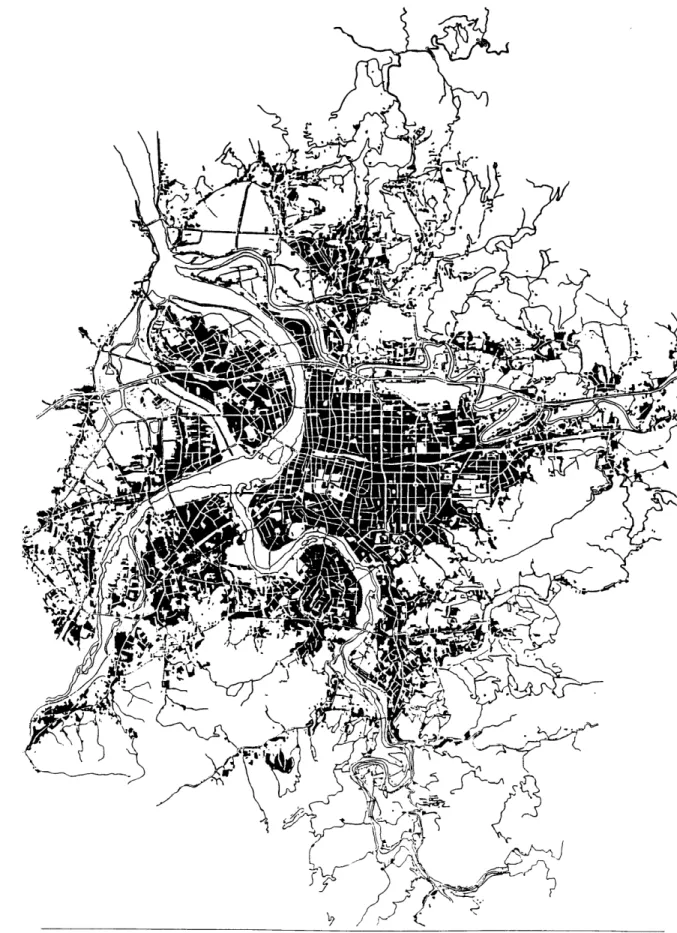
TRADITIONAL URBAN FORM VERSUS THE NEW TREND
Fig. 3.1.1 Urban fabric and superblocks in the City of Taipei
I. COMPONENTS OF
TRADITIONAL URBAN FORM
As the City of Taipei grew eastward, the
Japanese street grid was followed and
repeated until the growth was impeded by
natural obstacles. The "traditional form"
described here are therefore the products
of the Japanese planning heritage whose
time frame spans roughly the decades
between 1900 and 1970. However, the
structure of these planning strategies can
still be clearly read today. The analysis of
the urban fabric at a city-wide scale (Fig.
3.1.1) leads to the recognition of a modular
and self-supporting "unit", the typical
Taipei urban super block.
These super blocks are defined by major
city-wide thoroughfares. (Fig. 3.1.2)
They are similar in size, ranging from
400m by 500m to 500m by 600m. They
are also similar in structure. Present are
always several internal grid streets,
whose widths are narrower than the
bounding thoroughfares. The grid streets
cut into the super blocks and serve as the
major inner streets. (Fig. 3.1.3) In many
cases, these "formal" interior streets are
interwoven with winding, "informal"
ones. These organic streets trace the
routes of former agricultural irrigation
canals for rice paddies. Today, these
winding streets are very often interesting
28
Fig. 3.1.3 A major street within a superblock
Fig. A s -3.. witinasu
Fig. 3.1.4 A minor street within a superbiock
places such as street markets. As we
move into the core of a superblock, we
encounter many minor streets that run
between sub-blocks (Fig. 3.1.4), and
"back alley" spaces between buildings.
(Fig. 3.1.5)
In addition, these superblocks resemble
each other in physical profiles. According
to an old building code, the building
heights are limited to a maximum of 1.5
times the street width that the building
faces. This creates an "enclave" profile
with periphery buildings usually fronting
wider arteries surrounding a superblock.
These always possess much greater
build-ing heights, whereas the buildbuild-ings inside
the superblock are lower because of the
Fig. 3.1.5 A back alley between building
narrow streets on which they are located.
(Fig. 3.1.6)
These superblocks also exhibit parallels in their land use. The higher-rise
build-ings on the edges always offer the linear and continuous arcade spaces for street activities and functions such as com-merce, pedestrian circulation, and moped parking. The basement, first floor, even
up to the mid-height floors in these periphery buildings are used as city-wide
or district-wide commercial spaces or
offices. The ground level in the "core" part of a block is seldom arcaded; how-ever, neighborhood retail and services such as convenient stores, barber shops,
and laundry occupy the spaces in the
29
Fig. 3.1.6 The "enclave" physical profile
buildings facing major interior streets.
The floors above are exclusively
residen-tial in both periphery and core cases. As
one approaches deeper into a block, the
streets get narrower, and the spaces
become less commercial, more
residen-tial, and more private.
An hierarchical street network, an
"enclave" massing profile, vertical and
horizontal mixed-use pattern, collectively
represent the common features shared by
these Taipei superblocks. Their
similari-ties in physical form also suggest a
homogeneous social and cultural fabric in
the city. There are only a few exceptions
to this relationship between block form
and content: 1. the old wall-city and
set-tlements developed before 1895; 2.
insti-tutional blocks; 3. large-scale open
spaces; 4. the airport district; 5. the Shin
Yi new development area; and 6. areas
where the rational grid meets with the
natural boundaries.
Besides the structural, physical, and use
similarities, the superblock's
parceliza-tion and property orientaparceliza-tion also show a
simple order. Since it is considered very
desirable in Taipei to have simultaneous
street frontage and back alley access, land
sandwiched between two streets is
usual-ly divided into long, narrow strips of
parcels perpendicular to the roads.
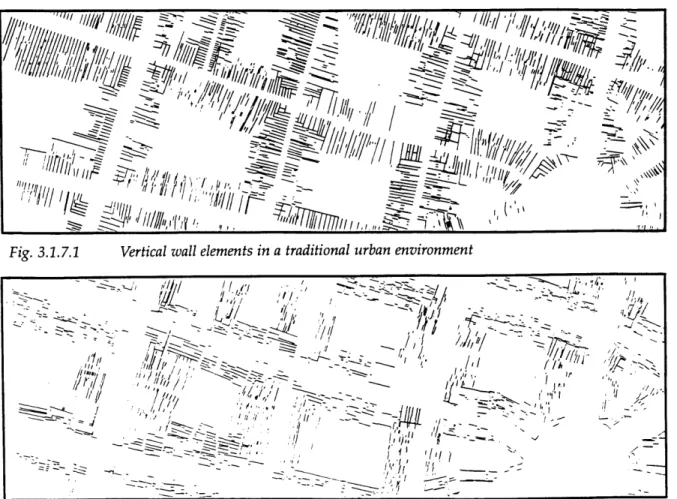
Arguing that the building walls suggest
this invisible structure, the diagram of
Fig. 3.1.7.1 Vertical wall elements in a traditional urban environment I (
~'jr;~'
7/.~§> .L
~'/ II,
$.. -j~-. h>--~.--~. I . I II '~ -~-> - -~ 4/ / -. 1 'j I, .1/ 'I, II~
I'
4L I~1
OhHorizontal wall elements in a traditional urban environment
walls perpendicular to the streets shows extreme compactness and order; (Fig.
3.1.7.1) whereas the parallel wall
dia-gram shows a random dispersion. (Fig.
3.1.7.2) The widths of these parcels often
range from 4.5m to 6m and the depths can be anywhere between 15m to 25m. This phenomenon is particularly clear in the case where the lot is fronting a major street and intensive commercial activities are expected.
The important characteristics of tradition-al urban form in Taipei are therefore: 1.
A rich and complex urban fabric of
ratio-nal grids interwoven with informal paths.
2. A strong and clear spatial hierarchy of streets. 3. Linear and vital street activities with diverse uses. 4. Simultaneous front
and back access for each dwelling unit; with the front as
formal/commercial/city-wide space and the back as informal/social/neighbor-hood space. 5. A clear relationship
between uses, building heights and their location within the hierarchy of different streets. 6. An emphasis on the spatial relationship between buildings and streets. 7. A simple and potent imple-mentation framework. 8. Similar super blocks all over the city supporting a homogeneous social and cultural fabric.
-u I 'fri
/1
I, ~i Fig. 3.1.7.231
II. THE NEW TREND
Although the traditional urban form
dis-plays a powerful physical order and
car-ries strong social connotations, the
uni-formly low-rise, low-density environment
can no longer absorb the fast growth and
development/redevelopment pressures
that the city faces. Traffic congestion in
major streets is so extreme that it flows
into the residential superblocks for short
cut and adversely effects the qualities
and functions of various paths. Car and
moped parking clogs pedestrian
side-walks, paths, and arcades. Illegal
build-ing encroachments on the ground level
erode the public space of back alleys and
street corners. Roof level additions
intrude into the orderly "enclave" profile
and the skyline.
The architectural imagery of the
"International Style" has been adopted to
tackle the development pressures exerted
on the city of Taipei. The "International
Style" has become the perfect symbol of
modernity and progress for the
Taiwanese people who use it to express a
sense of identity in the global community.
This style, as locally understood, has
meant the creation of high-rise,
articulat-ed buildings with large set-backs as
pub-lic plazas, plus large-scale green spaces
that take up the area of an entire
superblock. This wholesale adoption of
fashionable architecture and planning
principles has been further enhanced by
the private developers' advertising of
"modern" housing projects they build for
sale. (Fig. 3.2.1) The traditional forms
thus were ignored, even actively rejected,
by the common people as well as by
gov-ernment officials. Regulations were
cre-32
ated to encourage higher FAR with lower
ground coverage. Any newly acquired
land was either used for large-scale
development with monstrous buildings
(Shin-Yi Development Area) or turned
into out-of-scale parks (Park No. 7).
This new trend of development destroys
the original physical fabric. (Fig. 3.2.2)
The problems generated by the fast
growth are not solved and the new
prob-lems created by these new forms have
become increasingly apparent. Traffic
congestion increases since the high-rise
housing complexes bring in tremendous
densities in an otherwise low-density
superblock. Parking issues also become
more serious because on-street,
tempo-rary parking and
residential/under-ground parking are not integrated into
the legal requirements. Building Codes,
which have been the only regulating laws
for these developments, do not
adequate-ly address larger urban issues beyond the
building envelope. There are simply no
urban design guidelines to regulate
building-to-street relationships. Current
zoning and land uses do not correspond
to the regulated ones and various types
of commerce scattered everywhere
intro-duces messiness, noise, even nuisance
and pornography into the residential
neighborhood. The government has no
way of directly intervening since the land
prices are too high and the idiosyncrasies
of people toward their personal real
estate make land acquisition even more
difficult.
What's worse is that the social and
cul-tural impact these new physical forms
have brought onto the city have been
greatly underestimated. Social places
such as front doors, street corners, back
Calj (k 8
Fig. 3.2.2 A "new trend" high-rise housing complex
alleys, and temple plazas are
disappear-ing. Ground level activities with
hori-zontal circulation are superseded by
large-scale towers with independent
floors of spaces strung by vertical
circula-tion. Continuous "places" of the
tradi-tional urban type have been replaced by
isolated "spaces" in the new trend.
People feel disoriented and estranged in
a "modem" environment. They don't
chat with the neighbors anymore; they
don't even know the people who live
next door. The daily routine becomes
going from the apartment to the elevator
core to the lobby (if there is one) to the
messy and polluted streets to another
ele-vator core in another tower to another
unit of space. There exists no
neighbor-hood open/green spaces in residential
super blocks, no one goes to those super
block open/green spaces during daytime
because the tropical climate is too hot; no
one visits the parks at night because they
are too dangerous. Areas with high-rise
buildings and great set-backs become
dead districts and the hotbed for crimes
after dark since nobody is outside on the
streets.
Having experimented with this new
trend for almost 20 years without solving
some of the fundamental urban
prob-lems, it is about time to re-inspect the
tra-ditional treasures that we have always
had. The following content demonstrates
this effort in a design exercise for an
urban super block in the City of Taipei.
34
THE PROJECT
Fig. 4.1.1 Redevelopment potential on Taipei's east side Scale: 1/15,000
I. SITE SELECTION
From the preceding analysis we learn that there are a lot of similar blocks in the City of Taipei. I chose one super block in the eastern part of Taipei as my study site because of the following reasons:
1. Geographical Significance:
This super block is located at the eastern end of the city where the urban grids meets the natural boundaries, i.e., where the rational system is broken by the topography. This super block is the last one with an integral physical form in the eastern part of the city. (Fig. 3.1)
I
i
Transportation facility
New development/redevelopment site
The study superblock
Point of interest
MRT line
-- East-west expressway
Keelung River channelling project
Fig. 4.1.1 Legend
2. Redevelopment Potential:
Since the city started on the west side and expanded eastward much later, this super block is far less developed than other western ones and its current density is below the city's average, too. But devel-opment pressures are mounting with infrastructure improvements. Accessibility to the immediate area is increased by the expansion of the east-west expressway, and by the building of the Metropolitan Rapid Transit system (a station is planned for the edge of this super block), and the newly proposed Sun-Shan transportation
hub nearby. (Fig. 4.1.1)
3. Typological Features:
The selected super block compris-es a dominating grid road system and a winding market street. Both networks are part of a larger structure that contains for-mal and inforfor-mal typologies. (Fig. 4.1.2) This balance within the site makes it more representative as one of the typical Taipei super block and the mixture of typologies makes the study more interesting.
4. Proximity to Other
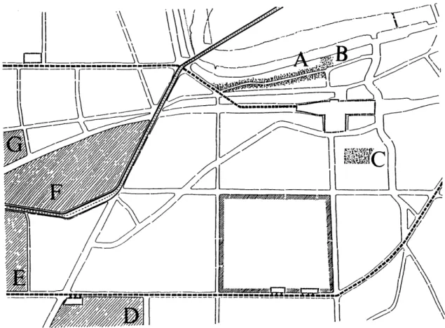
Development/Redevelopment Sites and Points of Interest. Surrounding the superblock, moving counter-clockwise, are located: (Fig. 4.1.1)
Fig. 4.1.2 Street network and spatial structure in the Sun-Shan area
A.
Rao-Ho Street night market, a famous, city-wide, night market street both for the city residents and tourists.B.
Tse-Yo Temple a Taoism tem-ple that's more than 200 years old.C.
a wholesale garment district where merchants from all over the city purchase their stock.D.
Shin-Yi Development AreaE.
Sun Yat-Sen Art District, a site is currently occupied by the Tobacco and Wine Monopoly Bureau. With theaban-donment of the monopoly system, this land will soon be available for develop-ment. The city has proposed cultural and
art facilities for the site.
F.
Rail yard redevelopment pro-ject. The rail yard has becomedevel-opable land after the railroad tracks were relocated underground few years ago. The city proposes a large-scale commercial and open space development on the site.
G.
Jing-Hwa commercial devel-opment district; an extensive financial and commercial complex, Wei-Jing Project, is proposed for the site, which is owned by the Taiwanese financial com-pany Jing-Hwa Cooperation.40
This is an ideal site to demonstrate that traditional urban form and urban design principles applied to the contemporary city would generate a much higher
quali-ty of life by connecting the past with the present and the future. The currently typical "modem" approaches fail to pro-vide a sense of continuity of urban form and urban life.
.
.1
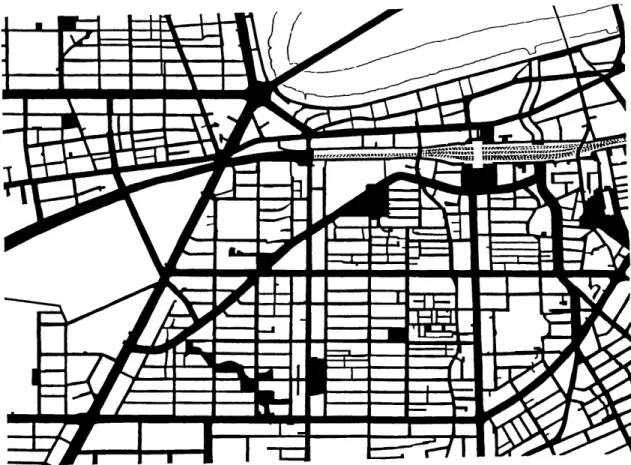
Fig. 4211 Study superbiock base map scale: 1/6,000
II. SITE ANALYSES
42
In this section, diagrams are used to
explore different layers and aspects of
urban information contained in the study
superblock. These readings serve as thefoundation upon which the re-design
proposals are based.
I
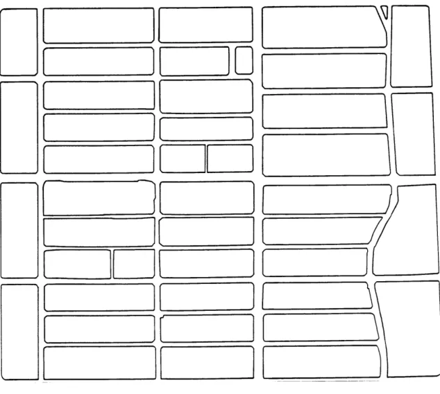
Fig. 4.2.1.2 Base drawing of blocks Scale: 1/4,000
1. The Super Block Today:
(Fig. 4.2.1.1, 4.2.1.2, 4.2.1.3, 4.2.1.4) The site is a microcosm of a much larger grid system which organizes the city. Divided into four quadrants by a pair of major interior cross streets, the super block is then cut into smaller rec-tangular blocks with an east-west direc-tion. These blocks range in size from 35m by 120m to 45m by 150m in the "core" and 45m by 110m to 55m by 150m
0W~
o
2 O: FEZ
W
[TmmrF71
~Lf
Scale: 1/4,000at the "edge". The depths of the core
blocks provide enough space for two
rows of residential buildings separated
by a narrow alleyway, so that each
build-ing enjoys the preferred north/south
ori-entation and benefits from front and
back access. At the edges, the block
depths are very often 10m larger,
provid-ing enough room for larger-scale or
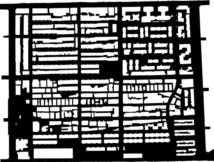
Fig. 4.2.1.3 Base drawing of building footprints44
O__C=0~Ff
00
j
to~
Kbaod2~~I=
C
DO __0_BD
It
t
12A, 4
/26mLf45
Fig. 4.2.1.445
higher-rise development. The blocks on the periphery therefore form a band of larger buildings that wraps around the block and separates the core from the outside of the block.
//5m--/22m-6 b
-U
mi-
'
U-...---
IM
Ela
~
-an
-ass
-
i
'-es~s
=
--Ear
--...
mas
Scale: 1/4,0002. Figure Ground Readings: (Fig. 4.2.2.1., 4.2.2.2)
The figure-ground drawing illus-trates that some "new trend" develop-ment has already taken place in the cor-ners of the north-eastern quadrant. These articulated buildings cut the unbuilt areas into scattered spaces, which function more like light wells for these high-rise towers than neighborhood places. The inner part of the north-east-ern quadrant and most of the north-west-ern quadrant are both occupied by long rows of apartment buildings. The
circu-.
-Fig. 4.2.2.1 Figure ground
46
m
-EWMW
M
--
A
m
...
=
-assa
Fig. 4.2.2.2 Reverse figure ground Scale: 1/4,000
lation cores very often protrude out of the long rectangles and invade the integrity of the linear spaces in front of
them. These long boxes always run east-west and turn their sides to the
north-south streets. The back lanes between two built bands are too narrow and long in proportion that the ground level resi-dents either block them and build illegal encroachments to claim the land and to discourage any possible through-traffic;
in other words, these back alleys were never used as real "places." In the two southern quadrants, the urban fabric gets finer and more interesting with various types of spaces and built forms. The loca-tion of social gathering places becomes evident. However, certain paths get too fine in scale that they become useless.
Fig. 4.2.3 .1.1 The first and second hierarchy of superblock paths
3. Street Structure and Hierarchy: The previous section illustrates the important role played by different hierarchies of streets and paths in orga-nizing and structuring the city. From the following diagram analyses, I find there are roughly four levels of paths which vary in scale and functions.
The highest level comprises paths that provide city-wide vehicular access to the super block. These thoroughfares also define the boundaries of a super block and generally have a width of 30m.
(Fig. 4.2.3.1.1)