HAL Id: hal-03015968
https://hal.archives-ouvertes.fr/hal-03015968
Submitted on 20 Nov 2020HAL is a multi-disciplinary open access
archive for the deposit and dissemination of sci-entific research documents, whether they are pub-lished or not. The documents may come from teaching and research institutions in France or abroad, or from public or private research centers.
L’archive ouverte pluridisciplinaire HAL, est destinée au dépôt et à la diffusion de documents scientifiques de niveau recherche, publiés ou non, émanant des établissements d’enseignement et de recherche français ou étrangers, des laboratoires publics ou privés.
Peninsula Shown by Sedimentary Provenance
Samuel Shekut, Alexis Licht
To cite this version:
Samuel Shekut, Alexis Licht. Late Middle Miocene Emergence of the Olympic Peninsula Shown by Sedimentary Provenance. Lithosphere, Geological Society of America, 2020, 2020 (1), pp.1-20. �10.2113/2020/7040598�. �hal-03015968�
Research Article
Late Middle Miocene Emergence of the Olympic Peninsula
Shown by Sedimentary Provenance
Samuel Shekut
1and Alexis Licht
1,21Department of Earth and Space Sciences, University of Washington, Seattle, WA 98195, USA
2Centre Européen de Recherche et d’Enseignement des Géosciences de l’Environnement (Cerege), UMR CNRS7330,
13545 Aix-en-Provence, France
Correspondence should be addressed to Samuel Shekut; sjshekut@gmail.com Received 29 January 2020; Accepted 19 September 2020; Published 6 November 2020 Academic Editor: Tamer S. Abu-Alam
Copyright © 2020 Samuel Shekut and Alexis Licht. This is an open access article distributed under the Creative Commons Attribution License, which permits unrestricted use, distribution, and reproduction in any medium, provided the original work is properly cited.
The Olympic Peninsula is the uplifted portion of the Cascadia accretionary wedge and forms the core of a 200 km scale oroclinal bend on the west coast of Washington State. The accretionary wedge started forming 45 million years ago following the accretion of the Siletzia igneous province along the Cascadia subduction margin. Low-temperature thermochronology studies have shown that the core of the peninsula has been continuously exhumed for the last 14 million years. The earlier onset of oroclinal bending, uplift, and emergence remains poorly documented. Here, we explore the Cenozoic drainage history of the Cascadia forearc and accretionary wedge to reconstruct the deformation history of the Olympic Peninsula. We use detrital zircon provenance and grain petrography data from modern rivers draining the Cascades, the Cascadia forearc and accretionary
wedge, as well as from Eocene to late middle Miocene sedimentary units from the same areas. Wefirst show a clear difference of
sedimentary provenance between sedimentary units in the accretionary wedge, with older units reflecting mélange and
imbricated strata that began as part of Siletzia, and younger units reflecting trench-fill material sourced from the Cascades and
accreted to the wedge. We show that the accretionary wedge was directly fed from the Cascade arc until at least 16:5 ± 0:5 Ma,
providing a maximum age for the emergence of the Olympic Peninsula. Fluvial deposits in the Cascadia forearc basin dated at 13:3 ± 1:3 Ma display zircon age spectra and sedimentary grain petrography features typical of recycled accretionary wedge material. Although these deposits may also reflect local input, middle Miocene exhumation rates suggest the Olympic Peninsula was an active sediment source. Our results bracket the timing of emergence of the Olympic Peninsula to a narrow window in the late middle Miocene. We suggest that the initial onset of accretionary wedge deformation and oroclinal bending predates
this by at least 10 million years, in the upper Oligocene, and is marked byflexural subsidence and high sedimentation rates
recorded in strata of the Seattle Basin. Our results support a composite history for the development of the Cascadia accretionary wedge rather than models predicting a gradual and steady build-up.
1. Introduction
The Olympic Peninsula of Western Washington State is the subaerially exposed portion of the Cascadia accretion-ary wedge [1, 2], which developed following the Eocene accretion of the Siletzia igneous province along the west coast of North America [3, 4]. Substantial deformation and uplift of the Cascadia accretionary wedge have resulted in a large oroclinal bend with the Olympic Moun-tain range at its core [5]. These mounMoun-tains are unique in
that they are larger and higher than all other coast
moun-tain ranges formed by accretionary wedges on the Pacific
Coast of North America. Low-temperature thermochronol-ogy studies have shown that the core of the peninsula has been continuously exhumed for the last 14 million years, though the tempo and evolution of exhumation rates through recent times remain debated [1, 6–10]. Rock uplift has been proposed to be driven by crustal thickening related either to margin-parallel shortening [11], frontal accretion [7, 10], or underplating at the trench [12]. High
Volume 2020, Article ID 7040598, 20 pages https://doi.org/10.2113/2020/7040598
precipitation rates along the coast enhance exhumation, contributing to the shape and rate of uplift [13].
The actual timing of surface uplift of the accretionary wedge remains virtually undocumented. It is unclear when the accretionary wedge started forming a submarine high, creating a topographic barrier between the Cascadia trench
and the forearc, and when the peninsula finally emerged.
Documenting the chronology of these events is essential to
reconstruct sedimentary fluxes into the trench, to
under-stand how fast exhumational steady state was reached in the Olympic Mountains, and to identify the main drivers of rock uplift [12].
Here, we use detrital zircon provenance and sandstone petrography to place age constraints on the uplift and sub-aerial exposure of the Olympic Mountains. We use U-Pb zircon ages and petrographic data from modern rivers of the Olympic Peninsula and the North Cascades to determine the provenance character of modern drainages. We then use the same methods on Cenozoic sedimentary rocks of the Cascadia forearc and accretionary wedge to reconstruct the regional drainage history and track the emergence of the Olympic Mountains as a topographic high.
2. Geologic Setting
2.1. The Olympic Peninsula. The Cascadia accretionary wedge, Cascadia forearc, and the Cascade Range run parallel to the Cascadia subduction zone, where the Gorda and Juan de Fuca Plates subduct beneath the North American Conti-nental Plate. The Olympic Peninsula is the portion of the Cascadia accretionary wedge that sits on the west coast of Washington State, separating the Puget Lowland from the Pacific Ocean with a high mountain range. The Puget Low-land is the portion of the Cascadia forearc in Washington, which is bounded by the Olympic Peninsula to the West and the Cascade Range to the East, draining sediment from both. In Canada, the forearc forms the Georgia Basin, bounded by Vancouver Island to the West and the Coast Mountains to the East, the northward continuation of the
Cascade Range (Figure 1). Reference to“the Cascades” in this
manuscript specifically regards the North Cascades that extend from Central Washington to southern British Columbia. The Cascades comprise an exhumed metamor-phic core, Mesozoic to Eocene plutons—the Coast
Moun-tains Batholith—and an Andean-type volcanic arc that has
been active since the middle Eocene—the Cascade Arc [14].
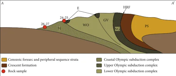
The seminal study of Tabor and Cady [2] provides detailed structural and geological description of the Olympic Peninsula and has guided all other studies to follow. The pen-insula is composed of two primary terrains: peripheral rocks that comprise early Eocene basalts of the Crescent Formation overlain by little-deformed Eocene to Miocene, mostly marine sedimentary rocks, and a core of extensively deformed marine sedimentary rocks called the Olympic sub-duction complex (OSC) by Brandon and Calderwood [1].
The Crescent Formation is in fault contact with the OSC along the Hurricane Ridge Fault, wrapping around the east of the Olympic Peninsula to form a crescent shape (Figures 1 and 2; [15]). The Crescent Formation comprises
primarily thick basal pillow and columnar basalts overlain by felsic volcaniclastic sandstones, lignite, and mudstones
[16]. K-Ar hornblende dating, 40Ar/39Ar whole rock ages,
and U-Pb dating of felsic tuffs constrain the eruption of
the Crescent Formation to between 53.2 and 48.4 Ma [4, 17]. Some have proposed slab window volcanism as a result of ridge subduction to be the source of the Crescent Basalt [18, 19]. An alternative hypothesis has linked the Crescent
Formation to a flare-up of the long-lived Yellowstone
hot-spot that resulted in the eruption of a marine large igneous province [4, 20, 21]. The latter model groups together con-temporary basalts from Oregon, Washington, and British Columbia, including the Crescent Formation, into the Siletzia terrane; the Siletzia terrane would have erupted as a marine large igneous province, forming a submarine pla-teau on the Farallon plate before being accreted to North America in the early Eocene [4, 17]. Regardless of which model for the origin of the Crescent Formation is the most accurate, the grouping of the Siletzia terrane and accretion
timing are well agreed upon. In this manuscript, “Siletzia”
is used to refer to the entire accreted terrane, and“Crescent
Formation” is used in reference to rocks of the Siletzia ter-rane that crop out in Western Washington.
Thefirst marine sediments were accreted to the Cascadia
accretionary wedge beneath the Siletzia terrane in the Eocene, following the initiation of the Cascadia subduction
zone, which caused significant slip along the Hurricane Ridge
Fault (tens of kilometers; [7]). The initiation of the Cascadia subduction zone is dated at ca. 42-45 Ma based on the age of the oldest post-Siletzia accretion magmatic rocks in the Cascade Arc [14, 22]. The accreted sedimentary rocks that have been underthrust beneath the Crescent Formation form the core of the Olympic Peninsula today, and they have been thoroughly mapped [2, 15]. These rocks were initially divided
into five informal lithic assemblages: the Hoh, Elwha,
Western Olympic, Grand Valley, and Needles-Gray Wolf assemblages (Figure 2; [2]). Although these rocks have been mapped with high precision, the extreme amount of
defor-mation and displacement has made it difficult to discern
stratigraphic relationships between the five assemblages; in
general, the rocks become younger from East to West [2, 15, 23]. Brandon and Vance [23] grouped rocks of the Cascadia accretionary wedge into the Olympic subduction
complex (OSC) and reorganized the five lithic assemblages
into three structural units using thermochronological and structural data: the coastal OSC, equating to the Hoh assem-blage; the lower OSC, grouping the Western Olympic and Grand Valley assemblages; and the upper OSC, grouping the Needles-Gray Wolf and Elwha assemblages (Figure 2; [23]). Stratigraphic and chronologic relationships between
these structural units are not clearly defined; biostratigraphic
ages for the OSC range from Eocene to upper Miocene, and generally the oldest ages are found in the upper OSC and the youngest in the coastal OSC [24].
The upper OSC is the structurally highest unit of the OSC, and it is interpreted to be the oldest [23]. The upper OSC locally contains pillow basalts that are composition-ally similar to the Crescent Formation and are interbedded with fossiliferous limestones that yield latest Paleocene to
Quaternary volcanic rocks Crescent formation
Neogene and older volcanic rocks Neogene and older intrusive igneous rocks Metamorphic and pre-mesozoic strata Modern river sample
Quaternary sediment Cenozoic and Mesozoic strata Lower Olympic subduction complex
Rock sample
Upper Olympic subduction complex Coastal Olympic subduction complex
Mt. Olympus Seattle 0 0 40 mi 50 km 26-27 20-21 10-11 22 HRF 15-19 13-14 9 7 86 5 3 1 2 4
Strait of Juan De Fuca
12 23 24 25 A A′ GB GM SFZ OM PL CaR CoR CM
Figure 1: Regional geologic map of the Olympic Peninsula, Puget Lowland, and the eastern extent of the North Cascades (modified from [7, 94]). Sample locations are shown by red dots (rock outcrop) and blue dots (river sands) with sample numbers labelled (see Table 1 for sample numbers). HRF = Hurricane Ridge Fault; SFZ = Seattle Fault Zone; GM = Green Mountain; CaR = Cascades Range; CM = Coast Mountains; CoR = Coastal Ranges; OM = Olympic Mountains; PL = Puget Lowland; GB = Georgia Basin. Paths of major rivers are shown by blue lines.
middle Eocene fossil ages [15, 24]. Detrital zircons from
this unit have yielded fission-track maximum depositional
ages ranging from early Eocene to early Oligocene (48-32 Ma; [23]). Some localities attributed to the upper OSC yield upper Eocene to lower Miocene microfossils [25, 26]. The lower OSC is distinguished from the upper OSC by the absence of pillow basalts, and only comprises marine clastic sedimentary rocks including turbidite sequences and highly deformed mudstone-rich mélanges. It structurally underlies the upper OSC. Detrital zircons from this unit have
yielded fission-track maximum depositional ages ranging
from 27 to 19 Ma [23, 27].
The coastal OSC is the structurally lowest unit of the OSC and is lithologically similar to the lower OSC [23];
the two units are differentiated by the higher degree of
meta-morphism observed in the lower OSC [2, 23]. Detrital zircons from turbidites of the coastal OSC have yielded fission-track maximum depositional ages ranging from 26 to 11 Ma; mélange blocks have yielded maximum deposi-tional ages ranging from 39 to 15 Ma [27]. The youngest fission-track ages, however, display high uncertainties (2 s ± 3 to 4 Ma; [27]).
The three units of the OSC have been attributed differ-ent sedimdiffer-ent sources and accretionary histories, though lit-tle work has been done to quantify these differences [23]. It has been interpreted that the lower OSC represents sed-iment drained from the Cascades into the subduction trench, while the coastal OSC represents mass wasting of material from the continental slope, with these two units constituting the true accretionary wedge [23, 27]. Brandon and Vance [23] propose that early Eocene deposits of the upper OSC originated as the westernmost clastic strata of the Siletzia terrane. These strata were imbricated and underthrust beneath the Crescent Formation following the initiation of the Cascadia subduction zone. Brandon and Vance [23] also propose that this imbrication could not have occurred until after deposition of the youngest strata of the upper OSC (~33 Ma), which is several million years later than the proposed slip event along the
Hurricane Ridge Fault and initiation of subduction (~45 Ma; [7, 14]).
Detrital apatite and zirconfission-track and (U-Th)/He
ages from the core of the peninsula show continuous exhu-mation since at least 14 Ma [7–9, 23, 28]. The exhuexhu-mation of the OSC has created a wide oroclinal bend, resulting in the arcuate shape of the Crescent Formation [5]. It has been proposed, based on regional-scale plate motion and GPS data, that this oroclinal bend and the unusual elevation of the OSC is caused by margin-parallel motion, which contrib-utes to uplift, with the Olympic Peninsula caught between the northward motion of the Oregon Coast Range and the relatively stable Vancouver Island [11, 29–31]. This margin-parallel motion is evidenced by the numerous south-east- and northsouth-east-striking oblique-slip faults that accom-modate trench-parallel shortening and westward block extrusion within the Olympic Peninsula [32–34].
Alternatively, it has been proposed that uplift and orocl-inal bending are generated by margin-normal deformation resulting from accretion along the wedge [10, 28]. It has been estimated that 80 to 100% of the sediment from the subduct-ing Juan de Fuca Plate is accreted to the wedge front, and that
this accretionary flux is in equilibrium with exhumation
rates, with accreted material horizontally traversing most of the wedge before being exhumed [1, 28]. The presence of low-grade metamorphic rocks at high elevations in the Olympic Mountains shows that accretion is likely comple-mented by underplating of accreted sediment driving
mate-rial flow upwards within the wedge [1, 7]; however, the
contribution of this underplating component remains debated [10, 12]. For these scenarios, the greater elevation of the Olympic Peninsula compared to southern parts of the Cascadia wedge is explained by the concavity of the North American margin where the Juan de Fuca plate sub-ducts beneath Washington; the curvature of this contact forces the underriding slab into an antiformal configuration, shallowing the slab dip beneath the Olympic Peninsula and driving margin-normal shortening and underplating [1, 35,
36]. High sedimentation rates at the trench in the Pacific
Lower Olympic subduction complex Coastal Olympic subduction complex Upper Olympic subduction complex Crescent formation
Cenozoic forearc and peripheral sequence strata H E WO GV NG 26-27 24-25 Rock sample HRF PS A A′
Figure 2: Schematic cross section showing generalized structure of Olympic Peninsula (A‐A′ line on Figure 1), informal lithic assemblages, and corresponding members of the OSC. H = Hoh; WO = Western Olympic; GV = Grand Valley; E = Elwha; NG = Needles-Gray Wolf; PS = Peripheral Sequence; HRF = Hurricane Ridge Fault.
Northwest could also have amplified accretion rates and underplating [7].
Margin-normal and margin-parallel drivers on orocl-inal bending are nonexclusive and both could have con-tributed to shaping the Olympic Peninsula, either at the
same time or at different periods. For both types of
drivers, the onset of deformation is commonly associated with the beginning of basin and range extension in the middle Miocene; this extension would have changed block motion along the North American margin and enhanced its curvature [1]. Early low-temperature thermochronology studies have suggested that exhumation in the core of the peninsula has been fairly constant at a rate of 0.75 to 1 mm/yr since 14 Ma and is at accretionary steady state [7, 23, 28]. More recent studies have highlighted a more complex exhumation story, with initially high (>2 mm/yr) exhumation rates followed by a sharp decrease to values
< 0:3mm/yr at ~5-7 Ma, coeval to a lowering in
conver-gence rates [9]. Exhumation rates were later increased with the onset of Plio-Pleistocene glaciation [8, 9].
While it is established that the core of the peninsula has been steadily exhumed since at least 14 Ma, the timing of the initiation of uplift remains poorly understood. It is unknown when the accretionary wedge started forming a submarine topographic high, which is critical to understand sediment transfer from the arc to the trench and the distribu-tion of deformadistribu-tion along the subducdistribu-tion margin [37]. It is also unclear when the Olympic Peninsula became subaerially
exposed, confining the Puget Lowland and allowing fluvial
erosion to significantly increase exhumation rates.
Brecciation and quartz veining in low-grade metamor-phic rocks in the Olympic core dated at 17 Ma may be asso-ciated with early exhumation [38]. Using an assumption of a depth of accretion at 14.5 km, a constant exhumation rate
of 0.75 km/Myr, and a geothermal gradient of 4.4°C/km,
Brandon et al. [7] combined zircon and apatitefission-track
ages to calculate that exhumation of the core of the Olympic Mountains should have begun at ca. 18 Ma. Uplift of the Olympic Peninsula resulted in the deformation and further partitioning of the Cascadia forearc basin into smaller subba-sins, a process that had begun after collision with the Siletzia terrane [17]. This uplift could be reflected in the angular unconformity between 22 and ~13 Ma found in the Seattle Basin [39, 40], or the younger angular unconformity between 7.5 and 6 Ma in the Astoria Basin [41]. Bigelow [42] used sed-imentary grain petrography to characterize the provenance of the upper Miocene Montesano Formation of Southwest Washington and Northwest Oregon to support the claim that the Olympic core and Crescent Formation had been uplifted and emerged by 10 Ma. There are no other, more precise con-straints for the age of uplift and emergence of the Olympic Mountains, particularly in Northwest Washington near the highest peaks of the range.
2.2. Stratigraphy of the Cascadia Forearc. Before the accretion of Siletzia, Western Washington hosted the Swauk Basin, a large nonmarine sedimentary basin into which the several
kilometer-thick Chuckanut Formation was deposited
between 60 and 51 Ma (Figure 3; [17]). Well exposed along
the coast near Bellingham, Washington, the Chuckanut For-mation consists of 6 members: the Bellingham Bay, Slide, Governer’s Point, Padden, Warnick, and Maple Falls Members, in stratigraphic order [43]. The Chuckanut For-mation consists of coarse sandstones and conglomerates,
mudstones and siltstones, and abundant coal [43–45]. The
sedimentary provenance of the Chuckanut Formation has been thoroughly studied and shows a composite history for the unit. The Bellingham Bay and Slide Members have been proposed to be sourced by sediment from the metamorphic core of Eastern Washington, transported by large, competent fluvial systems, which decreased in size through time [43]. The Padden Member contains abundant chert pebbles and is likely derived from the Western mélange belt (WMB)—a large belt of Jurassic to Cretaceous mélange that was accreted to North America in the Late Cretaceous and today is exposed in the foothills of the Cascades [46]. The Warnick and Maple Falls Members are more likely sourced from uplift at the northern portion of the Swauk Basin, and they
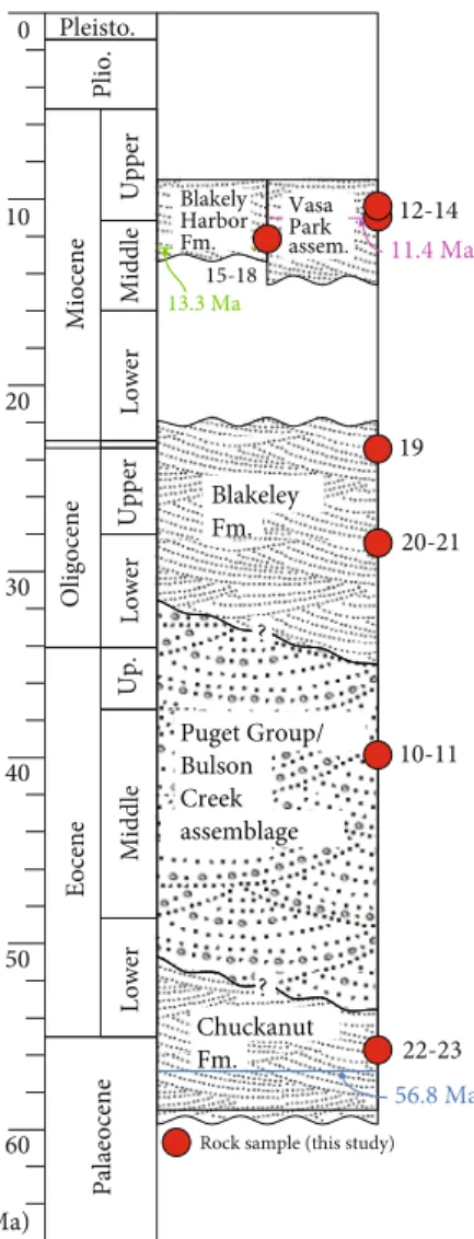
Chuckanut Fm. Puget Group/ Bulson Creek assemblage Blakeley Fm. Pleisto. Plio. Miocene Upper Middle Lower Oligocene Eocene Up. Middle Upper Lower 10 20 30 0 40 50 60 Lower Palaeocene (Ma) 22-23 10-11 20-21 19 12-14 15-18 Blakely Harbor Fm. Vasa Park assem.
Rock sample (this study) 11.4 Ma 13.3 Ma
56.8 Ma
?
?
Figure 3: Composite stratigraphic column displaying age relationships of units from the Cascadia forearc sampled for this study. Stratigraphic locations of samples are shown and sample numbers are labeled (see Table 1 for sample numbers). Important age constraints are labeled (see main text for references).
comprise interfingered alluvial fan deposits [17, 44]. Strike-slip faulting in the Swauk Basin began at 51 Ma resulting from collision of Siletzia with North America [4, 17]. Subse-quent faulting caused large-scale deformation of the Chuckanut Formation and partitioning of the Swauk Basin throughout the Eocene [43]. The faulting and deformation of the Chuckanut Formation have obscured the top of the section, and stratigraphic relationships with adjacent strata are difficult to discern.
Middle Eocene to early Miocene forearc deposits that postdate deposition of the Chuckanut Formation and accre-tion of Siletzia have been given various local names; they are grouped under the Puget Group within the Puget Low-land [47], and under the Northern and Southern Peripheral sequences north and south of the Olympic Peninsula, respectively [48]. The Puget Group commonly comprises
lignite-bearing fluviodeltaic and shallow marine deposits,
interfingered with volcaniclastic sandstones [49]. In the Lake
McMurray area near Mt. Vernon, Washington, 1500 m of these deposits have been given the informal name of the Bul-son Creek assemblage (Figure 3; [45]). The northern and southern Peripheral Sequences are dominated by deeper marine facies [48].
Further South in Puget Lowland, in the Seattle Basin, Oligocene to Miocene deposits are particularly thick
(>7 km). Thickening in this region is explained by local
flex-ural loading along the Seattle Fault Zone (SFZ; [50, 51]). The SFZ consists of multiple east-trending, north-verging thrust faults, which accommodate northward shortening inboard of the Olympic massif [52]; it merges further west with the northeast-striking oblique-slip fault system that accommo-dates trench-parallel shortening within the Olympic Peninsula [33, 34]. The timing of onset of SFZ activity and
associated flexural loading is debated. Johnson et al. ([50],
1998) propose a late Eocene to Oligocene age for the initia-tion of the Seattle Fault; this interpretainitia-tion is supported by
a single apatitefission-track age of 32 ± 5 Ma obtained from
the Green Mountain area in the Seattle Fault hanging wall [53]. By contrast, ten Brink et al. [51] date the onset of the Seattle Fault to the early to middle Miocene based on seismic reflection data.
The upper Oligocene-lower Miocene Blakeley Formation in the Seattle Basin is commonly distinguished from the Puget Group as it is dominated by deeper marine facies [54]. Deposited between 32 and 22 Ma, the Blakeley Forma-tion is divided into two members: the lower Orchard Point and the upper Restoration Point Members [39], both repre-senting submarine fan deposition [54]. The Orchard Point Member, which is well exposed along the Sinclair Inlet and along Alki Beach in Seattle, is a coarse clastic sandstone with
local siltstones andfine sandstones, and one layer of
tuffa-ceous clay-shale [39]. The Restoration Point Member is well
exposed on the south of Bainbridge Island and is finer
grained, withfine sandstones, abundant siltstones and shales,
and rare pebbly sandstone layers [39]. The top of the Blakeley Formation is marked by an angular unconformity [55].
Sitting atop the unconformity that caps the Blakeley For-mation is the Blakely Harbor ForFor-mation, which is well exposed along the Southern beaches of Bainbridge Island
[39, 55]. While this contact is not expressed at the surface, it has been well documented with subsurface imaging [51].
A zircon fission-track age at 13:3 ± 1:3 Ma from a tephra
layer near the base of the Blakely Harbor Formation and a middle Miocene pollen assemblage give a late middle Mio-cene age for the base of the unit [40]. The Blakely Harbor
Formation is made of coarsefluvial and overbank deposits,
composed of clastic, basalt-rich sandstones and conglomer-ates interbedded with claystone and siltstone, and is locally rich in organic matter [39]. The numerous basalt clasts found in the Blakely Harbor Formation have been attributed to ero-sion of the Crescent Formation as a sediment source [39].
Further east within the Seattle Basin, a sequence of sedi-mentary rocks, contemporary with the Blakely Harbor For-mation, crops out in ravines within Vasa Park [56]. Some have considered these strata part of the Blakely Harbor For-mation [40]; however, we refer to this section informally as the Vasa Park assemblage. The Vasa Park assemblage con-tains two lithofacies: pebbly conglomerate containing
andes-itic and felsic volcanic cobbles, and tuffaceous sandy siltstone
and silty sandstone rich in organic matter [56]. K-Ar ages of
tuffs constrain deposition of the assemblage to between 14.7
and 9.3 Ma, though the extremely low radiogenic argon con-tent of these samples (8%) leaves high uncertainty [57]. A
more recently acquired 40Ar/39Ar age dates the middle of
the assemblage to 11:40 ± 0:61 Ma [58].
3. Methods
Sediment samples were collected from several modern rivers in the Washington Cascades and Olympic Peninsula as well
as sedimentary rock samples from turbidites and fluvial
sandstones in the Puget Lowland and on the Olympic Peninsula. Sample locations, determined with a handheld GPS, are shown in Figure 1 and labeled in Table 1. We collected samples of 1 to 5 kg of medium to coarse sand from sand bars of the following modern rivers: the Skykomish, Puy-allup, Skagit, and Snoqualmie rivers, which drain the Cascades into Puget Sound; the Hoh, Elwha, Bogachiel, and Queets riv-ers, which drain the Olympic Peninsula into the Pacific Ocean and the Strait Juan de Fuca; and the Columbia River, which drains Eastern Washington State into the Pacific Ocean.
Sedimentary rock samples were collected from medium
to coarsefluvial sandstones and turbidites, and samples were
cleaned to avoid contamination from nearby quaternary allu-vium. In the Olympic Peninsula, we collected two samples of the coastal OSC from Kalaloch Beach, mapped as lower to middle Miocene [25]. We collected one sandstone from the upper OSC at Shi Shi Beach, just South of a block of Eocene pillow basalt that correlates to the Crescent Formation, in turbidites attributed to the upper Eocene-Oligocene [26]. We collected a second sandstone of the upper OSC at Second Beach just south of La Push, Washington, from a local mélange attributed to diapirism and considered as being upper Eocene to lower Miocene in age [25].
In the Puget Lowland, we collected two samples in the Bellingham Bay Member of the Chuckanut Formation. We collected two samples of the Bulson Creek assemblage from the upper lithofacies described by Marcus [45]; one
sample of the Blakeley Formation from the Restoration Point Member on Bainbridge Island; two samples from the Orchard Point Member where it crops out on Alki Beach in Seattle [39, 55]; four samples from the Blakely
Harbor Formation on Bainbridge Island near the 13:3 ±
1:3 Ma tephra layer reported by Sherrod [40]; and three
samples from the Vasa Park assemblage close to or at the locality described by Dillhof et al. [56], where a
40Ar/39Ar age of 11:4 ± 0:6 Ma is reported [58].
In total, we collected samples from 9 modern rivers and 18 rock outcrops. All samples but two were analyzed for grain petrography. For each modern river sample, a small fraction
of collected sediment was mounted in synthetic resin. For
each hard-rock sample, a small ( ~ 1:5 × 3 cm) fragment
was cut and prepared as a thin section. Petrographic results were acquired on these thin sections using the Gazzi-Dickinson method to discern the relative abundance of quartz, feldspar, and lithic grains in each sample [59]. All pet-rographic data and GPS locations of the samples are available in Supplementary Table 1.
All samples were analyzed for detrital zircon provenance; analytical set-up is presented by Licht et al. [60], and the complete procedure is detailed in Supplementary File 1. Zircons were extracted by traditional methods of heavy Table 1: Maximum depositional ages (MDA) calculated for every sample. n: number of zircon ages; MSWD: mean square weighted deviation.
Sample # Sample name (and river) MDA ± 2 s uncertainty Sample location
Cascade rivers
1 19-SNOR-01 (Snoqualmie) 18:5 ± 0:5 Ma (n = 19, MSWD = 0:8) Three Forks Natural Area
2 18-CASCR-01 (Skykomish) 20:8 ± 0:7 Ma (n = 1) Sultan, WA
3 18-CASCR-02 (Puyallup) 0:27 ± 0:21 Ma (n = 3, MSWD = 3:9) Puyallup, WA
4 18-CASCR-03 (Skagit) 0:15 ± 0:04 Ma (n = 12, MSWD = 1:8) Minkler, WA
Olympic rivers
5 18-ELWA-01 (Elwha) 23:9 ± 1:6 Ma (n = 1) Maddison Falls Trailhead
6 19-BOGR-01 (Bogachiel) 23:5 ± 1:8 Ma (n = 1) Bogachiel State Park
7 19-QUER-01 (Queets) 20:3 ± 1:1 Ma (n = 1) Near Clearwater Rd.
8 18-HOHR-01 (Hoh) 24:3 ± 2:4 Ma (n = 3, MSWD = 3:9) Near Allens Bar Campground
Columbia River
9 18-COLR-01 (Columbia) 0:072 ± 0:09 Ma (n = 4, MSWD = 2:8) Cape Disappointment State Park
Bulson Creek assemblage
10 18-BLC-01 48:2 ± 3:4 Ma (n = 3, MSWD = 1:7) Lake McMurray, WA
11 18-BLC-02 29 ± 0:8 Ma (n = 41, MSWD = 1:2) Lake McMurray, WA
Vasa Park assemblage
12 18-RNT-01 12:3 ± 0:3 Ma (n = 40, MSWD = 1:3) Lakemont Park
13 18-VAP-01 11:8 ± 0:3 Ma (n = 30, MSWD = 1:2) Vasa Park
14 18-VAP-03 11:1 ± 0:3 Ma (n = 50, MSWD = 1:2) Vasa Park
Blakely Harbor Formation
15 17-BLH-02 29:8 ± 1:5 Ma (n = 4, MSWD = 1:5) Bainbridge Island 16 18-BLH-01 22 ± 0:9 Ma (n = 1) Bainbridge Island 17 18-BLH-02 28:8 ± 1:5 Ma (n = 1) Bainbridge Island 18 18-BLK-02 30 ± 0:8 Ma (n = 32, MSWD = 1) Bainbridge Island Blakeley Formation 19 18-BLK-01 26:6 ± 0:9 Ma (n = 3, MSWD = 0:1) Bainbridge Island 20 19-BLK-01 26:1 ± 0:7 Ma (n = 4, MSWD = 0:7) Alki Beach 21 19-BLK-02 22:8 ± 0:7 Ma (n = 4, MSWD = 0:7) Alki Beach Chuckanut Formation
22 18-CHK-01 65:1 ± 2 Ma (n = 11, MSWD = 1) Larrabee State Park
23 18-CHK-02 59:3 ± 2:4 Ma (n = 1) Larrabee State Park
Upper OSC
24 19-OSC-01 82:1 ± 2:9 Ma (n = 1) Second Beach
25 19-OSC-02 41:3 ± 1:4 Ma (n = 1) Shi Shi Beach
Coastal OSC
26 18-HOH-01 16:7 ± 0:5 Ma (n = 6, MSWD = 1) Kalaloch Beach
mineral separation, including concentration with a Holman-Wilfley™ gravity table, density separation with methylene iodide, and magnetic separation with a Frantz™ Magnetic Barrier Separator. U-Pb ages were generated using laser-ablation inductively coupled-plasma mass-spectrometry (LA-ICP-MS), using an iCAP-RQ Quadrupole ICP-MS coupled to an Analyte G2 excimer laser at the University of
Washington, using a spot diameter of 25 microns and Ple
šo-vice zircons as calibration reference material [61]. Data reduction was conducted with Iolite (Version 3.5), using their U_Pb_Geochron4 Data Reduction Scheme to calculate U-Pb dates uncorrected for common lead [62]. In addition, date uncertainties for all samples were calculated using a modified version of the method of Matthew and Guest [63], imple-mented in MATLAB, that takes into account the impact of
207Pb beam intensity on date uncertainties [64]. The dates
used for plotting and in the discussion are 206Pb/238U for
dates < 1400 Ma and207Pb/206Pb for dates > 1400 Ma. Dates > 300 Ma were screened for concordance using a
discor-dancefilter at >20% discordance (<80% concordance) and
>5% reverse discordance (>105% concordance); we used the206Pb/238U vs.207Pb/235U ratio to calculate discordance for dates < 1300 Ma, and the206Pb/238U vs.207Pb/206Pb ratio
for older dates. These parameters are detailed and justified in
Supplementary File 1.
The ten zircon validation reference materials used
dur-ing these sessions yielded offset around TIMS ages < 1% in
most cases, <2% otherwise. In total, our new dataset includes 1478 zircon ages from modern rivers and 2713 zir-con ages from sedimentary units; detailed data are available in Supplementary Table 2.
The maximum depositional age for detrital samples is the weighted average of the youngest zircon dates when the youngest three or more dates overlap [65], calculated with
TuffZirc [66]; if there is no overlap between youngest zircons,
we used the youngest zircon date as maximum depositional
age. Thefinal age uncertainty around maximum depositional
ages is the quadratic sum of the uncertainty of TuffZirc age
calculation or youngest zircon date and of the systematic
uncertainty (∼2.67% for the238U/206Pb ratios). Age
distribu-tions are given in the form of kernel density estimate (KDE) diagrams and age histograms obtained with MATLAB.
4. Results
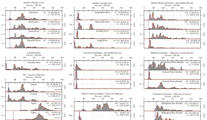
Figure 4 displays detrital zircon age distributions for each of the samples processed over the 0-300 Myr interval; complete age distributions over the 0-3000 Myr interval are displayed in Supplementary Figure 1. Few samples yield zircons older than Mesozoic in age; these older zircons are present in
small proportions (commonly < 20%) and display the same
age populations: 1.05-1.2 Ga, 1.3-1.4 Ga, 1.5-1.8 Ga, 1.9-2.1 Ga, 2.3-2.4 Ga, and 2.5-2.8 Ga. Older populations are
significant (>5%) in the sands of the Elwha and Columbia
rivers and in samples of the OSC (sample #27), the Chuckanut Formation (samples #22 and 23), and the Blakely Harbor Formation (Samples #15-18). Maximum depositional ages are displayed in Table 1.
4.1. Modern Rivers. Samples #1-4 from Cascade rivers are rich in quartz and volcanic lithic fragments, plotting in the “recycled orogen” domain on the QFL plot. Age distributions from modern Cascade rivers contain >97% zircons younger than 250 Ma, with >90% of the zircons younger than 110 Ma. Two main age populations can be distinguished, with their contribution varying between samples: 15-40 Ma and 85-100 Ma. Samples #3 (Puyallup River, draining Mount Rainier) and #4 (Skagit River, draining two active volcanoes, Mount Baker and Glacier Peak) yield recent (<5 Ma) zircons. Samples #5-8 from Olympic rivers are rich in quartz and
sedimentary lithic fragments, plotting in the“recycled
oro-gen” domain on the QFL plot. Age distributions from mod-ern Olympic rivers contain >85% zircons younger than 250 Ma, but the contribution of older Cretaceous and Jurassic ages (110-250 Ma) is higher (~23% of zircons), with two prominent age populations at 140-170 Ma (all samples) and 180-220 Ma (Hoh and Elwha rivers). All Olympic rivers dis-play the 85-100 Ma age peak found in modern Cascade rivers; samples #5 and #7, from the Elwha and Queets rivers, display a well-defined population centered at 50 Ma. The 15-40 Ma population found in Cascade river sands is barely expressed in Olympic rivers (<4% of zircons). The youngest grains for all Olympic rivers span from 20 to 24 Ma (Table 1).
Sample #9 from the Columbia River is rich in quartz and
volcanic lithic fragments, plotting in the“recycled orogen”
domain on the QFL plot. Sample #9 yields ages spanning the last 180 Ma, with few (~5% of zircons) pre-Mesozoic ages, despite its wide drainage basin covering Precambrian strata near its sources. Two age populations are particularly well marked: 45-55 Ma and <5 Ma.
4.2. OSC. Samples #26 and 27 of the Miocene coastal OSC display petrographic assemblages similar to modern Olympic rivers, dominated by quartz and lithic fragments, plotting in
the“recycled orogen” field. The two samples also display age
distributions similar to those of samples from modern Olym-pic rivers. They contain a major population at 85-100 Ma and subordinate populations at 45-55 Ma and 140-170 Ma.
Sam-ples #26 and #27 both display a significant population of
early Miocene ages with maximum depositional ages at 16.5 and 16:7 ± 0:5 Ma (2 s; Table 1).
Samples #24 and 25 from the upper OSC (late Eocene to Oligocene/early Miocene) display the same petrographic results as coastal OSC samples, but significantly different age distributions. Both age distributions are dominated by one single 170-230 Ma peak, with only few younger and older grains. The characteristic 0-110 Ma age range of the modern Cascade rivers is notably absent, with most of the zircons
sig-nificantly older than the depositional ages of the samples.
4.3. Puget Lowland. Samples #22 and 23 from the Chuckanut Formation are distinct from other samples as they are partic-ularly rich in quartz and metamorphic lithic fragments, with
sample #22 plotting in the“continental block domain” on the
QFL plot (Figure 5). Their age distributions are rich in pre-Mesozoic grains (30 to 40% of zircons); younger grains cover
the 55-200 Ma range, with a significant Late
Samples #10 and 11 from the Bulson Creek assemblage
are notably different from each other. Sample #10 is rich in
quartz, metamorphic and sedimentary lithic clasts; it displays one population of younger grains clustered at 50 Ma, with most ages ranging between 115 and 280 Ma (>90% of
zircons). Sample #11 consists entirely of volcaniclastic lithic grains and rare quartz grains; its age distribution shows a sin-gle prominent population between 28 and 35 Ma, with rare
older accessory grains. Sample #11 yields a 29:0 ± 0:8 Ma
maximum depositional age (2 s; Table 1).
0 5050 100 150 200 250 300 Zircons < 300 Ma 0 5050 100 150 200 250 300 Zircons < 300 Ma 0 5050 100 150 200 250 300 Zircons < 300 Ma 0 50 100 150 200 250 300 Zircons < 300 Ma
Chuckanut Formation - Paleocene to Eocene Bulson Creek assemblage - Eocene to Oligocene
Modern Cascade rivers
Vasa Park assemblage - late middle Miocene
0 5050 100 150 200 250 300 Zircons < 300 Ma 0 5050 100 150 200 250 300 Zircons < 300 Ma 0 5050 100 150 200 250 300 Zircons < 300 Ma OSC - Eocene to Miocene
Modern Olympic rivers
Columbia River #8 18-HOHR-01 n = 154 of 164 Hoh River 16 0.02 #5 18-ELWR-01 n = 112 of 145 Elwha River 11 0.02 #7 19-QUER-01 n = 135 of 167 Queets River 13 0.02 #6 19-BOGR-01 n = 164 of 177 Bogachiel River 14 0.02 #9 18-COLR-01 n = 136 of 167 Columbia River 14 0.02 #26 18-HOH-01 n = 174 of 178 Coastal 18 0.02 #27 18-HOH-02 n = 140 of 157 Coastal 14 0.02 #24 19-OSC-01 n = 169 of 172 Upper 14 0.02 #25 19-OSC-02 n = 149 of 157 Upper 15 0.02 #1 19-SNOR-01 n = 161 of 162 Snoqualmie River 120 0.15 #2 18-CASCR-01 n = 162 of 165 Skykomish River 60 0.075 #3 18-CASCR-02 n = 146 of 158 Puyallup River 105 0.15 #4 18-CASCR-03 n = 173 of 173 Skagit River 60 0.075 #13 18-VAP-01 n = 164 of 168 50 0.05 #14 18-VAP-03 n = 166 of 166 100 0.1 305 0.0375 #12 18-RNT-02 n = 163 of 163 #10 18-BLC-01 n = 159 of 160 8 0.01 #11 18-BLC-02 n = 108 of 109 408 0.075 #22 18-CHK-01 n = 98 of 161 Bellingham Bay Member
10
0.02
#23 18-CHK-02 n = 107 of 158 Bellingham Bay Member
14
0.025
0 5050 100 150 200 250 300
Zircons < 300 Ma Blakely Harbor Formation - late middle Miocene
#15 17-BLH-01 n = 108 of 130 11 0.02 #16 18-BLH-01 n = 112 of 156 11 0.02 #17 18-BLH-02 n = 104 of 161 10 0.02 #18 18-BLK-02 n = 137 of 150 34 0.05 0 5050 100 150 200 250 300 Zircons < 300 Ma #20 19-BLK-01 n = 107 of 108 Orchard Point Member
50 0.1
#21 19-BLK-02 n = 143 of 160 Orchard Point Member
10
0.02
#19 18-BLK-01 n = 71 of 99 Restoration Point Member
4
0.01
Blakeley Formation - Oligocene to early Miocene
Figure 4: Histograms and kernel density estimate diagrams for detrital zircon age distributions of all samples, showing only zircon ages < 300 Ma (for full age distributions see Supplementary Figure 1). River samples are grouped by drainage region, and rock samples are grouped by formation. All ages are displayed in 5 Myr bins. Histogram counts are labeled on the left axis. Probability is labeled on the right axis. Blue line = maximum depositional age.
Q L F Lm Ls Lv Magmatic arc Suture belt Undissected arc Continental block Dissected arc Transitional arc Recycled orogen Blakeley Fm. Bulson Creek assem. Chuckanut Fm. Coastal OSC Upper OSC Modern Cascade rivers
Modern Olympic rivers Vasa Park assem. Blakely Harbor Fm. Columbia River
Figure 5: Ternary diagrams of sediment modal composition for modern rivers and rock samples from the Puget Lowland and the Olympic Peninsula according to the Gazzi-Dickinson method [59, 95].
Samples of the Blakeley Formation can be divided into two groups. Samples #19 and #21 are rich in quartz and
vol-canic lithic fragments, and plot in the “recycled orogen”
domain; most zircons are in the 20-110 Ma age range with an important Cretaceous population, and a secondary population around 50 Ma for sample #19. Sample #20 is rich in volcanic lithic grains, with rare quartz grains; its age distri-bution show a characteristic zircon population between 20
and 35 Ma, with a 26:1 ± 0:7 Ma maximum depositional age
(2 s; Table 1).
Samples #15-17 of the late middle Miocene Blakely Harbor Formation display similar age distributions to one another, and mirror age distributions of modern Olympic rivers; ages cover the full 20-230 Ma range with a major pop-ulation around 85-100 Ma and a subordinate poppop-ulation at 45-55 Ma. Sample #18 spans a similar age range, though it has a primary age peak at ~30 Ma and contains only rare accessory grains between ~120 and 230 Ma. In contrast to the Olympic river sands, samples #15-17 are mostly made of basaltic lithic clasts, a feature recognized by Fulmer [39]. Maximum depositional ages are all similar to those of the Blakeley Formation samples (22-30 Ma; Table 1) and much older than the depositional age of the Blakely Harbor Forma-tion (13:3 ± 1:3 Ma; [40]).
Samples #12-14 of the Vasa Park assemblage show dis-tinctive characteristics in their petrography and age distribu-tions. All three samples contain primarily quartz grains and lithic clasts with roughly the same amount of volcanic and sedimentary lithic fragments. Samples #12 and #14 show a single, late middle Miocene population and maximum
depo-sitional ages at 12:3 ± 0:3 and 11:1 ± 0:3 Ma (Table 1); this
second age is statistically similar to the 11:4 ± 0:6 Ma
40Ar/39Ar age that is reported at the same locality [56, 58].
Sample #13 shows a similar maximum depositional age at
11:8 ± 0:3 Ma, but with an age range spanning 10-50 Ma
(Table 1; Figure 4).
5. Interpretation
5.1. Provenance of Modern Cascade River Sands. The age dis-tributions of samples #1-4 from modern Cascade river sands are a combination of young zircon populations derived from the Cascade Arc (ages < 45 Ma) and minor, older populations derived from the Coast Mountains Batholith (clusters at 65-75 Ma, 85-105 Ma, 140-165 Ma, and 200-210 Ma; Figure 6). Below, we use these age distributions as a signature for zir-cons derived from the Cascades; sedimentary rocks that were sourced from the Cascades should contain similar zircon populations and are expected to incorporate young volcanic zircons from the Cascade Arc that are coeval or only slightly delayed in age with the deposition of the unit.
5.2. Provenance of the OSC. Our study highlights two distinct provenances for the OSC. Samples #24 and 25 of the upper OSC (early Eocene to early Miocene in age) are dominated by a single Late Triassic to Early Jurassic population (170-220 Ma) that is absent in every other sample, including modern Cascade rivers (Figure 4). There are Late Triassic-Early Jurassic plutons in the crystalline core of the Cascades
[67, 68], but they barely contribute to the zircon load of mod-ern Cascade rivers, as highlighted here. Thermochronologi-cal data show that the crystalline core of the Cascades remained mostly unexhumed until the Miocene: rocks from
the westflank of the Cascades yield apatite-He cooling ages
between 12 and 6 Ma; rocks from the east flank show a
broader range of apatite-He cooling ages between 60 and 18 Ma, though they also display far slower exhumation rates throughout the Cenozoic [69]. Mesozoic strata from the Methow Valley, east of the Cascades, contain abundant Late Jurassic and Early Cretaceous zircon populations, but zircons older than 200 Ma are either entirely absent, as seen in the Boston Bar and Twisp Formations [70], or they are extremely rare (>2%), as in the Winthrop, Harts Pass, and Midnight Peak Formations and the Jackass Mountain Group [71].
Another potential source for the 170-220 Ma age peak found in samples #24 and 25 is the Bonanza Arc of the Wrangellia Terrane, which is exposed on Southern and Western Vancouver Island [72]. Rocks of the Bonanza Arc yield U-Pb ages ranging from 168 to 202 Ma; associated vol-caniclastic strata indicate that magmatic activity had started earlier in the Triassic, potentially as early as 230 Ma [73]. A similar 170-220 Ma zircon population is found in the age distribution of samples from Cretaceous forearc strata in the Georgia Basin, east of Vancouver Island [74]. This popu-lation is particularly prominent in samples from the Comox Formation of the lower Nanaimo Group in the southern part of the Georgia Basin, and is interpreted by Huang et al. [74]
as reflecting sediment sourced from the Bonanza Arc
(Figure 7). Other age populations found in samples of the Comox Formation include age clusters at 344-364 Ma and 450-455 Ma, and ages younger than 170 Ma; these popula-tions are interpreted as reflecting sediment drained from the Coast Mountains and the metamorphic and igneous basement of Vancouver Island [74]. However, these ages are absent from our samples of the upper OSC. Rocks of the Bonanza Arc crop out on extensively along the southern and western slope of Vancouver Island; this makes it possible
for sediment from the Bonanza Arc to drain into the Pacific
Ocean without incorporating zircons from other basement rocks, from forearc strata, or from the Coast Mountains [75]. We interpret the 170-220 Ma age population in our samples of the upper OSC as also reflecting sediment drained form the Bonanza Arc on Vancouver Island. Major exhuma-tion of the Wrangellia Terrane is recorded between 50 and 40 Ma, which is contemporary with deposition of the upper OSC and shows that the Bonanza Arc is a viable source of sediment to the upper OSC [76]. We suggest that our samples originated as turbiditic events generated along the Vancouver Island slope during this period of exhumation.
The Late Triassic-Early Jurassic population identified in
upper OSC samples is barely expressed in samples of the coastal OSC and modern Olympic rivers. The composite age distribution of the (Miocene) samples from the coastal OSC contains the same zircon populations that are found in the composite age distribution of modern Cascade rivers, aside from the complete absence of middle Miocene and younger zircons in the coastal OSC (Figure 6). These features indicate that the coastal OSC was likely derived from Cascade
material. The composite age distribution of modern Olympic rivers is also similar to the composite output of Cascade
riv-ers (Figure 6), with some differences. Olympic rivers contain
a relatively low proportion of 0-50 Ma grains (~6.5% of zircons) and display a 110-200 Ma population, which is
underrepresented in modern Cascade rivers. The four modern Olympic rivers we sampled all drain the core of the Olympic Peninsula, which is dominated by the oldest (Eocene) OSC rocks; this drainage is consistent with an underrepresentation of 0-50 Ma grains and a higher
25 50 0.05 0.05 0.02 0 60 120 180 240 300 Cascade Volcanism: 45-0 Ma Deposition of Blakeley fm. : 30-22 Ma Deposition of Blakely Harbor and Vasa Park: 13.3-11 Ma Zircons < 300 Ma H ist ogra m C o un ts Prob abi lit y
Deposition into Swauk Basin: 60-51 Ma 0.02 20 0.1 0.002 0.02 0.02 0.02 50 200 25 25 50 50 Blakeley fm.
Bulson Creek assemblage
Chuckanut fm. Modern Cascade rivers
Coastal OSC
Upper OSC
Vasa Park assemblage Modern Olympic rivers
Blakely Harbor fm. Columbia river N = 4 n = 642 of 658 N = 2 n = 314 of 335 N = 2 n = 318 of 329 N = 3 n = 493 of 497 N = 4 n = 565 of 653 N = 4 n = 461 of 597 N = 1 n = 136 of 167 20 0.02 Bonanza Arc: ~168-230 Ma N = 3 n = 321 of 367 N = 2 n = 267 of 269 N = 2 n = 205 of 319
Figure 6: Histograms and kernel density estimate diagrams for sample groups showing only zircon ages < 300 Ma. Samples are grouped by unit/drainage region. Colored bars indicate important depositional ages and age peaks particular to individual source regions. All histograms are in 5 Myr bins.
representation of older populations. We suggest that despite
these differences, the majority of the sedimentary rocks in
the core of the Olympic Peninsula were sourced by drainage of the Cascades.
The presence of zircons as young as 20 Ma in Olympic rivers draining the core of the peninsula indicates that the Olympics remained topographically low prior to the early
Miocene. The maximum depositional ages of 16.5 and 16:7
± 0:5 Ma in samples #26 and #27 of the coastal OSC indicate
that the OSC was fed by Cascade-derived sediment until at least that time.
5.3. Provenance of the Puget Lowland. Samples #22 and 23 of
the Chuckanut Formation display a significant population of
pre-Mesozoic grains and, in addition to the well-marked 90 Ma population found in all forearc samples, a distinct
75 Ma population, which is not well expressed in the modern Cascade rivers. The age distributions of these samples are remarkably similar to those of Maastrichtian strata of the upper Nanaimo Group in the Georgia Basin, which also display two Cretaceous age peaks centered at 75 and 90 Ma, and older age populations centered at 1380 Ma and 1650-1800 Ma (Figure 7; [77, 78]). The age clusters at 90 Ma, 1380 Ma, and 1650-1800 Ma found in upper Nanaimo sam-ples have been interpreted as derived from Idaho [79] and the younger ages from the Coast Mountains Batholith. Alter-natively, Mathews et al. [63] showed that these ages are also found in the Mojave-Sonoran Region (MSR) of the Southwestern United States, advocating for a much lower paleolatitude for Vancouver Island at the time of deposition of the Nanaimo Group followed by a large coastwise transla-tion of the Wrangellia Terrane during the Cretaceous [80].
Bonanza Arc: ~168-230 Ma Idaho signature (Dumitru et al., 2016)
Zircon ages (Ma)
0 100 200 300 1000 2000 3000 Chuckanut Fm. N= 2 n = 319 Upper OSC N = 2 n = 329 Maastrichtian Nanaimo N = 6 n = 1713 Comox Fm. N = 3 n = 900 Probability 0.025 0.025 0.025 0.025 300 0.001 0.0001 0.0001 0.0001 40 38 150 25 180 7 35 6 Histogram counts
Figure 7: Histograms and kernel density estimate diagrams for the upper OSC, Chuckanut Formation, Comox Formation (samples S19, S20, and S21 from [74]), and Maastrichtian strata of the Nanaimo Group (samples GF1, GF2, GF3, SP, GB3, and GB4 from [78]). Age distributions for each sample are split into ages < 300 Ma with 5 Myr histogram bins, and ages 300-3000 Ma with 20 Myr histogram bins.
The paleolatitude of the Wrangellia Terrane and the distinc-tion between the two possible sediment source regions for the Nanaimo Group are both topics of ongoing debate. The age distributions of our samples suggest that either the Chuckanut Formation and the Maastrichtian strata of the Nanaimo Group share the same sediment source, or that the Chuckanut Formation was sourced from reworking of the Nanaimo Group. A direct provenance from the MSR is unlikely for the Chuckanut Formation as the proposed coast-wise translation of accreted terranes would have been achieved several millions of years prior to deposition of the Chuckanut Formation in the early Eocene [80]. At present, our prove-nance data do not allow us to distinguish between a sediment source for the Chuckanut Formation either in northern Idaho or from reworking of the Nanaimo group. A potential rework-ing of the Nanaimo group at that time requires further validation as thermochronological data do not show major exhumation of the Nanaimo Group until 50 Ma [76].
The source of the Bulson Creek assemblage is also prob-lematic. The volcaniclastic nature and age distribution of sample #11 indicates a direct sourcing from the Cascade Arc. By contrast, sample #10 displays a dominant, broad age population ranging between 115 and 280 Ma, which is barely expressed in any other sample. This broad population overlaps with the ages of magmatism found in the Eastern Magmatic Belt of the Coast Mountains Batholith in British Columbia, though it is unclear how sediment derived from this region could have been transported far enough south-west to become incorporated into the Bulson Creek assem-blage [81]. The Western mélange melt (WMB) crops out in close vicinity to our sampling site; age distributions of sam-ples from the WMB are heterogeneous, with some samsam-ples displaying a well-marked 100-200 Ma age population while others do not [82–84]. It is possible that sample #10 is locally derived from the reworking of WMB material.
Samples #19 and 21 of the Oligocene to early Miocene Blakeley Formation are volcaniclastic or quartz-rich, and the composite age distribution of the Blakeley Formation shows prominent age peaks at 30 Ma and 90 Ma, and a small population at 140-160 Ma (Figures 5 and 6). The same peaks are found in the same proportions in the composite age dis-tribution of modern Cascade rivers (Figure 6). The prove-nance and petrography data of the Blakeley Formation are consistent with drainage of the Cascades as the sediment source.
Both the Vasa Park assemblage and the Blakely Harbor
Formation are fluvial, lithic sedimentary units that were
deposited into the Cascadia Forearc in the late middle Miocene, with the Vasa Park assemblage deposited in the east of the forearc basin and the Blakely Harbor Formation deposited further west (Figures 1 and 3). Samples #12-14 of the Vasa Park assemblage are entirely volcaniclastic and likely have a source in the Cascade Arc. By contrast, samples #15-18 of the Blakely Harbor Formation show significant (7-22 million years) offset between their maximum depositional ages and their true depositional ages (Figure 8). This offset indicates that the Cascade arc did not supply sediment to the Blakely Harbor Formation. The maximum depositional ages of samples #15-18 (22-30 Ma; Table 1) are the same as
those of samples #19-21 of the Blakeley Formation (22.8-30 Ma; Table 1). The composite age distribution of the Blakely Harbor Formation very closely resembles the com-posite distributions of the modern Olympic rivers and the Blakeley Formation, with the exception of a prominent age peak at 50 Ma that is only well expressed in the Blakely Harbor Formation and the Columbia River (Figure 6). This 50 Ma peak is consistent with the age of the Crescent Forma-tion, and the Blakely Harbor Formation contains abundant basaltic lithic clasts, which have been attributed to the incor-poration of felsic and basaltic material from the Crescent Formation [39, 54]. These provenance and petrographic data show that the Blakely Harbor Formation was sourced by sed-iment that was eroded from the Crescent Formation and from older sedimentary units including the Blakeley Forma-tion. There are two potential source areas where the Crescent Formation, the Blakeley Formation, and associated units of the Puget Group are exposed in close vicinity:
(1) The easternflank of the Olympic Peninsula,
approx-imately 30 km away from our sample location, where these units are exposed over thousands of square kilometers
(2) The hanging wall of the SFZ in the Green Mountain area, approximately 20 km away from our sample location, where exposure is much more limited (<100 km2; [15, 53])
Everywhere else in the Puget Lowland, the hanging wall of the SFZ is covered by Puget Group sediment and does not expose the Crescent Formation [50, 51, 85–87]
Our petrographic and detrital zircon data are insufficient to distinguish between these two source areas as they display the same geological units. However, we suggest that a single contribution from the SFZ hanging wall is unlikely. Both the Blakely Harbor Formation and the Vasa Park assemblage are in the footwall of the SFZ [51, 86]; our samples of the Vasa Park assemblage do not show evidence for reworking of Puget Group material, which is immediately adjacent in the SFZ hanging wall.
The only thermochronological data available for the SFZ
is an apatitefission-track age from the Green Mountain area
dated at 32 ± 5 Ma [53]. This age dates the onset of exhuma-tion of the SFZ hanging wall 10 to 25 Myr earlier than depo-sition of the Blakely Harbor Formation. Assuming a
geothermal gradient of 20°C/km in the forearc [88, 89] and
a functional closure temperature of 120°C for the apatite
fission-track system [90], this fission-track age limits average exhumation to ~0.2 km/Myr since the Oligocene. Exhuma-tion was to 4-10 times higher in the Olympic Peninsula dur-ing the late middle Miocene, with rates estimated between 0.75 and 2 km/Myr [7, 9]. The Olympic Peninsula is a more likely source as it was actively denuded during the period of deposition of the Blakely Harbor Formation. Though further
thermochronological work on the SFZ is needed to confirm
this interpretation, the plausible presence of material derived from the Olympic Peninsula in the Blakely Harbor Forma-tion suggests that the peninsula had already been subaerially exposed and sufficiently uplifted to form a local topographic
high and supply sediment to eastward draining rivers. The tuff dated at 13:3 ± 1:3 Ma at the base of the unit [40] gives a minimum age for the emergence of the Olympic Peninsula (Figure 9).
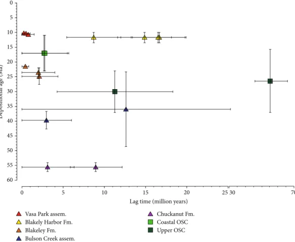
All the samples interpreted here asflowing directly from
the Cascades display a short lag time between their deposi-tional age and the age of their youngest zircon population, commonly <5 Myr (Figure 8). Samples interpreted as coming from Vancouver Island (upper OSC) or mostly made from the reworking of older material (Chuckanut Formation, Bulson Creek assemblage, and Blakely Harbor Formation) display much longer lag times (9 to 60 Myr), which corrobo-rates their provenance from areas without coeval volcanism.
6. Discussion
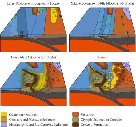
Our data confirm that the upper OSC has a different origin from other structural units of the Olympic Peninsula, which has important implications for the build-up of the Cascadia accretionary wedge. Age distributions and sedimentary grain petrography of the Miocene coastal OSC and modern Olym-pic rivers indicate that they are derived from the Cascades; this is consistent with deposition and incorporation in a typ-ical accretionary wedge, with Cascade material transported through the forearc and into the subduction trench [27]. By contrast, our samples of the Eocene upper OSC are derived from Vancouver Island and do not include Cascade-derived zircons; this suggests that parts of the upper OSC were
depos-ited offshore at a significant distance from the Cascadia trench. These data support the interpretation of Brandon et al. [7] who proposed that the upper OSC was deposited as the western continuation of the Siletzia terrane, and was later imbricated and underthrust beneath the eastern strata of Siletzia following the initiation of the Cascadia subduction zone (Figure 9: middle Eocene to middle Miocene). Despite the Cretaceous and middle Eocene maximum depositional ages of our two samples (Table 1), the upper OSC has yielded biostratigraphic ages as young as the lower Miocene, and our two samples are mapped as post-middle Eocene [25, 26]. It is very likely that our samples represent older strata of the upper OSC that have been reprised into a mélange and are part of broken formations, integrating younger foraminifera, as seen in many places in the upper OSC [7, 15].
There is quasicontinuous volcanism within the Cascade
Arc since 45 Ma, despite periods of lower flux and varying
composition [14]; it is expected that we would observe the presence of continually younger zircons within the OSC until uplift of the Olympic Peninsula precluded Cascade material from entering the accretionary wedge. As such, the presence of the youngest zircon population within the coastal OSC at
16:5 ± 0:5 Ma provides the maximum age at which the
Peninsula was not uplifted and had not yet formed a topo-graphic barrier. There are two mechanisms that could bring zircons of postuplift age into the Olympic accretionary wedge. First, younger zircons brought to the sea by the Columbia River, or an older analogue, south of the peninsula Vasa Park assem.
Blakely Harbor Fm. Blakeley Fm. Bulson Creek assem.
Chuckanut Fm. Coastal OSC Upper OSC 60 55 50 45 40 35 30 25 20 15 10 5 0
Lag time (million years)
D ep osi tio n al ag e (M a) 0 5 10 15 20 2530 70
could have been transported 150 km northward along the Olympic Coast by longshore drift to eventually arrive at the trench in front of the OSC, at the northernmost end of the modern deep-sea Astoria Fan. Today, Columbia River sedi-ment is transported up to 100 km northwards into the Quinault Canyon along the southern part of the Olympic Coast [91]; this has also been observed for Mount Saint Helens ash material [92]. However, most of the modern
sed-iment reaching the Quinault Canyon is very fine grained
(silty clay; [93]), well below the grain size of the zircons we analyzed (25-micron minimum laser beam diameter). An alternative way that postuplift zircons could have been trans-ported into the Cascadia trench and subsequently into the accretionary wedge is conveyance via a proto-Strait of Juan de Fuca around the north of the peninsula followed by a 100 km southward transit either by longshore drift or, less likely, deeper trench-parallel turbidity currents. Today, there is almost no southward longshore drift along the Washington coast due to the dominance of southwesterly winds in the winter [92]. Additionally, the age distribution of the coastal OSC is not consistent with either sediment sup-ply from the Columbia River or from Vancouver Island, so it is unlikely that these mechanisms supplied fresh zircons to the OSC after uplift of the Olympic Peninsula cut off drain-age from the Cascade Arc (Figure 9).
The late middle Miocene Blakely Harbor Formation in the Washington forearc displays age distributions and grain petrography that are consistent with a direct supply from the Olympic Peninsula. Our data cannot exclude that this
formation was sourced by material from the hanging wall of the Seattle Fault, as proposed by ten Brink et al. [51], but we suggest that this source is less likely due to the low exhu-mation rates of the SFZ at that time and the absence of hang-ing wall reworkhang-ing in the Vasa Park assemblage. While thrust loading along the SFZ likely contributed to the subsidence of the Seattle Basin and the deposition of the Blakely Harbor Formation in the late middle Miocene [50, 51], a contribu-tion of the SFZ hanging wall to the sedimentary supply remains to be shown. We show that the Olympic Peninsula very likely contributed sediment to the Blakely Harbor For-mation, making the age of the base of the Blakely Harbor Formation a maximum constraint on the emergence of the peninsula and formation of a topographic high.
Our sedimentary provenance data bracket the timing of the emergence of the Olympic Peninsula to a narrow window
in the late middle Miocene, after 16:5 ± 0:5 Ma and likely
before 13:3 ± 1:3 Ma (2 s), though this latter age remains to
be confirmed by a more thorough study of the exhumation
of the SFZ. Brandon et al. [7] estimated that sediment accreted to the base of the accretionary wedge would take
~4.4 Myr to rise from the depth of accretion to the
α-dam-aged zircon closure depth of 10 km, assuming a constant exhumation rate of 0.75 km/Myr as observed for the last 14 Ma, and they show that this 10 km depth was reached ca. 13.7 Ma. These estimates date the onset of exhumation to ca. 18.1 Ma, at least two million years before our proposed window for the emergence of the peninsula. Michel et al. [9] proposed a faster rate (2 km/Myr) for the initial phase
Quaternary Sediment
Cenozoic and Mesozoic Sediment Olympic Subduction Complex Crescent Formation Volcanics Metamorphic and Pre-Cenozoic Sediments
Middle Eocene to middle Miocene (40-16 Ma)
Late middle Miocene (ca. 13 Ma) Present Latest Paleocene through early Eocene
GB SB
ST
Figure 9: Synthesis of generalized block diagrams showing changes in geology and proposed sediment drainage patterns in Western Washington State during the Cenozoic. ST = Siletzia terrane; GB = Georgia Basin; SB = Swauk Basin.
of exhumation, decreasing to bellow modern rates at 5-7 Ma. Using this faster initial exhumation rate, and the same model as Brandon et al. [7], we estimate exhumation to begin at ca. 15.3 Ma, which falls within our proposed time window for the emergence of the Olympic Peninsula. These estimates are based on a simple model for the trajectory and tempera-ture history of material accreted to the wedge and should be assessed with caution. In the framework of this simple model, and assuming that there was little preemergence erosion and exhumation in the accretionary wedge, our timing for the emergence of the peninsula is in agreement with models arguing for an early phase of high exhumation [9] and a com-posite deformation history for the accretionary wedge.
Our work constrains the initial subaerial exposure of the Olympic Peninsula and the formation of a topographic barrier to the late middle Miocene, but we do not exclude the possibility of earlier deformation and uplift of the accre-tionary wedge. Deformation predating the emergence of the peninsula may have occurred in the Oligocene to early Miocene, and this deformation may be recorded in the strata of the Blakeley Formation. The Blakeley Formation is domi-nated by submarine fan deposits, some of which have yielded foraminifera found at bathyal to abyssal depths (deeper than 1 km; [39]). The presence of such depths in a forearc basin requires a mechanism to create high subsidence. Johnson et al. [50] linked this subsidence to an early phase of thrusting along the SFZ, the timing of which is supported by apatite fission-track data [53]. More thermochronological work
along the SFZ is needed to confirm this early phase of
defor-mation; if confirmed, this Oligocene episode of thrusting on
the SFZ provides evidence for margin-parallel shortening and initiation of the Olympic orocline that predates emer-gence of the Olympic Peninsula by at least ten million years.
7. Conclusion
Our combined detrital zircon provenance and grain petrog-raphy data from the Olympic Peninsula and the Puget Low-land allow us to reconstruct the Cenozoic history of the
Cascadia subduction zone. Wefirst show a distinct
sedimen-tary provenance of the upper OSC that differs from other structural units of the Olympic Peninsula. Upper OSC sam-ples comprise only material from Vancouver Island and show no mixing with young (post-40 Ma) zircons. These results indicate that the upper OSC was deposited as part of the Siletzia terrane before its accretion to the Cascadia mar-gin, and was later imbricated and underthrust beneath the Crescent Formation. Other units of the OSC represent accreted Cascadia trench sediment and show input from
the Cascades into the accretionary wedge until at least 16:5
± 0:5 Ma, providing an older age limit for the emergence of
the Olympic Peninsula. Thefluvial deposits of the late middle
Miocene Blakely Harbor Formation record thefirst input of
recycled Crescent Formation and OSC/forearc material into the Seattle Basin. Though we cannot exclude some contribu-tion from the hanging wall of the Seattle Fault Zone, we sug-gest that the Blakely Harbor Formation provides a minimum age for input of eroded material from the Olympic Peninsula into the Puget Lowland; this gives a younger age limit of
13:3 ± 1:3 Ma for the emergence of the peninsula. We finally
propose that the initial onset of deformation and oroclinal bending in the Olympic Peninsula predates emergence by
at least 10 Myr, marked byflexural subsidence along the
Seat-tle Fault Zone and the deposition of the Blakeley Formation in the Oligocene.
Data Availability
All data used in support of our conclusions are made available in the body of this paper and in the supplementary materials provided with it.
Conflicts of Interest
The authors declare that there is no conflict of interest regarding the publication of this article.
Acknowledgments
This research was primarily funded by the University of Washington. Samples in the Olympic National Park were collected under the permit OLYM-2018-SCI-0036. We thank Susie Winkowski from Vasa Park Resort to have allowed us access to their property. We also thank M. Mueller, Tamas Ugrai, Ralph Haugerud, Hope Sisley, Eric Cheney, Alexandre Delga, Matthew Dubeau, the Olympic National Park Service, and Darrel Cowan for prolific discussions and assistance in
the field and in the lab. We also thank Ralph Haugerud,
William Matthews, Sarah Roeske, and Stephen Johnston for their insightful and constructive reviews of this manuscript.
Supplementary Materials
Supplementary File 1: complete analytical procedure for detrital zircon provenance analysis. Supplementary Table 1: grain-counting data. Supplementary Table 2: U-Pb data. Supplementary Figure 1: histograms and kernel density estimate diagrams for detrital zircon age distributions of all samples. River samples are grouped by drainage region, and rock samples are grouped by formation. All ages are displayed in 20 Myr bins. (Supplementary Materials)
References
[1] M. T. Brandon and A. R. Calderwood,“High-pressure
meta-morphism and uplift of the Olympic subduction complex,”
Geology, vol. 18, no. 12, pp. 1252–1255, 1990.
[2] R. W. Tabor and W. M. Cady,“The structure of the
Olym-pic Mountains, Washington: analysis of a subduction zone
(Vol. 1033),” US Govt. Print. Off. USGS Professional Paper
1033, p. 38, 1978.
[3] W. Glassley,“Geochemistry and tectonics of the Crescent
vol-canic rocks, Olympic Peninsula, Washington,” Geological
Soci-ety of America Bulletin, vol. 85, no. 5, pp. 785–794, 1974.
[4] R. Wells, D. Bukry, R. Friedman et al.,“Geologic history of
Siletzia, a large igneous province in the Oregon and Washing-ton Coast Range: correlation to the geomagnetic polarity time
scale and implications for a long-lived Yellowstone hotspot,”
![Figure 1: Regional geologic map of the Olympic Peninsula, Puget Lowland, and the eastern extent of the North Cascades (modi fi ed from [7, 94]).](https://thumb-eu.123doks.com/thumbv2/123doknet/13719486.435269/4.899.180.717.104.1008/figure-regional-geologic-olympic-peninsula-lowland-eastern-cascades.webp)

![Figure 7: Histograms and kernel density estimate diagrams for the upper OSC, Chuckanut Formation, Comox Formation (samples S19, S20, and S21 from [74]), and Maastrichtian strata of the Nanaimo Group (samples GF1, GF2, GF3, SP, GB3, and GB4 from [78])](https://thumb-eu.123doks.com/thumbv2/123doknet/13719486.435269/13.899.92.810.113.760/histograms-estimate-diagrams-chuckanut-formation-formation-maastrichtian-nanaimo.webp)