HAL Id: hal-00297057
https://hal.archives-ouvertes.fr/hal-00297057
Submitted on 2 Jan 2008
HAL is a multi-disciplinary open access
archive for the deposit and dissemination of
sci-entific research documents, whether they are
pub-lished or not. The documents may come from
teaching and research institutions in France or
abroad, or from public or private research centers.
L’archive ouverte pluridisciplinaire HAL, est
destinée au dépôt et à la diffusion de documents
scientifiques de niveau recherche, publiés ou non,
émanant des établissements d’enseignement et de
recherche français ou étrangers, des laboratoires
publics ou privés.
Shallow shear-wave reflection seismics in the tsunami
struck Krueng Aceh River Basin, Sumatra
U. Polom, I. Arsyad, H.-J. Kümpel
To cite this version:
U. Polom, I. Arsyad, H.-J. Kümpel. Shallow shear-wave reflection seismics in the tsunami struck
Krueng Aceh River Basin, Sumatra. Advances in Geosciences, European Geosciences Union, 2008, 14,
pp.135-140. �hal-00297057�
Adv. Geosci., 14, 135–140, 2008 www.adv-geosci.net/14/135/2008/ © Author(s) 2008. This work is licensed under a Creative Commons License.
Advances in
Geosciences
Shallow shear-wave reflection seismics in the tsunami struck Krueng
Aceh River Basin, Sumatra
U. Polom1, I. Arsyad2, and H.-J. K ¨umpel1
1Leibniz Institute for Applied Geosciences, PO Box 510153, Stilleweg 2, 30655 Hannover, Germany 2Dinas Pertambangan dan Energi, Jalan T. Nyak Arief No. 195, 23114 Banda Aceh, Indonesia
Received: 18 June 2007 – Revised: 5 November 2007 – Accepted: 10 November 2007 – Published: 2 January 2008
Abstract. As part of the project “Management of Georisk”
(MANGEONAD) of the Federal Institute for Geosciences and Natural Resources (BGR), Hanover, high resolution shallow shear-wave reflection seismics was applied in the In-donesian province Nanggroe Aceh Darussalam, North Suma-tra in cooperation with the Government of Indonesia, lo-cal counterparts, and the Leibniz Institute for Applied Geo-sciences, Hanover. The investigations were expected to support classification of earthquake site effects for the re-construction of buildings and infrastructure as well as for groundwater exploration. The study focussed on the city of Banda Aceh and the surroundings of Aceh Besar. The shear-wave seismic surveys were done parallel to standard geoengineering investigations like cone penetrometer tests to support subsequent site specific statistical calibration. They were also partly supplemented by shallow p-wave seismics for the identification of (a) elastic subsurface parameters and (b) zones with abundance of groundwater. Evaluation of seismic site effects based on shallow reflection seismics has in fact been found to be a highly useful method in Aceh province. In particular, use of a vibratory seismic source was essential for successful application of shear-wave seismics in the city of Banda Aceh and in areas with compacted ground like on farm tracks in the surroundings, presenting mostly agricultural land use areas. We thus were able to explore the mechanical stiffness of the subsurface down to 100 m depth, occasionally even deeper, with remarkably high resolution. The results were transferred into geotechnical site classifica-tion in terms of the Internaclassifica-tional Building Code (IBC, 2003). The seismic images give also insights into the history of the basin sedimentation processes of the Krueng Aceh River delta, which is relevant for the exploration of new areas for construction of safe foundations of buildings and for identifi-cation of fresh water aquifers in the tsunami flooded region.
Correspondence to: U. Polom
1 Introduction
In order to determine near surface seismic velocities for the purpose of earthquake microzonation studies in densely pop-ulated urban regions in Europe, a non invasive method i.e. shallow shear-wave reflection seismics has been further de-veloped over the last years at Leibniz Institute for Applied Geosciences, Hanover. The method, in principal, is based on the vibroseis technique commonly applied in the hydrocar-bon exploration industry. Ongoing research into this method was initialized by publication of the definitions of the Inter-national Building Code (InterInter-national Code Council, 2003), the Eurocode 8 (2004) and other national building codes (e.g. German Code DIN EN 4149, 2005, and others). They all ad-dress the classification of local site effects from earthquake shaking. As an alternative to the common geotechnically de-fined standard penetrometer test (SPT), the mean shear-wave velocity down to 30 m depth (VSav30) has been introduced in the Building Codes. The VSav30 parameter provides a physically more appropriate description of the dynamic sub-surface soil behaviour than other quantities. Identification of the shallow shear-wave velocities down to 30 m depth, there-fore, has become an important issue in earthquake hazard site effect studies worldwide. Similar investigations using active seismic sources have previously been initiated in e.g. Japan (Inazaki, 1999, 2006) and the US (Purgin et al., 2002). Moreover, various passive source methods are available or are currently still under development, respectively.
So far, shear-wave seismic methods like shear-wave ver-tical seismic profiling (VSP), shear-wave refraction profil-ing and shear-wave reflection profilprofil-ing have not widely been used, mostly due to the lack of adequate equipment. Success-ful shear-wave VSP operation requires an uncased borehole or erection of a borehole that is enlarged by a specific plastic tube casing. While VSP is the most reliable way to obtain information on the shear-wave velocity – depth distribution, because of the one way ray path, it is often also the most
ex-136 U. Polom et al.: Shallow shear-wave reflection seismics
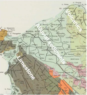
Fig. 1. Scene of the geologic map (Bennett et al., 1981) of the
Kru-eng Aceh River delta showing undifferentiated alluvial sediments in the whole investigation area, adjacent to volcanic rocks (NE) and limestones (SW). Post tsunami ground-water exploration drilling in the alluvial delta has yielded stacks of organic clay, silt, sand, and gravel down to a depth of 220 m.
pensive approach, due to the drilling costs. Common seismic refraction analysis often leads to poor results due to a dis-continuously increasing velocity-depth distribution of shear-waves. Steadily increasing velocities with depth are, how-ever, required for the successful application of the refraction method. Otherwise, false interpretations will often be the consequence. With p-waves, the situation is different; they generally present increasing velocities with depth. For in-stance, at the ground water level the p-wave velocities mostly rise, while shear-wave velocities remain unaffected as they are hardly affected by the presence of pore fluids. In fact, the lack of a continuously increasing velocity-depth function for shear-waves results in many cases to the formation of a high velocity channel wave, which is then often misinterpreted as the half space velocity of the bedrock. Yet, through applica-tion of the shear-wave reflecapplica-tion method, velocity inversions can also be detected.
Within the project “Management of Georisk” (MAN-GEONAD) of the Federal Institute for Geosciences and Nat-ural Resources (BGR), Hanover, high resolution shallow shear-wave reflection seismics was applied in the Indone-sian province Nanggroe Aceh Darussalam, North Sumatra in cooperation with the Government of Indonesia, local coun-terparts, and the Leibniz Institute for Applied Geosciences, Hanover. The investigations were applied together with
en-Fig. 2. Shallow shear-wave site investigation at Blang Padang place,
centre of Banda Aceh city. Foreground: 48 channel Geode system used for seismic data acquisition. Centre: Local mud zone indicat-ing local subsidence of young sediments. Background: Houses of nearly traditional Indonesian building style that were only slightly affected by earthquake shakings. In contrast, the high concrete building (demolition in 2006) shows severe structural damages and partly total collapse due to the earthquake shaking of 26 Dec 2004.
gineering geology and hydrogeologic studies. Knowledge of shallow soil conditions and of the subsurface layer structur-ing is important to understand the complex subsurface be-haviour in the tsunami affected Krueng Aceh River region (Fig. 1). Such knowledge is required for reconstructing safe buildings, sustainable lifelines and infrastructure. Our inves-tigations were not only restricted to fulfil the terms of the Building Codes, but should also contribute to a multidisci-plinary approach of the overall restoration of the area. More-over, application of several methods was aimed to reduce un-certainties in the individual results. The seismic results were integrated into a database called Information System Engi-neering Geology (ISEG) developed by BGR. The database is also hosting the available borehole information, geotechnical cone penetrometer testings (CPT) and data from laboratory analysis of soil and rock samples. In its final stage, ISEG will allow 3D visualization of geotechnical parameters of the various subsurface units in the investigation area.
2 Method
The high resolution shallow shear-wave reflection technique we applied uses specific equipment which can partly not be purchased from standard suppliers. Unlike shear-wave geo-phones that are widely in use in the hydrocarbon exploration industry, shear-wave seismic sources for engineering pur-poses are not commonly available but are still under develop-ment at a few institutions. As shear-wave impulsive sources are affected by problems of signal repeatability, trigger
U. Polom et al.: Shallow shear-wave reflection seismics 137
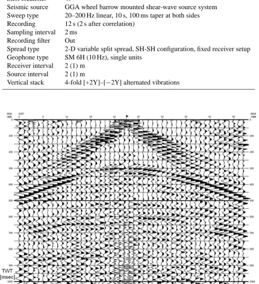
Table 1. Seismic recording parameters.
Period 20 Nov–12 Dec 2005 Instrument GEOMETRICS GEODE Channels/record 48
Shot locations 49
Seismic source GGA wheel barrow mounted shear-wave source system Sweep type 20–200 Hz linear, 10 s, 100 ms taper at both sides Recording 12 s (2 s after correlation)
Sampling interval 2 ms Recording filter Out
Spread type 2-D variable split spread, SH-SH configuration, fixed receiver setup Geophone type SM 6H (10 Hz), single units
Receiver interval 2 (1) m Source interval 2 (1) m
Vertical stack 4-fold [+2Y]–[−2Y] alternated vibrations
Fig. 3. Example of correlated raw record of horizontal shear-waves at profile location Lam Saiun in the centre of the alluvial delta (2 m
geophone spacing, 96 m total spread). The record shows a clear shear-wave reflection hyperbola of 135 m/s rms velocity at 300 ms zero offset, corresponding to a low velocity layer of minimum thickness 20 m. Hyperbolas of later arrivals indicate no significant increase of velocities with depth. Refracted waves as well as the often disturbing Love surface wave are missing due to the presence of compacted soil, i.e. a thin, man made high velocity layer at the surface.
racy, efficient source to ground coupling and present environ-mental violations, shear-wave vibratory sources have become state-of-the-art technology in the hydrocarbon industry. For engineering purposes, the main advantages of the shear-wave reflection method compared to p-wave investigations are (a) higher resolution of subsurface layers due to the lower veloc-ities resulting in smaller wavelengths and (b) higher potential to image folds and cracks. Moreover, the combination of p-and shear-wave techniques allows for direct fluid p-and gas de-tection.
The engineering-type seismic equipment we used includes of a lightweight, highly transportable and flight transporta-tion adapted unit consisting of a modular expandable 48 channel Geometrics GEODE recording system (Fig. 2), sets of single shear- and p-wave geophones and a small, electro-dynamically driven shaker source system for the generation of shear-wave vibration sweeps. The whole shaker system is powered by a car battery and is attached to a wheel bar-row unit for easy transportation in the field. The full equip-ment also contains p- and shear-wave hammer blowing units
138 U. Polom et al.: Shallow shear-wave reflection seismics
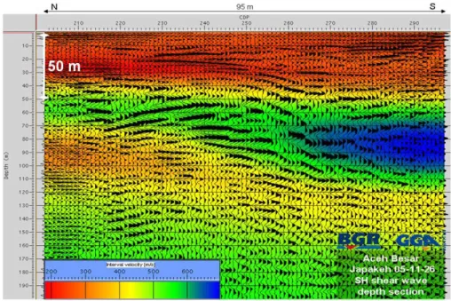
Fig. 4. Depth converted reflection seismic stack section at Japakeh site, colour coded by shear-wave interval velocities derived from reflection
seismic stacking velocities. Red colours show low velocity areas whereas blue colors indicate high velocities. Lateral and vertical averaged shear-wave velocity over the top 30 m (VSav30) is 247 m/s, indicating IBC class SD of stiff soil. The subsurface structure shows folded layer characteristics and thus some strong tectonic activity in the recent past.
in spare, and a DGPS positioning system. The acquisition parameters for the surveys in North Sumatra are given in Ta-ble 1. The shear-wave system enaTa-bles to carry out reflection seismics down to depths between 50 m and 150 m. Frequen-cies of the shaker system were chosen to range from 10 Hz to 330 Hz. An example of the acquired seismic raw data is shown in Fig. 3. Subsequent data processing lead to high resolution images of the subsurface stiffness in terms of the shear-wave velocity and layer structure (Fig. 4).
3 Results and discussions
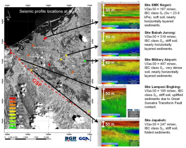
Depth converted 2-D sections of the shallow reflection seis-mic investigations in the Krueng Aceh River Basin show a variety of layer structures in the basin area (Fig. 5). The colour coding of the shear-wave interval velocities and the resultant VSav30 parameters for the individual profiles are self-explanatory. They clearly reflect the heterogenities in mechanical strength within the basin, resulting in VSav30 values of 167 m/s corresponding to IBC soft soil class SF
in the north near the coastline, up to nearly 500 m/s corre-sponding to IBC stiff soil class SC in the eastern part near
the airport. Moreover, whereas profiles in the centre and in the eastern part of the basin display subhorizontal layers, pro-files near the SW border of the basin present huge folded or steeply dipping layers (Fig. 5). Assuming a continuously de-veloping fluviatile sedimentation process, mainly produced by the deposits of the Krueng Aceh River, the folding and
dipping of the basin sediment layers indicate tectonic forcing at the SW border, which is probably related to the activity of the Great Sumatra Fault (GSF). Especially the dipping that is steadily increasing with depth of layers at Lampasi Enking location indicates sequential compressive stress of the basin layers. This finding reveals a significant compressive com-ponent in the overall deformation of the area, different from a pure strike slip movement of the GSF. Clearly, the tectonic deformation at the SW border is archived in the sedimen-tary sequences adjacent to the GSF. Referring to the consid-erable changes in the subsurface stress field due to the 2004 Sumatra-Andaman earthquake, a dip-over-age analysis of the sediment layer tectonics may possibly help to recognize fu-ture georisk for the whole region.
4 Conclusions
The shear-wave reflection seismic site effect evaluation has been found to be a useful tool in the densely populated sedi-mentary regions of Aceh Province. The studies were able to explore the subsurface stiffness down to 100 m depth, and has allowed for a geotechnical site classification in terms of the IBC 2003. Moreover, due to the high resolution achieved by the applied technology, the seismic depth section images give detailed insights into the basin sedimentation history of the Krueng Aceh River delta and can thus be used (a) to explore new areas yielding safe foundations of buildings and (b) to
U. Polom et al.: Shallow shear-wave reflection seismics 139
Fig. 5. Preliminary shake risk map based on average shear wave velocity VSav30 (left). Red colours indicate unfavourable soil stiffness
concerning building foundation whereas green colours indicate stiff soil. Critical soil conditions were detected for areas near the coastline, especially east of the Krueng Aceh River. Other critical areas – not previously expected – were also found near the river bed in the SE part of the delta. GSF denotes the estimated course of the Great Sumatra Fault at the SW border of the basin. Examples of seismic depth sections (right) show the wide variability of the subsurface structures in the basin area. Note colour scaling has been adapted individually for each depth section due to imaging reasons.
identify prospective layers of water aquifers in the tsunami flooded region.
A small vibratory seismic source was also successfully ap-plied in city like areas and in areas of compacted soil. Man made land fillings here are associated with decreasing veloc-ity gradients at shallow depths, yielding an efficient suppres-sion of Love waves and refracted shear-waves in horizontal shear-wave recordings. The resulting seismic depth sections reveal a surprising variety within the Krueng Aceh Basin sed-iments: Near the north coast, in the area of Banda Aceh city, mostly horizontally layered soft to very soft sediments were identified. Sediments in the western part are folded, prob-ably due to tectonic activities related to movements of the Great Sumatra fault zone. Sediments in the eastern part, near the volcanic formations, appear to be less critical in terms of earthquake site effects. Further investigations should share more light on the low velocity spots in the centre of the basin.
Acknowledgements. The authors acknowledge the German
Min-istry of Economic Cooperation and Development and the Republic of Indonesia for funding and supporting this work. Many thanks to T. Rehmann and the staff members of MANGEONAD, Dinas Pertambangan dan Energi, and the Syiah Kuala University of Banda Aceh for their engagement and cooperation during the field campaigns. The authors also thank two anonymous reviewers for helpful suggestions and comments.
Edited by: P. Fabian
140 U. Polom et al.: Shallow shear-wave reflection seismics
References
Bennett, J. D., Bridge, D. McC., Cameron, N. R., Djunuddin, A., Ghazali, S. A., Jeffrey, D. H., Kartawa, W., Keats, W., Rock, N. M. S., Thomson, S. J., and Whandoyo, R.: Geologic map of the Banda Aceh quadrangle, Sumatra, Geological Research and Development Centre, Jalan Diponegoro 57, cable P3G, Bandung, Indonesia, 1981.
DIN 4149: Bauen in deutschen Erdbebengebieten – Lastannahmen, Bemessung und Ausf¨uhrung ¨ublicher Hochbauten, Deutsches In-stitut f¨ur Normung, Beuth-Verlag GmbH, Berlin, 2005 (in Ger-man).
Eurocode 8: Auslegung von Bauwerken gegen Erdbeben – Teil 1: Grundlagen, Erdbebeneinwirkungen und Regeln f¨ur Hochbauten, Deutsche Fassung EN 1998-1, Beuth-Verlag GmbH, 2004 (in German).
Inazaki, T.: Land Streamer: a new system for high-resolution s-wave shallow reflection surveys, Ann. Symp. Environ. Engin. Geophys. Soc. (SAGEEP) Expanded Abstracts, 207–216, 1999. Inazaki, T.: High-resolution S-wave reflection survey in urban
ar-eas using a woven belt type land streamer, Near Surface 2006, September 4–6, Helsinki, Finland, A016, 2006.
International Code Council: International Building Code 2003, ISBN-10 1892395568, ISBN-13 9781892395566, 2003. Purgin, A., Larson, T., and Phillips, A.: Shallow high-resolution
shear-wave seismic reflection acquisition using a land-streamer in the Mississippi River floodplain: potential for engineering and hydrogeologic applications, SAGEEP 2002, February 10– 14, Las Vegas, Nevada, Publication on CD, 2002.