HAL Id: hal-00302876
https://hal.archives-ouvertes.fr/hal-00302876
Submitted on 18 Jun 2007HAL is a multi-disciplinary open access
archive for the deposit and dissemination of sci-entific research documents, whether they are pub-lished or not. The documents may come from teaching and research institutions in France or abroad, or from public or private research centers.
L’archive ouverte pluridisciplinaire HAL, est destinée au dépôt et à la diffusion de documents scientifiques de niveau recherche, publiés ou non, émanant des établissements d’enseignement et de recherche français ou étrangers, des laboratoires publics ou privés.
Operational retrieval of Asian sand and dust storm from
FY-2C geostationary meteorological satellite and its
application to real time forecast in Asia
X. Q. Hu, N. M. Lu, T. Niu, P. Zhang
To cite this version:
X. Q. Hu, N. M. Lu, T. Niu, P. Zhang. Operational retrieval of Asian sand and dust storm from FY-2C geostationary meteorological satellite and its application to real time forecast in Asia. Atmospheric Chemistry and Physics Discussions, European Geosciences Union, 2007, 7 (3), pp.8395-8421. �hal-00302876�
ACPD
7, 8395–8421, 2007Operational retrieval of Asian dust from
FY-2C X. Q. Hu et al. Title Page Abstract Introduction Conclusions References Tables Figures ◭ ◮ ◭ ◮ Back Close
Full Screen / Esc
Printer-friendly Version Interactive Discussion
EGU
Atmos. Chem. Phys. Discuss., 7, 8395–8421, 2007 www.atmos-chem-phys-discuss.net/7/8395/2007/ © Author(s) 2007. This work is licensed
under a Creative Commons License.
Atmospheric Chemistry and Physics Discussions
Operational retrieval of Asian sand and
dust storm from FY-2C geostationary
meteorological satellite and its
application to real time forecast in Asia
X. Q. Hu1,3, N. M. Lu1, T. Niu2, and P. Zhang1
1
Key Laboratory of Radiometric Calibration and Validation for Environmental Satellites (KLRCV), National Satellite Meteorological Center, China Meteorological Administration (NSMC/CMA), Beijing 100081, China
2
Centre for Atmosphere Watch & Services (CAWAS), Chinese Academy of Meteorological Sciences, China Meteorological Administration (CMA), Beijing 100081, China
3
Institute of remote sensing applications, Chinese Academy of Sciences, Beijing 100101, China
Received: 28 March 2007 – Accepted: 23 May 2007 – Published: 18 June 2007 Correspondence to: X. Q. Hu ([email protected])
ACPD
7, 8395–8421, 2007Operational retrieval of Asian dust from
FY-2C X. Q. Hu et al. Title Page Abstract Introduction Conclusions References Tables Figures ◭ ◮ ◭ ◮ Back Close
Full Screen / Esc
Printer-friendly Version Interactive Discussion
EGU
Abstract
This paper describes an operational retrieval algorithm for the sand/dust storm (SDS) from FY-2C/S-VISSR (Stretched – Visible and Infrared Spin-Scan Radiometer) devel-oped at the National Satellite Meteorological Center (NSMC) of China. This algorithm, called Dust Retrieval Algorithm based on Geostationary Imager (DRAGI), is based on
5
the optical and radiative physical properties of SDS in mid-infrared and thermal infrared spectral regions as well as the observation of all bands in the geostationary imager, which include the Brightness Temperature Difference (BTD) in split window channels, Infrared Difference Dust Index (IDDI) and the ratio of middle infrared reflectance to vis-ible reflectance. It also combines the visvis-ible and water vapor bands observation of the
10
geostationary imager to identify the dust clouds from the surface targets and meteo-rological clouds. The output product is validated by and related to other dust aerosol observations such as the synoptic weather reports, surface visibility, aerosol optical depth (AOD) and ground-based PM10 observations. Using the SDS-IDDI data and a data assimilation scheme, the dust forecast model CUACE/Dust achieved a substantial
15
improvement to the SDS predictions in spring 2006.
1 Introduction
SDS is recognized to have a very wide range of environmental impacts. When it occurs, SDS can move forward like an overwhelming tide with drifting sands to bury farmlands, denude steppe, attack human settlements, reduce the temperature, pollute the
atmo-20
sphere, hurt animals and destroy mining and communication facilities. On the other hand, atmospheric mineral-dust loading is one of the largest uncertainties in global climate-change modeling and is known to have an important impact on the radiation budget and atmospheric instability. Brooks (2000) provided tentative evidence of a pos-sible positive feedback mechanism involving rainfall and dust variability. Dust also has
25
ACPD
7, 8395–8421, 2007Operational retrieval of Asian dust from
FY-2C X. Q. Hu et al. Title Page Abstract Introduction Conclusions References Tables Figures ◭ ◮ ◭ ◮ Back Close
Full Screen / Esc
Printer-friendly Version Interactive Discussion
EGU
has a major influence on soil characteristics, oceanic productivity, and air chemistry. Moreover, because of the thousands of kilometers over which dust is transported, it has an influence at great distances from its sources (Gong et al., 2006; Middleton and Goudie, 2001).
Since the surface observations are generally sparse in the desert region, it is difficult
5
to locate the origin as well as the movement of dust outbreak. The disadvantage of surface observation with coarse horizontal resolution can be overcome with the aid of satellite data. Earlier researchers utilized satellite visible and infrared measurements to detect dust storm over land and water (Shenk and Curran, 1974) and others utilized visible spectrum to monitor dust outbreaks as well as to estimate dust optical depth
10
over oceanic regions (Carlson, 1978; Norton et al., 1980). However, monitoring dust aerosol outbreaks over land using satellite visible and near-infrared data is difficult due to the bright underlying desert surface. More recent studies have shown the significant potential of using thermal infrared data to detect Saharan dust over land (Cavtenet et al., 1992; Legrand et al., 1992; Legrand et al., 1987; Legrand et al., 1989; Legrand et
15
al., 2001). It was shown that that dust haze, through the impact of radiation process, cuts down the heating effect on land surface during the daytime and slows down the cooling effect near ground surface during the nighttime. A correlation between the brightness temperature difference (11–3.7 µm) and dust outbreaks was proposed by Ackerman (1989) and later a tri-spectral (8, 11 and 12µm) technique for detecting dust
20
over water and for distinguishing dust plumes from water/ice clouds was developed (Ackerman, 1997). Some algorithms for the detection of airborne volcanic ash in the last years have been introduced such as three infrared bands (3.9, 10.7, and 12.0µm)
method (Ellrod et al., 2003; Pergola et al., 2004) and four spectral channels (0.65, 3.75, 11, and 12µm) method (Pavolonis et al., 2006). These techniques can be used for the
25
reference of dust storm detection because there are some similar characteristics in spectral-absorption and scattering between them in atmosphere.
This paper describes an operational retrieval algorithm of Asian SDS from FY-2C satellite developed by integrating all optical and radiance mechanism of dust storm in
ACPD
7, 8395–8421, 2007Operational retrieval of Asian dust from
FY-2C X. Q. Hu et al. Title Page Abstract Introduction Conclusions References Tables Figures ◭ ◮ ◭ ◮ Back Close
Full Screen / Esc
Printer-friendly Version Interactive Discussion
EGU
middle infrared and thermal infrared bands. The dust storm detection product is one of the most important operational products from Data Processing Center (DPC) of FY-2C ground application system.
2 Dust retrieval algorithm based on geostationary imager
2.1 FY-2C Satellite
5
FY-2C is China’s first operational geostationary meteorological satellite operated by Na-tional Satellite Meteorological Center (NSMC) of China Meteorological Administration (CMA). It was successfully launched on 19 October 2004, as the improved succes-sor of previous experimental GEO satellites FY-2A and FY-2B which were launched on 10 June 1997 and 25 June 2000, respectively. The satellite was placed in the
10
geostationary orbit over 105◦E with a field of view that covers the areas of Asian and Pacific Region. FY-2C is spin-stabilized with a rotation velocity 100 rpm. The main payload onboard, the upgraded Stretched – Visible and Infrared Spin-Scan Radiome-ter (S-VISSR), features 5 spectral bands (1 VIS and 4 IR) (details in Table 1). These new specifications of the sensor improve the following instrumental observation
func-15
tions: (1) the capability of detecting and calculating water vapor contents, to support semi-transparent ice cloud detecting, and to have a better accuracy of atmospheric absorption correction for better sea temperature estimation; (2) improved temperature resolution of the IR bands and SNR of the VIS band; support of split window applica-tion; (3) the data quantization level of the IR bands has been increased from 256 (8 bit)
20
ACPD
7, 8395–8421, 2007Operational retrieval of Asian dust from
FY-2C X. Q. Hu et al. Title Page Abstract Introduction Conclusions References Tables Figures ◭ ◮ ◭ ◮ Back Close
Full Screen / Esc
Printer-friendly Version Interactive Discussion
EGU
2.2 Algorithm physical basis 2.2.1 IR split widows technique
The most commonly used satellite-based volcanic ash detection technique is often re-ferred to as the “reverse absorption” technique (Prata, 1989a; Prata, 1989b), which uses brightness temperatures in the 11 and 12µm regions of the spectrum. SDS has
5
the similar absorption characteristic as the volcanic silicate in the thermal region (Ack-erman, 1997). Quartz displays a strong spectral dependence in the imaginary index of refraction, suggesting that spectral difference techniques may be successful in detect-ing SDS with a large sand component. At the same time, the thermal infrared spectra of minerals strongly depend on the particle size and there is a temperature difference
10
between the surface and the SDS in air (Wald et al., 1998). When the dust layer is optically thick, the dust particles cause a negative brightness temperature difference (i.e. BTD[11, 12]<0, where BTD[11, 12] defines the 11–12-µm brightness temperature
difference). Using BTD[11, 12] to discriminate dust cloud from meteorological clouds is called the “IR split windows” technique.
15
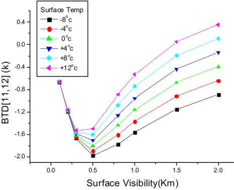
Figure 1 shows the simulated BTD[11, 12] signals of different dust loading using MODTRAN radiative transfer model (Berk et al., 1989) at the middle-latitude winter. It is found that no matter what the surface temperatures are, the absolute value of negative BTD[11, 12] always increases with the higher surface visibility (means more dust loading ) when the visibility is not lower than 500 m ,but the variation trend of the
20
absolute BTD[11, 12] reverses at the point where the surface visibility becomes very poor (heavy dust storm, visibility is less than 500 m). This kind of feature for SDS is found from the actual image observed by the satellite. In addition, BTD[11, 12] in the thermal split window channels depends on the density of air dust. The magnitude of negative BTD[11, 12] is driven by (1) the thickness of the dust layer (temperature), (2)
25
the mass per area of dust cloud (concentration), (3) the component of airborne dust ( refractive index) and (4) the size of the dust particles (size distribution). The dust BTD[11, 12] in different height (Tbb), different mean effective radius (Ref) and different
ACPD
7, 8395–8421, 2007Operational retrieval of Asian dust from
FY-2C X. Q. Hu et al. Title Page Abstract Introduction Conclusions References Tables Figures ◭ ◮ ◭ ◮ Back Close
Full Screen / Esc
Printer-friendly Version Interactive Discussion
EGU
loading (AOD) over the same surface was also simulated by DISORT .(Zhang et al., 2006). This simulation can explain most of the signal from satellite observation of the dust aerosols.
Unfortunately, such a method does not often seem to have a “stable” behaviour, showing a strong dependence on the observational conditions and/or on the nature
5
(such as underlying type, surface winds and mixture of clouds) and characteristics of dust clouds. Moreover, a high concentration of atmospheric water vapour can compen-sate for the reverse absorption effect of dust (Simpson et al., 2000). There is also the annual cycle of surface heating due to variations in the solar illumination, but this effect can easily be accounted for.
10
2.2.2 Infrared Difference Dust Index (IDDI)
To detect the presence of desert dust over Africa in view of climatological applications, the Infrared Difference Dust Index (IDDI) was developed as a satellite dust product de-signed from midday Meteosat-IR imagery, specifically for dust remote sensing in arid regions such as the Sahel and Sahara (Legrand et al., 2001). To take advantage of
15
the impact of dust aerosols on the thermal infrared radiance outgoing to space, IDDI is based on observing thermal radiation (10–12µm) emitted by the same scene over
the course of several days, during which time the mineral aerosol content of the at-mosphere has changed. The principal assumptions behind this method are (i) the radiance emitted by the surface is constant or linearly varying over the time period of
20
the observations, and (ii) one of the days is dust free. In the presence of dusts, the outgoing longwave radiation is attenuated along its path through the dust layer, result-ing in a reduction in the outgoresult-ing longwave radiation when compared to a clear day. Furthermore, the solar flux available to heat the surface is reduced by the presence of dust aerosols due to enhanced scattering of shortwave radiation, which in turn leads
25
to a drop in the surface temperature. Both of these effects reduce the thermal infrared radiation emitted to space, thereby increasing the contrast between observations ob-tained during clear and dusty conditions. This thermal contrast can in turn be related
ACPD
7, 8395–8421, 2007Operational retrieval of Asian dust from
FY-2C X. Q. Hu et al. Title Page Abstract Introduction Conclusions References Tables Figures ◭ ◮ ◭ ◮ Back Close
Full Screen / Esc
Printer-friendly Version Interactive Discussion
EGU
to dust loading. The Infrared Difference Dust Index (IDDI) is defined as:
IDDI = Ts− Tbb (1)
where Tbb is the observed brightness temperature by sensor from space, Ts is the underlying background surface brightness temperature which is obtained in clear sky under the same condition.
5
2.2.3 Middle Infrared method
Ackerman (1989) proposed a technique to track the dust cloud based on the difference between band 3 and 4 of AVHRR. The measurements of refractive index of dust show that large differences exist at wavelengths of 3.7 and 11 µm. The imaginary part of the index of refraction at 11µm is approximately an order of magnitude greater than
10
that at 3.7µm. Therefore, large differences may exist in the equivalent black-body temperatures (BT) at these two bands (i.e. BTD [3.7, 11]) in the presence of a dust layer, thus providing a method to locate and track dust outbreaks. During the night, dust tends to produce a negative BTD [3.7, 11] and different thresholds are required.
In addition to this, the single scatter albedo (SSA) of the airborne particles is a strong
15
function of particle size at wavelengths less than about 2µm, with smaller particles
having a greater probability of being scattered given an extinction event than large particles (Pavolonis et al., 2006). At visible wavelengths (∼0.65 µm), with the exception of very small dust particles (e.g., reff = 0.33 µm), the SSA of dust is significantly smaller than for water and ice clouds, which always have SSA values very close to unity. In
20
the middle-infrared at 3.7µm, both dust and water clouds will scatter photons more
often than ice clouds. Dust and water clouds can often have similar single scatter albedos in the middle-infrared. As at visible wavelengths, smaller particles tend to have larger SSA values than larger particles, regardless of the composition. Using above information as a reference, Pavolonis et al. (2006) developed a new automated
25
ash detection technique by the ratio of particle reflectance at 3.7µm (R [3.7]) to that
ACPD
7, 8395–8421, 2007Operational retrieval of Asian dust from
FY-2C X. Q. Hu et al. Title Page Abstract Introduction Conclusions References Tables Figures ◭ ◮ ◭ ◮ Back Close
Full Screen / Esc
Printer-friendly Version Interactive Discussion
EGU
detection. For a given optical depth, RAT [3.7, 0.65] for dust clouds will often be larger than that for water and ice clouds. However, for a given cloud optical depth, the RAT [3.7, 0.65] for water clouds with small droplets (e.g., reff <4.0 µm) and dust plumes may be very similar. This suggests that the edges of stratus and fair-weather cumulus clouds may have similar RAT [3.7, 0.65] values as some dust plumes.
5
2.3 Algorithm implementation
An operational retrieval algorithm of dust detection is developed using the data of all bands of FY-2C and called Dust Retrieval Algorithm based on Geostationary Imager (DRAGI) since 2001. The production procedure of dust detection from DRAGI is illus-trated in Fig. 2. There are three key steps in retrieving the SDS location and loading,
10
following the three algorithms in Sect. 2.2: (1) BTD [11, 12] and BTD [3.7, 11] calcula-tions based on original image (OI) of IR bands, (2) RAT [3.7, 0.65] calculacalcula-tions based on Reference image (RI) and Difference Image (DI) and (3) cloud mask generations based on above middle-parameters or factors. The final output products including dust area, location and dust loading IDDI are generated.
15
2.3.1 Generating RI and DI
Figure 3 exhibits the OI, RI and DI covering Northeast Asia on 13 March 2006, at 06:00 UTC. The period used for constructing the RI is ten days (4–13 March). A color scale with the corresponding brightness temperature is available for OI and RI.
The clouds are rather well distinguished due to their brightness and structure.
Con-20
versely, dust plumes are not easily discernable because their radiative effect is con-fused with the pattern of the ground surface radiative effect. The RI image is a clear and clean image showing only the unvarying surface contribution. The coldest sur-faces lie in the north and the hottest ones tend to lie in the desert and Gobi in North China. The Mountains and Tibet plateau appear colder than surrounding regions. The
25
ACPD
7, 8395–8421, 2007Operational retrieval of Asian dust from
FY-2C X. Q. Hu et al. Title Page Abstract Introduction Conclusions References Tables Figures ◭ ◮ ◭ ◮ Back Close
Full Screen / Esc
Printer-friendly Version Interactive Discussion
EGU
of large amount of atmospheric water vapor. DI image shows only the variable atmo-spheric radiative effects. Clouds seen in the OI are restituted (South China, east of Tibet and Russia). A strong dust plume, easy to discriminate from the clouds due to its smoothness and coherence, appears in the Takalimakan in Xinjiang Province.
2.3.2 BTD and RAT calculations
5
BTDs are calculated easily using the subtract operation of brightness temperatures of corresponding bands, but the RAT calculation is a little more complicated. During the daytime, the radiance at middle infrared band 3.7µm has both significant solar
and thermal components. To obtain an estimate of the 3.7µm reflectance due to the
solar component, the contribution to the total radiance from thermal emission must
10
be approximated and removed. As suggested by Pavolonis et al. (2006), the 3.7µm
reflectance estimate (R[3.7]) is calculated as:
R[3.7] = (L(3.7) − B(T11))/(Lo ∗ u − B(T11)) (2) where L(3.7] is the observed 3.7µm radiance, B(T11) is the Planck function radiance at 3.7µm that is calculated using the observed 11 µm brightness temperature, Lo is
15
the solar constant for the 3.7µm band (adjusted for earth-sun distance), and u is the
cosine of the solar zenith angle. After that, the ratio RAT [3.7, 0.65] can be calculated. 2.3.3 Cloud masking
Several techniques were adapted to identify the cloud pixel in the OI, including the high reflectance method in VIS channel, the spatial coherence method, IR BTD threshold
20
method, correlation method of water vapor channel and IR channel. During the dust identification, the quality of cloud masks directly affects the result of dust detection. The dust cloud needs to be discriminated from the meteorological cloud to avoid the confusion between cloud and dust targets, which causes missing or false detections of dust targets. In the present, cloud mask is one of the primary operational products
ACPD
7, 8395–8421, 2007Operational retrieval of Asian dust from
FY-2C X. Q. Hu et al. Title Page Abstract Introduction Conclusions References Tables Figures ◭ ◮ ◭ ◮ Back Close
Full Screen / Esc
Printer-friendly Version Interactive Discussion
EGU
of Data Processing Center (DPC) of FY-2C ground application system, but DRAGI does not use this ready-made product because of its confusion between dust and meteorological cloud but generates the cloud mask independently based on a set of the thresholds of meteorological cloud before dust identification.
2.3.4 Dust identification and retrieval
5
All dust identification factors are based on above the physical theories and then com-bined to discriminate the dust storm pixel from the observation. Figure 3 show a dust case in Taklamakan in Xinjiang Province by FY-2C on 13 March 2006. The apparent attenuation of outgoing surface brightness temperature can been seen from the OI, RI and DI images. At the same time, the negative BTD [11,12] is very clear of dust area.
10
High positive BTD [3.7, 11] and high RAT [3.7, 0.65] also show the strong scattering of airborne dust. In addition to this, other bands data including water vapor image are used to identify the dust targets. They are combined into a dynamic threshold-based classification method. The values of these thresholds are changed according the ob-servation time and geometry, underlying type and surface temperature (season). A set
15
of thresholds has been established for the FY-2C observation of dust cases.
The first step of dust thresholds construction is to find the training sample for dust area by manual-identification. The threshold of each channel for the dust target is determined by histogram analysis of the target and the identification is conducted au-tomatically using these thresholds. The classification thresholds are modified by
val-20
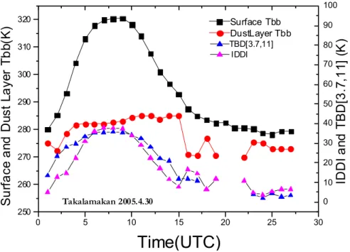
idations with actual dust case. A dynamic threshold corresponding to the different observation time is used on the diurnal circle of the BTD and IDDI. Figure 4 shows the surface brightness temperature and IDDI diurnal circle.
Finally the dust occurrence area image (IDDI Grid image or IDDI image overlaying false RGB image) and corresponding IDDI values (Fig. 3h) were produced to
indi-25
cate the dust loading – SDS-IDDI by combining the BTD, IDDI, RAT and the spectral classification parameters. This product is generated every hour in daytime at 01:00– 09:00 UTC. A whole dust event animation detected by FY-2C is eventually obtained
ACPD
7, 8395–8421, 2007Operational retrieval of Asian dust from
FY-2C X. Q. Hu et al. Title Page Abstract Introduction Conclusions References Tables Figures ◭ ◮ ◭ ◮ Back Close
Full Screen / Esc
Printer-friendly Version Interactive Discussion
EGU
daily in spring.
3 Validation and results analysis
3.1 Validation with ground-based observation
There are many kinds of surface observations for weather and special observation for SDS. Murayama et al. (2001) introduced a ground-based network including the lidar,
5
sky radiometer, and optical particle counter that has been in use since 1997 to monitor the Asian dusts during springtime. Huge Asian dust events that occurred in the middle of April 1998 were captured by this network. CMA began to establish an operational observation network for SDS in north China since 2002 (Wang et al., 20071). These observations provide a full range of ground-based validation and relationship analysis
10
data sources for remote sensing from space.
3.1.1 Validation using synoptic SDS and PM10 data
The ground-based synoptic observations for SDS monitoring are made at the CMA weather stations national wide. The visual visibility at each site is reported every three hours and four levels of SDS, i.e. floating dust, blowing dust, sand/dust storm (SDS),
15
and severe SDS, are classified (Yang et al., 2007), which correspond to a visibility of>10 km, 1 km–10 km, 500 m–1 km and <500 m, respectively. Figure 5a shows the
FY-2C dust detection results compared with the dusty records from weather ground stations (Fig. 5b). They are every consistent in dust event distribution except for areas with cloud covers. A good agreement was obtained between them and a quantitative
20
1
Wang, Y. Q., Zhang, X. Y., Gong, S. L., Zhou, C. H., Hu, X. Q., Liu, H. L., Niu, T., and Yang, Y. Q.: Surface observation of sand and dust storm in East Asia and its application in CUACE/Dust forecasting system, Atmos Chem. Phys. Discuss., submitted, 2007.
ACPD
7, 8395–8421, 2007Operational retrieval of Asian dust from
FY-2C X. Q. Hu et al. Title Page Abstract Introduction Conclusions References Tables Figures ◭ ◮ ◭ ◮ Back Close
Full Screen / Esc
Printer-friendly Version Interactive Discussion
EGU
relation between SDS-IDDI and visibility was established at various stations by the following nonlinear equation:
SDS − IDDI = A1 ∗ exp(−V IS/t1) + A0 (3) Examples of such relationship at two locations of Hetian [37.13◦N, 79.93◦E] and Tazhong [39.00◦N, 83.67◦E] are shown in Fig. 6 with fitting constants of A1, t1 and
5
A0. Obviously, these constants are location dependent. Niu et al. (2007) has
evalu-ated all the net work data in China with the SDS-IDDI and developed a nation wide data base for the constants used in converting the visibility to SDS-IDDI in CUACE/Dust dust data assimilation scheme.
During the dust weather day, PM10 observation can validate the results from
satel-10
lite observation exactly. From the PM10 value distribution at the same time, we can see the dust outbreak impacting area which is very consistent with FY-2C IDDI spatial distribution. Figure 5c and 5d respectively show the IDDI image and PM10 value of one dust case at 04:00 UTC in 28 April 2005.
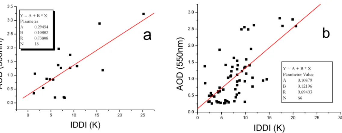
3.1.2 Validation using AOD
15
Since the SDS IDDI reflects the column loading of dust aerosols as the AOD by ground-based sunphotometer, a close relationship should exist. Figure 7 shows the relation-ship between AOD and SDS IDDI at Dunhuang AERONET site and a site in north China. During the dusty weathers, the AOD and SDS-IDDI has the following relation-ship:
20
AOD = A + B ∗ IDDI
where A and B are the fitting coefficients. When a heavy SDS occurs, there is no
ACPD
7, 8395–8421, 2007Operational retrieval of Asian dust from
FY-2C X. Q. Hu et al. Title Page Abstract Introduction Conclusions References Tables Figures ◭ ◮ ◭ ◮ Back Close
Full Screen / Esc
Printer-friendly Version Interactive Discussion
EGU
3.2 Applications of FY-2C SDS detection 3.2.1 The dust outbreak on 9 March 2006
Northeast Asia, including North China, Mongolia, Korea and Japan, covering 70◦ E– 140◦E and 25◦N–60◦N, is chosen as the domain for the operational dust product of FY-2C. A SDS distribution is generated from all results at one hour interval every day.
5
Figure 8 shows the evolution of the first severe SDS process on 9 March in spring 2006 at 02:00, 04:00, 06:00 and 08:00 UTC. At the beginning phases, the dust outbreak formed at the border area between Mongolia and China at 02:00 UTC, and then it strengthened quickly in two hours and extended to the middle-west region. At the same time there was another relatively weak dust event came into being in the Takalimakan
10
desert in Xinjiang province. The dust storm process had already attached into Gansu, Ningxia and Shanxi provinces in afternoon of 9 March. Surface observations confirmed the detection of this dust process by FY-2C (Wang et al., 20071; Yang et al., 2007). 3.2.2 Long term detection analysis – spring 2006
To evaluate a complete picture of the dust events in a dusty season, all the dust
de-15
tection results in every hour can be accumulated to form monthly or seasonally mean SDS distributions for a dust occurrence frequency analysis. Over the arid and semi-arid regions of northern China and Mongolia, the dominant aerosol types are soil-dust particles originating in the desert and the Gobi in north China. Therefore the mean SDS-IDDI can be interpreted as dust emission and transport ranges. In order to use
20
the SDS-IDDI as a means of measuring atmospheric dust loading, cloud must be iden-tified and either masked or removed when conduct the mean processing monthly.
Figure 9 shows a spatial distribution of the totally dusty weather days during March– May, 2006. Three dust emission areas are visualized including Takilimakan, Badain Ju-ran and Onqin Daga sand areas. This is consistent with the surface observations which
25
ACPD
7, 8395–8421, 2007Operational retrieval of Asian dust from
FY-2C X. Q. Hu et al. Title Page Abstract Introduction Conclusions References Tables Figures ◭ ◮ ◭ ◮ Back Close
Full Screen / Esc
Printer-friendly Version Interactive Discussion
EGU
northern China source (Wang et al., 20071).
3.2.3 SDS data assimilation for CUACE/Dust in spring 2006
The SDS-IDDI retrieved from the FY-2C has been used in a data assimilation sys-tem (DAS) (Niu et al., 2007) developed for the operational SDS forecasting syssys-tem – CUACE/Dust. With other surface observation data, SDS-IDDI has substantially
en-5
hanced the prediction efficiency of CUACE/Dust. The seasonal mean TS score in-creased from 0.22 without DAS to 0.31 with DAS.
4 Conclusions
An operational dust detection algorithm that utilizes the multi-spectral channels of me-teorological satellite geostationary imager from FY-2C was presented in this paper. The
10
outputs of the dust detection provide a complete picture of the emission and transports of SDS outbreaks. The results indicate that the new DRAGI algorithm, which integrates several techniques including BTD, IDDI and RAT, is not only more sensitive to the pres-ence of dust aerosols but also generally less prone to false alarms than the traditional split windows algorithm.
15
The retrieval results SDS-IDDI by this algorithm were compared with reasonable agreements to the synoptic data and other dust quantitative observations, including visibility, AOD and PM10. Relationships between SDS-IDDI and visibility and AOD were established to enable the conversion of SDS-IDDI to other SDS quantities. These relationships have been used in a SDS assimilation system to improve the forecasting
20
accuracy of SDS in East Asia.
The new generation of instruments like SEVIRI onboard MSG offers an even bet-ter opportunity to detect dust clouds, especially at night, and future sensors such as the Advanced Baseline Imager (ABI) on the GOES-R platform (2013) and the Visi-ble/Infrared Imager/Radiometer Suite (VIIRS) on the NPOESS platform (2008) will also
ACPD
7, 8395–8421, 2007Operational retrieval of Asian dust from
FY-2C X. Q. Hu et al. Title Page Abstract Introduction Conclusions References Tables Figures ◭ ◮ ◭ ◮ Back Close
Full Screen / Esc
Printer-friendly Version Interactive Discussion
EGU
offer additional operational capabilities. Future work will focus on utilizing these addi-tional capabilities for automated dust detection during the day and night. The daytime detection philosophy can be applied to infrared channels to improve nighttime detec-tion.
Acknowledgements. The authors wish to thank for the financial supports from the National
5
Basic Research Program of China (2006CB403701) for this project. Thanks for the support from the National Natural Science Foundation of China (Project ID: 40606043). Special thanks to S. L. Gong of Environment Canada for his scientific advice and hard work to polish this manuscript.
References
10
Ackerman, S. A.: Using the radiative temperature difference at 3.7 and 11 µm to track dust outbreaks, Remote Sens. Environ., 27 129–133, 1989.
Ackerman, S. A.: Remote Sensing aerosols using satellite infrared observation, J. Geophys. Res., 102, 17 069–17 079, 1997.
Berk, A., Berstein, S., and Robertson, D. C.: MODTRAN: a medium resolution model
15
LOWTRAN-7, Geophys. Lab., Hanscom AFB, MA, 1989.
Brooks, N.: Dust-climate interactions in the Sahel-Sahara zone of northern Africa, with partic-ular reference to late twentieth century Sahelian drought. PhD Thesis Thesis, University of East Anglia, Norwich, UK, 2000.
Carlson, T. N.: Atmospheric turbidity in Saharan Dust Outbreaks as Determined by Analyses
20
of Satellite Brightness Data, Mon. Wea. Rev., 107, 322–335, 1978.
Cavtenet, G., Legrand, M., Cautene, S., Bonnel, B. and Brognie, G.: Thermal Impact of Saha-ran Dust Land. Part I: Simulation, J. Appl. Meteorol., 31, 166–180, 1992.
Ellrod, G. P., Connell, B. H., and Hillger, D. W.: Improved detection of airborne volcanic ash using multispectral infrared satellite data, J. Geophys. Res., 108, AAC6.1-AAC6.13, 2003.
25
Simpson, J. J., Hufford, G., Pieri, D., and Berg, J.: Failures in detecting volcanic ash from a satellite-based technique, Remote Sens. Environ. 72, 191–217, 2000.
ACPD
7, 8395–8421, 2007Operational retrieval of Asian dust from
FY-2C X. Q. Hu et al. Title Page Abstract Introduction Conclusions References Tables Figures ◭ ◮ ◭ ◮ Back Close
Full Screen / Esc
Printer-friendly Version Interactive Discussion
EGU
C. S.: A Simulated Climatology of Asian Dust Aerosol and its Trans-Pacific Transport 2. Interannual Variability and Climate Connections, J. Climate, 19, 104–122, 2006.
Legrand, M., Cautenet, G., and Burie, J. C.: Thermal Impact of Saharan Dust over Land. Part 11: Application to Satellite IR Remote Sensing J. Appl. Meteorol., 181–193, 1992.
Legrand, M., Desbois, M., and Vovor, K.: Satellite Detection of Saharan Dust Optimized
Imag-5
ing during Nighttime, J. Climate, 1, 256–264, 1987.
Legrand, M., Bertrand, J. J., Desbois, M., Menenger, L., and Fouquart, Y.: The Potential of Infrared Satellite Data for the Retrieval of Sahara-Dust Optical Depth over Africa, J. Appl. Meteorol., 28, 309–319, 1989.
Legrand, M., Plana-Fattori, A. and N’doum ´e, C.: Satellite detection of dust using the IR imagery
10
of Meteosat: 1. Infrared difference dust index, J. Geophys. Res., 106, 18 251–18 274, 2001. Middleton, N. J. and Goudie, A. S.: Saharan dust: Sources and trajectories. Transactions of the
Institute of British Geographers NS, 26, 165–81, 2001.
Murayama, T., Sugimoto, N., and Uno, I.: Ground-based network observation of Asian dust events of April 1998 in east Asia, J. Geophys. Res., 106, 18 317–18 330, 2001.
15
Niu, T., Gong, S. L., Zhu, G. F., Liu, H. L., Hu, X. Q., Zhou, C. H., Wang, Y. Q., and Zhang, X. Y.: Data Assimilation of Dust Aerosol Observations for CUACE/Dust Forecasting System, Atmos. Chem. Phys. Discuss., in press, 2007.
Norton, C. C., Mosher, F. R., Hinton, B., Martin, D. W., Santek, D., and Kuhlow, W.: A Model for Calculating Desert Aerosol Turbidity over the Oceans from Geostationary Satellite Data, J.
20
Appl. Meteorol., 19, 633–644, 1980.
Pavolonis, M. J., Feltz, W. F., Heidinger, A. K., and Gallina, G. M.: A Daytime Complement to the Reverse Absorption Technique for Improved Automated Detection of Volcanic Ash, J. Atmos. Oceanic Technol., 23, 1422–1444, 2006.
Pergola, N., Tramutoli, V., Marchese, F., Scaffidi, I., and Lacava, T.: Improving volcanic ash
25
cloud detection by a robust satellite technique, Remote Sens. Environ., 90, 1–22, 2004. Prata, A. J.: Observations of volcanic ash clouds in the 10-12-micron window using AVHRR/2
Data, Int. J. Remote Sens., 10, 751–761, 1989a.
Prata, A. J.: Radiative transfer calculations for volcanic ash clouds, Geophys. Res. Lett., 16, 1293–1296, 1989b.
30
Shenk, W. E. and Curran, R. J.: The Detection of Dust Storms Over Land and Water With Satellite Visible and Infrared Measurements, Mon. Weather Rev., 102, 830–837, 1974. Wald, A. E., Kaufman, Y. J., Tanre, D., and Gao, B. C.: Daytime and nighttime detection of
ACPD
7, 8395–8421, 2007Operational retrieval of Asian dust from
FY-2C X. Q. Hu et al. Title Page Abstract Introduction Conclusions References Tables Figures ◭ ◮ ◭ ◮ Back Close
Full Screen / Esc
Printer-friendly Version Interactive Discussion
EGU
mineral dust over desert using the thermal IR, J. Geophys. Res., 103, 32 307–32 313, 1998. Yang, Y. Q., Hou, Q., Zhou, C. H., Liu, H. L., Wang, Y. Q. and Niu, T.: A Study on Sand/dust
Storms over Northeast Asia and Associated Large-Scale Circulations in Spring 2006, Atmos. Chem. Phys. Discuss., accepted, 2007.
Zhang, P., Lu, N.-m., Hu, X.-q., and Dong, C.-h.: Identification and physical retrieval of dust
5
storm using three MODIS thermal IR channels, Global and Planetary Change, 52, 197–206, 2006.
ACPD
7, 8395–8421, 2007Operational retrieval of Asian dust from
FY-2C X. Q. Hu et al. Title Page Abstract Introduction Conclusions References Tables Figures ◭ ◮ ◭ ◮ Back Close
Full Screen / Esc
Printer-friendly Version Interactive Discussion
EGU
Table 1. Specification of S-VISSR /FY-2C. Table1 1 Specification of S-VISSR /FY-2C
S Sppeecciiffiiccaattiioonn//ssppaacceeccrraafftt FFYY--22AA//22BB FFYY--22CC V Viissiibbllee 00..5500--11..0055 00..5555--00..9900 I IRR1111::1100..3300--1111..3300 I IRRtthheerrmmaall 1100..55--1122..55 I IRR1122::1111..5500--1122..5500 M Miidd--IIRR NNOO 33..5500--44..0000 B Baannddss μμmm I IRR WWaatteerrvvaappoorr 66..3300--77..6600 66..3300--77..6600 V Viissiibbllee 4400 3355 I IFFGGOOVV ( (µµrraadd)) IIRR((aallll44bbaannddss)) 116600 114400 v viissiibbllee 11..4444 55..7766 S Sppaattiiaallrreessoolluuttiioonn ( (kkmm)) IIRR((aallll44bbaannddss)) 11..2255 55 V Viissiibbllee((rreefflleeccttaannccee)) 00--9988%% 00--9988%% I IRR((TTBB)) 118800--332200KK 118800KK--333300KK M Miidd--IIRR((TTBB)) NNOO 118800KK--334400KK R RaannggeeooffDDyynnaammiicc W Waatteerrvvaappoorr((TTBB)) 220000--330000KK 119900KK--330000KK V Viissiibbllee 66bbiittss 66bbiittss D DaattaaQQuuaannttiizzaattiioonn I IRR((aallll44bbaannddss)) 88bbiittss 1100bbiittss
ACPD
7, 8395–8421, 2007Operational retrieval of Asian dust from
FY-2C X. Q. Hu et al. Title Page Abstract Introduction Conclusions References Tables Figures ◭ ◮ ◭ ◮ Back Close
Full Screen / Esc
Printer-friendly Version Interactive Discussion EGU 0.0 0.5 1.0 1.5 2.0 -2.0 -1.6 -1.2 -0.8 -0.4 0.0 0.4
B
T
D
[1
1
,1
2
]
(k
)
Surface Visibility(Km)
Surface Temp -8oc -4oc 0oc +4oc +8oc +12ocFig. 1. The relationship between surface visibility and temperature differences as a function of ground surface temperatures for middle latitude winter atmosphere.
ACPD
7, 8395–8421, 2007Operational retrieval of Asian dust from
FY-2C X. Q. Hu et al. Title Page Abstract Introduction Conclusions References Tables Figures ◭ ◮ ◭ ◮ Back Close
Full Screen / Esc
Printer-friendly Version Interactive Discussion EGU -FY-2C Disk image Reference Image MultiSpectral Classification BTD[3.75,11]BTD[11,12] Projection & Calibration Maximum BT in 10 days Dust indication IDDI Dust loading RAT[3.75,0.65] Dust Identification Cloud Masking
ACPD
7, 8395–8421, 2007Operational retrieval of Asian dust from
FY-2C X. Q. Hu et al. Title Page Abstract Introduction Conclusions References Tables Figures ◭ ◮ ◭ ◮ Back Close
Full Screen / Esc
Printer-friendly Version Interactive Discussion
EGU FY-2C false color RGB image (R:IR11; IR11 OI Image
G: visible; B: water vapor )
a b
FY-2C IR11 RI Image IR11 DI Image
c d
FY-2C BTD[11, 12] Image FY-2C BTD[3.7, 11] Image
e f
FY-2C IR1 RAT[3.7,0.65] Image IR11 IDDI Image
g h
Figure 3
Fig. 3. Illustration of some bands images, calculated images and dust identification IDDI image on 13 March 2006, at 06:00 UTC.
ACPD
7, 8395–8421, 2007Operational retrieval of Asian dust from
FY-2C X. Q. Hu et al. Title Page Abstract Introduction Conclusions References Tables Figures ◭ ◮ ◭ ◮ Back Close
Full Screen / Esc
Printer-friendly Version Interactive Discussion EGU 0 5 10 15 20 25 30 250 260 270 280 290 300 310 320 0 10 20 30 40 50 60 70 80 90 100 ID D I a n d T B D [3 .7 ,1 1 ] (K ) S u rf a c e a n d D u s t L a y e r T b b (K ) Surface Tbb DustLayer Tbb
Time(UTC)
TBD[3.7,11] IDDI Takalamakan 2005.4.30ACPD
7, 8395–8421, 2007Operational retrieval of Asian dust from
FY-2C X. Q. Hu et al. Title Page Abstract Introduction Conclusions References Tables Figures ◭ ◮ ◭ ◮ Back Close
Full Screen / Esc
Printer-friendly Version Interactive Discussion EGU a 0 IDDI 30 b c d
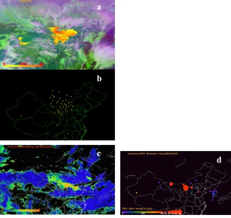
Fig. 5. Validation of FY-2C detection results with ground-based observation. (a) Dust detection results by FY-2C at 06:00 UTC on March 9, 2006. The yellow to red areas overlaying the false FY-2C GRB image are the dust target. The color scale of the areas means IDDI value. (b) shown the dusty stations (yellow points) from GTS weather observation record including Dust in suspend, Blowing Dust and dust storm at the same time as (a) image. (c) shown IDDI image from FY-2C at 04:00 UTC on 28 April 2005. (d) ground-observed PM10 value in China and Korea at the same as (c) image.
ACPD
7, 8395–8421, 2007Operational retrieval of Asian dust from
FY-2C X. Q. Hu et al. Title Page Abstract Introduction Conclusions References Tables Figures ◭ ◮ ◭ ◮ Back Close
Full Screen / Esc
Printer-friendly Version Interactive Discussion EGU 0 2 4 6 8 10 12 14 16 0 5 10 15 20 25 30 35 40
a
IDDI relation to Vis in Hetian, Xinjiang Equation: y = A1*exp(-x/t1) + A0 R^2 0.69667 A0 6.17372 A1 40.18834 t1 2.26902 ID D I (K) Visual Visbility(km) 5 10 15 20 25 30 0 5 10 15 20 25 30 35
b
IDDI relation to Vis in Tazhong, Xinjiang Equation: y = A1*exp(-x/t1) + A0 R^2 0.55784 A0 0.74936 A1 41.53834 t1 10.47988 ID D I (K) Visual Visibility(km) Fig. 6. SDS-IDDI relate to visibility from synoptic visibility data.
ACPD
7, 8395–8421, 2007Operational retrieval of Asian dust from
FY-2C X. Q. Hu et al. Title Page Abstract Introduction Conclusions References Tables Figures ◭ ◮ ◭ ◮ Back Close
Full Screen / Esc
Printer-friendly Version Interactive Discussion EGU 0 5 10 15 20 25 0.0 0.5 1.0 1.5 2.0 2.5 3.0 3.5
a
AO D ( 5 0 0 n m ) IDDI (K) Y = A + B * X Parameter A 0.29454 B 0.10802 R 0.73808 N 18 0 5 10 15 20 25 30 0.0 0.5 1.0 1.5 2.0 2.5 3.0b
AO D (5 5 0 n m) IDDI (K) Y = A + B * X Parameter Value A 0.10879 B 0.12196 R 0.69403 N 66Fig. 7. SDS-IDDI Relate to aerosol optical depth from AERONET at (a) Dunhuang, 2001 and (b) from CE318 Sunphotometer Network in North China.
ACPD
7, 8395–8421, 2007Operational retrieval of Asian dust from
FY-2C X. Q. Hu et al. Title Page Abstract Introduction Conclusions References Tables Figures ◭ ◮ ◭ ◮ Back Close
Full Screen / Esc
Printer-friendly Version Interactive Discussion EGU
a
b
c
d
ACPD
7, 8395–8421, 2007Operational retrieval of Asian dust from
FY-2C X. Q. Hu et al. Title Page Abstract Introduction Conclusions References Tables Figures ◭ ◮ ◭ ◮ Back Close
Full Screen / Esc
Printer-friendly Version Interactive Discussion
EGU