Department of Geosciences, Geography
University of Fribourg (Switzerland)
The evolution of mountain permafrost in the context of
climate change – towards a comprehensive analysis of
permafrost monitoring data from the Swiss Alps
THESIS
Presented to the Faculty of Science of the University of Fribourg (Switzerland)
in consideration for the award of the academic grade of Doctor rerum natruralium
by
Benno Staub
from
Wohlen BE, Switzerland
Thesis No: 1949
UNIprint
Summary
In the Swiss Alps, permafrost occurs discontinuously and commonly has a temperature close to 0 °C. A reduction of Alpine permafrost area and volume is expected in the course of atmospheric warming, but to date, limited evidence is available for Alpine permafrost degradation. Permafrost warming or thaw is accompanied by structural changes in the subsurface, which endanger infrastructure by increasing kinematic activity or slope instability. Changes in the permafrost impact sediment transport to the valley bottom as well as gravitational natural hazards such as rock falls, landslides or debris flows. For these reasons, the quantitative analysis of past and potential future changes in the Alpine permafrost is of great interest and importance.
The objective of this PhD project was to investigate observational data from the Swiss Permafrost Monitoring Network PERMOS using an interdisciplinary approach and to develop new methods for the homogenisation and quantitative analysis of long-term monitoring data. The main focus was on assessing changes in the energy fluxes at the ground surface as a function of the snow cover, as well as on evaluating permafrost response to different meteorological conditions and events. This PhD project was part of the research project The Evolution of Mountain Permafrost in Switzerland (TEMPS, 2011-2015), which used combined observational and model-based approaches and aimed at improving the consistency and completeness of permafrost monitoring data. One achievement of this PhD thesis consists of the development of data processing algorithms for filling data gaps in temperature time series and the quantification of resulting uncertainties. Moreover, algorithms for the approximation of the thermal insulation effect of the snow cover based on ground surface temperature (GST) data were developed. This was of particular importance because snow information is usually not available for the points of interest. Furthermore, possibilities for estimating temperature variations at depth based on GST data were evaluated. The information obtained about the propagation of the thermal signal into the ground led to new insights into the temperature dependency of rock glacier creep, which were supported by observational data.
Data from more than 20 study sites were made comparable in order to quantify differences at the site- and the regional scale. The GST variability proved to be almost as high at the site scale as at the regional scale. This was explained by heterogeneous topo-climatic conditions as well as by the variable snow cover in the geographic context of the Swiss Alps. The roughness of the terrain played a key role, since it modifies the thermal insulation effect of the snow. Coarse-blocky terrains require more snow to be thermally insulated from the atmosphere and freeze more rapidly compared to smooth ground surfaces. The seasonal GST pattern showed that differences among sites and years were large in early winter, whereas GST were less variable in the summer season. Many locations showed similar snow conditions and therefore similar seasonal and inter-annual GST variations, which could not be explained by variations in air temperature. Although no overall increase in GST was found, the data indicate persistent warm conditions at the ground surface since 2009.
Ground temperatures (GT) experienced an overall warming trend down to several tens of m depth over the past 10-25 years. This warming was most distinct in relatively cold permafrost with temperatures below -1 °C. Since the GT at depths between 10-30 m influences the kinematic activity of rock glaciers, the surface deformation rates of the majority of the observed rock glaciers reached maxima between 2013 and 2015. Surface deformation rates quantified by photogrammetry for selected rock glaciers showed an increase in the order of 200-600 % compared to 1990-1995 and 400-800 % compared to 1960-1980.
Long-lasting warm conditions at the ground surface were identified to be the cause of the rise in ground temperature and the increased kinematic activity of rock glaciers. Compared with air temperature, where direct effect on the ground is limited to the snow-free period, the snow cover and its onset in early winter had a much greater influence on the heat and energy exchange at the ground surface. After one or two snow-poor winters, permafrost was able to regenerate thermally. Strong ground cooling occurred between 2005 and 2007, which caused a temporary trend reversal in the warming ground temperatures, limiting the effect of the particularly warm air temperatures between June 2006 and May 2007. Since Alpine permafrost is not in equilibrium with the current climatic conditions, recovery periods of efficient winter cooling will probably play a key role for its future evolution and preservation.
Overall, the results of this PhD project contribute to an improved process understanding and put observed ground thermal and kinematic phenomena in the context of past and potential future changes of permafrost in the Swiss Alps.
Zusammenfassung
Im Schweizer Alpenraum kommt Permafrost nur diskontinuierlich vor und ist mehrheitlich nahe an 0 °C. Im Zuge der bisherigen und noch bevorstehenden Klimaerwärmung ist sowohl eine flächenmässige als auch volumetrische Abnahme des alpinen Permafrost wahrscheinlich, was jedoch nur punktuell mit Messdaten belegt ist. Mit der Erwärmung und dem Auftauen von Permafrost gehen auch Strukturänderungen im Untergrund einher, welche durch zunehmende Bewegungsaktivität oder Instabilitäten Infrastruktur gefährden können. Veränderungen im Permafrost können sich auch auf den Sedimenttransport bis zum Talgrund sowie auf gravitative Naturgefahrenprozesse wie Felsstürze, Rutschungen oder Murgänge auswirken. Aus all diesen Gründen besteht ein grosses Interesse an einer quantitativen Analyse bisheriger sowie möglicher zukünftiger Veränderungen im alpinen Permafrost.
Das Hauptziel dieses Dissertationsprojekts war die gesamtheitliche und interdisziplinäre Analyse von Permafrost-Messdaten, welche im Rahmen des Schweizer Permafrost Monitoring Netzwerks PERMOS zusammengetragen wurden. Im Zentrum stand die Erforschung von Veränderungen der Energieflüsse an der Bodenoberfläche in Abhängigkeit von der Schneedecke sowie der Reaktion des Permafrost auf verschiedene Witterungsbedingungen. Das Forschungsprojekt The Evolution of Mountain Permafrost in Switzerland (TEMPS, 2011-2015), in wessen Rahmen diese Dissertation entstand, wandte einen kombinierten, sowohl auf Beobachtungen als auch Modell-basierten Forschungsansatz an zur Verbesserung der Konsistenz und Vollständigkeit von Permafrost-Messdaten. Hierzu hat diese Dissertation neue Algorithmen entwickelt um Datenlücken in Temperaturmessreihen zu füllen und daraus resultierende Unsicherheiten zu quantifizieren. Auch die thermische Isolationswirkung der Schneedecke wurde basierend auf Bodenoberflächentemperaturen (engl. Abk. „GST“) approximiert und in der Form von Zeitreihen nutzbar gemacht. Dies war von besonderer Bedeutung, weil Schneedaten für die Permafrost Messstandorte zumeist nicht verfügbar sind. Zudem wurden Möglichkeiten erprobt, um Temperaturänderungen in der Tiefe basierend auf GST-Daten zu simulieren. Mit den dabei gewonnen Erkenntnissen konnte die Temperatur-abhängigkeit von Blockgletscherbewegungen mit Messdaten belegt werden.
Um lokale und regionale Unterschiede verschiedener Permafrost-Messgrössen zu quantifizieren, wurden Daten von über 20 Standorten miteinander vergleichbar gemacht. Dabei stellte sich heraus, dass thermische Charakteristika der Bodenoberfläche kleinräumig fast ebenso variabel sind wie im regionalen Vergleich. Im geographischen Kontext des Schweizer Alpenraums lässt sich dies primär durch heterogene topo-klimatische Bedingungen sowie die hohe räumlich-zeitliche Dynamik der Schneedecke erklären. Dabei spielt die Rauigkeit der Geländeoberfläche eine entscheidende Rolle, weil sie den thermischen Isolationseffekt der Schneedecke modifiziert. Insbesondere grob-blockige Oberflächen bedürfen grösserer Schneemengen zur thermischen Isolation gegenüber der Atmosphäre und kühlen deshalb im Frühwinter wesentlich besser aus als feinkörnige oder glatte Oberflächen. Der saisonale Verlauf der GST zeigt, dass im Frühwinter die Unterschiede der GST sowohl zwischen verschiedenen Standorten als auch im Vergleich verschiedener Jahre wesentlich
grösser sind als während der Auftauphase im Sommer. Viele Standorte mit vergleichbaren Schneeeigenschaften zeigen sehr ähnliche saisonale und jährliche Veränderungen der GST, welche sich nicht mit Veränderungen der Lufttemperatur erklären lassen. Obwohl die GST keinen langfristigen Temperaturanstieg zeigen, herrschen an der Bodenoberfläche seit 2009 anhaltend warme Bedingungen.
Messungen von Bodentemperaturen (engl. Abk. „GT“) zeigten für die vergangenen 10-25 Jahre insgesamt eine Erwärmung bis in grössere Tiefen. Am deutlichsten war diese Erwärmung an kühlen Standorten mit Temperaturen < -1 °C. Die Erwärmung im Untergrund in 10-30 m Tiefe beeinflusst zudem die Bewegungsaktivität von Blockgletschern. Die Mehrheit der beobachteten Blockgletscher erreichte zwischen 2013 und 2015 ein neues Maximum der dokumentierten Bewegungsaktivität. Photogrammetrische Analysen für ausgewählte Blockgletscher zeigen eine Zunahme der Oberflächenbewegungen in der Grössenordnung von 200-600 % gegenüber 1990-1995, resp. 400-800 % gegenüber 1960-1980.
Die Ursache ansteigender Bodentemperaturen in der Tiefe sowie der erhöhten Bewegungsaktivität von Blockgletschern sind langandauernd warme Bedingungen an der Bodenoberfläche. Im Vergleich zur Lufttemperatur, wessen direkter Einfluss sich auf die schneefreien Sommermonate begrenzt, hat die Schneedecke und insbesondere deren Aufbau im Frühwinter den grösseren Effekt auf den Energieaustausch zwischen Boden und Atmosphäre. Thermisch kann sich Permafrost nach einem oder mehreren kalten Wintern mit wenig Schnee rasch regenerieren, v.a. solange der Wassergehalt des Untergrunds gering ist. Dies haben die kühlen Winter zwischen 2005 und 2007 eindrücklich gezeigt, welche z.B. den Einfluss der ausserordentlich warmen Lufttemperaturen zwischen Juni 2006 und May 2007 auf den Permafrost begrenzt haben. Gerade weil der alpine Permafrost mit dem heutigen Klima im Ungleichgewicht steht, dürften solche Regenerationsphasen für dessen langfristigen Erhalt eine zentrale Rolle spielen.
Insgesamt trägt diese Dissertation zu einem verbesserten Prozessverständnis bei und stellt beobachtete thermische und kinematische Phänomene in einen grösseren Zusammenhang zu früheren sowie gegenüber möglichen zukünftigen Veränderungen des alpinen Permafrosts.
Acknowledgements
This thesis would not have been possible without the priceless work of many contributors to PERMOS, who probably spent thousands of hours in the field and in front of computers to provide the collected and partly pre-processed data and meta data. This engagement for the long-term observation of permafrost is driven by passion for the high-mountain areas, the interest in visible and measurable environmental changes and it involves a lot of personal investigation – a precious commitment to the challenging task of maintaining systematic and long-term observations in the harsh high-alpine terrain. In this connection I am very grateful for the immense support and confidence I received from my present and former supervisors and colleagues at the Universities of Fribourg and Berne.
Hans Kienholz, Bernhard Krummenacher and Dragan Vogel provided the perfect framework for innovative permafrost research at the Gemmi site and they supported and encouraged me to become part of the Swiss permafrost monitoring community already as an under-graduate student. Especially I would like to thank to Anina Chiapolini, the members of the Förderverein ProGemmi and the numerous volunteers who assisted in doing the field work in the “Furggentälti”. Without the possibility of being part of the PERMOS network since more than 10 years, I would probably not have focussed on graduating in this domain of research.
Furthermore I would like to thank to all the collaborators within the TEMPS project for their engagement in joint research work and advice on this fascinating but challenging PhD topic. First of all my gratitude goes to Reynald Delaloye for sharing his vast experience in the domain of observational permafrost research and mountain geomorphology and for trusting and encouraging me in the course of the TEMPS project. I was always impressed by his powers of recall regarding the meteorological conditions in the high-mountain areas of Switzerland for the past two decades (at daily to weekly precision!). Reynald clearly sparked my enthusiasm for exploring these large sets of data for thermal and kinematic phenomena.
As each PhD thesis has its ups and downs, I am particularly grateful for all the scientific but also the technical and moral support I received from my colleagues in Fribourg. I appreciated the enjoyable working atmosphere at the University of Fribourg and would like to thank the entire Geography unit, too numerous to mention everyone, for sharing the office and coffee breaks or doing joint field work. I am really looking forward keeping a foot in the door of this friendly, interdisciplinary and multi-cultural research institute also in future.
Moreover I would like to thank Jeannette Noetzli, Christin Hilbich, Andreas Hasler, Antoine Marmy, Christian Hauck, Martin Hoelzle, Ingo Völksch and Christophe Lambiel for their great support in case of any question arose regarding measurements, data processing or metadata. The close connection to the PERMOS project motivated me to put effort in research work which hopefully will find some application also after the TEMPS project will be finished. In this context I would like to specially thank to all TEMPS subprojects for providing data, shearing ideas and for the scientific and personal
exchange at conferences and meetings. The research work done in the frame of this thesis significantly benefited from large sets of snow data provided by SLF, reconstructed meteorological data provided by ETH as well as meteorological data from MeteoSwiss.
Special thanks go to Antoni Lewkowicz, Marcia Phillips and Xavier Bodin for having examined this PhD thesis as experts. I appreciate the fruitful discussions and your very constructive and detailed comments on my research work.
Last but certainly not least I would like to thank to my family and to Sabine for always supporting and encouraging me when needed.
This dissertation was financed by a grant from the Swiss National Science Foundation (project CRSII2_136279, 2011-2015) entitled «The Evolution of Mountain Permafrost in Switzerland» (TEMPS).
Table of contents
Summary ... i
Zusammenfassung ... iii
Acknowledgements ... v
Table of contents ... vii
Figures and tables ... xi
List of abbreviations ... xv
PART I:OVERVIEW... 1
1 Mountain permafrost in the context of climate change ... 3
1.1 Permafrost definition and relevance of mountain permafrost ... 3
1.2 The evolution of Alpine permafrost with regard to climate change ... 3
1.3 Open questions in mountain permafrost research and monitoring ... 6
1.4 Research objectives and questions ... 6
1.5 Outline of the thesis ... 8
2 Scientific background on mountain permafrost ... 9
2.1 Mountain permafrost in the Swiss Alps ... 9
2.1.1 Spatial permafrost distribution and direct permafrost observations ... 9
2.1.2 Heterogeneity of the mountainous terrain and snow cover ... 12
2.1.3 Characteristics of periglacial landforms ... 13
2.2 Properties and processes influencing the ground thermal regime ... 16
2.2.1 Heat and energy exchange at the ground surface ... 16
2.2.2 Influence of the snow cover on the surface energy balance ... 17
2.2.3 Heat and energy exchange as a function of subsurface characteristics ... 21
2.2.4 Characteristics of coarse-blocky and ice-rich substrates ... 23
2.3 Mechanics of frozen ground materials and ice ... 24
PART II:DATA AND METHODS ... 27
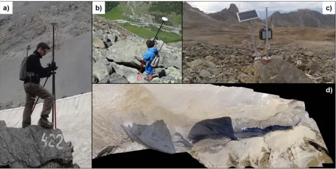
3 Permafrost monitoring data ... 29
3.1 Permafrost monitoring sites ... 29
3.2.1 Ground surface temperatures (GST) ... 31
3.2.2 Ground temperatures (GT) ... 33
3.3 Micrometeorological measurements ... 34
3.4 Kinematic measurements ... 36
3.5 Geophysical measurements ... 37
4 Processing of observational mountain permafrost data ... 41
4.1 Processing and homogenization of raw data ... 41
4.1.1 Ground temperature (GT) and ground surface temperature (GST) data ... 41
4.1.2 Meteorological data ... 45
4.1.3 Kinematic data ... 45
4.1.4 Geophysical data ... 47
4.2 Reconstruction of missing data and quantification of uncertainties ... 48
4.2.1 Comparison of approaches ... 48
4.2.2 Uncertainty assessment and error propagation ... 49
4.2.3 Procedures for filling gaps in thermal data ... 49
4.2.4 Procedures for meteorological data... 52
4.2.5 Procedures for kinematic data ... 56
5 Integrative analysis of permafrost monitoring data ... 59
5.1 Addressing different scales in time and space with aggregates and indices ... 59
5.2 Deriving snow information based on GST data ... 62
5.2.1 Generalities and GST-derived snow information ... 62
5.2.2 Use and limitations of the methods ... 64
5.2.3 Potential improvements of the melt-index by considering global radiation ... 65
5.3 Quantification of the time lag between GST and GT at depth ... 65
5.4 Visualization of the degree of conductivity with thermal orbits ... 67
5.5 Approximation of GT variations from GST data for analysing rock glacier kinematics ... 69
PART III:RESULTS ... 73
6 Evolution and variability of mountain permafrost parameters ... 75
6.1 Meteorological and snow data ... 75
6.2 Temporal evolution and variations observed in ground temperature data ... 77
6.3 Evolution of rock glacier creep activity ... 81
6.4 Temporal and spatial variability of electrical resistivity ... 82
6.5 Spatial variability of permafrost-relevant topo-climatic parameters ... 84
6.6 Concluding remarks ... 85
7 Thermal and kinematic response to meteorological events ... 87
7.1 Important meteorological events between 2000 and 2015 ... 87
7.2 Thermal response ... 90
7.2.1 Response time and persistence of meteorological events ... 90
7.2.2 Relative importance of air temperature and snow on the surface energy balance ... 94
7.2.3 Reversibility of GST and GT in function of the snow thermal insulation ... 95
7.3 Kinematic response ... 97
7.3.1 Inter-annual variations of rock glacier velocities in reaction to GT variations ... 97
7.3.2 Relative importance of ground temperature and melt water infiltration ... 101
7.4 Concluding remarks ... 103
PART IV:SYNTHESIS ... 105
8 General discussion ... 107
8.1 Techniques for data homogenization, gap filling and integrative analysis ... 107
8.1.1 Gap filling of thermal, meteorological and kinematic data ... 107
8.1.2 Indices describing the snow thermal insulation and snow melt rate ... 109
8.1.3 Temperature time lags between the surface and different depths ... 110
8.1.4 Approximation of temperature variations at depth based on GST time series ... 111
8.2 Influence of meteorological events and snow conditions on ground temperatures ... 111
8.3 Permafrost creep in response to ground temperature variations ... 114
8.4 Evaluation of the permafrost monitoring strategy of PERMOS ... 117
9 Conclusions and perspectives ... 119
9.1 Main findings ... 119
9.1.2 The evolution of mountain permafrost in Switzerland since 2000 ... 120
9.1.3 Recommendations for the mountain permafrost monitoring in the Swiss Alps ... 122
9.2 Perspectives and future research needs ... 123
References ... 125
PART V:JOURNAL PUBLICATIONS ... 139
Publication I ... 141
Publication II ... 161
Publication III ... 179
APPENDIX ... 199
Figures and tables
Fig. 1.1: Evolution of air temperatures in the Swiss Alps between 1864 and 2014 4 Fig. 1.2: Evolution of air and ground temperature at Murtèl-Corvatsch 5 Fig. 2.1: The potential permafrost occurrence in the Swiss Alps based on the APIM index 10 Fig. 2.2: Examples of direct observation of ground ice and permafrost 11 Fig. 2.3: The heterogeneity of terrain roughness and snow coverage in mountainous terrain 12 Fig. 2.4: Temporal evolution and spatial variability of snow depth on a rock glacier 13 Fig. 2.5: Overview of periglacial landforms typical for the mountain permafrost domain 15 Fig. 2.6: Heat and energy exchange at the ground surface over permafrost 17 Fig. 2.7: Influence of snow on GST at the example of the Gemmi rock glacier 18 Fig. 2.8: Convective air circulation within coarse-blocky material 23
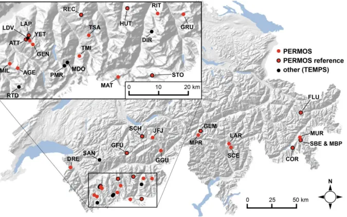
Fig. 3.1: Permafrost monitoring sites in the Swiss Alps 30
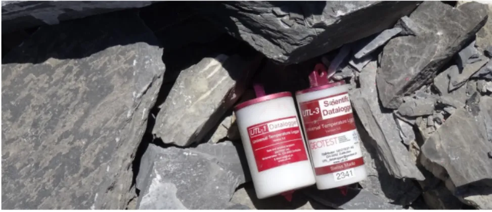
Fig. 3.2: Miniature data loggers for measuring GST continuously 31 Fig. 3.3: Completeness and gap characteristics of the PERMOS & TEMPS GST monitoring data 32 Fig. 3.4: Field impressions from borehole drilling and thermistor calibration 33
Fig. 3.5: Overview of the PERMOS ground temperature data 34
Fig. 3.6: Weather stations at the monitoring site Gemmi/Furggentälti 35 Fig. 3.7: Measuring displacement rates and surface changes on rock glaciers 37 Fig. 3.8: Application of geophysical methods for mountain permafrost monitoring 38 Fig. 3.9: Field impressions from ERT monitoring at the Réchy site 39 Fig. 4.1: Theoretical aspects on the accuracy and precision of data 41
Fig. 4.2: Zero curtain correction of GST time series 42
Fig. 4.3: Correction of GT data measured in the LAP_0198 borehole 43 Fig. 4.4: Influence of the precision of UTL-1 thermistors on the measured time series 44 Fig. 4.5: Correction of coordinates measured by DGPS from two surveying campaigns 46
Fig. 4.6: GST gap filling by linear interpolation 50
Fig. 4.8: Two-step bias correction approach for meteorological parameters 53 Fig. 4.9: Seasonal pattern of air temperature lapse rates in high-alpine terrain 54 Fig. 4.10: Comparison of grid-derived air temperature with station observations 54 Fig. 4.11: Approximation of the incoming shortwave solar radiation 55 Fig. 4.12: Gap filling of kinematic data and estimation of uncertainties 57 Fig. 5.1: GST aggregates and indices for the integrative analysis of the surface energy balance 60 Fig. 5.2: BTS, WeQT and LWST values derived from daily mean GST data 61 Fig. 5.3: Seasonal patterns of AirT and GST measured on a rock glacier at “Alpage de Mille” 63 Fig. 5.4: Comparison of GST and snow indices for selected GST time series 64 Fig. 5.5: Time lag of the GST signal at different depths in borehole COR_0278 66 Fig. 5.6: Thermal orbits for the visualization of heat conduction between GT time series 68 Fig. 5.7: Approximation of GT variations at depth using GST data 70 Fig. 5.8: Image correlation for the extraction of displacement vectors from orthophotos 72 Fig. 6.1: Evolution of air temperature and snow depth at permafrost monitoring sites 76 Fig. 6.2: Evolution of GST aggregates and indices between 1998 and 2014 77 Fig. 6.3: Spatial variability of permafrost-relevant indices and aggregates 78
Fig. 6.4: Evolution of GT at selected PERMOS boreholes 80
Fig. 6.5: Evolution of GT around the zero annual amplitude (ZAA) 80 Fig. 6.6: Photogrammetric reconstruction of horizontal rock glacier creep velocities since 1960 81 Fig. 6.7: Evolution of horizontal surface velocities on selected rock glaciers 82 Fig. 6.8: The seasonal pattern of mean apparent electrical resistivity measured at the Schilthorn 83 Fig. 6.9: Evolution of apparent electrical resistivites compared with ground temperatures 84 Fig. 6.10: Representativeness of GST and GT observations regarding topo-climatic characteristics 85 Fig. 7.1: Influence of meteorological events on the ground thermal regime 88 Fig. 7.2: Comparison of MAGST and MAGST changes compared with other GST indices 90 Fig. 7.3: The ground thermal response on early and late onset of the insulating snow cover 91 Fig. 7.4: Ground thermal effect of the snow melt illustrated with data from the Schilthorn 92 Fig. 7.5: Time lags of the GST signal at depth, analysed for all PERMOS/TEMPS boreholes 93
Fig. 7.6: Influence of the snow onset on ground freezing 94 Fig. 7.7: Influence of snow disappearance, AirT and ISR on the ground thawing 95 Fig. 7.8: Cumulative GST degree days (CDD) compared for different years and loggers 96 Fig. 7.9: Relationship between variations in GST and horizontal surface velocities of rock glaciers 98 Fig. 7.10: Density distribution of filter windows and time lags for GTsynt at five rock glaciers 99 Fig. 7.11: The thermo-mechanical movement behaviour of rock glaciers: obtained parameters 100 Fig. 7.12: Comparison of the temperature-velocity relationship of selected rock glaciers 101 Fig. 7.13: Inter-annual variations of rock glacier creep velocity residuals 102 Fig. 7.14: Seasonal variations of rock glacier creep velocities compared with snow melt rates 103
List of abbreviations
AirT Air temperature (°C), usually recorded ~2 m above ground
ALT Thickness of the active layer (m), surface layer in which water thaws and freezes annually DEM Digital elevation model
BTS Basal temperature of the Snow cover (°C)
CCD Cumulative degree days (e.g. sum of daily mean temperatures) ERT Electrical resistivity tomography (geophysical method)
FDD Freezing degree days, temperature-index summarizing negative daily mean values GST Ground surface temperature (°C), usually measured ~5-20 cm below the surface GT Ground temperature (°C) measured in the substrate, e.g. in boreholes
GTsynt Synthetic GT variations approximated by GST time series (Sect. 5.5)
HTIstart Start of the period of high thermal insulation by snow (date or day of the year) Hyear Hydrological year (October 1 to September 30), e.g. 2014 for the period 2013/2014 ISR Incoming shortwave radiation (Wm-2)
LI Linear interpolation LR Linear regression
LWST Late winter surface temperature (°C, Sect. 5.1) MAAR Mean annual apparent electrical resistivity (Ωm) MAAT Mean annual air temperature (°C)
MAGST Mean annual ground surface temperature (°C) MAGT Mean annual ground temperature (°C)
PERMOS Swiss Permafrost Monitoring Network
PISR Potential ISR (Wm-2) for clear sky conditions, computed using GIS software QM Quantile mapping (method used for bias correction and spatial transfer of data) RD Basal ripening date of the snow cover, start of the snow melt (date or day of the year) RMSE Root mean square error
RST Refraction seismic tomography (geophysical method) SD Standard deviation
SDD Snow disappearance date (date or day of the year) SOD Snow onset date (date or day of the year)
SO Surface offset, namely GST-AirT (K) SWE Snow water equivalent (mm)
TEMPS SNSF project (2011-2015) on “The evolution of mountain permafrost in Switzerland” TDD Thawing degree days, temperature-index summarizing positive daily mean values TO Thermal offset, namely GT-GST (K)
ZAA Zero annual amplitude, depth below the ground surface (m) ZC Zero curtain (period of phase changes, detected in GST or GT data) WEqT Winter equilibrium temperature (°C)
1 Mountain permafrost in the context of climate change
1.1 Permafrost definition and relevance of mountain permafrost
Permafrost is a subsurface phenomenon usually not visible from the surface. It is defined as ground material remaining at temperatures below or at 0 °C for two or more consecutive years (Williams and Smith, 1989). The respective ground material may – but does not necessarily need to – contain ice. Since hydro-thermo-mechanical processes as well as the energy and heat-exchange towards the atmosphere substantially differ from unfrozen substrate and from glacier ice, permafrost has its own research discipline within the cryospheric sciences.
In periods of transition to a warmer climate, changes in permafrost temperatures as well as other ground properties, such as the content of organic matter, the portion of ground ice and water or its kinematic behaviour, become particularly important (Lawrence and Slater, 2005). Permafrost thaw endangers entire ecosystems and the global climate by potentially significant emissions of carbon dioxide and methane (Anisimov, 2007; Anthony et al., 2012; Schuur et al., 2008). At high-latitudes, major concerns are related to the construction and maintenance of infrastructure as well as severe modifications of the morphology and hydrology (e.g. by costal erosion or the collapse of thermocarst). In arid and semi-arid areas such as the central Asian mountains or the Andes, permafrost landforms (e.g. rock glaciers, push moraines or talus slopes) may be or become relevant for the water supply of entire river systems (Rangecroft et al., 2013). Changes in high-mountain
permafrost in steep terrains can influence the frequency and magnitude of gravitational natural
hazards with consequences at the local and regional scale (Deline et al., 2015).
In Switzerland the permafrost occurrence is discontinuous and confined to the highest elevation bands of the Alps (Sect. 2.1.1). In the light of permafrost degradation, stability issues in steep terrain and mass movements of rock and debris are directly or indirectly affecting infrastructure. The bonding of fractured hillslope materials by interstitial ice and the creep of ice-saturated sediments are known to be temperature-dependant and prone to changes with proceeding permafrost warming or thaw (Davies et al., 2001; Gruber and Haeberli, 2007; Rist and Phillips, 2005). Yet, these processes are still not fully understood (Krautblatter et al., 2012). In this context, the comprehensive analysis of observational data from high-mountain permafrost environments is very promising to improve the process-understanding. The development of new approaches towards a quantitative and integrative
analysis of long-term permafrost monitoring data as well as maximizing the scientific outcome from
existing data are the major scientific aims of this PhD thesis.
1.2 The evolution of Alpine permafrost with regard to climate change
At the global scale air temperature has risen about +0.8 °C during the past 100 years and is still increasing (IPCC, 2013). In the European Alps, the atmospheric warming was even more distinct with a first peak in the late 1940ties and a second, very strong air temperature increase of +1.3 °C between 1975 and 2000 (Auer et al., 2007; Begert et al., 2005). For Switzerland during the period 1961-2013,
air temperatures rose +0.37 °C/decade on an annual basis and +0.5 °C/decade in the summer months June-August, causing an average increase of the zero degree level of about +60 m/decade (MeteoSwiss, 2014). The strong warming around the 1980ties and the ongoing warm conditions are also shown in Fig. 1.1. In spite of large inter-annual variations, 17 of the warmest 20 years since the beginning of the observations in 1864 occurred since 1990 (MeteoSwiss, 2014).
Scenarios for future climate evolution in Europe predict an additional air temperature increase of
2-5 °C (IPCC, 2013) until the end of the 21st century (Fig. 1.2a), with a maximum at high elevations (Kotlarski et al., 2015). This warming will very probably be accompanied by changes in the seasonal cycle of precipitation, snow coverage and global radiation as well as a higher frequency of weather
extremes (CH2011, 2011; Gobiet et al., 2014; Steger et al., 2012). Hot periods like the heat waves in
summer 2003 are likely to occur every second year towards the end of the century (Gobiet et al., 2014). The strongest air temperature rise is expected for the summer season, which may lead to earlier and more intense snow melt as well as warmer and drier ground conditions (CH2011, 2011). Concerning precipitation, the predictions on annual and seasonal changes are less clear: similar or even slightly larger amounts of precipitation between December and May and drier conditions between June and August are most probable (CH2011, 2011). However, precipitation extremes are very likely to occur more frequently, particularly in autumn (Rajczak et al., 2013). Studies from Morán-Tejeda et al. (2013) and Schmucki et al. (2014) indicate that future snow evolution at high elevation might depend on the evolution of precipitation rather than on temperature. This implies that very early as well as very late thermal insulation of the ground by the snow cover may still occur in the future.
Fig. 1.1: Evolution of air temperatures in the high-alpine domain of the Swiss Alps between 1984 and 2014, measured at 2500 m asl at the Säntis mountain peak the north-east of the Swiss Alps (source: MeteoSwiss): The black curve shows the 10-year running average of homogenized air temperature anomalies relative to the mean of all observations. The outline of the coloured area represents running annual means of the same data with positive and negative temperature anomalies. For comparison, rock glacier surface displacement rates (m/year) observed at the Gemmi rock glacier in the northern Swiss Alps are illustrated with the purple lines (dotted line: photogrammetric reconstruction based on aerial images; thick line: annual terrestrial surveys). The Swiss Permafrost Monitoring Network PERMOS is operational since 2000.
Compared to 1990, about 45 % of the area and 50 % of the volume of the Alpine glaciers will be melted towards the end of the 21st century (Huss, 2012). This drastic reduction of glaciated and snow covered areas will decrease the surface albedo and act as a positive feedback mechanism increasing air and ground temperatures even more. Although permafrost is covered with sediment or rock and is thus – contrary to glaciers – not as directly influenced by air temperature, the changing climatic
Section 1.2: The evolution of Alpine permafrost with regard to climate change Mountain permafrost is mainly characterized by rough terrain in complex topography with spatially variable micro-climatic conditions and ground properties (Sect. 2.1 and 2.2). The energy and heat transfer between the ground and the atmosphere is strongly modified by the timing and thickness of the snow cover and the properties of the surface and subsurface (e.g. terrain roughness, porosity, water and ice content, thermal conductivity of the material). Despite the existence of generally snow-free locations such as oversteepened rock walls, where surface temperatures are highly correlated to air temperature and radiation, air temperature is not an adequate proxy for the
evolution of the ground thermal regime over the course of years or decades. Ground surface
temperatures (so-called GST, measured ~5-20 cm below the surface) are more representative because they constitute a filtered integral of the surface energy balance (Sect. 2.2), including the effects of the snow cover (thermal insulation and modified radiation balance). With increasing depth, the temperature signal from the surface gets buffered and delayed. Therefore, ground temperatures (GT) recorded in boreholes at >10-20 m depth can be used as an indicator for variations of the surface energy balance at the decadal scale (Fig. 1.1). The spatio-temporal variability of ground and
ground surface temperatures is a key for understanding the processes that act today and were
relevant in the past, and from this, the basis to learn more about the future permafrost evolution. Observations are the link between the real world and its representation in models (Fig. 1.2b).
Fig. 1.2: Evolution of air and ground temperature at the Murtèl-Corvatsch rock glacier (Upper Engadine): a) shows in black the mean annual air temperature from downscaled and bias-corrected reanalysis data (Rajczak et al., 2015) and in red the corresponding climate projection for the same station (ensemble mean of 14 Regional Climate Models (RCM) and on the basis of the IPCC A1B emission scenario); b) shows ground temperatures (GT) measured at 10 m depth in borehole COR_0287 and simulation results based on the climate projections for the same depth (Marmy et al., 2015). Because mountain permafrost research is a young discipline, the first measurements in the Swiss Alps started in the late 1980ties. Hence, the most striking increase in air temperature is only indirectly documented in the delayed ground temperature increase (Fig. 1.2) recorded in the oldest borehole from rock glacier Murtèl-Corvatsch, drilled in 1987 (Haeberli et al., 1988). Based on ground temperature measurements from a handful of deep boreholes in the European Alps, Harris et al. (2003) have shown that permafrost has warmed in the order of +0.5-0.8 °C within the uppermost
tens of meters substrate during the 20th century. Even though ground truth data from boreholes drilled in Alpine permafrost only exists for a few points, the Swiss Permafrost Monitoring Network (PERMOS) nowadays comprises large sets of thermal (mainly GST), meteorological, kinematic, as well as geophysical, observations. However, very diverse topographic situations and subsurface properties as well as various technical issues and data gaps complicate a coherent analysis.
1.3 Open questions in mountain permafrost research and monitoring
Many questions still remain open in the field of mountain permafrost research, particularly regarding the processes which dominate the evolution of the ground thermal regime and their influence on terrain movements and slope stability. Distinct morphological changes and an increasing activity (Fig. 1.1) observed for a multitude of rock glaciers (Delaloye et al., 2010, 2013; Roer et al., 2008) raise questions about potential destabilization and systemic changes of creeping landforms in the context of climate change. Therefore, the influence of subsurface properties (such as the ice and water content) on the thermal and kinematic response of permafrost to meteorological events and different snow conditions are being intensively investigated at present. In summary, a particular scientific interest is devoted to the consequences of potential permafrost warming and degradation and which regions, substrates or landforms will most likely undergo changes in the near future. A comprehensive analysis of permafrost observations is a prerequisite for answering these questions. Also the permafrost modelling community has a great need for high-quality observational data and the assessment of the model performance during the calibration period would be an ideal point of contact for collaboration between the modellers and those who collect and study field data.
Regarding permafrost monitoring, the current monitoring setup deserves careful revision. Many measurements evolved historically because of the research priorities of the investigating research institutions but have not been scientifically evaluated to be representative for the high-mountain permafrost domain. In this context, the TEMPS project as well as this PhD thesis seeks at contributing to an evaluation and potential improvement of the permafrost monitoring strategy.
1.4 Research objectives and questions
To reach conclusions concerning the recent thermal evolution of different mountain permafrost landforms, a comprehensive analysis of temperature time series from many different field sites and comparison with additional data such as surface displacement rates of rock glaciers or geophysical measurements are required. In this context, this PhD thesis – which is part of the SNSF Sinergia research project “The Evolution of Mountain Permafrost in Switzerland” (TEMPS, 2011-2015, project no. CRSII2_136279) – aims at developing adequate methods and procedures for combining and
analysing a large set of observations as well as characterizing the state and recent evolution of permafrost properties in the Swiss Alps. It specifically focuses on meteorological events that
influence the thermal regime at the ground surface at the time scales of days to several years, but which are believed to be relevant for the evolution of ground temperatures also at depth and over long-term. Methodically, it ranges between a detailed geomorphological case study and the
Section 1.4: Research objectives and questions statistical analysis of a large data set. Consciously seeking points of contact with the climate and permafrost modelling community, this PhD thesis pursues an inter-disciplinary and process-oriented approach. For reaching the overall aim, the four main objectives are as follows:
Objective A: Quantification of the effects of meteorological conditions and events on ground surface temperatures considering differing topo-climatic situations and ground properties.
A deep knowledge of the thermal evolution and the processes at the ground surface is essential to understand the potential future permafrost evolution. The following research questions were formulated to assess objective A:
1) Meteorological events: Which meteorological events, terrain types and snow properties have the strongest warming or cooling effects on the ground? How can this be shown with long-term monitoring data?
2) Snow effects: How relevant is the snow cover relative to air temperature? How variable is the thermal insulation effect of the snow cover in time and space?
3) GST response: Which effects lead to a delayed or weakened response of GST to increased air temperatures? Which terrain types and landforms are particularly sensitive to meteorological events and what could this imply regarding the sensitivity of mountain permafrost to climate change?
Objective B: Improvement of the understanding of processes influencing the thermal evolution at
depth and the seasonal and inter-annual variations of rock glacier kinematics and permafrost creep based on long-term observations.
Regarding rock glacier kinematics, the ground thermal conditions at depth (i.e. at the “shear horizon”, Sect. 2.3) and the relative importance of temperature variations and melt water infiltration deserve particular attention. This is assessed by the following specific research questions:
1) Ground temperatures: How fast does the temperature signal from the surface propagate into the ground and what are typical time lags at depth?
2) Kinematic response: Do short-term meteorological conditions affect the kinematic behaviour of rock glaciers and what is their relative importance?
3) Destabilisation signs: Are phenomena of permafrost degradation and rock glacier destabilisation detectable (and predictable) from long-term observation?
Objective C: Optimization of the value of scientific information of observational permafrost data,
particularly regarding site-specific terrain and snow characteristics.
To reach objectives A and B with an observational approach, considerable efforts are required for data processing and analysis. Therefore, objective C aims at the development of adequate methods
Alps was used here, these methods will potentially be applicable for mountain permafrost applications also in other regions. Objective C is linked to the following research questions:
1) Homogenization and gap filling: How can data gaps in GST, GT and kinematic data be filled and the resulting uncertainties quantified?
2) Relationship between GST and GT: How and up to what depth can seasonal and inter-annual ground temperature variations be approximated by GST?
3) GST-derived snow characteristics: To what degree can the thermal insulation effect of the snow cover and the snow melt rate be quantified based on GST and air temperature data? 4) Integrative data analysis: Which data sets and methods are best suited to compare
permafrost evolution and its influencing processes among different sites, years and monitoring parameters?
Objective D: Recommendations for mountain permafrost monitoring and climate impact research.
Objective D evaluates needs for action in permafrost monitoring and aims at contributing to an
improved permafrost monitoring strategy. Moreover, key messages on the evolution of mountain permafrost in the Swiss Alps are formulated, which may be of interest to climate impact research or
related fields. The following research questions guide towards achieving objective D:
1) Monitoring setup: Which methods and data sets are particularly important to document changes in mountain permafrost? How could the future mountain permafrost monitoring setup be improved to efficiently cover small-scale variability relating to snow cover dynamics and subsurface properties? Where is there potential for increasing efficiency?
2) Complementary data and meta data: Which additional data sets and meta information are most important or still missing?
3) Permafrost evolution: Which are the most important facts regarding permafrost evolution over the past 2 decades? What does this imply for potential future permafrost evolution?
1.5 Outline of the thesis
This thesis is organised in five parts: following the introduction in chapter 1, chapter 2 presents the scientific background and closes the overview (Part I). In Part II, the data (chapter 3) and methodological approaches of the thesis are described, while chapters 4 and 5 focus on answering the questions in objective C. Part II further summarizes the main scientific outcome of the publications Staub and Delaloye (2016) and Staub et al. (subm.). Within Part III, the results on an integrative data analysis as well as key findings on the mountain permafrost evolution and selected results of publication Staub et al. (2015) are presented. As a synthesis (Part IV), the methodological approach and the obtained results are discussed in chapter 8, which is structured according to the main research objectives. Chapter 9 provides the conclusions and an outlook for future research needs. Journal publications which have been published or prepared for submission in the frame of this PhD project can be found in Part V.
2 Scientific background on mountain permafrost
2.1 Mountain permafrost in the Swiss Alps
Various periglacial landforms and a large variety of topo-climatic conditions need to be taken into account to obtain a representative view of the conditions and the evolution of permafrost in the high-mountain domain of Switzerland. The rough topography and heterogeneous terrain and snow characteristics of high-mountain environments make ground temperatures very variable in time and space. Therefore, mountain permafrost research should address also small spatial scales while considering a wide range of temporal scales (hours – several years).
2.1.1 Spatial permafrost distribution and direct permafrost observations
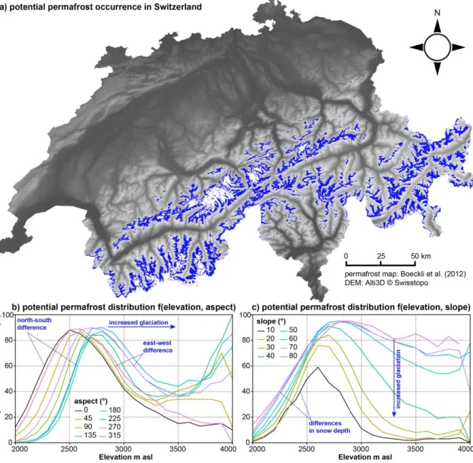
In the Alps, permafrost is covering approximately 5 % of the surface area of Switzerland (Boeckli et al., 2012c; Keller et al., 1998). Permafrost is found particularly in locations with a cold micro-climate at elevations above 2500 m asl that are not covered by thick glaciers (Gruber and Haeberli, 2009; Noetzli and Gruber, 2005). Fig. 2.1 illustrates with data from Boeckli et al. (2012b) that the area fraction of potential permafrost occurrence not covered by glaciers is largest in the elevation band from 2400 to 3000 m asl, with considerable differences as a function of aspect and slope. Due to the increasing area fraction of glaciated surfaces at high elevations, the proportion of permafrost starts to decrease from 2600-2800 m asl upwards. The rock behind hanging glaciers mainly in north-exposed rock faces at very high elevation should technically also be considered to be permafrost (Fig. 2.2a). To reach similar area fractions underlain by permafrost as on north slopes, mountain flanks oriented southwards need to be at 300-400 m higher elevation (Fig. 2.1b), due to the increased global radiation. Rock surface temperatures simulated by Gruber et al. (2004) and Noetzli et al. (2007) indicate maximal north-south differences in the order of 6-7 °C. The difference between east and west could be due to the higher probability of convective clouds in the afternoon (Gubler et al., 2011) or due to prevailing winds from the west causing more snow accumulation on east slopes. Indeed, east-exposed slopes are warmer than west-exposed slopes over the year: differences in mean annual values of 0.8 °C were measured over loose debris by Gubler et al. (2011) and simulations from Noetzli et al. (2007) for steep rock faces revealed 2.5 °C warmer surface temperatures on east slopes. If they are less influenced by snow, steep slopes may be favourable for permafrost occurrence compared to flat or gently inclined terrain (Fig. 2.1c). The differing permafrost area fraction among slopes at high elevation can be explained by the high proportion of glaciated areas in flat and gently inclined terrain. Fig. 2.1 illustrates the high spatial variability of permafrost occurrence as a subsurface phenomenon and its dependency on topo-climatic factors for the Swiss Alps.
Fig. 2.1: The potential permafrost occurrence in the Swiss Alps based on the Alpine Permafrost Index Map (APIM) from Boeckli et al. (2012a, 2012c): a) in blue the maximum permafrost extent excluding glaciated areas (white) on an elevation map of Switzerland (source: Alti3D © Swisstopo); b) and c) show the relative area fractions potentially underlain by permafrost as a function of elevation (m asl), aspect (degrees north) and slope (°).
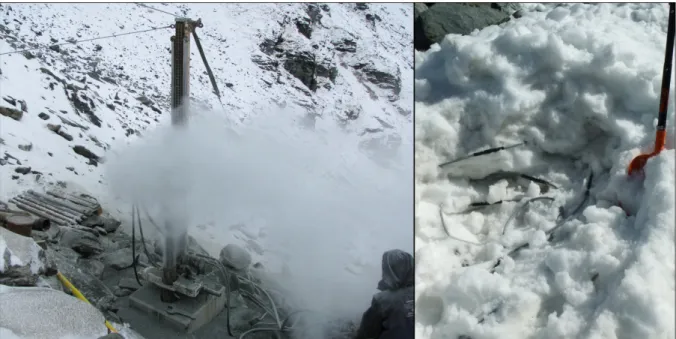
At local scales (e.g. for the planning of borehole locations for research projects or engineering), permafrost is usually mapped by field observations such as BTS measurements (basal temperature of the winter snow cover introduced by Haeberli (1973)), continuous ground surface temperature (GST) measurements (Hoelzle et al., 1999) or geophysical surveys (Hauck, 2013; Scapozza et al., 2010; Vonder Mühll et al., 2002). Single BTS surveys and short GST time series may not be representative due to the large inter-annual and seasonal variability of GST. Repeated observations are required to make sound conclusions about the ground thermal regime, ideally by combining the strengths of several methods (Sect. 3). Because GST may vary in the order of meters (Gubler et al., 2011) the spatial resolution of these methods needs to be adapted to the desired accuracy of the results.
Section 2.1: Mountain permafrost in the Swiss Alps
Direct observations of mountain permafrost are usually limited to very small areas (mostly points) or
rather qualitative information such as inventories of active rock glaciers or rock fall events (Cremonese et al., 2011). Examples of direct observations of permafrost are illustrated in Fig. 2.2. In some cases, ground ice has been directly visible after drilling or excavations in trenches at construction sites or in scars after rock fall events. According to the PERMOS rock fall inventory, prominent recent rock fall events happened in summer 2003 at the Matterhorn (CH), the Eiger (CH), the Aiguille du Midi in the Mont Blanc massif (FR) and were attributed to the exceptionally warm air temperatures at this time (Gruber, 2004). However, many rock fall events remain undocumented, e.g. because they are small or do not directly affect infrastructure. Rock volumes have been quantified only for a small number of events (Ravanel et al., 2010). Furthermore, the cause of rock fall events and the relation to permafrost is often unclear (Hasler, 2011). Yet, alternating cycles of thawing and freezing are supposed to exert mechanical stress in rock fractures (Sect. 2.3).
Fig. 2.2: Examples of direct observation of ground ice and/or permafrost conditions: a) Remnants of a hanging glacier on the north flank of the Fierscherhorn in the Bernese Alps indicate frozen rock; b) typical shape of an active rock glacier with a steep front as indicator of the presence of high ground ice contents; c) massive ice and seeping water in the scar on the Tour des Grandes Jorasses in the Mont Blanc area two weeks after rock fall event 2007 (Ravanel et al., 2010); d) Ground ice found during excavations in 1998 at the Lapires site (Photo: Emmanuel Reynard).
Direct observations provide valuable information about ground properties and ongoing processes. But to draw conclusions about changes and trends, continuous or systematically repeated
2.1.2 Heterogeneity of the mountainous terrain and snow cover
In mountainous regions as the Swiss Alps, topography and snow greatly affect the local climate and the energy balance at the ground surface at different spatial scales. Snow is known to be a key factor
for the surface energy balance of permafrost as well as for the variability of GST over short distances
(Gisnås et al., 2014; Goodrich, 1982; Gubler et al., 2011; Stocker-Mittaz et al., 2002; Vonder Mühll et al., 2001a). The spatial patterns of snow accumulation, re-distribution by wind and avalanches and melt are influenced by the shape and curvature of the terrain. Therefore, topography and terrain
roughness are essential for the ground thermal regime and mountain permafrost evolution at
various scales. Shading by mountain ridges (100 m - 10 km) as well as unique boulders or rock spurs (~1-10 m) affect wind and radiation. These effects are illustrated in Fig. 2.3.
Fig. 2.3: Illustration of the heterogeneity of terrain roughness and snow coverage: At many different spatial scales, topography and terrain roughness influence the topo-climatic conditions, snow coverage and related processes of heat and energy exchange at the ground surface. The photograph was taken in October 2011 on Gornergrat (Zermatt, VS).
The effect of topography on the radiation balance remains constant over years, but snow cover is prone to large seasonal- and inter-annual variations in dependence on the frequency and amplitude of precipitation. The snow cover underlies changing spatial patterns depending mainly on the prevailing wind direction and avalanche activity. Fig. 2.4 illustrates that snow data from one point may not be representative for an entire landform. Moreover, the micro-roughness of the terrain greatly modifies the thermal insulation effect of the snow, so that energy fluxes through the snow cover may be higher around obstacles such as rocks or spurs compared to flat or regular terrain. Therefore, permafrost observations like GST are mainly representative for the specific
measurement location. Hence, large amounts of data covering several years and various terrain
characteristics are required to draw sound conclusions regarding permafrost evolution. For permafrost modelling this implies that an accurate description of the ground thermal regime is only possible for sites with excellent observational data and by considering a realistic snow cover for the surface energy balance. Differing ground properties and snow conditions may provoke disparate reactions of the ground thermal regime to meteorological events.
Section 2.1: Mountain permafrost in the Swiss Alps
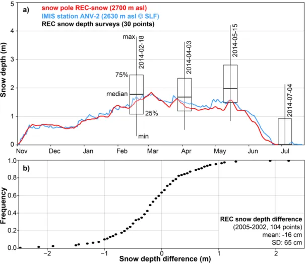
Fig. 2.4: The temporal evolution and spatial variability of snow depth at the Becs de Bosson rock glacier at the Réchy site (REC in Fig. 3.1): a) the coloured lines represent 7-day running means of continuously measured snow depths during winter 2013-2014: in red data from a snow pole on the same landform, in blue from the snow station ANV-2 at ~3 km distance (IMIS data © 2015, SLF). Although the snow depth evolution at these two stations is similar in this particular year, the spatial variability is very large even over short distances. This is illustrated with the boxplots representing the range of snow depth values for 30 monitoring points (~0.15 km2) near to the REC snow pole of roughly similar elevation, slope and aspect at four specific dates. In b) snow depths measured on the same landform in March 2002 and 2005 at 104 points reveal that the spatial snow distribution can greatly differ from year to year with local deviations of up to ±2 m (SD: ±65 cm).
Finally, the definition of the ground-atmosphere boundary as well as the exact snow depth is not trivial. Therefore, snow depth measurements should not be analysed at the cm-scale but for larger variations and in reference to other years. For analysing the effects of terrain and snow heterogeneity on the evolution of mountain permafrost, broad background knowledge about the measurements and the terrain characteristics is required. In the following section, specificities of typical permafrost and periglacial landforms are described.
2.1.3 Characteristics of periglacial landforms
Being a “visible expression of cumulative deformation by long-term creep of ice/debris mixtures under permafrost conditions” (Berthling, 2011: 103), kinematically active rock glaciers (Fig. 2.5d and g) directly indicate the presence and action of permanently frozen ground material and are therefore widely used for permafrost mapping at large scales (Boeckli et al., 2012b; Brenning, 2005; Cremonese et al., 2011). Active rock glaciers usually contain layers of very high ice content, in which relatively thin zones of minimal viscosity (so-called “shear horizons”, Arenson et al., 2002) are responsible for the largest part (>>50 %) of the internal deformation (Sect. 2.3).
As examples from Lapires, Sanetsch, Flüela, Ritord and many other sites show, ice can also be found
for various reasons in other landforms such as talus slopes (Fig. 2.5e) or moraines (Fig. 2.5f).
Particularly in the lower parts of talus slopes, cold ground temperature anomalies have been observed in comparison with the upper parts (Delaloye, 2004). This phenomenon was explained by ascending circulation of cold air throughout the landform during winter when the air outside is colder and more dense, leading to an energy transport towards the top of the talus where the air escapes to the atmosphere again. Since this process is reversible when outside air is warmer and lighter as the air within the ground, the same temperature pattern in the talus is fostered also during summer time. This so-called “chimney effect” was first observed at low-elevation talus slopes below the treeline, where it is dominant for the presence of permafrost (Delaloye et al., 2003; Morard et al., 2008; Wakonigg, 1996). A prominent example in the Swiss Prealps is the “Creux du Van” talus slope located at 1200 m asl. Nevertheless, the chimney effect can play a secondary but still important role also at high elevation (Delaloye and Lambiel, 2005). The chimney effect is not strictly restricted to talus slopes, but may also occur within other landforms situated on steep slopes and consisting of coarse-blocky, porous ground material (Delaloye, 2004).
For other landforms, such as ice-cored moraines and push-moraines, which often contain a higher proportion of fine material, the exposure to cold climatic conditions as well as the integration of ice through geomorphological processes are relevant. Hence, from a geomorphological perspective, the co-existence and interaction between glaciers and permafrost needs to be considered (Harris and Murton, 2005; Lugon et al., 2004). Glacier advances during the little ice age (LIA, 15th-19th century) were responsible for significant changes in the landscape of today, and these are visible in most regions of the Alpine arc on distinct morainic structures. During the LIA, the preservation and formation of ground ice were favoured on the front and outside of advancing glaciers (most typically on push-moraines), whereas areas temporally covered by the ice mass have been thermally insulated and possibly warmed up (Delaloye and Lambiel, 2008). Therefore, the central parts of most LIA glacier forefields in the Alps are nowadays permafrost-free or occupied by degrading
debris-covered glaciers (Fig. 2.5a) or patches of buried ice (Delaloye and Lambiel, 2008). Although the
permafrost definition includes debris-covered glaciers, they are usually considered as glacial features and thus not attributed to permafrost. In comparison with rock glaciers, debris-covered glaciers differ regarding the shape of the borders and the tongue. In contrast to rock glaciers, the kinematic behaviour of debris-covered glaciers is often dominated by a strong vertical component, due to rapid ice loss if the sediment coverage is not thick enough to thermally insulate the ice.
Section 2.1: Mountain permafrost in the Swiss Alps
Fig. 2.5: Overview of periglacial landforms typical for the mountain permafrost domain: a) debris covered glacier at “Entre la Reille” (Les Diablerets, Photo kindly provided by Jean-Baptiste Bosson); b) protalus rampart above “Crap da las Ravulaunas” (Corvatsch, Upper Engadine); c) fractured rock slope of “Chastelets / Corvatsch; d) tongue of a rock glacier in the “Furggentälti” (Gemmi, Bernese Alps); e) talus slope below the “Blanche de Perroc” (Tsarmine, Val d’Arolla); f) push
moraines at “Creux de la Lé” (Sanetsch) and g) characteristic furrows and ridges on the rock glacier Murtèl-Corvatsch.
In summary, periglacial landforms need to be discussed mainly because of their formation and evolution but they do not unambiguously describe the spatial variability of mountain permafrost. For a comprehensive view of specific permafrost landforms, the driving factors of the ground thermal evolution, namely the snow conditions and the topo-climatic and ground characteristics need to be considered. Regarding snow, two major categories can be distinguished, snow-rich (with at least 50-100 cm of snow in late winter, usually insulating the ground for several months) and snow-poor locations. The snow-rich comprises flat or gently inclined terrain, furrows and gullies, the lee side of crests and deposition zones of frequent avalanches, whereas the snow-poor category covers very steep and/or wind-exposed locations. At the latter, GST behaves similarly to air temperature. Both categories could be further separated into sub- categories according to the composition and
structure of the subsurface and the roughness of the surface. A higher roughness decreases the
thermal insulation effect of the snow. In this regard, rock glaciers as well as talus and scree slopes, which consist of very coarse-blocky material, are most likely to contain permafrost. Depending on the geomorphological history, ground ice may originate from former colder climatic conditions, the integration of ice by terrain movements or from in-situ formation due to intense ground cooling.
2.2 Properties and processes influencing the ground thermal regime
The ground thermal regime is mainly influenced by the energy fluxes between the ground surface
and the atmosphere which are temporally and spatially highly variable (Hoelzle et al., 2001; Williams
and Smith, 1989). In contrast, the geothermal heat flux Qg (Wm-2) remains constant for large time scales. For the Alps, 0.08 Wm-2 is a common estimate of Q
g (Medici and Rybach, 1995), but due to topographic and transient effects it is spatially variable as well (Gruber et al., 2004; Harris et al., 2003). However, since the energy fluxes at the ground surface are by factors larger than Qg (Mittaz et al., 2000; Scherler et al., 2014), the geothermal heat flux can be neglected when focusing on the evolution and spatial variability of mountain permafrost at the time scales of years to decades.
2.2.1 Heat and energy exchange at the ground surface
The surface energy balance is the most important boundary condition for permafrost evolution. Theoretically, it can be measured at the point-scale (Mittaz et al., 2000), but to date this is not yet possible for larger areas or a high quantity of points in steep mountainous terrains. Studies based on micro-meteorological data (Sect. 3.3) have shown that the surface energy fluxes depend on point-specific properties, such as the surface albedo, the humidity of the near-surface substrate and the temperature gradient at the ground-atmosphere boundary (Hoelzle et al., 2001; Mittaz et al., 2000; Schneider, 2014). All these properties are greatly influenced by the presence or absence and the
properties of the snow cover (Sect. 2.1.2 and 2.2.2).
The components of the surface energy balance are illustrated in Fig. 2.6a for different topo-climatic and snow conditions. According to Eq. 1, the sum of all energy fluxes equals 0:
0 = + ∆ + + + + h le g m s rad Q Q Q Q Q Q Eq. 1 ↑ ↓ ↑ ↓ + + + =S S L L Qrad Eq. 2
Qrad (Wm-2) corresponds to the net radiation; Qh (Wm-2) to the sensible heat flux, Qle (Wm-2) to the latent heat flux, Qg (Wm-2) to the geothermal (ground) heat flux; ΔQm (Wm-2) to the melt energy at the snow surface and Qs (Wm-2) the heat flux through the snow cover (Scherler et al., 2014; Williams and Smith, 1989). Qrad (Eq. 2) consists of shortwave incoming and outgoing radiation (S↓, S↑ in Wm-2) and longwave components of incoming and outgoing radiation (L↓, L↑ in Wm-2). More detailed descriptions of the surface energy balance can be found in Oke (1987) or Stocker-Mittaz (2002). In most situations temperature and particularly temperature differences (Sect. 3.2) are good approximations for the integral of the surface energy balance at steady-state (Oke, 1987). Based on temperature indices or aggregates, heat and energy fluxes can only be qualitatively estimated. The latent heat of fusion (334 MJm-3 for liquid water) and changes of in the heat capacity (4.18 MJm-3K for liquid water at 0 °C; 2.29 MJm-3K for ice at 0 °C), e.g. due to ice loss, over time need to be considered (Williams and Smith, 1989). In addition to the terrain and snow cover, the substrate greatly influences the heat and energy transport between the surface and the permafrost (Fig. 2.6b-d). It is most complex for coarse blocky substrate because of turbulent fluxes (Sect. 2.2.3 and 2.2.4).
Section 2.2: Properties and processes influencing the ground thermal regime The permafrost is defined as the zone of GT remaining below or at the freezing point of water for two or more years between its base and the permafrost table; the surface layer in which water is subject to annual thawing and freezing is called active layer (Fig. 2.6).
Fig. 2.6: Processes of heat and energy exchange at the ground surface and typical characteristics of mountain permafrost: a) Processes influencing the surface energy balance are illustrated on a fictional terrain with variable snow coverage. On the left, a typical temperature profile is shown, which defines the vertical extent of the permafrost. The shallowest depth at which seasonal temperature variations become nonexistent is called zero annual amplitude (ZAA). Different types of subsurface materials are shown on inset b), where the complexity of the heat transport mechanisms is highest for coarse-blocky substrate. The photographs c) and d) illustrate the heterogeneity of topography, radiation, snow coverage and near-surface substrate on small spatial scales, which make the heat transport over mountain permafrost very complex.
The following section illustrates the high importance of the snow cover for the surface energy balance by comparing snow characteristics with GST time series.
2.2.2 Influence of the snow cover on the surface energy balance
The temporal variability of the snow cover, or more precisely its thermal insulation effect and the modification of the radiation balance, are crucial for the evolution of GST (Gądek and Leszkiewicz, 2010; Goodrich, 1982; Luetschg et al., 2008; Zhang, 2005). The relationship between snow and GST is illustrated in Fig. 2.7 at the example of the Gemmi rock glacier (GFU in Fig. 3.1).
Fig. 2.7: Influence of snow on GST at the example of the Gemmi rock glacier: Panel a) shows the evolution of GST for three different GST loggers (in red, blue and black). On b-e, varying snow conditions over the season are illustrated using webcam images. The geographic position of the thermistors and the time of the four photographs are indicated by arrowheads. During the snow-free period in summer (Fig. 2.7b), GST generally closely follow the variations of air temperature (Fig. 2.7a-b). Daily GST amplitudes may differ depending on the placement depth of the thermistors, the exposure to solar radiation, wind and the moisture content of the surrounding ground material. Logger GFU_S001, which is placed in fine-grained soil material, reacts very sensitively to snow events in autumn and remains at 0 °C for a long period. These so-called zero
curtains (Outcalt et al. 1990) typically persist in non-permafrost areas and occur on permafrost
during the snow melt and freeze-up. The signals of the other two loggers (GFU_S003 and GFU_S015) show considerable short-term variations in early winter because the surrounding subsurface material freezes very quickly and the ground remains influenced by air temperature. The thermal insulation