HAL Id: hal-01121084
https://hal.archives-ouvertes.fr/hal-01121084
Submitted on 11 Nov 2020
HAL is a multi-disciplinary open access
archive for the deposit and dissemination of
sci-entific research documents, whether they are
pub-lished or not. The documents may come from
teaching and research institutions in France or
abroad, or from public or private research centers.
L’archive ouverte pluridisciplinaire HAL, est
destinée au dépôt et à la diffusion de documents
scientifiques de niveau recherche, publiés ou non,
émanant des établissements d’enseignement et de
recherche français ou étrangers, des laboratoires
publics ou privés.
WISDOM GPR investigations in a Mars-analog
environment during the SAFER rover operation
simulation
Sophie Dorizon, Valérie Ciarletti, D. Plettemeier, André-Jean Vieau, W.-S.
Benedix, Marco Mütze, Rafik Hassen-Khodja, Olivier Humeau
To cite this version:
Sophie Dorizon, Valérie Ciarletti, D. Plettemeier, André-Jean Vieau, W.-S. Benedix, et al.. WISDOM
GPR investigations in a Mars-analog environment during the SAFER rover operation simulation.
European Planetary Science Congress 2014, Sep 2014, Cascais, Portugal. pp.EPSC2014-559.
�hal-01121084�
WISDOM GPR investigations in a Mars-analog environment
during the SAFER rover operation simulation
S. Dorizon (1,2), V. Ciarletti (1,2), D. Plettemeier (3), A-J. Vieau (1), W-S. Benedix (3), M.Mütze (3), R. Hassen-Kodja (1),
O. Humeau (1) and the WISDOM and SAFER teams
(1) LATMOS, Guyancourt, France ([email protected]) (2) UVSQ, Versailles, France (3) TUD, Dresden, Germany
Abstract
The WISDOM (Water Ice Subsurface Deposits Observations on Mars) Ground Penetrating Radar has been selected to be onboard the ExoMars 2018 rover mission [1]. This instrument will investigate the Martian shallow subsurface and provide the geological context of the mission, by characterizing the subsurface in terms of structure, stratigraphy and potential buried objects. It will also quantify the geoelectrical properties of the medium, which are directly related to its nature, its water or salts content and its hardness [2]. WISDOM data will provide important clues to guide the drilling operations to location of potential exobiological interest. A prototype available in LATMOS, France, is currently tested in a wide range of natural environments. In this context, the WISDOM team participated in the SAFER (Sample Acquisition Field Experiment with a Rover) field trial that occurred from 7th to 13th October 2013 in the Atacama Desert, Chile. Designed to gather together scientists and engineers in a context of a real Martian mission with a rover, the SAFER trial was the opportunity to use three on-board ExoMars instruments, namely CLUPI (Close-UP Imager), PANCAM (Panoramic Camera) and WISDOM, to investigate the chosen area. We present the results derived from WISDOM data acquired over the SAFER trial site to characterize the shallow subsurface of the area.
1. Introduction
The SAFER trial test site was located close to the Paranal ESO’s Observatory (European Southern Observatorys) while the operations were conducted in the Satellite Applications Catapult remote Center in Harwell, UK. The location was chosen for its well-known resemblance with Mars’ surface and its arid dryness.
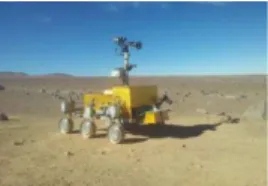
Figure 1 : SAFER rover equipped with the 3 ExoMars instruments in the Atacama Desert, Chile To provide the best from this trial, geologists, engineers and instrumentation scientists teams collaborated by processing and analyzing the data, planning in real time the next trajectories for the rover, as well as the sites of interest for WISDOM subsurface investigations. WISDOM is a polarimetric step-frequency ground penetrating radar, operating in the frequency range [0.5-3] GHz, which allows a resolution of a few centimetres over a few meters depth.
2. Methods to characterize the
subsurface
2.1 Geological context
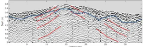
Results derived from WISDOM data can be displayed as radargrams, which represent the dielectric contrasts into the subsurface according to the travel-time of the wave and the horizontal position of the antennas. Radargrams acquired along long profiles provide a rough qualitative geological context (Fig.2).
EPSC Abstracts
Vol. 9, EPSC2014-559, 2014
European Planetary Science Congress 2014
c
Figure 2: Radargram derived from WISDOM data over a 40m length profile. The depositional structure
is characteristic of a sedimentary environment For further investigations about the nature and characteristics of the medium, we use two methods to quantify the geoelectrical properties of the subsurface.
2.2
Permittivity
retrieval
using
a
reference
WISDOM has a specific configuration which permits to retrieve the surface’s permittivity value: the antennas are placed at 30 centimetres above the ground, which enables to record the echo from the surface. The ratio between the amplitude coming from a perfect reflector, such as a metallic plate, and a natural smooth surface provides the reflection coefficient, which is directly linked to the permittivity value.
2.3 Permittivity retrieval using scatterers
signatures
The second method is based on the hyperbolic typical scatterers signature. The shape of the hyperbola is directly related to the depth of the scatterer and the mean permittivity value above the object. In case of a traditional use of GPR, i.e., with antennas placed directly on the surface, the shape can be retrieved analytically. In case of the WISDOM configuration, the refraction occurring at the surface makes the analytical inversion impossible. Therefore, we use a ray-tracing simulation tool, which takes WISDOM configuration into account, in order to produce radargrams of the exact shape of the scatterers signature for varying variety of depths and permittivity values. The best correlation between simulations and data provides the best parameters estimates (Fig.3).
3. Results
The mean permittivity value at the surface retrieved via the reference method for the whole investigated area is ~3.2, with a high spatial variability. Comparisons with laboratory measurements on
samples collected on site are in agreement with these observations. Subsurface permittivity retrievals using the hyperbolic scatterers signatures show an increasing of the permittivity value compared to the surface. This is consistent with the fact that the hardness of the material increases with depth, due to the compaction [2]. Laboratory measurements for collected samples at various depths are in agreement with this phenomenon.
The permittivity estimates allowed us to build radargrams as a function of depth and to compare identified interfaces with actual drillings. Direct observations are in good agreement with identified layers on the radargrams.
4. Summary and Conclusions
The SAFER trial was the opportunity for the WISDOM team to test the instrument in a real context of a Martian mission with a rover. WISDOM functioning during this trial was nominal, with a penetration depth at ~2m and a resolution of a few centimetres. Radargrams derived from the WISDOM data and the analysis of frequency dependent phenomena help to constrain the geological context, in this specific case a sedimentary depositional environment. Two methods are used to retrieve the geoelectrical properties on the surface and into the subsurface. This provides an estimate of the permittivity as a function of depth and helps characterizing the compaction rate or hardness of the material. Direct observations, laboratory measurements and WISDOM data are in good agreement.
Acknowledgements
The funding WISDOM development and this research are supported by French CNES, UVSQ and German DLR. We also address our acknowledgments to the entire SAFER team.
References
1] Ciarletti V et al: WISDOM, a GPR designed for shallow and high resolution sounding of the Martian subsurface, 0023-SIP-PIEE, 2010
[2] ElShafie A, Heggy E: Dielectric and hardness measurements of planetary analog rocks in support of in-situ subsurface sampling, Planetary and Space Science, 2013