HAL Id: tel-00956812
https://tel.archives-ouvertes.fr/tel-00956812v2
Submitted on 24 Oct 2017HAL is a multi-disciplinary open access archive for the deposit and dissemination of sci-entific research documents, whether they are pub-lished or not. The documents may come from teaching and research institutions in France or abroad, or from public or private research centers.
L’archive ouverte pluridisciplinaire HAL, est destinée au dépôt et à la diffusion de documents scientifiques de niveau recherche, publiés ou non, émanant des établissements d’enseignement et de recherche français ou étrangers, des laboratoires publics ou privés.
Imad Afyouni
To cite this version:
Imad Afyouni. Knowledge representation and management in indoor mobile environments. Mobile Computing. Université de Bretagne occidentale - Brest, 2013. English. �NNT : 2013BRES0061�. �tel-00956812v2�
!"#$%"&'()*$%+(%'*'$(%,( .(/!#01%.#%,20'-3#1$-!#%.#%+1#$! 6'-1."-%7%8"9%*'%&)%9'-1."-#4567%85495:;67%87<%$/-#'/#$%87%6;%)#1% !"#$%"&'()*$%+(%'*'$(%,( .(/!#01%.#%620'-3#1$-!#%.#%+1#$! !32(.)&.12%7%:-;"09)1.<#' #4567%.5495:;67%87<%$4=7>47<%87%6;%)7:% 8$-!/$-(%9%+:6)*'-%;*<'(%,(%$(=>($=>(%?)@ABACD 7/E/+%2=/,(1F%G(.(/$=>%0).'*'#'(%
H%I)"J+(,K(%G(!$(.()'/'*")%
/),%;/)/K(1()'%*)%0),""$%
;"&*+(%L)E*$")1()'.%M
!?@<7%<5A97>A7%67%BC%<7D97EF:7%GHBI ,(E/)'%+(%N#$F%="1!".-%,(%O !?=7::J%.7659 8$"P(..(#$.%,(.%#)*E($.*'-.%Q%6)*ER%,(%S/+()=*())(.%Q%07G02%T*++(%U%0)33"01'#0 "7:KL%);:9=>% 8$"P(..(#$.%,(.%#)*E($.*'-.%Q%V*$(='(#$%,#%T/&"$/'"*$(%,W0)P"$1/'*X#(%,(%Y$()"&+(%U% 0)33"01'#0 M;4NA7<%!=<<7;A 8$"P(..(#$.%,(.%#)*E($.*'-.%Q%V*$(='(#$%,(%+WL70Z%Z$(.'%U%'=)9.-)1'#0 O;:=>7%P7=95A>= 8$"P(..(#$.%,(.%#)*E($.*'-.%Q%6)*ER%,(%S($./*++(.[%8/$*.%U%'=)9.-)1'#0 $7:Q=5%-6;::= 2.."=*/'(%!$"P(.."$%Q%6)*E($.*'F%"P%\/$/K"]/%U%0)E*'-/?:=<95D?7%/,*1*)0'! 8$"P(..(#$.%,(.%#)*E($.*'-.%Q%V*$(='(#$%,(%+W0GL7/E%Q%L="+(%7/E/+([%Z$(.'%U%V*$(='(#$%,(%'>^.( /J:=6%1*R ;/_'$(%,(%=")P-$()=(.%Q%0GL7/E%Q%L="+(%7/E/+([%Z$(.'%U%`"Q,*$(='(#$%,(%'>^.( !!!!!!!!!!!!!!!!!!!!!!!!!présentée à
l’Université de Bretagne Occidentale
pour obtenir le titre de
Docteur de l’Université de Bretagne Occidentale
Mention Informatique
par
Imad AFYOUNI
Knowledge Representation and Management in
Indoor Mobile Environments
soutenue le 17 septembre 2013 devant la commission d’examen :
Composition du Jury
Rapporteurs :
Pr. Thierry Delot, Université de Valenciennes – INRIA Lille
Pr. Hervé Martin, Université de Grenoble
Examinateurs :
Pr. Jacques Tisseau, ENIB Brest
Pr. Karine Zeitouni, Université de Versailles (UVSQ)
Invité :
Dr. Sergio Ilarri, University of Zaragoza
Co-Directeur :
Dr. Cyril Ray, IRENav Brest
Directeur :
Pr. Christophe Claramunt, IRENav Brest
One of the joys of completion this Ph.D. is to look over the journey past and remember all the friends and family who have helped and supported me along this long but successful adventure.
I would like to express my sincere gratitude to Professor Christophe Claramunt and Dr. Cyril Ray, who are not only advisors but dear friends. I could not have asked for better role models, each inspirational, supportive, and patient. You have also given me the freedom to pursue various research directions without objection. Christophe, I hope that I could be as lively, enthusiastic, and energetic as you and to someday be able to command an audience as well as you can. Cyril, I am very grateful for the many insightful discussions and suggestions; you were always my primary resource for getting my science questions answered.
I would also like to thank the members of my Ph.D. committee, Professor Thierry Delot, Professor Hervé Martin, Professor Jacques Tisseau, Professor Karine Zeitouni, and Associate Professor Sergio Ilarri, who provided encouraging and constructive feedback. It is not an easy task to review a thesis, and I am grateful for their thoughtful and detailed comments. Special thanks go to Dr. Sergio Ilarri for his patience, understanding, guidance, and most of all the encouragement he has given me during my thesis. Your hard work is very much appreciated! Keep up the great work!! Regarding funding, my thanks go to the French Ministry of Defense, and to the Naval Academy represented by the Rear Admiral Philippe Hello. I thank all the present and past members of the MoTIM group of the Naval Academy Research Institute (IRENav): my gratitue goes especially to Abdel (extremely knowledgeable, helpful, and friendly), Rémy (supportive, very pleasant, and inspiring), Éric (a friendly and knowledgeable expert, I enjoyed teaching by your side), David (a nice and helpful friend who has been pretty supportive during my search for jobs and writing), and Joseph (a great personality, I also enjoyed hearing from you about your beautiful missions overseas). I also thank Rozenne, Laurent, Delphine, and Valérie from the Underwater Acoustics part of our team and the members of the M2EN group (Jacques-André, Jean-Yves, Jean-Pierre, Patrick, Jean-Frédéric, François, Céline, Thomas, Frédéric, Franck, and Hocine) who have been so helpful and made me feel very welcome when I first arrived to IRENav. I?ll also not forget the institute administrative assistants (Marie - great personality, great performance!), Capitaine Savary, Magalie, Christine, Luc, Jacques, and the SAGA team) whose friendly attitude and willingness to carry out
all manner of tasks in the shortest possible time and with the highest possible levels of enthusiasm are greatly appreciated.
I also thank my friends and colleagues; I list a few from IRENav: Georges (great friend! I’ll never forget your help and support when I broke my leg), Emerry (cooool! best luck :)), Laurent Etienne (so friendly and I’m glad to have you as a friend), Pierre-Luc (great coach!), Géraldine (very supportive), Ali (best friend!), Nicolas (carambar, nutella, etc.), Mathieu and Lamia (funny, friendly, and very supportive), Dieudonné, Zhibin, Ashraf, Clément, Jingya, Arnaud, Ines, Sofiane, Jean-Baptiste, Alex, Julien, etc. A few from outside: Ramez, Ayman, Ali, Kamal, Mustapha; I keep great and fun moments with you.
Outside of Brest, I thank all staff of the department of Computer Languages and Systems Engineering at the University of Zaragoza for the opportunity to meet with you. It was exciting to be part of the Distributed Information Systems (SID) team - a very knowledgeable, fun, and friendly group of people. Special thanks to Roberto for helping me get used to life in Zaragoza quickly.
Most sincerely, I thank my parents, Taha and Karima, for providing me unconditional love and care. Without you, I never would have made it here; thank you for everything and I miss you so much. My thanks also go to my brother and sisters. You have been my best friends all my life; I love you dearly and thank you for all your advice and support. I am also grateful to my family-in-law, especially my mother-in-law Halima for warm-heartedness. Finally, the best outcome from these past several years is finding my best friend, soul-mate, and wife Naamat. I praise Allah for sending me you my love, there are no words to convey how much I love you. These past several years have not been an easy ride, both academically and personally for both of us. I feel that we both learned a lot about life and this strengthened our commitment and determination to each other. Thank you my dear sweet love for sharing my dreams.
Ahead of all, all praise is due to Allah, without whom I could not have accomplished anything. No amount of gratefulness will be enough to thank Allah for the blessings and guidance he have given me. I pray for Allah’s support and guidance in the rest of my career and my life.
Contents i
List of Figures vii
List of Algorithms ix
List of Tables xi
INTRODUCTION 1
Research context . . . 3
Motivation and research challenges . . . 5
Research objectives . . . 9
Thesis outline . . . 11
I CONTEXT-AWARE INDOOR NAVIGATION 13 1 Requirements for Context-Aware Indoor Navigation Systems 15 1.1 On the role of context in mobile computing . . . 16
1.2 Challenges in context-dependent indoor data models . . . 17
1.2.1 Service-oriented requirements . . . 18
1.2.1.1 Localisation. . . 18
1.2.1.2 Context-aware, adaptive navigation . . . 20
1.2.1.4 Activity-oriented interactions . . . 22
1.2.1.5 Spatial & behavioural analyses . . . 23
1.2.2 Efficiency-related requirements . . . 24
1.2.2.1 Modelling effort . . . 24
1.2.2.2 Flexibility. . . 24
1.2.2.3 Performance and scalability . . . 25
1.3 Data management issues in location-aware services and queries . . . 26
1.3.1 Location-based services and queries . . . 26
1.3.2 Continuous and adaptive query processing paradigms . . . 28
1.3.2.1 Managing moving objects . . . 30
1.3.2.2 Continuous evaluation of location-dependent queries . . . 32
1.3.3 Query languages for location-dependent queries . . . 33
1.4 Discussion . . . 34
1.5 Summary . . . 35
II RELATED WORK 37 2 Spatial Models for Indoor Context-Aware Navigation Systems 39 2.1 Introduction . . . 39
2.2 A taxonomy of indoor spatial models . . . 40
2.2.1 Geometric-based approaches . . . 40
2.2.1.1 Cell-based models . . . 41
2.2.1.2 Boundary-based models . . . 46
2.2.2 Symbolic-based approaches . . . 47
2.2.2.1 Set-based symbolic models . . . 47
2.2.2.2 Graph-based models . . . 50
2.2.3 Discussion . . . 54
2.2.3.1 Geometric-based approaches . . . 56
2.2.3.3 Application perspective . . . 56
2.3 Towards hybrid spatial models . . . 57
3 Continuous Location-Dependent Query Processing 61 3.1 Need for incremental and adaptive query processing. . . 61
3.2 Architectures for location-dependent query processing . . . 63
3.2.1 Continuous query processing in moving object databases . . . 63
3.2.2 Approaches for location-dependent query processing over data streams . . . . 67
3.2.3 Approaches for managing and querying indoor moving objects. . . 70
3.2.4 Towards context and preference-aware location-dependent queries . . . 71
3.3 Continuous processing of navigation-related queries . . . 73
3.3.1 Query processing in spatial network databases. . . 75
3.3.2 Path queries. . . 76
3.3.2.1 Multi-criteria & hierarchical path searches. . . 76
3.3.2.2 Continuous path search algorithms . . . 78
3.3.3 Range queries . . . 79
3.3.4 Other kinds of location-dependent queries . . . 81
3.3.4.1 Nearest neighbour queries . . . 82
3.3.4.2 Reachability Queries and Reverse Range and kNN Queries . . . 83
3.4 Languages for location-dependent queries . . . 84
3.4.1 Query languages in moving object databases. . . 84
3.4.2 Data types and operations for spatio-temporal data streams . . . 86
3.4.3 Languages for querying preference-aware and context data . . . 87
3.5 Conclusions . . . 89
III DATA MODEL, QUERY LANGUAGE, ALGORITHMS, AND SYS-TEM DESIGN 91 4 A Hierarchical and Context-Dependent Indoor Data Model 93 4.1 Need for a hierarchical and context-dependent data model . . . 93
4.2 Modelling approach. . . 94
4.2.1 Spatial component . . . 96
4.2.1.1 Core spatial layer . . . 97
4.2.1.2 Coarser spatial layers . . . 101
4.2.2 Feature component . . . 105
4.2.2.1 Principles . . . 105
4.2.2.2 User profiles . . . 108
4.2.2.3 Real-time event management . . . 109
4.2.3 Action component . . . 110
4.3 Conclusions . . . 111
5 A Language for Continuous Location-Dependent Queries in Indoor Environ-ments 113 5.1 Continuous query processing architecture . . . 114
5.1.1 Principles . . . 114
5.1.2 Architecture overview . . . 116
5.1.2.1 Route management . . . 117
5.1.2.2 Distribution management . . . 118
5.2 A language for continuous location-dependent queries. . . 119
5.2.1 Principles . . . 120
5.2.2 Query semantics . . . 122
5.2.3 Managing and representing location granules . . . 123
5.2.4 Motivating examples of location-dependent queries . . . 125
5.3 Discussion . . . 129
6 Algorithms for Continuous Path and Range Queries in Indoor Mobile Environ-ments 131 6.1 Hierarchical and incremental processing of continuous LDQs . . . 132
6.2 Continuous processing of indoor path queries . . . 132
6.2.2 Hierarchical and incremental path search algorithm . . . 134
6.2.2.1 Hierarchical path search . . . 137
6.2.2.2 Continuous query processing . . . 138
6.3 Continuous processing of indoor range queries . . . 141
6.3.1 Hierarchical range network expansion. . . 141
6.3.2 Incremental algorithm for continuous range search . . . 144
6.4 Discussion . . . 147
7 A PostgreSQL Extension for Continuous Location-Dependent Query Processing149 7.1 Comparative study of existing platforms for handling LDQs . . . 150
7.2 System implementation . . . 154 7.2.1 Overview . . . 154 7.2.2 Optimization . . . 155 7.3 Experimental evaluation . . . 156 7.3.1 Experimental settings . . . 157 7.3.2 Experimental results . . . 159 7.3.3 System Scalability . . . 161
7.3.4 Summary of the experiments . . . 163
7.4 Conclusions . . . 164
CONCLUSIONS AND FUTURE WORK 165
List of Publications 175
1 Challenges in data & knowledge representation covered in the thesis . . . 6
2 Challenges in data management discussed in the thesis . . . 7
3 Major fields covered and/or related to this thesis . . . 9
1.1 Classification of contextual dimensions . . . 17
2.1 Grid tessellation of a floor plan based on either (a) square or (b) hexagonal cells . . . . 41
2.2 Examples of free-space tessellation techniques. . . 43
2.3 A generalised Voronoi diagram of an indoor space [Wallgrun, 2005]. . . 44
2.4 Example of a floor plan designed using a CAD system . . . 46
2.5 Example of a place-based set model . . . 49
2.6 Example of an object-oriented model of an indoor space . . . 50
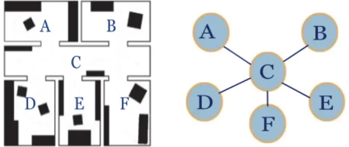
2.7 An place graph representing structural entities of an indoor space . . . 51
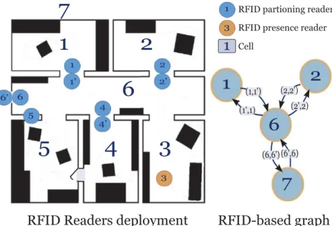
2.8 Example of a sensor-based graph . . . 53
2.9 Example of a fine-grained graph of a floor plan . . . 54
4.1 Indoor spatial model as a core component of a context-aware indoor system . . . 95
4.2 A fine-grained network of a two-storey building: first level of the hierarchical spatial data model . . . 98
4.3 A fine-grained network of a two-storey building: first level of the hierarchical spatial data model . . . 99
4.4 A closer view of the fine-grained graph (Vmicro, Emicro) at Room 113 (R113) of the first floor . . . 99
4.5 Part of the exit hierarchy derived from the fine-grained graph (Floor-01, Building-1) . . 102
4.6 Part of the location hierarchy derived from the fine-grained graph (Floor-01, Building-1); “HW ” stands for Hallway, “MR” for Meeting Room, “R” for Room, and “BT ” for Bathroom104 4.7 Links between neighbouring layers of the hierarchical data model. . . 105
4.8 Interaction spaces of features evolving or located in space . . . 107
4.9 Classification of user profiles based on access control information . . . 108
4.10 Actions performed by different types of features . . . 110
5.1 Execution of location-dependent queries in indoor environments . . . 115
5.2 Query grammar for location-dependent queries in an indoor environment . . . 121
6.1 Hierarchical and incremental path search algorithm . . . 137
6.2 Incremental algorithm for continuous range search: A range of 50 meters is applied in this example . . . 143
7.1 Varying the distance parameter: Hierarchical vs. non-Hierarchical Continuous Path Search159 7.2 Varying the radius: Hierarchical vs. non-Hierarchical Continuous Range Search . . . 160
7.3 Varying the number of moving objects: Hierarchical vs. non-Hierarchical Continuous Range Search. . . 161
7.4 Varying the number of concurrent access: Hierarchical Continuous Path Search . . . 162
1 HierarchicalPathSearch(locRef, locTarg, out outPath, out outLength) . . . 136
2 ContinuousHPath(refObjId, tarObjId) . . . 139
3 HierarchicalNetworkExpansion(refObjId, radius, objectIds[]) . . . 142
1.1 Taxonomy of continuous location-dependent queries . . . 29
2.1 Assessment of geometric-based approaches . . . 45
2.2 Assessment of symbolic approaches . . . 55
3.1 Cooperation from moving objects [Adapted from [Ilarri et al., 2010]] . . . 65
3.2 Approaches that assume known objects’ trajectories . . . 66
3.3 Generic query processing architectures in moving object databases . . . 68
3.4 Approaches for query processing over spatio-temporal data streams . . . 70
3.5 Context- and preference-aware query processing approaches . . . 74
The range of applications in ambient information systems progressively evolves from large to small scale environments. This is particularly the case for applications that assist humans in navigation-related activities in indoor spaces (e.g., airports, museums, office buildings). The research presented by this Ph.D. dissertation develops a data and knowledge representation of an indoor environment that takes into account user-centred contextual dimensions and mobile data management issues. We introduce a hierarchical, context-dependent, and feature-based indoor spatial data model. This model takes into account additional contextual dimensions such as time, user profiles, and real-time events. The model is based on a tree structure in which location information is represented at different levels of abstraction. The hierarchical design favours performance and scalability of location-dependent query processing. A query grammar is developed and implemented on top of that model. This query language supports continuous location-dependent queries and takes into account user preferences at execution time. The concept of location granules is introduced at the query execution and presentation levels.
This modelling approach is complemented by the development of a generic architecture for continuous query processing. Several algorithms for location-dependent query processing over indoor moving objects have been designed and implemented. These algorithms include path searches and range queries applied to both static and moving objects. They are based on an incremental approach in order to execute continuous location-dependent queries. The operators and constraints introduced in the query language and the algorithms for location-dependent query processing have been implemented as a database extension of the open source DBMS PostgreSQL, and where the hierarchical network-based indoor data model has been developed at the logical level. Several experiments have been conducted to evaluate the scalability and performance of the whole framework.
Keywords
Indoor data models, context-aware systems, mobile data management, continuous location-dependent queries, moving objects
Research context
The last decades have seen a tremendous growth in mobile computing and advanced wireless technologies and services. Mobile computing systems take advantage of rapidly evolving wireless technologies to provide end users with personalised and innovative services. Thanks to the portability and processing power of new mobile devices such as Smartphones and Tablets (e.g., iPhone, iPad, and Android-based devices), as well as their extended battery life, a wide range of regularly available and computationally intensive mobile services can be developed and offered to end users. The availability of mobile information systems is driven by the increasing demand of services that provide data access to users anytime and anywhere. For instance, a report recently published by the International Telecommunication Union (ITU) estimates that about 6 billion mobile phone subscriptions at the end of 2011, out of which 1.08 billion are Smartphones (Go-Gulf, 2012). By 2016,eMarketerexpects that 2.1 billion active mobile users worldwide will be using Android/iOS applications alone.
A further step in this development has been foreseen by Marc Weiser in the early 1990s and was referred to as Ubiquitous Computing [Weiser, 1993] (also called Pervasive Computing [Satyanarayanan, 2001]), in which interconnected smart devices are embedded unobtrusively in everyday environments, and are able to communicate and cooperate in order to offer personalised and adaptive services to human users. In his seminal work on the next generation of computing technologies for the 21st century, Marc Weiser stated that [Weiser,1991]:
“The most profound technologies are those that disappear. They weave themselves into the fabric of everyday life until they are indistinguishable from it”.
A more precise definition of Ubiquitous and Pervasive Computing can be derived from the Oxford Dictionary, where Ubiquitous is defined as:
And that of Pervasive:
“Adjective: (especially of an unwelcome influence or physical effect) spreading widely throughout an area or a group of people”.
Ubiquitous computing becomes a reality thanks to emerging seamless environments of comput-ing, where smart artefacts and sensors, enabled by recent developments in sensor technologies, can collect huge amounts of data and interact among themselves to offer advanced and adapted services. The miniaturization of smart devices helps users in their every-day life activities by providing them with computational abilities in a smart way, and with minimum user involvement.
Another key enabler of pervasive computing environments, apart from the networking infras-tructure, relies in the successful integration of semantics and advanced reasoning techniques into mobile information systems. Those features have been recently characterized under the so-called Ambient Intelligence (AmI) technologies [Aarts and Wichert,2009]. An ambient system is expected to be sensitive, responsive, adaptive, transparent, ubiquitous, and intelligent [Cook et al.,2009]. Applications of ambient systems mainly include “smart spaces” such as smart cities, smart homes, and smart offices, which seek to seamlessly support people in their daily lives.
The range of applications in ambient information systems is progressively evolving from large outdoor environments (e.g., Smart Cities) to small scale indoor environments (Smart Homes, Smart Offices). Indoor spaces are closely related to ambient systems where sensors provide real-time data without direct human interaction. An indoor space can be informally defined as a built environment where people usually behave [Li,2008] (e.g., buildings, commercial malls). Amongst many factors, recent developments of ubiquitous computing and indoor positioning techniques have largely favoured mobile application development to indoor spaces [Kolodziej and Hjelm, 2006]. Nowadays, techniques currently available for indoor positioning range from radio-based technologies (WLAN, RFID, Bluetooth) to non-radio technologies (Infrared and Ultrasound) and inertial navigation systems (INS) [Kolodziej and Hjelm,2006]. Moreover, hybrid approaches appear as promising solutions providing reliable, continuous, and accurate location information [Torres-Solis et al.,2010].
Mobile location-aware services have attracted recent research attention as their development is expected to have significant impact for users in both indoor and outdoor environments [Schiller and Voisard, 2004; Yu and Spaccapietra, 2010]. Location-aware services provide the user with the ability to interact with his/her physical surroundings in order to achieve some tasks. More generally, context-aware systems exploit contextual dimensions such as user-centred dimensions (e.g., user profile, user’s physical/cognitive capabilities), environmental context (e.g., location), temporal context, and context of execution (e.g., network connectivity, nearby resources). This allows to anticipate user’s needs and to customize his/her navigation experience [Baldauf et al.,2007].
A successful integration of indoor knowledge representation (i.e., model of space, objects of interest, user profile and activities, etc.) and ambient systems still requires the development of appropriate spatial data structures and data management facilities. We believe that this is a mandatory development for the delivery of intelligent-based context-aware systems applied to indoor spaces. More specifically, the research presented in this thesis focuses on “context-aware indoor navigation systems” in the context of mobile location-aware services.
Motivation and research challenges
There is a growing need for applications that assist humans in their navigation-related activities in indoor spaces. Real-time, continuous, and reliable user guidance in a time-dependent manner is required not only in transit structures such as train stations or airports, but also in museums, hospitals, campuses, and buildings. Moreover, diverse kinds of services can be provided by enabling real-time integration of contextual dimensions into an underlying data model and an associated query processing engine. This includes not only everyday activities and tasks, but also emergency situations and evacuation processes where real-time and reliable responses are particularly crucial, as well as services that support collaborative tasks such as healthcare activities in a pervasive hospital environment [Bardram,2005;Oliveira et al.,2010].
Despite the continuous development and improvements made in mobile computing and the variety of technologies that can be used to enable ambient intelligence environments, there are still many research challenges that need to be addressed [Cook et al.,2009]. Amongst the many challenges facing the development of context-aware indoor navigation systems, knowledge representation and management issues in indoor mobile environments are studied in this thesis.
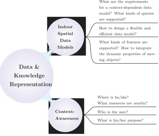
Many research questions on how to design a flexible, context-dependent, and efficient indoor data model that incorporates the dynamic properties of the environment still need to be addressed (Figure1). Additional issues on the incorporation of context-awareness into the data model require further investigation. Notwithstanding their smaller size with respect to outdoor environments, effective modelling of indoor environments can be fairly complex. Thus, data models and methods for outdoor navigation cannot be directly applied. For instance, an indoor data model should take topological configurations into account (e.g., connectivity or adjacency relationships between rooms or floors in a building). In addition, location information, which is often defined with absolute coordinates in outdoor environments, is more likely to be described in relative terms for both physical and functional spaces in indoor environments (e.g., John’s office) [Walton and Worboys, 2012]. Moreover, interactions among humans and/or other objects in an indoor space are usually more
frequent than in an outdoor one, which is usually beyond the range of humans’ physical interactions. Furthermore, in contrast to car navigation, the main differences of human navigation relies in the degrees of freedom in movement, the velocity of movement, and the level of granularity.
Data &
Knowledge
Representation
Indoor Spatial Data Models Context-AwarenessHow to design a flexible and efficient data model? What kinds of features are supported? How to integrate the dynamic properties of mov-ing objects?
What are the requirements for a context-dependent data model? What kinds of queries are supported?
Who is the user? Where is he/she?
What resources are nearby?
What is his/her purpose?
Figure 1: Challenges in data & knowledge representation covered in the thesis
A knowledge-based representation of an indoor environment should take into account the hierarchical layout of the indoor space and: (i) all static/moving features that populate an indoor environment, where a feature can refer to either a person (i.e., a mobile user or any other social entity of interest1) or an object/event of interest (e.g., sensors, exits, tables, continuous phenomena such as a fire, etc.); (ii) the spatial properties associated with those features (e.g., location and extent); and (iii) the behaviours that emerge from them (i.e., how these objects can interact and communicate within the environment).
Issues regarding data management and processing of location-dependent queries are also of particular interest in this context (Figure 2). Location-Dependent Queries (LDQs), also referred to as location-based queries [Zhang et al.,2003;Mokbel,2005], constitute a key building block in
context-aware indoor navigation systems. A location-dependent query is a query whose answer depends on the locations of the objects of interest. From a query processing perspective, indoor environments have brought special features and constraints (e.g., multiple floors, stairs, lifts, access privileges, etc.) that should be considered when processing location-dependent queries. Moreover, taking advantage of contextual information favours more appropriate query answers and real-time adjustments according to user preferences and contextual constraints. Those specific properties and requirements for a knowledge-based representation of an indoor mobile environment raise different questions on (Figure2): 1) how to represent and manage static/moving objects and other entities of interest? 2) how those objects are taken into account during query processing? and 3) what kind of processing architecture do location-dependent queries need?
Data
Management
Query Processing Query LanguagesHow to process LDQs over indoor moving objects? What kind of processing archi-tecture do LDQs need? How frequently updated lo-cations of moving objects are handled in real-time?
How to express indoor location-dependent queries? How can the hierarchical lay-out of the indoor environment be reflected?
How to integrate user pref-erences and semantics in the query grammar?
Figure 2: Challenges in data management discussed in the thesis
An appropriate management of static and dynamic data is a key issue for processing these queries, since the result of a query is only valid for a particular location of the query issuer and for certain locations of the objects of interest. As those queries are time-sensitive and location-dependent, they may be valid for only a given period of time (e.g., shops in a mall have certain opening hours and are not available outside that schedule), and within a given area. Therefore, those
queries are expected to be processed as continuous queries [Terry et al.,1992], which means that the system should continually keep the answers up-to-date over a certain period of time (usually, until the query is explicitly cancelled by the user). Dataflow processing applications often have a monitoring or filtering aspect in which queries are continuously active. Therefore, continuous location-dependent queries appear to have considerable impact for the development of different categories of location-based and context-aware services.
Location-dependent queries [Ilarri et al., 2010; Wang and Zimmermann, 2011], and more generally context-dependent queries, represent typical examples of pull-based services (i.e., requests are triggered by the user), and which are needed in such context-aware systems, as well as a key building block to detect situations of interest for push-based services (i.e., services initiated by the service provider without having been requested by the user). The context-dependent character of these queries means that any change in the context (e.g., changes in the locations and/or profiles of the objects that are involved in the query) may significantly affect the answer. For example, if a user wants to find out his/her friends within a range of 100 meters while navigating a shopping centre, the answer depends on both the user’s current position and the location of the nearby friends. This type of query is particularly challenging because, in most cases, the user and the entities relevant for the query (e.g., the friends of the user) are moving. Most work on location-dependent query processing has been developed for outdoor environments [Ilarri et al.,2010]. For indoor spaces, approaches for query processing based on spatial networks instead of free Euclidean space are preferred and more realistic. However, existing approaches for network-based query processing usually assume an outdoor environment [Deng et al.,2009;Lee et al.,2005;Papadias et al.,2003], where for instance hierarchical networks do not naturally appear.
Query languages designed for location-dependent queries over moving objects are strongly related to the data model underneath, and on how moving object data is managed [Erwig and Schneider, 1999]. Therefore, additional challenges on how to express the semantics behind different kinds of location-dependent queries over indoor moving objects, and how to incorporate user preferences and other semantics into the query model are also of interest in this context (Figure 2). This requires the design of a query grammar that supports navigation-related queries, and which takes into consideration other properties such as the hierarchical layout of the indoor space for presentation of query results as well as for query processing purposes.
Research objectives
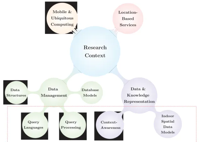
The research presented in this thesis studies location- and context-aware services and queries in indoor environments, with a special focus on navigation-related queries. A unique combination of challenges arises, as the proposal must be able to represent different kinds of location-dependent queries in a flexible manner, and to take into account additional contextual information, time-dependency, and the hierarchical layout of the indoor environment. Some of the challenges that are presented and addressed in this thesis are covered within different fields of research. The major research fields covered and/or related to this thesis are illustrated in Figure3. Research on context-aware navigation in indoor mobile environments inherits challenges of both research fields: Mobile and ubiquitous computing, and location-based services. Challenges in knowledge representation and management are mainly addressed in this thesis. Particularly, indoor spatial data models, context-awareness, query languages, and query processing parts are presented along the contributions of this thesis from Chapter4to Chapter 7. Research Context Data & Knowledge Representation Indoor Spatial Data Models Context-Awareness Data Management Database Models Query Processing Query Languages Data Structures Mobile & Ubiquitous Computing Location-Based Services
Figure 3: Major fields covered and/or related to this thesis
“A data and knowledge representation of indoor mobile environments incorporated with user-centred context-awareness, and to address data management issues in indoor context-aware navigation systems. The underlying principles that represent a context-aware indoor data model are introduced, as well as a query language and algorithms for the continuous location-dependent query processing in indoor environments.”
To achieve these goals we propose the following approach:
1. To model and design a hierarchical and context-dependent indoor spatial and feature-based data model that can be viewed as a tree structure in which location information is represented at different levels of abstraction. This hierarchical design alleviates performance and scalability issues in location-dependent query processing. In addition, time-dependent functions that compute network distances and travel times are introduced. Furthermore, a classification of user profiles is presented in order to perform an offline filtering of the multi-level data model, thus reducing the amount of data that need to be processed in real-time.
2. To design a generic architecture used for the continuous processing of location-dependent queries in indoor environments. Navigation-related queries are processed in accordance with this architecture, and are continually executed while the request is not explicitly cancelled by the user. Moreover, a query grammar is also presented to express location-dependent queries. This grammar supports navigation queries and incorporates some other preferences and semantics in the query model. It also supports the hierarchical data model by using the concept of locations granules to represent different levels of abstraction.
3. To develop algorithms for the continuous processing of location-dependent queries. Particularly, algorithms for hierarchical path searches and range queries applied to both static and moving objects are introduced. Those algorithms take advantage of the hierarchical data model of the indoor environment, and apply an incremental approach in order to efficiently execute continuous location-dependent queries, thus avoiding solving each search problem independently from scratch.
4. To design and implement a database extension based on the open source DBMS PostgreSQL. This prototype handles continuous path searches and range queries on top of the hierarchical network-based indoor data model. The main parts of the prototype developed are: (i) a hierarchical network-based data model of indoor environments; (ii) operators and location-dependent constraints introduced in the query grammar; and (iii) algorithms to process continuous location-dependent queries over moving objects.
Clearly the scope of this thesis does not cover all issues and challenges that face the design and development of context-aware indoor navigation systems. Although many challenges regarding recent techniques for indoor positioning are of great interest for context-aware indoor navigation, and are strongly related to our research field, they are not further addressed in detail here. Indeed, the goal pursued in this work is to abstract our approach from specific positioning techniques as far as possible, while considering that a hierarchical data model can be suited to different kinds of positioning techniques (cf., Chapter1 for more details).
Additional research fields that cover issues on database models and challenging problems in data structures, and indexing methods are discussed in Chapters3and7, so that technical decisions are made for the prototype implementation, without being involved into those research challenges.
Thesis outline
This thesis is organized into three parts and seven chapters. The first part establishes a common ground for the development of a flexible and efficient context-aware indoor navigation system. The second part acts as a literature review of indoor spatial knowledge representations and location-dependent query processing techniques, respectively. The third part describes our methodology by presenting the main contributions in four different chapters. The structure of the thesis is organized as follows:
Chapter 1 presents the basic concepts of context-aware indoor navigation, and introduces preliminary recommendations for the development of indoor spatial data models from a context-aware systems perspective. Moreover, the role of contextual information is discussed, and how it can be incorporated into the data model. From a data management perspective, a set of requirements are also discussed with the aim of designing a real-time system for ambient intelligence environments.
Chapter 2 surveys indoor spatial data models developed for research fields ranging from mobile robot mapping to indoor location-based services (LBS), and most recently to context-aware navigation services applied to indoor environments. A taxonomy of models is presented and assessed with the aim of providing a flexible spatial data model for navigation purposes, and by taking into account the contextual dimensions.
Chapter 3discusses related work on location-dependent query processing in both outdoor and indoor mobile environments. Different models and systems for handling moving objects in databases are reviewed. A special focus on the continuous processing of navigation-related queries, namely path, range, and nearest neighbour queries, is then made by considering the algorithmic aspects and
the different query processing techniques. Moreover, languages for querying location-dependent and other contextual data are also presented.
Chapter 4 introduces a hierarchical and context-dependent data model that represents an indoor space at different levels of abstraction. Other components such as the feature component, which represents mobile persons and objects of interest, and the action component are also presented. The management of user profiles and real-time events are further highlighted.
Chapter 5 first proposes a generic architecture for the continuous processing of location-dependent queries, and describes the main components considered in the architecture, and then discusses some data distribution issues. Secondly, the semantics of a continuous-based query language are introduced, which incorporates navigation-related queries along with some other preferences in the query model. Finally, some motivating sample queries are illustrated.
Chapter 6 presents several continuous processing algorithms for handling hierarchical path searches and range queries over mobile objects in indoor environments. The principles of an incremental and hierarchical-based approach are introduced for both kinds of queries. In addition, descriptions along with pseudocodes of the corresponding algorithms are provided.
Chapter7discusses the design and implementation of a database extension based on the open source DBMS PostgreSQL. This prototype handles continuous path searches and range queries on top of the hierarchical network-based data model of the indoor environment. The main parts of the prototype developed are presented. Results of the experiments, that have been conducted to investigate the scalability and performance with respect to the intrinsic properties of the proposed solutions, are also reported.
A summary of the contributions presented in this thesis is finally given, and some perspectives are drawn in order to extend the scope of the approach that has been developed by our research.
CONTEXT-AWARE INDOOR
NAVIGATION
1
Requirements for
Context-Aware Indoor
Navigation Systems
Contents
1.1 On the role of context in mobile computing . . . 16
1.2 Challenges in context-dependent indoor data models . . . 17
1.2.1 Service-oriented requirements . . . 18
1.2.1.1 Localisation . . . 18
1.2.1.2 Context-aware, adaptive navigation . . . 20
1.2.1.3 Location-aware communication . . . 21
1.2.1.4 Activity-oriented interactions . . . 22
1.2.1.5 Spatial & behavioural analyses . . . 23
1.2.2 Efficiency-related requirements . . . 24
1.2.2.1 Modelling effort . . . 24
1.2.2.2 Flexibility . . . 24
1.2.2.3 Performance and scalability . . . 25
1.3 Data management issues in location-aware services and queries . . . . 26
1.3.1 Location-based services and queries . . . 26
1.3.2 Continuous and adaptive query processing paradigms . . . 28
1.3.2.1 Managing moving objects . . . 30
1.3.2.2 Continuous evaluation of location-dependent queries . . . 32
1.3.3 Query languages for location-dependent queries . . . 33
1.4 Discussion . . . 34
1.5 Summary . . . 35
The first part of this dissertation includes one chapter that lays the groundwork for the thesis by examining different aspects and key building blocks for developing a context-aware indoor navigation system. This chapter first discusses the role of context-awareness in mobile computing. Recommendations for designing an efficient and flexible indoor spatial data model are then introduced, based on service-oriented and efficiency-related requirements. Furthermore, data management issues that face the design and development of context-aware indoor navigation systems are presented.
This chapter is organized as follows. Section1.1 highlights the role of context-awareness in mobile information systems. Section 1.2 introduces a methodological framework for the design of an indoor spatial data model, while Section 1.3 presents challenges in data management from a query processing perspective. Finally, Sections 1.4 and 1.5 discuss general observations about current indoor navigation systems and draw some preliminary conclusions, respectively.
1.1
On the role of context in mobile computing
Indoor navigation services are set to become among the ubiquitous services that will make our living and working environments intelligent. Context-aware indoor navigation systems inherit characteristics and challenges of both mobile information systems, and location-based services. An additional component that is essential in such systems is the presence and the incorporation of context-awareness.
Mobile technologies have made research on the lifelog1 and user-centric contextual information feasible. Diverse kinds of services delivered to the users can be provided by enabling real-time integration of contextual dimensions. Indeed, various sensors in mobile devices collect information on our daily life. This has triggered in-depth investigation on the context-awareness research field [Dey and Abowd,1999; Dey, 2001; Filho et al., 2010]. The notion of context has been recognised as a key element in the development of mobile information systems [Chen and Kotz, 2000]. Context is literally described by the Oxford Dictionary as:
“The circumstances that form the setting for an event, statement, or idea, and in terms of which it can be fully understood”.
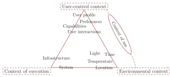
In mobile computing, contextual information can be defined as: Any information that is gathered and can be used to enrich the knowledge about the user’s state, his/her physical surroundings, and capabilities of his/her mobile device(s) [Dey and Abowd, 1999; Schmidt et al.,1999]. Context varies according to application constraints, and by taking into account the way users act in the environment, as well as the interfaces to interact with. Two generic concepts with three main categories have been introduced as super-classes that encapsulate contextual dimensions [Satyanarayanan, 2001; Baldauf et al.,2007;Petit,2010] - Figure 1.1:
• The context of use includes two main categories:
(1) user-centred dimensions of context such as the user profile, his/her preferences as well
1Lifelogging services keep a complete record of users’ day-to-day activities (i.e., lifestream), thanks to small wearable gadgets or computers that captures large chunks of the user’s daily life.
User-centred context
Context of execution Environmental context
Temperature Preferences Time Location Infrastructure System Capabilities User interactions Light User profile Con tex t of us e
Figure 1.1: Classification of contextual dimensions
as his/her physical/cognitive capability, and the user-system interactions (i.e., input data manipulation through the user interface and output communication operations).
(2) the environmental context which refers to the parameters that influence the user (e.g., location, time, temperature, light, etc.).
• The context of execution models the behaviour of an information system and encompasses: (i) the infrastructure dimension and the topological distribution of the system components and (ii) the system dimension that evaluates resource utilization (e.g., memory, processor and network) of the system components and capabilities of the user’s mobile device(s).
This chapter first discusses service-oriented and efficiency-related requirements in order (1) to reconsider current indoor spatial data models from a context-aware systems perspective so that a reference data model can be proposed; (2) to take into consideration dynamic properties and activity-oriented interactions of moving objects with their physical surroundings, and (3) to examine the role played by smart devices and ubiquitous positioning sensors. Secondly, the need for an adaptive query processing paradigm as well as for new ways to express and evaluate continuous location-dependent queries in indoor environments is highlighted.
1.2
Challenges in context-dependent indoor data models
Whether location information should be handled as any other contextual information or managed differently is a key issue. A better understanding of location information and the relationships that might exist among spatial entities, either acting or located in the environment, should be taken into account. Therefore, the integration of an indoor spatial data model into a context-aware system is
considered as a key building block for designing advanced navigation services.
This section presents a classification of the requirements needed to design a context-dependent spatial model into two categories [Afyouni et al., 2012]: service-oriented and efficiency-related requirements. The first group supports real-time and delayed services, and includes: (i) localisa-tion, (ii) navigalocalisa-tion, (iii) location-aware communicalocalisa-tion, (iv) activity-oriented interaclocalisa-tion, and (v) simulation and behavioural analyses. The second group examines efficiency issues and includes: (i) modelling effort, (ii) flexibility, and (iii) performance and scalability. Those are generic and application-independent requirements for the development of a reference spatial data model, and are hereafter used to assess existing approaches.
1.2.1 Service-oriented requirements
A context-dependent spatial model is assumed to represent the locations of objects of interest appropriately, and with additional semantic descriptions so that advanced services can be provided. It also needs to support navigational services a user is likely to ask. Potential communication between located entities should also be supplied. Moreover, a user navigating an indoor space should be able to interact with his/her physical surroundings. Other deferred services can also be offered by the model thus enabling a better understanding of users’ behaviours.
1.2.1.1 Localisation
Several studies have been performed in order to design and build positioning systems in GPS-less indoor environments [Kolodziej and Hjelm, 2006]. Indeed, indoor spaces are constrained by the architectural components such as doors, floors, corridors, and walls. On the one hand, these constrained environments provide meaningful location information at the logical and topological levels, but on the other hand, the task of achieving accurate localisation is not always straightforward.
Spatial data representation
Two different representations of location information can be delivered according to either a geometric or a symbolic representation of space:
• Geometric information gives a quantitative representation of moving objects in the form of coordinates (e.g., Cartesian or latitude-longitude-altitude) that are delivered according to a
given coordinate system. Whereas systems like Global Positioning System (GPS), used outdoors, provides geometric coordinates with respect to a global reference system, others such as the Active Bat system [Ward et al.,1997] and MIT Cricket [Priyantha et al.,2000] use ultrasonic technology and provide three-dimensional positions with respect to local coordinate systems. Those are developed based on a set of local landmarks (e.g., beacons) that are distributed in an indoor space. Topological relationships like “overlap”, “inside”, “intersect”, and “disjoint” can be inferred, thus enabling an interpretation at a higher level of abstraction. As an example of overlapping relationships, floors can be shared between several wings within a building. In such a situation, floors overlap with wings, while a room may belong to a floor and a wing.
• Symbolic information provides qualitative human-readable descriptions about moving objects based on structural entities and/or points of interest (e.g., room or floor identifier, building name, etc.). For instance, the Active Badge system handles values that represent the symbolic identifiers of fixed IR sensors [Want et al.,1992]. In contrast to geometric information, symbolic descriptions allow to explicitly model topological relations (e.g., spatial containment) between entities in the environment. This can be done by means of symbolic spatial models such as set-based or graph-based models (see Chapter 2). Symbolic descriptions enable spatial and semantic reasoning at an abstract level, thus favouring interaction between spatial entities and within space.
Sensor-based positioning
Nowadays, the techniques currently available for indoor positioning range from radio-based technologies (WLAN, RFID, and Bluetooth) to non-radio technologies (Infrared and Ultrasound) to inertial navigation systems (INS) [Kolodziej and Hjelm, 2006]. One challenge for all these techniques is to achieve a precise positioning of a given mobile user, together with some context-aware data that integrate the location of predefined sensors, and more important, a sense of the environment in which users are acting. This leads us to not only locate the users in the environment, but also the sensors available, and the spatial structures underneath. As these systems should be real-time based, in order to take into account the fact that mobile users behave in the environment, there is a general agreement on the fact that there is so far no perfect technique which is capable of reaching the desired accuracy continuously.
Recent approaches have adopted a hybrid approach combining several positioning technologies. For instance,Ray et al. [2010] proposed an infrastructure-less positioning system for both indoor and outdoor environments. This system combines GPS receivers with inertial sensors (MEMS) and an indoor map-matching algorithm. The interest of MEMS sensors is that they usually provide acceleration and angular velocity. The principle behind this approach is that user location data
have to be provided by the sensors continuously. When GPS data are not available, this being the common case in indoor environments, inertial sensors give alternative location data. However, inertial sensors are error-prone that causes sharp performance degradation. This implies to integrate additional rectification processes.
Similar techniques have been introduced elsewhere still for the design of ubiquitous location-based systems. In particular, when using WLAN or RFID positioning techniques, an integrated approach combines one (or both) of them with an inertial navigation system (INS) [Evennou and Marx,2006; Fu and Retscher, 2009]. On the one hand, INS helps to overcome the lack of coverage of radio-frequency (RF) signals when an insufficient number of WLAN antennas or active RFID tags are deployed in an indoor environment. On the other hand, when both technologies (INS/Wi-Fi or INS/RFID) are available, a more precise position measurement can be produced by applying an appropriate multi-sensor data fusion technique [Retscher and Fu,2007]. Therefore, appropriate multi-sensor data fusion techniques and map matching algorithms need to be used in the filtering process [Ray et al.,2010].
Consequently, a spatial model should be capable of representing the coordinate system by which the location information is expressed and, when necessary, transforming that location information in order to get all sensor data in a common format.
1.2.1.2 Context-aware, adaptive navigation
Navigation in an environment can be defined as a scheduled and goal-oriented movement made by humans or robots [Montello, 2005]. While navigating, a user may be technically assisted by sensory devices embedded in the environment that provide relevant information to maintain orientation, and other suggestions to encourage him or her to interact within the environment.
As an extension of typical navigation tasks, contextual dimensions need to be integrated into querying tasks, thus offering opportunities to develop advanced services. A context-aware navigation task is carried out in two phases [Champandard,2003]: the static phase, which is generally known as “path planning”, encompasses a multi-criteria path selection process that generates an unbroken path from the current location to the destination. This process is context-sensitive as it aggregates multiple criteria (e.g., user preferences and capabilities, distance, time, etc.) passed as function parameters to evaluate the cost value of each step and then to select the most appropriate path, that is, the optimal path that allows, for instance, to reach a destination while avoiding threats [Disser et al., 2008]. The dynamic phase lies in a dynamic framework that implements event-triggered controllers needed to monitor the user’s progression in order to avoid deviations from the planned
path.
Although very few works have discussed the integration of such a dynamic framework, researchers agree on some general requirements [Delling et al.,2009]. First, this framework should comprise a next-step selection algorithm that keeps continuous track of the user’s position and tries to recover from deviations by providing additional information. Secondly, the framework should adapt the predetermined path if it detects any significant event that may affect the user’s movement. In such a situation, a path to the nearest emergency exit should, for instance, be recomputed. Recent studies have proposed algorithms for shortest and/or fastest path searches with improved tracking strategies [Berger et al.,2010; Sun et al., 2009; Xu et al., 2010]. The main focus of these algorithms is to keep real-time tracking of moving objects. However, each of them deals with either time or distance constraints without incorporating other elements such as user preferences or events that may significantly influence the answer.
1.2.1.3 Location-aware communication
In contrast to internet telecommunications which enable communication between computing devices based on IP or MAC addresses, communication among objects in smart environments is often based on their location [Beigl et al.,2002]. Location-aware communication models in distributed systems can be classified according to who initiates information exchange and how information is then forwarded to the specified receiver [Aitenbichler,2008]. One can make a distinction between direct (i.e., point-to-point) and indirect communications [Baldoni and Virgillito, 2005]. As an example of indirect communication, a provider can disseminate information about events to invoke remote callback methods from potential subscribers. Similarly, a consumer can request information from a known (i.e., direct message exchange) or anonymous (i.e., indirect message exchange) provider. Moreover, collaborative activities can take place between communicating objects working together to achieve some common goals.
Although spatial models do not affect users’ physical abilities to communicate, the selection of a specific spatial model has a direct effect on the quality and format of data exchanged between users and other entities located in space. Moreover, the way a user perceives its ability to communicate with other entities may be significantly disturbed due to inadequate representation of space. For instance, a fined-grained model can represent a sensor range more accurately than a coarse representation of space. Thus, the user can be aware of the exact communication range for a given sensor.
A dynamic and symbolic location model that supports location-aware communication among rigid entities (i.e., sensors and users) in smart spaces has been suggested inSatoh[2007], which gives
an example of what can be achieved. Rigid entities and places are represented as components in a hierarchy of symbolic labels (i.e., user-room-floor-building hierarchy) based on the containment relationship. Each component in the hierarchy can act as a service provider, a service consumer or both. Different types of communication can then be established between these components depending on their location in the hierarchy. An example of the dynamicity of this model might be the case where users navigate between places (e.g., rooms). A component migration mechanism is then used to update the hierarchical structure of the components and thus keeps track of users’ movements. Two types of communication are then established between these components depending on their location: vertical communication that supports the publish/subscribe approach; this means that events are published by parent components to address their children. Child components that are interested in those events need to be subscribed so that they can receive runtime notifications. Horizontal communication encompasses communication between same-level components of the hierarchy (i.e., components that belong to the same parent in the hierarchy). As an example, interactions between a user and its computing devices (e.g., stationary computer) within a room can be represented, both considered as components that are contained in a parent component which is, in this case, the room.
1.2.1.4 Activity-oriented interactions
A context-dependent model should also support human activities with the aim at achieving some objectives. An activity can be defined as a collection of goal-oriented and context-dependent actions an entity can perform [Kofod-petersen and Cassens,2006;Wu and Fan,2009]. Actions comprise a sequence of location movements, interactions with other neighbouring entities and artefacts, and requests for some services in order to achieve a predefined goal. An activity can also be made of a set of primitive activities or be part of a larger collective activity [Christensen and Bardram,2002]. Activity theory has focused attention on the usefulness of spatial models in the design process to enrich consciousness and interaction within space [Kaptelinin and Nardi,2009;Nardi,1996].
The number of artefacts has increased and been distributed into ubiquitous environments. Artefacts can be physical (e.g., chair, door, heating, etc.) or virtual (e.g., 2D/3D image of a physical artefact, digital user interface, recommendation/information, etc.) [Pederson, 1999]. Physical artefacts can also be augmented with various kinds of sensors or tags (e.g., RFID) so that they can perceive the environment and provide additional information [Rivera et al.,2011]. Those are referred to as digital or sentient artefacts [Beigl et al.,2002;Kawsar et al.,2007]. Spatial representations serve as a mediator to relay relevant information to humans about artefacts in their surrounding. This allows users, who are engaged in a certain activity, for both collecting knowledge and understanding physical surroundings, and furthermore, for reconfiguring and manipulating physical/virtual artefacts
to anticipate or produce changes in the environment. Consequently, embodied interaction defined by [Dourish, 2004] can take place by means of spatial reconfigurations that may influence the context by affecting existing activities and/or initiating new ones. A main challenge that designers face and should consider is to efficiently represent artefacts of interest located in the environment. Unfortunately, most of existing indoor spatial models are not designed for that purpose and thus do not supply interaction with these artefacts and the tasks they might participate in.
1.2.1.5 Spatial & behavioural analyses
An essential issue in the development of analyses and simulations lies in identifying an appropriate spatial representation with respect to the phenomenon or behaviour being explored. Several typical scenarios for planning purposes are introduced in [Li et al.,2010]. These scenarios present application-dependent constraints, so each of them needs an appropriate level of granularity. Some examples of spatial analyses and scenarios applied on a fine-grained spatial model are [Li et al.,2010]:
• Route analysis scenarios that aim at finding shortest paths between two given locations or all pairs shortest paths applied on a given floor architecture and with a given data structure [Werner et al.,2000;Zhang et al.,2011].
• Diffusion analysis defined as a dynamic process where the spatio-temporal evolution and extent of a phenomenon within an indoor space are explored [Batty et al.,1999].
• Centrality measures that characterize the architectural design and the spatial distribution of objects of interest in a built environment [Bonacich,1987], and are largely applied by space syntax studies [Jiang and Claramunt,2004;Kim and Jun,2008;Kostakos,2009].
The granularity parameter is an important aspect of these analyses that enables the exploration and understanding of spatial data. A fine granularity can certainly reflect the indoor space delicately, and is especially needed when simulating a physical process or when considering fine-grained tracking of human mobility to get accurate understanding of the environment. In contrast, topological analyses often require a coarser granularity to support adjacency and connectivity relations between spatial units (e.g., room), and thus deriving a more abstract view of the topology of a complex indoor space. In particular, topological analyses have been largely developed and applied by space syntax studies to evaluate human-environment interactions and to examine different spatial and structural configurations [Jiang and Claramunt,2000;Turner and Penn,2002].
Behavioural analyses are, on the other hand, of special interest in context-aware computing, and have been recently developed in numerous fields for activity-recognition purposes [Albinali,2008].
Activity-recognition systems can support different application scenarios in many areas including safety control, medical healthcare, and other monitoring activities in virtual environments that aim at customizing the system to end-users’ situation or context [Bardram,2005;Christensen and Bardram, 2002]. This helps, for instance, to reduce occurrence of hazardous situations by monitoring and correcting human error during the execution of critical tasks (e.g., administering medication in healthcare, ensuring proper execution of tasks in safety applications) or to exploit user interactions with an application (e.g., mouse clicks) to infer his/her activities as suggested in [Albinali and Gniady,
2006]. Moreover, knowing the locations and preferences of the users in an indoor context-aware navigation system can lead to optimise the knowledge about the user’s behaviour in the considered scenario (e.g., inferring the most bought products in a supermarket by the loyal users) [Porros Pérez et al., 2011]. Activity monitoring combined with the delivery of behaviour-related context-aware reminders for elderly persons have been also discussed in [Zhang et al.,2011].
1.2.2 Efficiency-related requirements
An offline requirement regarding the modelling effort needs to be considered in the evaluation process. A spatial model should also be flexible as much as possible so that a wide range of applications can be applied. Efficiency is closely related to the performance and scalability of the system being developed. Those requirements are discussed in the following subsections.
1.2.2.1 Modelling effort
The modelling effort can be evaluated by the cost and complexity of the model design effort. Some modelling techniques are sophisticated and take considerable effort [Thrun, 2003]. Some others are closely dependent on objects within space and need to be periodically maintained or even to be rebuilt from scratch if these objects change their position or shape. Recently, some authors have discussed several methods for automated construction that minimize manual intervention by designers during the modelling phase [Stoffel,2009].
1.2.2.2 Flexibility
A flexible spatial model should support a large spectrum of applications that can be developed at different levels of abstraction, as well as different kinds of positioning sensors that might coexist to achieve better accuracy. This enables human reasoning about space, robot-based activities, and even sensor-based and object-oriented interactions within the environment. In brief, may a simple unmixed spatial model assist and deal with a very diverse intelligent navigation tasks efficiently? As
will be shown later (cf. Section2.3), it might be difficult to find a single solution that meets these seemingly contradictory requirements. Consequently, we propose to assess current models based on the range of queries and services that can be supported.
1.2.2.3 Performance and scalability
A context-aware indoor navigation system requires to efficiently execute users’ queries such as shortest paths between two given locations, k-nearest neighbour objects or all accessible locations starting from their current position [Lyardet et al., 2008]. When considering contextual information, performance is no longer restricted to simply deriving position queries or distance functions, but some other functionalities are required, thus leading to a significant increase in workload. Furthermore, dynamic updates of the spatial data model stored on mobile devices should be periodically performed in order to maintain accuracy and quality of the stored data. For instance, one challenge facing spatial model designers is the cost of updating the location of every moving object continuously. Existing approaches try to overcome this problem by performing periodic, deferred (i.e., demand-based) or immediate (i.e., event-driven) update queries to keep an incremental view maintenance of the database [Iwerks,2004].
A related approach focuses on real-time map updates on mobile devices by considering the use of a spatial model with different levels of detail [Kang et al.,2007]. Updates in this approach are handled at the basic level on the server side, and then an update propagation process through the other levels of the spatial model is continuously performed at the client side. This framework considers the use of a spatial model with different levels of detail. Hence, it first handles updates at the basic level on the server side, and then manages the update propagation process through the other description levels of the spatial model. Further, it transfers update messages that contain updated spatial objects to subscribed clients thus replacing original objects with matching identifiers.
The scalability requirement denotes the ability of a spatial model to scale up to a large indoor environment while keeping tolerable resource consumption, which mainly affects the memory storage capacity and the behaviour of processing workloads. In context-aware applications, heterogeneous mobile devices as well as a huge number of embedded sensors have to be handled in an efficient and scalable way. Therefore, there is a need to establish a mechanism that eliminates superfluous information to reduce processing and communication costs, so that the system can handle a higher number of real-time queries.

![Figure 2.3: A generalised Voronoi diagram of an indoor space [Wallgrun, 2005]](https://thumb-eu.123doks.com/thumbv2/123doknet/14589397.729969/65.892.260.572.186.489/figure-generalised-voronoi-diagram-indoor-space-wallgrun.webp)

![Table 3.1: Cooperation from moving objects [Adapted from [Ilarri et al., 2010]]](https://thumb-eu.123doks.com/thumbv2/123doknet/14589397.729969/86.892.128.825.182.507/table-cooperation-moving-objects-adapted-ilarri-et-al.webp)
