HAL Id: hal-00297380
https://hal.archives-ouvertes.fr/hal-00297380
Submitted on 13 Apr 2005
HAL is a multi-disciplinary open access
archive for the deposit and dissemination of
sci-entific research documents, whether they are
pub-lished or not. The documents may come from
teaching and research institutions in France or
abroad, or from public or private research centers.
L’archive ouverte pluridisciplinaire HAL, est
destinée au dépôt et à la diffusion de documents
scientifiques de niveau recherche, publiés ou non,
émanant des établissements d’enseignement et de
recherche français ou étrangers, des laboratoires
publics ou privés.
Geomorphological features and monitoring of a large
and complex landslide near Avigliano urban area (South
Italy)
F. Sdao, S. Pascale, P. Rutigliano
To cite this version:
F. Sdao, S. Pascale, P. Rutigliano. Geomorphological features and monitoring of a large and complex
landslide near Avigliano urban area (South Italy). Advances in Geosciences, European Geosciences
Union, 2005, 2, pp.97-101. �hal-00297380�
SRef-ID: 1680-7359/adgeo/2005-2-97 European Geosciences Union
© 2005 Author(s). This work is licensed under a Creative Commons License.
Advances in
Geosciences
Geomorphological features and monitoring of a large and complex
landslide near Avigliano urban area (South Italy)
F. Sdao1, S. Pascale1, and P. Rutigliano2
1Universit`a degli Studi della Basilicata, CIMA, Centro Interuniversitario Monitoraggio Ambientale, Italy 2Telespazio Spa, Centro di Geodesia Spaziale “G. Colombo”, Matera, Italy
Received: 19 October 2004 – Revised: 10 February 2005 – Accepted: 16 February 2005 – Published: 13 April 2005
Abstract. This paper reports the results of geological and
geomorphological surveys and the first results of a still in progress GPS monitoring campaign1, taken on a large and ancient landslide located near Avigliano town (Basilicata re-gion, South Italy). The landslide occurs on structurally com-plex clayey-marly terrains and it is classifiable as a multiple and complex roto-translational-earthflow landslide. In the last years this landslide has been affected by frequent reac-tivations that have been the cause of grave damages to the urban structures in the area. During January 2004, in order to monitor the present kinematics of the landslide body, a GPS network was installed. Until today several GPS surveys have been carried out. The results of GPS data analysis show centimetres level motions going on the landslide. The final goal of the research will be to define a hazard evaluation and an evolution model of the landslide, using the integrated in-formation coming from GPS and geomorphological surveys.
1 Introduction
In the following are reported the results of geological and ge-omorphological surveys and the first results of a GPS mon-itoring campaign on the La Braita landslide (Fig. 1), lo-cated near Avigliano town (Basilicata region, South Italy). The landslide, occurring on structurally complex clayey-marly terrains, is classifiable as a multiple and complex roto-translational landslide, which somewhere evolves into earth-flow. In the last years this landslide has been affected by fre-quent reactivations that have been the cause of large damages to the urban structures present in the area. To obtain a bet-ter characbet-terization of the geological and geomorphological features of the landslide, careful geo-morphological survey has been carried out and integrated with the interpretation of
Correspondence to: F. Sdao
(sdao@unibas.it)
1The GPS activities have been carried out under Agenzia
Spaziale Italiana (ASI) Contract N. I/011/03/0
aerial photos taken at different scales. The results of these in-vestigations brought us to define the better location for some GPS stations and on January 2004 a six markers local GPS network was installed.
This network has been periodically surveyed to investi-gate the landslide displacements. The GPS measures allow to detect both the “absolute” motion of the phenomena and the ”relative” motion of different areas of the landslide. All the GPS measurements taken from this local network are re-ferred to a marker located in a stable area. The stability of the position of the reference point has been verified at each campaign of measurement computing his coordinates as a point of a wider GPS network based also on stations belong-ing to the Italian National GPS Network of the Italian Space Agency (ASI).
2 Geological setting
The whole territory of Basilicata region is affected by ex-tensive landslide phenomena strictly related to climatic, ge-ological and geomorphge-ological factors. Often the landslides phenomena are reactivated after the rainfall periods, caus-ing severe damages to urban structures (Polemio and Sdao, 1996; Polemio and Sdao, 1998; Polemio and Sdao, 1999). Avigliano urban area and the surrounding areas are heav-ily affected by landslides as testified by the occurrence of huge landslide deposits shown in Fig. 1. In this area a Middle Pliocene conglomerate-sandy formation (Unit of Ar-iano) outcrops diffusely. This Unit overlies the flysch ter-rains, belonging to Varicoloured Clays (Upper Cretaceous-Oligocene) and Flysch Rosso (Upper Cretaceous-Cretaceous-Oligocene) Units (Pescatore et al., 1988; Polemio and Sdao, 1999). Some alluvial deposits are in the south-western part of the study area, along the La Braita river.
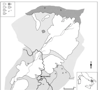
98 F. Sdao et al.: Geomorphological features and monitoring of a large landslide 8 5° 40° 37° 38° 38° 20° 20° 40° 43° 20° 30° 50° 60° 917 985 AVIGLIANO N 1 2 3 4 5 6 7 o 500 m
Figure 1 - Geological sketch-map of the area: 1) Landslide bodies; 2) Alluvial deposits; 3) Sandy formation (Middle Pliocene); 4) Conglomerate formation (Middle Pliocene); 5) Flysch Rosso (Upper Cretaceous – Oligocene); 6) Varicoloured Clays (Upper Cretaceous – Oligocene); 7) Attitude of strata.
Fig. 1. Geological sketch-map of the area: 1) Landslide bodies; 2)
Alluvial deposits; 3) Sandy formation (Middle Pliocene); 4) Con-glomerate formation (Middle Pliocene); 5) Flysch Rosso (Upper Cretaceous – Oligocene); 6) Varicoloured Clays (Upper Cretaceous – Oligocene); 7) Attitude of strata.
9 917 985 N 1288,4 1035,2 846,7 1128,7 1195,3 1 2 3 4 5 a b 6 o 500 m
Figure 2 - Geomorphological sketch-map of La Braida landslide: 1) Main scarp of landslide,
(broken line where degraded); 2) Boundary of the landslide body (broken line where degraded); 3) Roto-translational slides (a) and earthflows (b); 4) Intense creeping processes; 5) trench; 6) Active landslide body subject to GPS monitoring.
Fig. 2. Geomorphological sketch-map of La Braida landslide: 1)
Main scarp of landslide, (broken line where degraded); 2) Bound-ary of the landslide body (broken line where degraded); 3) Roto-translational slides (a) and earthflows (b); 4) Intense creeping pro-cesses; 5) trench; 6) Active landslide body subject to GPS monitor-ing.
3 Landslide analysis
The La Braita landslide is more than 2000 m long, 200– 300 m wide and 30 m thick in its deepest sector. This land-slide is a part of a bigger landland-slide, located in the north-western sector of the Avigliano territory (Fig. 2). The geo-morphological sketch of the landslide is shown in Fig. 2; the landslide occurs on structurally complex clayey-marly ter-rains (Varicoloured Clays Unit) and it is classifiable as a mul-tiple and complex rotational-translational phenomena. The terrains of the Varicoloured Clays Unit are classifiable as se-quence of clays and clayey-marly terrains with centimetres-to-decimetres-thick calcareous layers and blocks.
As mentioned above, in the last years La Braita landslide has been affected by several reactivations that caused seri-ous damages to the urban structures. The principal reacti-vations of the mass movements have been observed during the winter seasons of 1950 and of 1961, and during February 1981 and December 1997. In particular, the landslide reacti-vation occurred in February 1981 caused several damage to urban structures and to the connection roads (Calcagnile et al., 1983). From February 1981 to November 1997, no de-tectable motions were observed. At the end of November 1997 there was a reactivation of the phenomena, with im-portant displacements localized in the high and middle part of the landslide body (Fig. 2). This reactivation generated a huge upheaval on the road that connects the Pantani village with the town of Avigliano, it destroyed a bridge and inter-rupted the drinking water aqueduct.
After this event, a campaign of investigation on the land-slide was planned by the Basilicata Region Geological Sur-vey; detailed geological surveys and several mechanical boreholes were carried out in the urban area of Pantani (for location see Fig. 3). The obtained results showed that the landslide reactivation affected the high and middle part of the ancient mudflow body for a length of 2600 m and a width of 100–150 m, while the thickness of remobilised material was about 10–30 m (Fig. 3, boreholes Si4, Si5, Si6). Since this period no more systematic investigation has been conducted in this area.
In the last months, we started a new campaign of investi-gation on the landslide. The first step has been the analysis of several aerial photos obtained at different scales (1:10 000, 1:33 000) and a new analysis of the stratigraphy obtained by the drilling survey carried out in 1997. The collected infor-mation together with the results coming from the new geo-morphological survey, allows us to obtain a better definition of the geological and geomorphological features of the land-slide; some reconstructions are shown in Figs. 3 and 4. Along the main body of the landslide there are several secondary scarps, morphological depressions, surface land sliding and creeping evidences. The highest part of the landslide body, located at an altitude ranging from 1175 to 1125 m a.s.l., is characterized by some evidence of a roto-translational move-ments that involves a large volume of terrain, 400–500 m long, 1400–1500 m wide and 30 m thick in its central part.
10
1200 m
900 m
500 m
PANTANI VALLE SAN VITO
BRAIDA RIVER
Si6 Si4Si5
S1 S3 S2 Si1 (a), S1 (b) 100 m 100 m 1 2 3 4 5 6 7 8
Figure 3
-Geomorphological section: 1) Landslide body reactivated in 1997; 2)Ancient
landslide body; 3) Alluvial deposits; 4) Ariano Unit (Middle Pliocene); 5) Varicoloured Clays
(Upper Cretaceous – Oligocene); 6) Sliding surface of the 1997 landslide; 7) Sliding surface
of the ancient landslide; 8) Boreholes; (a) with inclinometer.
1 2 3 M1
M0
M1
M2
M3
M4
M5
o 500 m NFigure 4 – Particular from the Figure 2 showing both the main geomorphological features of
the examined landslide and GPS network: 1) Main scarp of landslide; 2) Boundary of the
landslide body; 3) The points M0 – M5 show the position of GPS network.
Fig. 3. Geomorphological section: 1) Landslide body reactivated in 1997; 2)Ancient landslide body; 3) Alluvial deposits; 4) Ariano Unit
(Middle Pliocene); 5) Varicoloured Clays (Upper Cretaceous – Oligocene); 6) Sliding surface of the 1997 landslide; 7) Sliding surface of the ancient landslide; 8) Boreholes; (a) with inclinometer.
In the lowest part, located at an altitude ranging from 1050 to 1025 m a.s.l., a wide counter-sloping landslide terrace can be observed. A large ancient mudflow begins from the base of this terrace and it extends down-slope so much and par-tially fills the bed of La Braita river. The mudflow body is 3800 m long, up to 400 m wide and 30–40 m tick, as esti-mated by geognostic and geophysical surveys (Calcagnile et al., 1983).
At present time, the landslide does not seem affected by generalized mass movements, even though, some evidences of activities are quite visible in the same areas involved in the reactivation of 1997. During January 2004, in order to monitor the present kinematics of the landslide body, a GPS network was installed.
4 GPS network
The GPS network is made up of six stations of measurement placed along the landslide; the positions of the measurement GPS points are shown in Fig. 4. In each monitoring point a marker allowing a forced centring of the antenna mount was installed. The forced centring device is useful in order to avoid any error due to the re-positioning of GPS antenna in the different session of measurement. Starting from February 2004, the GPS measurements are carried out periodically, on a monthly basis interval. Each session of measure is about 6 h long. Particular attention is paid to the geo-location and to the accurate monitoring of stability of the reference point of the network (point M0 in Fig. 4), the point with respect to all others GPS measurements are referred. The reference point of the network was placed in a stable area, in the highest part of the investigated area, on a structure, that was built up as a part of the reclamation work made in the area. Another
10 1200 m
900 m
500 m
PANTANI VALLE SAN VITO
BRAIDA RIVER
Si6 Si4Si5 S1 S2S3
Si1 (a), S1 (b)
100 m
100 m 1 2 3 4 5
6 7 8
Figure 3 - Geomorphological section: 1) Landslide body reactivated in 1997; 2)Ancient
landslide body; 3) Alluvial deposits; 4) Ariano Unit (Middle Pliocene); 5) Varicoloured Clays (Upper Cretaceous – Oligocene); 6) Sliding surface of the 1997 landslide; 7) Sliding surface of the ancient landslide; 8) Boreholes; (a) with inclinometer.
1 2 3 M1 M0 M1 M2 M3 M4 M5 o 500 m N
Figure 4 – Particular from the Figure 2 showing both the main geomorphological features of the examined landslide and GPS network: 1) Main scarp of landslide; 2) Boundary of the landslide body; 3) The points M0 – M5 show the position of GPS network.
Fig. 4. Particular from the Fig. 2 showing both the main
geomor-phological features of the examined landslide and GPS network: 1) Main scarp of landslide; 2) Boundary of the landslide body; 3) The points M0 – M5 show the position of GPS network.
GPS station (point M1 in Fig. 4) was placed on a structure, built up to avoid more damages to a connection road that is located along the flanks of the valley interested by landslide motions. The data collected by this station are useful to ver-ify the stability of this structure. The other GPS points of measurements were placed on the outcropping rock blocks of the landslide deposits; the only exception was point M4 placed on the ruins of a large bridge, cut-off by the land-slide. This point was placed on this big structure, under the assumption that, a clear evidence of movement of the point means a large mass movement.
100 F. Sdao et al.: Geomorphological features and monitoring of a large landslide
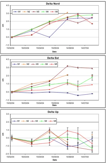
11 Figure 5 - GPS results. All the values are reported in terms of Delta North, East and UP as residuals with respect to the “zero measurement”. The points M2 and M3 seem to show some displacement, that, at present time, could be considered as local displacement.
Delta Nord -1.0 0.0 1.0 2.0 3.0 4.0 15/02/04 16/03/04 15/04/04 15/05/04 14/06/04 14/07/04 Date cm M1 M2 M3 M4 M5 Delta Est -1.0 0.0 1.0 2.0 3.0 4.0 15/02/04 16/03/04 15/04/04 15/05/04 14/06/04 14/07/04 Date cm M1 M2 M3 M4 M5 Delta Up -2.0 -1.0 0.0 1.0 2.0 3.0 15/02/04 16/03/04 15/04/04 15/05/04 14/06/04 14/07/04 Date cm M1 M2 M3 M4 M5
Fig. 5. GPS results. All the values are reported in terms of Delta
North, East and UP as residuals with respect to the “zero measure-ment”. The points M2 and M3 seem to show some displacement, that, at present time, could be considered as local displacement.
4.1 GPS analysis procedure
As stated above, the reference point of the GPS network (point M0) was placed in a deemed area. In order to ob-tain the precise coordinates of this point and to verify the real stability of this area, the data acquired at M0 GPS sta-tion in each survey, were analyzed as part of a wide network which includes also the GPS stations of Elba, Matera, Noto and Cagliari. All these stations are CORS station of the GPS Italian National Reference Network managed by ASI. In each solution, the coordinates of Matera station were kept fixed to obtain all the solution in the same reference system (ITRF2000).
For each solution, the estimated coordinates of Elba, Noto and Cagliari were compared with their respective values pro-duced by the EPN (European Reference Permanent Net-work). Millimetre residuals were found in each solution. This comparison was made as a further check of the esti-mated coordinates and the results confirmed the goodness of the analysis procedures.
4.2 GPS results
Figure 5 shows the results coming from the analysis of the available data in terms of Delta North, Delta East and Delta Up component of motion. The values Delta North, Delta East and Delta Up are the vector components of the base-line calculated between each station of measurement and the reference point. The directions of motion (North, East, Up) are referred to a local reference system. The values shown in Fig. 5 are residuals calculated for each point as the difference between the coordinates estimated with the data from the first measurement campaign (January 2004) and each other sub-sequent campaign.
The analysis of the coordinate time series of the M0 point shows that the GPS data collected at this site are quite noisy. The statistic repeatability of the horizontal coordinates of the reference station is in the order of about 2 centimetres, while the vertical component is affected by a statistical error of about 3 centimetres. Taking into account this information in the interpretation of the results, only displacements of several centimetres could be considered really indicative of landslide motion. Moreover in the interpretation of the results we must pay attention to the possibility of local displacement around the marker points, displacement that could be cause of mis-interpretation of the results.
The magnitude of the displacements, observed in the pe-riod from January to July 2004, shows motions in the order of few centimetres, so there are no evidence of large mass movements, in agreement with the results of geomorpholgi-cal surveys. This means that, in the period under investiga-tion, the landslide has been substantially still, but these re-sults could be indicative of resumption of the landslide evo-lution.
Looking at the results, all points show detectable motions in the horizontal component, more evident in the North direc-tion rather than in the East one. There is no clear evidence of motions in the vertical (Up) component. As stated before the M1 station (Fig. 4) is located on an artificial structure built up to control the landslide phenomena; the motions observed could be representative of assessment of the structure due to small movements of the terrain. M2 and M3 stations, located in sites potentially unstable (in particular the point M3) show some displacements in the period from January to June; the July last results show no more motions in these two sites. The results from point M4 (as stated before placed on the ruins of a bridge), show no evidence of relevant displacements. This strengthens the hypothesis that there are no large movements in act along the landslide at present time.
4.3 Future works
The GPS surveys will continue on a monthly basis. In order to obtain more information about the Avigliano landslide, we are planning a kinematics GPS campaign to obtain a Digital Terrain Model (DTM) of the area. The DTM could be very useful as input in modelling the evolution of the landslide. Using the DTM data and the parameters coming from the
planned geological and geomorphological surveys we could be able to define the areas of highest risk in the evolution of the phenomena.
Acknowledgements. The authors would like to acknowledge F.
Vespe of the Italian Space Agency (ASI) and A. Caivano for the helpful discussion. The GPS activities has been carried out under ASI Contract N. I/011/03/0.
Edited by: L. Ferraris
Reviewed by: anonymous referees
References
Calcagnile, G., Canziani, R., Del Gaudio, V., Guerricchio, A., Meli-doro, G. and Ruina, G.: Indagini geologico-geofisiche in alcune aree franose di Avigliano e di Stigliano (Basilicata), Geologia Applicata e Idrogeologia, Vol. XVIII, pp. 117–133, 1983. Pescatore, T., Renda, P., and Tramutoli, M.: Rapporti tra le unit`a
lagonegresi e le unit`a sicilidi nella media valle del Basento (Ap-pennino Lucano), Mem. Soc. Geol. It., 41, 353–361, 1988. Polemio, M. and Sdao, F.: Rischio di frana indotto dagli eventi di
pioggia in Avigliano (Basilicata), Geologia Applicata e Idroge-ologia, Vol. XXXI, 23–30, 1996.
Polemio, M. and Sdao, F.: Heavy rainfalls and extensive landslides occurred in Basilicata, Southern Italy, in 1976, 8th International IAEG Congress, Balkema, Rotterdam, 1998.
Polemio, M. and Sdao, F.: The role of rainfall in the landslide haz-ard: the case of the Avigliano urban area (Southern Apennines, Italy), Engineering Geology, 53, 297–309, 1999.