HAL Id: hal-01814406
https://hal.archives-ouvertes.fr/hal-01814406
Submitted on 28 Jun 2018HAL is a multi-disciplinary open access
archive for the deposit and dissemination of sci-entific research documents, whether they are pub-lished or not. The documents may come from teaching and research institutions in France or abroad, or from public or private research centers.
L’archive ouverte pluridisciplinaire HAL, est destinée au dépôt et à la diffusion de documents scientifiques de niveau recherche, publiés ou non, émanant des établissements d’enseignement et de recherche français ou étrangers, des laboratoires publics ou privés.
Monitoring of a sediment replenishment operation: The
case of the Saint-Sauveur dam in the Buëch River
(Southern Alps, France)
Guillaume Brousse, Mélanie Bertrand, Gilles Arnaud-Fassetta, Frédéric
Liébault, Laurent Borgniet, Gabriel Melun, Remi Loire, Jean-René Malavoi,
Guillaume Fantino
To cite this version:
Guillaume Brousse, Mélanie Bertrand, Gilles Arnaud-Fassetta, Frédéric Liébault, Laurent Borgniet, et al.. Monitoring of a sediment replenishment operation: The case of the Saint-Sauveur dam in the Buëch River (Southern Alps, France). I.S.Rivers 2018 (Integrative sciences and sustainable development of rivers), Jun 2018, Lyon, France. �hal-01814406�
I.S.RIVERS 2018
1
Monitoring of a sediment replenishment operation:
The case of the Saint-Sauveur dam in the Buëch
River (Southern Alps, France)
Suivi d’une opération de réinjection sédimentaire : le cas
du barrage de Saint-Sauveur sur le Buëch (Alpes du
Sud, France)
Guillaume
Brousse
1;
Mélanie
Bertrand
2;
Gilles
Arnaud-Fassetta
1; Frédéric Liébault
2; Laurent Borgniet
3; Gabriel Melun
4;
Remi Loire
5; Jean-René Malavoi
5; Guillaume Fantino
61Université Paris-Diderot (Paris 7), UMR 8586 (PRODIG),
guillaume.brousse@univ-paris-diderot.fr. 2 UGA-IRSTEA-ETNA. 3UGA-IRSTEA-
TE. 4Agence Française pour la Biodiversité, DREC. 5 EDF – DPIH / CIH. 6
GEOPEKA.
RÉSUMÉ
Le barrage de Saint-Sauveur a été construit en 1992 dans la partie médiane du bassin versant du Buëch. En aval du barrage, une incision pluri-métrique du lit est observée. Dans le but de restaurer la bande active et les habitats, environ 44 000 m3 de sédiments ont été excavés dans le remous solide
du barrage puis réinjectés en aval en septembre 2016. Le but de cette étude est de comprendre l’évolution des sédiments réinjectés afin de mesurer 1) l’efficience des travaux de restauration et 2) les bénéfices pour les habitats aquatiques.
Le suivi de la réinjection sédimentaire est fondé sur la combinaison 1) de la détection des changements hydromorphologiques en utilisant des MNT séquentiels haute résolution (issus de données LiDAR et de l’imagerie SfM acquise par drone), 2) du traçage sédimentaire utilisant la technologie RFID-UHF active et 3) de l’acquisition et du traitement de l’analyse de la variabilité morpho-granulométrique des alluvions du lit pour les calculs de transport solide.
Le suivi permet de comprendre l’évolution morphologique dans des conditions hydrologiques variées et dans des contextes de modes de gestion différents (mise en transparence ou non).
ABSTRACT
The Saint-Sauveur dam was built in 1992 in the middle section of the Buëch River. Downstream from the dam, a pluri-metric channel incision is observed. In order to restore active channel and habitats, around 44,000 m3 of gravels were excavated in the proximal part of the reservoir and reinjected
downstream from the dam in September 2016. The aim of this study is to understand the evolution of sediments reinjected in order to measure (i) the efficiency of the restoration works and (ii) gains for aquatic habitats.
The monitoring is based on a combination of (i) change detection using sequential high-resolution DTMs (from airborne LiDAR data and UAV-SfM surveys), (ii) bedload tracing using active RFID technology, and (iii) complementary field surveys of channel grain-size distribution and morphology for bedload transport computation.
Monitoring allow to understand hydromorphological change with varied hydrological conditions and different modes of dam management (hydraulic transparency or not).
KEY WORDS
I.S.RIVERS 2018
2
1
INTRODUCTION
1.1 An altered torrential river
The Buëch is a gravel-bed braided river draining the Southern French Prealps. It is one of the major Alpine tributary to the Durance River. The study reach is located close to the city of Serres, downstream from the EDF dam of Saint-Sauveur. The catchment geology is exclusively composed of sedimentary rocks (marls and limestones). The climate is Mediterranean with heavy rainfalls during autumn, and secondary during spring.
Like most of Alpine braided rivers in France, the Buëch has been highly impacted by intensive gravel mining. Sediment supply has been reduced by reforestation and natural changes. In addition, the bedload transport continuity has been strongly altered by the construction of the Saint-Sauveur dam (Gautier, 1994). According to the ancient dam management, only half of the mean annual bedload yield can pass the dam by flood gates. The only external sediment source along the restored reach is the confluence with the Torrent de Channe, located 2 km downstream from the dam. These human alterations of the sediment regime resulted in important channel responses, like downstream-progressing active channel narrowing and degradation. A shift from a braided to a wandering pattern can be clearly observed along several reaches, including the study reach.
1.2 The restoration project
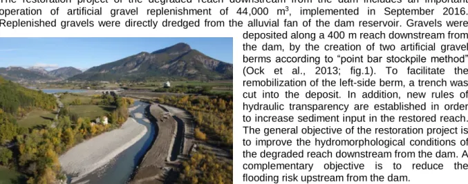
The restoration project of the degraded reach downstream from the dam includes an important operation of artificial gravel replenishment of 44,000 m3, implemented in September 2016.
Replenished gravels were directly dredged from the alluvial fan of the dam reservoir. Gravels were deposited along a 400 m reach downstream from the dam, by the creation of two artificial gravel berms according to “point bar stockpile method” (Ock et al., 2013; fig.1). To facilitate the remobilization of the left-side berm, a trench was cut into the deposit. In addition, new rules of hydraulic transparency are established in order to increase sediment input in the restored reach. The general objective of the restoration project is to improve the hydromorphological conditions of the degraded reach downstream from the dam. A complementary objective is to reduce the flooding risk upstream from the dam.
1.3 Objectives
The main objective of this study is to capture the geomorphic response of the degraded reach to the artificial gravel recharge. The increase of sediment supply is expected to induce a raise of the bed-level and a reactivation of the braiding processes. Theses improved geomorphic conditions should also be favorable in terms of aquatic and terrestrial habitat diversity.
2
METHODS
The physical monitoring combines (i) repetitive high-resolution topographic surveys of the restored reach, (ii) a bedload tracing program using active ultra-high frequency RFID technology, (iii) a high-frequency qualitative survey of channel change using time-lapse cameras, and (iv) ancillary field surveys for specific data analysis (e.g., bedload transport computation, calibration of imagery-based data processing).
3
RESULTS AND DISCUSSION
3.1 Hydromorphological impacts of a ten-year flood (2016-2017)
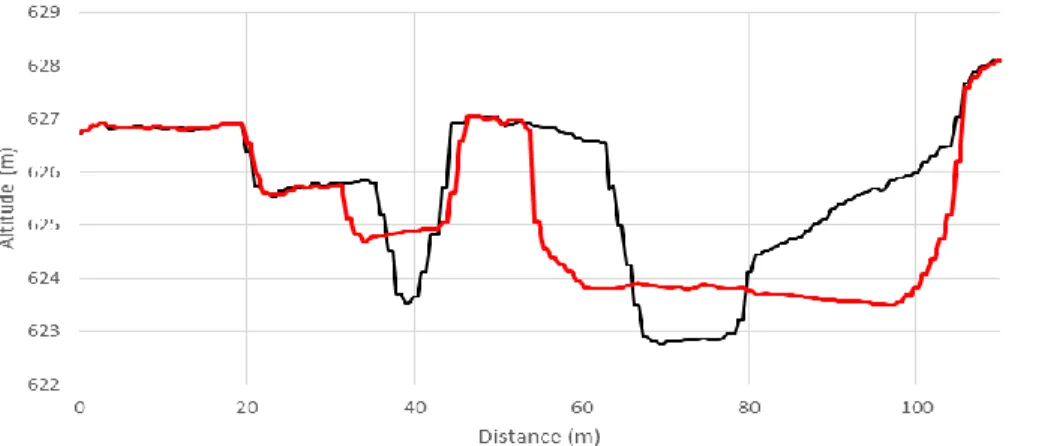
Only three weeks after restoration a ten-year flood allows us to analyze geomorphological change and efficiency of the replenishment operation (Brousse, 2017). This flood with good hydraulic transparency has eroded 47% of the total artificial sediment recharge. Erosion is very important on the right berm
I.S.RIVERS 2018
3
(6100 m3) and on the central berm (13,000 m3) but very low on the left berm (1100 m3, fig.2). The
trench has been strongly shortened (380 m to 198 m). Its relative elevation from the main channel increased and its slope decreased from 0.54 to 0.2%.
Figure 2: Eroded cross section after Q10 flood.
This graph is obtained by DEM differencing (after restoration in black and after flood in red). See the right and central erosion of artificial berms. Left berm was not really eroded because of not flooded surface and low energy in the trench.
At the reach scale, we observed a general aggradation of the bed level with a mean value of 0.3 m. The replenishment reach recorded the maximum bed aggradation (0.81 m) and we observed a downstream thickness gradient with a minimum value close to the end of the study reach (-0.2 m). The bedload continuity principle allows us to quantify the flood sedimentary budget. Sediment storage change along the reach has been calculated by DEM differencing (+25,300 m3). Sediment output has
been calculated by bedload calculations and post flood field data (12,000 m3). Those values allow to
estimated input (37,300 m3). Input correspond to 90% of the mean annual bedload supply upstream of
the dam and 190% of the mean bedload downstream of the dam.
3.2. Physical monitoring perspectives (2017-2019)
The restored reach of the Buëch River will be monitored at least until 2019 using intensive 3D topographic surveys based on both airborne LiDAR data and UAV-SfM imagery. A first UAV survey has been completed in July 2017 and it will be used to assess the morphological evolution of the reach following the spring snowmelt flows of 2017. Two UAV surveys per year (one in early summer, and one in late autumn) will be completed until the end of 2019, as well as one LiDAR survey per year covering a longer channel reach. These intensive repetitive surveys are expected to provide some very high-quality observations about the morphological trajectory of the replenished reach and associated terrestrial and aquatic habitat diversity. This physical monitoring will be also combined with repetitive macroinvertebrate and fish surveys through collaboration with the environmental department of the Conseil Départemental des Hautes-Alpes (Hymocares Interreg Alpine Space project).
4
CONCLUSIONS
Artificial berms have been strongly eroded by a ten-years flood. In association with a good hydraulic transparency, we assist at a very important sediment supply in the restored reach. The replenishment design with artificial berms seems to be a good solution for restoring dam-impacted reaches. Morphological state of the Buëch River is already better after one year of monitoring. Global bed aggradation allows to limiting the bed degradation by overtopping marl outcrops as expected by designers. Morphological conditions are now adequate for braided pattern recovery. But monitoring time is too short to confirm if this trend is sustainable or not. It is necessary to assess on longer time-scale and to compare results with reference station in order to separate natural evolutions and restored gains.
BIBLIOGRAPHY
Brousse, G. (2017). Un an de suivi hydromorphologique sur l'opération de réinjection sédimentaire en aval du barrage de Saint-Sauveur. Acte des journées du GIS Draix-Bléone (IRSTEA) du 22 et 23 juin 2017, Draix, France.
Gautier, E. (1994). Interférence des facteurs anthropiques et naturels dans le processus d'incision sur une rivière alpine - L'exemple du Buëch (Alpes du sud). Revue de géographie de Lyon, vol. 69, n°1.
Ock G., Sumi T., Takemon Y. (2013). Sediment replenishment to downstream reaches below dams: implementation perspectives. Hydrological Research Letters 7(3), 54–59.