HAL Id: hal-00298904
https://hal.archives-ouvertes.fr/hal-00298904
Submitted on 18 Oct 2007HAL is a multi-disciplinary open access
archive for the deposit and dissemination of sci-entific research documents, whether they are pub-lished or not. The documents may come from teaching and research institutions in France or abroad, or from public or private research centers.
L’archive ouverte pluridisciplinaire HAL, est destinée au dépôt et à la diffusion de documents scientifiques de niveau recherche, publiés ou non, émanant des établissements d’enseignement et de recherche français ou étrangers, des laboratoires publics ou privés.
Floodplain sediment from a 30-year-recurrence flood in
2005 of the Ping River in northern Thailand
S. H. Wood, A. D. Ziegler
To cite this version:
S. H. Wood, A. D. Ziegler. Floodplain sediment from a 30-year-recurrence flood in 2005 of the Ping River in northern Thailand. Hydrology and Earth System Sciences Discussions, European Geosciences Union, 2007, 4 (5), pp.3839-3868. �hal-00298904�
HESSD
4, 3839–3868, 2007
Floodplain sediment, 30-year flood, Ping
River, Thailand S. H. Wood and A. D. Ziegler Title Page Abstract Introduction Conclusions References Tables Figures ◭ ◮ ◭ ◮ Back Close
Full Screen / Esc
Printer-friendly Version Interactive Discussion
Hydrol. Earth Syst. Sci. Discuss., 4, 3839–3868, 2007 www.hydrol-earth-syst-sci-discuss.net/4/3839/2007/ © Author(s) 2007. This work is licensed
under a Creative Commons License.
Hydrology and Earth System Sciences Discussions
Papers published in Hydrology and Earth System Sciences Discussions are under open-access review for the journal Hydrology and Earth System Sciences
Floodplain sediment from a
30-year-recurrence flood in 2005 of the
Ping River in northern Thailand
S. H. Wood1and A. D. Ziegler2 1
Department of Geosciences, Boise State University, Boise, ID 83702 USA
2
Geography Department, University of Hawaii, Honolulu, HI 96822 USA
Received: 1 October 2007 – Accepted: 9 October 2007 – Published: 18 October 2007 Correspondence to: S. H. Wood ([email protected])
HESSD
4, 3839–3868, 2007
Floodplain sediment, 30-year flood, Ping
River, Thailand S. H. Wood and A. D. Ziegler Title Page Abstract Introduction Conclusions References Tables Figures ◭ ◮ ◭ ◮ Back Close
Full Screen / Esc
Printer-friendly Version Interactive Discussion Abstract
This paper documents the nature of flood-producing storms and floodplain deposi-tion associated with the 28 September–2 October 2005 30-year-recurrence flood on the Ping River in northern Thailand. The primary purpose of the study is to un-derstand the extent that deposits from summer-monsoon floods can be identified in 5
floodplain stratigraphy A secondary objective is to document the sedimentation pro-cesses/patterns associated with a large contemporary flood event on a medium-sized Asian river. Maximum sediment depths of 15 cm were found on the river levee, within 30 m of the main channel, and at 350 m thickness was 4 cm. Sediment depth gener-ally decreased exponentigener-ally with distance away from the main channel. The extent of 10
sediment deposition was about 1 km from the river channel. However, 72% of the sedi-ment was deposited within an oval-shaped area 200–400 m from the main channel and centered on a tributary stream, through which sediment-laden water entered the flood-plain, in addition to overtopping the levee of the main channel. Sediment concentration during the flood was estimated at 800–1500 mg L−1; and we believe the sediment was 15
delivered by flows of well-mixed flood water occurring over a 1–2 day period. These data suggest that flood-deposited strata related to 30-year recurrence floods is only likely to be preserved in deposits located relatively close to the main river channel where fine sand and clayey coarse silt deposits have thicknesses of at least 5–10 cm. These relatively thick deposits would survive bioturbation, whereas more distal areas 20
with thin clayey silt deposits would not.
1 Introduction
Infrequent large floods usually occur in northern Thailand late in the May–October rainy season. Although the May–October rainfall is dominated by storms of moist air moving northeast from the Indian Ocean, large floods are typically associated with tropical 25
HESSD
4, 3839–3868, 2007
Floodplain sediment, 30-year flood, Ping
River, Thailand S. H. Wood and A. D. Ziegler Title Page Abstract Introduction Conclusions References Tables Figures ◭ ◮ ◭ ◮ Back Close
Full Screen / Esc
Printer-friendly Version Interactive Discussion
on the Ping River in August and September, 2005 flooded parts of Chiang Mai city and other floodplain areas within 1 km of the main channel. The first flood (13–16 August) was the result of a heavy monsoon rainstorm associated with a low-pressure trough moving westward across northern Thailand. Chiang Dao District of the Chiang Mai Province reported 200 mm of rain during this period. Flooding and mudslides affected 5
a large area, including Chiang Mai, Chiang Rai, Phayao and Mae Hong Song Provinces (Fig. 2). Peak flow at Chiang Mai reached 747 m3s−1(a stage of 4.90 m) at 18:00 on 14 August. The river flooded again on 21 September reaching a peak flow of 485 m3s−1 (3.8 m). This lesser flood was associated with tropical storm Vincente as it weakened to a tropical depression, again traveling westward across Indochina from the South 10
China Sea (20–22 September).
The third and largest flood (29 September–1 October) reached a flow of 750 m3s−1 (4.93 m) at the Chiang Mai P1 gage. This event was a result of Typhoon Damrey, which made landfall on Hainan on 25 September and swept westward across the Indochina Peninsula as a tropical storm (Fig. 3). The storm rained 55 mm on 28 September, 15
43 mm on 29 September, and then 200 mm on 30 September at Chiang Dao (Fig. 4). Rainfall at the Angkhang Meteorological Center near Fang measured 200 mm (Chi-ang Mai News, 8 October 2006). Flash flooding and mudslides occurred in the same provinces that were hit in August, and additionally in the Lampang and Phrae Provinces (Fig. 2). Scattered small slope failures occurred during the storm along many of the 20
roads. The cities of Chiang Mai and Lampang were partly flooded. The 3-day rainfall in and around Chiang Mai was less than 15 mm, indicating that the main storm passed north of this area. Heavy rainfall apparently occurred along a 100-km wide swath of the west-traveling storm path.
The 28–30 September storm is characteristic of storms producing major floods with 25
greater than 10-year recurrence in northern Thailand. Heavy rainfall occurs along a westerly-travelling storm path after landfall of a South China Sea typhoon. These storms are limited in their north-south extent, and often occur in August and Septem-ber. The 14 September 1994 flood on the Ping River, for example, was associated
HESSD
4, 3839–3868, 2007
Floodplain sediment, 30-year flood, Ping
River, Thailand S. H. Wood and A. D. Ziegler Title Page Abstract Introduction Conclusions References Tables Figures ◭ ◮ ◭ ◮ Back Close
Full Screen / Esc
Printer-friendly Version Interactive Discussion
with the westerward traveling storm from Typhoon Harry. Kidson et al. (2005) indicate that the 12 August 2001 storm produced a 16-year recurrence flood peak on the Mae Chaem River, and the BBC news (2001) reported this storm caused disastrous flood-ing in Vietnam and in the Petchabun Province of Thailand associated with Typhoon Usagi. Such storms, however, are not restricted to the late summer monsoon. The 5
21–23 May 2006 storm was a low-pressure system that produced heavy rainfall, disas-trous flooding and mudslides in the Dannang Province of Vietnam and the Uttaradit and Sukothai Provinces of northern Thailand (Asian Disaster Preparadness Center, 2006). This weather system occurred 5 days after the eye of Typhoon Chanchu changed its track from NW to NE about 1000 km off the coast of Vietnam, apparently a result of 10
unsettled atmospheric conditions at the onset of the summer monsoon.
Because sediment concentrations during large flows in the Ping River typically ex-ceed 500 mg L−1(Royal Irrigation Department, 1995, 1996, 1997), the potential for sub-stantial “silt” deposition during flooding is high – although this phenomenon has never been documented in detail. Most studies of sediment deposition during individual big 15
floods has been on European and North American large rivers that commonly have suspended sediment loads less than 500 mg L−1 (Asselman and Middelkoop, 1995;
Gomez et al., 1995). Understanding sedimentation from infrequent large floods on moderate-sized SE Asian rivers is of interest because sediment concentrations can be quite high. Depositional evidence of these events, however, is often short-lived on 20
account of lush vegetation and frequent cultivation of the floodplain areas. It is intuitive to think that the depth of floodplain sedimentation is related to the duration of the over-bank stage and the concentration of suspended sediment at the time of inundation. In this work we measured the thickness of mud sediment deposited on the floodplain of the Ping River following 29 September 2005 flood event. The purpose of our study was 25
to understand the nature of storms producing 30-year recurrence floods, to investigate phenomena affecting the sedimentation patterns, and to describe the sediment to aid in interpretation of floodplain stratigraphic studies in the area (e.g. Wood et al., 2007).
HESSD
4, 3839–3868, 2007
Floodplain sediment, 30-year flood, Ping
River, Thailand S. H. Wood and A. D. Ziegler Title Page Abstract Introduction Conclusions References Tables Figures ◭ ◮ ◭ ◮ Back Close
Full Screen / Esc
Printer-friendly Version Interactive Discussion
2 Study area
The Ping River drains a mountainous area of northern Thailand with steep hills up to elevation 1500 to 2000 m, and valleys at 330 to 500 m (Fig. 3). The Ping River basin is underlain by older Paleozoic gneissic granites, Paleozoic sediments and volcanics, Mesozoic granitic rocks, and Tertiary continental basin-fill sediments (Hess and Koch, 5
1979; Rhodes et al., 2005). The lowlands are underlain by alluvial fan, terrace, and floodplain deposits (Margane and Tatong, 1999). Upland areas and older terrace and fans have deep weathering profiles of saprolite one to tens of meters thick overlain by red-yellow argillic soil horizons one to several meters thick. Surface soils are dark brown loams up to 25 cm thick. Valley bottoms are mostly clayey silt with gleyed soils 10
in the paddy areas.
It was estimated that 70 per cent of northern Thailand highlands were covered by subtropical forest in 1960. Logging and clearing for agriculture had reduced forest cover to 43% by 1998 (Charuppat, 1998; Thomas et al., 2002). Forested hills are mostly covered by 2nd growth deciduous and evergreen forest with bamboo thickets. 15
Only a few steeper areas have original canopied forests with tall trees (20–30 m high). Many hillsides are partly cleared and have many trails and roads. Cultivated crops in-cluded corn and upland rice; flower farms and commercial greenhouse-style agriculture is more prevalent than in the recent past.
The river courses through the Chiang Mai basin, with a floodplain about 3 km wide, 20
extending about 1 to 1.5 km to either side of the river, beyond which are alluvial benches that rise 5 to 10 m above the floodplain. The lowlands consist of fruit orchards, paddy-rice fields and urban areas and villages. The river flows in a single alluvial channel of low sinuosity using terminology of Leopold and Wolman (1957). The channel is 40-to-70-m wide. It is largely a sand-bed river along this reach. Leveed banks are typically 25
3 to 4 m above the channel bed. Many levees are utilized for narrow one-and-two-lane surfaced roadways. Levees are 0.5 to 1 m above the floodplain. River gradient determined from 1:50 000 maps is 0.0006 m m−1.
HESSD
4, 3839–3868, 2007
Floodplain sediment, 30-year flood, Ping
River, Thailand S. H. Wood and A. D. Ziegler Title Page Abstract Introduction Conclusions References Tables Figures ◭ ◮ ◭ ◮ Back Close
Full Screen / Esc
Printer-friendly Version Interactive Discussion
The Ban Ko village study area (Figs. 2–5) is located 12 km downstream from the P-1 stream gauge at the Nawarat Bridge in Chiang Mai. Mean annual discharge of the Ping River at P-1 is 26 m3s−1. The Ping River above gauge P-1 has a drainage area of 6355 km2(Fig. 2). Of this drainage area, 1/5 is regulated by the Mae Ngad Dam (active volume of 90 million m3, total volume of 302 million m3), which has controlled drainage 5
from about 1300 km2since 1977. No major tributaries or diversions exist between Ban Ko and P-1; therefore, this gauge is a good measure of flow to the study area
3 Flood hydrographs and flood recurrence
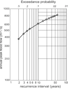
Peak flows on 14 August (747 m3s−1) and on 29 September (750 m3s−1) were consid-ered 30-year recurrence events based on the 1954–2005 flood-history record (Figs. 5 10
and 6). The annual flood peak is 370 to 450 m3s−1, and the 10-year event is 620 m3s−1 (Fig. 6). The largest flood in recent history occurred in 1952, with an estimated flow in excess of 830 m3s−1. Prior to 1950, little is known of the flood history of the Ping River. A large flood in 1831 is believed to have caused major channel changes and sedimen-tation over the 13th Century city of Wiang Kum Kam, 6 km upstream from the Ban Ko 15
village study area (Velechovsky et al., 1987; Wood et al., 2004). Kidson et al. (2005) identified paleoflood evidence in the adjacent Mae Chaem River drainage with a peak discharge of 2479 m3s−1 which greatly exceeds the 1961 flood of 980 m3
s−1 , the
largest flood of the Mae Chaem record. Their paleoflood work suggests the potential for much larger flood peaks on the Ping River than those which occurred in the record 20
since 1950.
4 Measurements
We measured the thickness of mud sediment deposited on the floodplain at Ban Ko where the peak flooding was photographed at 16:00 on 29 September from the window
HESSD
4, 3839–3868, 2007
Floodplain sediment, 30-year flood, Ping
River, Thailand S. H. Wood and A. D. Ziegler Title Page Abstract Introduction Conclusions References Tables Figures ◭ ◮ ◭ ◮ Back Close
Full Screen / Esc
Printer-friendly Version Interactive Discussion
of a commercial aircraft (Fig. 7).
Sediment-thickness measurements were made on 2 October, and also on 7 Octo-ber to cover those areas that were underwater on 2 OctoOcto-ber. Our method was to slog through the wet mud-mantled fruit orchards and rice fields and measure soft mud thick-ness with a millimeter ruler at more than 200 locations over a 0.27-km2area (Fig. 8a). 5
Locations were determined with hand-held GPS units to a ±7 m precision. Where thick-ness was questionable, the light-brown mud was scraped away to the darker, firmer, gray mud of the August depositional surface Sediment thickness was also measured on floors of four elevated bamboo shade huts, where farmers rest in the heat of the day (Fig. 8b). Sediment from the upper part of the water column had settled on these 10
elevated platforms; and therefore, provided information to compare with the sediment thickness on the surrounding ground that received sedimentation from the full water column. In March 2006 an elevation profile was surveyed using a laser level in order to better understand the pattern of flooding (Fig. 9).
5 Results
15
5.1 Sediment concentration
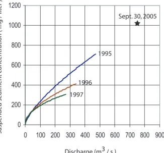
Total suspended sediment concentration of 1020 mg L−1was determined from one grab sample of the turbulent, muddy, brown floodwaters at Chiang Mai. Sample was taken from 0.2-m deep at the west abutment of Nawarat Bridge near the P-1 gaging station at 16:00 on 30 September. River was in full flood at 740 m3s−1(4.9 m stage). This value is 20
much higher than any values shown on sediment rating curves (1994–1997) (Fig. 10). Because our 1020 mg L−1concentration was taken just after peak flow, it might be low
compared with the concentrations on the rising limb of the flood hydrograph. We have only this limited sediment concentration data for the Ping River; however, in monitor-ing a 75-km2 tributary watershed, values sometimes exceed 8000 mg L−1during large
25
runoff events (Ziegler, unpublished data). Thus, there is potential for relatively high 3845
HESSD
4, 3839–3868, 2007
Floodplain sediment, 30-year flood, Ping
River, Thailand S. H. Wood and A. D. Ziegler Title Page Abstract Introduction Conclusions References Tables Figures ◭ ◮ ◭ ◮ Back Close
Full Screen / Esc
Printer-friendly Version Interactive Discussion
concentrations in the Ping. Despite only having one sample, and knowing little about the sediment-concentration hysteresis pattern of typical large flows in the Ping river, we estimate that the floodwater contained between 800 to 1500 mg L−1 of suspended solids when it inundated the study site at Ban Ko.
5.2 Sediment thickness 5
Greatest thickness in the Ban Ko study area was 15 cm of silty-fine-sand sediment along the levee on the north side of the Ping River (Site A, Fig. 11). A pocket of thick sediment was located near the tributary channel. Sediment thicker than 8 cm covered 16% of the study area, and extended no more than 250 m from the main channel. Sediment thicker than 4 cm covered 44% of the area and extended no more than 350 m 10
from the main channel. At a distance of 450 m from main channel, sediment thickness diminished to 0.5 cm (Fig. 11). Thickness averaged over the 0.27-km2 area is 3.3 cm; this equates to a wet sediment volume of roughly 9000 m3. Converting the volume of wet sediment (ρwet=1.6 g cm−3, water content = 0.60) to dry weight indicates that
about 9000 Mg of material was deposited over the 0.27-km2 area. The average dry 15
sediment deposit is 33 kg m−2; however, 72% of this material is bounded by the 2-cm isopach contour, within 200–400 m of the river channel.
Sediment thicknesses were measured on elevated platforms of 4 huts (Fig. 12). These data indicate that the amount of sediment intercepted by the platform, and that which settled to the bottom was roughly proportional to the thickness of the overlying 20
water column. For example, at hut H2 (Fig. 8b) the flood depth was 1.2 m over the ground and 0.55 m over the hut floor (Fig. 12). From these observations we conclude that the suspended sediment concentrations were relatively uniform in the water col-umn from which sediment settled. In other words, the water delivered to the point of sedimentation was well mixed from top to bottom.
HESSD
4, 3839–3868, 2007
Floodplain sediment, 30-year flood, Ping
River, Thailand S. H. Wood and A. D. Ziegler Title Page Abstract Introduction Conclusions References Tables Figures ◭ ◮ ◭ ◮ Back Close
Full Screen / Esc
Printer-friendly Version Interactive Discussion
5.3 Appearance of sediment layers
Fine sand occurred only on the levee area, within 50 m of the main channel of the Ping River (Fig. 13a). Within 150 m of the main channel is a 3-to-6-cm layer of coarse silt (0.03–0.06 mm) showing indistinct upward fining (Fig. 13b). This coarse silt was overlain by a distinct layer of massive clayey silt in some locations (Fig. 13c). We 5
believe this two-layer stratigraphy occurred in low areas that were fed floodwater at a lesser velocity than the initial surge that bore the coarse silt. At more distant sites the sediment was entirely massive clayey silt (Fig. 13c).
When photographed on 4 November, beneath the light-brown sediment of the September flood was gray clayey silt (Figs. 13b, c, d), which at sites P2 and B is 9-cm 10
thick over a thin leaf layer that was assumed to be the pre-August flood surface. This sediment changed to a gray color within only 2.5 months. The August sediment was submerged by water for at least 1.5 months, whereas the water from the September flood drained within 2–3 weeks. The gray layer shown in Fig. 13c contained mm-scale light-brown streaks of coarser silt. Bioturbation of the flood sediment had already begun 15
at some sites, as was indicated by rust-colored outlines of insect burrows, abundant in the gray sediment layer shown in Fig. 13b. In areas where sediment was less than 1.5 cm thick, the September sediment could not be discerned as a separate layer.
5.4 Density and grain-size analysis
Wet density of the mud and grain-sizes were determined for seven samples in the study 20
area (Fig. 14). Density of most wet mud samples varied from 1.6 to 1.7 g cm−3; and the water content (water mass/mass of dry solids) ranged from 0.67 to 0.83. Grain size analyses indicate these sediments to be a silt with 20 to 45 per cent clay (Fig. 14). One sediment sample located at point A (Fig. 11) had a density and moisture content of 1.86 g cm−3 and 0.3, respectively. This was a silty fine sand with 45 per cent fine 25
sand and 17 per cent clay that was deposited on the levee about 15 m from the chan-nel. Collectively the analyses show that grain size diminishes with distance from the
HESSD
4, 3839–3868, 2007
Floodplain sediment, 30-year flood, Ping
River, Thailand S. H. Wood and A. D. Ziegler Title Page Abstract Introduction Conclusions References Tables Figures ◭ ◮ ◭ ◮ Back Close
Full Screen / Esc
Printer-friendly Version Interactive Discussion
tributary channel. This pattern in grain size, and particularly the pattern in thickness, suggests that the tributary channel was a primary conveyor of sediment from the Ping River to the floodplain.
6 Discussion
6.1 Nature and extent of flooding 5
The flooded Ban Ko study area is shown in the 29 September photograph (Fig. 7). Water delivered to this area flowed over the levee on the main channel of the Ping River, as well as up a low-gradient tributary channel – and then most likely set up a weak current over the floodplain area that exited over the levees (Fig. 11). The estimated flooded area shown in the photograph is about 1 km2 (Fig. 10). Based on 10
water level stains (Fig. 8a) and the level survey (Fig. 9), the average depth of floodwater in the back-levee area was 1.2 m which is equivalent to a water volume of 1.2 million cubic meters. Because the bed of the tributary channel grades to the low-water main-channel bed, the tributary main-channel at flood stage could accommodate flow through a cross section 5 m deep and 12 m wide. This particular tributary channel did not have 15
a flood gate, as many channel/canals in the area do. Floodwater overtopping roads did not damage the levees; and no substantial breaches occurred, despite floodwater reaching 0.5 m at some places.
It is useful to consider how the sediment could have been conveyed to the floodplain through the channel of the tributary. Discharge of water flowing at 1.5 m s−1 velocity 20
through the tributary channel (5-m deep and 12-m wide) would have been 90 m3s−1. The depth of water over much of the 0.27 km2area was 1.0 to 1.4 m deep, which con-verts to a volume of 1.2 million cubic meters. About 4 h would be needed to deliver 1.2 million cubic meters. If the sediment were delivered by one ingress of water to flood the area to a depth of 1.2 m, we can estimate the thickness that would have been 25
bear-HESSD
4, 3839–3868, 2007
Floodplain sediment, 30-year flood, Ping
River, Thailand S. H. Wood and A. D. Ziegler Title Page Abstract Introduction Conclusions References Tables Figures ◭ ◮ ◭ ◮ Back Close
Full Screen / Esc
Printer-friendly Version Interactive Discussion
ing 1000 mg L−1 of sediment. That sediment, if settled, would have a mass of 0.12 g. Sediment with an average density of 1.6 g cm−3, would amount to only 0.75 mm thick-ness. Because we measured an average of 3.3 cm thickness over the area (Fig. 11), it is clear that the deposited sediment resulted from at least 40 volumes of flood water (3.3 cm÷0.075 cm=44). The data from the elevated platforms of huts suggest that each 5
water columns from which the sediment was derived was well mixed, and not greatly stratified. Therefore, a flow of water into this area must have occurred on the time scale of 1–2 days, not several hours, to produce the observed sediment thicknesses – and this supports the role of backflow up the small tributary stream as conveying some of the flood water from the Ping River. The greater sedimentation near the tributary 10
channel is similar to that of a crevasse splay, but differs because the channel deliver-ing floodwater to the floodplain was not a breach in the levee, but rather a preexistdeliver-ing tributary channel that graded to the low-water bed of the main channel, and delivered mostly silt rather than sand typical of crevasse splay deposits. While the pattern we found at the Ban Ko study area cannot be applied to the whole Ping River floodplain, 15
it can serve as an indicator for areas that were submerged more than 1 m for similar lengths of time. Figure 7 shows that the southeast side of the river was not significantly flooded, because the levees were higher and there were no major openings in the levee. In addition, sandbags placed along the road held back much of the floodwater. The flooded river was not surveyed from the air over its length at peak flood, so we 20
cannot estimate amount of sediment deposited over the entire Chiang Mai basin. We did observe a similar 1-to-8-cm of sedimentation within the low areas of the Chiang Mai city, and therefore believe these results are a useful indicator of sedimentation in the extensively flooded areas there as well.
6.2 Comparison with other flood studies 25
Floodplain sedimentation is patchy and irregular; and it occurs mostly where channels and unleveed low areas route floodwaters to otherwise leveed areas, and to low
HESSD
4, 3839–3868, 2007
Floodplain sediment, 30-year flood, Ping
River, Thailand S. H. Wood and A. D. Ziegler Title Page Abstract Introduction Conclusions References Tables Figures ◭ ◮ ◭ ◮ Back Close
Full Screen / Esc
Printer-friendly Version Interactive Discussion
eas of the floodplain. Our data generally show the exponential decline in sediment thickness away from the main channel (Fig. 11a) that is reported in other studies of flood sediment, and long-term vertical accretion (Bridge, 2003). The overall scale of floodplain sedimentation is less than, but similar to, that of the April–June, 1973 flood on the Mississippi in Louisiana (USA). For that flood, Kesel et al. (1974) found that 5
sediment thickness and texture decreases away from the river: e.g., 400 m from the river, sediment thickness was about 2 cm; however sediment depths of 0.5 to 1.0 cm extended 10 km away from the channel. Peak discharge of the 1973 Mississippi flood was 42 500 m3s−1, and large areas were inundated with 4 m of water for 2 months. Suspended sediment concentrations were not reported.
10
Gomez et al. (1995) found remarkably small sediment thickness (<0.4 cm) on leveed and unleveed floodplain areas from the July–August 1993 flood, which had a peak dis-charge of 12 320 m3s−1on the upper Mississippi River. At Keokuk, Iowa this discharge was about 20% larger than that of the 1973 flood mentioned above. They attribute low sedimentation to relatively low suspended sediment concentrations (<500 mg L−1). 15
However, extensive mud-draped sand deposits up to 30 cm thick are documented out to 6.4 km (4 miles) from the channel, at the levee break at Miller City, Illinois (Jacobson and Oberg, 1997)
Similarly, the September 1999 flood associated with Hurricane Floyd, on the Tar River, North Carolina (5654 km2drainage area), deposited only a thin layer of sediment 20
on the floodplain (Leece et al., 2004). This flood had a peak discharge of 1999 m3s−1 and a duration of almost 30 days. It was considered the >500-year-recurrence flood; and water depth in some floodplain areas was 3 m. Median thickness of fine sediment was 0.09 cm, and the maximum was 1 cm over the 2–5 km wide floodplain. They esti-mated maximum suspended sediment concentrations were less than 465 mg L−1; and 25
the authors attribute small deposition to low suspended sediment concentrations. The 2005 flood deposits we found at Ban Ko site along the Ping River are thicker than those described in the literature because of greater suspended sediment concen-trations, and also because conveyance of the floodwater was not simply overbank flow.
HESSD
4, 3839–3868, 2007
Floodplain sediment, 30-year flood, Ping
River, Thailand S. H. Wood and A. D. Ziegler Title Page Abstract Introduction Conclusions References Tables Figures ◭ ◮ ◭ ◮ Back Close
Full Screen / Esc
Printer-friendly Version Interactive Discussion
Much of the floodwater conveyance to the floodplain at Ban Ko was through a tributary channel; and this allowed thick sediment deposits to occur farther inland than would be expected for only overbank flooding.
7 Conclusions
Two of the three 2005 floods on the Ping River reached peak flows near the estimated 5
30-year recurrence interval. Duration of these floods was 2 days (14–15 August) and then 3 days (29 September–1 October). Low floodplain areas of the city of Chiang Mai and elsewhere in the Chiang Mai Basin were flooded with water up to 1.5 m deep, extending out to 1 km from the main channel. The significance of the sediment dis-tribution patterns we observed at the Ban Ko flood site is that long-term stratigraphic 10
evidence from floods of this magnitude is only likely to be preserved in deposits within about 100 m of the river channel – either on the levee, in areas where the levee was breached, or locations where tributary channels allow ingress of floodwaters to the floodplain. These deposits are fine sand and clayey coarse silt, have thicknesses of 5–10 cm, and may survive bioturbation by soil fauna and emerging roots. More distal 15
areas with less than 3-cm-thick deposits of clayey silt would probably not survive as dis-crete layers in the stratigraphy of the floodplain deposits. We observed that such thin deposits were already burrowed by insects 3 months after deposition. Sedimentation by the relatively short-duration floods we studied was greater than that reported from many North American and European examples, largely because the suspended sedi-20
ment concentration was greater (estimated to be in the range 800–1500 mg L−1 versus
<500 mg L−1 for the Northern American and European examples). Furthermore, the
conveyance of floodwater was not simply overbank flow, but was augmented by inflow of floodwaters through a tributary channel that did not have a flood gate.
Acknowledgements. The authors would like to thank T. Sukhapunnaphan and his staff at the
25
Royal Irrigation Department in Chiang Mai for providing Ping River flow data for this study. We thank T. Bundarnsin and T. Chantaphan for help in the field and lab; and S. Singharajwarapan
HESSD
4, 3839–3868, 2007
Floodplain sediment, 30-year flood, Ping
River, Thailand S. H. Wood and A. D. Ziegler Title Page Abstract Introduction Conclusions References Tables Figures ◭ ◮ ◭ ◮ Back Close
Full Screen / Esc
Printer-friendly Version Interactive Discussion and F. Singharjwarapan for always helpful discussions and use of lab and office space at the
Department of Geological Sciences at Chiang Mai University. We also thank the residents of Ban Ko village for information and hospitality. The study would not have been done properly were it not for the superb view of the flood provided by the pilot of Thai Airlines Flight 923 on 29 September. This work was partially supported by grants from the Asia Pacific Network
5
(ARCP2006-06NMY; ARCP200701CMY) and NASA (IDS/03-0365-0079).
References
Asian Disaster Preparedness Center: Rapid assessment: Flashflood and landslide disaster in the provinces of Uttaradit and Sukhothai, Northern Thailand, May 2006, available atwww.
adpc.net/enewsjuly/Uttaradit rapidassessment.pdf, 2006.
10
Asselman, N. E. M. and Middlekoop, H.: Floodplain sedimentation: Quantities, patterns and processes, Earth Surf. Processes Landforms, 20, 481–499, 1995.
BBC News: Thailand flood kills 70, available at http://news.bbc.co.uk/1/hi/world/asia-pacific/
1487394.stm, 2001.
Bridge, J. S.: Rivers and Floodplains, Blackwell Science, Oxford. 492 p., 2003.
15
Charuppat, T.: Forest situation in Thailand in the past 37 years (1961–1998), Forest Research Office (Bangkok), Royal Forest Department, 1998 (in Thai).
Gomez, B., Mertes, L. A. K., Phillips, J. D., Magilligan, F. J., and James, L. A.: Sediment characteristics of an extreme flood: 1993 upper Mississippi River valley, Geology, 23(11), 963–966, 1995.
20
Jacobson, R. B. and Oberg, K. A.: Geomorphic changes on the Mississippi River flood plain at Miller City, Illinois, as a result of the flood of 1993, U.S. Geological Survey Circular 1120-J, 22 p., 1997.
Kesel, R. H., Dunne, K. C., McDonald, R. C., Allison, K. R., and Spicer, B. E.: Lateral erosion and overbank deposition on the Mississippi River in Louisiana caused by 1973 flooding,
25
Geology, 2, 461–464, 1974.
Kidson, R., Richards, K. S., and Carling, P. A.: Reconstructing the ca. 100-year flood in North-ern Thailand, Geomorphology, 70, 279–295, 2005.
Leopold, L. B. and Wolman, M. G.: River channel patterns: braided, meandering, and straight, U.S. Geological Survey Professional Paper, 282-B, 39–85, 1957.
HESSD
4, 3839–3868, 2007
Floodplain sediment, 30-year flood, Ping
River, Thailand S. H. Wood and A. D. Ziegler Title Page Abstract Introduction Conclusions References Tables Figures ◭ ◮ ◭ ◮ Back Close
Full Screen / Esc
Printer-friendly Version Interactive Discussion Leece, S. A., Pease, P. P., Gares, P. A., and Rigby, C. A.: Floodplain sedimentation during an
extreme flood: The 1999 Flood on the Tar River, eastern North Carolina, Phys. Geography, 24(4), 334–346, 2004.
Margane, A. and Tatong, T.: Aspects of the hydrogeology of the Chiang Mai-Lamphun basin, Thailand that are important for the groundwater management, Zeitschrift fuer Angevandte
5
Geologie, 45, 188–197, 1999.
Rhodes, B. P., Conejo, R., Benchawan, T., Titus, S., and Lawson, R.: Paleocurrents and Prove-nance of the Mae Rim Formation, Northern Thailand: Implications for Tectonic Evolution of the Chiang Mai Basin, The Journal of the Geological Society of London, 162, 51–63, 2005. Royal Irrigation Department (Thailand): Hydrologic Yearbook, v. 41, Royal Irrigation
Depart-10
ment, Hydrology Division, Bangkok, 1995.
Royal Irrigation Department (Thailand): Hydrologic Yearbook, v. 41, Royal Irrigation Depart-ment, Hydrology Division, Bangkok, 1996.
Royal Irrigation Department (Thailand): Hydrologic Yearbook, v. 41, Royal Irrigation Depart-ment, Hydrology Division, Bangkok, 1997.
15
Thomas, D., Weyerhaeuser, H., and Saipathong, P.: Improved tools for managing agroforestry landscapes in northern Thailand: Pilot application of spatial analysis and negotiation support systems, in: Landscapes of Diversity: Indigenous Knowledge, Sustainable Livelihoods and Resource Governance in Montane Mainland Southeast Asia, edited by: Jianchu, X. and Mikesell, S., Proceedings of the III Symposium on MMSEA, 25–28 August 2002, Lijiang,
20
P.R. China, Kunming: Yunnan Science and Technology Press, 2002.
Velechovsky, M., Sinthusan, A., and Pitragool, S.: Geological aspects of the burial by flood of the ancient city of Wiang Kum Kam, Chiang Mai, Thailand, Chiang Mai University, Center for the Promotion of Arts and Culture, unpublished report, 18 pp., 1987.
Wood, S. H., Liberty, L. M., Singharajwarapan, F. S., Bundarnsin, T., and Rothwell, E.:
Fea-25
sibility of gradient magnetometer surveys of buried brick structures at 13th Century (C.E.) Wiang Kum Kam, Chiang Mai Province, Thailand, in: Proceedings of the International Con-ference on Applied Geophysics, Chiang Mai, edited by: Rieb, S., Wongpornchai, P., and Chantraprasert, S., Department of Geological Sciences, Chiang Mai University, p. 22–30, available athttp://earth.boisestate.edu/home/swood, 2004.
30
Wood, S. H., Ziegler, A. D., and Bundarnsin, T.: Floodplain deposits, channel changes, and riverbank stratigraphy of the Mekong River area at the 14th Century city of Chiang Saen, Northern Thailand, Geomorphology, in press, 2007.
HESSD
4, 3839–3868, 2007
Floodplain sediment, 30-year flood, Ping
River, Thailand S. H. Wood and A. D. Ziegler Title Page Abstract Introduction Conclusions References Tables Figures ◭ ◮ ◭ ◮ Back Close
Full Screen / Esc
Printer-friendly Version Interactive Discussion Ziegler, A. D., Giambelluca, T. W., Sutherland, R. A., Nullet, M. A., Yarnasarn, S., Pinthong, J.,
Preechapanya, P., and Jaiarree, S.: Toward understanding the cumulative impacts of roads in agricultural watersheds of montane mainland Southeast Asia, Agriculture, Ecosystems, and Environment, 104, 145–158, 2004.
HESSD
4, 3839–3868, 2007
Floodplain sediment, 30-year flood, Ping
River, Thailand S. H. Wood and A. D. Ziegler Title Page Abstract Introduction Conclusions References Tables Figures ◭ ◮ ◭ ◮ Back Close
Full Screen / Esc
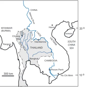
Printer-friendly Version Interactive Discussion Hanoi Phnom Penh Ho Chi Minh Vientienne Bangkok Rangoon 300 km 20 o 10 o VI ET N AM CAMBODIA THAILAND MYANMAR (BURMA) CHINA LAO S Me ko ng R ive r Chiang Mai Pi ng R ive r HAINAN SOUTH CHINA SEA
Fig. 1. Location of the Ping River. Dark shaded area is drainage area upstream of Chiang Mai and the study area.
HESSD
4, 3839–3868, 2007
Floodplain sediment, 30-year flood, Ping
River, Thailand S. H. Wood and A. D. Ziegler Title Page Abstract Introduction Conclusions References Tables Figures ◭ ◮ ◭ ◮ Back Close
Full Screen / Esc
Printer-friendly Version Interactive Discussion Fig. 2. Outline of the Ping River drainage (dotted line) upstream of the study area showing
the location of the dam on the Nam Mae Ngad which regulates flow from 1/5 of the drainage. Labeled cities are those provincial capitols which reported major flooding 12 August–4 October 2005.
HESSD
4, 3839–3868, 2007
Floodplain sediment, 30-year flood, Ping
River, Thailand S. H. Wood and A. D. Ziegler Title Page Abstract Introduction Conclusions References Tables Figures ◭ ◮ ◭ ◮ Back Close
Full Screen / Esc
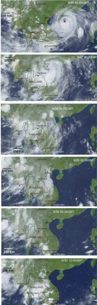
Printer-friendly Version Interactive Discussion Fig. 3. Satellite images
show-ing the westward travelshow-ing tropi-cal storm from Typhoon Damrey,
25–30 September 2005. Ping
River drainage basin above Chi-ang Mai P1 gage outlined with dotted line. From archive of EEI-lab, Kochi University, MTSAT IR IR1 JMA. Thailand local time is 7 h later than GMT.
HESSD
4, 3839–3868, 2007
Floodplain sediment, 30-year flood, Ping
River, Thailand S. H. Wood and A. D. Ziegler Title Page Abstract Introduction Conclusions References Tables Figures ◭ ◮ ◭ ◮ Back Close
Full Screen / Esc
Printer-friendly Version Interactive Discussion
Chiang Dao Precip - Sept, 2005
0.0 50.0 100.0 150.0 200.0 250.0 1 3 5 7 9 11 13 15 17 19 21 23 25 27 29 day p r e c i p ( m m )
Fig. 4. September 2005 daily precipitation at the Ban Pahng Ma Oh Watershed Research Station, Mae Na Subdistrict, Chiang Dao District. No rain occurred for several weeks after the 30 September storm.
HESSD
4, 3839–3868, 2007
Floodplain sediment, 30-year flood, Ping
River, Thailand S. H. Wood and A. D. Ziegler Title Page Abstract Introduction Conclusions References Tables Figures ◭ ◮ ◭ ◮ Back Close
Full Screen / Esc
Printer-friendly Version Interactive Discussion
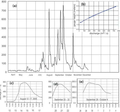
April May June July August September October November December
0 100 200 300 400 500 600 700 800 discharge (m3 / s) b 0.0 1.0 2.0 3.0 4.0 5.0 6.0 gauge hei ght (m eters ) discharge (m3 / s) 0 100 200 300 400 500 600 700 800 800 600 400 200 0 12 13 14 15 16 August 12 -17, 2005 17 12:00 0:00 12:00 0:00 12:00 0:00 12:00 0:00 12:00 0:00 12:00 0:00 0:00 di sch arg e (m 3 / s) 0:00 12:00 0:00 12:00 0:00 12:00 0:00 20 21 22 September 20 - 22 800 200 400 600 0 0.0 200.0 400.0 600.0 800.0 September 28 - October 4 12:00 0:00 12:00 0:00 12:00 0:00 12:00 0:00 0:00 12:00 0:00 0:00 12:00 12:00 0:00 28 29 30 1 2 3 4 (a) (b) (c) (d) (e)
Fig. 5. Hydrographs of daily-mean flow readings at the P1 gage at Narawat Bridge in Chiang Mai. (a) the mean-daily flow 2005 hydrograph, (b) Stage-flow relationship, (c) hourly flow – 12– 13 August, (d) hourly flow – 20–22 September, and (e) hourly flow – 29 September–2 October, (Data from Royal Irrigation Department, Hydrology and Water Management Office: internet site:http://www.hydro-1.net).
HESSD
4, 3839–3868, 2007
Floodplain sediment, 30-year flood, Ping
River, Thailand S. H. Wood and A. D. Ziegler Title Page Abstract Introduction Conclusions References Tables Figures ◭ ◮ ◭ ◮ Back Close
Full Screen / Esc
Printer-friendly Version Interactive Discussion Fig. 6. Flood frequency graph constructed from the 1954 to 2005 record, and including the
reported record peak flood flow of 830 m3/s of 1952. Graph from an unpublished report of the Hydrology and Water Management Center for the Upper Northern Region of the Royal Irrigation Department.
HESSD
4, 3839–3868, 2007
Floodplain sediment, 30-year flood, Ping
River, Thailand S. H. Wood and A. D. Ziegler Title Page Abstract Introduction Conclusions References Tables Figures ◭ ◮ ◭ ◮ Back Close
Full Screen / Esc
Printer-friendly Version Interactive Discussion Fig. 7. Photo from airplane of the flooded area of the Ping River at peak flood flow 16:00,
29 September 2005. View is to the east toward the bridge at Ban Mae Kha. Tributary channel joins the river on the right (downriver) side of photo. Area of mapped sediment thickness (Fig. 5) extends from the white building (left center of photo) to the river.
HESSD
4, 3839–3868, 2007
Floodplain sediment, 30-year flood, Ping
River, Thailand S. H. Wood and A. D. Ziegler Title Page Abstract Introduction Conclusions References Tables Figures ◭ ◮ ◭ ◮ Back Close
Full Screen / Esc
Printer-friendly Version Interactive Discussion Fig. 8. (a) high water line on fruit trees. Floodwater depth was 1.3 m. Location is at point B of
Fig. 11. View is to the southeast. (b) hut located at point H2 on Fig. 11. Five cm of sediment deposited on platform elevated 0.55 m above ground (see Fig. 12). Photos taken on 2 October.
HESSD
4, 3839–3868, 2007
Floodplain sediment, 30-year flood, Ping
River, Thailand S. H. Wood and A. D. Ziegler Title Page Abstract Introduction Conclusions References Tables Figures ◭ ◮ ◭ ◮ Back Close
Full Screen / Esc
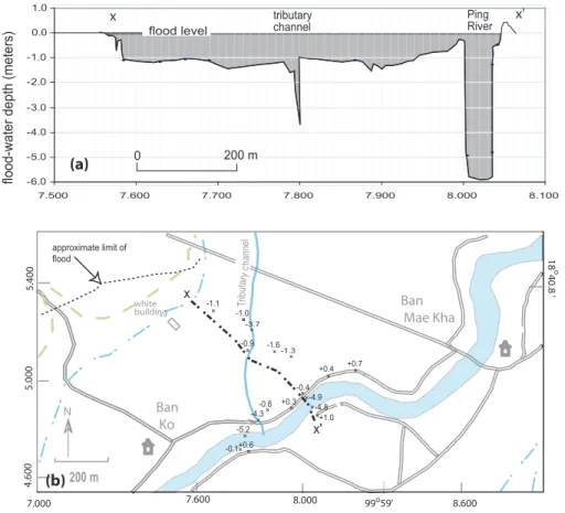
Printer-friendly Version Interactive Discussion -6.0 -5.0 -4.0 -3.0 -2.0 -1.0 0.0 1.0 0 200 m flood level flood-w ater depth (m eters ) 7.500 7.600 7.700 7.800 7.900 8.000 8.100 x x' Ban Mae Kha Ban Ko 99o59' 7.000 7.600 8.000 4.600 5.000 5.400 8.600 18 o 40.8 ' white building 200 m N T ri buta ry c ha nn el + + + + + + + + ++ + + + -3.7 -1.3 -1.0 -0.6 -1.6 +0.7 +0.4 -0.4 -4.9 -4.3 + -5.2 + -0.1+0.6+ +-4.8 ++1.0 -1.1 -0.9 + +0.3 x x' approximate limit of flood tributary channel Ping River (a) (b)
Fig. 9. (a) Map of surveyed ground elevations below maximum flood level. (b) elevation profile along line x-x′showing maximum flood level in area of sediment thickness survey.
HESSD
4, 3839–3868, 2007
Floodplain sediment, 30-year flood, Ping
River, Thailand S. H. Wood and A. D. Ziegler Title Page Abstract Introduction Conclusions References Tables Figures ◭ ◮ ◭ ◮ Back Close
Full Screen / Esc
Printer-friendly Version Interactive Discussion 0 200 400 600 800 1000 1200 0 100 200 300 400 500 600 700 800 900 Discharge (m3 / s ) susp ended sedimen t c onc en tr a tion ( mg / lit er ) 1995 1996 1997 Sept. 30, 2005
Fig. 10. Suspended sediment concentration (single surface grab sample) measured during flood flow of 750 m3/s on 30 September 2005 at Narawat Bridge, compared to suspended-sediment rating curves for the Ping River P1 based on sampling by the Royal Irrigation Depart-ment in 1994, 1995, 1996, and 1997. In those years peak flows reached 525, 467, 342, and 270 m3/s, respectively.
HESSD
4, 3839–3868, 2007
Floodplain sediment, 30-year flood, Ping
River, Thailand S. H. Wood and A. D. Ziegler Title Page Abstract Introduction Conclusions References Tables Figures ◭ ◮ ◭ ◮ Back Close
Full Screen / Esc
Printer-friendly Version Interactive Discussion Ban Mae Kha Ban Ko 99o59' 7.000 7.600 8.000 4.600 5.000 5.400 8.600 18 o 40.8 ' white building 200 m N Trib ut ary cha nn el 8 0.5 cm 1 cm 10 cm 4 8 15 cm 2 cm 2 cm 1 cm 0.5 cm 2 cm cm 4 cm 4 cm 8 cm 6 cm H1 H2 H3 H2 P1 P2 A B C D E G F 8 0.5 cm 1 cm 10 cm 4 2 15 cm 10 2 cm 2 cm 1 cm 0.5 cm 2 cm cm 4 cm 4 cm 8 cm x' approximate limit of flood x (a) (b) s edi m ent thi c k nes s (c m ) 200 m 0 2 4 6 8 10 12 x x'
Fig. 11. (a) Profile of wet sediment thickness along line x-x′. (b) Isopach map of wet-sediment
thickness deposited on floodplain and levee during the 29 September–2 October flood. Points A–G are locations of samples for which grain size analysis are shown in Fig. 14. Points H1-H4 are locations where thicknesses were measured on elevated platforms as well as on the surrounding ground (data shown in Fig. 9). Line x-x′is the line of profiled thickness in Fig. 11a
and profiled elevation in Fig. 9b. Photos of sediment are shown in Fig. 13 at locations A, B, P1, and P2.
HESSD
4, 3839–3868, 2007
Floodplain sediment, 30-year flood, Ping
River, Thailand S. H. Wood and A. D. Ziegler Title Page Abstract Introduction Conclusions References Tables Figures ◭ ◮ ◭ ◮ Back Close
Full Screen / Esc
Printer-friendly Version Interactive Discussion 0.00 0.20 0.40 0.60 0.80 1.00 1.20 1.40 0 1 2 3 4 5 6 7 8 9 sedimen t thick ness (cm) w a ter c olumn thick ness (m) H1(B) H2 H3 H4
Fig. 12. Upper graph shows thickness of the column of water over elevated platforms (dark pattern) compared to the total depth of water at the site (pale pattern). Sediment thickness de-posited on elevated platforms (dark pattern) compared to thickness on the surrounding ground (pale pattern). Locations of H1(B), H2, H3, H4 shown in Fig. 11.
HESSD
4, 3839–3868, 2007
Floodplain sediment, 30-year flood, Ping
River, Thailand S. H. Wood and A. D. Ziegler Title Page Abstract Introduction Conclusions References Tables Figures ◭ ◮ ◭ ◮ Back Close
Full Screen / Esc
Printer-friendly Version Interactive Discussion Fig. 13. Photographs of 29 September–2 October sediment at locations P1, P2, B, and A
shown in Fig. 5. (a) Brown, massive, clayey coarse silt overlying grey clay of the August flood at point, P1, 100 m from river channel. The 6-cm-thick layer shows slight upward fining, and has developed several rust-stained insect burrows when photographed 2 months after depo-sition. 4 November photo. (b) Sediment shows a basal 3.5-cm layer of brown clayey coarse silt overlain by 3.5 cm of pale brown clayey silt that has dried and parted from the layer below. The underlying gray August sediment has light-brown silty streaks. 4 November photo at point P2, 160 m from river channel. (c) Massive 5-cm layer of brown clayey silt at site B, 200 m from the river channel. Grain-size analysis shown in Fig. 10. 4 November photo. (d) River-channel-facing levee deposit on a 20-degree slope at site A. Deposit is 15 cm of brown silty fine sand (grain-size analysis shown in Fig. 10). 7 October photo.
HESSD
4, 3839–3868, 2007
Floodplain sediment, 30-year flood, Ping
River, Thailand S. H. Wood and A. D. Ziegler Title Page Abstract Introduction Conclusions References Tables Figures ◭ ◮ ◭ ◮ Back Close
Full Screen / Esc
Printer-friendly Version Interactive Discussion sand A B C D E F G 1 0.1 0.01 0.001 0.0001 20 40 60 80 100 0 Pe rce n t fi n e r th a n D D, grain diameter (mm)
sand silt clay
Fig. 14. Sediment grain size analysis for sample locations shown by points A, B, C, D, G, and F in Fig. 11. Analysis by standard hydrometer and wet-sieving methods.