HAL Id: hal-00371783
https://hal.archives-ouvertes.fr/hal-00371783
Submitted on 26 May 2021
HAL is a multi-disciplinary open access
archive for the deposit and dissemination of
sci-entific research documents, whether they are
pub-lished or not. The documents may come from
teaching and research institutions in France or
abroad, or from public or private research centers.
L’archive ouverte pluridisciplinaire HAL, est
destinée au dépôt et à la diffusion de documents
scientifiques de niveau recherche, publiés ou non,
émanant des établissements d’enseignement et de
recherche français ou étrangers, des laboratoires
publics ou privés.
First Satellite Image of a Moving Pyroclastic Flow
Soo Chin Liew, Jean-Claude Thouret, Anupam Gupta, Leong Keong Kwoh
To cite this version:
Soo Chin Liew, Jean-Claude Thouret, Anupam Gupta, Leong Keong Kwoh. First Satellite Image of
a Moving Pyroclastic Flow. Eos, Transactions American Geophysical Union, American Geophysical
Union (AGU), 2008, 89, pp.22. �10.1029/2008EO220002�. �hal-00371783�
Eos, Vol. 89, No. 22, 27 May 2008
Pyroclastic flows that emerge from the bases of collapsing eruption columns or lava domes are transient dynamic phenom-ena, rarely documented due to their very brief existence, which may be only minutes. Such flows are commonly reconstructed from their deposits. They have been photo-graphed on the ground, but to the best of our knowledge, the pyroclastic flow described in this article is the first such flow in action that has been recorded on a satellite image. This provides an excellent opportunity to see the flow in action.
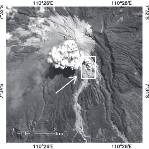
Mount Merapi, in Java, Indonesia, erupted several times in June 2006, and the 16 June IKONOS satellite imaging of the eruption coincided with the occurrence of a pyro-clastic flow, a block-and-ash flow related to dome growth and collapse on the volcano. Figure 1 shows the entire mountain and sur-rounding area, including the dome on the steep southwestern face of the volcano. Fig-ure 2, an enlargement of the outlined area in Figure 1, illustrates details of the pyro-clastic flow. A strong wind blew the ash
cloud away from the southern face of the volcano, improving the clarity of the image.
Figure 2 shows billowing clouds (mainly water vapor, gas, and ash) hugging the ground near the front and rising to a greater height farther back. The coarser material is confined to near the ground and the finer particles rise buoyantly toward the top, a process known as elutriation. This type of cloud is a coignimbrite ash cloud (also called a phoenix cloud), and fine material from it falls as a widespread deposit from the top of the hot pyroclastic flow.
In this picture, the ash cloud front is about 50 meters high and is marked by several bulges or billowing lobes that are separated by shearing from each other. The shears between the lobes are denser near the front, occurring along two directions, N80°E and N130°E, oblique to the valley. The pyroclastic flow, about 0.5 kilometers long and 0.25–0.5 kilometers wide, is moving down the head of the Gendol River valley on the southern slope of Merapi. The 1- meter resolution of the image displays the polylobate front of the flow and also the deposits left down-valley by earlier flows of this eruption. The pictured
pyroclas-tic flow, confined to the left side of the valley, crossed a ridge created by the flow deposit of 14 June. The earlier flow reached as far as 6 kilometers down- valley (Figure 1). The poor sorting of the material (a mixed range of par-ticle sizes), the scattered 1- to 4-meter boul-ders, and levees of pyroclastic deposits are all visible.
This satellite image, taken as IKONOS was above Merapi and when the flow had emerged from the volcano, provides a rare opportunity to study a pyroclastic flow in action.
Acknowledgments
The image that captured this event is taken from the archives of the Centre for Remote Imaging, Sensing and Processing (CRISP) at the National University of Singa-pore, where IKONOS images of Southeast Asia are stored. We acknowledge the role of Albert Ang Wu Chye of CRISP in processing the image.
—SOO CHIN LIEW, Centre for Remote Imaging, Sensing and Processing (CRISP), National University of Singapore, Singapore; JEAN-CLAUDE THOURET, Labo-ratoire Magmas et Volcans, Université Blaise- Pascal et Centre National de la Recherche Scientifique, Obser-vatoire de Physique du Globe de Clermont- Ferrand et Institut de Recherche pour le Développement, Clermont-Ferrand, France; AVIJIT GUPTA, Depart-ment of Geography, University of Leeds, Leeds, UK, and CRISP; E-mail: [email protected]; and LEONG
KEONG KWOH, CRISP
First Satellite Image of a Moving Pyroclastic Flow
PAGE 202
Fig. 1. Overview of Mount Merapi showing eruption clouds, the location of the pyroclastic flow of 16 June 2006 (Figure 2 is an enlargement of the outlined area), and previous pyroclastic and lahar deposits along the Gendol River valley. Note the locations of villages and rice fields to the southeast. Copyright CRISP. Reproduced with permission.
Fig. 2. Moving pyroclastic flow of 16 June 2006. Copyright CRISP. Reproduced with permission.