HAL Id: hal-00136174
https://hal.archives-ouvertes.fr/hal-00136174
Submitted on 13 Mar 2007
HAL is a multi-disciplinary open access
archive for the deposit and dissemination of
sci-entific research documents, whether they are
pub-lished or not. The documents may come from
teaching and research institutions in France or
abroad, or from public or private research centers.
L’archive ouverte pluridisciplinaire HAL, est
destinée au dépôt et à la diffusion de documents
scientifiques de niveau recherche, publiés ou non,
émanant des établissements d’enseignement et de
recherche français ou étrangers, des laboratoires
publics ou privés.
A generic methodology for partitioning unorganised 3D
point clouds for robotic vision
Nicolas Loménie
To cite this version:
Nicolas Loménie. A generic methodology for partitioning unorganised 3D point clouds for robotic
vision. May 2004, pp.64-72. �hal-00136174�
A generic methodology for partitioning unorganised
3D point clouds for robotic vision
Nicolas Lom´enie
Systems of Intelligent Perception lab (SIP - CRIP5), University Paris V, Paris, France
E-mail: [email protected]
Abstract :Range image segmentation has many applications in computer vision areas such as com-puter graphics and robotic vision. A generic method-ology for 3D point set analysis in which planar struc-tures play an important role is defined. It con-sists mainly of a specific K-means algorithm which is able to process different shapes in cluster. At the same time, within geometric and topologic consid-erations, a set of application-driven heuristics is de-signed. This helps to find out the right number of structures in point sets in order to give a good vi-sualization and representation of a large scale en-vironment without a priori models. Our aim is to propose a simple and generic frame for 3D scene un-derstanding. Tests were realised on different types of environment data: natural and man-made. This re-search project has been realized with EADS (French Air Space Society). Keywords: Fuzzy clustering, 3D reconstruction and scene analysis, range image segmentation, environment modeling, stereovision.
1
Introduction
Given a point set and an application, how should we process the point set in order to complete the ap-plication? The answer to this question is obviously of great interest in the field of computer vision and pattern recognition. Anyone who attempts to solve the problem refers himself to a spectific application and so to a specific kind of cloud of points. For in-stance, a now famous contest [3] consists in compar-ing the results of the segmentation of range images into planar regions. In this case, 3D point sets are structured on a regular 2D grid. Unfortunately, in stereoscopic vision problems of reconstruction, un-organised, inhomogeneous in density 3D point sets are obtained while laser range systems provide very dense 3D point sets [10]. For each of these applica-tions, authors have developped a specific algorithm to process point sets. In [6], the 4-connexity informa-tion is at the basis of the algorithms, making them unable to process unorganised point sets. In [1], the
diversity in shape, density and homogeneity of clus-ters to be formed is not involved in the algorithms, making them unable to process stereoscopic data. In [4], the range image is integrated with the reflectance map. Besides, the only systematic study of the per-formance of range image segmention algorithms [3] uses only planar patches.
In this paper, we will define a generic methodol-ogy in order to make partition in any 3D unorganised point set where planar structures are important. For this purpose, the next section describes a very robust clustering method introduced by [5]. But we propose to make it unsupervised in a more generic way. The fourth section focuses on the design of a set of heuris-tics and the third section brings these tools together in a generic methodology. Finally, section five illus-trates the efficiency of the proposed methodology on different data sets, from structured to unstructured environments.
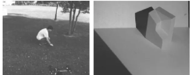
Figure 1: Different environments to be dealt with.
First of all, we propose to show the kind of en-vironments we want to analyse, just to insist on the diversity of their nature. Figure 11 shows a natu-ral environment which is captured by a stereoscopic system and a polyhedrical environment which is cap-tured by a laser range system. However, for making simpler, we focus on a specific robotic outdoor nav-igation goal. Natural images were acquired by the LAMA robot belonging to LAAS-French CNRS lab.
13D point set images are best viewed in color, as many
2
Clustering algorithm as
in-ference motor
Given a point set in ℜd, the problem consists in self-paritionning it without learning. In this perspective, K-means algorithms can do automatic classification, based on the minimisation of an objective function U , a fuzzy K-partition, and V a set of K prototypes:
J = N X j=1 K X i=1 (uij)md2(Xj, Vi); K ≤ N, (1)
where Xjis the coordinate vector of the jthpoint, Vi is the centroide of the ithcluster, uij is the mem-bership coefficient of Xj to Vi, d(Xj, Vi) is a distance between Xj and Vi, N is the number of points and K the number of clusters, and m(1 ≤ m) controls the fuzzy degree of the final partition. The fuzzy partition is performed by an iterative optimisation of equation 1.
This model is flexible enough to be able to deal with a great diversity of data, just by replacing the distance function or the expression of prototypes. For instance, when clusters of different shape and density are considered, we can introduce an “expo-nential” distance de, inspired by the estimation of the maximum of likelihood. This distance is involved in the computation of the a posteriori probability uij of selecting the ithcluster knowing the jthvector of coordinate Xj : uij = 1 d2 e(Xj,Vi) PK i=1 d2 1 e(Xj,Vi) , d2 e(Xj, Vi) = [det(Fi)]1/2 Pi exp[(Xj−Vi) TFi(Xj−Vi)/2], where Pi= 1 N N X j=1 uij and Fi= PN
j=1uij(Xj− Vi)(Xj− Vi)T PN
j=1uij
Fi being the fuzzy covariance matrix of the ith cluster and Pi the a priori probability of selecting the ithcluster.
This specific algorithm performs well in the cases of shape diversity (it is able to differentiate between linear and spherical clusters), density and size di-versity, which are characteristic properties of stereo-scopic data [8].
Besides, using a validity measure of partition called Average Partition Density ( AP D ), this algo-rithm gives an idea of the optimal number of clusters in the point set:
AP D(K) = 1 K K X j=1 Sj Vj
where the fuzzy hypervolume Vj and the ”sum of central moment” Sj are given by:
Vj= det(Fj)1/2and Sj= X xi∈Xj
uij
for each Xj= {x ∈ X : (x − vj)TP−1
j (x − vj) < 1}. Thus, we focus on this specific clustering method called UFP-ONC algorithm (unsupervised fuzzy par-tition - optimal number of classes) described in [5]. This generic algorithm is fundamental to our methodology in which it acts as inference motors do in knowledge-based systems.
Yet, unsupervised clustering is a somewhat arbi-trary concept in the field of data analysis. What is certain is that we rarely know what we are looking for. This is particularly the case in data mining ap-plications. In the computer vision field, things are somewhat easier. Most of the time, we know rather or less what kind of structures we are looking for, even without any available a priori model. In au-tonomous robotics for instance, the vision task con-sists in building an obstacle map. In this specific ap-plication, the nature of the structures we are looking for is binary: either navigable areas like the ground or obstacle areas emerging from the ground. In the range segmentation contest described in [3], the na-ture of clusters is represented by planar patches. Hence, some basic knowledge of the nature of ob-jects is sufficient to validate the clustering process. We propose to represent this basic knowledge by a set of heuristics. Henceforth an inference is a mean-ingful subset of points and the semantics is going to be captured by a set of topological, metric and geometrical heuristics.
3
Methodology
3.1
Axiom
Our methodology is based on an axiom.
Axiom 1 For any point set in which planar struc-tures play an important role, there is at least one K-partition derived by the U F P − ON C algorithm ex-hibiting a structuration into areas and objects which is adapted to any specific computer vision goal.
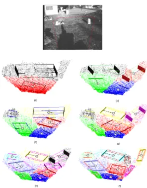
Let us illustrate this axiom in the context of au-tonomous robotic navigation goals. As a matter of fact, this observation has been verified on numerous such data scenes as outdoor natural environments. As a specific illustration, figure 2 shows that any K-partition for K between 2 and 10 provides a coher-ent interpretation of the scene. In association with each cluster, spheres represent the fuzzy center of gravity of the cluster and boxes represent the fuzzy eigen values and vectors of the correlation matrix of the point set corresponding to the cluster. The 2-partition exhibits a partitionning into foreground and background which differente each other by their point density. The 4-partition homogeneously di-vides the scene into four coherent areas, one of which, in the right background, gathers a white textured up-set dust bin and the rising part of the ground. The 5-partition isolates for the first time the stoney area in the left background. Finally, the 10-partition ex-hibits every obstacle identified in the scene and cor-rectly isolated from the navigable areas: the upset dust bin, the rising ground part and the stoney area. This series of K-partitions illustrates the “clever” behavior of the U F P − ON C algorithm in this kind of data. As a matter of fact, for any K-partition, one obtains a coherent and useful interpretation of the scene in K clusters.
However, the U F P − ON C algorithm doest not yet provide the optimal number of clusters to de-scribe the scene. The whole strategy of interpreta-tion is reliant on the determinainterpreta-tion of the optimal pa-rameter K. With this in mind, we briefly overviewed the partition measure of validity proposed in the lit-terature, focusing on the Average Density Partition or AP D(K) defined in [5] which appeared to be the most robust for our experiments.
Unfortunately, the use of this sole measure is un-able to guarantee an optimal interpretation of the scene for our robotic navigation purpose (the first local optimum of AP D(k) for k from one to ten is obtained for four clusters in the scene depicted in fig-ure 2). It may provide an under segmentation result. More details are generally required. To find out this optimal number K of clusters, we need to use some more heuristic criteria based on the geometry and topology of the segmented structures.
3.2
Strategy
Depending on the application, some specific charac-teristics of the clusters are required to belong to an optimal description of the point set. For instance, in a famous contest launched by Herbert [3] , several re-search teams can compare their range data
segmen-Figure 2: Typical scene for outdoor robotic naviga-tion. Red line delimitates the processed area and different K-partitions : (a) k=2 (b) k=4 (c) k=5 (d) k=6 (e) k=8 (f) k=10
tation into planar regions results using a database made of polyhedrical objets. In this case, the re-quired geometrical property for the clusters is pla-narity. In robotic stereoscopy, to avoid obstacles, we seek well-shaped and isolated clusters emerging from planar ground. Each application will need its own heuristics to perform the best partitionning ac-cording to some geometrical and topological require-ments. Thus, the proposed methodology is based on the U F P − ON C algorithm and the proposed axiom to build a generic range data partitionning process.
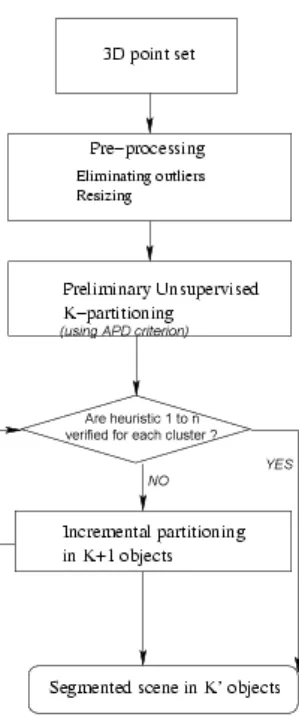
First, we process point sets to exhibit an ini-tial structuration by incrementally computing K-partition for K between 1 and 10, and we stop as soon as AP D(K) reaches a local maximum. From this first partitionning, in the case of clusters not verifying specific heuristics defined for the applica-tion, we continue the incremental partitionning pro-cess. This strategy is illustrated in the process chart of figure 3.
4
Heuristic set
The second fundamental element of the strategy con-sists in the creation of a set of heuristics to
caracter-Figure 3: Process chart of the basic strategy
ize the validity of a cluster. Just as the declara-tive knowledge concept used in expert systems, this heuristic set is separate from the core of the system and can be easily modified and updated. This set may be a user accessible part to which some new application-oriented heuristic may be easily added.
We focus on outdoor scene analysis. In this con-text, obstacles and navigable areas must be iden-tified. Navigable areas correspond to planar struc-tures in the direction of the ground, and obstacles are structures emerging from these structures. Be-sides, obstacles are caracterized by a main direction which has to be not parallel to the ground direction (physical property). In fact, ground direction can be easily obtained as the closest large planar area to the captor obtained after the preliminary K-partitioning. When clustering (as defined in the last section) is performed on 3D outdoor scene data, two biased behaviors of algorithm appear. As there is a ”pref-erence” for topological shape information in the dis-tance function, it may happen that:
• obstacles emerging from the ground are gath-ered because they emerge together from a large planar structure;
• small obstacles like little rocks are ”swallowed up” by a large planar structure.
4.1
Connexity Ambiguity heuristic
One of the biased behaviours of the UFP-ONC algo-rithm consists in gathering some obstacles (the black ones) which emerge from a wide ground cluster (the gray one) just because they are similar in term of shape (see Figure 4). We solve this problem by de-signing a CAh heuristic.
Figure 4: 2D schema of the first biased behaviour of the UFP-ONC algorithm: unfortunately, there are only two clusters (in black and gray) as opposed to three clusters for ”ground truth”.
First, we project the 3D point set corresponding to a cluster on a specific plane. In general, the pro-jection plane corresponds to the best approximating plane of the point set (see subsection 4.4). Then, we compute a filtered mesh representing the projected point set (see Figures 6 and 7). This operation is based on Delaunay triangulation and α-shape the-ory [2]. In a precedent article [9], we exposed our design of morphological operators like erosion, α-dilatation, α-opening performing on such structure. These operators can filter shape represented by 2D unorganised point set (see figure 5).
Figure 5: (b) Erosion and (c) Opening of the (a) original mesh
Then, if the number of significative connex com-ponents is greater than one, we decide that the clus-ter is ambiguous. Let us call this heuristic the CAh heuristic for Connexity Ambiguity heuristic. This heuristic captures the topological incoherence of a cluster.
Figure 6: Above: 4-partition in which three little rocks with hyperellipsoidal shapes emerge from a ground plane and are gathered in a single cluster. Below: the ambiguous object has been isolated
Figure 7: Connexity Ambiguity for black-colored ob-ject
4.2
Size Ambiguity heuristic
Let us define now a more specific heuristic for out-door vision goal, which will be very useful for the robotic navigation purpose. The other biased behav-ior of the UFP-ONC algorithm consists in gathering a wide, dense planar ground cluster with non-dense, little obstacles (see Figure 8). This makes a clus-ter which is not planar but whose direction is very similar to ground direction. In this case, we do not classify the cluster as an obstacle because its main orientation is almost parallel to the ground orienta-tion. So it remains an ambiguous cluster. Let us call this heuristic SAh for Size Ambiguity heuristic.
Figure 8: 2D schema of the second biased behaviour of the UFP-ONC algorithm: unlikely, there is only one cluster as opposed to two clusters for ”ground truth”
4.3
Planar Ambiguity heuristic
The last important heuristic to add consists in a sim-ple planarity test. This very useful heuristic is suf-ficient for the planar range segmentation contest of [3] as will be illustrated in the results section. Let us call it the PAh, Planar Ambiguity heuristic.
Note that these three heuristics are quite general and that they can be applied to most applications.
4.4
Parameter setting
All these parameters are computed from the fuzzy correlation matrix Fi of the point set corresponding to the cluster i, that is the eigen values µ1≤ µ2≤ µ3 and vectors of this matrix, plus the fuzzy center of gravity C of the cluster.
heuristic parameters Best approx-imating plane (BAP) Plane(C, ~µ2, ~µ3) Ground direction
The closest to the captor best ap-proximating plane
PAh µ1
5
Results
We test the proposed methodology on different sorts of data:
• natural range image database from LAAS-CNRS laboratory at Toulouse, France, acquired by a stereoscopic system on the LAMA robot (100 scenes);
• contest range image database from different uni-versities, and describing arrangments of poly-hedrical objets (30 scenes).
5.1
Natural range image database
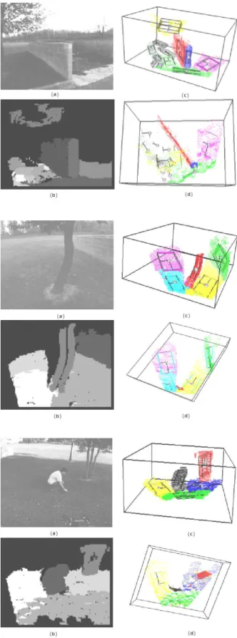
We illustrate in figure 9 the way our methodology processes such 3D point sets with :
heuristic parameters PAh µ1≤ 5cm
SAh Angle( ~µ2µ3,~ ground) ≤ π/8~
The proposed methodology gives coherent results for the entire scene set, allowing the robot to avoid the obstacles during autonomous navigation, and also the 3D reconstruction of the scenes in terms of obstacle shape and navigable area.
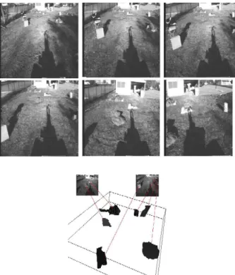
We are also working on large scale environment exploration. Then, the point is to merge the dif-ferent partitioned views of a sequence of 3D point clouds to globally reconstruct the environment as an obstacle map. We worked on a robot which moved straight forward and obtained an initial 3D mesh re-construction of the different obstacles encountered on its path, as illustrated in Figure 10.
5.2
Contest range image database
Figure 11 illustrates the way our methodology pro-cesses such 3D point sets. The P Ah heuristic only was used with a 1cm threshold for planar tests.
The evaluation of the proposed methodology is also performed following the methodology of Hoover et al. [3]. The evaluation methods involves 30 struc-tured light scanner images (ABW set) which were segmented using CAD models of the objects in or-der to obtain ground truth (GT ) images. A tool tries to objectively compare the machine segmenta-tion (M S) to the corresponding GT image using a set of defined performance metrics for instances of correctly segmented, missed and noise regions, over
Figure 10: Sequence of scenes captured by LAMA robot moving straight forward and obstacle map wih 3D-meshed reconstructed structures.
and undersegmentation, and accuracy of the recov-ered geometry. For the sake of comparaison, we im-plement some post-processing: for instance, our al-gorithm automatically merges ground planes, which is a better performance in terms of interpretation, but it would yield undersegmentation results in the Hoover frame.
Figure 11: Different steps of incremental partitioning of a polyhedrical range image.
Numerous research teams have attempted to
compare their segmentation algorithm using this database. Following [7], we propose some quanti-tative results as illustrated in Table 1. Numbers are averages over the set of images : on an average im-age, there are 15.2 GT regions.
research group GT regions correct detection angle diff. (std. ev.) USF 15.2 12.7 1.6 (0.8) WSU 15.2 9.7 1.6 (0.7) UB 15.2 12.8 1.3 (0.8) UE 15.2 13.4 1.6 (0.9) UBham 15.2 13.4 1.6 (0.9) UP5 15.2 12.2 1.7 (0.9) research group over-segment. under-segment. missed noise USF 0.2 0.1 2.1 1.2 WSU 0.5 0.2 4.5 2.2 UB 0.5 0.1 1.7 2.1 UE 0.4 0.2 1.1 0.8 UBham 0.4 0.3 0.8 1.1 UP5 0.3 0.1 2.6 2.2
Table 1: Quantitative comparison with other seg-mentation results
These tables show the good quantitative perfor-mances of our algorithm (UP5 results) even though they do not surpass the correct detection rates of UB and Ubham. However, the other algorithms were specifically designed for this contest: they pro-vide segmentation results in the case of range im-ages which are structured depth information. As a matter of fact, segmentation is performed on depth or disparity maps which are classical 2D intensity images with neighbourhood relationships. Our algo-rithm performs as well on such organised data as on unorganised geometric point sets. It performs par-titionning much more than segmentation. In this sense, it outperforms the other algorithms by the weak hypothesis on data, and so by its genericity. Besides, the Hoover tool is not as objective as it is said to be. Actually, the relative loss of performance comes mostly from the missed or noise regions which are subtracted from the score of correct detection. This means that whatever the size of the missed re-gion, it counts plus one in the score of missed detec-tion and minus one for the score of correct detecdetec-tion. In fact, we observe that most of our missed regions are little regions - that our fuzzy modelling considers as outliers and - whose detection can be controlled by internal parameters but whose importance is ac-tually not so obvious.
6
Conclusion
Basically, we sought to answer a difficult method-ological problem in computer vision: how to develop generic tools for point set partitionning in the field of computer vision. The word generic here means able to easily adapt itself not only to new data with new characteristics but also to new goals with new specifications.
This generic aspect is performed in the context of knowledge-based systems as illustrated in fig-ure 12. The inference motor acts independently of the knowledge module. A specific algorithm called U P F − ON C was used as “cluster maker”. In par-allel, a set of heuristics is fed to incorporate either basic knowledge on expected cluster characteristics depending on the specific application, or more com-plex knowledge models if available.
' & $ % Point sets @ @ @ ' & $ % UFP-ONC algorithm ' & $ % Heuristics set
Figure 12: Knowledge-based system paradigm for point set analysis
First experiments show qualitatively that this flexibility makes it possible to deal with any kind of unorganised point sets for any application. They also yield good quantitative results after comparison with results coming from an international range seg-menter contest.
Further experiments and real implementation on a robot for obstacle avoidance are planned. A recog-nition module of obstacles based on the point set analysis is also under consideration.
Basically, we think that it is a promising step towards modeling large scale environments.
Acknowledgements : This work is supported by the firm EADS (French Air-space Society). The author would like to thank Nicole Cambou and Si-mon Lacroix for their support.
References
[1] R. Chaine and S. Bouakaz. Analyse surfacique de donnes 3-d non structures : une approche basee sur les graphes. In RFIA, pages 37–46, 2000.
[2] H. Edelsbrunner and E.P. Mcke. Three-dimensionnal alpha-shapes. ACM Transactions on Graphics, 13(1):43–72, 1994.
[3] A. Hoover et al. An experimental comparison of range image segmentation algorithms. IEEE Trans. Pattern Analysis and Machine Intelli-gence, 18(7):673–689, july 1996.
[4] Z. Tu F. Han and S-C. Zhu. A stochastic al-gorithm for 3d scene segmentation and recon-struction. In European Conf. on Computer Vi-sion, pages 502–516, Copenhagen, Denmark, May 2002.
[5] I. Gath and A.B. Geva. Unsupervised opti-mal fuzzy clustering. PAMI, 11(7):773–781, july 1989.
[6] X.Y. Jiang and H. Bunke. Fast segmentation of range images into planar regions by scan line grouping. Machine Vision and Application, 7(2):115–122, 1994.
[7] Klaus Kster and Michael Spann. Mir: An approach to robust clustering - application to range image segmentation. IEEE Trans. Pattern Analysis and Machine Intelligence, 22(5):430–443, may 2000.
[8] N. Lom´enie, L. Gallo, N. Cambou, and G. Sta-mon. Structuration plane d’un nuage de points 3d non structur´e et d´etection des zones d’obstacle. In Vision Interface, Trois-Rivieres, Canada, may 1999.
[9] N. Lom´enie, Laurent Gallo, N. Cambou, and G. Stamon. Morphological operators on rep-resentations based on delaunay triangulation. In Proc. International Conference on Pattern Recognition, pages 556–559, Barcelona, Spain, september 2000.
[10] I. Stamos and M. Leordeanu. Automated feature-based range registration of of urban scenes of large scale. In Int. Conf. on Computer Vision and Pattern Recognition, pages 555–561, Madison, WI, June 2003.