HAL Id: hal-00331126
https://hal.archives-ouvertes.fr/hal-00331126
Submitted on 18 Oct 2006HAL is a multi-disciplinary open access
archive for the deposit and dissemination of sci-entific research documents, whether they are pub-lished or not. The documents may come from teaching and research institutions in France or abroad, or from public or private research centers.
L’archive ouverte pluridisciplinaire HAL, est destinée au dépôt et à la diffusion de documents scientifiques de niveau recherche, publiés ou non, émanant des établissements d’enseignement et de recherche français ou étrangers, des laboratoires publics ou privés.
The improvements of the Ships Of Opportunity
Program in MFSTEP
G. M. R. Manzella, F. Reseghetti, G. Coppini, M. Borghini, A. Crusado, C.
Galli, I. Gertman, T. Gervais, D. Hayes, C. Millot, et al.
To cite this version:
G. M. R. Manzella, F. Reseghetti, G. Coppini, M. Borghini, A. Crusado, et al.. The improvements of the Ships Of Opportunity Program in MFSTEP. Ocean Science Discussions, European Geosciences Union, 2006, 3 (5), pp.1717-1746. �hal-00331126�
OSD
3, 1717–1746, 2006 Mediterranean Ships Of Opportunity Program G. M. R. Manzella et al. Title Page Abstract Introduction Conclusions References Tables Figures J I J I Back Close Full Screen / EscPrinter-friendly Version Interactive Discussion
EGU
Ocean Sci. Discuss., 3, 1717–1746, 2006 www.ocean-sci-discuss.net/3/1717/2006/ © Author(s) 2006. This work is licensed under a Creative Commons License.
Ocean Science Discussions
Papers published in Ocean Science Discussions are under open-access review for the journal Ocean Science
The improvements of the Ships Of
Opportunity Program in MFSTEP
G. M. R. Manzella1, F. Reseghetti1, G. Coppini2, M. Borghini3, A. Crusado4, C. Galli3, I. Gertman5, T. Gervais6, D. Hayes9, C. Millot6, E. ¨Ozsoy7, C. Tziavos8, Z. Velasquez4, and G. Zodiatis9
1
ENEA CLIM, Forte S.Teresa. Pozzuolo, 19 036 Lerici, Italy
2
INGV, Bologna, Italy
3
CNR ISMAR, Sezione di La Spezia, Pozzuolo, 19 036 Lerici, Italy
4
CSIC CEAB, Salida S.Antonio S/N, Blanes, Spain
5
IOLR, Haifa,Israel
6
CNRS LOB COM, 83 507 La Seyne-sur-mer, France
7
IMS METU, Erdemly, Turkey
8
HCMR, Athens, Greece
9
Oceanography Centre, University of Cyprus, Nicosia, Cyprus
Received: 9 May 2006 – Accepted: 10 June 2006 – Published: 18 October 2006 Correspondence to: G. M. R. Manzella ([email protected])
OSD
3, 1717–1746, 2006 Mediterranean Ships Of Opportunity Program G. M. R. Manzella et al. Title Page Abstract Introduction Conclusions References Tables Figures J I J I Back Close Full Screen / EscPrinter-friendly Version Interactive Discussion
EGU
Abstract
The Ships Of Opportunity Program in the Mediterranean Sea was established at the end of 1999, in the framework of the Mediterranean Forecasting System – Pilot Project (MFS-PP). Many improvements have been made in data collection, transmission and management. Calibration of selected XBTs and a comparison of XBTs vs. CTDs
5
during some research cruises have assured the quality of the data. Transmission now allows receiving data in full resolution by using GSM or satellite telecommunication services; management is offering access to high quality data and view services. The effects of technological and methodological improvements in the observing system are assessed in terms of capability to represent the most important circulation features.
10
The improved methodologies have been tested during the Mediterranean Forecasting System – Toward Environmental Prediction (MFS-TEP) – Targeted Operational Period (MFS-TOP), lasting from September 2004 to February 2005. In spite of the short period of measurements, several important aspects of the Mediterranean Sea circulation have been verified, such as eddies and gyres in the various sub-basins, and dense water
15
formation processes in some of them (vertical homogeneous profiles of about 13◦C down to ∼800 m in the Provencal, and of about 14.9◦C down to ∼300 m in the Levantine have allowed defining an index of dense water formation).
1 Introduction
A Ships Of Opportunity Program (SOOP) was established in the Mediterranean in
20
September 1999, on behalf of the EC funded project Mediterranean Forecasting Sys-tem – Pilot Project (MFS-PP, Pinardi et al., 2003). Temperature-XBT profiles were collected along six transects crossing the western and the eastern basins from North to South and one transect crossing the whole sea from east to west. These
tran-OSD
3, 1717–1746, 2006 Mediterranean Ships Of Opportunity Program G. M. R. Manzella et al. Title Page Abstract Introduction Conclusions References Tables Figures J I J I Back Close Full Screen / EscPrinter-friendly Version Interactive Discussion
EGU
sects were designed to specify, in each of the sub-basins1(the Algero-Provencal, the Tyrrhenian, the south Adriatic, the Ionian and the Levantine), the variability of the main circulation features ( ¨Ozsoy et al., 1991, 1993; POEM Group, 1992; Fusco et al, 2003; Zodiatis et al., 2005a; Millot and Taupier-Letage, 2005a).
The program provided data that were assimilated in the Modular Ocean Model
5
(MOM), used in MFS-PP for forecasting the physical properties of the Mediterranean Sea (Pinardi et al., 2003; Demirov et al., 2003). The data allowed also updating the general circulation scheme of the sea (Manzella et al., 2001).
In the first phase of MFS-PP, the technology was the same as that used in the inter-national SOOP program (Smith et al., 2000), Sippican XBTs (T7 essentially, maximum
10
depth 760 m) for data acquisition and ARGOS for data transmission. The tempera-ture profiles were sub-sampled by the ARGOS software and coded for transmission on the GTS (Global Telecommunications System) in the BATHY format (AODC, 1999; AODC, 2001; Cook and Sy, 2001). The quality control procedures were slightly mod-ified to take into account the physical characteristics of the Mediterranean: no test in
15
the upper 5 m, minimum temperature of 2◦C, maximum temperature of 34◦C, maximum temperature inversion in the upper 200 m of 4.5◦C, maximum temperature inversion below 200 m of 1.5◦C and maximum temperature gradient of 3◦C. The changes were operated essentially to specify a) the characteristics of the relatively warm Levantine Intermediate Water (LIW), b) the thickness of the water of Atlantic origin (AW) and c)
20
the vertical homogeneity associated with the dense water formation process (Manzella et al., 2003).
This approach had some significant inconveniences, since the sub-sampled data could lead to losses, inter alia, of signals related to the core properties of most of the Mediterranean waters, corresponding to the strong thermocline during summer and
25
to the relative increase of temperature associated with LIW. Furthermore the meta-information contained in the transmitted file only had an approximate value of the
1
Note the specific use of terms such as sea, basin and sub-basin, following Millot and Taupier-Letage (2005a).
OSD
3, 1717–1746, 2006 Mediterranean Ships Of Opportunity Program G. M. R. Manzella et al. Title Page Abstract Introduction Conclusions References Tables Figures J I J I Back Close Full Screen / EscPrinter-friendly Version Interactive Discussion
EGU
launch position.
Data transmission was achieved using a normal GSM phone / modem for Internet connection. The edf – full resolution Sippican files were compressed and sent attached to an e-mail. This simple improvement was made possible by the GSM coverage avail-able in the Mediterranean region. Transmitting the full resolution profiles needed to
5
change the quality control (QC) procedures. The software developed was based on Medar-Medatlas protocols (MedAtlas Group, 1994) and contained all the steps of the delayed mode quality control: gross range check, position control, elimination of spikes, re-sampling at 1 m interval, gaussian smoothing, general malfunction control, compar-ison with climatology. Two visual checks were added at the beginning and at the end
10
of the QC procedure, in order to detect the end of a given profile and look at the overall consistency of the profiles (Manzella et al., 2003).
The improved data transmission and quality control was applied to all projects that followed MFS-PP. From September 1999 to June 2005 the Mediterranean SOOP has provided more than 9000 XBT profiles that have been assimilated in numerical models
15
forecasting the Mediterranean Sea circulation. The database offers also the possibility to study seasonal and inter-annual variability. The program is now evolving into a full Volunteer Observing Ships (VOS) system providing sea-temperature profiles and meteorological data. For this reason it will be briefly named as MFS-VOS hereafter.
The project Mediterranean Forecasting System – Toward Environmental Prediction
20
(MFS-TEP) has provided the opportunity to test the two main elements of MFS-VOS:
– the data collection strategy (including sampling design, technologies for data
col-lection and for data transmission)
– the near-real time (NRT) data management (including NRT QC, and data access)
The main objective of the project was the development of an efficient data collection
25
and management system for its transformation into an operational, more automated and multi-parametric VOS system.
OSD
3, 1717–1746, 2006 Mediterranean Ships Of Opportunity Program G. M. R. Manzella et al. Title Page Abstract Introduction Conclusions References Tables Figures J I J I Back Close Full Screen / EscPrinter-friendly Version Interactive Discussion
EGU
– the data collection system in order to define the long term design – the methodologies and strategies for the future operational system. – the quality of services provided (i.e. quality of data and easy access)
The paper is presenting the materials and methods used in MFS-TEP (Sect. 2) and the analysis of procedures for data processing (Sect. 3), which includes also the
ca-5
pability of the observing system to specify the main circulation features of the Mediter-ranean Sea. The services provided by MFS-VOS are presented in Sect. 4, and discus-sion and concludiscus-sions are in Sect. 4 as well.
The data collection in MFS-TEP started in May 2004 along some transects and the observing system was fully operational during the so-called TOP from September 2004
10
to February 2005. The paper presents mainly the TOP data, although data collection is continuing along some transects.
2 Materials and methods
The main requirements of the SOOP were defined in MFS-PP. An ideal sampling de-sign is based on four goals:
15
– provide repetitive measurements along transects from coast to coast, – the transects must cross significant dynamical features of the circulation, – the sampling distance should resolve, as well as possible, the mesoscale,
– the technologies for data collection must be robust and simple, to be used on
ships of opportunity, eventually by ship personnel.
20
The experience of MFS-PP indicated that there was a need for technology allowing full resolution data and metadata transmission in order to avoid wrong interpolations and misinterpretation of the ocean dynamics.
OSD
3, 1717–1746, 2006 Mediterranean Ships Of Opportunity Program G. M. R. Manzella et al. Title Page Abstract Introduction Conclusions References Tables Figures J I J I Back Close Full Screen / EscPrinter-friendly Version Interactive Discussion
EGU
Other requirements were defined in MFS-TEP, in terms of services to be provided to the forecasting systems as well as to intermediate and end users:
– intermediate users need QC data for their particular goals, as they are producers
of other services and the access to data should be based on mutual satisfaction;
– end users are interested in products (e.g. maps of data, changes with respect to
5
climatology, etc.). The satisfaction of end users is of paramount importance to sustain the observing system.
In order to fulfil these requirements, some technological and methodological ap-proaches were selected.
2.1 Technology for data acquisition and transmission
10
Temperature profiles were obtained by using Sippican systems composed of Deep Blue, T7 and T4 XBT probes, a hand launcher, a MK12 or MK21 card, a GPS and a PC. The Sippican software was set to extend the nominal depth for the data collection from 760 m to about 1000 m for Deep Blue and T7 and from 460 to 600 m for T4 so that it was possible to use more extensively the copper wire in the probes. Usually
15
good temperature data were obtained down to about 900 m for Deep Blue and T7, and to about 550 m for T4. Another small improvement was the use, in some cases, of “industrial computers” in order to have a better portability of the data collection system. From the beginning of the MFS-TEP – VOS the data transmission was done with GSM card or telephone used as modem. After collection, the data were zipped and
20
transmitted as an e-mail, as soon as possible, i.e. when the GSM signal was good for an Internet connection. After Spring 2005, satellite telecom system was tested. The Globalstar was selected since it was offering good transmission rate and cover-age. This transmission is now used during “cruises of opportunity” (COP), i.e. research vessels are provided with XBTs for the collection of temperature profiles during their
25
OSD
3, 1717–1746, 2006 Mediterranean Ships Of Opportunity Program G. M. R. Manzella et al. Title Page Abstract Introduction Conclusions References Tables Figures J I J I Back Close Full Screen / EscPrinter-friendly Version Interactive Discussion
EGU
2.2 Sampling design and data collection
Any sampling design of a SOOP is strongly dependent on ship availability and company travel schedules. But there is also another factor affecting the program that is the budget consistency, which dictates limitations and choices to the monitoring system.
The sampling strategy was designed on the experience of MFS-PP. The Table 1
5
is reporting the initial design, the number of XBTs for each transect, and the total of XBTs necessary for TOP, i.e. for a period demonstrating all the potential application of the MFS-VOS system.
In MFS-TEP the data collection started on May 2004, along two transects (Limassol – Port Said and Genova-Palermo). In September 2004 the MFS-TEP – VOS system
10
was fully operational. Some changes were decided in order to improve the observing system and extend it in areas not covered before. Of particular importance was the replacement of the Barcelona-Arzew transect by the Barcelona-Mersa el Brega one. MFS-TEP – VOS system thus allowed collecting data in an area not sampled before for many decades.
15
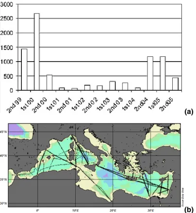
The complete numbers of XBT data collected in the MFS-VOS program from 1999 to June 2005 are shown in Fig. 2a, in particular the MFS-TEP-VOS data collected from May to June 2005 are presented in Fig. 2b. The MFS-TEP-VOS transects were repeated monthly, while the COP transects were occasional.
2.3 Data flow and quality control
20
The raw data collected along each transect are sent to the MFS-VOS Data Centre located in ENEA – La Spezia. The temperature profiles are processed there in near real time with the QC software developed during MFS-PP (Manzella et al., 2003) and implemented in MFS-TEP (Reseghetti et al., this issue). Both raw and QC data are provided on a FTP site that is accessible through the project web pages. During
MFS-25
TEP the data were generally transmitted within 24 h from data collection, by using GSM telephones or cards. The data QC has been done normally within half an hour. The
OSD
3, 1717–1746, 2006 Mediterranean Ships Of Opportunity Program G. M. R. Manzella et al. Title Page Abstract Introduction Conclusions References Tables Figures J I J I Back Close Full Screen / EscPrinter-friendly Version Interactive Discussion
EGU
data collection and control were then organised to deliver data with a relatively short time delay (possibly less than 24 h) and in time for the weekly data assimilation process. Nevertheless, due to constraints such as ships availability, duration of transects and monthly data collection (even the 15-day sampling interval of MFS-PP was not sufficient to resolve the mesoscale (Raicich and Rampazzo, 2003), the sampling was not optimal
5
for a forecasting system.
The quality of data was assured by calibration of some XBTs extracted from different batches in La Spezia NURC (NATO Undersea Research Centre). Static calibration was done at 4 temperatures (12.5, 16.0, 20.0 and 24.0◦C): all measured values were larger than actual ones with maximum differences ranging from 0.04◦C (at 12.5◦C) to 0.08◦C
10
(at 24.0◦C).
3 Capabilities of the observing system
The analysis of the VOS data carried out at the end of MFS-PP (Fusco et al., 2003) gave main results about the capability to provide data in real time for assimilation. Fur-thermore, the data allows defining intra- and inter-annual variability of thermal
struc-15
tures along transects. Circulation features specified in MFS-PP were:
– instability of the circulation of AW having high temporal and spatial variability, but
also long life times and deep extent (i.e. Millot, 1999);
– the location of LIW slope around Sardinia (Millot, 1987);cyclonic
along-slope gyre in the whole northern part of the western basin (Millot, 1999);
20
– doming of isotherms in the central Tyrrhenian in front of the Bonifacio Straits, due
to Ekman pumping (Marullo et al., 1995);
– doming of isotherms in the Ionian, indicating the restoration of the cyclonic
OSD
3, 1717–1746, 2006 Mediterranean Ships Of Opportunity Program G. M. R. Manzella et al. Title Page Abstract Introduction Conclusions References Tables Figures J I J I Back Close Full Screen / EscPrinter-friendly Version Interactive Discussion
EGU
Transient that lasted for the 90’s (Malanotte Rizzoli et al., 1999, Klein et al, 1999; Klein et al., 2000);
– isotherm depression associated to Pelops, Ierapetra and Cyprus and Shikmona
anti-cyclonic eddies (Hecht and Gertman, 2001, Zodiatis et al., 2001; Zodiatis et al. 2005a);
5
– doming of isotherms south of Crete and off Mersa-Matruth.
The particular features detected in the MFS-TEP period are described below, selec-tively using data to illustrate these features. In the past, different schematic descriptions of the Mediterranean circulation have emerged, as a result of particular observations or model realizations ( ¨Ozsoy et al., 1989, 1991, 1993; Robinson et al., 1992, Pinardi et
10
al., 2004; Hamad et al., 2004, Millot and Taupier-Letage, 2005a, Hamad et al., 2005a). It is indeed confirmed by the recent data-driven MFS-TEP forecasts (see monthly bul-letins athttp://www.bo.ingv.it/mfstep/WP8/monthly.htm), that different forms of the pro-posed circulations can be observed at different times. For instance, during the early period of MFS-TEP realizations, the mid-Mediterranean jet (MMJ) has been
consis-15
tenly seen to be an extension of the Ionian stream in the Levantı ne Sea, while at other times it has taken a convoluted form accompanying a more uniform stream along the Libyan-Egyptian coast.
Transect Limassol-Port Said, Limassol-Alexandria (managed by the Oceanographic Centre, University of Cyprus, Fig. 3). During MFS-PP this SE Levantine transect was
20
from Limassol (Cyprus) to Port Said (Egypt). In MFS-TEP, from May 2004 to October 2005, the destination was the same, while in December 2004 and January 2005 the end port was Alexandria. The XBT data collection was extended until October 2005. In May 2004, the transect intersected the centre of the Cyprus warm core eddy. In September and October 2004, February, April and May 2005, the transects intersected
25
the western periphery of the Cyprus eddy due to its eastward drift (as indicated by a depression of the isotherms; Zodiatis et al., 2005a). In December 2004 and January
OSD
3, 1717–1746, 2006 Mediterranean Ships Of Opportunity Program G. M. R. Manzella et al. Title Page Abstract Introduction Conclusions References Tables Figures J I J I Back Close Full Screen / EscPrinter-friendly Version Interactive Discussion
EGU
2005 the transects did not cross the eddy, and homogeneous temperatures as low as 18.5◦C were found down to about 100 m.
Transects Mersin – Ashdod and Alexandria – Rhodes (managed by the Institute of Marine Science, Figs. 4a and 4b). XBT data were collected during the TOP period along a north-south transect east of Cyprus from Mersin to Ashdod, as well as along
5
a transect from Alexandria to Rhodes, the latter one crossing the Rhodes Gyre, a per-manent feature of the Levantine basin. In October 2004, various areas of deepening thermocline depth corresponding to anticyclonic centers were present (Fig. 4a), no-tably the coherent Lattakia eddy, east of Cyprus and also those in the southeast corner of the basin well identified from satellite images. Significant thermal stratification was
10
detected along the transects with the thermocline depth varying from about 100 m in the Egyptian area to 50 m inside the Rhodes Gyre. In December 2004 the thermocline depth was deeper, as a consequence of the atmospheric effects. The vertical homo-geneity of the water mass in the centre of the Rhodes gyre was greater in the upper 300 m in February 2005 (Fig. 4b). The uniform temperatures could be the result of
15
convection leading to dense water formation at the center of the Rhodes Gyre, often extending to greater depths in the colder years as documented by Sur et al. (1992), Lascaratos and Nittis (1998) and Malanotte-Rizzoli et al. (2003).
Transect Heraklion – Thessaloniki (managed by Hellenic Centre for Marine Re-search, Fig. 5). This was another new transect introduced in MFS-TEP, with the aim to
20
monitor an important area where dense water could be formed. The data show always three different waters in the Sporades, central Aegean and Cretan sub-basins (Fig. 5). In the Cretan sub-basin the isotherms were always presenting a depression in the 100– 500 m layer, except in winter (e.g. January 2005) when all transects were presenting a vertical homogeneity. The data collected in the northern part of the section did not
25
present particular features.
Transect Haifa – Messina (managed by Institute of Oceanographic and Limnological Research, Fig. 6). The transect from Haifa to Messina has shown the main features of the eastern basin, such as the Pelops, Ierapetra (south-east of Crete) and
Cyprus-OSD
3, 1717–1746, 2006 Mediterranean Ships Of Opportunity Program G. M. R. Manzella et al. Title Page Abstract Introduction Conclusions References Tables Figures J I J I Back Close Full Screen / EscPrinter-friendly Version Interactive Discussion
EGU
Shikmona anti-cyclones/anticyclones. In October-November and December 2004 the transects crossed the Iera-Petra eddy, presenting thermal depression down to 300 m. The Rhodes Gyre was well evident as well as the Cyprus eddy. West of Crete, the transect intersected the Pelops eddy. In the Ionian the isotherms were presenting a slight surfacing of the thermocline, typical of cyclonic circulation. In January 2005,
5
the eddies and gyres were much more evident. In particular, the Rhodes Gyre was presenting a higher vertical homogeneity, the Cyprus eddy was well developed, as well as the Iera-Petra eddy.
Transect Genova – Palermo (managed by Istituto Scienze Marine – Sezione La Spezia, Fig. 7). This transect started on May 2004 and is still continuing. Data in
10
the Tyrrhenian show the well known Bonifacio Gyre, influenced by the westerly winds (Marullo et al., 1994). In the southern part of the Tyrrhenian, the data have shown a significant variability of the circulation. Sometimes the isotherms were indicating the presence of a cyclonic circulation (e.g. September and December 2004, Febru-ary 2005), in other periods there were indications of a higher spatial variability with
15
cyclonic and anti-cyclonic features. The data in the Ligurian are always indicating a cyclonic circulation whose intensity is varying seasonally.
Transect Marseille – Tunis (managed by Laboratoire d’Oc ´eanologie et de Biog ´eochimie – Antenne de Toulon, Fig. 8). One important feature is the zone of dense water formation in the Provenc¸al (off the Gulf of Lions near 42◦N) where temperatures
20
in February 2005 were homogeneous (13.1–13.2◦C) down to 1000 m (at least). Note that lower temperatures were found in the 100–200 m surface layer mainly more to the south (near ∼41◦N); because waters there have relatively low salinities, they are less dense than near 42◦N and does not mix with the warmer and more saline intermedi-ate wintermedi-aters. Still in the surface layer, note also the relatively large values close to the
25
Tunisian slope (associated with the continuation of the Algerian Current) and the rela-tively low ones close to the French slope (associated with the Northern Current) which both sign the baswide alongslope gyre (see Millot and Taupier-Letage, 2005a). At in-termediate depths, the relative maxima found alongslope (at ∼300 m south and west off
OSD
3, 1717–1746, 2006 Mediterranean Ships Of Opportunity Program G. M. R. Manzella et al. Title Page Abstract Introduction Conclusions References Tables Figures J I J I Back Close Full Screen / EscPrinter-friendly Version Interactive Discussion
EGU
Sardinia and ∼500 m off France) clearly trace the alongslope circuit of LIW as specified by Millot(1987; see consistency with other transects too).
Transect Barcelona – Mersa el Braga (managed by Centre de Etudis Advancat de Blanes, Fig. 9). This transect substituted the original Barcelona – Arzew transect in November 2004, end of January and February 2005. The Algerian was presenting
5
a high spatial variability, as depicted in the circulation scheme by Millot (1999). The importance of this transect, lies in the fact that data have been collected in the southern Ionian for the first time after many years. There are some important patterns that are worthy of attention, such as the entrance of relatively warm water at about 140 m from the Ionian, visible from 35◦N to North of Tunisia coast . Also some eddies were
10
observed in the Gulf of Syrta, as first depicted by Hamad et al. (2004) and detailed in Hamad et al. (2005b).
Transect Barcelona – Arzew (managed by Centre de Etudis Advancat de Blanes, Fig. 10). This was done in alternative to the previous transect and show the north-ern part of the along slope Northnorth-ern Current and the instabilities in the eastnorth-ern Alboran
15
Sea). A surfacing of the thermocline was observed in September, October and Novem-ber 2004 between the Balearic Islands and Algeria, but no other significant features were observed. At intermediate depths (200–400 m), the relatively large temperatures associated with LIW are found along the Spanish continental slope. In the Algerian sub-basin, largest temperatures are found offshore (near 37◦N), and could be associated
20
to LIW transported slope by Algerian eddies (Millot, 1987; Millot and Taupier-Letage, 2005b).
The data collected by using the Italian vessel Urania are not commented, but are used for the derivation of the general circulation scheme during MFS-TEP. There have been also additional cruises done in the same data collection period in some
sub-25
basins, such as those of CYBO (Cyprus Basin Oceanography) in the Levantine, which are used to comment the MFS-TEP – VOS data.
In October 2004 it was detected the cyclonic Alboran Gyre (that is normally an anti-cyclonic circuit) closer to Gibraltar followed by an anti-anti-cyclonic gyre to the east. This
OSD
3, 1717–1746, 2006 Mediterranean Ships Of Opportunity Program G. M. R. Manzella et al. Title Page Abstract Introduction Conclusions References Tables Figures J I J I Back Close Full Screen / EscPrinter-friendly Version Interactive Discussion
EGU
situation is not usual, since the first anticyclonic gyre is normally followed by a sec-ond one, but the data interpretation is also in agreement with MFSTEP analysis (MF-STEP Bulletin, October 2004), although some other interpretations could be possible, i.e. a cyclone between two anti-cyclones. The instabilities associated with the Algerian current are normally interesting the upper 100–200 metres (Millot and Taupier-Letage,
5
2005). However, a deep anti-cyclonic eddy was detected at about 6◦E. CTD data col-lected in the same area by Urania show that the eddy is deeper than 1000 metres (consistent with previous data and e.g. Millot and Taupier-Letage, 2005b). Instabilities associated with the AW were influencing, as expected, also the circulation in the Sar-dinia Channels. The cyclonic circulation in the Gulf of Lion and in the Ligurian Sea
10
was detected as usual, as well as the Gyre of Bonifacio. In the eastern basin the main features are represented by the anti-cyclonic circulation in the Ionian, the Pelops, Iera-Petra and Cyprus eddies. It was also evident the cyclonic Rhodes Gyre and the anti-cyclonic circulation in the Mersa-Matruh area.
In January 2005 the transects in the western basin show a cyclonic pattern between
15
the Balearic Islands and Spain and some eddies in the Algero-Provencal basin. The most important feature was found in the Gulf of Lion where the surface temperatures was relatively cold (less than 13◦C) and the profiles are indicating the reinforcement of the cyclonic circulation and the establishment of deep convection. The Bonifacio Gyre was stronger than in other periods. In the eastern basin data show a cyclonic
circula-20
tion in the Ionian Sea and entrance of Ionian water in the Channel of Sicily at 140 m depth. Pelops and Iera-Petra anti-cyclones were always detected, as well as a stronger Rhodes gyre. More different is the pattern in the south-east portion of the Levantine basin where the Cyprus eddy was found closer to the Asian coast, and Mersa-Matruh more north. The combination of data collected from 1999 to now, demonstrate that
25
the variability in the south-east Levantine basin is greater than believed in the 90’s (Malanotte-Rizzoli et al., 1999). In particular, the Cyprus coherent eddy Gyre appears sometimes as a large and intense anticyclones, in other periods, normally in summer, the gyre is lesser well defined (Zodiatis et al., 2005).
OSD
3, 1717–1746, 2006 Mediterranean Ships Of Opportunity Program G. M. R. Manzella et al. Title Page Abstract Introduction Conclusions References Tables Figures J I J I Back Close Full Screen / EscPrinter-friendly Version Interactive Discussion
EGU
Particular aspects that were investigated in this analysis are the circulation features in the eastern basin, using the results obtained from new hydrological cruises carried out almost in parallel with MFS-TEP-VOS. In mid 80’s the SE Levantine mesoscale flow structure was described to consist among other dynamic features, of a permanent anticyclonic warm core eddy south of Cyprus (Hecht et al., 1988; Brenner, 1989),
5
named it as the Cyprus eddy. Analysis carried out on data collected in late 80’s during POEM cruises identified an area of non-permanent multi-pole gyre, named Shikmona Gyre with a flow jet (the Mid Mediterranean Jet–MMJ) transferring AW from west to east (e.g. ¨Ozsoy et al, 1989; POEM Group, 1992; Malanotte Rizzoli et al., 1994). During POEM cruise it was found that this gyre encompassed three eddies with the
10
northernmost constituting the Cyprus warm core eddy (Ozsoy et al, 1989). From mid 90’s to 00’s new high resolution seasonal in-situ data collected in the framework of CYBO and CYCLOPS (Cycling of Phosphorus in the Mediterranean) projects showed strong seasonal and spatial variability of the permanent Cyprus warm core eddy, the re-establishment for a certain period of the Shikmona Gyre (Zodiatis et al., 2005a,
15
Groom et al., 2005) and of the confirmation that the MMJ is the main flow path of the AW in the SE Levantine ( ¨Ozsoy et al, 1989, 1991, 1993; Zodiatis et al., 2005b).
4 Discussion and conclusions
The Ships Of Opportunity Program started in the Mediterranean in September 1999, and since that time has continued to provide XBT-temperature profiles. The objective of
20
the program is the provision of quality data to the Mediterranean Forecasting System and to other external users. For this reason, some quality control procedures were implemented, such as: quality assurance of fieldwork and quality control of data.
In order to fulfil the scope, many implementations have been introduced in the data collection, transmission and management. The implementations have been the result
25
OSD
3, 1717–1746, 2006 Mediterranean Ships Of Opportunity Program G. M. R. Manzella et al. Title Page Abstract Introduction Conclusions References Tables Figures J I J I Back Close Full Screen / EscPrinter-friendly Version Interactive Discussion
EGU
– In order to assure a high quality to data, selected probes from different batches
have been calibrated at the NURC centre in La Spezia, at different reference temperatures. The precision of the temperature measurements as deduced from the static calibration is of 0.04–0.08◦C.
– The XBT probes are used in an ‘extensive’ mode, i.e. the Sippican software is set
5
in a way that the data can be collected below the nominal depth (Reseghetti et al., this issue). With Deep Blue probes it is thus possible to measures down to about 900 m. This small implementation allows inferring more information on the deeper stratification in the Mediterranean.
– Full resolution data are transmitted by using GSM or satellite telecom systems
10
(Globalstar). This avoid the loose of information in the temperature profiles (Manzella et al., 2003) and in the metadata.
– Data are transmitted as an e-mail to the MFS-VOS Thematic Centre, where they
are processed and included in a ftp site, where they can be accessed by any user. The protocols and methodologies for data collection, transmission and quality control
15
have been definitively tested in MFSTEP, checking that the monitoring system is ade-quate to specify the main circulation features of the Mediterranean and their variability. Meanwhile, some basic services have been developed, in order to allow users to have general information on data and thermal variability in the Mediterranean.
The system is now mature to move from a pre-operational project to a full
opera-20
tional phase. This will be done in two ways: selecting the most significant transects, and improving the technology for an improved two-way automated data collection and transmission system.
The passage from the pre-operational to the operational phase must include also the implementation of services for users. MFS-VOS is providing data to forecasting system
25
and, through the acquisition of long time series, to climatic studies. However, this is not exhausting the scope of MFS-VOS. Data have a value per se, and many products
OSD
3, 1717–1746, 2006 Mediterranean Ships Of Opportunity Program G. M. R. Manzella et al. Title Page Abstract Introduction Conclusions References Tables Figures J I J I Back Close Full Screen / EscPrinter-friendly Version Interactive Discussion
EGU
can be derived from them, such as inter alia): maps on the thermal state of the sea, differences with respect to climatology, implemented climatologies.
Acknowledgements. MFS-VOS has been supported by the EC project MFSTEP under contract
EVK3-CT-2002-00075, and the UNESCO – Italian Ministry of Foreign Affairs – Italian Ministry of Territory and Environment project ADRICOSM EXT. The authors are indebted with owners,
5
captains and crews of the following ships: Britain Star (Zim Company), Annabella, Methane Polar and Methane Arctic (CS/Osprey), Mont Ventoux (Delom), Excellent, La Superba and La Suprema (Grandi Navi Veloci), M. Kalkavan (Turkon), Princesa Marissa and Serenade (Louis Company), Celtic Ambassador (Zim Company) and EAS (EDT Offshore), Daedalos (Daedalos). Authors acknowledge Mrs G. Muzio from Grandi Navi Veloci, E. Lazzoni and F. Dell’Amico from
10
CNR-ISMAR-SP, M. Morgigni from ENEA, M. Demirel from the IMS-METU, and M. Ioannou and S. Savva from the Cyprus Oceanography Centre for the assistance and efforts during the data collection. The free software Ocean Data View by R. Schlitzer is extensively used in MFS-VOS.
References
AODC: Guide to MK12 – XBT System (Including Launching, returns and faults), Australian
15
Oceanogr. Data Centre (AODC), METOC Services, 1–63, 1999.
AODC: Expendable Bathythermographs (XBT) delayed mode. Quality control manual, Aus-tralian Oceanogr. Data Centre (AODC), Data Management Group, Technical Manual 1/2001, 1–24, 2001.
Brenner, S.: Structure and evolution of warm core eddies in the Eastern Mediterranean
Levan-20
tine Basin, J. Geophys. Res., 94, 12 593–12 602, 1989.
Cook, S. and Sy, A.: Best guide and principles manual for the Ships Of Opportunity Program (SOOP) and EXpendable Bathythermograph (XBT) operations. Prepared for the IOC-WMO-3rd Session of the JCOMM Ship of Opportunity Implementation Panel (SOOPIP-III), March 28–31, 2000, La Jolla, California, U.S.A., 1–26, 2001.
25
Demirov, E., Pinardi, N., Fratianni, C., Tonani, M., Giacomelli, L., and DeMey, P.: Assimila-tion scheme of the Mediterranean Forecasting System: operaAssimila-tional implementaAssimila-tion, Ann. Geophys., 21, 189–204, 2003.
Fusco, G., Manzella, G. M. R., Cruzado, A., Gacic, M., Gasparini, G. P., Kovacevic, V., Mil-lot, C., Tziavos, C., Velasquez, Z., Walne, A., Zervakis, V., and Zodiatis, G.: Variability of
OSD
3, 1717–1746, 2006 Mediterranean Ships Of Opportunity Program G. M. R. Manzella et al. Title Page Abstract Introduction Conclusions References Tables Figures J I J I Back Close Full Screen / EscPrinter-friendly Version Interactive Discussion
EGU
mesoscale features in the Mediterranean Sea from XBT data analysis, Ann. Geophys., 21, 21–32, 2003.
Gascard, J. C.: Mediterranean deep water formation, baroclinic instability and oceanic eddies, Oceanol. Acta, 1, 3, 315–330, 1978.
Groom, S., Herut, B., Brenner, S., Zodiatis, G., Psarra, S., Kress, N., Krom, M. D., Law, C. S.,
5
and Drakopoulos, P.: Satellite derived spatial and temporal biological variability in the Cyprus Eddy, Deep Sea Res., II, 52, 2990–3010, 2005.
Hamad, N., Millot, C., and Taupier-Letage, I.: The surface circulation in the eastern basin of the Mediterranean Sea: new elements, Proceeding of the Ankara Conference, October 2002, 2–9, 2004.
10
Hamad, N., Millot, C., and Taupier-Letage, I.: A new hypothesis about the surface circulation in the eastern basin of the Mediterranean Sea, Prog. Oceanogr. , 287–298, 2005a.
Hamad, N., Millot, C., and Taupier-Letage, I.: The surface circulation in the eastern basin of the Mediterranean Sea, Scientia Marina, in press, 2005b.
Hecht, A., Robinson, A., and Pinardi, N.: Currents, water masses, eddies and jets in the
15
Mediterranean Levantine basin, J. Phys. Oceanogr., 8, 1320–1353, 1988.
Hecht, A. and Gertman, I.: Physical features of the eastern Mediterranean resulting from the integration of POEM data with Russian Mediterranean cruises, Deep-Sea Res. I, 48, 1847– 1876, 2001.
Klein, B., Roether, W., Manca, B. B., Bregant, D., Beitzel, V., Kovacevic, V., and Lucchetta, A.:
20
The large deep water transient in the eastern Mediterranean, Deep Sea Res. I, 46, 371–414, 1999.
Klein, B., Roether, W., Civitarese, G., Gacic, M., Manca, B. B., and Ribera d’Alcal `a, M.: Is the Adriatic returning to dominate the production of Eastern Mediterranean Deep Water?, Geophys. Res. Lett., 27, 3377–3380, 2000.
25
Lascaratos, A. and Nittis, K.: A high resolution 3-D numerical study of intermediate water formation in the Levantine Sea, J. Geophys. Res., 103, 18 497–18 511, 1998.
Leaman, K. D. and Schott, F.: Hydrographic structures of the convection regime in the Gulf of Lions, winter 1987, J. Phys. Oceanogr., 21, 575–598, 1991.
Malanotte–Rizzoli, P., Manca, B. B., Ribera d’Alcal `a, M., Theocaris, A., Brenner, S., Budillon,
30
G., and ¨Ozs ¨oy, E.: The eastern Mediterranean in the 80s and in the 90s: the big transition in the intermediate and deep circulation, Dynam. Atmos. Oceans, 29, 365–395, 1999.
OSD
3, 1717–1746, 2006 Mediterranean Ships Of Opportunity Program G. M. R. Manzella et al. Title Page Abstract Introduction Conclusions References Tables Figures J I J I Back Close Full Screen / EscPrinter-friendly Version Interactive Discussion
EGU
Water Experiment (LIWEX) Group: Levantine basin – A laboratory for multiple water mass formation processes, J. Geophys. Res. Oceans, 108(C9), 8101, doi:10.1029/2002JC001643, 2003.
Manzella, G. M. R., Cardin, V., Cruzado, A., Fusco, G., Gacic, M., Galli, C., Gasparini, G. P., Gervais, T., Kovacevich, V., Millot, C., Petit de la Villeon, L., Spaggiari, G., Tonani, M.,
Tzi-5
avos, C., Velasquez, Z., Walne, A., Zervakis, V., and Zodiatis G.: Project improves monitoring of circulation variability in the Mediterranean Sea, EOS, 497–504, 2001.
Manzella, G. M. R., Scoccimarro, E., Pinardi, N., and Tonani, M.: Improved near real time data management procedures for the Mediterranean ocean Forecasting System – Voluntary Observing Ship program, Ann. Geophys., 21, 21–32, 2003.
10
Marullo, S., Santoleri, R., and Bignami F.: The surface characteristics of the Tyrrhenian Sea: historical satellite data analysis, in: Seasonal and Interannual variability of the Western Mediterranean Sea, AGU Coastal and estuarine studies 46, edited by: La Violette, P. E., 135–154, 1995.
MedAtlas Group: Specification for Mediterranean banking and regional quality controls,
IFRE-15
MER, Direction Scientific, Sismer-Brest, SISMER/IS/94-014, 29, 1994.
Millot, C.: The circulation of the Levantine Intermediate Water in the Algerian Basin, J. Geophys. Res., 92, C8, 8265–8276, 1987.
Millot, C.: Circulation in the Western Mediterranean Sea, J. Marine Syst., 20, 1–4, 423–442, 1999.
20
Millot, C. and Taupier-Letage, I.: Circulation in the Mediterranean Sea. The handbook of envi-ronmental chemistry, Vol K ,(The Natural Environment and the Biological Cycles), Springer-Verlag Editor, 29–66, 2005a.
Millot, C. and Taupier-Letage, I.: Additional evidence of LIW entrainment across the Algerian Basin by mesoscale eddies and not by permanent westward-flowing vein, Prog. Oceanogr.,
25
231–250, 2005b. ¨
Ozsoy, E., Hecht, A., and ¨Unl ¨uata, ¨U.: Circulation and hydrology of the Levantine Basin. Results of POEM Coordinated Experiments 1985–1986, Prog. Oceanogr., 22, 125–170, 1989. ¨
Ozsoy, E., Hecht, A., ¨Unl ¨uata, ¨U., Brenner, S., Ouz, T., Bishop, J., Latif, M. A., and Rosentroub, Z.: A review of the Levantine Basin circulation and its variability during 1985–88, Dyn. Atmos.
30
Oceans, 15, 421–456, 1991. ¨
Ozsoy, E., Hecht, A., ¨Unl ¨uata, ¨U., Brenner, S., Sur, H.., Bishop, J., Latif, M. A., Rozentraub, Z., and Ouz, T.: A synthesis of the Levantine Basin circulation and hydrography, 1985–1990,
OSD
3, 1717–1746, 2006 Mediterranean Ships Of Opportunity Program G. M. R. Manzella et al. Title Page Abstract Introduction Conclusions References Tables Figures J I J I Back Close Full Screen / EscPrinter-friendly Version Interactive Discussion
EGU
Deep-Sea Res., 40, 1075–1119, 1993.
Pinardi, N., Allen, I., Demirov, E., DeMey, P., Korres, G., Lascaratos, A., LeTraon, P. Y., Maillard, C., Manzella, G., and Tziavos, C.: The Mediterranean ocean Forecasting System: first phase of implementation (1998–2001), Ann. Geophys., 21, 3–20, 2003.
POEM Group: General Circulation of the Eastern Mediterranean Sea, Earth Sci. Rev., 32,
5
285–309, 1992.
Raicich, F. and Rampazzo, A.: Observing system simulation experiments for the assessment of temperature sampling strategies in the Mediterranean Sea, Ann. Geophys., 21, 151–166, 2003.
Roether, W., Manca, B. B., Klein, B., Bregant, D., Georgopoulos, D., Beitzel, V., Kovacevich,
10
V., and Luchetta, A.: Recent changes in the eastern Mediterranean deep water, Sci., 271, 333–335, 1996.
Smith, N. R., Harrison, D. E., Bailey, R., Delcroix, T., Hanawa, K., Keely, B., Meyers, G., Molinari, B., and Roemmich, D.: The role of XBT sampling in the ocean thermal network, OCEANOBS St Raphael 18–22 October, 1999.
15
Sur, H. ., ¨Ozsoy, E., and ¨Unl ¨uata, ¨U.: Simultaneous deep and intermediate depth convection in the northern Levantine Sea, winter, Oceanol. Acta, 16, 33–43, 1992.
Zodiatis, G., Manca, B., and Balopoulos, E.: Synoptic, seasonal and interannual variability of the warm core eddy south of Cyprus, SE Levantine basin. Rapp. Comm. Int. Mer Medit., 36, 89, 2001.
20
Zodiatis, G., Drakopoulos, P., Brenner, S., and Groom, S.: Variability of the Cyprus warm core Eddy during the CYCLOPS project, Deep Sea Research, II 52, 2897–2910, 2005a.
Zodiatis, G., Drakopoulos, P., Gertman, I., Brenner, S., and Hayes, D.: The Atlantic Water Mesoscale Hydrodynamics in the Levantine Basin, 27th CIESM Monograph on Strategies for understanding mesoscale processes,71–80, 2005.
OSD
3, 1717–1746, 2006 Mediterranean Ships Of Opportunity Program G. M. R. Manzella et al. Title Page Abstract Introduction Conclusions References Tables Figures J I J I Back Close Full Screen / EscPrinter-friendly Version Interactive Discussion
EGU
Table 1. The MFSTEP-VOS sampling design. The number of XBT was defined to sample the mesoscale at 10 nautical mile resolution. Each transect was done every month from September 2004 to February 2005. Data were also collected before and after this period in the Genova – Palermo and Limassol – P. Said transects.
transect length number of XBTs number of XBTs
transect (km) per cruise for entire period ship company
Haifa – Messina 1260 126 756 ZIM
Barcelona – Arzew 350 35 210 C. S./Osprey
Sete – Tunis 500 50 300 Delom
Genova – Palermo 400 40 240 GNV
Pireus – Thessaloniki 190 19 114 Daedalous
Limassol – P. Said 260 26 156 Louis
Alexandria – Istanbul 500 50 300 Turkon
OSD
3, 1717–1746, 2006 Mediterranean Ships Of Opportunity Program G. M. R. Manzella et al. Title Page Abstract Introduction Conclusions References Tables Figures J I J I Back Close Full Screen / EscPrinter-friendly Version Interactive Discussion
EGU
Fig. 1. The Mediterranean Sea. The letters in white boxes indicate the start-end ports
of the MFS-VOS program. The other letters indicate the main basins of the Mediter-ranean Sea. Ports: AL=Alexandria, AR=Arzew, BA=Barcelona, GE=Genova, GI=Gibraltar, HA=Haifa, HE=Heraklion, LI=Limassol, MA=Marseille, MB=Mersa el Brega, ME=Messina, MR=Mersin, PA=Palermo, PS=Port Said, TE=Thessaloniki, TU=Tunis. Seas: AE=Aegean Sea, AL=Alboran Sea, AP=Algero-Provencal basin, GL=Gulf of Lion, IO=Ionian Sea, LE=Levantine basin, LI=Ligurian Sea, TY=Tyrrhenian Sea.
OSD
3, 1717–1746, 2006 Mediterranean Ships Of Opportunity Program G. M. R. Manzella et al. Title Page Abstract Introduction Conclusions References Tables Figures J I J I Back Close Full Screen / EscPrinter-friendly Version Interactive Discussion
EGU
(a)
(b)
Fig. 2. (a) Schematic presentation of data collected in the Mediterranean on behalf of MFS-VOS from September 1999 to June 2005. The amount of data is presented in semesters. On top of the figure is reported the specific program that sustained the data collection. MFS-PP was a EC funded project (1998–2001), ADRICOSM was a program financially supported by the Italian Ministry of Environment and Territory. (b) Sampling during the Mediterranean Forecasting System – Toward Environmental Prediction.
OSD
3, 1717–1746, 2006 Mediterranean Ships Of Opportunity Program G. M. R. Manzella et al. Title Page Abstract Introduction Conclusions References Tables Figures J I J I Back Close Full Screen / EscPrinter-friendly Version Interactive Discussion
EGU
Fig. 3. Temperature section Limassol-Alexandria in May 2005. Similar behaviour of the isolines were obtained in most of the measurements along this transect.
OSD
3, 1717–1746, 2006 Mediterranean Ships Of Opportunity Program G. M. R. Manzella et al. Title Page Abstract Introduction Conclusions References Tables Figures J I J I Back Close Full Screen / EscPrinter-friendly Version Interactive Discussion
EGU
Fig. 4. Vertical section Alexandria – Rhodes in February 2005. A vertical homogeneous tem-perature was detected in the Rhodes gyre from surface to about 400 m depth.
OSD
3, 1717–1746, 2006 Mediterranean Ships Of Opportunity Program G. M. R. Manzella et al. Title Page Abstract Introduction Conclusions References Tables Figures J I J I Back Close Full Screen / EscPrinter-friendly Version Interactive Discussion
EGU
Fig. 5. Vertical section Heraklion – Thessaloniki in December 2004. The three different water
OSD
3, 1717–1746, 2006 Mediterranean Ships Of Opportunity Program G. M. R. Manzella et al. Title Page Abstract Introduction Conclusions References Tables Figures J I J I Back Close Full Screen / EscPrinter-friendly Version Interactive Discussion
EGU
Fig. 6. Vertical section Haifa – Messina in January 2004. The figure show the main eddies in the eastern basin.
OSD
3, 1717–1746, 2006 Mediterranean Ships Of Opportunity Program G. M. R. Manzella et al. Title Page Abstract Introduction Conclusions References Tables Figures J I J I Back Close Full Screen / EscPrinter-friendly Version Interactive Discussion
EGU
OSD
3, 1717–1746, 2006 Mediterranean Ships Of Opportunity Program G. M. R. Manzella et al. Title Page Abstract Introduction Conclusions References Tables Figures J I J I Back Close Full Screen / EscPrinter-friendly Version Interactive Discussion
EGU
Fig. 8. Vertical section Marseille – Tunis in February 2005, when vertically homogeneous temperature profiles were collected.
OSD
3, 1717–1746, 2006 Mediterranean Ships Of Opportunity Program G. M. R. Manzella et al. Title Page Abstract Introduction Conclusions References Tables Figures J I J I Back Close Full Screen / EscPrinter-friendly Version Interactive Discussion
EGU
OSD
3, 1717–1746, 2006 Mediterranean Ships Of Opportunity Program G. M. R. Manzella et al. Title Page Abstract Introduction Conclusions References Tables Figures J I J I Back Close Full Screen / EscPrinter-friendly Version Interactive Discussion
EGU