HAL Id: hal-00744774
https://hal.archives-ouvertes.fr/hal-00744774
Submitted on 24 Oct 2012
HAL is a multi-disciplinary open access
archive for the deposit and dissemination of
sci-entific research documents, whether they are
pub-lished or not. The documents may come from
teaching and research institutions in France or
abroad, or from public or private research centers.
L’archive ouverte pluridisciplinaire HAL, est
destinée au dépôt et à la diffusion de documents
scientifiques de niveau recherche, publiés ou non,
émanant des établissements d’enseignement et de
recherche français ou étrangers, des laboratoires
publics ou privés.
Strategies of environmental knowledge production facing
land use changes: Insights from the Silvicultural Zoning
Plan conflict in the Brazilian state of Rio Grande do Sul.
Pierre Gautreau, Eduardo Vélez
To cite this version:
Pierre Gautreau, Eduardo Vélez. Strategies of environmental knowledge production facing land use
changes: Insights from the Silvicultural Zoning Plan conflict in the Brazilian state of Rio Grande
do Sul.. Cybergeo : Revue européenne de géographie / European journal of geography, UMR 8504
Géographie-cités, 2011, pp.document 577. �hal-00744774�
This document is the preprint of the following article:
Pierre Gautreau et Eduardo Vélez, « Strategies of environmental knowledge production facing land use changes:
Insights from the Silvicultural Zoning Plan conflict in the Brazilian state of Rio Grande do Sul », Cybergeo :
European Journal of Geography [En ligne], Environnement, Nature, Paysage, 2011, document 577, mis en ligne
le 21 décembre 2011. URL :
http://cybergeo.revues.org/24881
Strategies of environmental knowledge production facing land use changes: Insights from the Silvicultural Zoning Plan conflict in the Brazilian state of Rio Grande do Sul
Produire des savoirs environnementaux face aux changements d’usage du sol: les enseignements du conflit pour la définition du Plan de Zonage de la Sylviculture du Rio Grande do Sul (Brésil).
Pierre Gautreau
Associate Professor in Geography, Université Paris 1 Panthéon-Sorbonne, Laboratoire PRODIG – UMR 8586. 2, rue Valette, 75005 Paris. 00 33 (0)1 44 07 75 72.
pierre.gautreau@univ-paris1.fr Eduardo Vélez
PhD Student in Ecology, Programa de Pós-Graduação em Ecologia, Universidade Federal do Rio Grande do Sul, Porto Alegre, Brazil.
velezedu@portoweb.com.br.
Summary
This paper investigates emerging logics in the production of environmental knowledge in Southern Brazil through the case study of a complex process launched in 2004 that led the state of Rio Grande do Sul to adopt a management tool known as “Environmental Zoning for Silvicultural Activity” (ZAS). In order to regulate the implantation of Eucalyptus, Pine, and Acacia tree-farms on its territory, the State Environmental Administration decided to regulate silvicultural activities by establishing a set of restrictions based on the ecological vulnerability of landscape units. A conflict between public administration, silvicultural companies, and environmentalist groups, led to a thorough reformulation of this zoning plan between 2007 and 2010. The companies succeeded in reducing the restrictions placed on their activity, however, environmentalist groups later successfully imposed the need to conserve biodiversity, most notably natural grasslands. The ZAS is innovative on a regional scale because it is the first attempt to regulate agrarian activities that underpin the advancement of the agricultural frontier over the natural grasslands of the Campos. It also represents the first legal definition of the physiognomy of this herbaceous vegetation, allowing conservation measures to be taken.
We explore in this paper some salient aspects of this case study, representative of the current processes of environmental knowledge production in the neo-developmentist context of South America: The contribution of natural resource conflicts in the emergence and legitimation of new environmental categories; The greater capacity of multinational companies to reshape the legislation about environment management; The intensive use of free-access environmental geographical databases (public open data) during the zoning conflict, and the general consensus about the legitimacy of their use. We highlight how this use creates new ways of measuring environmental vulnerability and allows actors to implement new environmental strategies. In spite of being generally conceived as a factor of democratization of information and empowerment, environmental open data may reinforce asymmetries between actors in environmental controversies and the processes of knowledge production.
Keywords: environmental knowledge; environmental planning; environmental conflict; spatial
database; open data; silviculture; Rio Grande do Sul; Brazil; campos; grasslands; zoning plan.
Résumé
Cet article identifie certaines logiques émergentes de production de savoirs sur l’environnement au sud du Brésil, au travers de l’analyse du processus complexe ayant mené l’Etat du Rio Grande do Sul à adopter en 2010 un « Plan de zonage pour la Sylviculture », outil d’aménagement régulant
l’implantation de massifs sylvicoles sur son territoire. Afin de réguler l’accroissement rapide des surfaces d’Eucalyptus, Pin et Acacia plantées sur les herbages tempérés de l’Etat depuis le début de la décennie 2000, l’administration en charge de l’environnement au Rio Grande do Sul a piloté la mise en place de règles restreignant les activités sylvicoles, fondées sur la vulnérabilité écologique d’unités de paysages. De 2007 à 2010, d’intenses et conflictuelles négociations entre administration, entreprises sylvicoles et organisations écologistes ont entraîné plusieurs reformulations de ce plan de zonage. Le secteur entrepreneurial a réussi à réduire sensiblement les restrictions que lui imposait la première version du plan, tandis qu’écologistes et administration présentent comme une victoire l’inscription dans la loi de la nécessité de conserver les herbages, et sa traduction en règles concrètes de gestion. L’originalité du Plan de zonage pour la sylviculture à l’échelle régionale tient à deux caractéristiques : il s’agit de la première tentative de réguler spatialement l’une des activités agraires responsables –avec l’agriculture en semis direct et les prairies artificielles- de l’avancée de la frontière agricole sur les herbages naturels ou « campos » qui couvrent l’est de l’Argentine, l’Uruguay et le Sud du Rio Grande do Sul. Pour la première fois, ce type de végétation est défini dans un document ayant valeur de loi, permettant que soient mises en place des mesures de protection. Ce cas est emblématique de certaines logiques actuelles caractérisant la production de savoirs sur l’environnement, dans l’actuel contexte néo-développementiste de l’Amérique du Sud : les conflits pour les ressources naturelles contribuent à l’émergence et à la légitimation de nouvelles catégories environnementales, tandis que dans le même temps, les entreprises multinationales développent leur capacité à influencer les choix de techniques et méthodes permettant de mesurer et qualifier certaines dimensions de l’environnement. L’utilisation intensive de bases de données environnementales en accès libre au cours du conflit pour la redéfinition du zonage, ainsi que le large consensus légitimant leur usage, constituent une autre logique importante. Ce changement technique radical a des implications sur les façons de mesurer la vulnérabilité environnementale, et facilite de nouvelles stratégies de la part d’acteurs désirant influencer les choix de méthodes d’analyse, redessinant les processus par lesquels on définit et gère l’environnement. Conçues comme des vecteurs de démocratisation informationnelle et de renforcement des capacités de mobilisation citoyenne, les bases de données environnementales en accès libre peuvent cependant renforcer les asymétries entre acteurs lors de controverses environnementales et de production de savoirs.
Mots-clé: savoir environnemental; planification environnementale; conflit environnemental; bases de données spatiales; bases de données en accès libre; sylviculture; Rio Grande do Sul; Brésil; campos; herbages; plan de zonage.
Introduction
A fundamental condition for development is the production of autonomous knowledge regarding one’s own local environment. This production can be analysed through innovation capacities in data production and by adapting universal or imported conceptual frameworks to local conditions. During certain periods, regions undergoing substantial environmental changes clearly demonstrate the evolution of strategies and the attempts of certain groups to create knowledge that reduces the impact generated by their considerably modified environment. The way in which societies create their environmental categories in such conditions is a particular concern of sociological studies in the context of increasing environmental conflicts in South America (Sabatini 1997). These categories are closely related to extractive industries (Echave et al. 2009), biodiversity policies (Escobar 1998), and social mobilisation caused by the expropriation of natural resources in a context of what Svampa (2009, 2009b) calls “re-primarisation” of the economies and “neo-developmentist” politics1. These studies focus mainly on the role of social mobilisation and activism in redefining the meaning of environment to society. Other factors play a similar role, like the growing scientific capacities to describe and map environment in the continent, particularly in Brazil (Droulers & Letourneau 2000).
This paper proposes to analyze two other current logics in the same region through a case study on the regulation of environmental impact: The leading role of companies in the process of environmental knowledge production and the impact of the growing use of open data geographical databases on techniques and methods used to measure and assess environmental features during social conflicts. The case study is a classic example of how conflicts over natural resources contribute to the emergence and legitimation of new ecological categories in society (Lezama 2004), and how open data diffusion cause on the ways in which collective environmental analysis is currently driven.
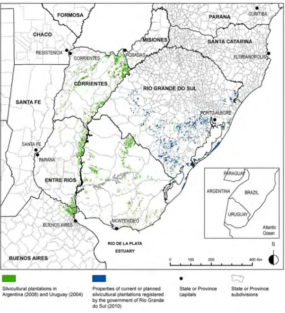
Figure 1. Region sketch and current localisation of silviculture in Rio Grande do Sul (Brazil), Uruguay, Entre-Ríos and Corrientes (Argentina).
Sources: for Argentina, digital files of Inventario Forestal 2008 (Ministerio de Agricultura, Argentina); for
Uruguay, digital file of Mapa Forestal del Uruguay 2004 (Petraglia C. & Dell’Acqua M. 2006); for Rio Grande do Sul, digital layer from FEPAM, representing the limits of the patches already planted with trees or the private properties that are to be partially planted (this layer does not represent the exact area covered by plantations).
In Rio Grande do Sul, the southernmost state of Brazil, an environmental zoning experiment was conducted to control the effects of large-scale industrial plantations of exotic trees on the landscape. These industrial plantations result from agrarian activities that turned the natural temperate grasslands of the Campos area, which covers Eastern Argentina, Uruguay and the southern part of the state of Rio Grande do Sul2, into arable land. This silvicultural expansion (see
and expanded to Eastern Argentina and Rio Grande do Sul, which are today respectively covered by one million, 520.000 and 600.00 hectares of tree farms in 2009.These countries began to compete in order to attract world corporate leaders from the cellulose industry, transforming the Campos region into a new centre of high-productive tree-plantations (Gautreau 2008).
In 2004, the environment administration of the state of Rio Grande do Sul launched a process to define Environmental Zoning for Silviculture Activity (ZAS)3. According to Brazil’s environmental
legislation, each plantation of exotic trees requires a public environmental permit. The zoning plan was thus developed as a tool to guide the licensing process. The silvicultural companies4 initially
encouraged such a document but later intervened to prevent the constraints that it had established on their activities and to revise it. During the ZAS negotiation process, an underlying conflict emerged between environmental technicians of the Rio Grande do Sul administration and a coalition comprised of silvicultural companies and the new public authorities of the State Administration (2007-2010 mandate). The technicians, convinced of the social and environmental risk of large-scale silviculture, launched the ZAS elaboration as a way to manage its effects spatially. The silvicultural coalition considered this elaboration to be an obstacle to regional economic development and largely succeeded in modifying it according to their own interests5.
The ZAS experience offers some insights into the state of Rio Grande do Sul’s creativity in establishing an environmental policy, particularly in comparison with other regions and countries. ZAS can be defined as a response made by a certain sector of society in order to manage the loss of natural grasslands. It is based on a specific knowledge-building process6. It has also encouraged
the emergence of new environmental categories and the diffusion and legitimation of those previously restricted to academic and environmentalist circles, transforming grasslands ecosystems into an explicit conservation target). This constituted an innovation for the region, where grassland formations have not been taken into consideration for conservation purposes during the twentieth century (Overbeck et al. 2007, Gautreau & Hinnewinkel in press). Why did Rio Grande do Sul go so far in its attempt to control silvicultural expansion, compared with neighbouring countries like Uruguay and Argentina that experience the same phenomena but don’t have adopted similar regulation measures?
Two other points make the ZAS example representative of current socio-environmental processes in South America. During the revision of the zoning plan, the silvicultural sector was able to negotiate the final draft of the main document, thanks to its influence over the CONSEMA, a representative body for the environment which is under the control of the Secretary of Environment of the state of Rio Grande do Sul. The CONSEMA relies on the participation of both public and private representatives7. There, stakeholders of the silvicultural sector can have a direct
role in the modification of existing ZAS rules, categories and methods. This situation illustrates increasingly complex company strategies that go beyond political lobbying by directly participating in the environmental knowledge production process. It also highlights the recurring use of new spatial representations of the environment during the ZAS process. More specifically, digital vegetation cover data and physical environment maps (e.g. watersheds, landscape units, etc.) created by scientists from public institutions and stored in free-access institutional databases8,
which were employed during several stages of the negotiation process using Geographical Information System tools9.
Open environmental data are powerful vectors in the rising social sharing of spatial representations of territories and environment (Debarbieux 2003). The information conveyed by these tools is commonly conceived as a factor of the democratisation of information and empowerment that strengthen citizen participation in the regulation of environmental degradation (Waterton & Wynne 2004, Lavoux 2003). Open environmental data may nevertheless reinforce asymmetries between actors in processes of environmental controversies and knowledge production, due to unequal
capacities to deal with and manipulate this kind of data (Crampton 2009). In the ZAS case, our hypothesis is that the silvicultural companies took a slight advantage thanks to the nature of the open data used to produce the final document, minimising constraints on their activity in certain areas of the state of Rio Grande do Sul that were part of their investment plan. Our aim here is to discuss the impact of spatial technologies applied by different sets of actors in environmental controversies, focusing on the ways in which they constrain the collection, production and interpretation of environmental data. As Elwood (2009, p257) notes, “spatial technologies are many things simultaneously […] They are digital systems for storing and representing spatial information; they are complex arrays of social and political practices; and they are ways of knowing and making knowledge”.
A chronology of scientific and technical controversies during ZAS elaboration
Elaboration of the ZAS’ original proposition
In 2004, with the agreement and financial support from various companies, the FEPAM administration decided to adopt a zoning plan for silvicultural expansion in the state of Rio Grande do Sul10,. This zoning plan was considered as a tool to guide the environmental licensing of silviculture in the state (see appendix 1). It was an original attempt to regulate environmental transformations in the grassland region of Campos, which was substantially modified by advancement of the agricultural frontier in the 1990s. The Campos region is a subunit of the temperate grasslands of Río de la Plata (Soriano et al. 1992) characterised by a grassy and shrubby matrix with marginal forests. These grasslands create transitional hilly landscapes between the southern pampa plains and the northern subtropical forests of Brazil. They cover the entire southern half of the state of Rio Grande do Sul, (steppe and steppic savannah classes, in figure 2). In the 1990s, an agriculturisation process (Barsky & Gelman 2001) began and improved throughout the 2000 to 2010 period, favoured by direct sowing technologies and global market demand for grains and fibres.. Rice crops in valleys and wetlands, soja crops, artificial prairies and silviculture occupy a growing area in the region (Pillar et al. 2009), suppressing large parts of the natural cover of the Campos area and its extensive grazing activities. Among activities led by agribusiness companies, silviculture was the main target of social movement critics, mainly because it received massive public subsidies and export facilities after planting trees and manufacturing paper pulp factories (Alvarado 2008). In Uruguay and the state of Rio Grande do Sul, intense campaigns led by environmental NGOs and some of the scientific community denounced the environmental and social effects of this activity (Gautreau 2008)11, in the basis of
academic investigation which point out the negative ecological effects on soils, water and biodiversity of tree plantations (Céspedes-Payret et al. 2009, Pillar et al. 2006, Jobbágy et al. 2006, ) and associated the wood pulp industry (Altesor et al. 2008).
The development of ZAS as a tool for assessing the ecological vulnerability of Rio Grande do Sul to silviculture illustrates an original knowledge production process. At a regional level, it is the only attempt to set spatial rules for silviculture based on a comprehensive assessment of its potential effects, first on soils, water and biodiversity and second on local economies. Argentina did not take similar measures; the existing tool in Uruguay, the establishment of priority soils for silviculture, was used to lead activity toward less productive parts of the country but without any restrictions based on ecological criteria12. At state level, the ZAS in Brazil includes objectives different from
other zoning plans13. Those developed for a specific agrarian activity, such as sugar cane, are
mainly aptitude maps that locate places with higher growing potential but without restrictive rules. These mappings do not analyse the whole territory, but only places with agriculture potential. Zonings for territorial management purposes at the federal or state level, such as the zoneamento
ecológico-econômico, analyse the global environmental features of territories but usually do not
addressed by the silvicultural sector, which highlights discrepancies with the legal apparatus regarding zoning plans in Brazil14.
Figure 2. Land occupation of Rio Grande do Sul in 2000-2003 (above) and localisation of the main silviculture companies’ regions at the beginning of ZAS process in the 2004-2006 period (below).
Sources: Original Vegetation Remnants of Rio Grande do Sul (MMA 2007a), simplified legend (above); digital
layer from FEPAM, representing the limits of the land already planted with trees or that was to be planted in June 2010 (below).
Legend: Silvicultural companies develop several businesses related to wood production. Each company
represented on the map (Stora Enso excepted) had projects of pulp production in the state of Rio Grande do Sul in 2006: Aracruz was planning to enlarge the capacity of its Porto Alegre unit (Guaíba), and Votorantim was planning to establish a new unit between Mirimm and Dos Patos lagunas (SE). Tanac produces Acacia wood chips for exportation toward Japan. The financial crisis favoured the merging of companies worldwide in the pulp industry. In 2010, Votorantim and Aracruz merged to form FIBRIA (second world producer of bleached pulp). The previous Aracruz plantations and pulp unit of Guaíba was sold to a Chilean corporation, CMPC.
Source: Original proposition process is interpreted from SEMA 2007; counterproposal process from GT-CTPBF
2009.
Note: In the original proposition side of the drawing, only the calculation of A and B sub-indexes is detailed. The first version of the ZAS (herein referred to as the “original proposition”) dates from 2006 and followed the classical steps of spatial scoring, where several criteria are mutually combined and weighed within spatial units. First, the territory of Rio Grande do Sul was divided into natural landscape units (NLUs); then, a vulnerability index was calculated for each unit as a measure of the potential risk to the environment due to the planting of tree farms (figure 3)15. During this
process, the use of spatial data was particularly intense. The definition of NLUs as homogeneous natural regions, defined by criteria that reflected genuine physiognomic and landscape features was not a cause for major controversy16. Their limits were established at a 1:250,000 scale. By the
merging of geomorphological data layers and “original potential vegetation” layer with GIS tools, a new layer combining phytogeographic and geomorphologic features of the landscape was formed. Then, the different units (polygons) of this layer were grouped into larger entities using soil and altitude as criteria to define each NLU. The vulnerability index, which was calculated later, is “an indication of the conflict potential between silvicultural activity and the objectives of natural resources and biodiversity conservation” (SEMA 2007, vol 1, p 41). It was built from five sub-indexes: hydric availability, grasslands conservation/threat degree (see figure 4.A), vulnerability of
endangered fauna species, vulnerability of endangered flora species and touristic attractiveness. Each of these sub-indexes was also built from primary indexes (see appendix 2 for details)17. After
the normalisation of each sub-index on a 0 to 1 range, they were combined following a weighting operation (figure 3, left) to establish three main categories of restriction (figure 4.B).
Figure 4. Results of the ZAS original proposition, compared with the current land acquisitions by silvicultural companies.
Source: (A) and (B) Values from SEMA 2007, incorporated to the attribute table of the landscape unit digital
layer downloaded from the Fepam website on June 2010. (C) Mastrascusa Rodrigues et al. (2001). (D) Digital layer from FEPAM representing the limits of the land already planted with trees or planned to be planted.
Legend: figure 4.D indicates the average plantation rates in 2009 of tree farm properties with an area superior
to 10 fiscal modules (for the largest properties). The value is indicated for every landscape unit where the ZAS original proposition limited this rate to 35% for these properties. The units where this limitation is currently exceeded by silviculturers are indicated in red. The fiscal module is a unit used to classify the properties of the Brazilian municipes according to the average conditions of production and productivity; it varies depending on the municipe. In the mapped landscape units, 10 fiscal modules represent 100 to 800 hectares.
The ZAS coordination team built rules based on this vulnerability index to control silvicultural activity on different spatial scales. At the state level, a ban was put on planting farm trees around protected areas that were not yet clearly delimited or equipped with a management plan18. The
need to avoid a lack of connectivity among remnant natural habitats was stressed, and another ban was put on planting trees on patches of native forests and primary grasslands. At the landscape unit level, the main objective was to detain the matrix inversion without neglecting the balance between native vegetation physiognomies and converted ones (crops, urban areas, tree plantations, water reservoirs, etc.). Thus, for each landscape unit, a specific range of restrictions on tree plantations was established: From 25% to 50% of each property area could be planted with
tree farms; the bigger the property size, the lower the percentage allowed for plantations. Additionally, some landscape units were completely excluded from new plantations, and exclusion buffers were defined around rocky outcrops, wetlands, paleontological and anthropological sites. Considering these criteria, it was initially possible to evaluate and issue environmental permits for each project of exotic tree plantations, ensuring a balance between conservation objectives and economic development.
This set of rules largely contradicted the companies’ expansion projects, which were prepared before the first ZAS release at the end of 2006 (figure 4). The lands that they were planning to buy or had already bought (and even planted) were almost entirely located in landscape units with medium or high restriction on silviculture. The restriction to tree farm size based on the property area was particularly criticised by companies, because they planned to plant a higher percentage of their properties than the allowed percentage by the ZAS. Figure 4.D shows that in a large part of the State, the allowed percentage to be planted was 35% of each property, when companies used to plant until 60% of theses properties.. Thus, the original proposition encountered huge opposition from the corporative sector19 and, consequently, from government representatives in CONSEMA.
Counterproposals to ZAS: Intermediate and final versions
The first proposition was modified after two main events. A few months after the release, two CONSEMA chambers, Câmara Técnica de Biodiversidade e Políticas Florestais (CTPBF) and Câmara para Assuntos Jurídicos (CTPAJ), introduced major modifications that weakened the initial set of rules. Those were adopted on April 9, 2008 after a CONSEMA voting session challenged by several members20. This intermediate version led to a six–month period of reduced restrictions on silvicultural projects. Several environmentalist NGOs and institution members denounced the new rules as completely inefficient for ensuring environmental integrity during this period of silvicultural expansion21. They took public civil action22 conducted by the Ministério Público of the state of Rio
Grande do Sul23 and won a court decision. As a result, the intermediate version had to be
reformulated, since it did not take into account important technical remarks made by the Fundação Zoobotânica do Rio Grande do Sul (FZB), a research and conservation state institution and one of CONSEMA’s members. In April 2008, the FZB criticised the withdrawal of any strict criteria to curb silviculture in the intermediate version and the implicit subjectivity of the new generic rules during the licensing process (FZB 2008). In addition, FZB proposed to include a set of specific criteria concerning the maximum of silvicultural areas allowed within each NPU as well as the maximum size of tree farms allowed and the minimum distance between them as additional spatial rules in ZAS.
In order to avoid time-consuming judicial processes, the silvicultural sector created a new strategy, shifting focus from the influence on state authorities to technical negotiations for an alternative intermediate version24. This new attempt tried to combine environmentalist expectations for
limiting the fragmentation of grasslands with corporative interests to minimise production costs, allowing the companies to maximise the size of tree farms and to minimise the distance between them. The silvicultural sector published two documents which contained methods and criteria (FIERGS at al. 2009a & 2009b)25 as a first approach to the new zoning plan. They were discussed
with the environmentalist NGOs in a committee for technical negotiations composed of the CONSEMA working group (GT-CTPBF) in charge of the last proposed draft version26.
Due to this high level of political conflict, the technical staff of FEPAM and FZB were prevented from participating in the negotiation and revision of the final draft version, weakening the capacities of NGOs to contest or formulate new technical methodologies. At this stage, even with a judicial decision in their favour, the environmentalists were part of a very unbalanced scenario. Their ability to negotiate decreased, when the majority of CONSEMA members were still likely to vote for
a new zoning proposal that favoured the silvicultural sector. Surprisingly, a final consensus led the final draft version to be approved by CONSEMA on May 5, 2010, reducing the size of the potential area to be planted with trees from 8 to 3.5 million hectares27. In the intermediate and final
versions, the silvicultural sector clearly influenced the majority of voters in CONSEMA and showed a high technical capacity to propose alternative methods for elaborating ZAS criteria within the framework set by the justice authorities. In the following sections, we detail the methods and criteria established in the intermediate and final versions of ZAS.
Building criteria for the intermediate and final versions
The ZAS evolved from its original proposal based on a single spatial unit (the natural landscape unit) characterised by five criteria and complex qualitative and collective assessment carried out by experts, with limitations for new plantations set at the property level (table 1). In the final version, the rules referred to a mixed spatial unit (watersheds divided by landscape unit) and concerned the maximum percentage of this spatial unit allowed to be planted with tree farms, the maximum tree plantation size and the minimum distance between tree plantations. The maximum percentages, maximum sizes and minimum distances were specific to each spatial context and based on a ranking of criteria that included the water availability of each watershed and the vulnerability of each landscape unit.
The critics addressed by CONSEMA chambers led to a more lenient second version (CTPBF 2008 & CTPAJ 2008). The objective was to transform the ZAS, considered as an overly restrictive set of directives, into a land planning document that would boost silviculture activity rather than constrain it28. In its comment to the original proposition, the CTPBF deepened this dimension of the critiques. Its purpose was to include in the objectives of ZAS the “[promotion of]jobs and [creation of] new sources of income in the regions of silvicultural expansion, as well as [improvement of] the standard of living of the local population” (CTPBF 2008). This was coincident with the companies discourse, which affirm that silviculture systematically favours rural development. The two CONSEMA chambers pointed out the lack of socio-economic variables in the aforementioned proposition. They worked to transform the ZAS plan into a document that would promote this “activity’s insertion in the state territory” instead of restricting its expansion, defining the landscape unit as a planning unit rather than an ecological one. The major modification was the complete removal of restrictions limiting the size of tree farms depending on the size of the property area29.
The new text appointed a working group (GT) coordinated by the license issuing office (FEPAM) to define the “occupation and distribution parameters” of watersheds and landscape units in order to ensure an ecological conservation and avoid the formation of extensive and continuous tree plantations. In other words, the changes proposed by the two chambers led to more flexible criteria, giving way to silvicultural projects, but simultaneously made their control more vague and complex (table 1)30.
In the counterproposal of the pro-silviculture groups (FIERGS at al. 2009a & 2009b), the authors claimed that the original proposition lacked scientificity and objectivity and thus proposed what they considered as objective methods to establish limits on silvicultural activity. The first document (FIERGS et al. 2009a) defined maximum percentages of occupation by watersheds, making water availability the only ruling criterion. The methodology followed four steps: for each of the climatic regions defined within Rio Grande do Sul’s frontiers, an index was established to evaluate the reduction of water flow when grassland vegetation is replaced by tree plantations (figure 3, right). The index was recalculated for each watershed, calculating the sum of the watershed values obtained from all climatic regions in accordance with the proportional area occupied by watershed. The third step was to calculate, for each watershed, the relation between tree farm extension and the estimated water flow reduction. Thus, with respect to the third step, the fourth step calculated the sum of the maximum percentages of occupation by watershed: they were calculated
proportionally with the average annual hydrologic balance (the values ranged from 30% of the watershed area, where the balance was highly positive, to 6%, where it was low positive31). These
percentages were reduced in the watersheds that presented very low balances during the summer months (December to March).
Table 1. Evolutions of the ZAS versions: spatial units and main criteria.
Versions Date Authors Spatial unit Main criteria Documents
Original January 2007
SEMA, FEPAM and FZB
NLU - Natural Landscape Unit
- Vulnerability index of the NLU to silvicultural activity.
- Limitation of the tree farm size
proportional to property size (variable
according to the vulnerability index and farm class sizes). SEMA 2007 April to October, 2008 Câmara Técnica de Biodiversidade e Políticas Florestais of CONSEMA Watersheds
- Elimination of the limitation rules according to the property size.
- No quantitative criteria. CTPBF 2008 Interme- diate October 2008 to May 2010 Fundação Zoobotânica do Rio Grande do Sul NLU
- Maximum percentage of silviculture in each NLU.
- Maximum size of each tree farm. - Minimum distance between tree farms.
FZB 2008
Last May 2010 Working group of CONSEMA
Watersheds divided by NLUs
- Maximum percentage of silviculture in each unit “watershed divided by NLU”.
- Maximum size of each tree farm. - Minimum distance between tree farms.
GT-CTPBF (2009), SEMA (2010)
The second document (FIERGS et al. 2009b) defined a maximum size for the tree farms and established a minimum distance between them for each landscape unit. It offered a new way to calculate the values proposed by the FZB in 2008, which did not include enough elements to establish a replicable method for calculation that would enable a periodic actualisation of data. The FIERGS et al. group criticised the fact that in the FZB‘s proposition, there was no “perfect linear relation” between the vulnerability index by landscape unit and the maximum size and the minimum distance values. This position clearly reflects a refusal to accept the value of qualitative assessments, such as those led by the FEPAM and FZB teams32. The applied method followed four
main steps. First, using GIS analysis of digital land-use maps of Rio Grande do Sul (MMA 2007), the authors calculated the relative area of different types of land use to each landscape unit. Next, they defined the types of land use with at least 80% of the landscape unit as the matrix. Then, the average size of the largest 10% of patches was taken as the reference value for the tree farms area. Finally, this value was reduced with respect to four parameters: size of the landscape unit, fauna fragility index, campos fragility index, and conservation targets specific to each unit33. The
authors took the radius of a circle equivalent to the permitted maximum tree farm area in each landscape unit as a reference in order to calculate the minimum distance between tree farms. This value (i.e. the radius) was then reduced by 64% (radius x 0.56). The goal of this last operation was to take into account the porosity of current tree plantations in the Rio Grande do Sul, formed from tree blocks separated by buffers, rocky outcrops or legally protected areas34.
The establishment of a maximum size of tree plantations and a minimum distance between inspired by conservation biology research. To set such criteria is as a strategy to prevent the loss of structural connectivity of the grassland matrix) and to reduce the risk of isolation of flora and fauna communities. The replicable method to establish these values proposed by pro-silviculture groups remained in use despite the lack of a scientifically established relationship between the proposed values and the the functional connectivity of grassland remnants. Ultimately, the methodology used by the FIERGS et al. group was adopted by the CONSEMA working group (GT-CTPBF) and served as a basis for the final version of the ZAS accepted in May 2010. Their results were slightly modified with the negotiation of more restrictive values based on the vulnerability and biodiversity concerns of each NLU, and the definition of a new spatial unit, formed by the subdivision of
watersheds by landscape units (the “NLU x Watershed” unit, GT-CTPBF 2009). The use of watershed as a unique spatial reference was considered insufficient by environmentalist groups, because it did not take into account the ecological heterogeneity of space.
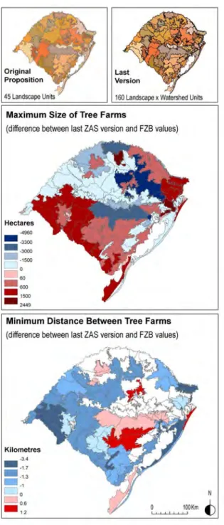
Figure 5. Changes between the Fundação Zoobotânica Values (FZB) from 2008, and the last version of ZAS in 2010.
Source : FZB 2008, SEMA 2010.
The final version is clearly a compromise: it includes strict criteria to be defined and grassland conservation measures to be taken; however, it also includes rules favourable to silvicultural expansion. Compared to the former FZB proposal (FZB 2008), the maximum area of tree farms is increased, and the minimum distance between them is reduced in the Southern half and in the Northeastern corner of the state, the areas chosen by companies to extend their business (figure 5).
The role of environmental conflict in legitimating new environmental categories
At a state level, the ZAS process was the first measure in a region that officially gave environmental status to the natural grasslands. For the first time, an official document defined these particular temperate grassland formations for the purpose of conservation. It put an end to the following paradox: the dominant vegetation of the Campos region remains marginally included in the conservation programs of Uruguay, Eastern Argentina and the state of Rio Grande do Sul, while forests and wetlands are at the core of the states’ conservation efforts. For this reason, Overbeck et al. (2007) referred to the Campos biome as “neglected” by Brazilian conservation policy. In ZAS, Campos are defined as a continuum of low-sized vegetation forms, inserted in several open vegetation landscapes with variable proportions of trees, from savannah to wooded steppe. Thus, the ZAS constituted an important stage in the current efforts to provide ecological status to the Campos by the end of the 1990s (Gautreau & Hinnewinkel in press). The reason why this stage was initially achieved in the Brazilian part of this region rather than in the Argentinean or Uruguayan parts will now be analysed further. However, it is important to first examine the decisive contribution of the ZAS process to the legitimation of grasslands as a type of vegetation that deserves to be conserved.
In order to establish criteria for managing the silvicultural process, the original ZAS proposition defines the grasslands at several levels. At the landscape unit level, the calculation of a grassland conservation index (appendix 2) was based on the description of macro features like open habitat fragmentation and loss. At the local level, the document floristically, biogeographically and dynamically defines what must be considered as grasslands. Appendix 1 of the original proposition states that grasslands include all vegetal communities with herbaceous and/or shrubby structure, in any regeneration stage, with its soil, flora and fauna, interactions, resources and values linked to it. It comprises all physiognomies of Savannah and steppe associated to the Pampa and Mata Atlântica biomes (SEMA 2007, Vol.1). Four successive stages were identified (primary, advanced, medium, and early regeneration stages), ranked in accordance with a decrease in species’ richness and abundance, a rise in anthropic perturbations and abundance of alien plants35. In order to serve
as an effective tool for silvicultural control, the authors updated the official Brazilian definition of primary vegetation commonly used for forests as the vegetation with maximum local expression. In regards to grasslands, they stressed that “primary vegetation of grasslands […] is not necessarily linked with high biodiversity” due to the local biophysical features (SEMA 2007, Appendix 2).
The originality of the first ZAS draft lies in its effort to define and legitimise the category of grasslands in several complementary ways and to address some of the actors playing a part in the environmental change in Brazil. The importance given to the grassland sub-index in the calculation of the vulnerability index of landscape units highlights this vegetation as the primary target of the ZAS policy. The ZAS definition and legitimisation of grasslands could be interpreted as directed to Brazilian actors at the federal level, in order to show that it is essential to protect grasslands by classifying them as an endangered natural entity.
The ZAS definition also presents some contradictions in key aspects of the silvicultural sector’s discourses. Companies generally argue that they plant trees on “deteriorated” grasslands in order to minimise the ecological impact of their activity. This argument is commonly used in environmental impact studies led in the region to justify silvicultural expansion36 and was used in
the companies’ counterproposal to the ZAS: “In spite of the fact that the number of native species is lower in tree plantations when compared to natural forest, plantations are increasingly substituting ecosystems modified by humans (for example, degraded grasslands)…” (FIERGS et al. 2009b). A four-fold categorisation of the regeneration stages of grasslands indicates that degradation is a temporary stage that can be reverted and that species poverty does not mean
that vegetation has been deteriorated. Both elements show that the effort to define the ZAS directly confronts these biased and scientifically unfounded arguments.
The ZAS process clearly demonstrates the role of environmental conflicts in legitimising new environmental categories and diffusing them to society. The process established common use of the “grasslands” term in environmental politics. While the CTPBF document (2008) limited the ability to curb tree plantation in the main part of the state37, it reduced the aforementioned
regeneration stages of grasslands to three types: “preserved or lowly anthropised, moderately anthropised and highly anthropised grasslands”38. According to the CTPBF, the grasslands to be
planted were to be identified by an expert at the local level of every farm. Additionally, the grassland types for Rio Grande do Sul were to be defined by a working group. This reveals a consensus on the legitimacy of actions that tend to identify grassland types in Southern Brazil, in the same way as types of forests are identified in other parts of the country.
Compared to Uruguay and Argentina, where no such measures have been taken, Rio Grande do Sul can be considered a pioneer in establishing original forms of control of agricultural intensification. The main constraints that delayed the ecological valorisation of Campos, as identified by Gautreau & Hinnewinkel (in press), have been partly resolved. These constraints are primarily linked to the difficulties to scientifically define the nature and genesis of Campos, because they form a biogeographical margin, composed by transitional landscapes between Argentinean pampas and subtropical forests of Southern Brazil. The lack of a robust theory about its genesis until the end of the 1990s, and the absence of fine-scale mapping of subunits, made it difficult to underline the real ecological importance of these grasslands. It is in Rio Grande do Sul that their historical genesis received the most attention from scientists. Studies by Behling et al. (2005, 2004) and Roth and Lorscheiter (1990) confirmed that grasslands were formations inherited from past drier periods39. In Uruguay and Argentina, the inherited origin of grasslands is hidden in public debates, where the false belief that a great part of them were formed by forest deterioration (Gautreau 2006)40
remains dominant. The ZAS process was made possible thanks to the diffusion of scientific findings that grasslands are an inherited natural formation. Recent local workshops and colloquiums helped with the larger diffusion of such ideas (Pillar et al. 2006, 2009). The spreading of this ecological knowledge to the state and federal levels of the administration also explains why technical evaluations have been developed to identify comprehensive priority areas for a conservation system explicitly protecting the Pampa biome (MMA 2007b). An equivalent process does not exist in the other countries sharing the Campos biome.
Moreover, Rio Grande do Sul is the only state of the Campos region that has mapped its vegetation on an adapted scale that allows for spatially differentiated conservation politics like the ZAS. Neither Uruguay nor Argentina has developed the same 1:50,000 official cartography of land and vegetation cover (MMA 2007a)41. This document updated on a finer scale the mapping of
vegetation led in the 1980s by the Radambrasil project (IBGE 1986). Droulers and Letourneau (2000) highlight the impact of cartography on the rise of environmental control of deforestation in Amazonia. For the Campos region, it is obvious that the diffusion of the medium scale map of this vegetation (MMA2007a) is a powerful vector for ecological valorisation. The fact that both FEPAM and FZB as well as companies used this map during the ZAS process illustrates the importance of mapping activities to support conservation policy-making.
Within Brazil, Rio Grande do Sul is known as one of the states where ecological activism and conscientiousness were prominent and historically precocious due to the higher level of education and the importance of the middle classes (Crespo 1993). Compared to its neighbours, Brazil has a far more institutionalised environmental policy: the existence of state environmental councils (CONSEMA for Rio Grande do Sul) and specialised judges within the Ministério Público ensured an in-depth debate on how to regulate silviculture. This social and political context explained largely
why such an environmental regulation project as ZAS was undertaken. It allowed the first authors of ZAS to build a tool adapted to new dynamics of agriculture in the Campos region, aming making this experience replicable to similar activities coping with Rio Grande do Sul’s natural vegetation.
Consequences from the intense use of digital environmental representations: Elements for controversy
The ZAS is closely linked to an intense use of digitalised geographical data on vegetation by all participants in the process. Calculations and controversies were based on the use of GIS layers, mainly the vegetation map of Rio Grande do Sul, which is available for free on the Environment Ministry website (MMA et al. 2007). These layers constitute spatial or localised data, formed by geometrical objects representing some features of space in two dimensions: For example, at a 1:100,000 scale, rivers and roads are represented by lines; cities, by dots; vegetation, by polygons. These geometrical objects are linked to an attribute table that describes their semantic content (for example, name, area and city status are marked with a dot). GIS layers can be defined as new representations of space in general and environment in particular, because they can be modified by users. Contrary to paper maps, the user can interact with this data, modify both its form and its semantic content, and create new information by crossing it with other spatial data.
The facility to manage this kind of data in Geographical Information System software, and the diffusion of GIS tools, explains why GIS layers are every day more used in environmental controversies. However, this easily manageable data can make the user forget the implicit scientific theories as well as the fact that digital maps, like all maps, are created within a particular scientific paradigm or frame. The diffusion of digital maps allows persons who are not entirely prepared to analyse the scientific construction of those maps to use them. This provokes a lack of criticism towards such data, leading to social constraints: few people are prepared to detect the voluntary or involuntary misuses of digitalised maps. The ZAS process is highly representative of the importance that these kinds of representations have acquired in current environmental controversies. All actors involved in the process used this kind of data, but some showed greater abilities to defend their positions using this data. The diffusion of public digital data on the environment, which is generally stressed as a factor of democracy and empowerment (Alves dos Santos Júnior 2003)42, does not systematically reduce the existing asymmetries between power
holders, as social competence to read and elaborate territorial and environmental spatial representations are unequally distributed in society (Debarbieux 2003). In the ZAS case, our hypothesis is that the use of this data enabled silvicultural companies to reinforce their positions. In fact, the ZAS case is representative of the bias that the use of digital geographical data creates in environmental debates, linked to the contemporary massive use of spatial representations in public controversies on territorial management (Lardon et al. 2001). All the actors of the ZAS process used the digital map of Rio Grande do Sul’s vegetation (MMA 2007a) in several stages of their action. One of the aims of this core document was to map the original vegetation remnants of Southern Campos. This goal was undertaken by the Center of Ecology of the Federal University of Rio Grande do Sul. FEPAM and FZB members used this map to calculate open habitat loss and open habitat fragmentation, two values used for the grassland conservation sub-index (figure 3 and appendix 2). Open habitat loss was calculated by comparing the map with previous data (Radambrasil map of 1986)43. Open habitat fragmentation was established by calculating the
average size of open habitat polygons on this map. However, the northern part of the state, part of the Mata Atlântica Biome (figure 2), was not represented on the original vegetation remnants map. Based on statistical data at a municipal level44, habitat loss was estimated, and habitat
fragmentation was extrapolated from other open habitat zones. The original proposition document offers few elements to estimate the bias that might have been caused by a method that tended to
fill existing data gaps; the final values of the grassland conservation sub-index for the entire state of Rio Grande do Sul were then established resorting to heterogeneous data. On the other side of the conflict, FIERGS et al. members also made intensive use of the digital original vegetation remnants map in order to propose their way to calculate the maximum size of tree farms (figure 6).
Figure 6. Digital data analysis for the calculation of a maximum area of tree farms by landscape unit: example of the DP2 unit.
Source: Original Vegetation Remnants of Southern Campos map (MMA 2007a); FIERGS et al. 2009b.
In both cases, the opponents did not appear to discuss the technical limits that such a digital document offered to their analysis45. This map was created based on Landsat satellite images.
These images were acquired mainly in 2002, but the acquisition date ranged from 1999 to 200346.
At first, this created internal data heterogeneity, with temporal differences reaching as many as four years between the taking of some images. The final map was released in 2007, what means that some of its parts were based on seven-years old data. In the context of fast landscape changes experienced in the state of Rio Grande do Sul and the Campos region, the use of outdated reference documents may cause important bias and misinterpretations. The second decisive bias was linked to the resolution of satellite data and the way in which it was interpreted by the authors of the map. The Landsat satellite delivered 30 m x 30 m square pixel images with a medium resolution size. These images were visually interpreted by digitalisation at a 1:50,000 scale on the computer screen. This scale choice resulted from arbitration between the time-consuming effort to map a nearly 180,000 km2 territory and the need to maximise the accuracy of the map. The finer the digitalisation scale on the screen, the more time needed for the interpreter to create the polygons of the map. For this reason, the authors thus dismissed the possibility to map vegetation at a finer scale of 1:25,000.
The question of scale was an important issue in the ZAS process. During the calculation procedure to establish the maximum size of tree planting areas by silvicultural companies, the average size of matrix patches used as a basic value automatically increased due to the map scale (figure 7). Any finer scale of vegetation mapping would have reduced the average size and the maximum size of the tree farm value. The digitalisation of Landsat images at a 1:50,000 scale on screen automatically eliminated several fragmentation elements of the landscape. Roads and rivers inferior to a given size disappeared or became blurry on the image47. In other words, they were not
taken into account by the interpreter48. From this perspective, the under-evaluation of
fragmentation due to scale favoured the companies’ attempts to increase the maximum size of tree farms in those areas that were part of their own development projects. This supports the hypothesis that the diffusion of open public environmental digital data may reinforce the asymmetry between the actors. When not questioned in social controversy, the technical constraints of the data, in this case, due to scale, allow misuses or bias to some of the actors’ advantage. This leads to the question of why map scale was not questioned during the debate. The hypothesis in this paper is that the ease with which digital data can be diffused and modified stimulates the neglect of criticism on the interpretation constraints: the complexity of the data modification process incites the participating operators to hide procedure traceability. In the ZAS case, an underlying consensus on the reliability of the original vegetation remnant map was reached when no actor was reluctant to allow the others to use it. In this case, this consensus played a favourable role in the companies’ counterproposal methods. Then, even if a company’s sector had to accept the criteria proposed by their opponents, that means the conservation of Campos by limitation of their fragmentation, the proposed method and the tools to calculate the aforementioned criteria created a bias favoring the silviculture sector.
Another key issue is linked to the use of digital vegetation maps in current environmental zoning processes. The ZAS is not an isolated example in the region, where such data are increasingly used in participative mapping processes49. This new kind of data includes scientific notions and
paradigms which serve to build the map categories. On the original vegetation remnants map, the basic paradigm is the existence of two clearly distinguishable categories of vegetation: the original and the anthropised. This paradigm was not questioned by the participating actors in the ZAS process, even if it is highly questionable from a scientific perspective50. Another question lies in the
way anthropised campos were identified, mainly by localisation of “the existence of intensive agriculture signs”, like drains or soil lines observable in Landsat and Quickbird remote sensor imagery (Cordeiro & Hasenack 2009). This may have led to an underestimation of anthropic modifications, for example, through the use of chemical herbicides. The main point we would like to underline is the consensus between the opponent. None questioned the bias linked to the methodology used, even though their important consequences in terms of regional zoning for the silviculture. It is likely that these biases were tacitly accepted, even though a lot was at stake. Figure 7. Effects of digitalisation scale on the sub-evaluation of open habitats fragmentation in the map “Original Vegetation Remnants of Southern Campos” (MMA 2007a).
Legend: the figure shows how the choice to digitalise Landsat images at a 1:50.000 scale led the authors of the
original vegetation remnants map to generalise the form of the landscape patches. The comparison with an automatic classification of the same kind of image shows that small patches were incorporated into larger ones (small forest galleries in the centre of the image were incorporated in the grassland patches). For the same reason, important elements of fragmentation like roads or rivers are not incorporated in the original vegetation remnants.
Increasing participation of companies in the knowledge production
The ZAS process sheds light on recent changes in how corporations participate in environmental debates in the region. Their intense participation in the process (Ormazabal 2009) since 2004, during which they came up with a counterproposal, goes far beyond the mere action of lobbying; it can be considered a part of the process of knowledge elaboration, as they participated in the legitimating of partially established categories (such as grasslands) and succeeded in imposing new ones (such as “watersheds). The companies achieved some success in proposing new methodologies to calculate regulation criteria and in producing data by managing digital geographic
information. Beyond their evident economical interest inciting this behaviour, some questions remain, namely, why their participation in environmental knowledge constitution is much more intensive in Rio Grande do Sul than in Uruguay and Argentina, neighbouring countries dealing with equal problems of silvicultural expansion taking over grasslands.
What are the specificities tied to their way of influencing the process of knowledge production during ZAS elaboration? First, the national origins of the companies might have played an important role. In Uruguay and Argentina, the main silvicultural corporations had foreign origins51
and were mainly Brazilian during the ZAS revision process52. The Aracruz company was particularly
exposed to social dissent due to the trials it faced in the state of Espirito Santo from indigenous and peasant groups53 and to the localisation of several tree farms and its cellulose factory near
Porto Alegre city, which exposed it to forms of urban population dissent. The Votorantim company concentrated its activities’ expansion in the far southern part of the state, more precisely in a region with important rural settlements of the Brazil Landless Workers’ Movement (MST) which militated against tree farms on the entire Brazilian territory. In both cases, we hypothesise that both companies had important interests in showing their participation in the ZAS process in order to reduce their exposure in the social dissent at the local and national level. The ability of the companies to highly influence the process of knowledge production is another feature of the ZAS case. The companies first chose a strategy of zero negotiation and partially succeeded by drastically eliminating the constraining rules in the original ZAS version. Facing a legal defeat, they shifted to a new strategy based on direct technical negotiation without denying the conservation biology framework (the need for rules of maximum percentages of occupation, maximum size and minimum distances between tree patches).
However, they presented methods and procedures committed to achieving their productivity goals. The existence of free public digital data was decisive for the support of this strategy. Using the original vegetation remnant map as the core document for calculating new regulation criteria the companies re-enforced their legitimacy for participating in the debate: who could doubt the quality of a document produced at a federal university known for the quality of its researchers and, by extension, the quality of the results of the analysis upon which it was based? The ability of the companies to influence the process relied on several aspects. The scientific training of their internal experts on environment allowed them to deal with spatial data and with natural science concepts derived from landscape ecology54. They also showed an ability to develop innovative uses of this
data which consisted of placing the digital map in the centre of the discussion about ZAS (including environmental NGOs), while proposing a new way of considering this map in the calculation of regulation criteria
Conclusion
The ZAS case addresses the issue of the social traceability of contemporary methods for environmental territorial planning. The attempts to grasp the complexity of the environment through spatial scoring methods, often accompanied by production of spatial data and analysis, led to the emergence of management categories which were hardly decipherable by potential non-expert users. It may be impossible to reconstitute the path that led to the establishment of a threshold between categories without an in-depth and technical capacity allowing a deep analysis of the created documents. This may weaken the ability of citizens to understand the scope of those plans in simple terms. The complexity of the methods adopted explains why the ZAS conflict remains a classical environmental conflict where experts play a central part. When it comes to other Brazilian cases or to the Argentinean case, for example, the direct participation of citizens was marginal during the document elaboration. The ZAS conflict was not unique, as powerful companies in alliance with state government were able to weaken the original restrictive version, nor was its creativity due to the well-known presence of an important pro-environmental regulation
movement composed of civil servants, NGOs and researchers in Southern Brazil. Compared with its South American neighbours, Brazil shows strong institutionality of its environmental administration. Its characteristic features lie in several aspects. The first authors of the ZAS plan evaluated the global vulnerability of the environment by assessing only one agrarian activity on a large territory. The ZAS represents an infrequent response from environmental institutions to the recent rapid progression of non-Amazonian agricultural frontiers from the 1990s, a contemporary process comparable to the Argentinean attempts to conserve forests from soy expansion (Native Forest law, 2007). Moreover, the ZAS is representative of the processes that led to the legitimating of the neglected ecosystems conservation: compared with agriculture, silviculture is neither the single nor the main threat to grassland conservation. However, the conflict that was roused by this activity had an unexpected consequence, that is, the affirmation of its ecological importance and social recognition as a central piece of Rio Grande’s environment. At the very least, the ZAS conflict brings to light the need to analyse in detail the emergent forms of building knowledge (in our case, a management plan) linked to the diffusion of digital environmental representations (in this case, a vegetation map). This data and its widespread use by all actors of the process unpredictably modifies the way environmental controversies evolve, allowing new forms of justification or the establishment of regulation categories and methods. During the ZAS controversy, the intensive use of this type of data had an impact on the relations between opponents. Pro-silviculture actors were surprised by the way in which the pro-regulation sector made use of the vegetation map in order to calculate open habitat loss and fragmentation. This allowed grasslands to be considered as a key element in the restriction calculation. On the contrary, companies succeeded in imposing a new way to calculate restrictions upon silviculture using the landscape analysis based on the same map. This use has been largely favourable to them. Spatial data not only entails dangers of bias in analysis during environmental conflicts but may also create decisive bifurcations in their development.
Bibliography
Altesor A., Eguren G., Mazzeo N., Panario D. and Rodríguez C., 2008, “La industria de la celulosa y sus efectos: certezas e incertidumbres”, Ecología Austral, 18, 291–303.
Alvarado R., 2007, « Política forestal, plantas de celulosa y debate ambiental. Uruguay tras un nuevo modelo de desarrollo », in Palermo V. & Reboratti, C. (dir.), Del otro lado del Río.
Ambientalismo y política entre uruguayos y argentinos, Edhasa, Buenos-Aires, 57-92.
Alves dos Santos Júnior O., 2003, “Democracia e Cidadania”, in Alves dos Santos Júnior et al (Org.)
Políticas Públicas e Gestão Local, Programa Interdisciplinar de Capacitação de Conselheiros
Municipais, Rio de janeiro, FASE: 31-37.
Barsky O. & Gelman J., 2001, Historia del agro argentino. Desde la Conquista hasta fines del siglo
XX, Buenos Aires, Grijalbo-Mondadori, 460 p
Behling H., De Patta Pillar L., Girardi Bauermann S., 2005, “Late Quaternary grassland (Campos), gallery forest, fire and climate dynamics, studied by pollen, charcoal and multivariate analysis of the São Francisco de Assis core in western Rio Grande do Sul (southern Brazil)”, Review of
Palaeobotany and Palynology, N°133, 235– 248.
Behling H., De Patta Pillar V., Orlóci, Girardi Bauermann S., 2004, “Late Quaternary Araucaria forest, grassland (Campos), fire and climate dynamics, studied by high-resolution pollen, charcoal and multivariate analysis of the Cambara do Sul core in southern Brazil”, Palaeogeography,
Palaeoclimatology, Palaeoecology, N°203, 277-297.
Benatti, J.H., 2003, “Aspectos legais e institucionais do zoneamento ecolôgico-econômico”, Revista
de Direito Ambiental, São Paulo, N°29, 103-114.
Céspedes-Payret C., Piñeiro G., Achkar M., Gutiérrez O., Panario D., 2009, “The irruption of new agro-industrial technologies in Uruguay and their environmental impacts on soil, water supply and biodiversity: a review”, Int. J. Environment and Health, 3, N°2, 175–197.