HAL Id: hal-03014565
https://hal.archives-ouvertes.fr/hal-03014565
Submitted on 19 Nov 2020HAL is a multi-disciplinary open access archive for the deposit and dissemination of sci-entific research documents, whether they are pub-lished or not. The documents may come from teaching and research institutions in France or abroad, or from public or private research centers.
L’archive ouverte pluridisciplinaire HAL, est destinée au dépôt et à la diffusion de documents scientifiques de niveau recherche, publiés ou non, émanant des établissements d’enseignement et de recherche français ou étrangers, des laboratoires publics ou privés.
New insights into the recent eruptive history of
Montagne Pelée (Lesser Antilles Arc) from offshore
marine drilling site U1401A (IODP Expedition 340)
Clara Solaro, Georges Boudon, Anne Le Friant, Hélène Balcone-Boissard,
Laurent Emmanuel, Martine Paterne
To cite this version:
Clara Solaro, Georges Boudon, Anne Le Friant, Hélène Balcone-Boissard, Laurent Emmanuel, et al.. New insights into the recent eruptive history of Montagne Pelée (Lesser Antilles Arc) from offshore marine drilling site U1401A (IODP Expedition 340). Journal of Volcanology and Geothermal Research, Elsevier, 2020, 403, pp.107001. �10.1016/j.jvolgeores.2020.107001�. �hal-03014565�
1
New insights into the recent eruptive history of Montagne Pelée
1(Lesser Antilles arc) from offshore marine drilling site U1401A (340
2Expedition IODP)
34
Clara Solaro a, Georges Boudon a, Anne Le Friant a, Hélène Balcone-Boissard b,
5
Laurent Emmanuel b, Martine Paterne c, and IODP Expedition Science Party
6 7 8 a Université de Paris, Institut de physique du globe de Paris, CNRS, F-75005 Paris, France. 9 b Sorbonne Université, Institut des Sciences de la Terre de Paris (ISTeP), UMR 7193, 4 place 10 Jussieu, 75005 Paris, France. 11
c LSCE, - UMR 8212 - CEA-CNRS UVSQ/IPSL, Avenue de la Terrasse, Domaine du CNRS, 12 91198 Gif Sur Yvette Cedex - France 13 14 15 16 17 Key words : Montagne Pelée, Tephrochronology, eruptive history, flank-collapse, IODP 18 expedition 340 19 20 21
Corresponding author: Georges Boudon (boudon@ipgp.fr) 22
Université de Paris, Institut de physique du globe de Paris, CNRS, F-75005 Paris, France. 23
Tel: 00 33 1 83 95 76 32 24
2
ABSTRACT
25 26
Marine tephrochronology provides a good alternative to study in depth the eruptive history of 27
volcanic islands in a tropical climate and overcome the problem of poorly preserved 28
outcropping. Here, we provide new observations on the recent volcanological evolution (< 40 29
kyrs) of Montagne Pelée (Martinique Lesser Antilles) based on the tephrochonological study 30
of a marine core from the site U1401, sampled during the 340 IODP expedition and located 31
28 km from the coastline, west off Martinique Island. The core (15 m recovered length) was 32
obtained from the debris avalanche deposits (DAD) due to the last flank collapse that 33
occurred on Montagne Pelée volcano. Although it was not possible to drill through the DAD 34
because of the heterogeneity of the deposit and the presence of large blocks, the sediments 35
and volcanic deposits that covered the DAD were sampled. A detailed multiparameter study 36
(geophysical data acquired on-board during the IODP cruise, lithological and geochemical 37
data and temporal constrains through 18O stratigraphy and 14C dating) of the core U1401A 38
suggest a new age for the last flank collapse leading us to update the volcanological recent 39
history of Montagne Pelée. The last flank collapse is now dated at ~36 cal. ka BP (older than 40
previous studies). The flank collapse, even though it wasn’t voluminous (2 km3), had a 41
significant consequence on the magma plumbing system of Montagne Pelée and produced, by 42
the threshold effect exerted on the plumbing system, abundant explosive eruptions with 43
basaltic-andesite magmas, during the period 36-25 cal. ka BP. This new age obtained for this 44
flank collapse has important implications not only for the post collapse activity, but also 45
allows us to rethink the recent volcanological history of Montagne Pelée. 46 47 1. Introduction 48 49
3
The reconstruction of the eruptive history of a volcano relies mainly on historical 50
chronicles and on geological studies of volcanic deposits in order to establish the most 51
comprehensive stratigraphy. Geological studies face many problems, the first of which being 52
the adequate preservation of key outcrops. This issue is of prime importance particularly in 53
tropical environment where high precipitation rates and alteration processes destroy large 54
proportions of volcanic deposits and abundant vegetation impairs on-land observations. 55
Considering all these parameters and the recovery from eruptive products, it is difficult to 56
achieve a detailed stratigraphy that stretches beyond a few thousand years. In a volcanic 57
island context, to overcome this problem and go into further detail, marine tephrochronology 58
provides a good alternative to complete the volcanological history for earlier periods. 59
Reconstruction of volcanic activity and history have already been carried out on several 60
volcanoes, using both marine or lacustrine tephrochronological data and on-land stratigraphy 61
(Sigurdsson and Carey, 1981; Paterne et al., 1988; 1990, 2008; Wulf et al., 2004; Shane,
62
2000; Shane et al., 2006; Le Friant et al., 2008; Allan et al., 2008; Engwell et al, 2014;
63
Jennings et a., 2014; Lowe, 2014; Weller et al., 2015).
64
In recent decades several cruises (Aguadomar-1999, Caraval-2002, JCR-2005, 65
Gwadaseis-2009) have taken place off the Lesser Antilles islands. Geophysical data were 66
acquired, and several piston cores were also sampled. The first meters of sediments have been 67
documented and thus completing part of the volcanological history of some volcanoes such as 68
Soufrière Hills volcano (Trofimovs et al. 2006; Le Friant et al., 2008; Wall-Palmer et al.,
69
2012) or Montagne Pelée (Boudon et al., 2013). Deep drilling projects provide a unique 70
opportunity to investigate sediments found several hundred meters deep and the 71
volcanoclastic deposits from the surrounding volcanoes, sometimes going back several 72
million years (Kutterolf et al., 2018). The 340 IODP Expedition (March-April 2012) aboard 73
the Joides Resolution, drilled a series of sites offshore Montserrat, Martinique and Dominica 74
4
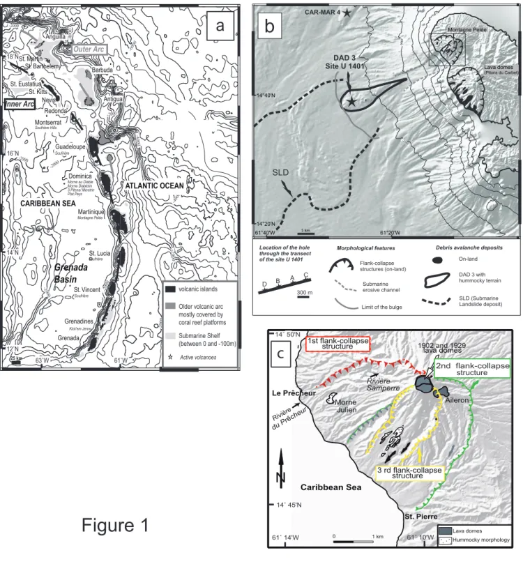
(Fig. 1a). The objectives of the project were 1/ to characterize the voluminous chaotic units 75
identified off the islands associated with the volcanic island landslides (Brunet et al., 2016; Le
76
Friant et al., 2015); 2/ to obtain a complete volcanological history of the surrounding 77
volcanoes and to include the large mass wasting events in the evolution of the volcanoes 78
(Wall-Palmer et al., 2014; Cassidy et al., 2015; Coussens et al., 2016) 79
The aim of this paper is to provide new insights on the last tens of thousands of years of 80
Montagne Pelée’s evolution based on the tephrochonological study of site U1401, sampled 81
during the 340 IODP expedition and located west off Martinique Island, 28 km from the 82
coastline (Fig.1b). By drilling through the DAD the objectives were to characterize and date 83
the setting of the debris avalanche with associated erosional processes. Although it was not 84
possible to drill through the DAD because of the heterogeneity of the deposit and the presence 85
of large blocks (Le Friant et al., 2015), the pelagic sediments and volcanic deposits that 86
covered the DAD were successfully sampled. They thus offer a good opportunity to study the 87
post DAD volcanoclastic sedimentation processes and to better constrain the volcano’s recent 88 evolution.
89 90 91 2. Geological setting 92 93 94
Martinique Island is located in the southern part of the Lesser Antilles arc that result from the 95
subduction of the northern and southern Atlantic plates beneath the Caribbean plate with a 96
relatively slow rate of 2 cm/yr (Wadge, 1984). This southern part of the arc is bordered to the 97
west by the 3000 m deep back-arc Grenada Basin (Fig. 1a). Montagne Pelée, the sole active 98
volcano of Martinique island and one of the twelve active volcanoes of the arc, is located in 99
5
the northern part of Martinique, north of the old Morne Jacob – Pitons du Carbet volcano, 100
(Fig. 1b). It is a famous and tragic volcano as during the first months of the 1902-1905 dome-101
forming eruption the towns of St. Pierre and Morne Rouge were destroyed by a series of 102
laterally directed explosions killing 30 000 inhabitants (Lacroix, 1904). The last eruptive 103
activity was the 1929-1932 lava dome-forming eruption (Perret, 1937). 104
105
Previous works: In the last decades and especially after the 1902-1905 eruption a lot of
106
studies were carried out on Montagne Pelée. Exclusively terrestrial studies were performed 107
until 1998 (Roobol and Smith, 1976; Westercamp and Traineau, 1983a, b; Bourdier et al.,
108
1985, 1989; Boudon and Lajoie, 1989;Boudon, 1993) whereas, after this date, combined on-109
land and marine data were obtained through several cruises, field work and laboratory studies 110
(Deplus et al., 2001; Le Friant et al., 2003, 2015; Boudon et al., 2005, 2007, 2013; Brunet et
111
al., 2016). 112
Based on previous works, the volcanological evolution of Montagne Pelée was divided in 113
three eruptive phases. The first two phases ended in a large flank collapse. (Fig.1c, Le Friant
114
et al., 2003; Boudon et al., 2005, 2007, 2013; Brunet et al., 2016). 115
The first eruptive phase resulted in a first volcanic edifice that was destroyed by a large flank 116
collapse (Le Prêcheur event) that produced a 8 x 6 km large horseshoe-shaped structure 117
(without the invisible southern rim) and a debris avalanche of ~25 km3 that flowed into the 118
Grenada basin (Le Friant et al., 2003; Boudon et al., 2007). Using K-Ar ages acquired from 119
lava domes and lava flows on the northern volcanic edifices of Montagne Pelée and Mont 120
Conil this event was dated at ~127 ka(Germa et al., 2011a). 121
The second eruptive stage created a new volcanic edifice inside and on the southern rim 122
of the first flank-collapse structure. Dome-forming eruptions and associated block- and ash 123
pyroclastic density currents involving acid magmas were the dominant activity of this period. 124
6
This volcanic edifice was destroyed by a second flank collapse (St Pierre event), which 125
generated a horseshoe-shaped structure, 6 x 4 km in size, and a debris avalanche (~13 km3) 126
that flowed like the first one into the Grenada basin. By correlating stratigraphy and 127
magmatology of on-land deposits with tephra layers identified in a piston core (CAR-MAR 4) 128
drilled during the Caraval cruise northwest of Martinique (Fig. 1a), Boudon et al. (2013)
129
proposed a minimum age of 32 ka cal BP for this flank collapse. 130
The third eruptive stage, just after this flank collapse, generated more basic magmas 131
(basaltic andesite), with a high production rate, over several thousand years. After a decrease 132
in the magma production, activity resumed and the magma emitted, after and up to the 133
historic activity of Montagne Pelée, were again as acid as during the second eruptive stage. 134
Plinian to subplinian events and dome-forming eruptions were the two main eruptive styles 135
that occurred during this period. On-land studies recognized 10 plinian to subplinian events 136
and 18 dome-forming eruptions, including the two last historic eruptions, during the last 15 137
000 years of eruptive activity (Roobol and Smith, 1976; Westercamp and Traineau, 1983a, b;
138
Traineau et al., 1989; Smith and Roobol, 1990; Michaud-Dubuy, 2019). But 139
tephrochronological studies of the CAR-MAR 4 piston core showed that the number of 140
volcanic events identified on-land was underestimated particularly for the period prior to 141
5 000 years BP (Boudon et al., 2013).
142
During this third stage, a new flank-collapse occurred on the southwestern flank of the 143
volcano (Rivière Sèche event). Lower in volume than the previous ones (~2 km3), the debris 144
avalanche flowed and stopped at the base of the submarine flank and exhibits a typical 145
hummocky morphology. U-Th dating on lava dome located inside the structure gives an age 146
of ~9 ka for this event (Le Friant et al., 2003). 147
On the basis on IODP core analysis, Le Friant et al. (2015) and Brunet et al. (2016) stated 148
that for the first flank collapse affecting Montagne Pelée volcano the debris avalanche entered 149
7
the sea, flowed over the submarine volcano slope, to stop and deposit around the slope break. 150
This first - and the largest - debris avalanche deposit loaded, weakened seafloor sediment. 151
Resulting submarine landslide propagates along a decollement surface, deforming in situ 152
alternation of hemipelagic sediments and turbidity deposits (Fig 1b). The debris avalanche 153
deposit generated by the second flank collapse may have locally remobilized sediments within 154
the submarine landslide deposit, by exerting normal stress that triggered the deformation 155
process. 156
157 158
3. Materials and analytical methods
159 160
4.1. Coring and on-board observations
161 162
The site U1401 consists of four different holes drilled along a transect 900 m long, NW-163
SE direction, above the debris avalanche deposits (DAD) associated with the last flank 164
collapse generated by Montagne Pelée volcano (Fig. 1b). The hole U1401A, (14°39.10′N, 165
61°25.08′W; 2590 mbsl), is the longest of the four drilled holes at 15.61 m recovered length, 166
and has been chosen for this study. For each hole (example: U1401A), several 9 m long cores 167
were collected (example U1401A- 1H) and were cut in sections with a maximum length of 168
1.5 m (example: U1401A - 1H1). Each section was sawn lengthwise. One half was stored as 169
an archive (GCR – USIO, Texas A & M University College Station, Gulf Coast Repository) 170
and the other half was used for physical properties (magnetic susceptibility, gamma-ray 171
attenuation density, P-wave velocity), chemical analysis and lithological descriptions. On-172
board each core was precisely described by sedimentologists and volcanologists in terms of 173
sedimentology, lithology and volcanic structures. 174
8 175 4.2. Sampling 176 177
For specific analysis, samples were taken according to their position in each section of 178
the core (example U1401A - 1H4, 93/95cm). A systematic sampling (every 10 cm) of the 179
hemipelagic sediments was carried outall along the core for δ18O chronostratigraphy. For 180
lithological and chemical analyses of volcanic deposits, samples were taken from each deposit 181
that was visually identified within the core. In case of thick turbidity deposit, two or three 182
samples were taken, at the base, the middle and the top of the deposit, to observe potential 183
lithological variations. 184
185
4.3. On board physical properties
186 187
Magnetic susceptibility measurements were realized with the multisensor track (MST) 188
aboard the Joides Resolution. Closely spaced measurements (one point every 3cm) were 189
collected on the four cores of the site U1401. Magnetic susceptibility measurements provide 190
information on the content of magnetic minerals of each measured lithological level. Thus it 191
is possible to distinguish hemipelagic mud, characterized by a low amount of magnetic and 192
paramagnetic particles, from tephra layers and volcanic turbidity deposits, significantly 193
enriched with magnetic particles. 194
Gamma – ray attenuation density measurements were performed with the DSDP GRAPE 195
hardware and software. The system consists of a specific instrument that moves a section of 196
core in between a gamma-ray source and a detector. Measurements are based on the direct 197
correlation between the gamma-ray attenuation and the bulk density of the sample, which is 198
9
an indicator of lithological changes (minerals, grain size, porosity). The higher the bulk 199
density of the sample is, the higher is the attenuation. 200
Physical properties data need to be corrected due to data related to technical problems 201
occurring during measurements when moving from one section to another (i.e. aberrant 202
density values lower than 1 g/cm3). For this reason, acquired measurements on a slice of 20 203
cm at the boundary between two successive sections were systematically removed. 204
We focused on magnetic susceptibility data as they exhibit more sensitive variations 205
along the core. Detailed information about lithological changes at a small scale (1 to 10 cm) 206
and identification of tephra layers within each section can be obtained using this dataset. 207 208 3.4. 18O stratigraphy 209 210
To assess chronology of the volcanic deposits, hemipelagic sediment was sampled every 211
10 cm all along the core. However, the presence of thick turbidity deposits prevented us from 212
keeping a constant sampling interval all along the core. Turbidity deposits will be taken into 213
account in the interpretation of δ18O curves. After being dried for about 12 hours at 70°C, 214
each sample was divided in two equal parts, one used for measurements and the other saved 215
as an archive. The former fraction was then weighed, sieved under water in a 40 µm stainless 216
steel sieve to remove fine particles, then dried again and finally weighed a second time. This 217
fraction was then divided in two halves, one for δ18O chronostratigraphy and 14C dating, the 218
second for lithological and mineralogical analysis. 219
For δ18O chronostratigraphy, 3 to 4 planktotic foraminifera from the specific species of 220
Globigerinoides ruber (Alba White, D’Orbigny, 1839) were hand-picked in the fraction 250-221
315 µm. Isotopic δ18O analyses of foraminifera samples were performed at ISTeP (Sorbonne 222
Université), with a 3kV-Delta V Advantage IRMS attached to a Kiel IV Carbonate Device. 223
10
Isotope values are reported in conventional delta (δ) notation as per mil (‰) deviations of the 224
isotopic ratios (18O/16O) calculated to the VPDB scale using an inhouse standard (Carrara 225
Marble) calibrated against NBS-19. Standard deviation (1σ) for δ18O measurements is 0.07 226 ‰. 227 228 4.5. 14C dating 229 230
On the basis of the δ18O curve, 14C dates allow us to obtain absolute ages on key points of 231
the curve to “calibrate” the timescale. For 14C dating, 1000 planktonic foraminifera (about 14 232
mg required for spectrometer detection limit) were hand-picked in the fraction 250-315 µm of 233
each sample. The 14C analyses were performed at the French National AMS-ARTEMIS-234
LMC14 facility (Artemis Accelerator Mass Spectrometer, Saclay Laboratory, Université 235
Paris-Saclay, France). The 14C dating have been converted into calendar years using the Intcal 236
09 calibration record (Reimer et al., 2009; Hughen et al., 2004) taking into account the marine 237
reservoir age correction of 400 years. 238 239 4.6. Lithological data 240 241
Lithologic analyses of turbidity deposits and tephra layers were performed on selected 242
samples, chemically attacked with HCl (0.1 mol) to disaggregate all carbonate microfossils 243
and carbonate non biogenic particles, rinsed with de-ionized water, dried and weighed. To 244
remove all remnant fine particles, samples were then sieved in de-ionized water with a 40 µm 245
stainless steel sieve, dried again for about 24 hours at 70°C, and weighed a second time. Each 246
sample was divided in two equal parts, one fraction used for lithology and the other for 247
geochemistry. Counting for lithology was done on 46 samples on the fraction > 125µm on a 248
11
basis of at least 400 particles/sample on a quadri plate under a binocular microscope. Five 249
classes of clasts were identified: pumice and glass shard particles, scoria clasts, lava dome 250
clasts, oxidized and hydrothermalized clasts and crystals (feldspars, orthopyroxenes, 251
clinopyroxenes, amphiboles, oxides). The objective of counting is to identify the peak of 252
abundance of the different volcanic clasts (scoria, pumice or lava domes clasts); They allow 253
us to link the deposit to a specific eruptive style (pumices with plinian eruptions, scorias with 254
explosive eruptions with more basic magma, and dense clasts with lava dome eruptions) and 255
find some benchmark levels in the core. Counting precision has been estimated counting 6 256
times 6 different samples. The error linked to the operator is of about 10% based on the 257
counting of the same sample by three different operators. The background signal was 258
estimated counting about 400 clasts in some hemipelagic fractions of the core. 259
Moreover, detailed textures of volcanic clasts (vesicularity, microcristallinity) have been 260
investigated using Back-Scattered Electron (BSE) images of pumice, scoria and lava dome 261
clasts with a ZEISS-Supra 55 SEM (ISTeP, Sorbonne Université, Paris). Imaging was 262
performed with an acceleration voltage of 15kV and a probe current of 5 nA. 263
264
4.7. Geochemical data: glass composition
265 266
Pumice and scoria clasts from each peak of abundance along the core were hand-picked 267
in the sample fraction reserved for geochemistry, embedded in resin and polished. Major 268
element composition of matrix glass was determined in 10 different tephra layers and 10 269
turbiditic levels using a CAMECA-SX 100 electron microprobe (Service Camparis, Paris, 270
France). Analyses were performed with an acceleration voltage of 15 kV and a beam current 271
of 4 nA. Counting time was of 5s on Na to limit Na migration, 10s for Si, Ti, Al, Fe, 272
Mn,Mg,Ca, K, P and 15s for Cl. As recommended, we analyzed a minimum of 20 different 273
12
glass shards per level. However, depending on the level, between 5 and 30 glass shards were 274
kept after detailed investigations of glass composition to discard analyses that represent bias 275
data due to microlite composition. 276
The purpose of analysing chemical composition of pumice and scoria peaks is to 277
precisely identify the chemical composition of tephra along the core in order to compare them 278
with those of on-land products known for recent Montagne Pelée activity (Westercamp and
279
Traineau, 1983b; Fichaut et al., 1989). No data has been acquired on lava dome clasts since 280
they are too microcrystallized. 281 282 283 4. Results 284 285 5.1. Core description 286 287
Cores from hole U1401A, 15.61 m long, were described using core logs and photos 288
obtained on-board during the cruise. The close-up photograph of the section U1401A-1H and 289
a synthetic core description of the whole core are presented in Fig. 2. It consists of a series of 290
volcanoclastic sediments intercalated in hemipelagic mud made of silt and clays (Fig. 2a). We 291
can distinguish two types of volcanoclastic deposits: volcanoclastic turbidity deposits and 292
tephra layers. 293
Turbidity deposits are a few tens of centimeters to several meters thick. They are of dark 294
color, massive or normally graded, with various grain-sizes depending on the position in the 295
core. 10 turbidity deposits are present in the core, named T1 to T10, from top to bottom (Fig.
296
2a, b). In the upper part of the core down to 5 m, turbidity deposits are few, thin, fine-grained 297
and massive, with thickness ranging from 15 cm to 130 cm. The upper one, T1, is 50 cm 298
13
thick, massive and dark deposit at the top of the core. It covers unconsolidated brown 299
hemipelagic mud which corresponds to the recent hemipelagic mud observed generally at the 300
top of cores. Below 5 m, turbidity deposits are thicker, coarse-grained, normally graded and 301
more abundant. Below 10 m, the whole core is made of turbidity deposits without intercalated 302
hemipelagic mud. The last four turbidity deposits (T7 to T10) are significant not only for their 303
thickness but also for their grain-size. These turbidity deposits are normally graded, with large 304
size particles (up to 5 cm) at the bottom and small size particles at the top. 305
24 tephra layers were identified in the first 8 m of the core. They are of dark color, sandy, 306
a few cm thick, mainly interbedded in hemipelagic levels or more rarely in turbidity deposits. 307
In the lower part of the core, tephra layers are scarce or totally absent. 308
19 levels of hemipelagic sediments can be recognized in the first 10 m (Fig. 2a, b); they 309
have clear sand color and thickness ranging from ~2-6 cm to ~70 cm. They are usually 310
deformed or distorted, probably due to coring effects. 311
312
5.2. Physical properties analyses
313
314
Results from magnetic susceptibility and GRA (Gamma Ray Attenuation) density 315
evidence adequate correlations between the two sets of values (Fig. 3). Turbidity deposits 316
exhibit important variations in magnetic susceptibility (2500 to 4000 *10-5 SI) and GRA 317
density (0.5 to 2 g/cm3) (Fig. 3a). This is likely related to the coarse-grained characteristic of 318
the basal part of the turbidity deposits leading to the poor ability of large size particles to 319
ensure compaction and a lack of mineralogical sorting. Hemipelagic sediments show the 320
largest amplitude in variations in physical properties with low values of about 1000-1500 *10 -321
5 SI for magnetic susceptibility and < 1.5 g/cm3 for GRA density (Fig. 3a). A detailed view of 322
section U1401A-1H2 (Fig. 3b) enables us to precisely analyze magnetic susceptibility 323
14
variations at a centimeter scale. Six negative peaks are identified for hemipelagic parts of the 324
section, one main positive peak for turbidity deposit and six correspond to thin tephra layers 325 (Fig. 3b). 326 327 5.3. Lithology 328 329
Counting of 46 samples of tephra layers and turbidity deposits along the core were 330
performed in order to characterize the lithological composition of the different volcanoclastic 331
deposits (Fig. 2b). The most representative type of particles in the tephra layers are lava dome 332
clasts. 16 different peaks can be recognized and their abundance is mostly higher than 30%, 333
with maximum values at about ~96%. 334
Abundance of pumice clasts ranges from 0 to 95% all along the core. 6 pumiceous peaks can 335
be identified: 4 in the shallow part of the core with pumice content of 88-95 % (at a depth of 336
95, 163, 240 and 300 cm respectively) and 2 in its deeper part (at a depth of 700 and 800 cm) 337
showing pumice percentages of less than 50%. Scoria clasts are in low abundance (10-15%) 338
except for three scoria peaks (45-60%) at a depth of 688, 713 and 766 cm. Lithology of the 339
major volcanoclastic turbidity deposits is dominated by lava dome clasts (80 to 98 %). 340
341
5.4. δ 18O stratigraphy and 14C dating
342 343
δ18O analyses on planktonic foraminifera (Globigerinoides ruber - white) of hemipelagic 344
sediments exhibit fluctuations ranging from -2.52‰ (at 286 cm depth) to a maximum value of 345
0.07‰ (at 650 cm depth; Fig. 2c). 3 remarkable points were chosen for 14C dating (red dots in 346
Fig. 2c) : a steep negative peak of - 0.75‰ (at 290 cm depth), the maximum positive peak of 347
0.07‰ (at 650 cm depth) and the final last hemipelagic layer of the core of -0.60‰ (at 965 348
15
cm depth). For these three points, 14C dating returned estimated ages of 8082 ± 86 years cal. 349
BP, 24677 ± 172 years cal. BP and 36425 ±191 years cal. BP respectively (after calibration 350
with intcal 09.14c, Reimer et al, 2009). 351
352
5.5. SEM observations
353 354
Textures of pumice, scoria and lava dome clasts were obtained by BSE imaging (Fig. 4). 355
Clasts present large differences in size, shape and vesicularity. Lava dome clasts (Fig. 4a) are 356
poorly vesiculated, with highly microcrystallized matrix glass. On the contrary, pumice clasts 357
(Fig. 4b) are vesiculated with glassy matrix glass and thin bubble walls. Scoria clasts (Fig. 4c) 358
are moderately vesiculated, with more contorted vesicle shape, larger bubble walls and more 359
microcrystallized matrix glass than in pumice clasts. 360
361 5.6. Geochemistry 362 363
Major element compositions were measured in the main pumiceous and scoriaceous 364
tephra layers and their matrix glasses exhibit few variations in composition (Table 1). For 365
pumice clasts, silica content is centered at rhyolitic values of about 73-78 wt% SiO2 (Fig. 5a) 366
with a total alkali content of about 5 wt%. Contrariwise, scoria clasts from tephra layers and 367
turbidity deposits (T8, T9 and T10) show an extended compositional variability from andesite 368
(67 wt% SiO2) to rhyolite (74 wt% SiO2) with 6-7 wt% alkali content (Fig. 5a). 369 370 371 5. Discussion 372 373
16
6.1. Marine chronostratigraphic framework of the core U1401A
374 375
The chronostratigraphical record of core U1401A is first compared to a previous well-376
established tephrochronological one from a deep-sea sediment core CAR-MAR 4, collected 377
50 km northwest and downwind off Martinique Island (Fig. 1b) during the CARAVAL cruise 378
in 2002 (Boudon et al., 2013). This core is in a steadier environment for sedimentation than 379
that of the core U1401A, on a high point and outside the flow zones of debris avalanche and 380
turbidity currents. For these reasons it may be used as a reference for our tephrochronological 381
study in order to estimate the time period registered by the core U1401A. As the base of the 382
core U1401A is located on the roof of the debris avalanche deposit related to the third flank 383
collapse of Montagne Pelée, the tephrochronogical investigations will also provide constrains 384
on a minimum age of the flank collapse. 385
CAR-MAR 4 is a 10.6 m long core, characterized, from top to bottom, by 7 m of 386
continuous sedimentation with thick hemipelagic layers, tephra layers and no turbidity 387
deposits followed by 3.6 m of disturbed and unstructured sedimentation (Boudon et al., 2013). 388
Only the first 7 meters were investigated for tephrochronological studies. CAR-MAR 4 δ18O 389
results have already been correlated with a well-dated nearby deep-sea core (EN32-PC6, 390
Broecker et al., 1990). The correlation shows that CAR-MAR 4 covers the last 32 cal. ka BP 391
(Fig. 6). We can use it as a reference curve for U1401A because the two cores are spatially 392
close and analyses have been realized on the same planktonic foraminifera species and with 393
the same analytical protocol for both. Owing to the presence of thick turbidity deposits in the 394
core U1401A, to establish an adequate correlation with the CAR-MAR 4 δ18O curve, it is 395
necessary to subtract the thickness of the turbidity deposits. This allows us to obtain a real 396
chronostratigraphic scale for hemipelagic deposits. 397
17
A spectral analysis and a correlation between the two cores have been processed using 398
the free software Analyseries (Paillard et al., 1996). This software enables us to compare our 399
δ18O data with the selected reference CAR-MAR 4 curve by selecting and comparing a series 400
of calibration points between the two curves. From the calibration points, Analyseries realizes 401
a linear intercalibration to calculate the age of the intermediate points of the curve. It takes 402
into account the age and the depth of the two calibration points up and down the intermediary 403
one, and the depth of the intermediary point, according to the equation: 404
AgeX= [(ageA – ageB) / (depthA – depthB)]*[depthX – depthA] + ageA
405
where X is the intermediary point, A the upper calibration point and B the lower calibration 406
point. 407
In the final age model (Fig. 6), the two curves are correlated with a coefficient of 0.936 408
and correlation returns a mean pelagic sedimentation rate of 22cm/ka, consistent with that 409
known for the Grenada basin (Reid et al., 1996; Boudon et al., 2007). From the modelled 410
ages, the core U1401A covers a period from 0 to ~36 cal. ka BP, with a maximum δ18O value 411
(0.07 ‰) at about 25 cal. ka BP. The overlap of the two curves is clear especially in the first 412
part (0-8 ka). However, for recent ages, a small shift is evident between the two cores (Fig. 6): 413
the modelled ages of the core U1401A are younger than those of CAR-MAR 4. This proves 414
that the core U1401A recorded the largest temporal range, probably because of the presence 415
of a thick turbidity deposit (T1, 50 cm thick) at the top of the core that allowed the 416
preservation of the youngest and not compacted sediments, usually destroyed by drilling 417
processes. 418
Another difference between the two cores is the sampling frequency used for δ18O 419
chronostratigraphy. The sampling interval for the core CAR-MAR 4 is constant at 10 cm 420
while the sampling interval could not be kept constant for the core U1401A. Sampling the 421
core U1401A led to two types of problems: (1) the presence of numerous and thick turbidity 422
18
deposits and (2) the low content of the planktonic foraminifera Globigerinoides ruber in 423
many samples. These problems can be explained by the particular position of the U1401 site, 424
located on the submarine flank of the volcano. As a result the site is more exposed to clastic 425
and clayey sedimentation related to on-land processes, which induce a decrease in biogenic 426
steady-state sedimentation. Secondly, the presence of thick turbidity deposits has a significant 427
impact on the sedimentary record of U1401A core. The correlation between the two cores is 428
lost when turbidity deposits are present (Fig. 6). In fact, some significant gaps occur, causing 429
a lack of thousands of years in the sedimentary record. A strong erosive power of turbidites 430
can probably be invoked during their deposition process. 431
Three 14C dates were performed to obtain absolute ages on 3 key positions of the 432
U1401A core (Figs 2c, 6). They are roughly located at the top, the center and the bottom of 433
the core (respectively at 197, 348.5 and 488.5 cm turbidity deposits off depths). These 3 434
points have been selected as they represent a particular milestone in the evolution of the δ18O 435
curve. In addition, dating the top and bottom of the curve allows us to obtain the entire 436
coverage period of the core and an absolute age for the sediments located on the DAD.The 437
most recent age obtained (8220 cal. ka BP) is well consistent with the model obtained with 438
δ18O analysis. It corresponds to a positive peak in the δ18O record. The second 14C age of 439
24677 cal. ka BP corresponds to the higher value of the δ18O obtained in the core U1401A. If 440
we compare with the CAR-MAR 4 curve where the higher value of the δ18O curve is obtained 441
at a more recent age (~18 ka), the maximum value of the U1401A δ18O curve is probably too 442
high (Fig. 6a). This is likely related to the lack of points in the δ18O record due to the erosion 443
by turbidity density currents during the 17-24 ka period where the maximum δ18O value is 444
reached. The third 14C age of 36425 cal. ka BP corresponds to the lowest point sampled in a 445
small hemipelagic deposit interbedded between T7 and T8 turbidity deposits and overlaying 446
the top of the debris avalanche deposit (T8 to T10) of the U1401A core. As this third age is 447
19
obtained on the lowest hemipelagic level of the core but not really at its physical bottom, our 448
results of ~36 cal. ka BP represents a minimum age for the occurrence of the third flank 449
collapse of Montagne Pelée, that significantly contrasts with what was thought up to now. 450
Nevertheless below this point three thick turbidity deposits (T8 to T10) are present. They 451
overly the top of the debris avalanche deposit. No hemipelagic sediments are identified 452
between these turbidity deposits or at the top of the debris avalanche deposit. These 453
observations lead us to believe that it is likely that turbidity deposits T8 to T10 formed in a 454
short period of time directly after the flank collapse event. 455
456
6.2. Tephrochronology, stratigraphy and eruptive styles
457 458
Figure 7 shows the complete estimated chronostratigraphic model of the core U1401A. 459
24 tephra layers and 10 turbidity deposits have been recognized all along the core by cross 460
correlation of photos observations, counting techniques and analysis of physical properties. 461
The comparison of tephra record between the core U1401A and the core CAR-MAR 4 is 462
showed in Figure 6. 463
The core U1401A can be divided in three different units. In the first unit, 0-3 m in depth 464
(0 to 9 cal. ka BP), 2 turbidity deposits can be recognized (Fig. 7, T1= 50 cm and T2= 10 cm). 465
The first turbidity deposit (T1) is located at the top of the core, covering the recent and not 466
compacted hemipelagic sediments. Its peculiar position allows it to be linked to the last period 467
of volcanic activity characterized by the last 1902-1905 and 1929-1932 dome-forming 468
eruptions. In addition, its lithology (prevalence of lava dome’s clasts) is similar to that of on-469
land pyroclastic density current deposits (Bourdier et al., 1989). This unit is also characterized 470
by the occurrence of 10 tephra layers (Fig. 7, red lines = 4 pumice clast-rich levels and blue 471
lines = 6 lava dome clast-rich levels) interbedded in the hemipelagic sedimentation. Such 472
20
alternation of pumice clasts and lava dome clasts-rich levels is consistent with 473
tephrochronological results on the core CAR-MAR 4 (Fig. 6b, Boudon et al., 2013) and with 474
observations on on-land deposits that show the well-known alternation between dome-475
forming eruptions and plinian or subplinian eruptions (P1 to P8 eruptions, Westercamp and
476
Traineau, 1983a, b; Traineau et al., 1989 Michaud-Dubuy, 2019). The residual glass of the 477
pumice clasts from these tephra layers has rhyolitic composition (about 75 wt% SiO2 and 5 478
wt% Na2O+K2O) which is close to the composition of the residual glass of the pumice clasts 479
from on-land deposits (Fig. 5b). Furthermore their composition is clearly far from that of 480
Dominica island (SiO2 ~78 wt%, Na2O+K2O ~5-7 wt%, Balcone-Boissard et al., 2018) and 481
clearly excludes tephra originating from Dominica volcanoes, even though more 482
investigations have to be performed using trace elements proxies. We see that the record of 483
eruptive events is lower in the core U1401A than for the core CAR MAR4 and also for on-484
land record (Fig. 6). This is due to the location of the site U1401 not in the axis of the main 485
local windward direction of the winds (westbound trade) and to the dispersion of the plumes 486
from plinian and subplinian eruptions or ash-clouds associated to block- and ash pyroclastic 487
density currents. 488
The second unit of the core, 3 to 8 m in depth (9 to 30 cal. ka BP) is characterized by 489
well-spaced turbidity deposits (Fig. 7, T3 to T6) in thick hemipelagic layers. Their thickness 490
varies from 10 cm (T4) to 120 cm (T5). Lithology of T3 and T5 shows the prevalence of lava 491
dome’s clasts; they are probably linked with block- and ash pyroclastic density currents 492
associated to dome-forming eruptions. A total of 14 tephra layers can be documented in this 493
unit. Only 3 tephra layers enriched in lava dome clasts are recognized in the first half of the 494
second unit (Fig. 7, blue lines) whereas 11 tephra layers are present in the second half. 6 of 495
them are rich in dome clasts (blue lines), 2 rich in pumice clasts (red lines), whereas 3 of them 496
contain scoria clasts (green lines). In these tephra, the residual glass of scoria clasts is more 497
21
basic than the residual glass of the pumice clasts (~65 wt% SiO2, Fig. 5a), but we also 498
observed some clasts that exhibit a more evolved composition (~75 wt% SiO2) – see 499
explanation in the next section. The lack of tephra records between 5 and 6.7 m in this unit 500
may be related to a decrease in volcanic activity, or the set-up of thick turbidity deposits that 501
eroded a part of the previously deposited sediments. 502
The third unit of the core, 8 to 15 m in depth (30 to 36 cal. ka BP) is almost exclusively 503
characterized by thick turbidity deposits (T7 to T10). Their thickness varies from 140 cm (T7) 504
to 230 cm (T8). Lithological results highlighted that these turbidity deposits are rich in lava 505
dome’s clasts but also in scoria clasts (about 10 to 20 %). The absence of hemipelagic 506
sediments in this part of the core indicates a significant supply of volcanic products in a short 507
time interval. 508
509
6.3. Origin of the scoria-rich levels
510 511
Complete results on U1401A core show that the turbidity deposits and some of the tephra 512
layers from the bottom of the core are rich in scoria clasts (up to 60% of the clasts in the 513
sections between 680 and 820 m depth) of more basic composition (~65 wt% SiO2). The 514
proportion of scoria clasts decreases progressively to the top of the core rarely being over a 515
background content of 5% of clasts. 516
Based on tephrochronological study of the CAR-MAR 4 core (Fig. 6b) and on-land data, 517
Boudon et al. (2013) have proposed that abundant deposits of scoria flows of basaltic 518
andesitic composition were generated after the second flank collapse event, estimated around 519
32 ka, whereas acid andesitic magma were emitted before this flank collapse event. These 520
changes in composition and eruptive style are explained by the decrease of the threshold 521
effect exerted by the volcanic edifice on the magma plumbing system allowing more basic 522
22
and denser magmas to reach the surface (Pinel and Jaupart, 2005; Boudon et al., 2013,
523
Cassidy et al., 2015). This activity occurred over several thousand years, rapidly building a 524
new cone inside the horseshoe-shaped structure. This also shows that the magma production 525
was high just after the flank collapse and gradually decreased during the building of the new 526
cone and progressively exerted a new threshold effect on the plumbing system. The magma 527
production is then probably reduced for a few thousand years before resuming with the 528
production of more acidic and less dense magmas. The ages proposed for this period of 529
basaltic andesite emissions range between 32 cal. ka BP or more and 27 cal. ka BP. A period 530
of weaker magmatic activity occurs between 27 to 22.5 cal. ka BP prior to a new emission of 531
andesites from 22.5 cal. ka BP to present (Boudon et al., 2013). 532
The on-land relationship between the horseshoe-shaped structure of the second flank-533
collapse and the scoria pyroclastic density currents were not clearly established as the scoria 534
pyroclastic density currents which resulted from column collapse of explosive eruptions, 535
covered all the flanks of the volcano inside and outside the horseshoe-shaped structures. 536
Considering 1) the estimated ages of the on-land scoria pyroclastic density currents 537
(Westercamp and Traineau, 1983a, b), the age of the tephra levels rich in scoria clasts in the 538
CAR-MAR 4 core band the ages obtained on the turbidity deposits and tephra level rich in 539
scoria clasts of the U1401A core; 2) the similar composition of the residual glass of these 540
scoria clasts in the cores and on-land, we can assume that all these deposits belong to the 541
same period of activity of Montagne Pelée and the production of basaltic andesites during this 542
period did not follow the second but the third flank collapse as the site U1401 is located on 543
the third DAD. 544
We also observe that even if the emitted magmas are dominantly basaltic andesites, they 545
can be associated with more evolved magmas of dacitic composition with rhyolitic glasses 546
(Fig. 5). This characteristic has already been evidenced on-land for these eruptions (Traineau
23
et al., 1983; Bourdier et al., 1985) and explained by the presence of more superficial and 548
small pocket of more evolved magmas within the “mushy” plumbing system impacted by the 549
ascent of more basic magmas stored deeper (Pichavant et al., 2002). This magma mixing 550
generally occurred at the beginning of the eruptive phases. 551
552
5.4. Age of the third flank collapse and relationship with the volcanic activity
553 554
Our results allow us to propose a significant shift in age of the third flank collapse from 9 555
ka to ~36 cal. ka BP. 556
Considering that the drilling operations of the core U1401A reach the top of the third 557
DAD, and on the basis of the δ18O age model and on the 14C ages we can consider that the age 558
of 36425 ± 191 cal. ka BP obtained in the lowest level of hemipelagic mud is a minimum age 559
for the third DAD and the corresponding flank collapse. But a series of turbidity deposits (T8 560
to T10) are recognized between the last dated hemipelagic mud and the top of the debris 561
avalanche deposits. Thus it is possible to raise the question of the time interval separating this 562
14C age from the true age of the flank collapse. 563
As previously proposed, the decrease of the load exerted by the third flank-collapse has 564
led to the production of scoria rich deposits of basaltic composition and to a high magma 565
production rate. This high magma production rate generated abundant scoria pyroclastic 566
density currents that entered the sea and evolved in turbidity currents. This explains the 567
abundance and the thickness of the turbidity deposits recognized at the base of the U1401A 568
core and on the debris avalanche deposit. This abundance of volcanic products generated after 569
the flank-collapse supports rapid deposition from the turbidity currents (T8 to T10). We can 570
consider that the time between the flank collapse and the ascent of more basic magmas is not 571
too long (probably not more than a few decades) and that the age of 36.425 cal. ka BP 572
24
obtained on the hemipelagic mud covering these turbidity deposits is a minimum age not so 573
far from the true age of the debris avalanche setup. 574
575
5.5. The recent eruptive history of Montagne Pelée
576 577
Previous studies have described the eruptive history of Montagne Pelée as the succession 578
of three different phases of construction of the volcanic edifice, separated by two flank 579
collapses (Fig. 8a); the third flank collapse, is in fact included in the third stage of building 580
(Le Friant et al., 2003; Boudon et al., 2005, 2007, 2013; Germa et al., 2011a). On the basis of 581
on-land studies, the three different flank collapses had previously been dated at 127 ka 582
(Germa et al., 2011a) for the first one, 32 ka (Boudon et al., 2013) and 9 ka (Le Friant et al.,
583
2003), respectively for the second and the third one. 584
Nevertheless, the results of our study significantly modify the volcanological evolution of 585
Montagne Pelée and allow us to submit a new evolution for the volcano (Fig. 8b). On-land, 586
several rims of flank collapse structures have been identified (Fig. 11 of Le Friant et al., 2003
587
and Fig 1c). The rims resulting from the first flank-collapse structure are clearly identified, 588
though its southern rim is not visible as it is covered by the products of the most recent 589
volcano activity. Rims of the third flank collapse structures are clearly identifiable as they are 590
the most recent, but they are also partially covered by recent volcanic products. On the 591
contrary, the scars originating from the second flank collapse structure are not clearly visible 592
and remain questionable on the basis of on-land investigations. Recent offshore studies 593
following the IODP expedition 340 have shown that the DADs do not have the extension 594
previously proposed (Le Friant et al., 2015; Brunet et al., 2016). The large chaotic deposits 595
identified on seismic profiles and on bathymetry are deformed sediments pushed by the DAD 596
that stopped at the base of the submarine flank. It is difficult to distinguish the DADs of the 597
25
first and the second event because they form a unique bulge at the base of the submarine flank 598
of the volcano (Fig 1b). On the contrary, the third DAD is clearly identified on the submarine 599
flank of the volcano with its lobe-shape and its hummocky morphology. 600
The question of the occurrence of three flank collapse events can thus be addressed in a 601
serious manner. The morphology and the distribution of the valleys indicate that the northern 602
rim of the first flank collapse structure exists. Its age of 127 ka (Germa et al., 2011a) obtained 603
on two lava domes on each part of the rim is reliable. The third flank collapse is now also 604
clearly identified by the presence of submarine DADs, some remnants of hummock 605
morphology on-land and the rims of the horse-shoe shaped structure (Le Friant et al., 2003). 606
Its age is now confidently set at ~36 ka (this study). The time interval that separated the first 607
(127 ka) from the third flank collapse (~36 ka) is in the order of 90 ka. Is this short period 608
enough to build a new cone destroyed by a second flank collapse and a third cone destroyed 609
again by the third one? It is difficult to answer this question as the data we produce in this 610
study concern the last 40 000 thousand years. However the magma production rate of 611
Montagne Pelée is, although significant, not very high and can be estimated at a few km3/10 612
000 years for the last tens of thousands of years (Wadge, 1984, Michaud-Dubuy, 2019). We 613
can consider that the highest magma production rate occurred after the flank collapse event 614
dated now at ~36 ka over a period of 10 000 years. An alternative to the already proposed 615
evolution of the volcano - that must be confirmed by on-land work and additional 616
tephrochronological investigations on other marine cores in the period between the first and 617
the “third” flank collapse - is that only two flank collapses occurred (Fig. 8b): the first one 618
at127 ka, and the last one at 36 ka. Though less voluminous, this last flank-collapse modified 619
the dynamics of the magmatic plumbing system, leading for a short period of time to the 620
ascent of more basic and denser magma than those emitted before the flank collapse. 621
Following this flank collapse, a lot of explosive eruptions produced scoria fall and density 622
26
currents covering a large part of the volcano. Numerous turbidity currents were generated by 623
scoria density currents entering into the sea or by the remobilization of scoria density current 624
deposits, covering part of the submarine flank of Montagne Pelée. The eruptive activity was 625
high just after the flank-collapse and decreased progressively. The significant eruptive activity 626
rapidly involved the building of a new volcanic edifice which exerted a new threshold effect 627
on the plumbing system. The volcanic activity decreased and progressively a change in the 628
composition of the emitted magmas occurred; more acidic magmas were generated giving rise 629
to the alternance of plinian or subplinian events and dome-forming eruptions up to this day. 630 631 632 6. Conclusions 633 634
The detailed study of the core U 1401a located on the submarine flank of Montagne 635
Pelée, on the hummocky deposit of the third debris avalanche (DAD 3) has improved our 636
knowledge of the eruptive history. It has allowed us to propose a minimum age of ~36 ka for 637
the last flank collapse. It also indicates that the volcanic activity can be modified in terms of 638
magma production and in terms of magma composition after a flank collapse. Deeper and 639
more basic magmas can erupt for a long time before a new cone exerts a threshold effect on 640
the plumbing system, reducing the magma production rate and changing the composition of 641
the emitted magmas. It also indicates that after a flank collapse, a lot of turbidity currents can 642
occur resulting in the offshore evolution of abundant pyroclastic density currents or the 643
remobilization of on-land deposits. It also shows that a sole core does not enable the 644
reconstruction of all the eruptive history of a volcano for a given period. The core U1401 645
located on the western submarine flank of Montagne Pelée is well located for the study of the 646
post flank-collapse activity and the pyroclastic density currents as well as tephra layers. 647
27
Abundant turbidity deposits have an significant erosive power, destroying part of the lower 648
deposits, but can also preserve recent and not compacted hemipelagic sediments, generally 649
not observed, as was the case for the upper recent turbidity deposits. The core CAR MAR 4 is 650
best located to study tephra layers as it is on a high point without erosion and closer to the 651
direction of the winds (East-West) in the troposphere. But a lot of tephra are dispersed to the 652
East as the eruptive column for Plinian eruptions reaches the stratosphere where the wind 653
direction is generally West-Easterly. A core located to the east of Montagne Pelée will allow 654
us to complete the eruptive history of the volcano. 655 656 657 ……… 658 659 Acknowledgments 660
We thank the captains, officers, crews of the R/V Joides Resolution and the IODP-340 661
scientific mission. Major element analyses at the microprobe facility benefited the support of 662
M. Fialin and N. Rividi (Service CAMPARIS). Oxygen stratigraphy analysis benefited the 663
support of N. Labourdette (UPMC). Imaging at SEM was helped by Omar Boudouma 664
(Sorbonne Université). We thank INSU, NERC, ANR-13-BS06-0009 for funding. 14C dating 665
were performed at LMC14 laboratory (Artemis program). We also thank E. Lebas for her 666
participation and help in the acquisition of planktonic foraminifera samples. 667 668 669 References 670 671
28
Allan, A.S.R., Baker, J.A., Carter. L., Wysoczanksi, R.J., 2008. Reconstructing the 672
Quaternary evolution of the world's most active silicic volcanic system: insights from an 673
∼1.65 Ma deep ocean tephra record sourced from Taupo Volcanic Zone, New Zealand. 674
Quat. Sci. Rev. 27(25–26): 2341–2360. 675
Balcone-Boissard, H., Boudon, G., Blundy, J.D., Martel, C., Brooker, R.A., Deloule, E., 676
Solaro, C., Matjuschkin, V., 2018. Deep pre-eruptive storage of silicic magmas feeding 677
Plinian and dome-forming eruptions of central and northern Dominica (Lesser 678
Antilles) inferred from volatile contents of melt inclusions Contrib. Mineral. Petrol. 679
173:101, https://doi.org/10.1007/s00410-018-1528-4. 680
Boudon, G., Lajoie, J., 1889. The 1902 péléean deposits in the Fort Cemetery of St. Pierre, 681
Martinique: a model for the accumulation of turbulent nuées ardentes. In: Boudon, G., 682
Gourgaud, A. (Eds), Montagne Pelée. J. Volcanol. Geotherm. Res. 38:113-129. 683
Boudon, G., Le Friant, A., Villemant, B., Viodé, J.-P., 2005. Martinique. In: Lindsay, J.M., 684
Robertson, R.E.A., Shepherd, J.B., Ali, S. (Eds.), Volcanic Atlas of the Lesser Antilles. 685
Seismic Research Unit, The University of the West Indies, Trinidad and Tobago, WI, 686
pp 65–102. 687
Boudon, G., Le Friant, A., Komorowski, J.-C., Deplus, C., Semet, M.P., 2007. Volcano flank 688
instability in the Lesser Antilles Arc: diversity of scale, processes, and temporal 689
recurrence. J. Geophys. Res. 112, B08205. 690
Boudon, G., Villemant, B., Le Friant, A., Paterne, M., Cortijo, E., 2013. Role of large flank 691
collapses on magma evolution of volcanoes. Insights from the Lesser Antilles Arc. J. 692
Volcanol. Geotherm. Res. 263:224-237. http://dx.doi.org/10.1016/j.jvolgeores. 693
2013.03.009. 694
29
Bourdier, J.-L., Gourgaud, A., Vincent, P.M., 1985. Magma mixing in a main stage of 695
formation of Montagne Pelée: the Saint Vincent-type scoria flow sequence (Martinique, 696
F.W.I.). J. Volcanol. Geotherm. Res. 25:309-332. 697
Bourdier, J.-L., Boudon, G., Gourgaud, A., 1989. Stratigraphy of the 1902 and 1929 nuée 698
ardente deposits, Montagne Pelée, Martinique. In: Boudon, G., Gourgaud, A. (Eds): 699
Mount Pelée. J. Volcanol. Geotherm. Res. 38:77-96. 700
Bouysse, P., Westercamp, D., Andreieff, P., 1990. The Lesser Antilles Island Arc. 701
Proceedings of the Ocean Drilling Program, Part B: Scientific Results 110:29–44. 702
Broecker, W.S., Klas, M., Clark, E., 1990. Accelarator mass spectroscopic radiocarbon 703
measurements on foraminifera shell from deep-sea cores. Radiocarbon 32(2):119-133, 704
Brunet, M., Le Friant, A., Boudon, G., Lafuerza, S., Talling, P., Hornbach, M., Ishizuka, O., 705
Lebas, E., Guyard, H. and IODP Expedition 340 science Party, 2016. Composition, 706
geometry, and emplacement dynamics of a large volcanic island landslide offshore 707
Martinique: From volcano flank-collapse to seafloor sediment failure? Geochem. 708
Geophys. Geosyst .16, doi:10.1002/2015GC006034. 709
Cassidy, M., Watt, S.F.L., Talling, P.J., Palmer, M.R., Edmonds M., Jutzeler, M., Wall-710
Palmer, D., Manga, M., Coussens, M., Gernon, T., Taylor, R.N., Michalik, A., Inglis, 711
E., Breitkreuz, C., Le Friant, A., Ishizuca, O., Boudon, G., McCanta, M.C., Adachi, T., 712
Hornbach, M.J., Colas, S.L., Endo, D., Fujinawa, A., Kataoka, K.S., Maeno, F., 713
Tamura, Y., Wang, F., Ishizuka, O., and Shipboard Science Party, 2015. Rapid onset of 714
mafic magmatism facilitated by volcanic edifice collapse. Geophys. Res. Lett. 42, 715
4778–4785, doi:10.1002/2015GL064519. 716
Coussens, M., Wall-palmer, D., Talling, P.T., Watt, S.F.L., Cassidy, M., Jutzeler, M., Clare, 717
M.A., Hunt, J.E., Manga, M., Gernon, T.M., Palmer, M.R., Hatter, S.J., Boudon, G., 718
30
Endo, D., Fujinawa, A., Hatfield, R., Hornbach, M.J., Ishizuka, O., Kataoka, K., Le 719
Friant, A., Maeno, F., McCanta, M., Stinton, A.J., 2016. The relationship between 720
eruptive activity, flank collapse, and sea level at volcanic islands: A long-term (>1 Ma) 721
record offshore Montserrat, Lesser Antilles. Geochem. Geophys. Geosyst., 722
doi:10.1002/2015GC006053. 723
Deplus, C., Le Friant, A., Boudon, G., Komorowski, J.-C., Villemant, B., Harford, C., 724
Ségoufin, J., Cheminée, J.-L., 2001. Submarine evidence for large-scale debris 725
avalanches in the Lesser Antilles Arc. Earth. Planet. Sci. Lett. 192:145-157. 726
D’Orbigny, A.D. 1839. Foraminifères, in de la Sagra R., Histoire physique, politique et 727
naturelle de l'ile de Cuba.Arthus Bertrand, Paris 224p. 728
Engwell, S.L., Sparks, R.S .J., Carey S. 2014. Physical characteristics of tephra layers in the 729
deep sea realm: the Campanian Ignimbrite eruption. In: Austin, W. E. N., Abbott, P. M., 730
Davies, S. M., Pearce, N. J. G., Wastegard, S. (Eds). Marine Tephrochronology. J. Geol. 731
Soc. London, Special Publication, 398, 47–64. http://dx.doi.org/10.1144/SP398.7. 732
Fichaut, M., Marcelot, G., Clocchiatti, R. 1989. Magmatology of Mt. Pelée (Martinique, 733
F.W.I.). II: petrology of gabbroic and dioritic cumulates. In: Boudon, G., Gourgaud, A. 734
(Eds): Mount Pelée. J. Volcanol. Geotherm. Res. 38:171-18. 735
https://doi.org/10.1016/0377-0273(89)90036-X 736
Germa, A., Quidelleur, X., Lahitte, P., Labanieh, S., Chauvel, C., 2011a. The K–Ar 737
Cassignol-Gillot technique applied towestern Martinique lavas: A record of Lesser 738
Antilles arc activity from 2 Ma to Mount Pelée volcanism. Quaternary Geochronology 739
6:341–355. 740
31
Germa, A., Quidelleur, X., Labanieh, S., Chauvel, C., Lahitte, P., 2011b. The volcanic 741
evolution of Martinique Island: Insights from K–Ar dating into the Lesser Antilles arc 742
migration since the Oligocene. J. Volcanol. Geotherm. Res. 208:122-135. 743
Hughen et al., 2004. Marine 04 marine radiaacarbon age calibration, 0-26 cal kyr BP. 744
Radoicarbon 46:1059-1086. 745
Jenning, A., Thordarson, T., Zalzal, K., Stoner, J., Hayward, C., Geirsdotti, A., Miller, G., 746
2014. Holocene tephra from Iceland and Alaska in SE Greenland Shelf Sediments. In: 747
Austin, W. E. N., Abbott, P. M., Davies, S. M., Pearce, N. J. G., Wastegard, S. (Eds). 748
Marine Tephrochronology. J. Geol. Soc. London, Special Publication, 398, 157-193. 749
http://dx.doi.org/10.1144/SP398.6. 750
Kutterolf, S., Schindlbeck, J. C., Robertson, A. H. F., Avery, A., Baxter, A. T., Petronotis, K., 751
&Wang, K.-L. (2018). Tephrostratigraphy and provenance from IODP Expedition 352, 752
Izu-Bonin arc: Tracing tephra sources and volumes from the Oligocene to recent. 753
Geochemistry,Geophysics,Geosystems,19,150–174. 754
https://doi.org/10.1002/2017GC007100 755
Labanieh. S., Chauvel, C., Germa, A., Quidelleur, X., Lewin, E., 2010. Isotopic hyperbolas 756
constrain sources and processes under the Lesser Antilles arc. Earth. Planet. Sci. Lett. 757
298:35-46. 758
Lacroix, A., 1904. La Montagne Pelée et ses Eruptions. Masson ed., Paris, 662 pp. 759
Le Friant, A., Boudon, G., Deplus, C., Villemant, B., 2003. Large scale flank-collapse during 760
the recent activity of Montagne Pelée, Martinique, FWI. J. Geophys. Res. 108, B1, 2055. 761
Le Friant, A., Lock, E.J., Hart, M.B., Boudon, G., Sparks, R.S.J., Leng, M.J., Smart, C.W., 762
Komorowski, J.-C., Deplus, C., Fisher, J.K., 2008. Late Pleistocene tephrochronology 763
32
of marine sediments adjacent to Montserrat, Lesser Antilles volcanic arc. J. Geol. Soc. 764
London165:279–289. 765
Le Friant, A. et al., 2015. Submarine record of volcanic island construction and collapse in 766
the Lesser Antilles arc: First scientific drilling of submarine volcanic island landslides 767
by IODP Expedition 340. Geochem. Geophys. Geosyst. 16:420-442. 768
doi:10.1002/2014GC005652. 769
Lowe, D.J., 2014. Marine tephrochronology: a personal perspective. In: Austin, W. E. N., 770
Abbott, P. M., Davies, S. M., Pearce, N. J. G., Wastegard, S. (Eds). Marine 771
Tephrochronology. J. Geol. Soc. London, Special Publications, 398, 7-19. 772
http://dx.doi.org/10.1144/SP398.11. 773
Martin-Kaye, P.H.A., 1969. A summary of the geology of the Lesser Antilles. Overseas 774
Geology and Mineral Resources 10(2):172–206. 775
Michaud-Dubuy, A., 2019. Dynamique des éruptions pliniennes : réévaluation de l’aléa 776
volcanique en Martinique. Thèse Université de Paris, 200 pp. 777
Paillard, D., Labeyrie, L., Yiou, P., 1996. Macintosh program performs time-series analysis. 778
Eos, Transactions, Am. Geophys. Union, 77:379 (Abstract). 779
Paterne, M., Guichard, F., Labeyrie, J. 1988. Explosive activity of the SouthItalian volcanoes 780
during the past 80000 years as determined by marine tephrochronology. J. Volcanol. 781
Geotherm Res., 34:153–172, http://dx.doi.org/10.1016/0377-0273(88)90030-3. 782
Paterne, M., Labeyrie, J., Guichard, F., Mazaud, A., Maitre, F. 1990. Fluctuations of the 783
Campanian explosive volcanic activity South Italy during the past 190,000 years, as 784
determined by marine tephrochronology. Earth Planet. Sci. Lett., 98:166–174, 785
http://dx.doi.org/10.1016/0012-821X(90)90057-5 786