HAL Id: tel-00324525
https://tel.archives-ouvertes.fr/tel-00324525
Submitted on 25 Sep 2008HAL is a multi-disciplinary open access archive for the deposit and dissemination of sci-entific research documents, whether they are pub-lished or not. The documents may come from teaching and research institutions in France or abroad, or from public or private research centers.
L’archive ouverte pluridisciplinaire HAL, est destinée au dépôt et à la diffusion de documents scientifiques de niveau recherche, publiés ou non, émanant des établissements d’enseignement et de recherche français ou étrangers, des laboratoires publics ou privés.
Data Engineering: Modeling and Integration Issues
Ana Carolina Salgado
To cite this version:
Ana Carolina Salgado. Data Engineering: Modeling and Integration Issues. Computer Science [cs]. Université de Versailles-Saint Quentin en Yvelines, 2008. �tel-00324525�
Université de Versailles Saint-Quentin-en-Yvelines
Habilitation à Diriger des Recherches
Spécialité Informatique
Data Engineering: Modeling and Integration Issues
Mémoire présenté par
Ana Carolina Salgado
Le 26 Mai 2008
Devant le Jury
Rapporteurs Aris Ouksel Professeur – Université de l’Illinois, USA
Stefano Spaccapietra Professeur – Ecole Polytechnique Fédérale de Lausanne
Patrick Valduriez Directeur de Recherche – INRIA
Examinateurs Zohra Bellahsène Professeur – Université de Montpellier
Mokrane Bouzeghoub Professeur – Université de Versailles Saint-Quentin
iii A meus pais, que me ensinaram o caminho
A meu filho, que me dá forças para continuar
v
Acknowledgements
My first and main acknowledgement goes to Mokrane Bouzeghoub for having me as a member of the team in his research group and who encourages me to write this HDR. He also accepted my students as his, enriching their work with outstanding research directions. All my gratitude to his friendship and kindness.
A special thanks to the rapporteurs, Aris Ouksel, Stefano Spaccapietra and Patrick Valduriez, for their availability to read and contribute to the text. Also, Zohra Bellahsène and Patrick Brézillon who agreed to participate in the evaluating committee, my great thanks.
During the last year I was part of a group that accepted me as one of them. Many thanks to all members of SIAL group. It was really a pleasure to be among them during this period of time. Particularly, I would like to express my appreciation to Zoubida Kedad with whom I shared not only the office but also my research activities, my doubts, my problems,… Thank you very very much, Zoubida, for your friendship and availability. We had a great time together!
My thanks to all the staff of PRiSM.
This report could not be done without the work produced by ALL my students (PhD, MSc and undergraduate) that participated in my research projects. Particularly, I would like to nominate those whose research results are included in this report (in chronological order): Valéria Times, Ricardo Ciferri, Valéria Soares, Bernadette Lóscio, Thiago Costa, Maria da Conceição Batista, Rosalie Belian, Vaninha Vieira, Damires Souza and Carlos Eduardo Pires.
A special thanks goes to the co-authors of my papers, reports, books, book chapters, and other publications.
Finally, I would like to thank all members of my family that always supports me in my personal and professional activities. Particularly, I have a special word to two special people. Tiago, thank you for being who you are. Marco, thank you for being on my side.
vii
Abstract
This report includes the main results in three research areas we have been working on since 1989: Geographical Databases, Data Integration and Semantic Issues in PDMS (Peer Data Management Systems).
A Geographical Database is a collection of inter-related and geo-referenced data. By definition, it is a database directed to the representation, storage and access to the information, which is spatially referenced. Traditional techniques of data modeling were not adequate for the treatment of geographical data. The difficulty consists of the fact that most of these data are validated in terms of its spatial localization, time, and the reliability of the collection. In this context, our contribution was the proposal of an object-oriented geographic data model MGeo+ and its query language LinGeo. We also have worked on spatial access methods’ analysis and on the proposal of a visual query language for geographical data along with its user interface.
The data integration systems are tools that offer a uniform access to distributed and heterogeneous Web data sources. This is done by resolving the heterogeneities and giving to the disparate sources an uniform view. Users submit queries over the integrated view without having to spend a lot of time in searching and browsing the Web. We have been working on the specification and implementation of a data integration system mainly interested in the evolution of the mediation schema, query reformulation and quality issues.
Schemas and instances drawn from heterogeneous, dynamic and distributed data sources rarely contain explicit semantic descriptions which could be used to derive the meaning or purpose of schema elements (e.g. entity, attribute and relationship). Implicit semantic information needs to be extracted in order to clarify the meaning of the schema elements. To achieve this, an ontology of a given knowledge domain will provide the information regarding semantic relations among the vocabulary terms shared by the data sources. Semantic interpretation, however, regards people’s understanding and it is a context-dependent task which requires a specific understanding of the shared domain knowledge. Context may be employed as a way to improve decision-making over heterogeneity reconciliation in data integration processes since it helps to understand the data schema semantics as well as the data content semantics. We present our proposal to a context-oriented model and a domain-independent context manager, a contextual ontology to data integration and a semantic-based approach to peers’ organization in a PDMS.
ix
Résumé
Ce rapport présente mes principaux résultats en trois axes de recherche depuis 1989 : les Bases de Données Géographiques, l'Intégration de Données et la prise en compte de la Sémantique dans les Systèmes Pair-a-pair (P2P).
Une base de données géographiques est dédiée à la représentation, au stockage et à la récupération d’informations référencées dans l’espace. Les techniques traditionnelles de modélisation n’étaient pas adéquates pour le traitement de ces types de données. La difficulté vient du fait que la plupart des données sont validées en termes de leurs localisation dans l’espace, du temps et de leur disponibilité. Dans ce contexte, notre contribution a été la proposition d’un modèle de données géographiques orienté-objet, MGeo+, et son langage de requête, LinGeo. Nous avons aussi travaillé sur l’analyse des méthodes d’accès spatiales et sur la proposition d’un langage de requêtes visuel et son interface utilisateur.
Les systèmes d’intégration de données sont des outils qui offrent un accès uniforme à des sources de données distribuées et hétérogènes. Cela est accompli en identifiant les hétérogénéités et en fournissant une vue unifiée sur les diverses sources. Les utilisateurs envoient leurs requêtes sur cette vue intégrée sans perdre du temps à naviguer sur le Web. Nous travaillons sur la spécification et l’implémentation d’un système d’intégration de données et, en particulier, sur les aspects d’évolution du schéma de médiation et de la qualité des schémas.
Les schémas et les instances des sources de données hétérogènes, dynamiques et distribuées contiennent rarement des descriptions sémantiques explicites qui puissent être utilisées pour dériver le sens des éléments du schéma (entité, attributs et associations). L’information sémantique implicite doit être extraite pour clarifier la signification des éléments du schéma. Pour permettre cela, une ontologie du domaine fournira les informations des associations sémantiques entre les termes du vocabulaire partagé par les sources. Cependant, l’information sémantique a un rapport avec la compréhension des gens et est une tâche dépendante du contexte et qui nécessite une connaissance spécifique du domaine. Le concept de contexte peut être employé pour améliorer la prise de décision afin de résoudre l’hétérogénéité sémantique des processus d’intégration de données une fois qu’il aide à la compréhension sémantique du schéma des sources et de leurs contenus. Nous présentons notre proposition d’un modèle de contextes, d’un gestionnaire de contextes indépendant du domaine, d’une ontologie d’informations contextuelles pour l’intégration de données et d’une approche pour la prise en compte des aspects sémantiques dans les systèmes pair-a-pair (P2P).
xi
Contents
FOREWORD ... 1 INTRODUCTION ... 3 1.1 HISTORICAL RETROSPECTIVE... 3 1.2MULTIMEDIA DATABASES... 4 1.3THE WEB... 41.4 THE SEMANTIC WEB... 5
1.5 INTENSIVE ACCESS TO REMOTE DATA... 6
1.6 REPORT STRUCTURE... 6
1.6 REFERENCES... 7
GEOGRAPHICAL DATABASES ... 9
2.1 INTRODUCTION... 9
2.2 SPATIAL DATA MODELING... 10
2.2.1 The MGeo Conceptual Data Model ... 10
2.2.2 LinGeo – A Geographical Query Language ... 12
2.2.3 Summary ... 13
2.3 PERFORMANCE ANALYSIS OF SPATIAL ACCESS METHODS... 13
2.3.1 Experimental Setup... 14
2.3.2 Multidimensional Access Methods Addressed ... 14
2.3.3 Further Characteristics of the Performance Tests ... 14
2.3.4 Performance Results... 16
2.3.5 Summary ... 18
2.4 GEOGRAPHIC VISUAL QUERIES... 19
2.4.1 Geographic Visual Query Language (GeoVisualQL)... 19
2.4.2 GeoVisual Interface ... 22 2.4.3 Summary ... 24 2.5 MAIN RESULTS... 24 2.5.1 PhD and MSc Theses ... 24 2.5.2 Publications ... 25 2.6 REFERENCES... 27
DATA INTEGRATION SYSTEMS ... 31
3.1 INTRODUCTION... 31
3.2 THE INTEGRA SYSTEM... 32
3.3 THE X-ENTITY MODEL... 34
3.3.1 X-Entity concepts... 34
3.3.2 X-Entity Query Language (XEQ) ... 35
3.3.2 Summary ... 36
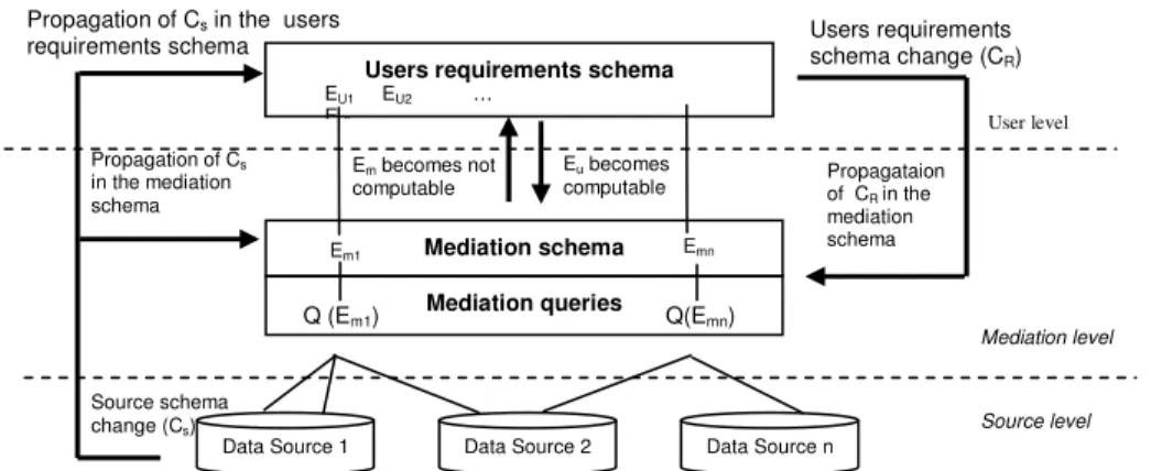
3.4 MEDIATION QUERIES... 36
3.4.1 Mediation Queries Definition ... 36
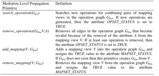
3.4.2 Mediation Queries Evolution ... 38
3.4.2 Summary ... 41
3.5 QUERY REFORMULATION... 42
3.5.1 The Query Reformulation Process ... 42
3.5.1 Summary ... 43
3.6 QUALITY OF THE INTEGRATED SCHEMA... 44
3.6.1 Miminality ... 45
3.6.2 Schema IQ Improvement... 47
xii 3.7 MAIN RESULTS... 49 3.7.1 Integra Prototype... 49 3.7.2 PhD and MSc Theses ... 50 3.7.3 Publications ... 51 3.8 REFERENCES... 52 SEMANTIC ISSUES IN PDMS ... 55 4.1 INTRODUCTION... 55 4.2 SEMANTIC ISSUES... 56 4.2.1 Ontologies... 56 4.2.2 Context ... 56 4.2.2 Summary ... 57
4.3 CONTEXT-ORIENTED MODEL... 57
4.3.1. Generic Context Management Concepts Specification ... 58
4.3.2 Context Management ... 60
4.3.3 Summary ... 60
4.4 SEMANTICS IN DATA INTEGRATION... 61
4.4.1 Context in Data Integration... 61
4.4.2 A Contextual Ontology for Data Integration ... 62
4.4.3 Summary ... 63
4.5 A SEMANTIC APPROACH TO DATA MANAGEMENT IN PDMS... 64
4.5.1 PDMS and Ontologies ... 64
4.5.2 PDMS Architecture... 65
4.5.3 SPEED Community and Clusters ... 66
4.5.4 Summary ... 67 4.6 MAIN RESULTS... 67 4.6.1 PhD and MSc Theses ... 67 4.6.2 Publications ... 68 4.7 REFERENCES... 69 OTHER ACTIVITIES ... 71 5.1 RESEARCH ACTIVITIES... 71 5.2 ADDITIONAL ACTIVITIES... 72 5.3 MAIN RESULTS... 72 5.3.1 PhD and MSc Theses ... 72 5.3.2 Publications ... 73
CONCLUSION AND PERSPECTIVES ... 75
6.1 SUMMARY... 75
6.2 FUTURE TRENDS... 75
6.2.1 Open Issues in Data Integration Environments... 75
6.2.2 Semantic Peer Data Management ... 76
6.2.3 Semantics and Quality ... 77
6.3 CONCLUSION... 77
ANNEXE 1 ... 79
1
Foreword
Since my PhD studies I was interested in solutions for the emerging applications. My first interest was Multimedia Databases and the proposal of an object-oriented physical objects’ manager as the kernel of a multimedia DBMS. Then, when I joined the UFPE database group I had worked in this research area in which the main contributions were a data type manager and an extension to the relational model. These researches were done within the following projects:
o Implementing a Multimedia Database based on an Extension of the Relational Model,
o Data management and Application for Multimedia Databases: The Case of Spatial Data
The growth of Geographical Information Systems, and the need to properly store and access spatial data, had motivated a large investigation to understand and propose solutions to geographical modeling and implementation problems. In this sense, the main contributions were an object-oriented approach to modelling geographic applications, a performance analysis of multidimensional access methods and a visual query language. The following projects allowed these researches:
o Modeling and Implementation of Geographical Databases o Geotec - Geoinformatics: Methods and Techniques
o Distributed Geographical Databases and their Applications on the World Wide Web
The emergence of the Web have caused a huge interest on how to integrate heterogeneous and distributed data sources (databases and other structured or semi-structured documents). I have worked on data integration issues since then. The proposal of a mediator-based system architecture, an approach to mediation query evolution and a query reformulation process has lead to the implementation of a data integration system prototype, in the context of the project:
o Information Integration in Heterogeneous Environment: Architectures, Models and Implementations
The new distributed architecture (P2P and GRID) and the Semantic Web associated issues are our current research focus. I am currently working on evolution and quality issues of data integration systems, and also on semantic approaches applied to Peer Data Management Systems (PDMS), in these ongoing projects:
o GridVida: Unified View of Electronic Patient Records in Grid Computing o SPEED: Semantic Peer-to-Peer Data Management System
o Evolution and Quality Management in Dynamic Data Integration Systems, International cooperation research project with partners in France, Uruguay and Brazil In addition, I have also worked in other research areas such as Information Retrieval, Cooperative Systems, Cooperative Learning and Autonomous Databases with some other results. All the research projects had financial support of Brazilian institutions, two of them in the context of an international cooperation.
To summarize, in all these projects I supervised six concluded PhD theses, four others ongoing, and 31 MSc theses, with three ongoing. All the concluded PhD are associate professors in Brazilian universities. It is very important to say that I would not be able to accomplish the results presented in this report without the contribution of all the students (graduate and under-graduated) I supervised.
This report presents the research done since 1989. It is important to notice that the state of the art of each research area is not of nowadays but related to the respective period of time.
3
CHAPTER 1
Introduction
1.1 Historical Retrospective
In the late 1970’s and early 1980’s, when the concept of abstract data types were included in some programming languages and when personal computers emerged, the information systems’ application domains was extended allowing the implementation of the so called non-conventional applications (medicine, geographical, office automation, CAD, among others). These new applications demand the use of specific data types (graphics, audio, images and others), characterizing the multimedia applications. At this time, the database community had identified limitations on the relational model, mainly to represent complex objects, and there were a large number of proposals to extend the basic relational model. In parallel, the success of object-oriented programming languages had caused the emergence of a new paradigm of database modeling and implementation, and a large number of object-oriented Database Management Systems (DBMS) prototypes appeared (O2, Orion, ObjectStore, among others).
The era of the internet in the 1990’s changed the way information systems were implemented. First of all, the need to represent (HTML) and to search (search engines) the huge amount of non structured data spread in the Web. The second phase was to include more structure and semantics (XML) in the representation of Web data, and afterwards to integrate semi-structured and semi-structured data stored on distributed, heterogeneous and autonomous data sources. Recently, Peer Data Management Systems (PDMS) came into the focus of research as a natural extension to distributed databases in the peer-to-peer (P2P) context [Herschel & Heese 2005]. PDMS are P2P applications where each peer represents an autonomous data source and exports its entire data schema or only a portion of it.
The increasing use of the Web has caused a permanent growth in the amount of data available on it. Efforts to overcome the obstacles created by this ample growth, associated with the desire of inserting some level of intelligence to the retrieval of documents disposed in the Web, have motivated the development of the new generation of the Web: the Semantic Web [Berners-Lee et al. 2001].
The rest of this chapter will present the main issues that motivated our research interests. First of all, the Multimedia Databases, especially the Geographical Databases and the problems related to spatial data modeling and implementation, which are discussed in Section 1.2. The emergence of the Web and its growth are discussed in Section 1.3. The concepts associated to the Semantic Web, and the need to integrate multi-source data (databases or other structured or semi-structured documents) are presented in Section 1.4. Finally, in Section 1.5 we present the structure of this report.
4
1.2 Multimedia Databases
The diversity of information systems application domains caused the need to represent complex data types (graphics, video, image, audio, text, among others) [Grosky 1994]. The programming languages in a first moment, and the DBMS later, provided functionalities to include new data types according to the application to be implemented. These multimedia data types are characterized by a huge volume and have some requirements, which have implications on their storage, manipulation, and presentation (with appropriate interfaces). A multimedia database management system must provide a suitable environment for using and managing the multimedia data [Woelk & Kim 1987]. The geographical databases are a special case of multimedia databases in the sense that they manipulate non standard data types (point, line, polygon, cells or tessellations). Spatial data are complex, voluminous and need a specific set of operators.
We were mainly interested in modeling and implementation issues of geographical databases. In this sense, we have proposed an object-oriented modeling approach to spatial data (objects and fields) [Times 1994, Pimentel 1995]. A partial implementation of this approach was done using the Postgres [Stonebraker & Rowe 1986] DBMS. The Postgres existing spatial data types were extended with new types according to the proposed model, and a query language was implemented as an extension of POSTQUEL query language [Nascimento 1995].
The management of the spatial data objects is more complex than the handling of conventional data made by traditional DBMS. This complexity issue arises as new data types are needed to describe the geometry of spatial data objects from coordinate data. To deal with this problem, DBMS were extended to include more efficient data structures and special search algorithms, known as multidimensional access methods (MAM) [Gaede & Günther 1998]. These methods have been designed for providing an optimum access path to spatial data. Nevertheless, with the great amount and diversity of proposed MAM, there was a need for comparing the efficiency of several proposals supporting both distinct data configurations and many query types. For this purpose, we have analyzed a group of multidimensional access methods (called the R-tree group) in terms of the spatial data distribution using the experimental technique of database benchmark [Ciferri 2002].
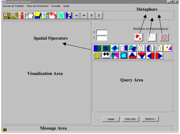
User interfaces for GIS require considerable research and technology development efforts for usability enhancement [Wessel & Haarslev 1998]. An important aspect of usability in this context is the need for a visual query language to enable users to think graphically, while building queries. In this sense, we have proposed a geographical visual query language, GeoVisualQL [Soares 2002], and its respective user interface, GeoVisual Interface [Souza 2000].
1.3 The Web
The original efforts to develop the Web as it is known today were done in the beginning of the 1990’s [Berners-Lee et al. 2001]. Such efforts however, were fully rewarded, once the Web had been consolidated as the mean of information distribution with the faster growth in the worldwide history. On the other hand, the increasing use of the Web has caused a permanent growth in the amount of data available. This fast expansion made the Web a data repository as huge as confused. Its specific characteristics have generated a crescent demand for tools specialized in performing efficient management and qualified data retrieval/extraction from Web contents [Baeza-Yates & Ribeiro-Neto 1999].
The standard language used to create Web pages, the HTML (Hypertext Markup Language) [Ragget 2005] does not specify any semantics related to the resource it formats, being responsible just for the appearance of the Web document. Thus, a gap emerges between the information that is available to Web services and the one that is provided for human reading.
5
Search engines were the first attempt to access Web content but it mainly deals with unstructured data [Baeza-Yates & Ribeiro-Neto 1999]. These classes of software mechanisms are both guided by searches based on the meaning of the keywords provided by its users or contained in the text. These tools do not consider the semantic aspects involved in the keywords that were submitted to the search, analyzing the word just syntactically. A complementary research area is the Information Extraction [Adams 2004]. Its main objective is to extract relevant information from semi-structured documents, and present the information extracted in a user friendly format.
The lack of meaning in HTML documents makes hard to software agents processing these types of documents in an intelligent way, being necessary to develop a way that allows us to insert some “intelligence” in the Web resources. XML includes some semantics on documents through the definition of significant tags [Bray et al. 2006]. XML allows the representation of semi-structured data.
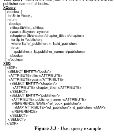
Integrated access to multiple data sources ranging from traditional databases to semi-structured data repositories was required in many applications. In the last decade, the problem of integrating data from distributed, heterogeneous and autonomous data sources has received a great deal of attention. It consists in providing a uniform view of these data sources in which the users can pose their queries. We have proposed and implemented Integra, a prototype of a mediator-based data integration system. Integra adopts the Global-as-View (GAV) approach [Halevy 2000] to define mappings between the integrated mediation schema and the data source schemas. Our main contributions were associated to the specification and implementation of two important processes: (i) the definition and evolution of mediation queries when data source schemas change [Loscio 2003], and (ii) the query reformulation process [Costa 2005]. Recently, we have been working in the definition and evaluation of schema quality criteria for the generated mediation schema [Batista 2008].
1.4 The Semantic Web
The Semantic Web can be thought as an extension of the current Web, where data gains its own meaning. The main objective of this new Web paradigm is to insert some level of knowledge into WWW resources, so that software agents can be able to intelligently process Web contents [Hendler 2001]. According to [Shadbolt et al. 2001], agents can only flourish when standards were well established and the web standards for expressing shared meaning have progressed steadily over the last years.
A multi-layer architecture has been proposed by Tim Berners Lee [Berners-Lee et al. 2001, Studer 2003] to support the Semantic Web. Amongst these layers, we would like to highlight the Ontology vocabulary. The specification of an ontology makes possible the communication between computer systems, independently of the architecture and the information domain treated, eliminating ambiguities over a domain terminology [Bézivin 1998, Cardoso 2007]. So, we can say that an ontology provides a common/shared understanding about concepts of specific knowledge domains.
Data integration fits in the Semantic Web scenario which demands for complete application interoperability. To include more semantic issues in Integra, we have been working on a semantic name resolution process to the mediation schema generation process [Belian 2008]. This process uses syntactic methods to match element names against terms of a domain ontology, and uses contextual information to reduce the range of similar terms obtained in the linguistic match. In this case, the contextual information provides knowledge about data source schemas and element names (terms) with this purpose. The contextual information used in this work is represented by a context ontology enabling information reusability and sharing, besides reasoning capability.
6
1.5 Intensive Access to Remote Data
Nowadays, we see the growth of remote heterogeneous data all over the Web and the coming of new distributed architectures to facilitate the access to these data. Peer-to-Peer (P2P) is one of these new architectures used mainly for file sharing and, more recently, for structured data sharing. Data management in P2P systems is a challenging and difficult problem considering the extreme number of peers, their autonomous nature and the potential heterogeneity of their schemas [Halevy et al. 2006]. A Peer Data Management System (PDMS) is one such application which enables users to transparently query several heterogeneous and autonomous data sources. A PDMS is considered an evolution of the traditional data integration systems [Sung et al. 2005]. As data integration systems, PDMSs realize their services over data from existing heterogeneous sources and, in order to reconcile heterogeneity, more semantic information about the data sources is needed. In this sense, Web Semantic issues such as metadata, contexts and ontologies are used to solve semantic conflicts among information from diverse heterogeneous web data sources [Kashyap & Sheth 1996].
We are currently working on the specification of SPEED (Semantic PEEr-to-Peer Data Management System) an ontology-based PDMS in which the content shared by peers (exported schema) is represented through ontologies. The system adopts a mixed network topology (DHT and super-peer) in order to exploit the strengths of both topologies. A DHT network is used to assist peers with common interests to find each other and form semantic communities. Within a community, peers are a grouped in clusters of semantically related peers. We are addressing two main issues: the formation and maintenance of clusters [Pires 2009] and the query rewriting among peers that are semantic neighbors using contextual information [Souza 2009].
Context is what underlies the ability to differentiate one situation from another and to characterize entities and events. The concept of context is been used in several domains, and mainly in context-aware ubiquitous applications. Most context-sensitive systems do not take into account requirements such as modularity, reusability or interoperability and implement context manipulation tasks in a proprietary way, so as to fulfill the particular needs of each system. Context management aims at providing solutions to separate context manipulation tasks from applications’ business. We are also currently working on the specification and implementation of a domain-independent context manager based on the Context-Oriented Model [Vieira 2008]. The main idea is to provide a general framework to context-aware application developers.
1.6 Report Structure
This report will focus on three main research areas that we talked about in previous sections: Geographical Databases, Data integration and Semantic Issues in PDMS. In this sense, it includes the following content:
o Chapter 2 – Geographical Databases, where we discuss the several issues we had been working on Geographical Databases along with our main contributions in the area.
o Chapter 3 – Data Integration, which contains our proposal to a data integration system, its characteristics and processes.
o Chapter 4 – Semantic Issues in PDMS, where we discuss some semantic issues and the use of semantic-based techniques in a PDMS proposal.
o Chapter 5 – Other Activities, where we briefly present some other research areas we have been working on.
o Chapter 6 – Conclusion and Perspectives, which summarize the main issues discussed in this report and presents some perspectives for future works.
7
o Annexe 1, which contains a summary of the main collaborative projects we have participate o Annexe 2, which presents a quantitative summary of the results obtained by research area.
1.6 References
[Adams 2004] Adams, K.C. The Web as Database: New Extraction Technologies and Content Management, ONLINE: Exploring Technology & Resources for Information, Vol.25, N.2, 2001 (also available at http://www.onlinemag.net/OL2001/adams3_01.html, last access March 2008) [Baeza-Yates & Ribeiro-Neto 1999] Baeza-Yates, R., Ribeiro-Neto, B. Modern Information Retrieval. ACM Press, Nova York, 1999
[Batista 2008] Maria da Conceição Moraes Batista. Schema Data Quality on Information Integration Systems, PhD Thesis, Center for Informatics – UFPE, 2008 (ongoing)
[Belian 2008] Rosalie Barreto Belian. A Context-based Name Resolution Process for Schema Integration, PhD, 2008
[Berners-Lee et al. 2001] Berners-Lee, T., Hendler, J., Lassila, O. The Semantic Web, Scientific American, Vol.284, N.5, 2001, p. 34–43.
[Bézivin 1998] Bézivin, J. Who´s Afraid of Ontologies. In Proc. of the Model Engineering, Methods and Tools Integration with CDIF Workshop (OOPSLA’98), Vancouver, Canada, 1998 [Bray et al. 2006] Bray, T., Paoli, J., Sperberg-McQueen, C.M, Maler, E., Yergeau, F. Extensible
Markup Language (XML) 1.0 (Fourth Ed.), W3C, 2006 (available on
http://www.w3.org/TR/REC-xml, last access February 2008)
[Cardoso 2007] Cardoso, J: The Semantic Web Vision: Where are We?, IEEE Intelligent Systems, Vol. 22, No. 5, 2007, p. 84-88.
[Ciferri 2002] Ricardo Rodrigues Ciferri. Analysing the Performance Variation of Multidimensional Access Methods in Terms of Spatial Data Distribution, PhD Thesis, Center for Informatics – UFPE, 2002
[Costa 2005] Thiago Alves Costa. Gerenciamento de Consultas em um Sistema de Integração de Dados, MSc Thesis, Center for Informatics – UFPE, 2005
[Gaede & Günther 1998] Gaede, V., Günther, O. Multidimensional Access Methods, ACM Computing Surveys, Vol.30, N.2, 1998, p. 170-231
[Grosky 1994] Grosky, W.I. Multimedia Information Systems, IEEE Multimedia, Vol.1, N.1, 1994, p. 47-59
[Halevy 2000] Halevy, A., Y.: Logic-based Techniques in Data Integration. J. Minker, editor Logic based Artificial Intelligence, Kluwer Publishers, 2000
[Halevy et al. 2006] Halevy A., Rajaraman A., Ordille J. Data Integration: The Teenage Years, In Proc. of the 32nd International Conference on Very Large Data Bases (VLDB), Seoul, Korea, 2006, p. 9-16
[Hendler 2001] Hendler, J. Agents and the Semantic Web, IEEE Intelligent Systems, Vol.16, N.2, 2001, p. 30-37.
[Herschel & Heese 2005] Herschel, S., Heese, R. 2005. Humboldt Discoverer: A Semantic P2P index for PDMS. In Proc. of the International Workshop Data Integration and the Semantic Web (DisWeb), Porto, Portugal, 2005
[Kashyap & Sheth 1996] Kashyap, V., Sheth, A.P. Semantic and Schematic Similarities Between Database Objects: A Context-Based Approach, VLDB Journal, Vol.5, N.4, 1996, p. 276-304 [Loscio 2003] Bernadette Farias Lóscio. Managing the Evolution of XML-based Mediation Queries, PhD Thesis, Center for Informatics – UFPE, 2003
8
[Nascimento 1995] Adriana Maria Rebouças do Nascimento. LinGeo - Uma Linguagem de Consulta Geográfica, MSc Thesis, Center for Informatics – UFPE, 1995
[Pimentel 1995] Flávio Leal Pimentel. Uma Proposta de Modelagem Conceitual Para Dados Geográficos - Modelo MGeo+, MSc Thesis, Center for Informatics – UFPE, 1995
[Pires 2009] Carlos Eduardo Santos Pires. Semantic-based Approach for Peer Clustering in a Peer Data Management System, PhD Thesis, Center for Informatics – UFPE, 2009 (ongoing)
[Raggett 2005] Raggett, D. Getting Started with HTML, W3C, 2005 (available on http://www.w3.org/MarkUp/Guide/, last access February 2008).
[Shadbolt et al. 2006] Shadbolt N., Berners-Lee T., Hall W. The Semantic Web Revisited, IEEE Intelligent Systems, Vol.21, N.3, 2006, p.96-101.
[Soares 2002] Valéria Gonçalves Soares. GeoVisual – A Visual Query Environment for Geographical Databases, PhD Thesis, Center for Informatics – UFPE, 2002
[Souza 2000] Damires Yluska de Souza Fernandes. GeoVisual Interface - Uma Interface para Consultas Visuais em Banco de Dados Geográficos, MSc Thesis, Center for Informatics – UFPE, 2000
[Souza 2009] Damires Yluska de Souza Fernandes. Semantic-based Query Reformulation for PDMS, PhD Thesis, Center for Informatics – UFPE, 2009 (ongoing)
[Stonebraker & Rowe 1986] Stonebraker, M., Rowe, L.A. The Design of POSTGRES, In Proc. of the ACM SIGMOD International Conference on Management of Data, Washington, USA, 1986, p. 340-355
[Studer 2003] Studer, R., Agarwal S., Volz, R. The Semantic Web Methods, Applications and Future Trends, In Proc. of the 3rd
IFIP Conference on Commerce, Business, and e-Government, Guaruja, Brasil, 2003, p.203-213
[Sung et al. 2005] Sung, L.G.A., Ahmed, N., Blanco, R., Li, H., Soliman, M.A., Hadaller, D.A. Survey of Data Management in Peer-to-Peer Systems, School of Computer Science, University of Waterloo, Canada, 2005
[Times 1994] Valéria Cesario Times, V. MGeo: An Object-oriented Model for Geographical Applications, MSc Thesis, Center for Informatics – UFPE, 1994
[Vieira 2008] Vaninha Vieira dos Santos. A Domain Independent Approach for Managing Contextual Elements, PhD Thesis, Center for Informatics – UFPE , 2008 (ongoing)
[Wessel & Haarslev 1998] Wessel, M. Haarslev, V.VISCO: Bringing Visual Spatial
Querying to Reality, In Proc. of the IEEE Symposium on Visual Languages, Halifax, Canada,
1998, p.170-177
[Woelk & Kim 1987] Woelk, D., Kim, W., Multimedia Information Management in an Object-Oriented Database System, In Proc. of the International Conference on Very Large Data Bases (VLDB), Brighton, England ,1987, p. 319-329
9
CHAPTER 2
Geographical Databases
2.1 Introduction
A Geographic Information System (GIS) is “a powerful set of tools for collecting, storing, retrieving at will, transforming and displaying spatial data from a particular set of purposes” [Burrough & McDonnell 1998]. Geographical data represent phenomena from the real world in terms of their position in coordinate systems, their attributes and their spatial interrelations with each other.
A Geographical Database is a collection of inter-related and geo-referenced data. By definition, it is a database directed to the representation, storage and access to the information, which is spatially referenced. It must also provide the user with the capacity to: work with several and different data types, get all the relevant information in a consistent way, and access a toolkit of sophisticated analysis.
Geographical Data Modeling consists in the formulation of an adequate set of abstractions to represent the geographical reality in the database, and in the definition of data handling conditions and integrity rules.
Traditional techniques of data modeling were not adequate for the treatment of geographical data [Orenstein & Manola 1988, Ooi et al. 1989, Egenhofer 1993, Gardarin 1993]. The difficulty consists of the fact that most of these data are validated in terms of its spatial localization, time, and the reliability of the collection [Roberts et al. 1991]. According to Peuquet [Peuquet 1984], multidimensionality, large number of relationships and complex spatial definitions make the modeling of geographical data uniquely difficult. The models themselves tend to be complex and the resultant data files tend to be not very compact. The problem of a lack of uniformity to deal with geographical data was due in large part to the several differences in the commonly used storage formats. Basically, this was also due to a lack of fundamental knowledge concerning properties of spatial data and concerning the design and evaluation of spatial data models.
Geographical databases cover a very large range of applications problems. For this reason, some geographical models are directed to a specific application area [Lapalme et al. 1992, Williamson & Stucky 1992] or for the sake of simplicity they are exclusively designed to deal with operations belonging to raster or vector format. Object-oriented data models have facilities to express more suitably the knowledge domain of several geographical applications [Oosterom & Bos 1989, Dueker & Kjerne 1987, Egenhofer & Frank 1987] due to the spatial nature of their data and operators. An object model for a geographical database has spatially referenced objects as its constituents.
10
In what follows, we present the object-oriented geographic data model MGeo+ and its query language LinGeo. We also present some results concerning spatial access methods’ analysis and a proposal we had made on a visual query language for geographical data along with its user interface.
This research had financial support (four projects) from a Brazilian institution (CNPq) from 1991 to 2003.
2.2 Spatial Data Modeling
Spatial data models are grouped into three categories. The first one is raster (continuous space) which represents the distribution of physical entities dividing space into cells with the same format and size, each cell being associated with only one value of the physical variable being represented. The second is vector (discrete objects) which divides the space into spatial objects with symbols, descriptive attributes, and coordinates associated with themselves, and each spatial object corresponds to an element of the actual world. The last one is the hybrid approach which incorporates aspects of both formats described above.
In this sense, the rest of this section presents a hybrid conceptual data model and its associated query language.
2.2.1 The MGeo Conceptual Data Model
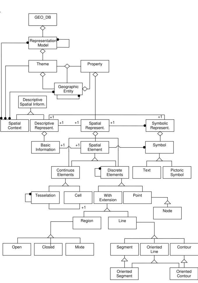
We have disigned an object-oriented data model for geographical applications, called MGeo, which allows the modeling of spatial objects (discrete elements) [Times 1994]. Afterwards, this model was extended allowing the representation of continuous elements, generating the MGeo+ version [Pimentel 1995]. In order to formalize the main elements of this model we used the OMT methodology [Rumbaugh et al. 1991]. The structure of a geographical database is shown in Figure 2.1, where relationships among the classes of the data model are illustrated. In what follows we will briefly describe the MGeo+ classes’ hierarchy and the defined spatial operators. Classes’ Hierarchy
GEO_DB constitutes from a more generic point of view a set of geographical data. The next most important and more generic class of the hierarchy is REPRESENTATION MODEL. This class represents an aggregation of thematic layers (THEME). Each THEME is composed by GEOGRAPHIC ENTITIES and their properties and each PROPERTY can be represented through DESCRIPTIVE, SPATIAL and SYMBOLIC REPRESENTATION. This relationship allows real world objects (e.g. cities, rivers or roads) to have more than one spatial and symbolic representation. In this way, a single object which can be represented in different scales or projections will have associated with it a level of descriptive information, a geometry and a symbology in adequate proportions.
A spatial representation is an aggregation of SPATIAL ELEMENTS and each one can have a raster format (CONTINUOS ELEMENTS), represented by CELLs and TESSELATION, or a vector format (DISCRETE ELEMENTS), represented by POINT, LINE and REGION, and their sub-elements.
As an example of a MGeo+ class definition let consider the REGION class: REGION CLASS
The instances of this class represent the bi-dimensional spatial objects. They are defined by a sequence of lines which delimitate a region. The following operators are defined for the Region Class:
11 .
Figure 2.1 – MGeo Class Diagram GEO_DB Representation Model Theme Property Geographic Entity Descriptive Spatial Inform. Descriptive Represent. Spatial Represent. Symbolic Represent. Spatial Context Basic Information Spatial Element Symbol Continuos Elements Discrete Elements Text Pictoric Symbol With Extension Point Tesselation Cell Region Line Node Closed Mixte
Open Segment Oriented
Line Contour Oriented Segment Oriented Contour +1 +1 +1 +1 +1 +1 +1 +1
12 Area: calculate the area of a specific region.
Interior: return the interior of a specific region.
Component: return the topological components, which are the connected and maximum sub-regions, of a specific region.
Boundary: return the set of points which belong to the boundary of the region. A region can have negative sub-regions. These sub-regions are internal areas of the region which are not considered by the domain of the problem being modeled at the moment. A terrain containing a lake or a region with a number of disjoint islands, which are not important to the application, can be modeled in this way. A region can also be OPEN, where its boundary is not considered; CLOSED, where its boundary is quite considered; and MIXED, where its boundary is partially considered.
Spatial Operations
Spatial operators have been defined related to spatial object classes. They are classified into three groups:
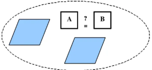
• Set-oriented - operators that deal with objects as set of objects: Equal, Subset, Membership, Union, Intersection, Difference, Cardinality, Complements, Elements, Windowing, Disjoint, Parts, Lines, Joint.
• Topological - ideal with topological properties, such as localization, adjacency and connectivity, of spatial objects: Interior, Extremes, Begin, End, Clockwise, In, Closure, Boundary, IsConnected, Connect, IsTherePath, Path, Adjacent, Component, IsBoundary
• Metric - deal with metric properties of space in which objects are defined. This group also includes notions of the Euclidian Metric: Distance, Length, Parameters, Direction, Area
The complete specification of all classes of MGeo+ data model, including operations, can be found in [Times 1994, Pimentel 1995].
2.2.2 LinGeo – A Geographical Query Language
A spatial query language must allow the manipulation and access to spatial and non spatial data. In our approach we only considered vector data: point, line and polygon. Several types of spatial query languages were proposed: based on the graphical representation as MapQuery [Frank 1982], GEOQL [Sacks-Davis et al. 1987, Ooi et al. 1989], Pictorial SQL [Roussopoulos & Leifker 1985] and Spatial SQL [Egenhofer 1994], based on QBE (Query-by-Example): QPE [Chang & Fu 1980] and PICQUERY [Joseph & Cardenas 1988]; and based on Quel: POSTQUEL [Stonebraker & Rowe 1986] and Geo-QUEL [Berman & Stonebraker 1977].
We have proposed LinGeo [Nascimento 1995] whose objective was to define and manipulate spatial objects as stated by MGeo+. One of its main characteristics was the extensibility, i.e., to allow de definition of new data types, operators and functions. LinGeo was implemented as an extension of the spatial data types proposed by PostGres [Stonebraker & Rowe 1986] (point, lseg, line and polygon) with new data types: cont (contour), cont_or (oriented contour), line_or (oriented line) and lseg_or (oriented line segment). Some of the MGeo+ spatial
operators were also implemented extending POSTQUEL.
LinGeo was created to facilitate the management of geographical data allowing the creation and deletion of spatial classes; the update, inclusion, exclusion and querying of geographical data; the manipulation of spatial and non spatial data in a similar way; and the offer of geographical operators.
13
2.2.3 Summary
The proposed MGeo+ modeling approach was the base of several works that have been developed in our database group, and also in cooperation projects with other institutions. It was completely formalized using MooZ (Modular Object-Oriented Z) [Meira & Cavalcanti 1992]. MooZ is a language that enriches the formal language Z [Bowen 1992] with object-oriented concepts and whose semantics is based on set theory and first-order logic. The MGeo+ and its LinGeo language were part of three MSc theses [Times 1994, Times & Salgado 1994, Pimentel 1995, Nascimento 1995, Nascimento & Salgado 1995]
The master student that proposed MGeo first version has continued her PhD studies in Leeds, England, and is currently the leader of the geographical database researches at UFPE. We are both supervising a PhD thesis that proposes a query language to integrate geographical and analytical (OLAP) operators [Silva 2008].
2.3 Performance Analysis of Spatial Access Methods
Spatial Database Management Systems (SDBMS) extend the typical functionalities used for the management of alphanumeric data in secondary memory by integrating and supporting spatial data types (e.g. points, lines, polygons and three-dimensional solids), in their data model, query language and physical implementation [Güting 1994]. However, the query processing performance of these systems has strongly been influenced and improved through the use of more efficient data structures and special search algorithms, known as multidimensional access methods (MAM) [Gaede & Günther 1998]. These methods have been designed for providing an optimum access path to spatial data which is based on a well-defined set of predicates. In this sense, the indexed space is organized in such a way that allows the retrieval of spatial data objects that are located close to each other. For example, the execution of queries about spatial objects contained in a certain area just requests the access to objects located close to this area, as opposed to the analysis of the whole set of objects stored in the disk.Several factors influence MAM performance, which can be associated with the data, the workload, the tuning parameters of the data structure and the buffer-pool management. These factors are called decisive performance factors. Among these, the spatial data distribution is one of the factors that strongly affect MAM performance as it directly affects the way most access methods partition space. In other words, it influences the formation of areas that divide space and, therefore, it affects the data clustering task of an access method and might degenerate its internal organization.
This work investigated the performance variation of a certain group of multidimensional access methods (called the R-tree group) in terms of the spatial data distribution. By evaluating the efficiency of these access methods concerning 21 different datasets, we verify how the spatial data distribution affects the costs of both inserting new entries in the data structure and making spatial query selections. In order to appropriately run the performance tests, we devised a methodology that allows the generation of a set of data distributions with various characteristics. This set enabled us to analyze the spatial data distribution factor from distinct perspectives.
The next subsections present the main characteristics of the workbench, as well as some aspects of the R-tree access methods that were considered in our work, and the performance results obtained from our study.
14
2.3.1 Experimental Setup
The performance tests were executed on Sun SparcStation 4 workstations under the operating system UNIX, having 320 Mbytes of RAM memory and 4.5 Gbytes of disk. In order to be able to compare our work with the performance results reported by other researchers, especially by Cox [Cox 1991] and Carneiro [Carneiro & Magalhães 1998], our performance results were measured according to the number of disk accesses (i.e. number of disk pages accessed during the execution of insertion operations and spatial queries). This measure particularly aimed to avoid the collateral effects caused by the concurrent execution of several programs and applications of a multi-user and multi-programming environment which is an aspect inherent to our testing environment. This also allowed us to determine the costs of data I/O from/to disk, which is in turn the main part of the costs involved in the execution of most of the spatial selection queries.
2.3.2 Multidimensional Access Methods Addressed
The investigated multidimensional access methods, called the R-tree group, consist of the following methods: R-tree with quadratic-cost split algorithm [Guttman 1984], the R+-tree [Sellis et al. 1987] and three variants of the R*-tree. The first variant of the R*-tree is an extension of the original work, as reported in Beckmann. [Beckmann et al. 1990]. This extension uses a routine for reinsertion of entries during the operation of data insertion, when the first overflow treatment occurs in a certain hierarchical level of the tree (forced reinsert). According to the original work, the process of reinsertion of entries employs the close reinsert technique. This technique asserts that among p chosen entries (i.e. entries having MBB with the most distant centers from the center of the MBB of the node), the reinsertion is made from the less distant entry to the most distant one. The second variant, called by Carneiro [Carneiro & Magalhães 1998] R*-treeFR, uses the reinsertion of entries according to the far reinsert technique (i.e. from the most distant entry to the less distant one). Finally, the third variant of the R*-tree, called R*-treeSR, does not use reinsertion of entries in the insertion routine.
A detailed description about the structure of these multidimensional access methods can be obtained from the references listed above and from the survey conducted by Gaede and Günther [Gaede & Günther 1998]. However, it is important to discuss the possible values that the tuning parameters of the MAM data structures can take. These parameters affect the efficiency of the insertion operations and spatial queries, as acknowledged in [Kriegel et al. 1989], and they are: (i) m (i.e. minimum allowed number of entries per node or disk page) and (ii) p (number of entries to be reinserted in the overflow treatment). The goals of using the parameter m are to guarantee a minimum node occupation and consequently, to minimize storage costs. For this parameter, we used 40% of the maximum number of entries per node, for almost all access methods, except for the R+-tree. For the R+-tree, the value of m is equal to one. For the parameter p, which is specifically valid for the variants of the R*-tree, we used 30% of the maximum number of entries per node [Beckmann et al. 1990].
2.3.3 Further Characteristics of the Performance Tests
The buffer-pool consisted of a set of 20 disk pages of 4 Kbytes stored in main memory and aims to minimize the number of disk accesses. The buffer-pool management was made according to the LRU policy (least recently used) for disk page replacement. In our workbench, the access methods or any other programs did not share the buffer-pool. For the R-tree and the three variants
of the R*-tree access methods, the 4K size for a disk page allowed a maximum number of 102
15
node. For the R+-tree, the maximum number of entries is smaller than the others due to the storage of two rectangles for its entries: these are the MBB and the MaxRect.
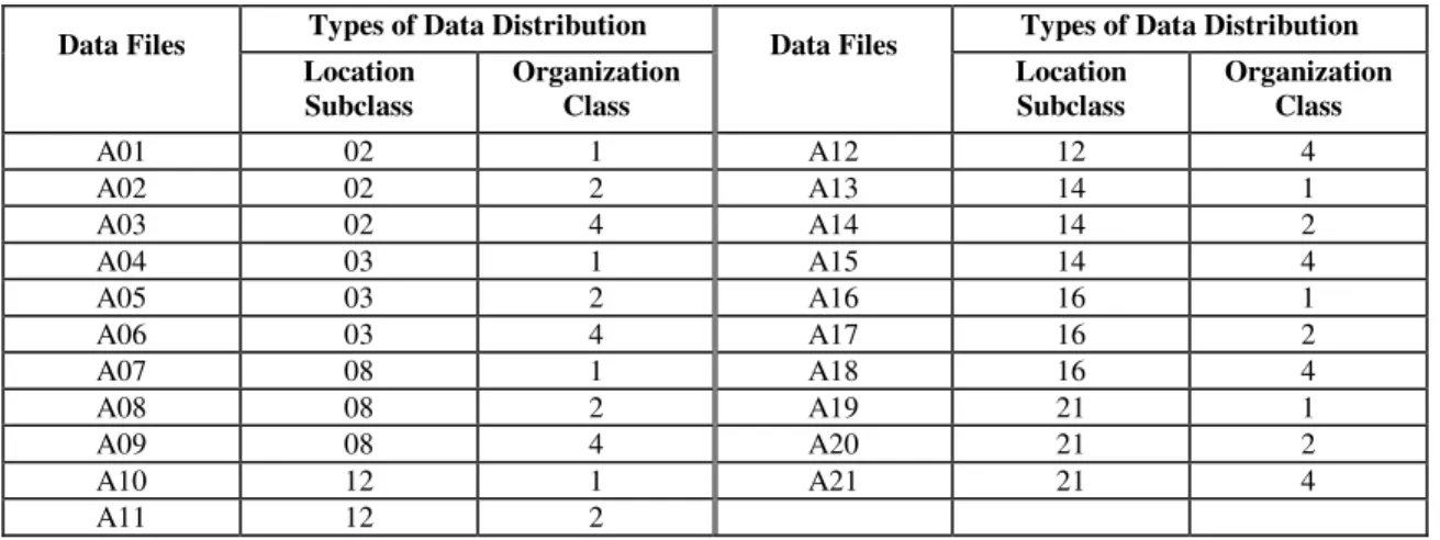
The data used in the performance tests were composed by rectangles occupying 0.1% of the total area of the extent in size and linear in shape. This shape varied uniformly according to the following parameters: (i) linear-x, which specifies that the extension in dimension x is twice larger than the extension in dimension y, and (ii) linear-y, which determines that the extension in dimension y is twice larger than the extension in the other dimension x. Each data file was composed by 10,000 rectangles that had artificially been generated according to the characteristics mentioned above. Also, they were located inside of an extent limited to the unitcube [0,1)2, and their spatial distribution was obtained by using the proposed methodology. This methodology allows the generation of a set of 126 types of data distribution which results from the combination of location subclasses (collective location of the data) and organization classes (data organization). The points related to the distribution are generated according to the chosen organization class that falls within the limits specified by the location subclass, as shown in Figure 2.2. In particular, these distribution types have different characteristics which enable analyzing the consequences of spatial data distribution under distinct perspectives. These perspectives range from a weak to a strong influence on the performance of MAM. However, only a subset of the possible types of data distribution that can be generated using this methodology was initially considered in our investigation. These are shown in Table 1.
Figure 2.2 - Examples of the Fourth Organization Class
In the total, 21 types of data distribution related to the subclasses of location 2, 3, 8, 12, 14, 16 and 21, and to the first, second and fourth organization classes were considered in our experiments. In choosing the location subclasses, we selected a representative for at least a subclass of each location class, as well as we reproduced some distribution types that had been analyzed in related works.
Table 1 - Data Files and their respective Spatial Data Distributions
Types of Data Distribution Types of Data Distribution Data Files Location Subclass Organization Class Data Files Location Subclass Organization Class A01 02 1 A12 12 4 A02 02 2 A13 14 1 A03 02 4 A14 14 2 A04 03 1 A15 14 4 A05 03 2 A16 16 1 A06 03 4 A17 16 2 A07 08 1 A18 16 4 A08 08 2 A19 21 1 A09 08 4 A20 21 2 A10 12 1 A21 21 4 A11 12 2 Subclass 15 Subclass 14
16
After generating the data files, for each access method, the performance tests were made by building the indexing structure associated with each one of these files. To achieve this goal, successive insertion operations of new entries were applied to the data structure from an empty tree. Following this, we ran some types of spatial selection queries, such as point query, intersection range query and enclosure range query1. These three query types were independently executed, for each multidimensional access method and dataset investigated in our analysis. To control the execution of queries, a strategy based on four types of query files (i.e. Q1, Q2, Q3 and Q4) was employed. The files of types Q1 and Q2 were used for executing point queries and they stored point data related to 1,000 queries. While for Q1, these point data were generated by applying an independent uniform distribution to each dimension, for Q2, the point data followed a data-correlated distribution, making both queries and data to have very similar spatial distributions.
The files of types Q3 and Q4 were used for representing data relative to query windows that were employed in the range queries. For these files, 1,000 rectangles that are 0.01% of the total area of the extent in size and quadratic in shape were defined. The spatial distribution of the query windows was uniform and data-correlated for Q3 and Q4, respectively. In the total, 735 performance results were gathered. In addition, while 105 of this total of outcomes were obtained from the building phase of the indexing structure, another 630 were obtained from the execution phase of spatial selection queries.
2.3.4 Performance Results
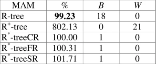
In this section, the main issues concerning the results obtained from our performance experiments are presented and discussed. The first variant of the R*-tree is represented as R*-treeCR, and the performance results have been normalized in terms of the efficiency of this access method. The results specifically indicate an average of the results obtained from the 21 different data files shown in Table 1. In particular, the calculation of this average was derived from the analysis of the relative performance of the access methods (i.e. outcomes normalized in terms of the R* -treeCR) for each one of the data distributions. For each access method, the presented tables show the average together with the columns B and W, which respectively indicate the number of data files that are responsible for the best and worst performance result.
Table 2 presents the performance results obtained from the building phase of the indexing structure, for each multidimensional access method. These results indicated that the efficiency of the R+-tree was significantly degraded due to the use of the clipping technique. When inserting a rectangle, this technique may have requested the allocation of more than an entry in the leaf
nodes. Consequently, the R+-tree achieved the worst performance results, requesting
approximately up to 2,500% more of disk accesses.
In general, the other access methods presented very similar performance outcomes for most of the data files, but the R-tree yielded a slightly higher performance result. Cox [Cox 1991] and Carneiro’s [Carneiro & Magalhães 1998] results indicated that the routine for reinsertion of entries degrades the efficiency of the R*-tree in the insertion of rectangles. According to their experimental outcomes, while it is clear that both access methods R-tree and R*-treeSR performed well, the variants of the R*-tree that used the reinsertion routine presented poor performance results. However, our results showed that the reinsertion routine does not affect the
1 given a k-dimensional iso-oriented rectangle R Ed, find all data objects o enclosing R.
17
efficiency of the R*-tree in the process of inserting rectangles. Similar to the conclusions reported by Beckmann [Beckmann et al. 1990], our experimental results related to the R*-tree performance indicated that the use of the reinsertion routine does not affect its efficiency as we have just stated above. Differently from Beckmann., in our performance tests, conversely, both methods R* -treeCR and R*-treeFR obtained the best performance result in just a single situation. The use of different types of data distribution allowed us to examine both: (i) a performance variation of up to 3,500% in the realm of access methods performance analysis, and (ii) some differences among the relative performance values of these methods.
Table 2 - Performance results obtained from the building phase of indexing structure
MAM % B W R-tree 99.23 18 0 R+-tree 802.13 0 21 R*-treeCR 100.00 1 0 R*-treeFR 100.31 1 0 R*-treeSR 101.71 1 0
Table 3 gives the performance results for the multidimensional access methods that were obtained from executing queries of type point query. These results indicated that the efficiency of both methods R+-tree and R-tree was reduced for most of the data distributions, and that while the first organization class exerts a great influence on the R-tree performance, the R+-tree is strongly affected by the classes of organization two and four.
The outcomes for the other access methods are rather more mixed than for the R-tree and the R+-tree. These results varied according to the data file used and the chosen type of query file
(i.e. uniform or data-correlated). On average, while the method R*-treeSR performed well when
the query file Q1 was used, the R*-treeCR provided better performance results for the query file Q2. In general, the difference among the performance results obtained for the variants of the R* -tree was very small. Again, we verified that the use of different types of data distribution leads to a great variation on the absolute performance values of the MAM (for example, for the R* -treeCR, a performance variation of more than 1,000% was identified in our experiments). In particular, for the R+-tree, our results differ from the good performance outcomes derived from the execution of point queries that are reported in Carneiro [Carneiro & Magalhães 1998]. The difference found in these two research efforts is due to the use of: (i) various types of data distribution, and (ii) a distinct classification of spatial object sizes, which is an important and decisive performance factor.
Table 3 - Execution Phase of Queries (point queries)
MAM Q1 (uniform) Q2 (data-correlated)
% B W % B W R-tree 238.62 3 10 377.05 2 12 R+-tree 271.81 0 11 1,053.88 1 9 R*-treeCR 100.00 4 0 100.00 7 0 R*-treeFR 98.08 7 0 102.97 8 0 R*-treeSR 96.41 12 0 100.69 13 0
For intersection range queries, while the R*-treeFR provided the best average performance results with the use of the query file Q3 (see Table 4), the R*-treeCR presented the best outcomes with query files of type Q4. Regarding the R*-treeSR, this access method showed to be the most
18
efficient approach for most of the data files used and for both types of query files Q3 and Q4. However, on average, the R*-treeSR showed a slightly lower performance result of approximately between 6% and 18% less. Particularly, we verified that for the query file Q3, the efficiency of the R*-treeSR is strongly affected by the fourth organization class, causing 50% more of disk accesses.
The collective location of the data also affected MAM performance investigated in our work. For instance, the access methods R-tree and R*-treeFR obtained a performance variation of 132% and 166%, respectively, for the location subclasses two and twelve (data files A01 and A10). The R-tree performed well for the following data files: A06, A09 and A18. However, for the other files, this method did not show good performance results. Finally, the access method R+ -tree performed badly for all cases examined here. In addition, this approach presented the worst performance outcomes for a large number of data files with both types of query files Q3 and Q4.
Table 4 - Execution Phase of Queries (intersection range queries)
MAM Q3 (uniform) Q4 (data-correlated)
% B W % B W R-tree 235.09 3 7 394.57 3 11 R+-tree 357.80 0 14 2,168.73 0 10 R*-treeCR 100.00 4 0 100.00 11 0 R*-treeFR 95.92 8 0 115.05 6 0 R*-treeSR 96.28 13 0 118.42 9 0
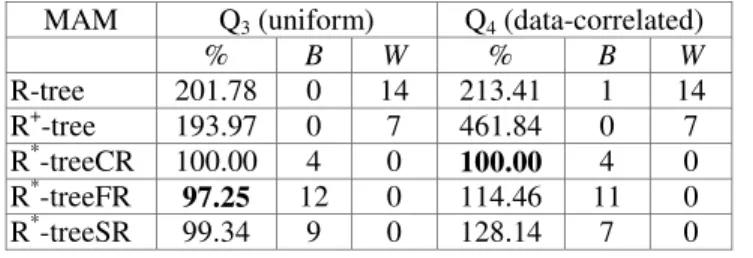
For enclosure range queries, we verified that all variants of the R*-tree provided performance results that are similar to each other. These are shown in Table 5. In particular, the performance difference among the R+-tree and the variants of the R*-tree decreased reasonably for enclosure range queries. For the R-tree, this was also found to be the case, although less intensively.
Table 5 - Execution Phase of Queries (enclosure range queries)
MAM Q3 (uniform) Q4 (data-correlated)
% B W % B W R-tree 201.78 0 14 213.41 1 14 R+-tree 193.97 0 7 461.84 0 7 R*-treeCR 100.00 4 0 100.00 4 0 R*-treeFR 97.25 12 0 114.46 11 0 R*-treeSR 99.34 9 0 128.14 7 0
2.3.5 Summary
The performance results collected from our experiments showed that the spatial data distribution exerts a great influence on both absolute and relative performance outcomes of the MAM. In particular, new performance relationships were identified in our study, some of which contradicted the results and conclusions obtained from previous work, such as Cox [Cox 1991] and Carneiro [Carneiro & Magalhães 1998]. Finding these new relationships was possible particularly due to the use of a methodology for generating sets of data distribution. This methodology, which is based on the spatial data placement, is quite broad and allows the generation of data distributions with different characteristics. This generation allowed us to analyze the decisive performance factor related to the spatial data distribution under distinct