HAL Id: hal-01490887
https://hal.univ-reunion.fr/hal-01490887
Submitted on 16 Mar 2017HAL is a multi-disciplinary open access archive for the deposit and dissemination of sci-entific research documents, whether they are pub-lished or not. The documents may come from teaching and research institutions in France or abroad, or from public or private research centers.
L’archive ouverte pluridisciplinaire HAL, est destinée au dépôt et à la diffusion de documents scientifiques de niveau recherche, publiés ou non, émanant des établissements d’enseignement et de recherche français ou étrangers, des laboratoires publics ou privés.
Distributed under a Creative Commons Attribution| 4.0 International License
SEAS-OI Spatial Data Infrastucture : A tool for the
diffusion of satellite imagery in the South Western
Indian Ocean
Christophe Révillion, Didier Bouche, Thibault Catry, Julien Padeau, Stéphane
Guyard, Mathieu Kazmierski, Jean-François Faure, Jean-Christophe
Desconnets, Yao Télesphore Brou, Aurélie Sand
To cite this version:
Christophe Révillion, Didier Bouche, Thibault Catry, Julien Padeau, Stéphane Guyard, et al.. SEAS-OI Spatial Data Infrastucture : A tool for the diffusion of satellite imagery in the South Western Indian Ocean. ISPRS Geospatial Week 2015, Sep 2015, La Grande Motte, France. �hal-01490887�
See discussions, stats, and author profiles for this publication at: https://www.researchgate.net/publication/282357918
SEAS-OI Spatial Data Infrastucture : A tool for
the diffusion of satellite imagery in the South
Western Indian Ocean
Conference Paper · October 2015 CITATIONS 0 READS 67 10 authors, including: Some of the authors of this publication are also working on these related projects: EOPOWER View project ROSELT View project Christophe Révillion University of La Réunion 10 PUBLICATIONS 3 CITATIONS SEE PROFILE Thibault Catry Institute of Research for Development 9 PUBLICATIONS 0 CITATIONS SEE PROFILE Mathieu Kazmierski Institute of Research for Development 4 PUBLICATIONS 5 CITATIONS SEE PROFILE Jean-Christophe Desconnets Institute of Research for Development 54 PUBLICATIONS 240 CITATIONS SEE PROFILEAll content following this page was uploaded by Jean-Christophe Desconnets on 02 October 2015.
SEAS-OI Spatial Data Infrastucture : A tool for the diffusion of satellite imagery in the South Western Indian Ocean
Christophe Révillion (1), Didier Bouche (2), Thibault Catry (3), Julien Padeau (4), Stéphane Guyard (5), Mathieu Kazmierski (3), Jean-François Faure (3), Jean-Christophe Desconnets
(3), Télesphore Brou (1), Aurélie Sand (6).
(1) Université de La Réunion, UMR ESPACE-DEV, SEAS-OI, Saint-Pierre (2) Université de la Réunion, DSIUN, SEAS-OI, Saint-Pierre
(3) IRD, UMR ESPACE-DEV, Maison de la Télédétection, Montpellier (4) Université de la Réunion, SEAS-OI, Saint-Pierre
(5) Région Réunion, SEAS-OI, Saint-Pierre (6) IRD, UMR ESPACE-DEV, SEAS-OI, Saint Pierre
Highlights : This paper describes the Spatial Data Infrastructure of the SEAS-OI satellite
ground station. The objective of this SDI is to promote the use and to enhance the distribution of satellite data among the scientific community and the public institutions in the Southwest of the Indian Ocean.
Key words : Satellite images, geospatial web services, SEAS-OI, Indian Ocean, SDI Context
During the last decade, the development of standardized web mapping services and Spatial Data Infrastructures (SDI) has facilitated the access to satellite images. This evolution answered the needs of the users to have a quick access to good and effective data.
SDI cover a broad spectrum of applications and users and, while difficult to define, they could be described as “conceptual objective of Spatial Data Infrastructure is to enhance access to and the sharing of spatial data produced by various agencies” (Grus et al., 2007).
Thus, large amounts of data are currently provided free of charge to users through various data catalogs held by the main agencies involved in Earth observation (CNES, ESA, USGS, NASA).
To complete this offer, regional initiatives have been launched to gather various types of local images in a single catalog and to propose specific licenses for regional users (GEOSUD, AGEOS, Kalideos…). This is the case of the SEAS-OI station (Surveillance de
l’Environnement Assistée par Satellites pour l’océan Indien) in Reunion Island.
Operating since July 2012, SEAS-OI is both a satellite receiving station and a center of research, training and promotion of remote sensing. This project is supported by the Regional Council of La Réunion, the French state, the IRD (Institute of Research for Development) and the University of La Réunion.
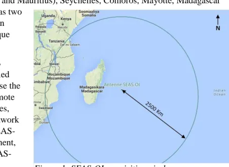
Located in the South of Reunion Island, its acquisition and distribution area encompasses the Mascarene (Reunion, Rodrigues and Mauritius), Seychelles, Comoros, Mayotte, Madagascar and parts of East Africa as well as two
large maritime areas, the Western Indian Ocean and the Mozambique Channel.
The SEAS-OI center and its IDS contribute to a larger project called GEODEV, which aims to increase the use and the competencies in Remote Sensing by sharing methodologies, tools and expertise through a network of similar structures. Besides SEAS-OI, this network under development, also includes GEOSUD and SEAS-Guyane.
Data from the station
The SEAS-OI ground station allows the acquisition, storage and production of optical images (SPOT 4 and 5) and radar images (Radarsat-2). SPOT 6/7, Pleiades and Sentinel data are also available upon request (Table 1).
The data acquired by SEAS-OI are freely available for public institutions and research laboratories based in the Southwest Indian Ocean for non-commercial use as part of research projects or operational activities conducted in the area.
SEAS-OI also provides a cartographic referential throughout Madagascar, the Orthobase, produced from SPOT 5 orthorectified panchromatic images and a SPOT5 HRS derived DEM.
Table 1: Satellite data available at SEAS-OI
Satellites Pixel size Period Area
Spot 4 10m/20m July 2012 -
Jan 2013 Several zones in the area of acquisition Spot 5 2.5m/10m July 2012 –
March 2015
Complete coverage of islands
Spot 6/7 1.5m/6m Since July 2015
Several zones in the area of acquisition
Pléiades 0.5m/2m Since July 2012
Several zones in the area of acquisition
Radarsat-2 3m to100m July 2012 -2015
Complete coverage of islands
Sentinel - 1 5m to100 m Since Oct 2014 Several zones in the area of acquisition
Orthobase Madagascar
2.5m 2013 Madagascar complete coverage
Users
Users of data acquired at SEAS-OI station come from national, regional and local public organizations. Some private companies also use the station data for a strictly non-commercial purpose, mainly in research and development.
Since July 2012, 84 users (Figure 2) required and processed data from the station for more than 90 projects. In total, nearly 1500 products were distributed.
Main objective
Greater visibility of available images and increasing number of requests by actors from various countries are part of the main reasons for the development of an SDI and a web mapping platform. We expect to facilitate access to satellite data and to boost their uses in the southwestern sub-region of the Indian Ocean.
Technical content
For this purpose, an SDI and a distribution web platform were developed by UMR ESPACE-DEV (conception), Geomatys (development) and the “Direction des Services Informatiques” of the University of La Réunion (deployment). The SEAS-OI SDI aims at promoting a broad and rapid dissemination of satellite data in the South-West of the Indian Ocean in order to democratize their use and allow a near real time access. This platform allows authorized users to integrate, describe, search, locate, view, select and download satellite images according to their user or administrator rights.
To achieve this goal, the SDI is based on up-to-date softwares and hardwares for web mapping and data management through OGC standards. Furthermore the integration of data takes into account the recommendations of the INSPIRE Directive.
The SDI hardware is based on a Storage Area Network (SAN) ensuring a continuous data access. In addition, it is based on a logical architecture split into three parts: a data integration server (acquisition and processing), a storage and management server and a broadcast server.
The web architecture, based on Web geospatial services OGC, is interoperable. This point is crucial for the sharing of data between different countries and multiple institutions.
The software solution was developed largely in Java and based on open source tools:
- The PostgreSQL DBMS and PostGIS to store satellite data, metadata, user data and download history;
- The Geotoolkit library to integrate data, to create metadata (in accordance with the INSPIRE standard), to generate pyramids and to reproject;
- The Broadcast webservice is based on Constellation SDI. This solution provided the bulk of OGC standards.
In result, the SEAS-OI SDI is an infrastructure that responds effectively to internal needs and local specificities:
- A backup of data with an easy, flexible and robust handling;
- An automated integration of satellite images and processing for internet diffusion; - A user-friendly web interface that can be used in countries with low-speed internet
(Madagascar, Comoros, Southern Africa).
The current infrastructure is scalable and will gradually integrate new data (SPOT 6/7, Sentinel-1 and 2). This is to respond most effectively to the needs of current and future users. This IDS enhance SEAS-OI’s stature as the regional remote sensing resource center of t South-West Indian Ocean.
Bibliography
Grus, L., Crompvoets, J. W. H. C., & Bregt, A. K. (2007). Multi-view SDI assessment framework. International Journal of Spatial Data Infrastructures Research, 2, 33-53.
The beta version of the web interface is available at http://www2.seas-oi.org/web/guest/catalogue
View publication stats View publication stats