HAL Id: insu-00617806
https://hal-insu.archives-ouvertes.fr/insu-00617806v2
Submitted on 9 May 2012
HAL is a multi-disciplinary open access archive for the deposit and dissemination of sci-entific research documents, whether they are pub-lished or not. The documents may come from teaching and research institutions in France or abroad, or from public or private research centers.
L’archive ouverte pluridisciplinaire HAL, est destinée au dépôt et à la diffusion de documents scientifiques de niveau recherche, publiés ou non, émanant des établissements d’enseignement et de recherche français ou étrangers, des laboratoires publics ou privés.
of the Akdarya Reservoir, Zerafshan River Basin
Shavkat Rakhmatullaev, Frederic Huneau, Masharif Bakiev, Mikael
Motelica-Heino, Philippe Le Coustumer
To cite this version:
Shavkat Rakhmatullaev, Frederic Huneau, Masharif Bakiev, Mikael Motelica-Heino, Philippe Le Cous-tumer. Sedimentation of reservoirs in Uzbekistan: a case study of the Akdarya Reservoir, Zerafshan River Basin. Proceedings of the ICCE Workshop, Sep 2009, Hyderabad, India. 11 p. �insu-00617806v2�
(Proceedings of the ICCE Workshop held at Hyderabad, India, September 2009). IAHS Publ. 349, 2011.
Copyright 2011 IAHS Press
Sedimentation of reservoirs in Uzbekistan: a case study of the
Akdarya Reservoir, Zerafshan River Basin
SHAVKAT RAKHMATULLAEV
1,2,3, FRÉDÉRIC HUNEAU
2,3, MASHARIF
BAKIEV
1, MIKAEL MOTELICA-HEINO
4& PHILIPPE LE COUSTUMER
`1 Tashkent Institute of Irrigation and Melioration (TIIM), 39 Kary Niyazov Street, Tashkent, 100000, Uzbekistan 2 Université de Bordeaux, UFR des Sciences de la Terre, B18 avenue des Facultés, 33405 Talence, France
frederic.huneau@u-bordeaux1.fr
3 Institut EGID, EA Géoressources et Environnement, 1 allée F. Daguin, 33607 Pessac, France
4 Université d'Orléans, UMR 6113 CNRS/INSU Institut des Sciences de la Terre d'Orléans, Campus Géosciences 1A,
rue de la Férollerie 41071 Orléans, France
Abstract The major rivers of Central Asia (Amu Darya, Syr Darya and Zerafshan) are turbid watercourses.
Thus many man-made water reservoirs are affected by high sedimentation rates. It is of strategic importance to rationally quantify available water resources in existing reservoirs to ensure a guaranteed water supply to the different water users. Recent drought years and physical deterioration of hydraulic structures urged authorities to re-estimate the water availability in reservoirs of Uzbekistan for the sustainable use of the scarce water resources and safe operation of hydraulic infrastructure. This paper presents the results after the application of a geostatistical approach to assess the water resources availability in the Akdarya reservoir of Uzbekistan. The geostatistical approach creates digital surfaces that represent relatively accurate reservoir bottom conditions and support automated reservoir volumes and surface areas calculations. This in turn significantly reduces time, work load and financial burdens for sedimentation survey projects.
Key words water management; erosion; sedimentation; water reservoirs; bathymetric survey; geostatistics;
volume estimation; Central Asia
INTRODUCTION
The reservoir sedimentation is a practical issue in many parts of the world with different climatic conditions and level of engineering sophistication (Petts & Gurnell, 2005; Radoane & Radoane, 2005; Walling, 2006). Reservoirs affect water and sediment cycles of the riverine systems globally. Vörösmarty et al. (2003) states that globally, more than 50% of the basin-scale sediment fluxes in regulated basins are potentially trapped in artificial impoundments, with discharge-weighted sediment trapping of about 30% due to large reservoirs and an additional contribution of about 23% from small reservoirs.
Sedimentation triggers several important issues such as operation and maintenance of engineering infrastructures, economical feasibility of the project, environmental problems with social aspects upstream and downstream (McManus, 1985; Brandt, 2000; WCD, 2000; Davis & Koop, 2006; Graf, 2006; Sternberg, 2006). It is reported that annually an average 0.5–1% of the volume capacities of small and large reservoirs is lost because of sedimentation in the world (Mahmood, 1987). Palmieri et al. (2001) reports, that the loss in volume capacity requires an annual replacement cost of US$ 13 billion dollars.
Some experts argue that within the Central Asian region, global warming will have a severe impact on the formation of water resources in the mountain systems of the Tian Shan and Pamir-Alay because of the decrease in ice cover (Aizen et al., 1997; Hagg et al., 2007; Olsson et al., 2010). In fact, these mountain systems are major contributors to the watersheds of the region. Lioubimtseva et al. (2005) reports that since the beginning of the 20th century, a general warming trend in Central Asia, of the order of 1–2°C, has been observed, which might have a potential impact on the regional temperature, evaporation, and precipitation regimes. According to the estimates made by the Uzbekistan Hydro Meteorological Committee, the pessimistic scenarios of water resource transformations describe a reduction of the river discharges by 15–20% and 20–30% for the Syr Darya River and the Amu Darya River, respectively (UNEP, 2005; UNDP, 2007).
In the Central Asian region, the primary source for irrigation is the surface flow from rivers and man-made reservoirs (Rakhmatullaev et al., 2009b). However, the region is known as an area
with an erratic natural precipitation, uneven spatial and temporal water resource distribution, and arid climatic conditions.
In fact, reservoirs store water during wet periods to make it available during dry periods, and in so doing, regulate floods, generate hydropower, and enable irrigation (Irrigation of Uzbekistan, 1981; World Bank, 2003). There are more than 290 water reservoirs in the region with a total volume capacity over 163 km3 that regulate more than 50% of the monthly regions river flow and the area occupied by reservoirs constitutes roughly 6% of the Central Asian countries irrigated areas (Skrilnikov et al., 1987; Nikitin, 1991; Rubinova, 2000; Rakhmatullaev et al., 2010a,b). For example, on average about 30% of irrigation water is delivered from reservoirs, ranging from as high as 54% in Turkmenistan and as low as 13% in Kyrgyzstan (UNEP, 2005).
Water reservoirs of Uzbekistan
The total cultivated land in Uzbekistan is estimated to be about 5.2 million ha, of which 4.2 million ha are irrigated. In fact, about 24% of irrigation water in Uzbekistan comes from water reservoirs. In Uzbekistan, the total gross volume capacity of all reservoirs (55) is about 19 km3, and the useful volume capacity is about 14.5 km3, whereas the total surface area of reservoirs is estimated at approx. 1450 km2 (Rakhmatullaev et al., 2010c).
The total reservoir volume capacity is defined as the maximum amount of water stored, whereas the useful volume capacity is the actual available water storage. The arithmetical difference between the two values is defined as the dead storage of a reservoir. In other words, the dead volume storage in a reservoir is determined as the storage volume between the stream bed and the lowest elevation from which water can be withdrawn by gravity (ICOLD, 2010). The difference observed between the total capacity and the useful capacity is an indicator of the efficiency of dam and water management. The 4.5 km3 difference represents a loss of 26% that is due to topographic peculiarities, i.e. most of the water reservoirs are constructed in the lowlands of Uzbekistan.
According to the Ministry of Agriculture and Water Resources of the Republic of Uzbekistan, out of the 27 inspected reservoirs, 11 are almost completely silted up, and at 5 other reservoirs the silt has almost reached the level of the outlet structures (Rakhmatullaev et al., 2009a).
Table 1 depicts the annual sedimentation rates of design phase (pre-impoundment) estimates and direct measurements in the operation phase of those reservoirs.
Table 1 Annual sedimentation rates of several important water reservoirs in Uzbekistan.
Reservoir Annual sedimentation rate (Mm3/year) Difference Design Measured Akhangaran 0.07 0.43 6.2 Pachkamar 0.28 1.94 6.8 Kayrakum 19.0 26.5 1.4 Chimkurgan 1.2 4.3 3.6 Ujno-surkhan 6.8 7.6 1.1 Kuyamazar 0.37 0.68 1.8 Talimarjan 1.8 2.2 1.2 Kattakurgan 0.08 0.14 1.6 Kassansay 0.2 0.15 0.8 Tuyamuin 47.5 64.3 1.4 Tuyabuguz 1.12 1.88 1.7
It can be seen that there is a significant difference between the design estimates and measured sedimentation rates ranging from 0.8- to 6.8-fold, which indicates that many man-made water reservoirs will be silted up very soon against design estimations. This is an alarming signal that in
a foreseen future the sedimentation can be a major operation and maintenance issue for these reservoirs and threaten for guaranteed water supply to water users in Uzbekistan.
In addition, the erosion by water and irrigation has increased due to the incorrect irrigation methods, deforestation, overgrazing and to the increase of irrigated areas on steep slopes. According to a recent study by the UNDP, around 0.8 million ha of land is subject to water erosion and more than 2.3 million ha suffered from wind erosion in Uzbekistan (UNDP, 2007).
In Uzbekistan, bathymetric surveys were carried out with traditional methods such as range survey/end area method, for the calculation of reservoir volume and surface area for different reservoir stages. Traditional methods of analysis have relied on the topographic mapping and range survey data to estimate sediment volumes for a reservoir. The traditional range survey/end area method has provided adequate results for past sedimentation analysis (USACE, 2001; IHO, 2005).
New technologies such as GPS (Global Positioning System), acoustic depth measurement systems and contour mapping software have proved to increase geo-referenced data, improve the accuracy of data and most importantly substantially decrease the expenses of the bathymetric studies (Joseph et al., 1998; Ortt et al., 2000; Soler-Lopez, 2004; Furnans & Austin, 2008).
A geostatistical approach can be very helpful, reliable and efficient tools to increase the number of point measurements at unsampled places and variogram analysis for examining the structural relationship of data for anisotropy analysis of a physical process that can have changed characteristics in the direction and space over traditional methods for bathymetric surveys (Goovaerts, 1999).
The primary objective of this paper is a bathymetric survey using a new acoustic depth measurement system coupled with GPS and application of geostatistical approach of the Akdarya reservoir for the estimation of the reservoir volume and surface area for corresponding reservoir stages (water elevations), in order to quantify the water availability impounded behind the reservoirs due to sedimentation. Volume and surface area differences derived from multiple surveys of individual reservoirs then provide estimates of capacity loss over time due to sedimentation. Furthermore, there is an attempt to predict the Akdarya reservoir volume losses under pertinent simplification assumptions without complex process involving hydrology, hydrogeology, morphology and dam engineering.
STUDY AREA
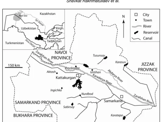
The Akdarya reservoir was created by the construction of an earthen dam on the Akdarya River in 1982 (Samarkandgiprovodhoz, 1976). This reservoir is used as a seasonal flood regulating structure, for irrigation of some 5500 ha of new agricultural lands and to improve the conditions of more than 12 000ha of the irrigated lands in two districts of the Samarkand province of Uzbekistan (Fig. 1).
The modern Akdarya River valley is in-filled with pro-alluvium deposits. The valley is layered by loess and loams with 5–40 m thickness, underlying a layer of gravel with a thickness of about 300 m. The modern flood plain part of the Akdarya River is composed of loams, stones and pebbles of alluvial origin. The thickness of modern deposits varies from 0.5 to 5 m (Rakhmatullaev, 2010b). The river channel is well defined, composed of pebble-cobble deposits. The absolute elevation of the river varies from 680 m to 400 m above sea level. On the right bank, the relief of surrounding areas is presented by the hills with smooth peaks changing into alluvial and pro-alluvial uplands. The left bank is composed of flood plains and terrace valleys (Uzdavsuvloixa, 2002).
MATERIALS AND METHODS Depth measurements
The bathymetric survey of Akdarya reservoir was conducted in 2003 from a moving boat using electronic depth-sounding equipment (transducer) in conjunction with a GPS antenna and an
Fig. 1 Location of the Akdarya Reservoir in Samarkand province of Uzbekistan, Central Asia.
automatic data recorder CEEDUCER®. The GPS receivers monitor the horizontal position of the survey boat, while the depth sounder measures the water depth. The GPS units were by default were automatically converted into a WGS84 (World Geodetic System of 1984) projection system.
One GPS unit was installed at the reference station; the other GPS unit was installed in the survey boat to be used as a mobile station. The GPS on board independently calculated a position every second, while receiving a set of correction signals from the reference station, converting the system into a DGPS. This combination maintained the data horizontal position accuracy within a tolerance of two metres (USACE, 2001; IHO, 2005; Furnans & Austin, 2008).
Sounding equipment was used to measure depth from a transducer (probe), operating at a frequency of 200 kHz to the bed of the reservoir. Depths recorded by the sounder, which has a resolution of 0.02%, were measured at a fixed distance below the water surface. The recorded depths and the constant value of the depth ecosounder were subtracted from the water surface elevations at the time of the survey (as recorded at the dam gauge) to determine reservoir bottom elevations. The calibration of the transducer was performed twice daily, before and after the measurements collection (Bathymetric Center, 2003).
For the shallow water areas, where transducer could not be operated, representative depth measures were manually collected with a stadia rod from the boat. However, sediment accumulation and vegetation growth in the upstream reservoir areas limited the data collection. The shoreline delineation was performed during the survey by GPS receiver as close as probable to water surface marks along the reservoir shoreline.
Initial editing of the data was performed using the MiniCee® software. Position and depth data errors were corrected by interpolating back to the mid-point between the correct antecedent and preceding position. Once corrected, the edited data were transferred into the Golden Software’s SURFER® 7 database for further processing.
Variogram modelling
With recent progresses in automatic calculations, the use of geostatistics for the spatial analysis of environmental data has become extremely common both on land and sea (Mear et al., 2006). Geostatistics include tools that establish surface maps of any interested variable from the analysis
of the spatial structure of data (semivariogram) and to predict the value (interpolation) of these parameters at unsampled points (kriging or simulation).
Variogram analysis was used to examine the spatial or temporal correlations of the data. Variogram analysis is a prerequisite for interpolation (kriging or simulation) or making predictions (Clark, 2001). Variogram analysis consists of the experimental variogram calculated from the data and the theoretical model fitted to the data. The experimental variogram measures the mean variability between two points z and z+h, as a function of their distance h.
The experimental semi-variogram is calculated by the following equation:
h x x 2 i j h j i ) x ( z ) x ( z N 2 1 ) h ( ˆ (1)where γ(h) is the experimental semi-variogram taking into account the difference in value between pairs of samples with a given relative orientation and distance apart (h) between two measured attributes (depth); h is the distance between two discrete points that are used for variogram calculation; n is the number of pairs of samples for a given h; z is the investigating attribute (depth); i and j are the indexes of respective values of two samples apart of the distance h.
The experimental variogram is calculated for several lag distances and is plotted as a two-dimensional graph γ(h) = f(h). It is then fitted with a theoretical model which provides information about the structure of the spatial variation, as well as the input parameters for spatial prediction by kriging (Saby et al., 2006).
The kriging is used as an estimation method for minimizing the best interpolation errors and allowing the calculation of variance associated with the interpolation. Kriging calculates a weighted moving average equation, which estimates the value of a regionalized variable at site specific location by taking into account the variographical information. The optimum grid size for the construction of the bathymetric surfaces was determined based on examination of the sampling distribution for the three periods. The kriging interpolation gives the averaged smoothed surface and thus underestimates the realistic reservoir volume and surface area calculation.
RESULTS AND DISCUSSION
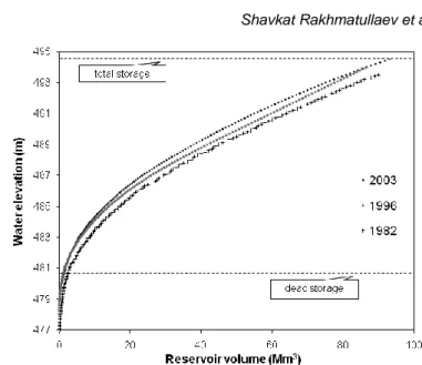
For determination of sedimentation rates three bathymetric surveys, the original (pre-impoundment) in 1982, 1996 and 2003, were used to examine the evolution of reservoir capacity over time. The 1982 and 1996 surveys were carried out by traditional methods, such as range survey/end area method and traditional measuring instrumentation. The 2003 survey was carried out as previously described by CEDUCEER®. Figure 2 depicts the volume curves of the Akdarya reservoir for the three surveys.
The volume storage capacity loss rate is a key component for calculating the remaining life of a reservoir (Ortt et al., 2000). Using the volumes of accumulated sediment and the age of the reservoirs, the annual storage capacity loss rates can be calculated. During the 21 years of reservoir operation, the total loss of reservoir capacity due to sediments is estimated to be about 19.3 Mm3. The Akdarya reservoir has lost its storage capacity at a rate of 0.92 Mm3 per year. As a percentage of its original storage volume, the annual loss rate for Akdarya reservoir is 0.8% up to 2003. The high rate of loss is explained by the significant right-bank erosion processes in some places reaching 20–50 m collapses and local geomorphologic conditions with high sediment amounts coming from surrounding agricultural lands in the event of storms.
With traditional methods of depth measurements and few sampled points, large errors and uncertainties are observed that increase errors in computation of water availability in water reservoirs. The potential sources of error are: (i) human induced during the data measurement in operation of the boat, and (ii) readings of the transducer (e.g. penetration of sonar signal through the water column and poor acoustic reflection of signal back from true reservoir bottom surface) (Byrnes et al., 2002; IHO, 2005).
Fig.2 Historical volume curves of the Akdarya Reservoir.
Fig. 3 Experimental semivariogram of reservoir bottom elevations direction N20 (smallest variance)
and N110 (largest variance) of Akdarya reservoir.
Variographical analysis
First, the experimental semivariogram was calculated and constructed from the direct field measurements. Figure 3 depicts the semivariogram of reservoir bottom elevations for the Akdarya reservoir.
The directional variograms were computed every 10° and with a 200 m lag. In this case the directional variograms showed spatial correlations and the anisotropy was observed in two principal directions are N20 and N110. For lags less than 1200 m, the smallest variance was observed in the direction of N110 and the largest variance in the direction of N20. Furthermore the variogram showed a stationnarity for N20 (with a sill equal to 9 m2 for a range of 800 m, distance beyond for which there is no correlation between data) and a non-stationary behaviour for N110.
Secondly, the theoretical model was fitted with a spherical model and the anisotropy was defined as the ratio between the largest and the smallest variance (Fig. 3, dotted charts). The fitting was the best for h less than 1000 m, because of neighbourhood problems, which has been addressed by the kriging.
After the variogram analysis, the interpolation was carried out using a kriging gridding method. In order to estimate a value at a non-sampled point, we considered measured points in a
given neighbourhood. The chosen neighbourhood was an ellipse with axes equal to 1000 m and 500 m in N110 and N20 directions, respectively. The ellipse was then decomposed in 4 sectors and we chose to have an optimum number of data equal to 10 in each sector.
Figure 4 illustrates the bathymetry of Akdarya reservoir by kriging interpolation method.
Fig. 4 Bathymetric map of Akdarya reservoir by kriging interpolation method.
The process of obtaining an accurate bathymetric survey is substantially more difficult than that associated with land-based surveying. There are various error sources in data acquisition and measurement in bathymetric survey such as GPS limited availability, the definition of the water– mud interface and human errors in measurements (USACE, 2001; IHO, 2005).
The 2-D bathymetric map has visualization effect for a reservoir operator who can use this information in decision making over operation and maintenance works. This is particularly important for the water intake structures that are installed in a reservoir for irrigation diversions or public water supply systems. Operators could take site specific preventive measures to alleviate such scenarios.
The volume and area calculations for the Akdarya reservoir both direct measurements and estimations by kriging have shown satisfactory results (Table 2).
Table 2 Volume and area of the Akdarya Reservoir from direct measurements and estimated by
geostatistical method. Water elevation (m) Reservoir volume (Mm3) Reservoir area (km2)
Direct measurement Estimated Direct measurement Estimated
477 0.003 0.00074 0.0083 0.0036
480.5 1.12 1.05 0.95 0.97
485 12.76 12.63 4.39 4.42
490 46.04 46.27 8.62 8.66
494.5 93.17 93.83 13.98 13.97
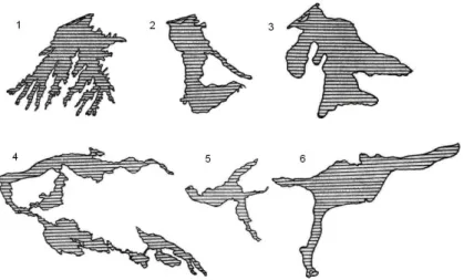
One of the principal findings of the research was that variogram modelling should be carried out paying special attention for the morphological configuration of the water reservoirs. In the study case, the Akdarya reservoir has a simple prolonged shape where the principal directions were very easily found. In fact, there are numerous water reservoirs with complex morphological
shapes depicted in Fig. 5. For these cases, several variograms should be examined and then bathymetric models can be calculated.
Fig. 5 Morphological shapes of several water reservoirs in Central Asia (adopted and modified from
Nikitin, 1991): (1) Kattakurgan; (2) Tuyabuguz; (3) Andijan; (4) Tuyamuin; (5) Charvak; (6) Toktogul.
Forecasting of the Akdarya reservoir volume loss
The following equation is used for the prediction of the reservoir volume losses in the Akdarya reservoir.
Rannual = (Vi – Vf)/t (2)
where: Rannual is the mean annual actual sedimentation volume (Mm 3
/year); Vi is the initial
reservoir volume (Mm3); Vf is the final reservoir volume (Mm3); t is the number of years (year).
For the estimation of the percentage of annual loss of the reservoir volume capacity the following equation is used:
R% = (Rannual/Vi) 100 (3)
The results of prediction calculations are given in Fig. 6.
After the annual reservoir volume storage loss is known then we have taken a 10-year increment for prediction calculations. For example, there will be an 85% loss of dead storage capacity in 2025, i.e. it means that almost designed volume for sedimentation will have vanished. In 2047 almost 50% of the useful reservoir storage capacity will be lost, thus expensive dredging activities should be carried out for a proper use of this hydraulic infrastructure.
In order to validate our predictions we have examined the design documentation of the project and other existing estimates of sedimentation and loss of the reservoir capacities. For example, according to the estimates of design organization Uzdavsuvloikha (2002) which carried out its forecast, 23% of the full Akdarya reservoir capacity will be lost due to sedimentation by 2032. In contrast, according to our estimates 42% of the same capacity will be decreased due to sedimentation. The two-fold difference can be explained by the land use changes in the watershed, about 8–10% of the Akdarya reservoir area is planted by rice paddy fields. In addition, the same comparison was performed to the estimates for sedimentation loads, according to the same organization for the period 1985–2005 the total sedimentation volume will be 10.9 Mm3 whereas our estimate for the same period is 19.3 Mm3.
CONCLUSION AND PERSPECTIVES
Traditional bathymetric methods are still practical methods for estimating reservoir sedimentation in the region. However, new advances in technologies for depth measurement, contour and mapping programs eased calculation of reservoir sedimentation and can substantially reduce the costs of such research projects. GIS, GPS and remote sensing capabilities have shown promise for reducing time and workload and decreasing costs for reservoir sedimentation studies.
Mixon et al. (2008) developed an algorithm for geolocation of reservoirs using GIS for watersheds across the continental United States and described the land use, soils, and topography for each reservoir’s watershed. The authors argue that the method of basin characterization should aid large-scale studies of sedimentology, hydrology, and biogeochemistry.
Verstraeten (2006) has shown the great potential of a simple sediment delivery model like WATEM/SEDEM to predict the hillslope sediment delivery to river channels at regional scales when it is used with Shuttle Radar Topography Mission (SRTM) elevation data. SRTM data are available at 3″ resolutions for many parts of the world, this offers opportunities not only to make more accurate predictions of the total amount of sediment delivered to river channels for the larger river basins, but also to delineate ―hot spots‖ within each river basin that contribute to a lot of sediment. This has important implications for river basin management and in particular to reservoir sedimentation management.
Wang & Philpot (2007) discuss Airborne Lidar Bathymetry (ALB) that is designed to measure the depth of the water based on the two-way travel time of a short pulse of light between the water surface and the bottom. An advantage of the lidar system is that it is capable of measuring the water depth from 1.5 m down to 60 m, depending on the water clarity.
Leu & Chang (2005) demonstrated the applicability of wave spectrum bathymetric (WSB) method with the use of remote sensing for obtaining bathymetry of shallow water in terms of costs and workload. Assuming that the frequency of wave does not change, and the general dispersion relation between the water depth and the wavelength holds during the wave propagation, one can determine the coastal water depths from the spatial variation of the wave spectra. This WSB method has feasible application because it does not depend on other environmental data, like the water quality and bottom reflectivity for the optical method.
Remote sensing is another powerful tool that has been used for assessment of reservoir volume capacities. For example, Sawunyama et al. (2006) investigated the relationship between remote-sensed small reservoir surface areas to estimate its capacity in Limpopo river basin, Africa. The authors concluded that for small impoundments it is valid with field measurements to use satellite remote sensing technology for estimation of reservoir volume capacities.
In Uzbekistan, the reservoir sedimentation surveys were carried out with traditional range survey/end area method over the years. Since the 2003 reservoir sedimentation surveys have been conducted with new bathymetric system that incorporates GPS and electronic transducer capabilities. However, manual data management persists in the practice, which is tedious and costly with large human-induced errors for calculation of reservoir volume.
The geostatistical approach has many advantages compared to the traditional computation methods with statistical analysis of data variance and known fitting mathematical model for interpolation. The kriging interpolation method is a good first approximation.
With the application of GIS capabilities, Google Earth® and computer surface mapping software technologies, the new data management schemes at the national scale can be envisioned with the creation of digital maps of reservoirs for sustainable operation of Uzbekistan environment and physical infrastructure for the coming years.
Acknowledgements The authors would like to thank the French Embassy in Tashkent for supporting the French-Uzbek cooperation in the field of water sciences. This study has also been supported by INTAS fellowship no. 04-83-3665 and by the French Ministry of Foreign Affairs via the Eiffel fellowship program no. 530909C. However, the views expressed in this paper do not necessarily reflect those of the funding agencies, and no official endorsement should be inferred from it.
REFERENCES
Aizen, V., Aizen, E., Melack, J. & Dozier, J. (1997) Climatic and hydrologic changes in the Tien Shan, Central Asia. J. Climate. 10, 1393–1404.
Bathymetric Center (2003) Estimation of Ak Darya reservoir capacity using CEEDUCER. Technical report. Uzbekistan Ministry of Agriculture and Water Resources, Tashkent, Uzbekistan (in Uzbek).
Brandt, S. A. (2000) Classification of geomorphological effects downstream of dams. Catena 40, 375–401.
Byrnes, M. R., Baker, J. L. & Li, F. (2002) Quantifying potential measurement errors and uncertainties associated with bathymetric change analysis. Coastal and Hydraulics Engineering Technical Note. US Army Corps of Engineers. ERDC/CHL CHETN-IV-50.
Clark, I. (2001) Practical geostatistics. Central Scotland, UK.
Davis, R. J. & Koop, K. (2006) Eutrophication in Australian rivers, reservoirs and estuaries—a southern hemisphere perspective on the science and its implications. Hydrobiologia 559, 23–76.
Furnans, J. & Austin, B. (2008) Hydrographic survey methods for determining reservoir volume. Environ. Modelling Software
23, 139–146. doi: 10.1016/j.envsoft.2007.05.011.
Graf, W. L. (2006) Downstream hydrologic and geomorphic effects of large dams on American rivers. Geomorpholog. 79, 336–360.
Goovaerts, P. (1999) Geostatistics in soil science: state-of-the-art and perspectives. Geoderma 89, 1–45.
Hagg, W., Braun, L. N., Kuhn, M. & Nesgaard, T. I. (2007) Modelling of hydrological response to climate change in glacierized Central Asian catchments. J. Hydrol. 332, 40–53.
International Commission on Large Dams (ICOLD) (2010) http://www.icold-cigb.org (accessed 15 June 2010).
International Hydrographic Organization (IHO) (2005) Manual on Hydrography. Publ. no. M-13. 1st edn. Monaco. http://www.iho.shom.fr.
Irrigation of Uzbekistan (1981) Technological Progress in Irrigation, vol 4. Publ. Fan, Tashkent, Uzbekistan.
Joseph, A., Bernert, J. A. & Sullivan, T. J. (1998) Bathymetric analysis of Tillamook Bay: comparison among bathymetric databases collected in 1867, 1957 and 1995. March. E&S Environmental Chemistry, Inc. Corvallis, Oregon, USA. Leu, L. G. & Chang, H. W. (2005) Remotely sensing in detecting the water depths and bed load of shallow waters and their
changes. Ocean Engng 32, 1174–1198.
Lioubimtseva, E., Cole, R., Adams, J. M. & Kapustin, G. (2005) Impacts of climate and land-cover changes in arid lands of Central Asia. J. Arid Environ. 62, 285–308.
Mahmood, K. (1987) Reservoir Sedimentation: Impact, Extent and Mitigation. World Bank Publ. Washington, DC, USA. McManus, J. (1985). Physical processes of reservoir sedimentation. In: Methods of Computing Sedimentation in Lakes and
Reservoirs (ed. by S. Bruk). International Hydrological Programme, IHP-II Project, A.2.6.1.Panel, 11-40. UNESCO, Paris, France.
Mear, Y., Poizot, E., Murat, A., Lesueur, P. & Thomas, M. (2006) Fine-grained sediment spatial distribution on the basis of a geostatistical analysis: Example of the eastern Bay of the Seine (France). Continental Shelf Res. 26: 2335–2351. doi:10.1016/j.csr.2006.06.009
Mixon, D. M., Kinner, D. A., Stallard, R. F. & Syvitski, J. P. M. (2008) Geolocation of man-made reservoirs across terrains of varying complexity using GIS. Computers and Geosciences. doi:10.1016/j.cageo.2008.02.015.
Hydrometeoizdat. Leningrad, Russia.
Olsson, O., Gassmann, M., Wegerich, K. & Bauer, M. (2010) Identification of the effective water availability from streamflows in the Zerafshan river basin, Central Asia. J. Hydrol. 390, 190–197.
Ortt, R. A. Jr., Kerhin, R. T., Wells, D. & Cornwell, J. (2000) Bathymetric survey and sedimentation analysis of Loch Raven and Prettyboy reservoirs. Maryland Geological Survey. Coastal and Estuarine Geology File Report no. 99-4.
Palmieri, A., Shah, F. & Dinar, A. (2001) Economics of reservoir sedimentation and sustainable management of dams. J. Environ. Manage. 61, 149–163.
Petts, G. E. & Gurnell, A. M. (2005) Dams and geomorphology: Research progress and future directions. Geomorphology 71, 27–47.
Radoane, M.. & Radoane, N. (2005) Dams, sediment sources and reservoir silting in Romania. Geomorphology 71, 112–125. Rakhmatullaev, S., Huneau, F., Le Coustumer, P., Motelica-Heino, M. & Bakiev, M. (2010a) Facts and perspectives of water
reservoirs in Central Asia: a special focus on Uzbekistan. Water 2, 307–320. doi:10.3390/w2020307.
Rakhmatullaev, S., Marache, A., Huneau, F., Le Coustumer, P., Bakiev, M. & Motelica-Heino, M. (2010b) Geostatistical approach for the assessment of the water reservoir capacity in arid regions: a case study of the Akdarya reservoir, Uzbekistan. Environ Earth Sci. doi: 10.1007/s12665-010-0711-3.
Rakhmatullaev, S., Huneau, F., Le Cousumer, P., Motelica-Heino, M. (2010c) Sustainable irrigated agricultural production of countries in economic transition: Challenges and opportunities (a case study of Uzbekistan, Central Asia). In: Agricultural Production. (ed. by F. C. Wager). Nova Science Publ. New York, USA, ISBN: 978-1-61668-695-6.
Rakhmatullaev, S., Bakiev, M., Le Cousumer, P., Huneau, F. & Motelica-Heino, M. (2009a) Reservoir sedimentation in Uzbekistan: Case study of the Akdarya reservoir. In: A Vital Resource Under Stress – How Science Can Help (Joint International Convention of 8th IAHS Scientific Assembly and 37th IAH Congress Water, September 6–12, 2009, Hyderabad, India).
Rakhmatullaev, S., Huneau, F., Kazbekov, J., Le Coustumer, P., Jumanov, J., El Oifi, B., Motelica-Heino, M., Hrkal, Z (2009b) Groundwater resources and management in the Amu Darya River Basin (Central Asia). Environ. Earth Sci. 59, 1183– 1193. doi:10.1007/s12665-009-0107-4.
Rubinova, F. E. (2000) Water reservoirs of Aral Sea basin and their impact on water quantity and quality. In: Water Resources, Issues of Aral Sea and Environment, 77–98, Universitet Publ. Tashkent, Uzbekistan.
Saby, N., Arrouays, D., Boulonne, L., Jolivet, C. & Pochot, A. (2006) Geostatistical assessment of Pb in soil around Paris, France. Sci. Total Environ. 367, 212–221. doi:10.1016/j.scitotenv.2005.11.028.
Samarkand hydrological design institute (Samarkandgiprovodxoz) (1976) Feasibility study of dam construction on Ak Darya river, Kattakurgan district, Samarkand province (in Russian). Feasibility study report.
Sawunyama, T., Senzanje, A. & Mhizha, A. (2006) Estimation of small reservoir storage capacities in Limpopo River Basin using geographical information systems (GIS) and remotely sensed surface areas: Case of Mzingwane catchment. Physics and Chemistry of the Earth 31, 935–943.
Skrilnikov, V. A., Keberle, S. I. & Beleskov, B. I. (1987) Improvement of Reservoir Operation Efficiency. Mehnat Publ. Tashkent, Uzbekistan.
Sternberg, R. (2006) Damming the river: a changing perspective on altering nature. Renewable and Sustainable Energy Reviews
10, 165–197.
Soler-Lopez, L. R. (2004) Sedimentation survey of Lago Toa Vaca, Puerto Rico, June-July 2002. US Geological Survey Scientific Investigations Report no. 2004-5035.
United Nations Environmental Programme (UNEP) (2005) Global International Waters Assessment: GIWA Aral Sea Regional Assessment 24, University of Kalmar Publ. Kalmar, Sweden.
United Nations Development Programme (UNDP) (2007) Water: Critical Resource for Uzbekistan’s Future, UNDP Country Office for Uzbekistan Publ. Tashkent, Uzbekistan.
United States Army Corps of Engineers (USACE) (2001) Hydrographic surveying engineering manual. Engineering and design. No. 1110-2-1003. Washington DC, USA.
Uzbekistan state water design institute (Uzdavsuvloiha) (2002) Estimation of hydrological characteristics of Ak Darya reservoir in Samarkand province (in Russian). Technical report. Tashkent, Uzbekistan
Verstraeten, G. (2006) Regional scale modelling of hillslope sediment delivery with SRTM elevation data. Geomorphology 81, 128–140.
Vörösmarty, C. J., Meybeck, M., Fekete, B., Sharmad, K., Green, P. & Syvitski, J. M. P. (2003) Anthropogenic sediment retention: major global impact from registered river impoundments. Global Planetary Change 39, 169–190.
Walling, D. E. (2006) Human impact on land–ocean sediment transfer by the world's rivers. Geomorphology 79, 192–216. Wang, C. K. & Philpot, W. D. (2007) Using airborne bathymetric lidar to detect bottom type variation in shallow waters.
Remote Sens. Environ. 106, 123–135.
World Commission on Dams (WCD) (2000) Dams and Development: a New Framework for Decision-Making. Earthscan Publ. London, UK.
World Bank (2003) Irrigation in Central Asia: social, economic and environmental considerations. http://www.worldbank.org/eca/environment (accessed 12 January 2008).