HAL Id: hal-01171544
https://hal.archives-ouvertes.fr/hal-01171544
Preprint submitted on 7 Jul 2015HAL is a multi-disciplinary open access archive for the deposit and dissemination of sci-entific research documents, whether they are pub-lished or not. The documents may come from teaching and research institutions in France or abroad, or from public or private research centers.
L’archive ouverte pluridisciplinaire HAL, est destinée au dépôt et à la diffusion de documents scientifiques de niveau recherche, publiés ou non, émanant des établissements d’enseignement et de recherche français ou étrangers, des laboratoires publics ou privés.
Public Domain
Rural Landscape and Borderland Farming on the upper
Rhine Frontier in roman Times
Michel Reddé
To cite this version:
Michel Reddé. Rural Landscape and Borderland Farming on the upper Rhine Frontier in roman Times : Evaluating the case of Oedenburg (Haut-Rhin, France). 2015. �hal-01171544�
RurLand
Dossiers du programme européen “Rural Landscape in north-eastern Roman Gaul”
dirigé par Michel Reddé, directeur d’études à l’École pratique des Hautes Études (EPHE)
RURAL LANDSCAPE AND BORDERLAND FARMING
ON thE UPPER RhINE FRONtIER IN ROMAN tIMES :
EVALUAtING thE CASE OF OEDENBURG (hAUt-RhIN, FRANCE)
Michel Reddé*
Document 2
Introduction : feeding the Roman army and the site of Oedenburg
For some time now attention has been drawn to the limitedcapacity of the Dutch river area to supply the Roman army settled along the Rhine, especially during the phase of conquest when the population surged within a few years (Kooistra 1996; Cavallo & Kooistra 2008). In this ‘non-villa landscape’ (Roymans & Derks 2011; Habermehl 2013) where the sandy soils were unable to pro-duce surpluses and were traditionally given over to animal hus-bandry rather than wheat production, cereals for the army had to be imported from abroad and especially from northern Gaul (Reddé 2011b; Roymans 2014). Although some adjustments have recently been made to this claim (Kooistra & Van Dinter 2013; Van Dinter & Kooistra 2014), the rural landscape of the Rhine delta was not as productive in Roman times as, say, the loess countries further south or Picardy in modern France. But the question of a sustainable farming system to supply the Roman army should not be confined to the Dutch river area. In the upper Rhine valley, between Strasbourg (France) and Basel (Switzerland), where the geological and geomorphological conditions are quite different, the development of the Roman Frontier in the early first century AD raises the same question: Was the country ready to feed the army and how? Recent excavations at the Gallo-Roman site of Oedenburg (Biesheim-Kunheim, Haut-Rhin, France) cast some new light on this subject.
* Directeur d’études à l’École Pratique des Hautes Études, Paris; redde.michel@yahoo.fr
Kaiser-stuhl Strasbourg Oedenburg Breisach Colmar Bâle N 0 10 km Ill Elz Ill Rhin
+ Fig. 1. The site of Oedenburg in its regional setting (M. Reddé).
- 2
RurLand
Camp B Camp A Riedgraben (Julio-Claudian period) Sanctuary Valentinian Fortress road station (2nd c) road station (4th c.) 4th c. Ditch ALTKIRCH 0 100 m+ Fig. 2. Schematic topography of the Oedenburg site after information from geomagnetic prospecting (Posselt & Zickgraf Prospektionen), aerial photographs and excavations (M. Reddé).
The site of Oedenburg lies beside an abandoned branch of the River Rhine opposite the Kaiserstuhl hills and close to the Celtic oppidum of Breisach (fig. 1). Various excavation campaigns have been conducted there since 1998 under a Franco-German-Swiss programme, a part of which has now been published (Reddé 2009; Reddé 2011a)1.
The excavations revealed a Gallo-Roman sanctuary with religious depositions directly on the ground inside a large fenced enclosure, from the earliest years of our era. To date, no habitat earlier than the end of La Tène or even the early Augustan period has been found on the site itself. It is questionable therefore whether this seemingly ‘isolated’ sanctuary was the origin of the subsequent Roman agglomeration or whether the traces of possible human occupa-tion remain hidden somewhere in this sector of the Rhine floodplain. Occupaoccupa-tion of the nearby hillfort of Breisach, beside the river, on the present-day German bank, or that may even have been sited on an island in ancient times, ceased around the year 30 BCE (Wendling 2012).
At around 15–20 CE, a first military settlement (camp B) was set up on an island protected from annual flooding (fig. 2). A second settlement (camp A) followed under Claudius. The garrison, which was in all likelihood connected with that of the legions of Windisch (Switzerland), remained until the onset of the Flavian period (70-96 AD). That period was marked in this region by the conquest of the Agri Decumates and the shifting of the frontier beyond the Rhine at the beginning of Vespasian’s reign. From the years 20/30 of our era (i.e. with a good decade or two’s delay), a civilian population progressively settled. The town that formed developed autonomously after the departure of the army, continuing uninterrupted until the beginning of the fifth century of our era, even after the limes was abandoned in 260. However, at no time did it have the monumental trappings and classical urban organisation of a chief town.
Three questions are addressed here:
1- How did the site evolve geomorphologically during the long period of settlement?
2- What was the human settlement of this small region, now known as the ‘Pays de Brisach’ like? 3- Can an agro/sylvo/pastoral geography of this sector be outlined?
The site’s geomorphological evolution
A changing alluvial pattern
Examination of ancient maps, of recent aerial photographs and of the various geological and archaeological cross-sections from the excavations of Oedenburg have shown that the ancient agglomeration was sited in a conti-nually shifting wet zone. It is puzzling why the Ancients settled in what was on the face of it such an unwelcoming environment.
The quite numerous topographical surveys made in the seventeenth and eighteenth centuries of the border area disputed between France and the Holy Roman Empire show the continual shifts in the course of the Rhine. Its braided course formed many islets that were forever being reshaped but that made the river easier to cross (fig. 3). This cros-sing point seems to have justified the ancient military occupation of Oedenburg and is reflected by the presence of several facilities for accommodating travellers, or public officials at any rate. At least one second-century mansio and a roadside praetorium from the time of Constantine are known. Various ancient routes converge at this crossing point and this was probably one of the decisive factors for its settlement despite it being so prone to flooding.
A map by A. Cestre from 1877 attests to the persistence of this geography until the modern canalisation of the Rhine and incidentally of the limits of the exceptional flood of 1876 (fig. 4). Modern aerial photographs reveal the traces of this complex alluvial pattern.
1 Data are from the two monographs cited here (Reddé 2009 and Reddé 2011a) and from their various authors: Ch. Petit (University of Paris 1), V. Ollive (University of Nancy), J.-P. Garcia (University of Dijon) for geomorphology, H. Richard (CNRS) for palynology, St. Jacomet and P. Vandorpe (IPNA, University of Basel, Switzerland) for carpology. The interpretation and any mistakes are my own.
- 4
RurLand
Eau
Areas without humus Meadows and trees Forests
Cultivated areas (fields and gardens) Settlements No information available
?
988000 990000 9920001689
988000 990000 992000 2350000 2352000 23540001703
?
?
2350000 2352000 2354000post-1767
1705
?
Oe Oe Oe Oe WaterN
N
N
N
Kunheim Kunheim Biesheim Biesheim Biesheim Biesheim+ Fig. 3. Changes in the course of the Rhine in the sector of Breisach between 1689 and 1767 (interpretation V. Ollive).
Reconstructing the Roman Landscape
A major section in a small branch of the Rhine (the Riedgraben) on the western boundary of the flood zone pro-vides insight into the geomorphological evolution of this sector and its ecology in ancient times (fig. 5).
The earliest and deepest water course, some 70 m wide, yields a palynological sequence suggesting it was em-placed during the Late Glacial in a cold climate and a locally wet, open steppe environment. A second incision is clearly identified in the cross-section but the channel that then formed was just 25 m wide. The channel fill is mostly of organic material but it does contain some archaeological remains dated to the first century of our era. Succeeding the emplacement of these active channel bottom sands, fine organo-mineral sediments developed in this water course as it changed to dry land. These sediments display an abundance of aquatic plants and of wet banks, which have been recorded and analysed. Taxa characteristic of eutrophised environments are found such as ruderal plants (Polygonum var. bidens, Ranunculus sceleratus) or horned pondweed (Zannichellia), an aquatic plant of polluted environments, reflecting the influence of nearby human activities in this environment. Also found are remains of walnuts, grapes, plums and celery as well as cereals contemporaneous with the Roman occupation of Oedenburg. Within the channel-fill material, the succession of several sedimentary facies accounts for its evolution. At the base, dark brown, marshy, peat type deposits rich in organic matter are characteristic of abandoned channels overgrown by dense vegetation. Between 1850 ± 30 years BP and 1745 ± 30 years BP, that is, from 80 to 390 cal. AD a stratigraphic unit formed exhibiting a 6-20% enrichment in organic matter whereas the mineral fraction remained low carbonate
- 6
RurLand
0 m 10 20 30 40 50 1 7 3 5 10 2 12 14 W est East 4 9 8 6 175,50 m NGF 6 Palynological diagram 2 Palynological diagram 1 1st Century 4th centurySandy silts and clays Organic clayey silts Organic clayey silts « Peat deposit » Sands and gravels (base of a channel or flood deposits)
Gravels and pebbles in a sandy matrix
Gravels and pebbles (anthropogenic structures) Agricultural soil Colluvium
o
2
Structure et mobilier archéologique
Inondation enregistrée +Fig. 5. Sect ion t hr ough t he Riedgraben, nort h of t he fortr ess of Al tkir ch (V . Ol live / Ch. Pet it / J.-P . Gar cia).
silt-sand. This reflected the gradual development of marshland vegetation filling the channel. A flooding episode occurred after the radiocarbon date 1745 ± 30 years BP, that is, 220–390 cal. A.D., and so may be attributed to the third or fourth century of our era.
At the top of the section the fine, silt-clay and organic deposits, typically of the Ried, draping all of the alluvial plain reflect the development of marshland when the water table was almost permanently high. These marshy condi-tions seem to have set in from the end of Roman times and persisted until contemporary drainage dried the Rhine floodplain.
Palynological diagrams account for the change in plant cover from the first to fifth centuries of our era (fig. 6-7). At the base of the most recent channel (ZPL1), trees are plentiful (AP verging on 60%) and characterised by the associa-tion of alder, oak and beech (palynological diagram 1, see locaassocia-tion on fig. 5). The herbaceous plants include mostly grasses (poaceae) (20%) and sedges (cyperaceae) (10%). Cereals and plants from trodden zones such as plantain are found. These palynological suites are indicative of vegetation little affected by human activity and dominated by hardwood forests.
The second sequence (ZPL2) is made up of marshland organic layers. Trees make up no more than 20% of the vegetation with a marked reduction in pollen from fir, spruce, beech, pine and birch (fig. 7; see the location of paly-nological diagram 2 in fig. 5). However, oak pollen persists at 5-10%. Soft wood species like willow and alder vary in frequency from 0 to 10%. This seems to attest to environmental changes in the alluvial forest. The herbaceous suite is substantial and varied (NAP verging on 80%). It is dominated by grasses (poaceae) (40-60%) while sedges
(cype-raceae) are consistently below 10%. Cereals make up as much as 5% of the vegetation at times. Plantains (Plantago major/media, Plantago lanceolata) are common until mid-sequence. The other herbaceous plants such as
butter-cups (Ranunculaceae), cornflower and knapweed (Centaurea cyanus and C. jacea) are invariably present. These taxa associated with agro-pastoral activities reflect the nearby presence of cereal crops and wet grassland for pasture. The clearance of the woodland marking the onset of the second sequence could correspond to the early stages of
SALIX ALNUS BETULA COR
YLUS
QUERCUS TILIA ULMUS FRAXINUS PINUS FAGUS ABIES PICEA CARPINUS JUGLANS CANNABIS/HUMULUS Varia POACEAE CEREALIA CENT
AUREA CY ANUS POL YGONUM A VICULARE PLANT AGO LANCEOLA TA PLANT AGO MAJ./MED. UR TICACEAE AR TEMISIA
CHENOPODIACEAE RUMEX CENT
AUREA JACEA
FABACEAE RUBIACEAE ANTHEMIDEAE APIACEAE BRASSICACEAE CAR
YOPHYLLACEAE
CICHORIAE LAMIACEAE RANUNCULACEAE TYPHA LA
TIFOLIA
INDETERMINÉS Varia MONOLETES TRILETES 184.87 184.82 184.77 184.72 184.67 184.62 184.57 184.52 Altitude NGF 0 10 20 30 40 50 60 70 80 90100 % AUTRES HERBACÉES CYPERACEAE 0 10% 55 A.P. N.A.P. ZPL 1 ZPL 2
- 8
RurLand
SALIX ALNUS BETULA PINUS CORYLUS QUERCUS FRAXINUS ULMUS TILIAACER FAGUS ABIES PICEA CARPINUS CASTANEA JUGLANSCANNABIS/HUMULUS BUXUS Varia CEREALIA CENTAUREA CYANUS PAPAVERPOLYGONUM AVICULAREPOLYGONUM PERSICARIA
PLANTAGO LANCEOLATA PLANTAGO MAJ./MED. LINUM USITATISSIMUM RUMEXCHENOPODIACEAE ARTEMISIA CENTAUREA JACEA URTICACEAE RUBIACEAE FABACEAE FABACEAE t. TRIFOLIUM POLYGONUM BIST./VIV. ANTHEMIDEAEAPIACEAE BRASSICACEAE CARDUUS type CARYOPHYLLACEAE
CARYOPHYLLACEAE type SPERHELIANTHEMUM
CICHORIAE
LAMIACEAEBORRAGINACEAE
RANUNCULACEAE FILIPENDULA LILIACEAE
EQUISETUMTYPHA ILATIFOLIA
TYPHA ANGUSTIFOLIA POTAMOGETONINDETERMINES Varia MONOLETESTRILETES 185.72 185.67 185.62 185.57 185.52 185.47 185.42 185.38 185.36 185.32 185.27 185.22 185.17 185.12 185.07 185.02 184.97 184.92 184.87 184.82 184.77 184.72 184.67 184.62 Altitude NGF 0 10 20 30 40 50 60 70 80 90 100 % AUTRES HERBACÉES POACEAE CYPERACEAE 0 10% 5 5 A.P . N.A.P . 18 50 ± 3 0 B P 17 65 ± 3 0 B P 17 45 ± 3 0 B P ZPL 3 ZPL 2 US 5 US 4 US 3 US 2 +Fig. 7. Palynological d iagram 2 (H. Richar d).
development of the Oedenburg agglomeration in the course of the first century. In this largely open and marshland landscape diversely evolved forests of soft and hardwood developed. The frequent reduction in age of the forest structure perceptible in the palynological diagram from the increase in willow and grasses might be attributable to the flooding pattern of the Rhine.
The third sequence (ZPL 3) was contemporaneous with the emplacement of the black Ried (fig. 7). While the forest cover remained sparse, the structure of the herbaceous stratum changed radically. Grasses were replaced by sedges which made up more than 25% of the vegetation. Cereals, which then made up 10%, were found along with plants from meadowland and trampled environments (ribwort plantain, chicory, buttercups, etc.). This palynological suite reflects an environment exploited for agro-pastoral activities composed probably of wet meadowland lying below the cultivated alluvial terrace2.
All of these palynological data reflect the natural and anthropic character of the vegetation of the Gallo-Roman Rhine plain. It formed a mosaic of alluvial forests, meadowland and agricultural plots in which the districts of the Oedenburg agglomeration were organised. It also exhibits a quite sharp change in the plant cover from the early stages of the Gallo-Roman period to the latest ones.
Spatial analysis of the distribution of coins found at the site also attests to the gradual infilling of the low parts of the site (fig. 8). The emplacement of a marshland zone during Roman times forced the human settlement into drier
2 This is a simplified summary of the contribution by V. Ollive, Chr. Petit, J.-P. Garcia and H. Richard published in Oedenburg II, p. 13-21.
987400 987600 987800 988000 988200 988400 352400 352600 352800 353000 353200 353400 353600 987400 987600 987800 988000 988200 988400 352400 352600 352800 353000 353200 353400 353600 987400 987600 987800 988000 988200 988400 352400 352600 352800 353000 353200 353400 353600 987400 987600 987800 988000 988200 988400 352400 352600 352800 353000 353200 353400 353600 1 2 3 4
- 10
RurLand
sectors of the Weichselian terrace to the west, around the Altkirch butte, that were free from flooding. A new fortifi-cation was built on this site when this sector of the Rhine was made into a defensive work in late Antiquity, probably under Valentinian.
Ancient Human settlement around Oedenburg
Two maps show that this sector of the Rhine plain seems to have been unequally settled in the late La Tène and in Roman times (fig. 9-10). The first shows the state of known protohistoric settlements (Blöck & Bräuning 2012). It reveals a sharp disparity between the foot of the Kaiserstuhl to the east and the area between the Rhine and the Ill to the west. This situation seems to have lasted until Roman times, for which the map by H. Bender and G. Pohl (Bender & Pohl 2005, 306) shows the same void, reflected by the near absence of agricultural buildings in the plain of Alsace ahead of the foothills of the Vosges. A careful systematic review of aerial photographs might provide some supple-mentary indications, but it does not seem it would radically alter these observations. Is this a state of archaeological research that differs between France and Germany or can some other explanation be suggested?
+ Fig. 9. Map of the distribution of late La Tène sites in the upper Rhine basin (Blöck et al. 2012).
The agro-sylvo-pastoral geography of the Oedenburg sector
The simplified geomorphological map of this sector of the Rhine graben exhibits a marked contrast between the eastern bank of the river, mostly covered by loess, while the western bank is characterised mostly by pebbles and coarse sand (‘Hardt’) with little plant cover (fig. 11). Although it is fertile farmland today, was it in ancient times? Or was the Hardt still densely wooded with thin organic soils? The lack of studies of the ancient ecology of the regions, except at Oedenburg itself, precludes any straight answer to this question although it is crucial to our understanding of farming and human settlement in this sector of the Rhine plain in ancient times. In Bade, on the much more favou-rable loess soils, the earliest villae seem to have been built in the 30s of our era (Seitz 2003), that is, very shortly after the Roman military settlement of Oedenburg.
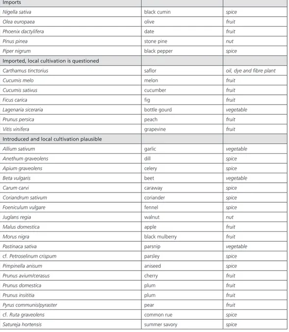
Archaeobotanical research by the University of Basel during the excavation of Oedenburg revealed a highly di-versified flora (Vandorpe & Jacomet 2011). Beside the woodland of the wet valley bottom of the Rhine floodplain are various hardwood taxa that might come from the alluvial terraces of the site or the piedmont areas (fir). But the most remarkable feature is probably the suite of cultivated plants, reflecting in part the changes made in Roman times and the import and then local acclimatisation of new species of Mediterranean origin (fig. 12).
Cereals are mostly spelt, emmer and, to a lesser extent, einkorn. The free-threshing wheat and other cereals appear more marginally, apart from barley, the presence of which is hardly surprising in a military camp that had to maintain a number of horses and mules. The question is whether these various cereals were already cultivated on the spot before the military arrived or whether on the contrary their culture required, when the troop first settled, a vast operation of deforestation, especially of the alluvial terraces on the right bank or whether, as a third hypothesis,
Grussenheim Oedenburg Riegel Horburg-Wihr Colmar/Fronholtz Niederhergheim Breisach «Staatackern» ? Umkirch Bad Krozingen Settlement Villa /cemetery isolated find Road Supposed road Heiteren ?
- 12
RurLand
Ferrette Colmar Belfort Saint-Dié Bâle Strasbourg Sélestat Marckolsheim Freiburg Oedenburg Villé Neuf-Brisach Mulhouse Doller Lauch Fecht Rhin Rhin Kinz ig Meur the Ill Bruche Thur Ill Sarre Elz Lar gue Giessen Sundgau 1247 m 250 m 811 m Hardt KAISERSTUHL 559 m 137 m JURA Ried rhénan Ried centr e-alsace VOSGES CRISTALLINES ET SOCLE HERCYNIEN FORÊT NOIRE 178 m Wet areas Dry, sandy areas Pebbles Loess Volcano (Kaiserstuhl) Sediments Hills Bedrock 20 km 0N
+ Fig. 11. Simplified geological map of the Rhine graben in Alsace and Bade (V. Ollive / Ch. Petit).
13
-they were imported to feed the garrison at least when the site was first occupied. In the first instance, the hypothesis presupposes the presence of a local farming population of which, it has been said, no trace has been found to date at Oedenburg itself. However, there is better evidence of such presence on the lower slopes of the Kaiserstuhl from the end of La Tène. It must not be considered, in this respect, that the Rhine was an uncrossable barrier and that the presence of a garrison on the left bank prohibited settlement of the right bank for cultivation or exploitation. Apart from the various testimony of the economic exploitation of the zone ahead of the official ‘frontier’ in Roman times (Tacitus, Ann. XIII, 54), various archaeological studies have revealed that the Bade plain, on the right bank, was ex-ploited from an early date, well before it was officially annexed (Asskamp 1989).
This hypothesis seems to me more credible than any massive deforestation of huge swathes of the left bank, which a priori were not good farmland without soil enrichment and manuring and would not have been very pro-ductive in the short term. However, it does not exclude the importing of cereals over greater distances, from within Gaul, as observed for the beginning of the Roman period (Reddé 2011b). In other words, thinking about the agrarian economy of the site must be extended to a far wider area than the site itself and take into account the right-bank of the Rhine but also long-distance connections.
Imports
Nigella sativa black cumin spice Olea europaea olive fruit Phoenix dactylifera date fruit Pinus pinea stone pine nut Piper nigrum black pepper spice
Imported, local cultivation is questioned
Carthamus tinctorius saflor oil, dye and fibre plant Cucumis melo melon fruit
Cucumis sativus cucumber fruit Ficus carica fig fruit Lagenaria siceraria bottle gourd vegetable Prunus persica peach fruit Vitis vinifera grapevine fruit
Introduced and local cultivation plausible Allium sativum garlic vegetable Anethum graveolens dill spice Apium graveolens celery spice Beta vulgaris beet vegetable Carum carvi caraway spice Coriandrum sativum coriander spice Foeniculum vulgare fennel spice Juglans regia walnut nut Malus domestica apple fruit Morus nigra black mulberry fruit Pastinaca sativa parsnip vegetable
cf. Petroselinum crispum parsley spice Pimpinella anisum aniseed spice Prunus avium/cerasus cherry fruit Prunus domestica plum fruit Prunus insititia plum fruit Pyrus communis/pyraster pear fruit
cf. Ruta graveolens common rue spice Satureja hortensis summer savory spice
table 5 Overview of the newly introduced and imported food plants recorded in Roman Oedenburg.
plants which can and those which can not grow north of the alps. species belonging to the last group require different climatic conditions and were thus certainly imported. Species belonging to the first group could grow in alsace meaning the climatic conditions do not prohibit their growth (they may however be damaged by cold winters or late frosts).
- 14
RurLand
A number of other plants found at Oedenburg or in its immediate vicinity were probably grown in the gardens of the agglomeration that were developed from the middle of the first century of our era, or in its immediate vicinity: le-gumes, spices, salads, vegetables and fruit. However, again a distinction needs to be made between the pioneering period of human settlement when Mediterranean products were necessarily imported, and the later development after the military had left and when allogenous taxa could have become acclimatised.
The third fundamental component of the flora at Oedenburg was the grassland plants, both cultivated and natu-ral varieties (fig. 13). Cultivated plants fared well on the wet valley bottom soils. Wild varieties thrived on the alluvial terraces close to the site. Both are found in the samples analysed, attesting to the local fodder production practices from the beginning of Roman times and of livestock farming required for agricultural practices and for feeding the population. It must be imagined there was meadowland in the immediate vicinity of the agglomeration or marginal grassland on the cleared, pebbly soils.
Discussion
Reconstructing the geographical environment of an archaeological site is not just a mapmaking exercise. It re-quires sufficient information of very varied kinds to suggest thinking more akin to modelling than the representation of a real space, especially when one has, on a micro-regional scale, just one point of reference that cannot be com-pared with others as is the case here. I propose, then, by way of conclusion, an interpretative scheme for the begin-ning of the Roman era (fig. 14). I am aware of how many assumptions it contains but it seems to me that it reflects the current state of our yet limited knowledge of the site and its region. It shows the existence of different zones that take account of the agricultural potential of the soils around Oedenburg, on the left and right banks alike. To achieve a finer analysis, other more numerous data, on the scale of the terroir, would be necessary. It would also be useful to match this information with archaeo-zoological data, which has not been attempted as yet. Moreover, in the case of a frontier agglomeration like Oedenburg, one must wonder about the connections with its hinterland to understand the role of the various sectors of activity and their interactions. This large market town was not just a small regional capital with what might be termed ‘quasi urban’ functions (communications node, political and religious centre, local economic capital, centre for consumption and redistribution of produce). It also had its own productive capabilities, which were not just artisanal and agricultural output. The question of the economic complementarity between the rural environment in the medium distance and the immediate periphery of the agglomeration with its gardens or nearby fields must be asked. They may have been sufficient to feed a population that no parameter allows us to es-timate with an acceptable margin of error. But we know next to nothing of the countryside around Oedenburg and it
P. Vandorpe, S. Jacomet · Plant Economy and Environment
58
Summary
indications for agricultural practices in and around roman oedenburg are numerous (tab. 4). cereal cultivation played an important role in the local agricultural system. study of the arable weeds suggests that cereal fields were located on the calcareous gravel terraces along the Rhine as well as on the nutrient-rich loamy and sandy soils in the near vicinity of the settlement. although local cultivation of cereals is evident, import of cereals can not be excluded. Whether this was a single event at the beginning of the Roman occupation in oedenburg or a continuous event throughout its occupation is hard to verify. in and around the settlement small garden plots were operated for the cultivation of mainly vegetables, spices and possibly fruit trees. Besides cereal fields and gardens, it is thought that meadows and pastures were located in the near vicinity of the settlement, the plant remains indicate their management.
roman introductions and imports
at the beginning of the roman period many new food plants are introduced north of the alps, many of which are also found in roman oedenburg 131. in Table 5 the newly introduced and imported food plants
found in the studied samples are summarised. In this table we differentiate in the first place between those
131 these food plants have been the subject of a previous publication,
therefore we only briefly touch upon this issue; see P. vandorpe
/ s. jacomet 2005 in m. reddé et al. oedenburg (footnote 39), 252-257.
molinio-arrhenatheretea Achillea millefolium 6.-9 Nardus stricta* 5.-7
cultivated meadows and pastures Agrostis sp. 6.-8 Plantago lanceolata 4.-9 Bromus cf. commutatus 5.-6 Plantago media 5.-7 Bromus hordeaceus 5.-6 Poa pratensis 5.-6 Centaurea sp. 6.-9 Potentilla erecta 6.-9 Dactylis glomerata 5.-6 Prunella vulgaris 6.-9 Deschampsia caespitosa 6.-8 Ranunculus acris 4.-9 Festuca rubra/ovina 5.-9 Rhinanthus sp. 5.-8 Holcus lanatus 5.-8 Rumex acetosa 5.-8 Leontodon autumnalis 7.-9 Silene vulgaris 6.-9 Leucanthemum vulgare 5.-10 Taraxacum officinale 4.-10 Lolium perenne 6.-9 Trifolium pratense 5.-10
festuco-brometea Dianthus sp. 5.-10
moor or less arid poor calcareous swards Medicago lupulina 5.-9 Medicago minima 5.-6 Odontites sp. 6.-10 Prunella grandiflora 6.-10 Scabiosa columbaria 6.-9 Trifolium cf. campestre 5.-8
table 4 Grassland taxa recorded in Pit BK 99-04-01 indicating blooming times of each taxon (indicated by month 1 to 12).
may even be wondered to what extent the Hardt had been cleared at the time. This gap precludes us from proposing any really credible model of the human settlement and agricultural output in Roman times on this frontier.
In conlusion one must outline the chronological change in the environmental factors that markedly altered be-tween the beginning of the era and the end of Antiquity. These factors themselves were determined in part by man, at what is not a uniform historical pace. A potential proto-historic period but that is still unknown; a Roman military phase that might have had a major impact on the environment, but this is still to be proved with any certainty; a long entirely civilian settlement followed by re-militarisation in the course of the fourth century. The ‘frontier’ phenomenon in this sector at least cannot be apprehended by simple mechanical schemas inherited from a classical conception of the frontier as a military barrier.
References
Asskamp, R., 1989. Das südliche Oberrheingebiet in frührömischer Zeit. Forsch. u. Ber. Baden-Württemberg 33. Stuttgart. Bender, H. & Pohl, G., 2005. Der Münsterberg in Breisach I, Römische Zeit und Frühmittelalter karolisch-vorstaufische Zeit. München.
Cavallo, Ch. & Kooistra, L. I., 2008. Food supply to the Roman army in the Rhine Delta in the first century A.D. in eds. S. Stallibrass & R. Thomas, Feeding the Roman Army. The Archaeology of Production and Supply in NW Europe, Oxford, 69-81.
Blöck, L. & Bräuning, A., 2012. Der spätlatènezeitliche Siedlungslandschaft am südlichen Oberrhein in L’âge du Fer entre
la Champagne et la vallée du Rhin. Die Eisenzeit zwischen Champagne und Rheintal. 34e Colloque international de l’Asso-ciation française pour l’Âge du Fer (13-16 mai 2010, Aschafenburg), eds. M. Schönfelder, S. Sievers: RGZM-Tagungen 14, Mainz, 381-418.
Habermehl D., 2013. Settling in a changing world. Villa development in the Northern provinces of the Roman Empire, Amsterdam University Press.
gardens meadows KAISERSTUHL HARDT (Pebbles) Forest ? Cultivated area LOESS
+ Fig. 14. Theoretical schema of the agricultural production zone around Oedenburg (M. Reddé).
- 16
RurLand
Kooistra, L.I., 1996. Borderland Farming. Possibilities and Limitations of Farming in the Roman Period and Early Middle
Ages between the Rhine and the Meuse. Amersfoort : ROB.
Kooistra L.I. & Van Dinter M., 2013. Could the local population of the Lower Rhine delta supply the Roman army. Part 1?
Journal of Archaeology in the Low Countries 4-2, 5-23.
Reddé, M., 2009 (ed.). Oedenburg I. Fouilles françaises, allemandes et suisses à Biesheim et Kunheim, Haut-Rhin, France.
Les camps militaires julio-claudiens. Monographien RGZM, 79-1. Mainz, 2009.
Reddé, M., 2011a (ed.). Oedenburg II. Fouilles françaises, allemandes et suisses à Biesheim et Kunheim, Haut-Rhin, France.
L’agglomération civile. Monographien RGZM, 79-2. Mainz.
Reddé, M., 2011b. “Ut eo terrore commeatus Gallia aduentantes interciperentur” (Tacite, Hist. V, 23). La Gaule intérieure et le ravitaillement de l’armée du Rhin. REA 113, 489-509.
Seitz G., 2003. Villen, Vici, Bäder: die römische Besiedlung des rechten Rheinufers in Kelten, Römer und Germanen: frühe
Gesellschaft und Herrschaft am Oberrhein bis zum Hochmittelalter. Freiburger Universitätsblätter, 159, 47-63.
Roymans N., 2014. Re-assessing the transformation of rural society in the Roman Rhineland in ed. D.J. Breeze, The Impact
of Rome on the British Countryside. A conference organized by the Royal Archaeological Institute, Chester, 11-13 October 2013, The Royal Archaeological Institute.
Roymans N. & Derks T, 2011 (eds.). Villa Landscapes in the Roman North : economy, culture and lifestyles, Amsterdam University Press.
Van Dinter M. & Kooistra L.I., 2014. Could the local population of the Lower Rhine delta supply the Roman army. Part 2?
Journal of Archaeology in the Low Countries 5-1, 5-50.
Vandorpe, P. & Jacomet, S., 201. Plant economy and environment. in Reddé 2011a, 2, 3-72.
Wendling, H., 2012. Der Münsterberg von Breisach in der spätlatènezeit: Siedlungsarchäologische Untersuchungen am Oberrhein. Materialhefte zur Archäologie in Baden-Württemberg, 94, Stuttgart.