HAL Id: halshs-00463620
https://halshs.archives-ouvertes.fr/halshs-00463620
Submitted on 13 Mar 2010HAL is a multi-disciplinary open access archive for the deposit and dissemination of sci-entific research documents, whether they are pub-lished or not. The documents may come from teaching and research institutions in France or abroad, or from public or private research centers.
L’archive ouverte pluridisciplinaire HAL, est destinée au dépôt et à la diffusion de documents scientifiques de niveau recherche, publiés ou non, émanant des établissements d’enseignement et de recherche français ou étrangers, des laboratoires publics ou privés.
Inter-Korean maritime dynamics in the Northeast Asian
context
César Ducruet, Stanislas Roussin
To cite this version:
César Ducruet, Stanislas Roussin. Inter-Korean maritime dynamics in the Northeast Asian context: Peninsular integration or North Korea’s pragmatism?. North / South Interfaces in the Korean Penin-sula, Dec 2008, Paris, France. �halshs-00463620�
Inter-Korean Maritime Dynamics in the Northeast Asian Context
Peninsular Integration or North Korea’s Pragmatism?
Draft paper
International Workshop on “North / South Interfaces in the Korean Peninsula” EHESS, Paris, December 17-19, 2008
César DUCRUET1
Centre National de la Recherche Scientifique (CNRS) UMR 8504 Géographie-cités / Equipe P.A.R.I.S. 13 rue du Four F-75006 Paris France Tel. +33 (0)140-464-000 Fax +33(0)140-464-009 Email: [email protected] Stanislas ROUSSIN
General Manager & Head of Research Department SERIC COREE
1302 Byucksan Digital Valley V 60-73 Gasan-dong, Geumcheon-gu Seoul 153-801 Republic of Korea Tel: +82 (0)2-2082-5613 Fax: +82 (0)2-2082-5616 Email: [email protected]
Abstract. Although nowadays inter-Korean trade is primarily shipped by sea, very limited attention has been paid to the specific role of maritime transport in inter-Korean relationships. Based upon a 20-year database of daily vessel movements, this paper relates the changing geography of inter-Korean connections with the evolution of the North Korean economy and territory. Main results show the convergence between inter-Korean economic cooperation and shipping growth. South Korean ports also provide a logistics platform facilitating North Korea‟s transit trade with the rest of the world. The convergence or divergence between economic integration and hub dependence are discussed and provide a base for further research.
1. INTRODUCTION
Understanding the nature and implications of inter-port connections does not only lack in the case of the two Koreas, but it also represents a challenge for wider academic studies on the geography of maritime transport. Through their vital role as transport nodes ensuring commercial flows between regions and nations, ports are key propellers of political and cultural influences. Even for supposedly continental or closed nations such as the former USSR, maritime transport has continuously been given increased importance not only for geopolitical but also for economical purposes. Therefore, the intensity, pattern, and evolution of port activities and maritime networks constitute a very useful looking glass for the analysis of wider changes in a country‟s relations with the outside world. Referring to the works of geographers, spatial
integration can be defined as “the setting of a tighter interdependence among the elements of a
group” or as “the incorporation of new elements within a group”. This research proposes to verify to what extent the changing geography of inter-Korean maritime linkages verifies this concept or if it is influenced by wider trends occurring within North Korea itself or on a broader scale such as Northeast Asia and the world along the last two decades.
Nowadays, inter-Korean trade depends for 90% on maritime transport, due to the barrier constituted by the Demilitarized Zone (DMZ) between North and South. Such importance has motivated recent research2 about the content and evolution of such relations. Data analysis of daily vessel movements3, which allowed for distinguishing inter-Korean trade from North Korean transit trade passing through South Korean ports, demonstrated that inter-Korean shipping oscillates between economic integration (trade) and hub dependence (transport). Moreover, the geography of inter-Korean maritime networks over the last two decades not only closely matches North Korea‟s broader evolution externally (i.e. geopolitical changes such as USSR collapse and decreased trade with Japan), but it reveals to what extent internal dynamics also affect the origin and destination of the flows (e.g. industrial decline of Eastern cities and limitations of the domestic transport system; westward shift of populations and activities around the Pyongyang area; concentration of the North Korean port system at Nampo, the gateway of the core economic region). Despite the absence of a peace treaty, recent changes on the Korean peninsula, such as shipping liberalization and growing economic cooperation through political dialogue, call for the revisit of the role of inter-Korean shipping in North Korea‟s development and in broader issues of regional integration.
2 see selected references
The remainders of the paper are organized as follows. First, a historical background on port development on the Korean peninsula is proposed for introducing the long-term pattern. Second, a review of available data sources lists the possible indicators used for the multi-scalar analysis, and introduces preliminary results on the evolution and geography of inter-Korean shipping. Third, a factor analysis is applied to the evolution of local, regional, and global maritime traffic between 1985 and 2005. Conclusive remarks close the research and open the floor for further discussion about the dichotomous role of maritime transport in enticing inter-Korean economic and territorial integration.
2. BACKGROUND ON INTER-KOREAN MARITIME DYNAMICS
2.1 SHORT HISTORY OF PORT DEVELOPMENT ON THE PENINSULA 2.1.1 PORT DEVELOPMENT BEFORE 1945
Due to active trade activities with Japan and the Korean East coast, the Kaya confederation is the most dynamic during the Three Kingdoms era (37BC-10th c) compared with Shilla, Paekje, and Goguryeo kingdoms. The annexion of Kaya by Shilla allows better access to the West while improving relations between Korean elites and China. The main maritime routes are developed from Wonsan to Japan and from Pyongyang and Hwanghae province to China4. Further expansion of maritime trade occurred westward from Nanju and Namyang with the expansion of Korean fleet, establishment of Korean quarters in Chinese ports (e.g. Shandong, Liangshui, Yangzhou and Chuzhou) where Arab and Korean merchants interact, and eastward, through further territorial expansion towards Primorsky, but persisting internal riots provoked a temporary decline of maritime trade in general.
New routes5 are opened under the Goryeo era (10th-14th c) between Chinese ports and Byeokrando, the port of the bustling capital city of Gaeseong. The Yaeseong River at that time is the most dynamic gateway of the peninsula where Arab merchants anchor regularly. However, the Mongol invasions (1231-1368) that required numerous Korean ships in the attempts invading Japan and the Japanese piracy (Wako) originating from Tsushima island hampered further development of Korean ports. During the following Choseon era (1392-1910), an important set of
4 Such relations occurred formally through embassies, backed by the development of Korean craftwork (e.g. gold and
silver vases, copper products, and brocades) exported to China in exchange of pearls, fans, folding screens, books, pieces of lacquerware, and weapons.
5 Maritime trade under Goryeo period is much based on rice transport that is the base of food and taxation. Goryeo
exports gold, silver, copper, ginseng, ink, and paper in exchange of importing silk, books, medicines, and spices predominantly from China.
reforms is achieved for modernising and developing the country, but internal struggles for power, the lack of mercantile culture of the elites, and the Japanese and Manchu invasions6 also limited port development.
The modernisation of Korean ports occurs with the Treaty of Ganghwa (1876) in a context of repeated pressures from American, German, French, British, Russian, and Japanese merchants. Busan, Incheon, and Wonsan ports are opened to foreign trade; a governmental office in charge of maritime transport is created in 1886 purchasing steamships for rice transport. Before the creation of chambers of commerce in 1905, Korean traders and wholesalers were developing rapidly at port cities despite competition from Japan and reluctance of Korean elites for maritime trade. Despite the opening of Nampo (1897) and Haeju (1906) ports, and the strategic position of Incheon and Busan for Japanese entry into the continent, port expansion occurs dominantly in the northeast of the peninsula. On the one hand, southern ports receive much foreign investments in terms of telecommunications, railway connections, and coal depot construction by Japan, Russia, and the United States. The domination of Japan is made evident from 1905 with the seizure of Korea‟s transportation and communication facilities7
. On the other hand, north-eastern ports such as Cheongjin (1908) are better located for plundering northeast Chinese and Korean resources. Railway links from Wonsan to Pyongyang and Shenyang (China) are developed in 1914. During the Japanese invasion (1910-1945), Korea becomes a relocation area for Japanese industries willing to reduce their costs, notably from the early 1920s, because Korea possesses a half cheaper labor force and abundant hydroelectric energy. The eastern part of the peninsula attracts most port facilities and port-related industries (e.g. fertilizer factory in Hungnam), notably due to the war effort towards Manchuria supported by the zaibatsu.
6
The Japanese attempts invading the peninsula were countered by the Korean warships that are the first battleships throughout history. Despite the ravagers on the south coast, Korean traders remain dynamic inserting Gaeseong, Uiju (i.e. Sinuiju), and Tongnae (i.e. Busan) in a triangular trade based on Korean red ginseng, Japanese copper, and Chinese money. After the lightning strikes of Manchu invasions in 1627 and 1637, the decline of Choseon begins while it embarks on isolating itself as the „Hermit Kingdom‟. From this period the Korean coasts are left undeveloped avoiding the attraction of foreign invaders, while contacts between China and the ultra-conservative and neo-confucianist elite occur through embassies.
7 Notably, the accordance and extension of fishing rights to Japan in 1888 and 1891 lead to the dominance of the
latter in the traffic of Korean ports (i.e. 956 among 1322 vessels, 78% of total tonnage in 1893), while in 1898, 210 companies among the 258 foreign trading firms located in Incheon, Busan, and Wonsan are Japanese. This dominance is also explained by investments made by the zaibatsu in the mining sector (e.g. coal, iron, lead, tungsten, magnesite, silver, graphite, and molybdene) from which a part of the production was eventually sold to the Allies during the First World War.
2.1.2 PORT DEVELOPMENT AFTER 1945
During the Korean War (1950-1953), many port sites were heavily damaged8. In the end, 18 among 22 main North Korean cities were almost deleted from the map, of which Hamheung and Heungnam (80-85%), Sariwon (95%), Nampo (80%), and Pyongyang (75%). Notably, Heungnam served as a site for a major evacuation of 200,000 U.N. military and North Korean civilians by merchant and naval ships to Busan in South Korea. While Heungnam hosts a large fertilizer complex for chemical weapons and possessed Asia‟s first cyclotron in the 1940s constructed by the unsuccessful Japanese atomic program, it was seized by the Soviet army in 1945. Through the successive State plans however, the North Korean economy was brought back to pre-war levels, and further growth made this country East Asia‟s second industrialized nation in the 1960s. However, its dynamism faltered in the 1970s and started to collapse in the 1980s due to tense international relations among socialist countries and the limitations of the centrally planned economy in reaching further productive potential.
During the Cold War, the North Korean transport system is developed under Soviet and Chinese influence. As in other socialist countries, limited international trade hampered the development of ports and airports, although the ambition of former President Kim Il-Seong was to create a “fully integrated containerized transport system” through the 7 year Development Plan (1961) destined “to ensure coastal transport, expand railway connections and, in particular, improve foreign trade using our ships.” Those plans fell short in the mid-1970s, and apart the creation of Rajin port in 1974, port infrastructures were not upgraded except from some oil berths and storage facilities. Thus, the story of North Korean ports since then closely follows the wider trend of limited foreign trade, deterioration of infrastructure and capital stock. While the application of socialist theory to regional planning allowed balanced economic development within the country, the reliance on heavy industries and military control prevented the emergence of competitive advantage in the world economy. Two main trends have affected port development in North Korea more recently. On the one hand, several other factors have led to the decline of transport infrastructures in this country, notably in the case of ports:
Trade embargo: since 1996, North Korea is under trade embargo that directly impacts negatively on the activity of its ports. For instance, production realized by Chinese and South Korean (e.g. Gaeseong Industrial Park) companies in North Korea bypass this difficulty through re-exports across the border.
8 It is estimated that about 800 tons of napalm bombs were dropped each day on North Korea in the end of August
1950 by US aircrafts, for a total of 3.2 million litres of napalm between June and October (Cumings, 2004). Aerial raids launched 500, 550, and 700 tons of bombs on Heungnam, Sinuiju, and Pyongyang respectively in one day.
This explains why 80% of North Korea‟s exports pass through Sinuiju-Dandong and why Gaeseong‟s production is labeled as South Korean products after crossing the DMZ.
Economic crisis: the lasting economic crisis and lack of capital prevents North Korea from investing in infrastructure maintenance and renovation. As a result, only 7% of roads are paved, railways cannot run on a regular basis due to lack of electricity (the railway system is 70% electrified), and the nautical accessibility of port entrance channels decreases regularly due to the lack of dredging equipments. As a result, most cargoes are handled by hand at the docks, due to the lack of adequate cargo handling facilities such as cranes and forklift trucks.
Ideological and military control: as in former socialist countries, maritime transport is not a top priority compared to land transport. For instance, the army focuses more on the development of highways for defense purposes while ports are seen as dangerous entry points of external influences. Therefore, shipping to North Korean ports represents excessive costs (i.e. port entry fee, special permit to foreign vessels). The dominance of bulky products and the preferential border trade with China and Russia also tend to lower the importance of ports in the North Korean economy.
Thus, North Korean ports remain largely underdeveloped (Figure 1), but it is likely that their role will increase in the future due to the dereliction of other transport systems in North Korea. In addition, ports are well located to serve the dominantly coastal urban system. Roads and railways are increasingly unable providing sufficient east-west and north-south connectivity within the country. On the other hand, several ongoing dynamics indicate an important turn in the role of ports in this country due to the growing involvement of external players:
China: the most recent port developments in North Korea seem to be financed by China, as seen in Nampo (new container terminal, Songgwan bulk terminal) and Rajin (leasing for 50-80 years of container terminals). In addition, the improvement of the road link between Rajin-Seonbong and Hunchen city is underway, parallel to the development of the Namyang Logistics-Free Zone at the northeastern border with China, notwithstanding the announcement of the creation of the Bidan-Wihwa Free-Trade Zone at the western border. This echoes wider trends of China‟s growing involvement in the North Korean economy.
Japan: the regular ferry link between Wonsan and Niigata has been officially interrupted by Japanese authorities since the ban of North Korean vessels from Japanese ports due to illegal activities. Although Japan was one main investor in the Rajin-Seonbong Free-Trade Zone project at early stage, it seems that it has not much been involved in the upgrade of the land bridge connection.
Russia: recent information confirms the Russian strategy providing Rajin-Seonbong with electricity and improved railway access to the Siberian gas fields. This remote location is thus the focus of converging Sino-Russian interests.
Figure 1: Location, size, and nautical accessibility of Korean ports around 2005
Sources: realized by authors based on various sources
South Korea: although South Korean authorities such as KCTA (Korea Container Terminal Agency) have failed in developing North Korean ports (e.g. container freight station in Nampo, inter-Korean hub in Heungnam, cruise and ship repair in Wonsan), they have succeeded in liberalizing inter-Korean
shipping. In 2004, an inter-Korean maritime agreement9 was signed, and in 2005 a regular shuttle has started to operate between Incheon and Nampo. However, the ambitious project to develop a new industrial park in Haeju port following the second inter-Korean presidential summit (2007) has not been implemented yet.
Others: some industrial projects underway may indirectly foster port renovation, such as mine exports from Danchon in the East, and increasing foreign investment along the Nampo-Pyongyang corridor (e.g. European, Chinese, and Egyptian companies involved in manufacturing and mining activities).
2.2 THE EVOLUTION OF INTER-KOREAN SHIPPING
2.2.1 DATA SOURCES AND METHODOLOGY
While this research synthesizes numerous and dispersed information from economic intelligence reports, governmental papers, worldwide directories, newspapers, professional websites, and working papers from various countries and scholars, detailed data on maritime transport remains very scarce. Trade data from Korean sources is limited to aggregated figures by commodity, regardless of the modal split (e.g. South Korean Ministry of Unification, Bank of Korea, and Korea Trade Investment Promotion Agency, KOTRA). Non-Korean organizations or researchers give estimates of the modal split of domestic traffic in North Korea or about total traffic capacity and infrastructural characteristics of North Korean port, but this is limited to one year only. Some time series on North Korean sea transport can be collected from the International Road Transport Union until 1990, and from the Korea Maritime Institute until 2020 but such figures are mostly estimations. Finally, the South Korean Ministry of Unification provides some statistics on the number of ships moving between the two Koreas, but it is limited to inter-Korean shipments, and ignores the rest of North Korea‟s port activity. Because North Korean ports are controlled by the army, there is no information on their activity in official sources, except from unrealistic figures provided by the Korea Central News Agency (KCNA), notably about Rajin port10.
The lack of long-term and precise data on inter-Korean shipping can be overcome by using the information provided by Lloyd‟s, the world leader in shipping insurance and economic intelligence. Its global database captures about 80% of the world fleet, providing information
9 This agreement declares inter-Korean sea lanes as national sea lanes for both countries, opens new sea lanes
between respective ports (i.e. Incheon, Gunsan, Yeosu, Busan, Ulsan, Pohang, and Sokcho in South Korea; Nampo, Haeju, Goseong, Wonsan, Heungnam, and Rajin in North Korea), and states that both Koreas should cooperate in the case of ship wreckage while treating respective ships identically within their ports.
10 For instance, a recent press announcements made by the KCNA evaluates Rajin port‟s traffic about 300 million
between 1985 and 2006 about the daily effective movements of vessels between ports, along with the characteristics of the vessels (e.g. capacity in DWTs11 and TEUs, flag, shipowner, date of build, type and subtype). The manipulation of data thus provides port-based or inter-port based statistics on traffic that can be used to assess port and network evolution and performance, in terms of number of calls, total capacity circulated, number of vessels, average vessel size, average berthing time at the docks, share of different shipping line nationalities, share of difference commodities (e.g. bulk, general cargo, vehicle, and containers).
2.2.2 PRELIMINARY RESULTS
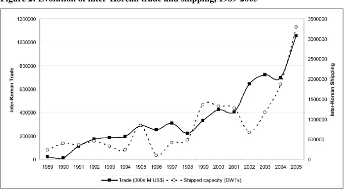
Applying such methodology to inter-Korean shipping provides useful evidence about its overall and geographical evolution during the last two decades. First, the comparison of trade and shipping evolution between the two Koreas since 1989 reveals a good match despite few exceptions (Figure 2), due to the fact that shipping statistics, unlike trade statistics, are not measured by the value of goods shipped. For instance, the circulated shipping capacity is higher than trade volume because of tanker traffic, both in 1989-1990 (Wonsan-Ulsan) and in 1999-2001 (humanitarian support and KEDO project). The opposite case occurs when shipping is used for „real‟ trade, notably for the period 2002-2004 following the inter-Korean summit.
Figure 2: Evolution of inter-Korean trade and shipping, 1989-2005
Sources: drawn by authors based on KOTRA and LMIU
11 DWT: Deadweight Tonnage or commercial capacity of a vessel; Twenty-Foot Equivalent Unit, measures the slot
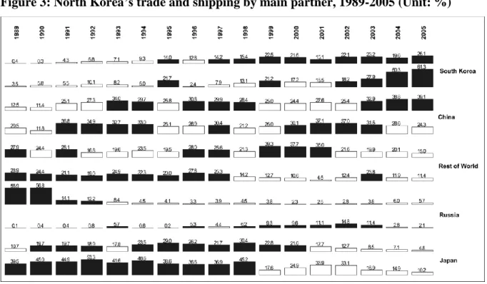
Second, expanding the analysis to other key trade partners of North Korea highlights the contrasted role of shipping between the countries (Figure 3). It seems that South Korea concentrates an increasing and dominant share of North Korea‟s maritime connections (61% in 2005) while it occupies only 25% of North Korea‟s international trade. This may be explained by the blockage at the DMZ and by the comparatively lower value of inter-Korean shipments stemming from the high proportion of humanitarian aid and low-valued goods (e.g. textiles, minerals). For other partners, the share of shipping is usually lower than the share of trade, except for Japan due to the island effect but both figures are rapidly declining following the banning of North Korean ships from Japanese ports12. For China and Russia, most trade occurs inland through the border cities of Sinuiju and Rajin, and it involves higher valued-goods such as manufactured products, reflecting the increasing influence of China on the North Korean economy.
Figure 3: North Korea’s trade and shipping by main partner, 1989-2005 (Unit: %)
Sources: drawn by authors based on KOTRA and LMIU
N.B. for each country, the upper row is the share in North Korea‟s international trade (% $US), while the lower row is the share in North Korea‟s immediate maritime connections (% DWT); dark colours indicate values higher than the rows‟ average value.
12 The missile incident of 1998 caused political tensions and the cease of the regular ferry link between Wonsan and
Niigata. This situation was also aggravated by the accusation of North Korea by Japanese authorities to kidnap Japanese women during their anchorage.
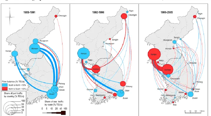
Third, the geographical distribution of inter-Korean shipping along three main periods is a necessary complement to the evolution of aggregated figures (Figure 4). The three periods may be explained as follows:
1985-1991: before the collapse of the USSR and the socialist block, inter-Korean shipping concentrates on the east coast of the peninsula, and is dominated by south-north dynamics. Few ports ensure the connections, namely Nampo-Busan in the west and Wonsan-Busan-Ulsan in the east. The importance of Wonsan and southeast ports is easily explained by the dominance of oil shipments between the main coastal petrochemical complexes. Western ports are not much dynamic due to sustained political tensions on the peninsula and because of frequent naval encounters on the Yellow Sea near the Northern Limit Line (NLL).
1992-1998: there is a drastic shift to the west coast of the main shipping flows compared to the previous period. Nampo concentrates most connections with South Korean ports, among which Incheon has become the leading port. Yet, Busan and Ulsan keep their role as important pivots but in North Korea only Cheongjin handles substantial traffic volumes. Overall, traffic routes have become more diverse, and the number of ports connected is higher than during the previous period. Such reversal may have been caused by a more pragmatic attitude of the North Korean regime vis-à-vis South Korea at a time of geopolitical isolation and economic decline. In addition, the balance of flows between north and south has become more balanced compared to the previous period.
1999-2005: while one can observe a continuation of the previous trend in terms of increased number of links and ports, there is a considerable concentration of traffic between Incheon and Nampo, the natural gateways of the two respective capital cities and core economic regions, Seoul and Pyongyang. From a dominantly south-north first period, the current situation is now inverted with a dominant north-south flow. Thus, there is a shift from east to west and from south-north to north-south during the last two decades. It is highly probable that this directly stems from improved relations and economic cooperation efforts between the two Koreas, in a context of reform and openness in the North.
The changing geography of inter-Korean maritime connections possesses several symptoms of ongoing integration of the peninsula. The multiplication of links and ports connected, in addition to the growth of overall volume, are perfect indicators of spatial integration. On the one hand, the implementation of the maritime agreement and the economic cooperation efforts seem to be translated spatially with clear evidence. On the other hand, the two
Koreas remain constrained in their efforts by war risk, trade embargo, and multiple internal and external pressures, forcing trade flows to take place on sea rather than inland. Given such difficulties (that also hamper any serious cooperation in port development), two main questions are inevitable before going further, asking whether it is possible:
to define the observed trend as a process of integration?
to observe spatial integration without political or economical integration?
In order to better situate such dynamics within the broader North Korean and Northeast Asian context, next section will compare the inter-Korean trend with the evolution of trade and other shipping connections.
Figure 4: Geographical evolution of inter-Korean maritime connections, 1985-2005
Source: realized by authors based on LMIU
3. INTER-KOREAN SHIPPING WITHIN NORTH KOREA’S CONNECTIONS
3.1 GENERAL TRENDS
A factor analysis allows for comparing the evolution of inter-Korean shipping with the shipping connections of North Korean ports in general. Within the study period, groups of years
can thus be defined by common attributes13. Three main factors concentrate about 63% of the original information, which characteristics are synthesized in Table 1 and interpreted as follows:
Global pipeline vs. Crisis & isolation (F1): at times of efficient insertion within the global economy, inter-Korean shipments are relegated to liquid bulk (oil) shipments. Other products (general cargo, bulk) pass through long-distance trades, connecting North Korea‟s major industrial poles (East coast) to the rest of the world for which European shipowners ensure the circulation. Oppositely, inter-Korean shipping is closely related to crisis and the isolation of North Korea. Local shipowners (Russia, China) ship containers along the West coast, while in North Korea, the fleet is ageing and only smaller ports perform better than average (Haeju, Songjin). This factor indicates that inter-Korean dynamics take place as a remedy to the difficulties of the North Korean economy.
Hub dependence vs. Socialist trades (F2): the role of South Korea in ensuring North Korea‟s connection with the rest of the world during the recent period is made evident by the combination of North Korea‟s difficulties (ageing fleet, contraction of forelands within Northeast Asia), and the prime importance of South Korean shipowners for supporting the import of containers and general cargo by both coasts simultaneously. Thus, North Korea needs the South Korean hub for accessing other regions through maritime networks. The opposite trend shows that during the years just preceding and following the USSR collapse, North Korea‟s international trade was much fostered by the Eastern industrial poles connected to brother countries in South Asia, Africa, and Eastern Europe. In this pattern, inter-Korean shipments are not existent.
Humanitarian aid vs. Foreign investments (F3): the trend of humanitarian aid is clearly identified by the interplay of tanker traffic, originating from the US gulf coast and channelled by US shipowners towards Nampo, Pyongyang‟s gateway, through direct connections of which South Korean ports (liquid bulk). The opposite trend reveals the complementary role of South Korea. On the one hand, Rajin dominates because of the launch of the free-zone project in 1991. On the other side, South Korean shipowners provide containers, bulk, and general cargo to North Korean ports for supporting the development of South Korean projects (Kaeseong, Kumgang) at the border area, in a context of liberalized maritime transport notably after the 2004 agreement.
Table 1: Main results of the factor analysis
Factors F1 F2 F3 F4
Cumulated variance
(%) 35.3 56.3 63.2 68.4
Eigenvalues 21.9 13 4.3 3.2
Interpretation Global pipeline Hub dependence Humanitarian aid -Years concerned 1985-1991;
1999-2001; 2005 1999-2005 1997-1999; 2000-2002
1997; 2005; 1994; 1986; 1991; 1987 DPRK general trend Total connections,
International trade
Total calls, AVG vessel
age Direct connections Direct connections DPRK most
connected ports
East coast, Heungnam, Cheongjin
Songjin, West coast,
Nampo, Haeju Nampo
West coast, Nampo, Haeju DPRK most connected regions World, NW Europe, SE Asia, Scandinavia-Baltic, Central America, Middle East,
East Mediterranean
Northeast Asia, British Isles, N/S America, S/E
Africa, West Mediterranean
North America (gulf), South America,
Mediterranean
South America East coast, North America gulf
coast, East Mediterranean DPRK main
commodities General cargo, bulk Containers Tanker Bulk Shipowners’
nationalities (inter-Korean)
Europe, Rest of Asia-Pacific, Africa / Middle
East
ROK, Rest of Asia-Pacific, Caribbean, China / Hong Kong, Rest
of Americas
Rest of America Africa / Middle East, Russia
Inter-Korean trend Liquid bulk
Calls, general cargo, containers, connections, East coast, inter-coastal,
solid bulk
Liquid bulk West coast, inter-coastal, containers, solid bulk
Inter-Korean trend
West coast, connections, containers, general
cargo, calls, inter-coastal
- West coast, containers,
solid bulk, East coast, liquid bulk Shipowners’
nationalities (inter-Korean)
Russia, China / HK,
Caribbean, ROK Africa / Middle East
ROK, Africa / Middle
East Caribbean, Europe, ROK DPRK main
commodities Containers - General cargo, bulk Tanker DPRK most
connected regions
-Indian subcontinent, North Africa, East Mediterranean, South
America West coast, Black Sea
British Isles, Pacific, Indian subcontinent, South America East
coast, Oceania
Pacific, Caribbean, West Africa, East Africa /
Indian Ocean DPRK most
connected ports Haeju, Songjin
East coast, Wonsan,
Rajin, Cheongjin Rajin Songjin, Heungnam DPRK general trend AVG vessel age Direct connections,
International trade International trade Total calls Years concerned 1992-1998; 2002-2004 1987-1989; 1993-1996 1992; 2003-2005; 1995;
1989
2002; 1985; 1995-1996; 2003; 1988 Interpretation Crisis & isolation Socialist trades Foreign investments -Source: realized by authors
3.2 DISCUSSION
A general remark is that inter-Korean shipping dynamics are systematically opposed to the evolution and logics of North Korea‟s international trade, except for F3 where there is a noticeable interdependence between economic cooperation projects and inter-Korean shipping dynamics, notably in recent years (2003-2005). It seems that while South Korea is mostly used as a redistribution platform (hub) serving North Korean interests, due to advantageous location and technological advance in shipping and cargo handling compared to other neighbouring countries, it has recently integrated this technical role with the wider economic and political efforts taking place between the Koreas since the June 2000 summit.
This would suggest two intermingled facts:
The growth and multiplication of inter-Korean linkages is better explained by the difficulties of North Korea than by the integration of the two Koreas. The lack of investment in modern port facilities and cargo handling equipments in North Korean ports (as seen in other socialist countries), combined with the declining North Korean trade flows may have forced shipping lines to concentrate their traffic at neighbouring transit ports or hub ports, from which smaller vessels ensure the rest of shipping to North Korean ports. As in other cases of hub dependence such as Shenzhen-Hong Kong and Indonesia-Singapore, technological differential motivate shipping lines to reorganize their routes and schedules, regardless of the political situation in which ports operate. Also, the exorbitant shipping costs of North Korean ports (e.g. excessive berthing time and port entry fees to foreign vessels) contribute to this situation. In the end, the multiplication of linkages may be influenced by humanitarian aid rather than inter-Korean integration.
The traffic concentration and hub dependence on South Korean ports would not have been possible without inter-Korean cooperation. The realization of the inter-Korean maritime agreement and the successful development of the free-zones at the border, despite political tensions and uncertainties, have boosted traffic and have urged the need for flows to transit through the ports, the obliged transport mode. Of course, other factors intervene simultaneously. First, South Korea promotes its role as Northeast Asia‟s financial and logistics hub since the early 2000s, notably through the development of the Busan-Gwangyang two-hub port system destined at competing with growing Chinese ports (e.g. Shanghai). Second, South Korean ports are naturally well located for ensuring such transhipment function, because they combine a good centrality (proximity to the North Korean market) and a good intermediacy (proximity to major
sea lanes), especially compared to other neighbouring countries‟ ports such as China, Russia, and Japan.
4. CONCLUDING REMARKS
Based on a world database on vessel movements, this research could have clarified the role and amplitude of inter-Korean maritime relationships. On the one hand, the growth and multiplication of connections over the last two decades perfectly fits the definition of spatial integration. Thus, the analysis simply confirms through the case of shipping that over time, the two Koreas overcome their difficulties by using sea transport as a remedy to inland transport blockage, resulting in a dense and solid inter-Korean maritime network. On the other hand, resituating this trend within wider evolutions of North Korean trade and shipping brings out rather opposite evidence: inter-Korean shipping appears more as a process of hub dependence of North Korean ports upon South Korean ports stemming from North Korea‟s difficulties. In the end, we conclude that the two processes – spatial integration and hub dependence – are complementary rather than opposed, because hub dependence occurs only if the two main elements (North Korea and South Korea) undergo integration, as seen in the case of Hong Kong and South China. The main difference between the Korean case and the Chinese case is the context of war risk due to the reluctance of the US in providing the peninsula with a peace treaty, thus avoiding any substantial cooperation in the field of infrastructure for the time being. Maritime transport could have been a perfect channel of integration in this specific situation because it does not necessitate an infrastructure of track as in continental transport. However, the continuation of port infrastructure dereliction in North Korea, combined with the unsolved trade embargo and absence of peace treaty, may in the end hamper inter-Korean integration itself. One possible solution would be to establish joint-ventures between South Korean (e.g. Korea Container Terminal Authority) and other foreign port-related companies (e.g. Port of Singapore Authority), to invest in North Korean ports so as to improve, or at least to sustain, the minimum requirements of modern maritime transport, or to allow South Korean authorities engaging in port modernisation projects in the North.
SELECTED REFERENCES
Ducruet, C. (2008) Hub dependence in constrained economies: the case of North Korea, Maritime Policy
and Management, 35(4): 377-394.
Ducruet, C. (2009) Free-trade zones in the Koreas, in: Bost, F. (ed.) World Atlas of Free-Trade Zones, Paris: La Documentation Française (in French, forthcoming).
Ducruet, C., Gélezeau, V., Roussin, S., 2008, Les connections maritimes de la Corée du Nord : recompositions territoriales dans la péninsule coréenne et nouvelles dynamiques régionales en Asie du Nord-Est, L’Espace Géographique, 3: 208-224.
Ducruet, C., Jo, J.C. (2007) Coastal cities, port activities and logistic constraints in a socialist developing country: the case of North Korea, Transport Reviews, 28(1): 1-25.
Ducruet, C., Roussin S. (2007a) Inter-Korean maritime linkages: economic integration vs. hub dependence,
15th European Conference on Theoretical and Quantitative Geography, Montreux, Switzerland,
September 7-11, pp. 133-139 [ISBN 978-2-940368-05-1].
Ducruet, C., Roussin, S. (2007b) L‟archipel nord-coréen : transition économique et blocages territoriaux,
Mappemonde, 87(3): http://mappemonde.mgm.fr/num15/articles/art07302.html
Ducruet, C., Roussin, S. (2007c) The changing relations between foreland and hinterland at North Korean ports (1985-2006), 6th Inha & Le Havre International Conference, Inha University, Incheon, Republic of Korea, October 10-11.
Ducruet, C., Roussin, S., Jo, J.C., Lee, S.W. (2008) Geopolitics of shipping networks: the case of North Korea‟s maritime connections, Sustainability in International Shipping, Ports and Logistics Industries
and the China Factor, International Association of Maritime Economists (IAME), Dalian, China,
April 2-4.
Jo, J.C., Ducruet, C. (2006) Maritime trade and port evolution in a socialist developing country : Nampo, gateway of North Korea, The Korea Spatial Planning Review, 51: 3-24, http://library.krihs.re.kr/file/publication/att_file/publication2/PR51_01.pdf
Jo, J.C., Ducruet, C. (2007) Rajin-Seonbong, new gateway of Northeast Asia, Annals of Regional Science, 41(4): 927-950.
Kim, W.B. (2001) Planning issues in the territorial integration of the Korean peninsula, Geojournal, 53: 47-56.
Olsen, J., Vannoni, M., Koelm, J. (2003) Maritime Cooperation for the Koreas, Sandia Working Paper n° 1843p, Cooperative Monitoring Center, Albuquerque.
Pak, M.S., Kim, T.Y. (1996) A plan for cooperation in transport between South and North Korea,
Transport Reviews, 16(3): 225-241.
Roussin, S. (2008) A History of Korean Ports and Maritime Trade, Confidential Report, SERIC-COREE: Seoul.
Roussin, S., Ducruet, C. (2006) Logistic perspectives in DPRK, Proceedings of the Annual Fall Meeting
of the Korean Society of Coastal and Ocean Engineers, September 15-16, Seoul, pp. 101-112.
Roussin, S., Ducruet, C. (2007) The Nampo-Pyongyang corridor: a strategic area for European investment in DPRK, Recent Changes in North Korea and the Role of the European Union, Seoul National University, Institute of Unification Studies & Hans Seidel Foundation, Seoul, June 1.
Tsuji, H. (2005) The Transport Infrastructure of the DPRK, Niigata: Economic Research Institute for Northeast Asia.
Vigarié, A. (1995) La Mer et la Géostratégie des Nations, Paris: Economica & Institut de Stratégie Comparée.
BIO SKETCH
César Ducruet is researcher for the French National Research Centre (CNRS) at the University of Paris I Sorbonne. His main research topics include the geography of maritime networks, intermodal systems, port and urban/regional development worldwide, notably in Europe and Asia. He has lectured at Inha University (logistics) and participates regularly to international conferences in South Korea. His experience as researcher at the KRIHS (Korea Research Institute for Human Settlements) on the industrial and port development of North Korea resulted in numerous peer-reviewed publications.
Stanislas Roussin is senior and research manager of the French-Korean consulting company SERIC COREE that is based in Seoul and Pyongyang. His extensive knowledge about the economic history and geography of the Korean peninsula has benefited from regular visits to North Korea and from his collaboration with various foreign and South Korean businesses. He participated to numerous international conferences as expert on logistics and economic development in North Korea. His recent scholarly works include “The Nampo-Pyongyang corridor” to be published in a book on EU-DPRK relations edited by Seoul National University and Hanns Seidel Stiftung.