HAL Id: hal-01525184
https://hal.univ-reunion.fr/hal-01525184
Submitted on 19 May 2017
HAL is a multi-disciplinary open access
archive for the deposit and dissemination of
sci-entific research documents, whether they are
pub-lished or not. The documents may come from
teaching and research institutions in France or
abroad, or from public or private research centers.
L’archive ouverte pluridisciplinaire HAL, est
destinée au dépôt et à la diffusion de documents
scientifiques de niveau recherche, publiés ou non,
émanant des établissements d’enseignement et de
recherche français ou étrangers, des laboratoires
publics ou privés.
Internal structure and building of basaltic shield
volcanoes: the example of the Piton de La Fournaise
terminal cone (La Réunion)
Aline Peltier, Frédérick Massin, Patrick Bachèlery, Anthony Finizola
To cite this version:
Aline Peltier, Frédérick Massin, Patrick Bachèlery, Anthony Finizola. Internal structure and building
of basaltic shield volcanoes: the example of the Piton de La Fournaise terminal cone (La Réunion).
Bulletin of Volcanology, Springer Verlag, 2012, 74 (8), pp.1881-1897. �10.1007/s00445-012-0636-7�.
�hal-01525184�
Internal structure and building of basaltic shield volcanoes:
the example of the Piton de La Fournaise terminal cone
(La Réunion)
Aline Peltier&Frédérick Massin&Patrick Bachèlery&Anthony Finizola
Abstract In April 2007, a caldera collapsed at the Dolomieu summit crater of Piton de La Fournaise (La Réunion Island, Indian Ocean) revealing new outcrops up to 340 m high along the crater walls. The lithostratigraphic interpretation of these new exposures allows us to investigate the most recent build-ing history of a basaltic shield volcano. We present the history of the Piton de La Fournaise terminal cone, from the building of a juvenile cone during which periods of explosive activity dominated, to the most recent effusive period. The changes in eruptive dynamics are the cause of successive summit crater/ pit–crater collapses. In April 2007, such an event occurred during rapid emptying of the shallow plumbing system feeding a large effusive lateral eruption. During the most recent
effusive period, an eastward migration of the eruptive crater was observed and was linked to the successive destructions of the shallow magma reservoir during each collapse. The result-ing changes in the local stress field favor the formation of a new reservoir and thus the migration of activity. Internal struc-tures reveal that the building of the upper part of the terminal cone was predominantly by exogenous growth and that the hydrothermal system is confined at a depth >350 m. These observations on Piton de La Fournaise provide new insights into construction of the summits of other basaltic shield volcanoes.
Introduction
A good knowledge of the history and internal structures of a volcano is crucial for understanding its current and future activity. Basaltic shield volcanoes result from a succession of endogenous (e.g., intrusions) and exogenous (e.g., lava flows, pyroclastic deposits …) growth events and from destructive episodes (e.g., collapses, landslides…). Pit cra-ter or caldera collapses expose fresh outcrops, revealing the most recent volcanic products. The new exposures in the walls of Piton de La Fournaise crater, following its collapse on 5–6 April 2007 (Michon et al.2007a,2009a; Urai et al.
2007; Peltier et al.2009a; Staudacher et al.2009), allow us to observe the uppermost part of the internal structure of a basaltic shield volcano in a 340-m thick sequence.
Piton de La Fournaise, initiated at about 0.4 Ma (Merle et al.
2010), is the active volcano of La Réunion Island (Indian Ocean). Its evolution has been characterized by several large caldera collapses (Bachèlery and Mairine1990; Merle et al.
A. Peltier (*)
Institut de Physique du Globe de Paris
et Université Paris Diderot (Sorbonne Paris-Cité), UMR CNRS 7154–Géologie des Systèmes Volcaniques, 1 rue Jussieu,
75238 Paris cedex 05, France e-mail: peltier@ipgp.fr F. Massin
Department of Geology and Geophysics, F.A. Sutton building, r282,
Salt Lake City, UT 84112, USA P. Bachèlery
Laboratoire Magmas et Volcans,
UMR 6524, CNRS-IRD-Université Blaise Pascal, Observatoire de Physique du Globe de Clermont-Ferrand, 5 rue Kessler,
63038 Clermont-Ferrand, France P. Bachèlery
:
A. FinizolaLaboratoire GéoSciences Réunion, Université de la Réunion, Institut de Physique du Globe de Paris, Sorbonne Paris-Cité, CNRS UMR 7154, Géologie des Systèmes Volcaniques, 15 avenue René Cassin,
2010). The Enclos Fouqué caldera is a part of the Enclos Fouqué–Grand Brûlé caldera complex, about 13×9 km in size, whose origin is still controversial (Bachèlery and Michon
2010). It is often suggested that the Enclos Fouqué caldera began to form about 4,500 years ago at the same time as the “Cendres de Bellecombe” explosive eruption (Bachèlery1981; Staudacher and Allègre1993; Abchir et al.1998). Since then, the Enclos Fouqué caldera focused most of the recent eruptive activity, leading to growth of a terminal cone (Fig.1). No clear idea exists about the evolution of the morphology of the caldera during the last 4,500 years. Currently, the summit hosts two craters: Bory to the west and Dolomieu to the east. Bachèlery (1981) characterized two rift zones, elongate N10-25 and N160-180, which intersect in the summit area. Michon et al. (2007b) mentioned a third rift zone elongated N120 (Fig.1). Most of the lateral eruptions occurred along these rift zones (Bachèlery,1981; Bonaldi et al.2011, Fig.1). Seismological and deformation studies show that the present shallow magma reservoir is located near sea level,∼2.5 km below the summit craters (Nercessian et al.1996; Battaglia et al.2005; Peltier et al.2005,2009b; Massin et al.2011) or slightly deeper (Prôno et al.2009) and that all dikes initiate from it vertically before directly feeding summit eruptions or propagating towards the
flanks to feed lateral flank eruptions (Peltier et al.2005,2009b). During the twentieth century,∼40 % of the eruptions occurred, at least partially, in the summit zone (Bachèlery1981; Stieltjes and Moutou1989; Peltier et al.2009b).
Only a small part of the geological history of the summit is readily accessible from the surface, but the new 340 m high crater walls exposed after the 2007 Dolomieu crater collapse, offer new geological and structural data. In this paper, we present the lithostratigraphy of the terminal cone of Piton de La Fournaise through the study of these new outcrops. This analysis is coupled with a review of the historical reports, to reconstruct the volcanological history of the terminal cone during the past centuries and to understand better the func-tioning and construction of basaltic shield volcanoes.
Lithostratigraphy and magmatic structures of the Piton de La Fournaise terminal cone
Lithostratigraphy
Since the eighteenth century and the first historical reports, the morphology of the Piton de La Fournaise summit
Fig. 1 DEM of the Piton de La Fournaise volcano. Red areas: rift zones defined by Bachèlery (1981) and Michon et al.
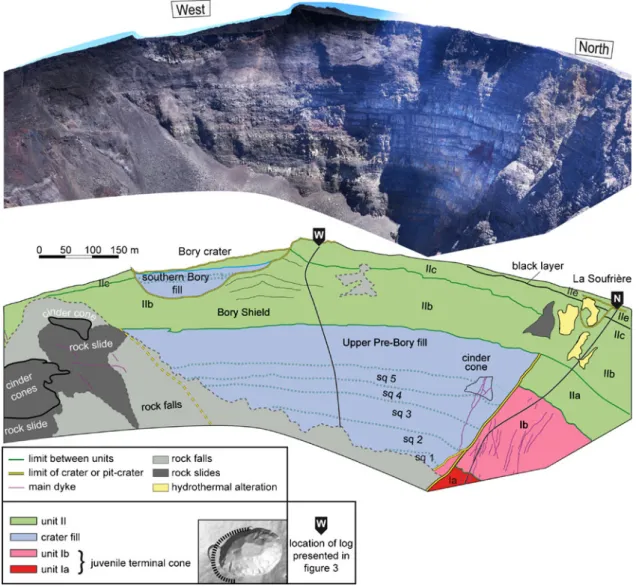
frequently changed (Fig.2). These reports describe a succes-sion of pit–crater/crater collapses and their refilling with lava flows. The most striking structure revealed by the April 2007 collapse is an ancient crater, completely filled by lava flows, visible in the western wall of Dolomieu, below the Bory crater (Figs.3,4, and5). This crater, named Pre-Bory by Lénat and Bachèlery (1990), the∼700 m diameter of which has been
constrained by morphological analysis of the summit, was a major structure of the terminal cone (Fig.2).
The detailed lithology has been investigated through anal-ysis of outcrop pictures (Figs.4,5, and6) represented in six lithostratigraphic logs in Fig. 3. Each log is extracted from analysis of a mosaic of pictures (30 cm average resolution). The geological layers are gathered into pyroclastic layers (in
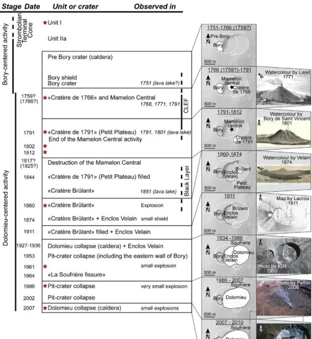
Fig. 2 On the left, summary of the historical activity of Piton de La Fournaise. Red stars represent explosive phases. On the right, sche-matic evolution of the summit of Piton de La Fournaise. The distinct periods represent the main changes. The white dotted lines and the white areas define the filled and active craters, respectively, for each period. Where the contours of the crater are not well constrained, we
use black dotted contours. The background shaded DEM corresponds to the 1990s period. The name of the craters often changed with time and observers, and for consistency, we chose to use a single name for each crater for the whole period. The reproduced watercolors and drawings are from the following publications: Bory de Saint-Vincent (1804); Velain (1878); Lacroix (1936,1938)
red in Fig.3), thin lava flows (in green in Fig.3), and pit–
crater and crater lava flow fills (in blue in Fig.3), with 1,090 geological layers observed including 855 lava flows.
There are four main lithological units: unit I, unit II, Pre-Bory, and Petit Plateau fills. Within unit II, we distinguished several sub-units by relative age, notably with respect to the Pre-Bory crater. The entire unit I and unit IIa are discordant to the Pre-Bory crater and predate it, whereas units IIb to IIe and
Petit-Plateau fills postdate the Pre-Bory crater. Each unit is described in detail below, in chronological order. Pictures of each unit, at meter and decameter scales, are presented in Fig.3.
Unit I, pyroclastic deposit-rich unit Unit I, characterized by a succession of scoriaceous layers and lava flows, is the lower unit visible in the outcrops. The pyroclastic layers appear as granular, with layered colors from dark red to
Fig. 3 Stratigraphic logs for the scarps of the Dolomieu crater. The parts of the logs where rocks are hidden by superficial rock-fall deposits are indicated by grey layers
bright yellow, and no bulky core layer. We distinguished two sub-units, units Ia and Ib, based on the proportion of pyroclastic layers and the type of intercalated lava flows.
Unit Ia (Fig.3, logs N, SW, and SE), mainly visible in the northern and southern walls of the Dolomieu crater, is a scoria-rich unit composed of a succession of pyroclastic layers and thin lava flows, most probably of‘a‘ā type (see picture 2 in Fig.3). The dominant reddish color of unit Ia reflects the preponderance of oxidized pyroclastic deposits. In the southern wall, some ochre layers, possibly composed of lapilli, form the upper part of scoriaceous-reddish layers. They may result from weathering or phreatomagmatic erup-tions. The average thickness of each pyroclastic layer in unit Ia is higher in the eastern cliff than in the south-western and northern cliffs (see logs SE, SW, and N in Fig. 3). Upward, the proportion of pyroclastic layers pro-gressively decreases, and layers grade into unit Ib at ∼2,300 m elevation (log N) and at ∼2,425 m elevation (logs SW and SE).
Unit Ib is a series dominated by thick and thin lava flows, mainly of pāhoehoe type, with a few reddish and brown scoriaceous layers (see pictures 1 and 2 in Fig.3) in which
angular blocks can be recognized and which are inferred to be of phreatomagmatic origin. Unit Ib is∼30 m thick in the south-western Dolomieu wall where the transition with unit IIa is marked (Fig. 6). Numerous dikes cut through the layers of unit I.
Unit II and crater/pit–crater fills, lava-flow-rich units At ∼2,395 m elevation in the north (log N in Fig. 3), the disappearance of pyroclastic layers marks the beginning of unit II, which is mainly composed of lavas. Distinct sub-units represent the chronology of successive main events.
The first sub-unit, sub-unit IIa, consists of a pile of lava flows becoming thinner upward and cut by the Pre-Bory crater (Figs.3,4, and5).
The Pre-Bory crater is delimited in its upper part by sub-vertical edges visible in the northern wall of the Dolomieu crater (Figs. 4 and 5). The elevation of this old crater was 2,465 m in its north-western part, and its depth was greater than 240 m (log W in Fig. 3). The Pre-Bory crater fill is composed of alternating suites of thick and thin horizontal lava flows that completely fill this crater (log W in Fig.3). At least five sequences are clearly identifiable in the low part of
Fig. 4 Panoramas and interpretations of the northern and eastern scarps of Dolomieu crater. Photographs taken in September 2009. Unit names from the text and Fig.3
the filling, each formed by a thick lava flow, light-colored, and topped by a series of thin dark pāhoehoe lava flows. The light color of thick layers known elsewhere is characteristic of slow cooling which favors a high level of crystallization in the groundmass, especially plagioclase. The top of the fill is marked by thick lava flows and some reddish levels that could be interpreted as pyroclastic fall deposits. Black, thin pāhoehoe flows are progressively less abundant.
The Pre-Bory fill (and the discordant sub-unit IIa) is directly capped by what we named the Bory Shield sub-unit (sub-sub-unit IIb, Fig.3). Sub-unit IIb displays a maximum thickness of∼80 m in log W (northwest) where it reaches its highest point,∼2,545 m. The Bory Shield is composed of a series of very thin (a few meter thick) pāhoehoe lava flows with divergent dips (Fig.5) from both sides of the Bory crater (log W in Fig.3). Lava flows associated with the Bory Shield extend to the east (Fig.4). The top of this sequence can be observed in the Bory crater, forming two thirds of the base of
the wall and topped by lava flows from the“Enclos Fouqué Lava Field” (see below). The Bory crater thus appears to be the culmination of the Bory Shield and formed after the formation of sub-unit IIb. Two light-grey thick horizontal lava flows are associated with the most recent filling of the Bory crater (Figs.5and6). No evidence of collapse faults bordering the Bory crater fill is visible in the Dolomieu wall. The Bory crater formed by coalescence of two old craters as illustrated by an aerial view of the summit in 1950 (Institut Géographique National, Fig.2), which shows two concentric structures with distinct outside slopes. Only the southern crater has been filled by thick horizontal lava flows (Figs.5and6).
The first historical reports date back to the mid-eighteenth century (Heguerty 1754; De Crémont 1770). In 1751, the activity of only one crater is described on the summit of Piton de La Fournaise. At that time, this crater, probably the Bory Shield or the Bory crater (named in 1801; Fig2) was erupting with an active lava lake or lava pound inside
Fig. 5 Panoramas and interpretations of the western scarp of the Dolomieu crater. Photograph taken in September 2009. The thin black lines underline the slopes of the unit IIb layers in the north-western scarp. Unit names from the text and Fig.3
(according to the vague written report made by Dolnet de Palmaroux in Heguerty1754). From these observations, we can deduce that most of unit IIb (Bory Shield sub-unit) was emplaced before these first observations (Fig.3).
The drawings in Bory de Saint Vincent (1804) and the watercolor of Lislet-Geoffroy in 1771 (Fig. 2) show two craters at the summit of the volcano in 1771, but it is uncertain exactly when the crater east of Bory was formed. In 1766 (or in 1753 or 1759 depending on the reports), this crater is described as active with ash (most noticeably Pele’s hairs) falling as far as 30 km west of the volcano (De Crémont1770; Dugain in Bory de Saint Vincent1804; Lacroix1936). This new crater, named“cratère de 1766” in Bory de Saint Vincent (1804) and Lacroix (1936), seems located about 300–400 m
east of the Bory crater (Fig. 2). Its activity was directly observed in 1768 (De Crémont1770). Lava emitted between 1768 and 1791 progressively formed the Mamelon Central, clearly described for the first time in 1791 by Bert (Bory de Saint Vincent1804; Lacroix1936; Fig.2) on the top of the filled“cratère de 1766”. The Mamelon Central was in 1801 a ∼50-m-high inactive cone built by scoria and overflows. The last eruption unambiguously assigned to the Mamelon Central was in June 1791 (Bert in Bory de Saint-Vincent1804; Hubert in Trouette1881; Bert in Lacroix1936). It is likely that the
opening of a new crater on 17 July 1791, only a few hundred meters away (see below), ended the activity of the Mamelon Central. Due to its location centered on the present Dolomieu crater, no sign of this structure is visible in the new outcrops. Between 1751 and 1794, most of the eruptions (and nota-bly the major eruptions occurring in 1753, 1766, and between 1775 and 1789 as described in Bory de Saint Vincent (1804) and Lacroix (1936)) fed the large field of pāhoehoe lava flows
(named “Champ de Lave de l’Enclos Fouqué (CLEF), the “Enclos Fouqué Lava Field”, by Lénat et al.2001) that still covers a large part of the western and northern slopes of the terminal cone and occupies much of the floor of the Enclos Fouqué caldera. The terminal sequences of unit II around the northern and north-eastern part of the Bory crater are those related to the“Enclos Fouqué Lava Field” (sub-unit IIc). Sub-unit IIc, 10 to 25 m in thickness, is clearly visible in Fig.5in the north-western and northern cliffs of the Dolomieu crater.
To the north of the present Dolomieu crater walls, a distinctive meter-thick black pyroclastic layer (black layer sub-unit in Figs.4and5) covers the CLEF. This black layer is visible across almost all of the northern wall and extends to 250 m west of La Soufrière (Fig. 5), where it can be observed on the surface (2,560 m elevation), partly covered by blocks ejected during one or several explosive eruptions
Fig. 6 Panoramas and interpretations of the southern scarp of the Dolomieu crater. Photographs taken in September 2009. Unit names from the text and Fig.3
(1802, 1812, or 1860; Bachèlery1981). The black layer was probably emplaced during the end of eighteenth century or the first half of the nineteenth century and is a good marker that underlies the most recent sequences in the northern wall. The black layer is exposed from the surface in the northwest to∼40 m depth in the north (Figs.4and5) where it has been covered by more recent lava flows (sub-units IId and IIe). Before 1987, this black layer was also visible in the northern third of the sequence of lava flows filling the Enclos Velain (Fig 2; Lacroix 1936; Bachèlery 1981). It was only topped by 8 to 10 m of thin young lava flows, indicating a relatively recent age for the black layer, younger than the Mamelon Central.
In the eastern wall, a sub-unit composed of very thin scoriaceous lava flow slabs (sub-unit IId; pictures 5 and 6 in Fig. 3, and Fig. 4) covers this black pyroclastic layer. Sub-unit IId is of uniform thickness over much of the eastern flank and extends from La Soufriere in the north almost to the filled Petit Plateau pit-crater in the south. Sub-unit IId may correspond to the“laves en échaudé” (shelly pāhoehoe) observed by Lacroix in 1911 (Lacroix1936) in the filled Dolomieu crater (Fig. 2) and to the then-young lava flows described by Vélain (1878) in 1874 on the flank of a broad shield built on the summit.
The only deposits associated to the eruptive activity extending beyond emplacement of the “Enclos Fouqué Lava Field” (about 1794, Lénat and Bachèlery 1990; sub-unit IIc) and sub-sub-unit IId (before 1911) are those related to the filling of the Petit Plateau pit–crater to the south. The Petit Plateau pit–crater (150–200 m in diameter; >205 m in depth; Figs.3and 6) cuts unit I and units IIa-c. It formed during a phreatomagmatic eruption, on June 17th1791, and was called “cratère de 1791” (Bert in Lacroix 1936; Bachèlery 1981; Lénat and Bachèlery 1990; Carter et al.
2007; Fig. 2). From 1791 to at least 1801, three craters existed at the summit: the Bory crater to the west where no eruptive activity had been reported after 1795 (Hubert in Lacroix1936,1938), the filled“cratère de 1766” topped by the Mamelon Central, and the new crater (“cratère de 1791”; Lacroix 1938; Figs. 2). After 1791, activity stopped at Mamelon Central, with the“cratère de 1791,” where Bory de Saint-Vincent (1804) observed an active lava lake in 1801 (390 m in diameter), becoming the most active crater for a few years. Aerial views show that the Petit Plateau pit crater (“cratère de 1791”) is bordered by numerous concen-tric fractures (Fig. 6). It is mainly filled by thick and thin lava flows with some pyroclastic layers. Samples collected during the 1980s (when the floor of the Dolomieu crater was less than 50 meters from the edge) reveal that the thick lava flows are highly crystallized, with intergranular textures and segregation veins formed during slow cooling and degass-ing. The Petit Plateau fill reaches its highest elevation at 2,530 m, close to the present surface. The Petit Plateau pit
crater (“cratère de 1791”) was the most active crater during the early nineteenth century; it was probably completely filled after the eruption of 1844 (Lacroix1936; Fig.3).
In the meantime, the Mamelon Central cone disappeared between 1817 and 1825 during successive collapses (Lacroix
1938). These collapses, described by Maillard (1853) and Vélain (1878), gradually formed in the west what Lacroix (1938) observed in 1911 as a sub-circular depression and called Enclos Velain (Fig. 2). Large explosive and effusive activities in 1802, 1812, 1821, and 1844 at the summit have been mentioned (Lacroix1936) and could be related to Enclos Velain's formation.
Also in the first half of 1800s, a new crater formed about 1,000 m east of the Bory crater. In 1851, Maillard (1853) observed an active lava lake inside it, and in 1859, lava over-flowed from this crater (Lacroix1936), indicating an eruptive activity mainly focused in the lava lake. In March 1860, a phreatic explosion enlarged the new crater. The ejected angular blocks, with decimeter size, are still visible on the surface around the Dolomieu crater, probably mixed with those from the 1766 and 1791 explosions. This new crater, first called “cratère Brûlant,” was the precursor of the modern Dolomieu crater (Fig.2). Its size often changed with successive fillings, collapses, and violent explosions (diameter and depth: 400 and 150 m in 1874, 150 and 200 m in 1889, 200 and 25 m in 1890; Bachèlery1981), but due to their location inside the present Dolomieu crater (Fig. 2), signs of these successive collapses and fillings are not now observed.
The Petit Plateau fill (“cratère de 1791”) is covered by 10– 15 m of thin and scoriaceous lava flows (sub-unit IIe; Figs.3
and6). Sub-unit IIe is also observed all along the eastern edge of the Dolomieu crater (pictures 7 and 8 in Fig.3). Unit IIe is composed of a pile of‘a’ā flows and scoriaceous layers with angular breccias at its base (sub-unit IIe1 in Fig. 4) and pāhoehoe flows (sub-unit IIe2 in Fig.4) at its top. The major-ity of these lava flows were emitted between 1911 and 1930. The late lava flows covering the scoriaceous slabs and bor-dering the scoria cone at the top of the eastern wall correspond to the pāhoehoe lava overflows of 2006 (Figs.2and3).
No observations were made between 1911 and 1927. In 1927, a depressed area of 100 m in diameter was observed at the location of the former “cratère Brûlant.” In 1930, its diameter was 400 to 500 m, and its depth was about 50 m. The intensity of collapses increased after the 1931 large-volume eruption (more than 130 × 106 m3). In 1936, Dolomieu looked like a single elongate crater with a west– east length of 600 m, a width of 400 m, and a depth of 100 m to about 150 m in its eastern part (Fig. 2). This elongate shape of the Dolomieu crater is the result of the coalescence of several collapse craters and pit craters (Lénat and Bachèlery1990; Carter et al.2007).
Successive collapse and filling episodes followed the lava overflows of 1911–1930 (Fig.2) and led to the progressive
coalescence of the floor of the Enclos Velain and Dolomieu (“cratère Brûlant”) craters after the eruption of December 1985–January 1986 (Lénat et al.1989; Fig.2). The location of all this activity remained inside the present limits of the Dolomieu crater; thus no visible evidence remains. Only the La Soufrière depression (80 m in diameter) is still visible in the northern wall of Dolomieu (Figs.4and5). La Soufrière formed during the 1965 eruption; the emptying of the upper part of the fissure system left a cavity that reached the surface (La Soufrière). Exploration of La Soufrière in the 1980s revealed the presence of a conduit at its base, widespread rock alteration, and sulfur smells (internal OVPF report). La Soufrière's size gradually increased over years from 6 m in 1980 to nearly 80 m in 2000. No fracture is visible at the base of La Soufrière in the Dolomieu outcrops (Figs. 4 and 5). Aerial views of La Soufrière show that it is bordered by numerous concentric fractures (see enlargement in Fig.4b).
The last crater collapse occurred in 5–6 April 2007. Unlike the collapses of 1927–1936, it was quite fast (less than 36 h) and was associated with an exceptionally voluminous erup-tion (∼220×106
m3of emitted lava flows,∼100 times larger than the volume emitted during a typical eruption at Piton de La Fournaise; Bachèlery et al.2010) from a distant eruptive fissure (6 km from the summit; Michon et al.2007a; Peltier et al.2009a; Staudacher et al.2009). As with the 1927–1936 collapses (Lacroix1938), no large explosive eruption accom-panied the collapse. Just after the 2007 collapse, Dolomieu was 1,030×750 m in diameter (almost the same as before the collapse, except a slight expansion of a few tens of meters to the north, west, and south) and 340 m deep (Urai et al.2007; Staudacher et al.2009; Fig.2).
Magma feeding structures
Several structures of the uppermost part of the internal feeding system (dike swarms, sills, and small solidified magma storage zones) and intersecting lava flows can be observed in the new outcrops.
Most of the dikes are grouped in swarms. The main swarms are located to the southwest, the north (below La Soufrière), and to the southeast (Figs.4,5, and6). The thicknesses of the dike, deduced from image processing, range from 0.03 to 2 m. Because we have only access to a 2D section, it is difficult to recognize if these dikes were aborted intrusions or if they fed lava flows at paleo-surfaces buried behind the scarp, but a few examples of eruption feeding dikes are visible in outcrop, espe-cially at the base of cinder cones (see enlargement in Fig.4a). Cinder cones of red scoria appear in cross-section in the western (∼30 m height and ∼50 m width, in the Pre-Bory fill), eastern (∼50 m width), south-western (∼100 m width), and north-eastern outcrops (partially covered by rock slides) (Figs.4,5, and6).
Other dikes are associated with the feeding of small shallow now-solidified magma storage zones. In the eastern wall, at
about 10–15 m below the surface, two grey sub-circular bodies surrounded by a reddish halo are interpreted as solidified mag-ma accumulated at shallow depth (up to 30 m height; see enlargement in Fig.4c).
Only one good example of a sill has been unambig-uously recognized in the lava flow pile of the eastern wall. This sill follows the horizontal stratigraphy for a distance of about 100 m before being vertically re-orientated/deflected on each side. Because of the obser-vation distance, it is difficult to recognize whether other sills are present among the lava flow layers.
Hydrothermal features
After the April 2007 collapse, fumaroles were observed along a belt at about 2,350 m elevation inside the Dolomieu crater. Temperature along this belt remained high 1 year after the collapse (50 to 100 °C; Staudacher 2010). The fumarole belt highlights the fault system active during the April 2007 Dolomieu collapse. Resumption of eruptive activity in 2008 inside the Dolomieu crater (to the west in September and November 2008 and to the east and to the north in December 2008) was focused along the same fault system as the fumaroles. In addition to the fumarolic evi-dence of present hydrothermal activity, two types of hydro-thermal alteration can be observed (Fig.7): (1) large altered areas at the boundaries of the summit pit–crater and cavity and (2) altered areas along individual intrusions.
Large zones of yellow hydrothermal alteration coat the outcrops of the Pre-Bory crater and Petit plateau pit–crater (Fig.7d, e) and are also visible at the boundaries between the pit–crater fills (thick lava flows) and the surrounding piles of thinner lava flows and pyroclastites. Widespread rock alter-ation on the walls of La Soufrière described during its explo-ration in the 1980s (internal OVPF report) is also still visible, with hydrothermal yellow deposits bordering both the cavity itself and associated concentric fractures (Fig.7a, b, c).
Hydrothermal alteration around intrusions is also visible; the most obvious are in the eastern part of Dolomieu. These latter are associated with two shallow magma storage zones (∼10–15 m below the surface; Fig. 7f, g). Such alteration could result from degassing of the last magma inside these small magma storage zones, inducing hydrothermal aureoles a few tens of meters wide. We note that dikes around the caldera walls do not display any similar alteration, probably due to the smaller magma volumes involved.
Discussion
In this section, we first discuss specifically the construction and plumbing system of Piton de La Fournaise and then expand the discussion to include other basaltic shields.
Chronology of exogenous construction of the Piton de La Fournaise terminal cone
Unit I: the juvenile strombolian terminal cone
Unit I forms the basement of the juvenile terminal cone and accumulated on the floor of the “Enclos Fouqué” caldera, formed 4,500 years ago (Bachèlery1981; Staudacher and Allègre 1993). The oldest layers visible in the Dolomieu outcrops lie at∼2,270 m elevation, almost the same eleva-tion as the present floor of the “Enclos Fouqué” caldera (Fig.1). Among the new outcrops, the oldest deposits are a succession (unit I in Fig.3) of lava flows and red pyro-clastic layers produced by explosive activity. The
interstratification of red scoria layers with lava flow layers could indicate alternation between large explosive sporadic eruptions and effusive ones. In the other hand, Michon et al. (2009b) interpret this large outcrop of reddish cinder cones and pyroclastic layers as the top of a “hidden strombolian pyroclastic cone.” This pyroclastic cone would constitute most of the terminal cone in its early stage of construction and could explain the abnormally high slopes of the terminal cone (15–25° and up to 35° in some places; Michon et al.
2009b), compared with other basaltic volcanoes.
In any case, the summit of unit I was most probably centered below the south-western cliff, though it is not possible to determine the distribution of these pyroclastic deposits outside of the summit zone. The transition from
Fig. 7 Pictures taken in May 2007 showing hydrothermal alteration (outlined in white): a, b, c close to La Soufrière; d on the southern flank, and f, g on the eastern flank of the Dolomieu crater. e Aerial view of the Dolomieu crater
unit I to unit II, with more frequent pāhoehoe lava flows and the disappearance of thick scoriaceous fall layers, is inferred to mark a change in magma supply and/or composition over time. The presence of ochre pyroclastic layers with angular blocks in unit Ib also reflects a change from purely mag-matic (Ia) to phreatomagmag-matic (Ib) eruptions.
Bory-centered activity (until∼1759–1766)
Unit II marks a change from explosive to effusive activity, with lava flow emissions of a more degassed magma. This change probably caused the Pre-Bory crater collapse and the following ones. As observed in 2007, a high magma output rate during many years and the rapid emptying of the shallow plumbing system during effusion of voluminous lavas from the base of the cone can lead to summit collapse (Michon et al.
2007a,2009a; Peltier et al.2009a; Staudacher et al.2009). The activity before 1751–1766 was clearly focused on the western side of the present summit zone, notably includ-ing formation of the Pre-Bory crater, its fillinclud-ing, and con-struction of the Bory Shield capped by the Bory crater.
The size of the Pre-Bory crater is deduced from the Dolomieu outcrops and the general morphology of the sum-mit (Fig.2; Lénat and Bachèlery1990). Its northern bound-ary is vertical in the upper part of the crater and then has an inward dip of about 50° (Figs.4 and 5). This is strongly similar to the shape of the Dolomieu crater. No pyroclastic deposit is observable among the formations identified on the edge of the Pre-Bory crater. The formation of the Pre-Bory crater would be thus similar to that of the Dolomieu caldera in 2007, involving rapid incremental collapse without major explosive activity (Michon et al.2007a,2009a; Peltier et al.
2009a; Staudacher et al.2009).
Two modes of crater fills can be observed: (1) the main one, characterized by thick white lava layers (up to 30 m thick) representing lava lakes or lava ponds associated with continuous or quasi continuous effusive activity on daily to monthly time scales; (2) the secondary one, characterized by thin dark lavas emitted on the frozen lava lake over short periods from summit vents (Figs.3,4, and5). The filled Pre-Bory crater holds at least 90×106 m3 of lava, a volume similar to that which filled the Dolomieu crater between 1936 and 2007 (∼80×106
m3). If we infer similar activity and feeding rates for these two structures, then the Pre-Bory crater filled rapidly, probably in a few decades and certainly in less than a century.
No evidence of collapse structures (fractures) corresponding to the limits of the Bory crater is visible in the western outcrop (Fig.5). Either the Bory crater formed by collapse along a ring fault tangential to the cliff and thus not visible, or as a result of numerous short explosive eruptions that progressively built the Bory Shield. The convex slopes of the Bory Shield layers (sub-unit IIb) in the north-western cliff of Dolomieu (Fig. 5)
strengthen the hypothesis that the Bory crater was at the summit of an old "shield," overlying the Pre-Bory lava unit and formed during a long-lived effusive magmatic activity. This Bory Shield extended up to the east of the present Dolomieu crater (sub-unit IIb in Figs.4and5). The compar-ison of logs N and SE with logs W and S suggests that the sub-unit IIb is thicker in the north-western part of the present Dolomieu (Fig.3). This is consistent with the presence of a shield centered on the Bory crater.
The activity in the Bory crater described by Dolnet de Palmaroux (in Heguerty 1754 and Bory de Saint Vincent
1804) and by Hubert (in Lacroix1938) prior to 1759–1766
was most probably related to a lava lake. Indeed, marks of slow cooling, typical of lava lakes, are visible in the upper part of the western Dolomieu crater outcrop, where a thick (10–20 m) white lava layer (Figs.5and6) lies just below the floor of the Bory crater (at 5 m below the surface). Part of the lava overflows associated with this summit activity could have fed the “Enclos Fouqué Lava Field” (CLEF), which is the result of effusive events probably spread over several years to decades (1751 to 1794, Lénat et al.2001). The distribution of the CLEF lava flows on the Enclos Fouqué floor (to the west and the north) and the lack of CLEF lava flows in the eastern and southern walls of Dolomieu confirm that the main emission center was the Bory crater (or the Bory Shield), as suggested by Lénat et al.
2001. The Bory crater and the outpouring of lava forming the “Enclos Fouqué Lava Field” were the result of a long and mostly effusive magmatic activity, originating for sev-eral decades from a single eruptive structure built on the top of the Pre-Bory crater fill.
Dolomieu-centered activity (since∼1759–1766)
Since 1795, no major eruptive activity has been reported in the Bory crater. From the middle of the eighteenth century, the eruptive activity migrated to the east of the summit with successive active craters and collapses (i.e., the successive formation of the “cratère de 1766” and the “Mamelon Central” between 1759 and 1791, then the “cratère Brûlant” from the second half of the nineteenth century; Fig. 2). It also marks the shifting of the activity from the Bory crater to the present Dolomieu crater. This migration of the central activity was responsible for a change in the morphology of the summit zone already noticed by Bory de Saint-Vincent (1804; Fig. 2). The effusive activity reported in 1801 in the “cratère de 1791” (Petit Plateau) produced thick and highly crystallized lava flows (Fig.6), typical of slow cooling and thus to a period of lava lake/ pond activity. By contrast, the late thin lava flows that filled Petit Plateau corresponded to low-volume eruptions (Figs.3
and6). We can estimate a lower limit for the filling rate of Petit Plateau at 0.1×10⁶m3year−1between 1791 and 1844.
At the end of the nineteenth and during the twentieth cen-tury, the Dolomieu crater (Enclos Velain and “cratère Brûlant”) progressively enlarged by successive collapses and was then filled by pāhoehoe lava flows (sub-units IId and IIe; Figs.3,4,5, and6).
As a whole, the building of the terminal cone was not continuous in time, and its present shape results from the succession of constructive (explosive/effusive emissions) and destructive phases (crater/pit–crater collapses). Some of these summit collapses were accompanied by explosive eruptions of moderate intensity, leaving little mark on the lithology. Thick pyroclastic layers such as the“Cendres de Bellecombe” deposits found outside of the Enclos Fouqué caldera (Bachèlery1981; Abchir et al.1998) are the result of a different process and represent exceptional events in the history of this volcano. Such exceptional explosive erup-tions are very important when considering volcanic hazards of basaltic shield volcanoes. We infer that, from the early stage of the terminal cone's formation to now, there has been a transition from explosive magmatic activity to mainly effusive activity (such as the long-lived effusive activity associated to the Bory Shield (sub-unit IIb).
Contribution of endogenous growth to construction of the Piton de La Fournaise terminal cone
Though remnants of the feeding system are preserved in the Dolomieu outcrops (dike swarms, small shallow magma storage zones), endogenous activity contributed little to growth of the upper part of the terminal cone. To quantify the current exogenous growth, we can roughly estimate from GPS measurements (OVPF data) the internal volume change of the terminal cone. Though this volume is approx-imate and deduced from only ten GPS stations (five at the summit at five at the base of the terminal cone), it indicates for the 2005–2007 period an endogenous volume of 2.3× 10⁶m3, versus 26×106m3, an order of magnitude higher, for lava flows at the summit or along the flanks of the terminal cone (Peltier et al.2009b). This is in contrast with the numerical simulation of Annen et al. (2001), which modeled the terminal cone with a predominantly endoge-nous growth of 10,000 short and thick dike intrusions, feeding only 700 low-volume lava flows, suggesting a ratio between the number of eruptions and the total number of dike injections of 0.07. Since the implementation of the volcanological observatory in 1980, we have observed that the ratio between the number of eruptions and the total number of dike injections is ∼0.8 with only 12 aborted intrusions versus 61 eruptions between 1980 and 2010 (Peltier et al., 2009b; Roult et al. 2012). Our estimation, and the small number and size of dikes observed in the basement of the terminal cone, suggest that growth of the Piton de la Fournaise terminal cone is largely exogenous.
During the three last centuries, summit or near-summit eruptions (40 % of the eruptions during the twentieth cen-tury; Bachèlery 1981; Peltier et al. 2009b) were the main contributors to cone growth.
Magma feeding system of Piton de La Fournaise
Our study reveals the persistence, for several centuries, of the summit craters of Piton de la Fournaise and the overall stability of their position over time. This reflects continuity in the location of the shallow magma feeding system of the volcano. However, a limited migration of the activity toward the east seems to have occurred, from Bory-centered activity to Dolomieu-centered activity (see above). Currently, the Dolomieu crater is the only active crater at the summit of Piton de La Fournaise. The migration of activity centers may be related to modification of the underlying magma transfer system, and specifically, the destruction/modifica-tion of the magma reservoir during summit collapses may lead to the formation of a new activity center (see “compar-ison with other volcanoes” below).
The location of the cinder cones, the dike swarms, and the shallow magma storage zones, mainly to the southwest, to the north, and to the east, corresponds to the preferred pathways of magma to the surface and to major structural limits (delimiting the present Dolomieu crater), which were active during the most recent collapses (1927–1936, 2007; Fig. 2). The limit between the Bory and the Dolomieu craters is a well-known structural path taken by numerous recent dikes starting from the west part of Dolomieu to feed summit and flank eruptions (Peltier et al. 2009b). In the same way, the northern limit bordering the Pre-Bory crater as well the south-western part of the summit, corresponding to the beginnings of the northern and southern rift zones, respectively, have a high density of dikes and cinder cones. Some dikes overlap with unit I only (Figs. 4, 5, and 6) showing that the southern part of the summit has been a preferred path for magma since the juvenile stage of the terminal cone. Considering our observations, we propose that either (a) the south-western part of the magma reservoir roof concentrates stresses to favor dike emplacement here, or (b) the magma reservoir is shifted below the western part of the summit, as inferred from seismic studies. Nercessian et al. (1996) and Massin et al. (2011) found, with tomogra-phy and double-difference relocations, that the earthquakes located around sea level are focused at the boundary be-tween the Bory and Dolomieu craters and inferred that they could indicate the position of the magma chamber. Battaglia et al. (2005) and Prôno et al (2009) consider, from amplitude location and double-difference tomography, that a magma reservoir should be located 3.5 to 4 km below Dolomieu and that a network of dikes dipping toward the Bory should lie 1 to 2 km below the summit. Their models are consistent with
the hypothesis that the Pre-Bory collapse structure may guide magma ascent.
In 2008–2009, eruptive activity was concentrated along a pre-existing structure circling the entire inner walls of the Dolomieu crater, where a fumarole belt emanates after the April 2007 Dolomieu collapse (Staudacher2010). This fu-marole belt highlights a preferred zone for propagation of fluids toward the surface. The superposition of dikes, erup-tive sites, and pre-existent fractures suggests a structural control on dike propagation and on collapses since at least the first historical observations.
The size of summit crater and pit–crater collapses can give us an estimation of the size of the drained cavity at depth (Roche et al. 2000, 2001). The smallest pit–craters
such as Petit-Plateau and also the most recent ones formed in 1986 and 2002 (150 m in diameter/80 m deep and 200 m in diameter/25 m deep, respectively, but no longer visible; Delorme et al.1989; Longpré et al. 2007), most probably formed in response to emptying of small shallow magma storage zones, like the ones observed in the Dolomieu crater outcrops (Fig. 4c). Rising magma can be trapped along lithological discontinuities to form residual magma storage zones, which can empty in the late stage of eruptions to form shallow cavities and initiate pit–craters (Hirn et al. 1991; Longpré et al. 2007). Through a point source model, Delorme et al. (1989) estimated a deflation source located at 0.1–0.4 km depth just before the 1986 pit–crater collapse. By contrast, the Pre-Bory and Dolomieu collapses were linked to the withdrawal of larger and deeper magma bodies. The most recent Dolomieu crater collapses (1931 and April 2007) were associated with fast drainage of large volumes of magma at depth, with effused lavas exceeding 100×106m3 (∼130×106
m3in 1931,∼220×106m3in 2007; Bachèlery et al. 2010). These deeper sources correspond to the main storage zone at depth, and these collapse craters can thus be considered as true calderas (Michon et al.2007a). The volume of the April 2007 collapse (∼90×106
m3) corre-sponds at ∼1/3 of the estimated volume of the magma reservoir located at ∼2.5 km depth (∼300–350×106 m3; Sigmarsson et al.2005; Peltier et al.2007). See Michon et al. (2007a,2009a), Peltier et al. (2009a), and Staudacher et al. (2009) and Massin et al. (2011) for more information on the April 2007 collapse.
Hydrothermal system of the Piton de La Fournaise volcano
The presence of many large yellow alteration zones, as well as fumaroles, along localized fault planes in the new Dolomieu outcrops confirms the presence of water flows below the summit. The preferred location of hydrothermal fluid flows at the outer limits of the craters and pit–craters could be explained both (1) by the permeability contrast between the thick massive lava flows filling the crater
versus the more permeable surrounding lavas (Pre-Bory, Petit-Plateau; Fig.7) and (2) by the fractures bordering the lithological contrast at the boundary of the pit–craters and craters (Pre-Bory, Petit-Plateau, La Soufrière; Fig.7).
In the same way, the yellow alteration coating the Pre-Bory and Petit-Plateau outcrops is linked to preferential hydrothermal fluid circulation along the faults bounding the Dolomieu crater, which are a main structure also con-trolling magma ascent and caldera collapse.
In addition, a comparison between the location of hydro-thermal alteration along the caldera outcrops (Fig.7) and the present-day positive self-potential anomalies (Michel and Zlotnicki 1998; Malengreau et al. 1999; Barde-Cabusson et al.2012) reveals a good correlation interpreted as the signature of upward fluid flows to the north, south, and east of Dolomieu. These three main locations are along the rift zone axis and have higher permeabilities than the surroundings (Fig.1). On the uppermost part of the terminal cone, only signs of superficial fluid circulations along vertical discontinuities are visible. The hydrothermal system suggested by Lénat et al. (2012), from a combination of geological and geophysical data, is confined deeper in the faulted and crumbled rock cylinder below the summit, as attested to by geo-electrical studies. From 300 m depth to the limited depth of investigation (∼1,000 m), Lénat et al. (2000) observed an electrical conduc-tor below the summit interpreted as the altered hydrothermal zone (resistivity values<20Ωm below ∼500 m depth and <250 Ωm from ∼500 m up to ∼300 m depth), whereas the overbur-den (now exposed in the outcrops) is composed of resistive layers, interpreted as a water-sparse region (1,000 to 3,000Ωm and>8,000Ωm for the shallowest 100 m).
Comparison with other basaltic shields
Construction of the summits of basaltic shields
Basaltic shields result both from exogenous and endogenous growth. The Piton de La Fournaise terminal cone is a good example of a predominantly exogenously grown volcano. This is in contrast with the most persistently active volca-noes (Francis et al.1993).
Even though the main activity of some basaltic shields is sporadic and effusive, long-lived eruptions sometimes occur and may dominate construction of the shield. The shape and lithology of unit I at Piton de La Fournaise looks similar to the inner part of Pu’u’O’o cone at Kilauea, Hawaii (Heliker et al.
1998); both structures expose strata of agglutinated spatter, lava flows, and unconsolidated tephra that mainly result from high fountaining during more or less brief periods (1983– 1986 for Pu’u’O’o) within long-lived eruptions (Heliker et al.2003). One of the main characteristics of complex basaltic cones is the existence of rootless lava flows generated by spatter agglutination. High-rate lava fountaining supplies the
flows of pyroclastic materials that fall on the flanks of the cone. The eruption style depends on the magma supply rate and gas content, and the flowing style (‘a‘ā and pāhoehoe) also depends on the flank slope. For a given flank slope, pāhoehoe lavas are generally associated with low output rates of degassed magma, whereas ‘a‘ā flows are linked to high output rates (Walker 1973). During episodes of very high fountaining, fountain-fed‘a‘ā flows become frequent and are significantly involved in the construction of the cone, as observed in unit I. The red layers are pyroclastic fall deposits oxidized at high temperature. These observations are consis-tent with the existence of similar long-lived structures at Pu’u’O’o and at the top of Piton de la Fournaise in the past and dominating the exogenous growth of the edifice.
Though endogenous growth is not predominant at Piton de La Fournaise, signs of endogenous construction give information on the stress field inside the edifice. Dikes propagate parallel to the maximum compression axes σ1 within cone;σ1 is vertical at depth favoring vertical magma migration, as observed in the craters walls of many basaltic shields. Toward the surface, stress can favor dike arrest. Observations on caldera walls of basaltic volcanoes show that many dikes become arrested at shallow depths (Geshi et al. 2010). Because of the lack of the third dimension in outcrop, it is difficult to recognize arrested intrusions at Piton de La Fournaise. In 2008, however, the renewal of activity at Piton de La Fournaise began with numerous non-erupting intrusions (Peltier et al. 2010), suggesting that a change in the stress field after the April 2007 collapse subsequently favored the arrest of dikes at depth.
Host-rock properties and thermal effects as well as mag-ma overpressure and volume are among the factors control-ling dike growth. Taisne and Tait (2009) suggest that a buoyant propagating dike of finite volume can be stopped at depth by a high three-dimensional fracture toughness of the host medium. At the curved dike front, horizontal crack-ing is necessary to allow the vertical propagation of the dike. As the dike elongates and thins at the front, it becomes progressively harder to fracture the host. A minimum vol-ume of magma must be thus released in the dike in order to produce an eruption.
At layer discontinuities, some dikes may change into sills (or vice versa) or, depending on the softness of the rock and the stress state, form small magma storage zones of various shapes (Gudmundsson2011) as observed in the crater walls of Piton de La Fournaise.
Impact of summit collapses on the evolution of basaltic shields
As observed at Piton de La Fournaise, but also at Tenerife (Canary Islands; Marti and Gudmundsson2000), Miyakejima (Japan; Geshi et al. 2002), and on Hawaiian volcanoes
(Decker and Christiansen1984), summit collapses commonly occurred during basaltic shield construction. Collapses influ-ence the location of subsequent activity.
Migration of eruptive activity is often observed on basal-tic shields. This migration occurred on two scales at Piton de La Fournaise: on a small spatial scale (terminal cone), with a migration of the activity toward the east of the summit in the last centuries; and on a larger spatial and probably longer time scale, with a migration of the volcanic center during the last 400 ky from Plaine des Sables (∼6 km from the present summit) to its current location (Bachèlery and Mairine
1990; Letourneur et al.2008; Merle et al.2010). In a same way, Las Cañadas caldera (∼15 km in a SW–NE direction; Tenerife, Canary Islands) results from multiple episodes of collapse (Marti and Gudmundsson 2000) with a migration of volcanism from west to east. Models show that this migration was linked to the destruction of the feeding mag-ma reservoir during each collapse. The resulting change in the local stress field favored the formation of a new magma reservoir and thus led to a migration of the plumbing sys-tem. The small migration of activity (collapse/eruptions) observed at the summit of Piton de La Fournaise in the last centuries could be linked to the same process. At a smaller scale, each successive recent summit collapse destroyed the associated shallow magma reservoir, and a new one formed on the eastern side of the previous one. The present location of shallow seismicity (from 0 to 2,000 asl), to the west of the summit, at the junction below the Bory and the Dolomieu craters (Massin et al. 2011) attests to the presence of a damaged and faulted zone in the western part of the summit.
Role of a hydrothermal system on the evolution of the summits of basaltic shields?
On the uppermost part of a basaltic shield, only preferential fluid flows channelized along higher permeability structural boundaries (such as craters or pit–craters) are visible, the hydrothermal system itself being confined at depth. Such observations have been made on active volcanoes by cou-pling complementary geophysical and geochemical fluid flow methods; in Stromboli (Finizola et al. 2002; Revil et al.2004), Vulcano (Revil et al.2008; Barde-Cabusson et al.
2009), Santa María–Cerro Quemado–Zunil volcanoes and
Xela caldera (Bennati et al.2011).
As proposed by Lénat et al. (2012), the hydrothermal sys-tem may play a role in the development of magma injections and volcanic instabilities and thus in the constructive and destructive phases of basaltic shields. During the most recent Piton de la Fournaise caldera collapses (notably in 2007), and as observed during the Miyakejima caldera collapse in 2000, no major explosive, phreatic or phreatomagmatic, activity and thus no strong magma–water interaction seemed to occur. The phreatic and phreatomagmatic eruptions during the collapse of
a conduit were triggered by magma/hot rocks–water interac-tion caused by the invasion of groundwater into the magma conduit (Decker and Christiansen1984). In the case of Piton de La Fournaise, not much magma would be stored inside the terminal cone, notably inside the cylinder block that collapsed in 2007. This can explain the contrast in behavior between the formation of the Piton de La Fournaise and Miyakejima cal-deras (Michon et al.2011) or the Hawaiian ones (Decker and Christiansen1984) and suggests that the existence of magma in the collapsed block is the most important factor for causing explosive eruptions during caldera collapse (Geshi et al.2002).
Acknowledgments Part of this work has been made in the framework of the project“Aléas: Evaluation du risque volcanique à La Réunion et prise en compte dans la gestion de crise (2011–2012)” funded by MEE-DEM. The authors thank A. Di Muro, L. Michon, and N. Villeneuve, partners of this project, for fruitful discussions. We are thankful to the two anonymous reviewers, to Paul Gettings, to the associate editor, Agust Gudmundsson, to the executive editor, James White, for the major improvements that have been pointed out. We are grateful to Christian Germanaz, Francois Martel, and Laurent Michon for providing us histor-ical documents. This is IPGP contribution number 3297.
References
Abchir AM, Semet MP, Boudon G, Ildefonse P, Bachèlery P, Clocchiatti R (1998) Huge hydrothermal explosive activity on Piton de la Fournaise, Reunion Island: The Bellecombe Ash Member, 2700 BC. In: The European Laboratory Volcanoes, Proceedings of the 2nd workshop, Santorini, Greece, Casale R. et al. (eds), European Commission, Brussels, 447–455
Annen C, Lénat JF, Provost A (2001) The long term growth of volcanic edifices: numerical modeling of the role of dyke intrusion and lava-flow emplacement. J Volcanol Geotherm Res 105:263–289 Bachèlery P (1981) Le Piton de La Fournaise: Etude Volcanologique,
Structurale et Pétrologique. PhD thesis, University of Clermont Ferrand, France: 1-257
Bachèlery P, Mairine P (1990) Evolution volcano-structurale du Piton de La Fournaise depuis 0.53 Ma. In: Lénat J-F (ed) Le volcanisme de La Réunion-Monographie: Centre de Recherche en Volcanologie. Clermont Ferrand, France, pp 213–242
Bachèlery P, Michon L (2010) The Enclos caldera: how did it form? IAVCEI Third Workshop on Collapse Calderas, La Réunion, pp 105–108
Bachèlery P, Saint-Ange F, Villeneuve N, Savoye B, Normand A, Le Drezen E, Barrère A, Quod J.-P, Deplus C (2010) Huge lava flows into the sea and caldera collapse, April 2007, Piton de la Fournaise volcano. IAVCEI Third Workshop on Collapse Calderas, La Réunion, 3-9 October 2010, 73-74
Barde-Cabusson S, Finizola A, Revil A, Ricci T, Piscitelli S, Rizzo E, Angeletti B, Balasco M, Bennati L, Byrdina S, Carzaniga N, Crespy A, Di Gangi F, Morin J, Perrone A, Rossi M, Roulleau E, Suski B, Villeneuve N (2009) New geological insights and structural control on fluid circulation in La Fossa cone (Vulcano, Aeolian Islands, Italy). J Volcanol Geotherm Res 185:231–245 Barde-Cabusson S, Finizola A, Peltier A, Chaput M, Taquet N,
Dumont S, Duputel Z, Guy A, Mathieu L, Saumet S, Sorbadère F, Vieille M (2012) Structural control of eruptive and collapse events evidenced by self-potential mapping on the Piton de la Fournaise volcano (La Réunion Island). J Volcanol Geotherm Res 209–210:9–18
Battaglia J, Ferrazzini V, Staudacher T, Aki K, Cheminée JL (2005) Pre-eruptive migration of earthquakes at the Piton de La Fournaise volcano (Réunion Island). Geophy J Intern 161:549–558
Bennati L, Finizola A, Walker J, Lopez D, Higuiera-Diaz C, Schütze C, Barahona F, Cartagena R, Conde V, Funes R, Rios C (2011) Fluid circulation in a complex volcano-tectonic setting, inferred from self-potential and soil CO2flux surveys: the Santa María–Cerro Quemado–Zunil volcanoes and Xela caldera (northwestern Guatemala). J Volcanol Geotherm Res 199:216–229
Bonaldi F, Corazzato C, Tibaldi A (2011) Identifying rift zones on volcanoes: an example from La Réunion Island, Indian Ocean. Bull Volcanol 73(3):347–366
Carter A, van Wyk de Vries B, Kelfoun K, Bachèlery P, Briole P (2007) Pits, rifts and slumps: the summit structure of Piton de la Fournaise. Bull Volcanol 69:741–756
De Crémont (1770) Relation du premier voyage fait au volcan de l’île de Bourbon. In L’année littéraire par M. Fréron, Année 1770, t VII, Lettre IV, reprint by Harvard College Library in 1922 Bory de Saint-Vincent (1804) Voyages dans les quatre principales îles des
mers d’Afrique. Réédition: Lafitte reprints, 1980, Eds. Marseille Decker RW, Christiansen RL (1984) Explosive eruption of Kilauea
Volcano, Hawaii. In: National Research Coucil (ed) Explosive volcanism: inception, evolution, and hazards (studies in geophys-ics). National Academy Press, Washington, DC, pp 122–132 Delorme H, Bachèlery P, Blum PA, Cheminée JL, Delarue JF,
Delmond JC, Hirn A, Lepine JC, Vincent PM, Zlotnicki J (1989) March 1986 eruptive episodes at Piton de La Fournaise volcano (Réunion Island). J Volcanol Geotherm Res 36:199–208 Finizola A, Sortino S, Lénat JF, Valenza M (2002) Fluid circulation at Stromboli volcano (Aeolian Islands, Italy) from self-potential and CO2surveys. J Volcanol Geotherm Res 116:1–18
Francis P, Oppenheimer C, Stevenson D (1993) Endogenous growth of persistently active volcanoes. Nature 366:554–557
Geshi N, Shimano T, Chiba T, Nakada S (2002) Caldera collapse during the 2000 eruption of Miyakejima Volcano, Japan. Bull Volcanol 64:55–68
Geshi N, Kusumoto S, Gudmundsson A (2010) Geometric differ-ence between non-feeder and feeder dikes. Geology 38 (3):195–198
Gudmundsson A (2011) Deflection of dykes into sills at discontinuities and magma-chamber formation. Tectonophysics 500:50–64 Heguerty D (1754) Relation d’un voyage à l’île Bourbon. Mémoire de
l’Acad. Royale de Nancy t 1:73–91
Heliker CC, Mangan MT, Mattox TN, Kauahikaua JP, Helz RT (1998) The character of long-term eruptions: inferences from episodes 50–53 of the Pu'u 'Ō'ō-Kūpaianaha eruption of Kīlauea Volcano. Bull Volcanol 59:381–393
Heliker C, Kauahikaua J, Sherrod DR, Lisowski M, Cervelli PF (2003) The rise and fall of Pu'u 'O'o cone, 1983-2002, in The Pu'u 'O'o-Kupaianaha eruption of Kilauea volcano, Hawai'i: The first 20 years, USGS Prof. Paper 1676, edited by C. Heliker, D.A. Swanson et T.J. Takahashi, p 28-51, U.S. Geological Survey Hirn A, Lépine JC, Sapin M, Delorme H (1991) Episodes of pit–crater
collapse documented by seismology at Piton de la Fournaise. J Volcanol Geotherm Res 47:89–104
Lacroix A (1936) Le volcan actif de l’île de La Réunion et ses produits. Gauthier Villars (ed) Paris, p 295
Lacroix A (1938) Le volcan actif de La Réunion (supplement) et celui de la Grande Comore. Gauthier Villars (ed) Paris, p 57 Lénat JF, Bachèlery P (1990) Structure et fonctionnement de la zone
centrale du Piton de la Fournaise, in Le volcanisme de la Réunion, Monographie, edited by J.-F. Lénat, 257–296
Lénat JF, Bachèlery P, Bonneville A, Hirn A (1989) The beginning of the 1985–1987 eruptive cycle at Piton de La Fournaise (La Reunion); new insights in the magmatic and volcano-tectonic systems. J Volcanol Geotherm Res 36:209–232
Lénat JF, Fitterman D, Jackson DB, Labazuy P (2000) Geoelectrical structure of the central zone of Piton de la Fournaise volcano (Réunion). Bull Volcanol 62:75–89
Lénat JF, Bachèlery P, Desmulier F (2001) Genèse du champ de lave de l’Enclos Fouqué : Une éruption d’envergure exceptionnelle du Piton de la Fournaise (Réunion) au 18e siècle. Bull Soc Géologique de France, T 172, n° 2, 177-188
Lénat JF, Bachèlery P, Peltier A (2012) The interplay between collapse structures, hydrothermal systems, and magma intrusions: the case of the central area of Piton de La Fournaise volcano. Bull Volcanol 74(2):407–421
Letourneur L, Peltier A, Staudacher T, Gudmundsson A (2008) The effects of rock heterogeneities on dyke paths and asym-metric ground deformation: the example of Piton de la Fournaise (Réunion Island). J Volcanol Geotherm Res 173:289–302
Longpré MA, Staudacher T, Stix J (2007) The November 2002 erup-tion at Piton de La Fournaise volcano, La Réunion Island: ground deformation, seismicity, and pit crater collapse. Bull Volcanol 69:511–525
Maillard ML (1853) Notes sur l’île de La Réunion. Bull Soc Geol France, 2e série, tome 10:499–505
Malengreau B, Lénat JF, Froger JL (1999) Structure of Réunion Island (Indian Ocean) inferred from the interpretation of gravity anoma-lies. J Volcanol Geotherm Res 88:131–146
Marti J, Gudmundsson A (2000) The Las Cañadas caldera (Tenerife, Canary Islands): an overlapping collapse caldera generated by magma-chamber migration. J Volcanol Geotherm Res 103:161– 173
Massin F, Ferrazzini V, Bachèlery P, Nercessian A, Duputel Z, Staudacher T (2011) Structures and evolution of the plumbing system of Piton de la Fournaise volcano inferred from clustering of 2007 eruptive cycle seismicity. J Volcanol Geotherm Res 202:96–106
Merle O, Mairine P, Michon L, Bachèlery P, Smietana M (2010) Calderas, landslides and paleo-canyons on Piton de la Fournaise volcano (La Réunion Island, Indian Ocean). J Volcanol Geotherm Res 189:131–142
Michel S, Zlotnicki J (1998) Self-potential and magnetic surveying of la Fournaise volcano (Réunion Island): correlations with faulting, fluid circulation and eruption. J Geophys Res 103(B8):17,845– 17,857
Michon L, Staudacher T, Ferrazzini V, Bachèlery P, Marti J (2007a) April 2007 collapse of Piton de La Fournaise: a new example of caldera formation. Geophys Res Lett 34(L21301). doi:1029/ 2007GL031248
Michon L, Saint-Ange F, Bachèlery P, Villeneuve N, Staudacher T (2007b) Role of the structural inheritance of the oceanic litho-sphere in the magmato-tectonic evolution of Piton de la Fournaise volcano (La Réunion Island). J Geophys Res 112(B04205).
doi:10.1029/2006JB004598
Michon L, Villeneuve N, Catry T, Merle O (2009a) How summit calderas collapse on basaltic volcanoes: new insights from the April 2007 caldera collapse of Piton de la Fournaise. J Volcanol Geotherm Res 184(1–2):138–151
Michon L, Cayol V, Letourneur L, Peltier A, Villeneuve N, Staudacher T (2009b) Edifice growth, deformation and rift zone development in basaltic setting: insights from Piton de la Fournaise shield volcano (Réunion Island). J Volcanol Geotherm Res 184:14–30
Michon L, Massin F, Famin V, Ferrazzini V, Roult G (2011) Basaltic calderas: collapse dynamics, edifice deformation, and variations of magma withdrawal. J Geophys Res 116(B3):B03209 Nercessian A, Hirn A, Lépine JC, Sapin M (1996) Internal structure of
Piton de La Fournaise volcano from seismic wave propagation
and earthquakes distribution. J Volcanol Geotherm Res 70:123– 143
Peltier A, Ferrazzini V, Staudacher T, Bachèlery P (2005) Imaging the dynamics of dyke propagation prior to the 2000–2003 flank eruptions at Piton de La Fournaise, Réunion Island. Geophys Res Lett 32(L22302). doi:10.1029/2005GL023720
Peltier A, Staudacher T, Bachèlery P (2007) Constraints on magma transfers and structures involved in the 2003 activity at Piton de La Fournaise from displacement data. J Geophys Res 112 (B03207). doi:10.1029/2006JB004379
Peltier A, Staudacher T, Bachèlery P, Cayol V (2009a) Formation of the April 2007 caldera collapse at Piton de La Fournaise volcano: insights from GPS data. J Volcanol Geotherm Res 184(1–2):152– 163
Peltier A, Bachèlery P, Staudacher T (2009b) Magma transport and storage at Piton de La Fournaise (La Réunion) between 1972 and 2007: a review of geophysical and geochemical data. J Volcanol Geotherm Res 184(1–2):93–108
Peltier A, Staudacher T, Bachèlery P (2010) New behaviour of the Piton de La Fournaise volcano feeding system (La Réunion Island) deduced from GPS data: influence of the 2007 Dolomieu crater collapse. J Volcanol Geotherm Res 192:48–56
Prôno E, Battaglia J, Monteiller V, Got J-L, Ferrazzini V (2009) P-wave velocity structure of Piton de la Fournaise volcano deduced from seismic data recorded between 1996 and 1999. J Volcanol Geotherm Res 184(1–2):49–62
Revil A, Finizola A, Sortino S, Ripepe M (2004) Geophysical investigations at Stromboli volcano, Italy. Implications for ground water flow and paroxysmal activity. Geophys J Intern 157:426–440
Revil A, Finizola A, Piscitelli S, Rizzo E, Ricci T, Crespy A, Angeletti B, Balasco M, Barde Cabusson S, Bennati L, Bolève A, Byrdina S, Carzaniga N, Di Gangi F, Morin J, Perrone A, Rossi M, Roulleau E, Suski B (2008) Inner structure of La Fossa di Vulcano (Vulcano Island, southern Tyrrhenian Sea, Italy) revealed by high resolution electric resistivity tomography coupled with self-potential, tempera-ture, and CO2 diffuse degassing measurements. J Geophys Res 113(B07207). doi:10.1029/2007JB005394
Roche O, Druitt TH, Merle O (2000) Experimental study of caldera formation. J Geophys Res 105:395–416
Roche O, van Wyk de Vries B, Druitt TH (2001) Sub-surface structures and collapse mechanisms of summit pit-craters. J Volcanol Geotherm Res 105:1–18
Roult G, Peltier A, Taisne B, Staudacher T, Ferrazini V, di Muro A and the OVPF group (2012) A new comprehensive clas-sification of the Piton de la Fournaise eruptions spanning the 1986-2011 period. Search and analysis of eruption precursors from a broad-band seismological station J Volcano Geotherm Res (in press)
Sigmarsson O, Condamines M, Bachèlery P (2005) Magma resi-dence time beneath the Piton de La Fournaise Volcano, Reunion Island, from U-series disequilibria. Earth Planet Sci Lett 234:223–234
Staudacher T (2010) Field observations of the 2008 summit erup-tion at Piton de la Fournaise (Ile de La Réunion) and impli-cations for the 2007 Dolomieu collapse. J Volcanol Geotherm Res 191:60–68
Staudacher T, Allègre CJ (1993) Ages of the second caldera of Piton de La Fournaise volcano (Réunion) determined by cosmic ray produced 3He and 21Ne. Earth Planet Sci Lett 119:395–404
Staudacher T, Ferrazzini V, Peltier A, Kowalski P, Boissier P, Catherine P, Lauret F, Massin F (2009) The April 2007 eruption and the Dolomieu crater collapse, two major events at Piton de la
Fournaise (La Réunion Island, Indian Ocean). J Volcanol Geotherm Res 184(1–2):126–137
Stieltjes L, Moutou Ph (1989) A statistical and probabilistic study of historic activity pf piton de la Fournaise, Reunion, Indian Ocean. J Volcanol Geotherm Res 36:67–86
Taisne B, Tait S (2009) Eruption versus intrusion? Arrest of propagation of constant volume, buoyant, liquid-filled cracks in an elastic, brittle host. J Geophys Res 114:B06202 Trouette E (1881) Papiers de Joseph Hubert. Saint-denis de la
Réunion, Lahuppe, pp 190–191
Urai M, Geshi N, Staudacher T (2007) Size and volume evalua-tion of the caldera collapse on Piton de la Fournaise volcano during the April 2007 eruption using ASTER stereo imagery. Geophys Res Lett 34(L22318). doi:10.1029/2007GL031551
Vélain C (1878) Description géologique de la presqu'île d'Aden, de l'île de La Réunion, des îles Saint-Paul et Amsterdam. Hennuyer A. (Éd.), Paris, 360 p.
Walker GPL (1973) Lengths of lava flows. Philosophical Transactions of the Royal Society of London, Series A 274:107–118