The Art of Cross-Writing in Grove Hall: Two Centuries of Form and Place-Making in a Boston Neighborhood
byGilad J. Rosenzweig
B.S. in Architectural Design
Arizona State University Tempe, AZ (1996)
Diploma Architecture
Bartlett School of Architecture, University College London London, England (2002)
Submitted to the Department of Urban Studies and Planning in partial fulfillment of the requirements for the degree of
Master in City Planning
at the
MASSACHUSETTS INSTITUTE OF TECHNOLOGY June 2013
MASSACHUSETTS INSTI fE OF TECHNOLOGY
JUN 2 0 2013
LiBRARIES
@ 2013 Gilad Rosenzweig. All rights reserved.
The author here by grants to MIT the permission to reproduce and to distribute publicly paper and electronic copies of the thesis document in whole or in part in any
medium now known or hereafter created.
Signature of Author:
Certified by:
A Department of Urban Studies and Planning, May 23, 2013
An* hitlow Sengupta, Lecturer Iart 1 dfit frban Studies and Planning, Thesis Supervisor Accepted
The Art of Cross-Writing in Grove Hall: Two Centuries of Form and Place-Making in a Boston Neighborhood
by Gilad Jaacov Rosenzweig
Submitted to the Department of Urban Studies and Planning on May 23, 2013 in partial fulfillment of the requirements
for the degree of Master in City Planning.
ABSTRACT
The Boston neighborhood of Grove Hall is presently engaged in a period of urban revival. New civic, commercial and
residential projects are starting to fill in empty lots and rejuvenate historic yet dilapidated structures.
Once the vibrant heart of the Jewish community, Grove Hall has for over half a century been an almost exclusively
African-American and black immigrant neighborhood. The area experienced a complete demographic transition in the 1950s
and 1960s, when the Jewish population moved to the suburbs of Boston. The incoming black community, the majority
of whom were recent migrants from the American south, inherited a seventy-year old neighborhood, rich in historic
architecture and form, but also ripe with problems of an aging infrastructure and housing stock. Moreover, the era of this
transition was a turbulent period in U.S. political and social activity; white and black populations were deeply polarized as
they laid separate spatial claim to neighborhoods across the country.
Within this context, the transition of Grove Hall had failed to transfer a successful urban environment to its next group of
inhabitants. A long period of decline overcame the neighborhood, marked by the collapse of commercial activity, the loss
of almost half its population, and the influx of a tiny yet strangling criminal element. Though it is often categorized as an
'inner-city' neighborhood, Grove Hall did not suffer the same fate as many similar districts in other U.S. cities. Its streets
and houses were not destroyed for urban renewal, or ripped apart to create freeways; the original street pattern, and
most of its classic buildings, survived years of decay.
Thus, instead of replacing urban form, there is evidence that Grove Hall is instead adding more to it, re-writing its physical
space in a continuation of neighborhood evolution. Using the concept of cross-writing, a nineteenth century technique of
writing multiple 'crossed' layers of a letter on one page to produce a greater piece of text, my research hypothesizes that
previous, even latent, layers of good form overlain with new and engaging design, can produce successful urban space.
Thesis Supervisor: Annis Whitlow Sengupta
Title: Lecturer
Reader: Lawrence Vale
The Art of Cross-Writing in Grove Hall
Two Centuries of Form and Place-Making
in a Boston Neighborhood
by Gilad J. Rosenzweig
Acknowledgements
I would like to thank Annis Whitlow Sengupta for her dedication, guidance and outstanding commitment to this thesis. Our weekly discussions made the exploration into what was seemingly a common topic of interest always exciting. I would also like to thank Larry Vale for his great insight and interest in my work. His expertise on the contemporary American city, and on the
ways to study it put me on the path of interesting research.
Thank you to the wonderful residents of Grove Hall, past and present, who shared their stories,
their optimism ,and their interest in my work. Through the people who live there now, or who
once called it home, I developed a passion for the neighborhood.
Special thanks to Hal and Roz Lurie, and Hazel Bright, former residents of Grove Hall who sat long
hours with me, fed me, and answered my many emails and phone calls. They were my greatest
emmisaries to Grove Hall of past.
Thank you to Arnie Abelow and Joseph Mulligan for their personal tours of Roxbury, pointing the way to every stone and building as we drove through almost every street in the neighborhood
together.
Thank you to Paul Salopek, one of the great writers of people and history, who introduced me
to the concept of cross-writing, and helped make the literary connections that built this thesis.
Thank you to all my classmates, who are a truly amazing and talented group of people.
Finally, a very special thank you to my treasured family; my children Mia and Lev, who stood by
their dad so patiently and lovingly over the past few months, and most of all to my wife Dina, who supported my dream to return to graduate school, and who kept the light on and the tea hot through many long nights of writing.
The Art of Cross-Writing in Grove Hall
A
N
Grove Hall, Boston.
8
Introduction
Foundations
1
Follies in the Park
Puddingstone, Olmsted and the Suburbanization of Grove Hall
2
Mezuzahs and Soul Brothers
Migration of the Jewish and African-American Communities
3
Plywood on the Corridor
The Abandonment of Blue Hill Avenue
Revival
4
Road to Revival
Repairing a Neighborhood
5
To Mecca and Beyond
Resurecting Urban Form
Appendix
Methodology
Works Cited
Part I
ContentsPart Il
1021
22
56
88
105
108
116
131
137
9Introduction
Cross-Writing
Introduction
The technique of cross-writing was developed in nineteenth-century letter writing. The cost of mail was once charged per
page sent, and to avoid additional expense, writers would maximize the amount written on every sheet of paper. At a
certain point, this involved scribing a letter in such a way that multiple pages are written on one sheet. This was achieved
by writing a letter in one direction, then turning the sheet ninety-degrees and continuing to write over the existing text.
Sometimes even a third forty-five-degree layer was added.
A resulting single sheet of paper would include two or more "cross-written" pages. For the reader, an initial glance at the
letter reveals an almost impossible code to decipher. Script (traditionally written on a forty-five degree angle) mixes to
form shapes and patterns that are practically illegible. With intense effort, however, one learns to read one direction of
text and blank out the conflicting one. This process of producing layers to construct a whole, while using precision effort
to see only one of its parts is an art: the art of cross-writing.
On my first drive down Blue Hill Avenue through Grove Hall, an older neighborhood in the middle of Boston, I saw an African-American community, several uniquely designed buildings, a dense fabric of residential streets, fenced-in properties, and
many, far too many, empty lots. I continued onward without stopping. On my second journey to the neighborhood, I saw
a building inscribed with Jewish symbols - a synagogue - but with crosses affixed to its faeade. I stopped. If this was a synagogue, then did Jews live here, in Grove Hall, the heart of the Boston's African-American community? I had questions
for this place.
There was apparently another layer of Grove Hall, hiding not far below the surface of its streets and beyond the brick and wooden facades of the buildings, that I sensed still existed in some capacity. Thus began an exploration of a neighborhood,
of two communities, and several overlapping histories that cross-write Grove Hall.
The neighborhood is a reflection of its people, buildings and streets; the product of events and actions; the collection of historical layers crafted into a visual and sociological form that both defines and redefines space. The development of a neighborhood is a never-ending process spanning years, decades, centuries; each layer in time contributing a piece of physical form and social significance.
4
Fig 0.1 "Letter written in the Cross-writing format." Bridgeman, F.L., 1837.The Art of Cross-Writing in Grove Hall
This thesis examines the hypothesis that the form of a neighborhood - as defined by its street configuration, architecture, and embedded historical and social meanings - remains a constant subtext of spatial identity for future generations. It
questions to what extent does urban form impact the transition of neighborhoods, and to what degree does it record and
reflect the communities it serves?
In Grove Hall, the basic outline of the neighborhood and its nascent form were largely in place by the end of the nineteenth century, before the majority of its first residents arrived. The Jewish community, stewards of the neighborhood for the
next fifty years, built into this framework and largely completed the physical form by the mid-twentieth century. The subsequent period of transition between the Jewish and African-American communities coincided with many
post-Second World War physical, political and social forces, including the continuation of the great migration of southern
blacks to northern and western U.S. cities, the mid-century suburbanization and freeway building enterprise, the civil
rights movement, and race riots. Against this backdrop, the urban form of Grove Hall was transformed - by the population
transition that created a vacuum of social instability, and by the riots which physically destroyed the commercial center of the neighborhood. These two major events prompted the long-lasting reality, or perception of decay and danger which
continue, in some form, to the present day.
This thesis will examine several planning and social initiatives that created an enduring imprint on the physical landscape
of the neighborhood. This will include the impact of the streetcar and its subsequent disappearance, which left Blue Hill
Avenue an over-sized and underserved transit corridor and inadvertently destined the land at the heart of Grove Hall to be deserted for decades. As well, the impact on the neighborhood by Franklin Park will be explored, from its design origins through the various programs that it supported, to the edge condition it presents.
After addressing the physical and social history of Grove Hall through the end of the twentieth century, Part Two of the thesis will then frame the current period of revival within the belief that it is made possible by the spatial foundation of Grove Hall. This is to say, good form and the essence of place it creates has an enduring capability to preserve a
neighborhood through social upheaval and urban decay.
Introduction
The neighborhoods surrounding Blue Hill Avenue underwent a complete ethnic and racial transition in the middle of the twentieth century. A series of Jewish neighborhoods transformed almost entirely into an African-American district. Grove Hall was the first of these neighborhoods to change and its transition was nearly absolute. Demographics changed drastically, but more importantly, the intrinsic qualities of the local urban form seemed to disintegrate. This thesis will
examine this transition to explore why the strong elements of community space, public amenities and commercial
infrastructure established during the first half of the twentieth century failed to transfer to the area's new inhabitants.
Grove Hall
The physical composition of the Boston neighborhood of Grove Hall will be examined; two centuries of design and
development will be dissected in order to reveal the connections and processes that transgress time and demonstrate the
power of good urban form.
Augmenting the physical qualities of space are the philosophical and social intentions associated with, or responsible
for, the design of space. Although many urban locations are shaped through accidental circumstances where unplanned
consequences produce form, the majority of urban form is made through calculated decisions, good or bad, visionary or
haphazard. In Grove Hall, a small rural cum suburban cum urban neighborhood, we test these forms.
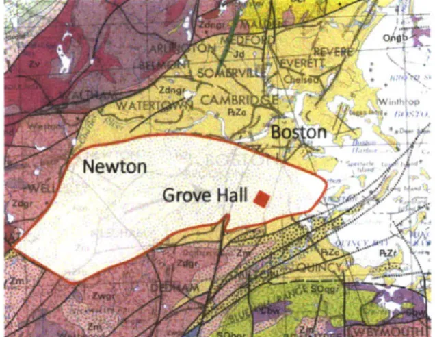
Grove Hall is a neighborhood straddling the surreptitious boundaries of Roxbury and Dorchester - two sections in the southern part of the City of Boston. Once independent towns, Roxbury and Dorchester have grown as a physically and socially integral part of the city since being annexed, in 1868 and 1871 respectively. Grove Hall is identified as the area centered about Blue Hill Avenue, Warren Street and Washington Street. Though not defined with any specific borders, the
neighborhood is geographically within the 02121 zip code based at the 'Grove Hall post office', and is technically contained within five U.S. census tracts1.
1 U.S. Census tracts 820, 821, 901, 902, 903 (as of 2010)
The Art of Cross-Writing in Grove Hall
Origins of this Thesis
This thesis resulted from a question of neighborhood identity. It emerged from research of the neighborhood, and specifically of the transition between the Jewish and black communities within it. Delving into the dynamics of population
transition and the dramatic transfer of physical space from one group to another led to more specific questions about how the urban form of the neighborhood facilitated this process.
Suburbanization, white flight and racial segregation are commonly accepted as part of the inevitable course of urban American history in the mid-twentieth century. In Boston, these forces set forth actions that fueled the movement of over 70,000 Jewish residents and facilitated the transition of the neighborhoods adjoining Blue Hill Avenue to an almost
exclusively African-American demographic. Many factors explain the transition of Blue Hill Avenue, including the demand
for housing by the growing black population, bank lending policies and de facto racial segregation, and the upward mobility
in the Jewish community that coincided with the draw to the suburbs (Gamm 1999; Levine and Harmon 1992; Clay 2012).
Jews, who had been very urban as a community nationwide, were suddenly amongst the most mobile ethnic groups
within the white flight to the suburbs (Gamm 2013). Even though the Jewish community was physically entrenched in
Grove Hall, with a range of synagogues, schools and cultural facilities, they were not bound to a parish system like the Catholics, nor did they have any sacred attachments to a local temple (Gamm 1999). Their center of community was constantly in motion, from the moment they arrived in Boston, through the present day.
The forces of change that fostered the eventual separation of the black and Jewish communities had the initial effect of bringing them together. Despite the factors that created separation, this thesis also finds the brief period during the transition of Grove Hall when African-Americans and Jews lived, worked, studied and played in the same place before a complete racial turnover swept through. Blacks and Jews shared Grove Hall; there were two sets of homeowners, two sets of storekeepers. They occupied and used the same public spaces, though not necessarily together nor for the same purpose. This overlapping of people in place is a unique interim piece of history that has been overshadowed by the end
result of the transition period in which it occurred.
Introduction
The public realm that tied the Jewish and black communities together was Blue Hill Avenue. The street is the central component of a corridor of settlement that extends from Downtown Boston through Roxbury and Dorchester, and that
grew with the extension of streetcar lines. Jews came to Grove Hall at the top end of Blue Hill Avenue from other parts
of Boston as early as 1900. Gradually they settled down the avenue as far as Mattapan. When the Jewish 'era' on Blue
Hill Avenue ended, the community dispersed largely within socio-economic constraints. Wealthier residents moved to
Brookline and Newton, many orthodox Jews moved to Brighton, and the majority of middle class residents continued along the Blue Hill Avenue trajectory into the suburbs of Canton, Stoughton, and Sharon2
Back at the northern end of the street, the incoming black community expanded southward from Lower Roxbury starting in the 1930s and in greater numbers fueled by the incoming southern migration in the 1940s, 50s and 60s.
The transition, when measured in simple census numbers, appears to be linear - one population replaced another and
the neighborhood changed. On the ground, however, the dynamics were much more complex. The black and Jewish communities encountered each other throughout a lengthy transition period. Different people who had not lived together
in the past were now accidental neighbors, their territory became shared space.
The demographic transition is now mostly associated with class and racial tension, however, there were several instances when the communities were adapting rather than reacting. The story of black children learning of the Holocaust from the
tattoo on the grocer's arm, of political gatherings of Jews and blacks in triple-decker homes, and of a black woman who
knew only of Kosher meat growing up highlight the more meaningful ways in which the two communities overlapped3.
How did Blue Hill Avenue exist as a Jewish and black neighborhood, as opposed to the two separate identities (Jewish then black) that are generally attributed to it? This piece of history is missing from the greater puzzle.
At the end of the transition, at some point in the 1960s, the Jewish community basically severed all physical and social connections with Grove Hall, even if they kept emotional ones strong. By the end of the transition, the organization of the neighborhood transfer could not be characterized as smooth. The black community encountered physical problems with 2 The Jewish community moved to many other neighboring towns and suburbs in fewer numbers. The most significant Jewish communities (in terms of
popula-tion) are mentioned in this text.
3 Carter, Marisa. Personal Interview, February 25, 2013.
The Art of Cross-Writing in Grove Hall
the housing and institutional spaces they received, and did not take control of the commercial or social service sector of
the neighborhood. A majority of businesses remained Jewish-owned even as the Jewish residents migrated outward. As well, many of the social services were provided within the Jewish community itself, and moved out with that population. Jewish homes became black homes and synagogues were converted to churches, but the commercial and public space of Blue Hill Avenue did not become the heart or spine of the new black community. Rather, it would become a symbol of its troubles.
Several factors can help explain this failure, though none necessarily create a causal argument. Firstly, the demographic
change was both cultural and socio-economic. Initially a middle and upper-middle class black population joined a Jewish population of similar income level (Gamm 1999, U.S. Bureau of the Census 1940), but with the increased Jewish emigration from Grove Hall in the 1950s and 60s, a larger lower-income black population with a great demand for housing arrived as
well. Secondly, by 1965, 55% of the black population in Boston was southern-born, and generally from a rural and poor
background4
. This was for all practical purposes an immigrant community, even though it was an internal migration'. Finally, the speed and nature of the transition was not conducive to building a stable community. The Jewish neighborhood developed over many decades and several generations. The black community, the majority of which were newcomers to Boston, had within a decade took the reigns of a neighborhood, that although "physically complete" was not necessarily compatible with their culture, religion, or economic status. The neighborhood for all intents and purposes was built for a
Jewish community; the space had to be reconfigured to a new society.
Lastly, Blue Hill Avenue as a transportation artery was experiencing great changes just as the demographic transition emerged. The streetcars were removed and replaced by trolley buses in 1949, and a heavy increase in automobile traffic from the southern suburbs converged in the area of Grove Hall as a result of the road network connecting the city outward
in a radial form6. Small local businesses, geared for streetcar (and pedestrian) access, were not designed for automobiles.
Many garages and gas stations were erected in the neighborhood, including the site of the original streetcar terminal of
Grove Hall. 4 Dobbin et. al., 34.
5 Ibid., 40.
6 Warner, 1961; , 1978
Introduction
The transition period was compounded with layers of social and physical interaction to create new neighborhoods in
place of the old. The demographic transition of Blue Hill Avenue from Jewish to black, and the dramatic change in the use of urban form did not happen in a vacuum, nor did it occur overnight. It was a gradual process spanning decades, and
culminating in a time of intense social change in American cities.
Blue Hill Avenue
Blue Hill Avenue was a peculiarly vibrant urban environment central to several Boston neighborhoods in the first half
of the twentieth century. The commercial presence was sufficient for locals to never leave for, as one resident says,
"everything you needed was on Blue Hill Avenue"7. All the food, drugstore supplies, clothing, and entertainment you
needed was available in the neighborhood'.
From its twisting narrow start in Upper Roxbury and Grove Hall, to a broad one hundred and twenty foot wide boulevard
along Franklin Park and the western edge of Dorchester, and finally into a village-like atmosphere in Mattapan, Blue Hill
Avenue was uniquely identified as the heart and spine of Jewish Boston. The street, over four miles long, was essentially
the community center and commercial zone for Boston's Jewish community up to the 1960s9. The street featured Kosher
butchers, bakeries and delicatessens, sometimes a synagogue, pool hall or cinema. On its sidewalks, children ventured for ice cream or sodas after school and played on corners while crowds waited for streetcars that rumbled down the center
of the road.
Then, from the late 1960s onward, Blue Hill Avenue entered a wave of decline, and its neighborhoods, from Grove Hall in the north to Mattapan at the city's southern border, became typical examples of urban decay amidst a shrinking
population and great economic disinvestment. Even into the start of the twenty-first century, Blue Hill Avenue was still lined with scenes of abandonment, barren sidewalks and spaces devoid of almost any social gathering. It became a very busy thoroughfare, associated with social malaise, and laden with a troubled sense of identity to the residents who called it home.
7 Lurie, Hal. Personal Interview, 24 March 2013.
8 Ibid.
9 Gamim, 1999; Sarna, 1995.
The Art of Cross-Writing in Grove Hall
Optimism
Recently, however, signs of interest and renewed investment by the city, residents, church and mosque leaders, community
development corporations (CDCs), as well as local and regional private investors, are providing Grove Hall a new sense
of optimism. A reversal to decades of abandonment and decay is currently taking place. In this process, new building
construction, new public places, improved park space, and the return of cultural events are latching on to the historical urban form. The streets and buildings from the past are bearing witness to a new layer in the making of history in the neighborhood.
At first glance, Grove Hall appeared to me a troubled neighborhood and a neglected part of the city. However, over the course of my research, on my numerous walks along Blue Hill Avenue and its side streets, I discovered the businesses, the street conversations, the kids getting ice cream from the corner store, the fathers taking their sons to get haircuts at one of
the dozen or so local barbers, the skateboard shop, the music from the local radio station blasting onto the street: a vibrant
community. There is a similarity in the black scenes of 2013 to the Jewish nostalgia I hear of 1943.
The following chapters are presented through a set of select narratives that guide the reader through several stories and dimensions of the neighborhood. They compose a passage through two hundred years of formal development, through
two communities (Jewish and black), through almost a dozen architectural styles, through social upheavals that dictated
the course of mid-century American urban history (suburbanization, white flight, and the civil rights era), through the period of decline, and now one of revival.
The thesis is informed by several texts on the subject of Jewish and black migration and settlement in Boston (Gamm, 1999; Sarna, 1995; Edward, 1961; Dobbin et al., 1968), as well as books and articles discussing the phenomena of white flight, race riots, suburbanization and place identity (Aldrich, 1975; Fishman, 1961; Goering, 1978, Jackson, 1985; Pettigrew,
1969; South et. al., 1998). There was also in-depth research of street development, architectural styles and the design of Franklin Park, as I understood these particular issues to be most important in developing a theory of place specifically influenced by form in Grove Hall.
Introduction
A series of "mapping vignettes" are presented in Chapter One to help explore the relationship and evolution of physical form within three important locations in the neighborhood (the 'Grove Hall' estate, the 'Little' estate, and the West End Street Railway site). These maps capture the process of development and help demonstrate its influence on street design,
architecture and society within the neighborhood.
Finally, the work is based on ten months of neighborhood observations, interviews with over twenty residents and former
residents, discussions with city officials, community development corporations and business owners. A more detailed discussion of the research methodology is presented in the Appendix.
Organization
This thesis is organized within a chronological history spanning two hundred years of construction, immigration, transition and neighborhood decline in Grove Hall (Part I - Foundations), and a review and analysis of the revival, or resurrection, of
urban form since the end of the twentieth century (Part Il - Revival).
Part I
Foundations
Chapter One, Follies in the Park: Puddingstone, Olmsted and the Suburbanization of Grove Hall examines the
original development of the neighborhood, from the first roads to the first streetcars, and the transformation
from rural land to suburban habitation.
Chapter Two, Mezuzahs and Soul Brothers: Jewish and African-American communities on Blue Hill Avenue
studies the two major communities that call (or called) Grove Hall home. It reveals their relationships with
the physical neighborhood, and the overlapping period they inhabited together in the mid-twentieth century.
Chapter Three, Plywood on the Corridor: The Abandonment of Blue Hill Avenue, starts at the end of the transition period between Jews and blacks, and covers three decades of economic and physical decline in
Follies in the Park
Puddingstone, Olmsted and the Suburbanization of Grove Hall
What are those lone ones doing now,
The wife and the children sad? Oh, they are in a terrible rout,
Screaming, and throwing their pudding about,
Acting as they were mad.
They flung it over to Roxbury hills, They flung it over the plain,
And all over Milton and Dorchester too Great lumps of pudding the giants threw; They tumbled as thick as rain.
Giant and mammoth have passed away,
For ages have floated by;
The suet is hard as a marrow-bone,
And every plum is turned to a stone,
But there the puddings lie.
And if, some pleasant afternoon,
You'll ask me out to ride, The whole of the story I will tell,
And you shall see where the puddings fell, And pay for the punch beside.
The Art of Cross-Writing in Grove Hall
Fig 1.1. Boston-area geologic structure showing
location of Puddingstone foundation. Source: U.S. Geological Survey.
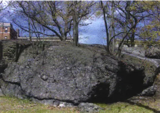
Puddingstones
The giant sedimentary stone formations found amongst the Queen
Anne homes on Elm Hill Avenue, in purple and grey hued ledges perched
above Seaver Street, and scattered about wild patches of Franklin Park
are outcroppings of the ancient geological foundation of Roxbury.
"Puddingstone" is the popular term given to the conglomerate rock
composed of pebbles, granite, boulders and quartz embedded in
cement-like sandstone
1. The coining of the term is attributed to either Oliver
Wendell Holmes or British geologists in the early nineteenth century,
who likened the appearance of the rocks to "Christmas Pudding" - an
English cake with mixed fruit pieces
2. The moniker is widely accepted in
geological circles worldwide. Roxbury Puddingstone (the local variant)
is found in areas south and west of Downtown Boston, and forms the
bedrock for much of the neighborhoods of Roxbury, Dorchester and
Jamaica Plain, as well as Brookline and part of Newton (fig 1.1).
Fig 1.2. Pangaea Continent.
Source: http://www.glosgeotrust.org.uk Avalonia 1 Skehan, 1975. 2 Ibid. 24 ... .. .... ... ... . .. .... . .... : ... ...
Follies in the Park
The rock was formed over 500 million years ago during volcanic eruptions on Avalonia, a
pre-historic island chain that moved by continental shift from its original location adjacent to ancient Africa to its current position in New England (fig 1.2). The Puddingstone typology, though not unique to Roxbury, is similar in composition to only a handful of places on the planet, including England and western Africa. Much of the rock now visible in Roxbury was exposed to the surface by glacial striations in the last ice age3.These produced open rock formations, exposed cliffs, and
polished boulders strewn on the landscape.
In addition to the poetic and symbolic attributes of Roxbury Puddingstone (it is also the Massachusetts "state rock" and the origin for the naming of "Roxbury"4), the outcroppings served
three major physical roles in the development and identity of Grove Hall. Firstly, its large mounds and cliffs created obstacles that determined the route of several roads including Seaver Street, Walnut Avenue and Blue Hill Avenue, where alignments and curves are clearly defined by the presence of the rock (fig 1.3). Secondly, although much of the bedrock in Grove Hall was paved over or built upon, many unique formations and boulders were too large to move or preserved
for their majesty. They can be seen in places like Horatio Harris Park (fig. 1.4) and Puddingstone
Park.
3 Hatch, 1991.
4 "Roxbury" is a deviation from the original name "Rocksbury" bestowed on the town in recognition of the many rocks on or under the surface.
Fig 1.3. Puddingstone south of Seaver Street in
Franklin Park. Photo by author.
25 . .. .. ... -- -- __
The Art of Cross-Writing in Grove Hall
Fig 1.5. Abbotsford House, 300 Walnut Avenue,
Roxbury. Photo by author.
Fig 1.6. Roxbury Presbyterian Church
Photo: Google Earth
Lastly, Puddingstone was used in the construction of a number of
buildings, mansions, churches, fences and bridges in Roxbury and across the Boston area. Blocks were chiseled for walls and fagades, spires and steps. Some notable examples in, or on the edge of Grove Hall include the Abbotsford House - now the Museum of the National Center for Afro-American Artists (NCAAA) on Walnut Avenue (fig. 1.5), the Roxbury Presbyterian Church on Warren Street (fig. 1.6), and the Tremont Street Methodist Church. Rock was either sourced directly on-site, or from one of the commercial quarries located in Roxbury'. During the construction boom of detached homes that dominated Grove Hall in the late nineteenth century, even as wood was the standard building material, Puddingstone was widely used for foundations, and is visible at the base of many homes.
On this rock foundation, several layers of road, rail and park space prepared the surface for the physical form that led Grove Hall into the
twentieth century.
5 Quarries are recorded at Parker Hill in Roxbury (Puddingstone Park), in the Arnold Arbore-tum, and Nira Rock in Jamaica Plain (http://www.nirarock.org)
26
Follies in the Park
Roads
The evolution of street design and infrastructure in Grove Hall and Franklin Park, and the creation
of three roads in particular, had a major influence on the speed and pattern of the development
of the neighborhood.
The paths of these main arterial roads and the course of development they determined
are responsible for the general organization of the built form in Grove Hall. In order of their
construction they are (1) the Way to Braintree (also referred to as the road to Plymouth, or
Quincy), (2) Brush Hill Turnpike, and (3) Seaver Street (figs. 1.8, 1.10, 1.13 on pages 27, 29, and
31). The location and subsequent intersections of these roads initiated and supported residential
and commercial development, and determined future transportation routes, land use, density
and identity.
The Art of Cross-Writing in Grove Hall
Fig. 1.7. Grove Hall. Federalist (or Federal)-style mansion.
Soure:- Boston Public Library.
The Way to Braintree and the Origins of Grove Hall
The first road to Braintree, Quincy and Plymouth was forged south from the village of Roxbury in
1663 along the high ridge line overlooking Dorchester Bay
6. Its route can be traced to an adherence
of topographic contours, and was calculated to reach the first narrowing on the Neponset River
that was suitable for a bridge crossing (at the southern end of Dorchester.) This road became
Warren Street in Roxbury and Washington Street
7in Dorchester (fig 1.8).
Over time, agricultural estates were located along the length of the road, including that of
Thomas Kilby Jones
8on the border of Roxbury and Dorchester. The Jones estate was established
in 1800, dotted with apple and pear orchards and a large mansion that commanded a clear view
of Boston, the bays and the distant Blue Hills'. Following an old British tradition, the estate was
given a formal name: "Grove Hall"
10(Fig 1.7).
Grove Hall engaged the design vernacular of many estates at the time, gently breaking from
the British-dominated architecture embedded during the colonial period. Virginia and Lee
McAlester (1994) survey the search for new styles in defining American architecture in their book
on American houses. As they describe, the first move to design independence was a shift from
the contemporary Georgian style to the "American Federalist style" at the end of the eighteenth
century".
To achieve the new vernacular, local architects such as Charles Bullfinch made subtle changes and
additions to Georgian form, creating pronounced exterior columns, reshaping rectangular
cham-bers to oval, square and half-octagon, and adding the trademark 'fanlight' above entry doors.
6 Drake, 199.7 There are four 'Washington' Streets in the City of Boston. To distinguish between them, their neighborhood is mentioned. In this thesis, 'Washington Street' refers to the street in Dorchester, between Blue Hill Avenue and Dorchester Avenue.
8 Thomas Kilby Jones was a Boston merchant who had purchased the land and established an eleven acre country estate.
9 As per the view described by Boardman, 1874. 10 Drake, 222.
11 McAlester, 44.
12 Ibid. Fig. 1.8. "The way to Braintree*
28
... ... _ : ... ... . ... ...
The Art of Cross-Writing in Grove Hall
The Grove Hall federal-style mansion faced the Way to Braintree and was centered on a grand
semi-circular carriage path. It was not the largest estate in Roxbury, nor the oldest, but its manor stood
as a prominent piece of architecture and, more importantly, the estate was a pivotal component in
place-making and identity in the neighborhood that would bear its name. Although there are no physical remnants of the actual buildings of the old estate, the impact of Grove Hall was absorbed in the form of the roads that eventually surrounded and dissected it, and in the placement and design typology of the subsequent structures that were built over it. The continuation of the evolution of the Grove Hall estate is documented in Mapping Vignette no. 1 on pages 32-33.
Brush Hill Turnpike
Shortly after Grove Hall was established, a new road was planned to connect the towns of Canton and Milton with Boston via Roxbury (fig. 1.9, 1.10). The Brush Hill Turnpike was planned in 1805 and opened in 1809 forming the route of present-day Blue Hill Avenue". Similar to other new roads built in this period, such as the Dedham and Dorchester Turnpikes, long segments were built towards
their destinations using straight alignments rather than conforming to topography or with concern for hydrological constraints14. The Brush Hill Turnpike included a two-mile long straight segment from just above the village of Mattapan north to a junction with Warren Street, adjacent to the Grove Hall estate. The street axis was drawn just east of a large outcropping of Puddingstones south of Grove Hall and skirted the east side of Wellington Hill1s in Mattapan.
The original plan of the Brush Hill Turnpike included an extension along the Way to Braintree (Warren Street) north toward Lower Roxbury16. For economic reasons, the road stopped short, and ended at
13 Note that the former "Blue Hill Turnpike" built to the east of the Brush Hill Turnpike is present-day Randolph Avenue in the town of Milton; Wood, 117.
14 As illustrated in maps and plans for the these roads in the early nineteenth century.
15 Wellington Hill is a drumlin - a rounded glacial landform created in the last ice age.
16 Whitney, charles. Map of the Town of Roxbury. 1843; "Plan of Boston and Roxbury," 1867.
4Fig.
1.9. Kendall, Jonas. Manuscript of Brush Hill Turnpike,1806. Fig. 1.10. "Brush Hill Turnpike" (Blue Hill Avenue)y
30
The Art of Cross-Writing in Grove Hall
Fig. 1.11. Map of the Town of Roxbury, 1843.
Source: Norman B. Leventhal Map center, Boston Public
Library.
Fig. 1.12. "Plan of Boston and Roxbury," 1867.
Source: Massachusetts Historical Society.
f 8 r
an intersection in Grove Hall. As early as 1843, an extension of the road was made north of Grove
Hall to Dudley Street. Originally called "East Street", then "Grove Hall Avenue," the lower and upper segments were united as "Blue Hill Avenue" in the 1870s (fig. 1.11, 1.12).
Importantly, there is a slight yet obvious curvature planned on the original road where it abuts the Grove Hall estate. This form results from the route avoiding two structures on the estate. Those structures were removed toward the end of the nineteenth century, and Blue Hill Avenue was widened onto estate land between 1887 and 1895, but the curvature of the road endured. This deviation from an intentional form in the street pattern exemplifies the way historical precedents influenced form in local street design. In stretching the correlative effects of this curve and the estate that formed it, the consequences of the accompanying historical development are traceable in the current gap in commercial space that exists between Washington Street and Seaver Street/Franklin Park. The Grove Hall estate affected development patterns for over a century, and though entirely destroyed by the 1930s, the residual effects of its presence and control still linger in the physical and social fabric.
Seaver Street
The third major influential road of Grove Hall was Seaver Street (fig. 1.13). Built as a path named the "Long Crouch" shortly after the completion of the Brush Hill Turnpike, it connected the area around Grove Hall with Walnut Avenue and eventually Egleston Square along the southern edge of the estate of Ebenezer Seaver". The roadway skirted the northern edge of some of the larger Puddingstone formations found in the area. Seaver Street was a crucial component in the original division of Roxbury into separate towns and, as will be seen below, greatly influenced the future of land development in the area.
17 Drake, 223 Fig. 1.13. Seaver Street
Mapping Vignette no. 1
Grove Hall Estate
The estate of Thomas Kilby Jones is trans-formed into a vacation home in the mid-19th century
The area is sparsely developed, mostly the realm of agricultural estates
Brush Hill Turnpike curves around estate
Area around the estate begins to develop with
the arrival of streetcar service
Churches built opposite estate grounds
Consumptive's home rebuilt at south end of estate property
Fire Station erected on Washington Street
Blue Hill Avenue widened between Seaver Street and Washington Street
1887
. .... . .. ... ... . . ... ... ... ...... ...
First apartment blocks are built on Castlegate
Road
Apartment buildings continue to form the northern end of the former estate
1906 1918
All apartment building and retail buildings are completed on site
1931
The Art of Cross-Writing in Grove Hall
Secession of West Roxbury and the Seaver Street Frontier
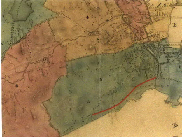
In 1851, the Town of West Roxbury, which included the villages of Jamaica Plain, Roslindale and old West Roxbury, "separated itself from its parent city of Roxbury" in an attempt to "preserve its former rural character against the coming of modern municipal life18" (fig. 1.14).
The eastern segment of the new border between Roxbury and West Roxbury was drawn on Seaver Street. This line effectively created a physical limit to development at the time, and to a degree prompted that very development into action. Beginning in the late 1860s, the rural estates north of Seaver Street, including the Williams, Reed, Weld and Seaver estates, were systematically subdivided into residential side streets and individual private lots19. A haphazard patchwork of roads was drawn over the fields and wooded hills20. The development of detached
homes generally started in the north closer to the urban area at Dudley Square and spread south
toward Seaver Street. Fig. 1.14. Map of Boston (showing Roxbury, West
Roxbury, Dorchester divisions),1874.
Fig. 1.15. "Map of West Roxbury [Franklin] Park", 1876.
18 Lower Roxbury, centered around Dudley Street, was by the 1850s a well-developed sub-center to Boston. Dense population, and growing commerce and manufacturing enterprises were poised to generate sprawl south into the rural highlands of Roxbury; Warner 1978, 42.
19 Plan of Boston and Roxbury, 1867; Atlas of the county of Suffolk, MA, Vol. 2, Roxbury, Plate H, 1873. 20 As per the description of the area in Boardman, 5-6. Drake, 1878
36
Follies in the Park
The transition from rural agricultural estates
to tracts of suburban homes did not progress in a linear pattern. Some streets such as Wayne, Schuyler and Maple preceded
development closer to the city (fig 1.15). Old estates were subdivided and housing was developed incrementally over the span of years, sometimes decades. During this time the owners (or their heirs) continued to live in the original manors or in new homes on portions of the former estates21. In the 1870s, there emerged a scattered pattern of Queen Anne (fig. 1.16) and Second Empire (fig
1.17-1.18) style homes amidst vast apple orchards
and arrays of greenhouses. The rural landscape of Grove Hall with its fruit strewn wooded hills lay directly in the path of nineteenth century
suburbanization.
21 The Seaver estate included the land between Blue Hill Avenue and Elm Hill Avenue, Georgia Street and Seaver Street. By 1895, the area was subdivided into 94 separate lots, with all large parcels, and many smaller ones owned by the members of the Parker family, heirs of Ebenezer Seaver. (sources: Atlas of the County of Suffolk, MA, Vol. 2, Plate H, 1873; Bromley Atlas, Plate 39, 1895)
Fig 1.16. Queen Anne
Streets like Warren, Humboldt, Howland, Craw-ford, Maple and Waumbeck were an experimen-tal building ground for the 'Queen Anne' style. A free-form Victorian variation, the Queen Anne typically included playful roof lines, rounded cor-ner bays, wrap-around porches, turrets, balco-nies and careful attention to color applied with customized design and details for the wealthier new residents (McAlester, 164-165). This style was short-lived, but used profusely in Grove Hall, Roxbury and throughout the region between
1870 and 1890 (Ibid). Photo: Howland Street, by
Author
Fig. 1.17. Second Empire
The Second Empire, Victorian era style imported from Paris. It is characterized by mansard roofs and protruding bays and porticos (McAlester,
136-137). It was employed in the Boston area for
homes, civic structures and apartment buildings, including many in Grove Hall such as the Highland Street Railway Terminal building, and this house
on Warren Street. Photo: Google Earth.
37
The Art of Cross-Writing in Grove Hall
Fig. 1.18 Highland Streetcar Terminal, Grove Hall, 1881.
Source: Sammarco 2007, 51.
Fig. 1.19 "Old Little Estate, Warren St., Roxbury", 1885
(approx). Source: Boston Public Library/Folsom,
Augus-tine H. (photographer). 10 Nov 2010. Online Collection.
Flickr. 12 April 2013.
Arrival of the Streetcar and the Subdivision of the Little Estate
Arguably, the greatest determinant for the location of urban and suburban growth in the
Boston area in the final decades of the nineteenth century was the accessibility provided by
the new streetcar system
22. Sam Bass Warner's "Streetcar Suburbs (2nd Ed.)" (1978) provides a
comprehensive history of development in Roxbury and Dorchester including many descriptions
specifically of Grove Hall". The first streetcar route into Grove Hall was operated by the Highland
Street Railway Company (HSR) on Warren Street in 187224. The route originally terminated in
Grove Hall, but was extended to Four Corners in Dorchester by 187325. The streetcars prompted
wide-scale construction of middle-class suburban homes
26.By 1880, between the roads, streetcars
and new home construction, the physical framework of the neighborhood was forming.
The incorporators of the HSR included the owners of local estates who would seemingly benefit
from the development of their land. Mr. Samuel Little was the treasurer of the HSR
27. Little's
estate was located between Warren Street and Blue Hill Avenue, below Gaston Street (fig. 1.19).
The first streetcar line on Warren Street passed directly in front of the estate. Aaron White and
Patrick Maguire first developed single family homes on their land north of Little, with the creation
of Gaston and Carlisle streets. The owner of the estate neighboring to the south was Theodore F.
Tillinghast, whose land included would become Brunswick and Intervale Streets.
22 Warner, 1978.
23 Ibid.
24 The Highland Street Railway operated the first line to Grove Hall from Boston via Dudley Square. It added additional lines on Columbus Ave., Dudley Street and Blue Hill Avenue. Mass. Board of Railroad Commissiones (1874): 140.
25 Atlas of the Country of Suffolk, MA, Roxbury, Plate H, 1873.
26 Warner 1978, 49.
27 Mass. Board of Railroad Commissioners (1887): 338.
38
Follies in the Park
4
Fig. 1.20. Boston Elevated Railway Lines, 1925.Fig. 1.21. Streetcar on Blue Hill Ave. looking north at Washington St., 1932
Source: Sammarco 2007. 55.
Grove Hall
39
A
Mapping Vignette no. 2
Samuel Little Estate: Elm Hill Park and Otisfield Street
1887 1854
ee
7j ' q1' / 7/' 7 1897 1919 I,-_The estate of Samuel Little was subdivided multiple times leaving a trace of its history in the street patterns of Otisfield Street, Gaston Street, Intervale Street and Elm Hill Park.
The location of buildings and fences, separation of typology and
of fate were all determined by the unplanned nature of this site.
This vignette is an abstract rendering of past and present forms, but attempts, through mapping across time, to make sense of the boundaries that exist in Grove Hall today.
The Art of Cross-Writing in Grove Hall
Consequences of Development Patterns
No structured plan was engaged in the creation of the neighborhood form. The order and pattern of development derived
from the former estate boundaries and the timing by which the owners decided to sell their land. In many cases, land
speculators, or the estate owners themselves, bought or reserved parcels and delayed their development for years whilse homes were erected on adjacent properties. By enduring a lapse in development, Grove Hall was subject to an array of different architectural styles, often on the same block.
Annexation
Roxbury was annexed by the City of Boston in 1868, at which point Seaver Street became part of the new southern border
of the larger city.
In 1874, West Roxbury was annexed as well, ending its hope of evading urbanization. However, in the twenty years that Seaver Street provided a boundary to West Roxbury, it managed to curtail the subdivision of properties and prevent housing development on the south side of the street. This action in effect had a major consequence on the future of open space planning in Boston. Under the leadership of Mayor Samuel C. Cobb, the significantly enlarged City of Boston determined there was an urgent need for the creation of park space. The "Boston Parks Commission" was created by the Municipal Park Act of 1875 and charged with establishing a master plan for new civic park space in the city2
.
As the innermost sections of the city were already developed or under development, new parks were generally planned for
newly annexed areas. The Boston Parks Commission engaged Frederick Law Olmsted as their consultant. Having recently designed Prospect Park in Brooklyn and Central Park in Manhattan29, Olmsted was the preeminent public park designer of
the time. He returned with a general plan for a ring of parks along the western edge of Roxbury30, Jamaica Plain and across West Roxbury. The "Emerald Necklace" was conceived" - a contiguous series of parks beginning at Commonwealth
28 "Boston Park Act", Acts of 187S, chapter 18S.
29 Prospect Park was designed in 1867 and central Park in 1857, and both still in the long process of construction when the design of his Boston parks began.
30 The western part of Roxbury at the time of annexation included part of the present-day Back Bay (considered a central Boston neighborhood). The former boundary ran between Gloucester and Hereford Streets.
31 The Back Bay was a filled in expansion of Boston, begun in 1857.
Follies in the Park
Avenue in the Back Bay, meandering toward the Arnold Arboretum32 and culminating in a new 527-acre city park near
Grove Hall33 (fig. 1.22).
Seaver Street, the former southern boundary of Roxbury, then of Boston, was now employed to define the northern
border of "Franklin Park". The effort made through the secession of West Roxbury to preserve rural land3 would be
marginally realized in the location of Olmsted's new park.
32 The Arboretum, owned by Harvard University, was created in 1872 by F.L. Olmsted, and subsequently incorporated in the Emerald Necklace.
33 The original necklace also included a "Dorchesterway" boulevard connecting Franklin Park to South Boston, but was never built.
34 The goal of West Roxbury's secession and of Olmsted original design for Franklin Park was to preserve rural landscapes as they existed at the time.
Fig. 1.22. Emerald Necklace, 1875
Source: Olmsted Archives
The Art of Cross-Writing in Grove Hall
44
Follies in the Park
Franklin Park
The great open vistas of Roxbury and Dorchester seen by Oliver Wendell Holmes almost two centuries ago, are now mostly incorporated into the dense development of the city of Boston. However, one significant remnant of the old landscape (though physically altered from its natural state) exists in Franklin Park (fig 1.23).
Cynthia Zaitzevsky (1982), in her historic volume "Frederick Law Olmsted and the Boston Park System," chronicles the planning process and construction of Franklin Park and the Emerald Necklace, including discussion of Olmsted's visions and philosophies. Zaitzevsky describes the efforts Olmsted made toward preserving rural qualities in the park, and in creating a place of refuge from the "ills of urban life" that were growing with the city.
Puddingstones and park
There is a powerful relationship between Puddingstones, Franklin Park and the development
of the Grove Hall neighborhood. Franklin Park, opened in 1885, helped frame the emerging
'streetcar suburb' in Grove Hall by providing a solid boundary for the neighborhood as well as a
degree of physical orientation. The social and cultural demands of the surrounding communities influenced the programming, design and evolution of the park. Within this period, Puddingstones
were in part a physical determinant and in part a natural inspiration for both neighborhood and park; providing physical building blocks and a unique visual identity. Many boulders are exposed throughout the park, and Puddingstone was used to make fences, steps, gateway arches and even some buildings.
Fig. 1.23 Frederick Law Olmsted, "General Plan of Franklin Park" 1885.
Source: Norman B. Leventhal Map Center, Boston Public Library
"A man's eyes cannot be as much occupied as they are in large cities by artificial things, or by natural things seen under obviously artificial conditions, without a harmful effect, first on his mental and nervous system and ultimately on his entire constitutional organization." - Frederick Law Olmsted ("in Notes on the Plan of
Franklin Park and Related Manners")
(Olmsted, 42)
45
.
The Art of Cross-Writing in Grove Hall
Fig. 1.24. Ninety-Nine Steps, Franklin Park
Source: Franklin Park Coalition
Fig. 1.25. Schoolmaster's Hill, Franklin Park
Source: Franklin Park Coalition
Olmsted instilled poetic meaning in the place-making of Franklin Park. In the "Ninety-Nine Steps,"
and "Schoolmaster's Hill35" for instance, he designed meandering pathways and classical ascents
to engage the participant in a voyage to nature (figs. 1.24, 1.25). His philosophy of being immersed in nature and escaping - even temporarily - from urban living, led Olmsted in attempting the design of an overtly rural setting. The encroaching suburban development of Grove Hall, however,
placed competing programmatic requirements on the park.
Although bordered by many neighborhoods in Dorchester, Mattapan, and Jamaica Plain, the most historically symbiotic relationship of the park lay with the Roxbury neighborhood of Grove Hall. Franklin Park and Grove Hall developed in tandem from 1885 through the early 1900s. The design of the park responded to this neighborhood with a set of programs and formal spaces absent on other edges. Olmsted treated the Grove Hall side of Franklin Park in a completely different manner. Adjacent to the Seaver Street edge, an urban "ante-park" was designed in contrast to the "country" or non programmed36 sides touching other neighborhoods37.
Essentially two parks were created in one, a dichotomy that would endure much friction over the course of the park's history. The suburban, eventually urban, reality surrounding the park failed
to adhere to Olmsted's theory of rural escapism. Additional demands were put on the expansive park grounds, and elements of the "country" side eroded after the opening of the park. This included, but was not limited to, the creation of the golf course, and the entry of vehicles to the park grounds.
In the "ante-park", Olmsted designed the "Playstead" - a sporting ground specifically for children, a playground, an informal zoo (with only native "hardy" animals), and a grand public space called "The Greeting"3
35 Named in honor of Ralph Waldo Emerson who lived in a house formerly located in the park (Franklin Park coalition, 1980, 2)
36 Olmsted's original design included non-programmed spaces, but a large golf course was then built near the Dorchester and Mattapan edges.
37 Zaitzevsky, 1982
38 lbid; Boston Park commissioners, 1910
46
Follies in the Park
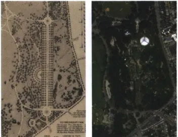
The Greeting
Olmsted's "Greeting" included a grass and sand-bedded promenade
lined with Elm trees, roughly half a mile in length; a setting for residents
to gather, stroll, enjoy performances of music and play into the night
39.
Its design was comparable in both scale and form to Rotten Row
in London
40- the great bridle path of Hyde Park. Though integral to
Olmsted's
final plan, construction of the original Greeting was constantly
delayed, and eventually shelved by the City in 1900".
The grand promenade design was not completely lost, however, as the
landscape architect Arthur Shurcliff, a disciple and former employee of
Olmsted, used basically the exact location and geometry of the Greeting
for the design of the new zoo grounds that opened in 1912 (fig 1.26).
A few adjustments were made: the promenade was narrowed, and in
addition to the planting of Elm trees, the promenade was lined with
animal pavilions
42. The zoo and Greeting were open free and unfenced
to the public. For the local community and for those arriving by streetcar,
the formal grounds offered a great year-round civic space. The zoo and
the Greeting were in essence the face of Franklin Park at Grove Hall;
their future would, in turn, be influential on the neighborhood, and vice
versa.
39 Zaitzevsky,
40 As per Boston City Council debate about funding its construction in the city council (Boston 1900 Documents, vol 4)
41 lbid
42 Boston Park Commissioners, 1910; Animals were arranged in pavilion-like buildings, such as the pagoda-style bird house (see fig.1.27)
Fig. 1.26 Comparison of Olmsted Plan and actual layout of the
"Greeting" and the zoo.
There are major formal similarities. Though, the original plan has several connections to the park perimeter that do not exist today. As well, the path system in Olmsted's plan was strictly
for walking or riding (cars had not even been invented).
Sources: Olmsted Archives; Google Earth.
47
The Art of Cross-Writing in Grove Hall
Fig. 1.28. West End Street Railways, Grove Hall Car House.
Source: Boston Public Library. Online Collection. Flickr. 27 Feb 2013.
By virtue of the accessibility they provided with the streetcar network4 3, Blue Hill Avenue and
Seaver Street had a mutually constructive association with Franklin Park, though their individual formal relationships would differ greatly. In time, businesses would flourish on Blue Hill Avenue, and make the street into a social and commercial extension of the park and of Grove Hall. On Seaver Street, a high-end residential enclave would evolve. Their intersection, near the apex of the Greeting, became a formally bifurcated corner of Franklin Park. Adding to the complexity of this corner was the great puddingstone barrier on the park side, and the lingering history of the Grove Hall estate diagonally across from it.
The Streetcar Terminal at Grove Hall
The original Highland Street Railway streetcar barn on Blue Hill Avenue occupied a modest, yet stately, second empire building between Geneva Avenue and Centre Avenue (later Central Avenue.) The HSR merged with the Middlesex Railroad in 1886, and the following year with the West End Street Railway Company (WESR), which became the operator of most streetcars in the
city.
By this time, the streetcar network was expanding in Roxbury and Dorchester, including a new line on Blue Hill Avenue from Dudley Street to Franklin Park. The WESR enlarged the depot into a major terminal including a streetcar storage and maintenance facility, a passenger waiting room and a horse stable (until electrification was complete)". Houses built along Central and
Geneva Avenues in the 1860s and 1870s were demolished as the properties were acquired by the streetcar company45.
43 By 1901, Streetcar lines were operating on both Blue Hill Avenue and Seaver Street. In addition, the Columbia Road Streetcar terminated at Blue Hill Avenue at the park entrance, and the Humboldt Avenue Line ended in a loop on the south side of Seaver Street.
44 Bromley 1889, 1904 45 Ibid
Follies in the Park
The emerging Grove Hall transportation hub and commercial node acquired a new scale. The block between Stanwood Street, Geneva Avenue, Normandy Street and Blue Hill Avenue became
one large six acre site, the largest lot in Grove Hall, and one that would have a rippling effect on
the neighborhood for over a century. As early as 1905, the West End Streetcar Company erected a maintenance shed that occupied almost half of the super-block; this was the largest building in Grove Hall, at the time, and ever since.
The effect that the West End Street Railway's consolidation of land had on Grove Hall was two-pronged. At first, the strength of the streetcar facility, and the adjacent commercial and
residential development it spawned created the dense heart of the neighborhood. However, as
we shall see in Mapping Vignette no. 3, the eventual dismantling of the streetcar system created
a large vacancy in the middle of Grove Hall.
Mapping Vignette no. 3
The West End Street Railway Company
Several commercial and streetcar-support industries open adjacent to the streetcar yards The West End Street Railway takes over the former facilities of the Highland Street Railway straddling Central Avenue
Business expands around the 'center' of Grove
Hall
The streetcar facilities expand over majority of
site, removing Central Avenue
The streetcar facilities shrink
The former train shed on Blue Hill Avenue is
converted to a car dealership
Filling station opens in centre of streetcar activity
A new single storey commercial strip is
opened on Blue Hill Avenue
1904 1931
... ... :- : ... .... :- :: ... ... ... . ... ...