HAL Id: tel-02987839
https://tel.archives-ouvertes.fr/tel-02987839
Submitted on 4 Nov 2020
HAL is a multi-disciplinary open access archive for the deposit and dissemination of sci-entific research documents, whether they are pub-lished or not. The documents may come from teaching and research institutions in France or abroad, or from public or private research centers.
L’archive ouverte pluridisciplinaire HAL, est destinée au dépôt et à la diffusion de documents scientifiques de niveau recherche, publiés ou non, émanant des établissements d’enseignement et de recherche français ou étrangers, des laboratoires publics ou privés.
Sensors networks : Application to the tracking of moving
targets
Mustapha Bekhti
To cite this version:
Mustapha Bekhti. Sensors networks : Application to the tracking of moving targets. Networking and Internet Architecture [cs.NI]. Université Sorbonne Paris Cité, 2018. English. �NNT : 2018USPCD092�. �tel-02987839�
Réseaux de capteurs:
Application à la poursuite des cibles
mobiles
Sensor networks:
Application to the tracking of moving targets
Mustapha Bekhti
L2TI /Galilée Institute
Paris 13 University
This dissertation is submitted for the degree of
Doctor of Philosophy in Networks
Supervisors: Dr. Nadjib ACHIR / Paris 13 University Dr. Khaled BOUSSETTA / Paris 13 University Jury: Pr. Nadjib AIT SAADI, ESIEE Paris / Paris Est University
Pr. Steven MARTIN, LRI / Paris Sud University Pr. Hervé RIVANO, CITI / INSA Lyon
Pr. Sidi Mohammed SENOUCI / University of Bourgogne Dr. Lucas LETOCART, LIPN / Paris 13 University
Dr. Marwen ABDENNEBI / Paris 13 University
To my loving parents, to my wife,
to my most valuable treasures my daughters Meriem and Sirine, to my sisters and brothers,
Declaration
I hereby declare that except where specific reference is made to the work of others, the contents of this dissertation are original and have not been submitted in whole or in part for consideration for any other degree or qualification in this, or any other university. This dissertation is my own work and contains nothing which is the outcome of work done in collaboration with others, except as specified in the text and Acknowledgements. This disser-tation contains fewer than 140 pages pages including appendices, bibliography, footnotes, tables and equations and has fewer than 55 figures.
Mustapha Bekhti January 2018
Acknowledgements
It would not be fair unless I thank the Algerian government for financing this thesis for more than three years. My deepest acknowledge goes also to my two supervisors Nadjib Achir and Khaled Boussetta who shared with me their knowledge over these three years. It is because of them I could finish this thesis in the best way. Both of them need a special recognition and thanks, since from the first moment they gave me 100 % support and confidence to make this process an amazing experience and for giving me the tools necessary to finish this work. I would like also to thanks Marwen Abdennebi and Saadi Boudjit for their help and for the knowledges and the time they shared with me. And finally, and since actually she is the most important person in this process, my wife Nadia. Without her constant support, understanding and patience this work would have been impossible to finish.
Abstract
For decades Unmanned Aerial Vehicles (UAVs) are widely used in modern warfare for surveillance, reconnaissance, sensing, battle damage assessment and attacking. The benefits of UAVs include reduced cost and no warfighter risk. In fact UAVs use is increased by time, especially under the concept of the network centric operation environment and under the concept of revolution in military affairs. On the other hand, the UAVs technology which originates from military applications, arouse the interest of the civilian, and yet, the domestic use began with limited aerial patrols of the nation’s borders, disaster and law enforcement situation. Recently, these products have also been destined to the commercial market and have gained much attention. Although UAVs use is expanding, their level of automation, cooperation and integration in civil application is far from being efficient and the design principles of such cooperation, coordination and self-organization under an Ad-hoc network of a multi-UAV still need intensive studies and remain an open research problem.
In this thesis, the investigated tracks were drawn both from the the literature review and from the news topics. Thus, they covered two main classes of contributions, first, path planning and tracking of drones with package delivery and data gathering missions, and second, intrusion detection in a sensitive area through the use of networked drones.
The results show that the integration of the drone segment to the terrestrial wireless network presents a relevant added value and opens new perspectives to the use of this technology in the civilian realm.
Keywords: Wireless network, drone, UAV, mobilty, tracking, planification, trajectoiry, 2D, 3D, obstacle, collision, SINR, package delivery by drone, data gathering, surveillance, swarm
x
Résumé
Réseaux de capteurs:
Application à la poursuite des cibles mobiles
L’objet de cette thèse est l’étude et la mise en place de solutions pour des problemes de poursuite de cibles mobiles en exploitant les réseaux sans fil. L’objectilf principal est le développement de solutions pour l’exploitation des petits drones dans des applications civiles. La sécurité de vol est un élément primordial. A l’instar des avions pilotés et en outre des capacités d’evitement de colision, l’identification, la localisation et le tracking des petits drones, sont des conditions sin qua non pour l’integration de cette technologie dans l’espace aérien. Il faut donc pouvoir planifier des trajectoires pour les drones qui assurent d’une part une meilleur localisation, un meilleur tracking, et qui garantissent l’evitement d’obstacles et les collisions. Les pistes étudiées dans cette thèse sont des sujets d’actualités. Elles couvrent deux catégories principales de contributions: premièrement, la planification des trajectoires et le suivi des drones avec des missions de livraison de colis et de collecte de données, et deuxièmement, la détection d’intrusion dans une zone sensible par l’utilisation d’une flotte de drones.
Les résultats montrent que l’intégration du segment drone aux réseaux terrestres sans fil présente une valeur ajoutée et pertinente et ouvre de nouvelles perspectives à l’utilisation de cette technologie dans le domaine civil.
Mots clé: Réseau sans fil, drone, UAV, mobilité, poursuite, tracking, planification, trajectoire, 2D, 3D, obstacle, collision, SINR, Livraison de colis par drone, collecte de données, surveillance, essaime de drones
Table of contents
List of figures xv
List of tables xvii
1 Introduction 1
1.1 A word about this manuscript . . . 1
1.2 Organization of the document . . . 3
2 UAV Background 5 2.1 Introduction . . . 5
2.2 Unmanned Aerial Vehicles . . . 6
2.2.1 Definitions . . . 7 2.2.2 Classifications . . . 8 2.2.3 UAVs Types . . . 19 2.2.4 Applications . . . 20 2.3 Challenges . . . 23 2.3.1 Regulations . . . 24 2.3.2 Energy . . . 29 2.3.3 Reliability . . . 29
2.3.4 Ethic and Public Acceptance . . . 30
2.4 Summary . . . 30
3 Single UAV path planning and tracking: Exact solution 33 3.1 Motivations . . . 33
3.2 State of the Art . . . 35
3.3 Problem statement and system description . . . 37
3.4 Integer Linear Programming formulation . . . 39
3.5 Packet Loss Rate Estimation . . . 41
xii Table of contents
3.7 Results . . . 46
3.8 Path planning in 3D environment . . . 49
3.8.1 3D Radio Model . . . 50
3.8.2 Results . . . 53
3.9 Conclusion . . . 53
4 Single UAV path planning and tracking: Heuristic approach 55 4.1 Introduction . . . 55
4.2 Problem Statement and System Description . . . 56
4.2.1 Problem formulation . . . 57
4.2.2 Energy Consumption Model . . . 60
4.2.3 Path computation . . . 64
4.2.4 Simulation and Evaluation . . . 64
4.3 3D path planning with obstacles . . . 76
4.3.1 Results . . . 77
4.4 Conclusion . . . 80
5 Multi UAVs path planning and Tracking 81 5.1 Motivations . . . 81
5.2 State of the Art . . . 83
5.3 System description and problem formulation . . . 84
5.4 Performance Evaluation . . . 87
5.4.1 Drones Tracking Evaluation . . . 89
5.4.2 Data gathering evaluation . . . 94
5.5 Conclusion . . . 95
6 UAV Swarm Target Tracking 97 6.1 Introduction . . . 97
6.2 Problem Description . . . 99
6.2.1 Flocking Pattern Based Approach . . . 100
6.3 Results . . . 103
6.4 Conclusion . . . 107
7 Conclusion & Perspectives 109 7.1 Conclusion . . . 109
7.2 Perspectives . . . 111
Table of contents xiii
List of figures
2.1 DoD, UAV Nomenclature Designation . . . 10
2.2 UAV types . . . 19
3.1 Drone package delivery . . . 34
3.2 Discretization of the area A into hexagonal Unit Areas . . . 38
3.3 drone’s possible movement pattern . . . 38
3.4 Area Unit AUiand its sub-areas Ak . . . 43
3.5 Shortest path Vs Obtained path with δ = 0.1 . . . 48
3.6 Shortest path Vs Obtained path with δ = 0.9 . . . 49
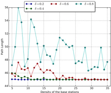
3.7 Path length Vs number of BS Vs Required accuracy . . . 49
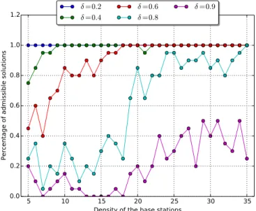
3.8 Percentage of admissible solutions . . . 50
3.9 Elevation angle gain determination (side view) . . . 51
3.10 Azimuth angle gain determination (top view) . . . 52
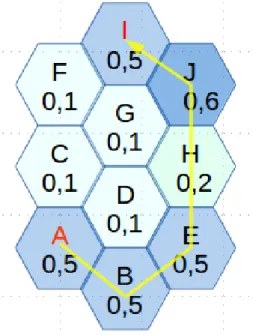
4.1 Example of a path from the origin A to the destination I where the shortest path with high packet delivery rate is (A, B, E, H, J, I) . . . 58
4.2 example of paths with the same cost . . . 59
4.3 Dynamics involved in the quadcopter . . . 61
4.4 Dynamic Model of quadrotor . . . 61
4.5 RPR with 10 noise nodes at h=60m . . . 67
4.6 RPR with 20 noise nodes at h=60m . . . 67
4.7 RPR with 30 noise nodes at h=60m . . . 68
4.8 RPR with 40 noise nodes at h=60m . . . 68
4.9 RPR with 50 noise nodes at h=60m . . . 69
4.10 noise nodes= 20 . . . 69
4.11 noise nodes= 50 . . . 70
4.12 set of near Optimal paths . . . 70
xvi List of figures
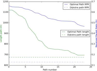
4.14 Length Vs RPR . . . 71
4.15 Path lengths with different number of noise nodes, h=60m . . . 72
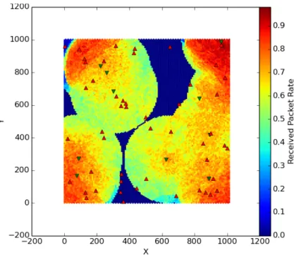
4.16 Received Packets Rate with different number of noise nodes, h=60m . . . . 73
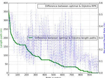
4.17 Difference between optimal and Dijkstra path length, nbr paths = 1000 . . 73
4.18 Difference between optimal and Dijkstra RPR, nbr paths = 1000 . . . 74
4.19 Received Packet Rate at different drone speeds, noise nodes = 50 . . . 74
4.20 Energy consumption at different drone speeds . . . 75
4.21 Simulation of Optimal path Vs Dijkstra shortest path tracking . . . 76
4.22 Area with obstacles of different shapes, properties and heights . . . 78
4.23 SINR maps at different altitudes in environment with obstacles . . . 78
4.24 Optimal path Vs Dijkstra shortest path tracking . . . 79
4.25 Optimal path Vs Dijkstra shortest path tracking . . . 80
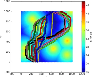
5.1 SINR map with the set of cells to be covered . . . 89
5.2 RPR maps with path lengths with 0 jamming nodes . . . 90
5.3 RPR maps with path lengths with 20 jamming nodes . . . 90
5.4 RPR maps with path lengths with 25 jamming nodes . . . 91
5.5 RPR maps with path lengths with 30 jamming nodes . . . 91
5.6 Received Packet Rate and Tour length fairness with different numbers of noise nodes . . . 92
5.7 Drone’s tracking under different number of noise nodes . . . 93
5.8 Received Packet Rate with different drones speeds . . . 94
5.9 Data gathered rate with different sensor power, noise nodes number=0 . . . 95
5.10 Drone speed and sensors power influence on data gathered rate . . . 95
6.1 Intruder search and report scenario . . . 98
6.2 Expected displacement radius of the intruder . . . 100
6.3 Reynolds Craig, Flocking rules . . . 101
6.4 UAVs swarm formation with different SNR separation parameters . . . 104
6.5 Intruder search and report scenario . . . 104
6.6 Intruder localization time efficiency comparison per number of drones and per methods . . . 106
6.7 Intruder Localization method comparison . . . 107
List of tables
2.1 UAV examples . . . 9
2.2 NATO Unmanned Aircraft Classification Guide [53] . . . 13
2.3 FAA USA Classification . . . 17
2.4 UAVs classification adapted from EUROUVS, Van Blyenburg, 2008 . . . . 18
3.1 Example of MCS Parameters in 802.11a/g [cis] . . . 46
3.2 Parameters configuration . . . 47
4.1 Phatom 3 Advanced drone characteristics . . . 62
4.2 Simulation parameters . . . 66
5.1 Simulation Parameters . . . 88
6.1 Simulation parameters . . . 105
Chapter 1
Introduction
1.1
A word about this manuscript
Recently, technological advances in micro controllers, sensors, and batteries have dramati-cally increased the small scale drones utility and versatility and yet, a new horizon is open for civilian uses. This began with observation and aerial mapping, disaster response including search and support to rescuers, sports events coverage and law enforcement. Although and despite the fact that market is almost nonexistent today, this is most likely in the civil field that drones are expected to play the largest role. Indeed, a forthcoming plans for drone commercial use have been recently announced by a number of companies around the world such, Amazon, Wallmart, DHL, and Zookal which are investing in mini drones development for variety of tasks, including freight and package delivery to consumers. The introduction of drones in civil applications raises new challenges to the government authorities in charge of flight security and air traffic management which have to balance safety and public concerns against the potential economic benefit.
By virtue of their small size, mini drones are difficult to be detected and to be tracked. In this frame, the European Parliament adopted a resolution on the use of drones, which requires Member States to implement various regulations to ensure the safety of the airspace and to ensure the privacy of citizens threatened by the use of these flying machines. Through this resolution, it is considered that regardless of their sizes, the question of identifying drones is essential, and emphasized the need to provide appropriate solutions in terms of locating and tracking. In other words, this new report aims to ensure the traceability of all Unmanned Aerial Vehicles (UAVs), but also operators and owners as sine qua non conditions for any use.
2 Introduction
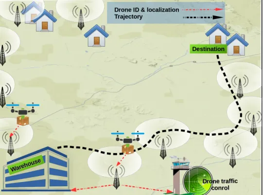
Motivated by the last considerations and by the recent prediction of the number of drones using the airspace in the near few years, we start, in this thesis, by exploring the tracking and the communications requirements between the drones and the government authorities in charge of the airspace management and the traffic control. Due to the limited range, communication between the small scale drones and the ground control operator is established through radio Line-of-Sight (LoS) links between the drones and the base stations deployed as parts of the ground wireless networks. We show that radio efficiency, particularly for drone identification and localization is critical to the large employment of drones in a noisy environment. One possible approach to deal with this consideration is a both offline path planning and online drone tracking.
Indeed, it is obvious that path planning is one of the most crucial tasks for mission definition and management of the aircraft and it will also be an important requirement for UAVs that has autonomous flight capabilities. Basically, an efficient off-line path planning could help to ensure a permanent localization and tracking of the drone. Moreover, the predetermined trajectory enables to avoid obstacles and eventual collisions with other drones, and also to optimize certain functionalities in certain environment. However, mission nature, battery capacity, drone characteristics and hovering capabilities strongly influence the path planning strategy. Thus, an online drone tracking is mandatory. To this end and in order to make this possible, one possible approach is the exploitation of the available ground wireless network coverage. This approach relies on a powerful interaction, or collaboration between the UAVs and the wireless network operators. Cooperation in such environment implies that the drone periodically send its identification, localization, speed and other information to the remote operators through the available wireless networks.
In parallel with regulation issues, we also focus on this thesis on mobile data gathering using UAVs. Mobile data gathering is a well-known technique, which uses a mobile collector (e.g. a communicating robot) that moves toward some sensors to collect the data. A better energy saving can thus be obtained for each sensor, compared to the conventional approach which requires the setting and the maintenance of end-to-end network paths between the sink and the sensors. This gain is higher when sensor nodes are deployed over a non-dense area. However, issues might arise when the sensors are spread over a very large area. Typical problems are related to the capacity of the mobile collector to reach all the sensors, either due to the terrain obstacles or because of its energy limitation. To address this challenge, recent research works investigated the use of UAV as Data Collectors in large scale Wireless Sensor Networks. Indeed, UAVs can quickly obtain an accurate data over large areas that are difficult or dangerous to access by traditional means. In addition the data can be collected when
1.2 Organization of the document 3
the need appears and usually at a lower cost, compared to other approaches. Unfortunately, battery limitation of nowadays civilian UAVs does not allow yet long-term missions of small UAVs. To overcome this limitation, we investigate in this thesis the use of multiple UAVs to gather data from sensors that are spread over large scale areas.
In addition, as part of this thesis we are also interested in applications related to the use of a group of drones, called swarm, in the context of the control and surveillance. More precisely, we focus on tracking applications where a fleet of drones is used to locate and to track the intruder in a sensitive area. Basically, our gaols are to determine the position of an intruder in a given area and to keep the fleet in a certain formation in order to avoid a collision between drones and to forward data situation to the controller side. The most important challenge is the coordination among the UAVs to share the space and the sensing resources for improving the perception of the environment. This challenge is due to sensing limitations, which could be due to limited sensor performance, limited detection, limited camera Field of View (FoV). These limitations are the main reason for multiplying the number of drones for such mission in order to increase the perception of the environment. However, increasing the number of drones in a limited space is not without problems and risks. Collision between the members of the swarm is the main problem. To this end, a behavioral approach based on the quality of signals between drones of the same swarm is explored.
1.2
Organization of the document
This manuscript describes five of our main contributions, which greatly facilitates the articu-lation of the chapters.
The chapter 2 is considered as introduction to the drone’s world. Parts of this chapter can be skipped or left as reading without loosing of continuity if the reader is already acquainted with drones generalities. However, the section related to the regulations is considered as the principal motivation of our contributions. After presenting a couple definitions and classifications of the Unmanned Aerial Vehicles we highlighted the issues related to the use of drones in the public airspace.
In Chapters 3 and 4, we describe the work carried out around the use of small drones for the transport of packages and parcels from the warehouses to the consumers. These chapters describe mainly the solutions adopted to allow the authorities responsible for the airspace management and the traffic control to track and to localize, in a reliable manner, the drones during their missions.
4 Introduction
The use of a swarm of UAVs for data gathering is presented in the chapter 5. Such kind of mission raises new considerations, in term of the number of UAVs required for a given mission, path planning of each UAV and of course many other objectives and constraints might be integrated to the path planning problem.
In chapter 6 we present a solution for a rational deployment of a swarm of drones to localize the intruder in a sensitive area.
Finally, Chapter 7 concludes the thesis and gives an outlook to the related future research directions.
Chapter 2
UAV Background
2.1
Introduction
The experience already gained with the drones and their potential technological development allow to assert that their role will increase significantly, both in the military and civil realm. Thus, drones occupy rightly and deservedly more and more important place in the aviation industry and defense, and there is a rise in power of experiments around the world.
In the military field, supplementing or replacing the piloted aircraft for some dangerous or very long missions, as well as for reconnaissance, intelligence and attacking. In the civilian domain, covering needs that traditional manned aircraft cannot always satisfy. Between the two, drones seem to provide a satisfactory response to a significant number of needs, but for many the use of drones doesn’t reach the desired level yet and their integration in many other applications is far from being satisfying. It’s clear that there is still a lot to do in the UAV domain.
Despite the fact the market is almost non-existent today, this is most likely in the civil field that drones are expected to play the largest role, and that due to their flexibility and versatility of their employment. The range of potential applications is almost unlimited. Drones are being the more credible to meet the need that is not covered by manned aircraft. This is the case of missions that can be considered dangerous, physically painful for the crew, or boring.
In fact, the civilian use perspectives of drones are promising and, mostly, seem still largely undervalued. As a first approach, by simple effect of imitation, civilians may observe the culture of drones among military, and its gradual extension outside the security and defense
6 UAV Background
use. Many civilian uses also remain to be discovered and, with them, the need for equipment and specialized software.
As in the military field, examples of potential applications can be divided into several broad categories, monitoring and observation, communications and transport. Indeed, UAVs are looked with increasing interest in civil and commercial applications and by the scientific research community and many applications can now be found especially with small-scale UAV development. These small-scale UAV are of particular interest due to their ease of deployment, high maneuverability, and low costs. Many actual UAV technologies can be adapted to the public sector applications, but some specific needs will require new UAV capabilities such as localization, tracking, sensing and avoiding, communication between UAVs etc.
In addition, with a continuing trend of miniaturization in electronics and other compo-nents, the drones can be made much smaller and much cheaper. However the capability of a single small UAV is limited. Coordination and cooperation between a group of small UAVs can create a system that is beyond the capability of one UAV. However, multi-UAV system cooperation has many challenges and one of the most prominent problems is communication.
If the civil and military potential application of a network of UAVs actually seems very high, it is not without raising some fundamental difficulties and issues which, if not resolved, severely penalize the optimal use of drones. The purpose of this chapter is to explain what the UAVs are, to present their considerable potential, but also to expose the problematic of their integration in the non-segregated airspace. This chapter is organized to reflect three main areas of drones.
First of all, we will define the unmanned aerial vehicle world. We will present the common definitions, classifications and applications adapted from both military and international civilian organisms. Secondly, this chapter attempts to describe unmanned aerial vehicles as single entities among a group or swarm. The cooperation and collaboration issues will be discussed. Finally, we will present the problem and challenges that hinder the widespread and the integration of the unmanned aerial vehicles in the non-segregated airspace.
2.2
Unmanned Aerial Vehicles
This section addresses all UAVs definitions being considered by the international organisms and States. It is intended to the scientific community and used to facilitate future discussions on UAV environments. It provides definitions of UAVs, a description of the operational
2.2 Unmanned Aerial Vehicles 7
environment and classifications. Several terms used in this document are defined below as a common point of reference.
2.2.1
Definitions
The word “drone” refers, commonly, to unmanned vehicles. However, this term is usually used to refer to Unmanned Aerial Vehicles (UAV). UAVs, also referred to as Unpiloted Aerial Vehicles and a Remotely Piloted Aircraft (RPA), are considered as one of the most important technologies in the field of aeronautics due to their variety of applications, flexibility, and high performance at low costs [58].
The most general definition which we can give to an UAV is an aircraft without a human pilot aboard. However, different definitions to UAVs exist regarding to the operational use and to the nature of the organisms using this technology.
According to the International Civil Aviation Organization (ICAO)1, UAVs are, basically, aircraft without a crew aboard that can be remotely operated or that follow a previously programmed mission [42]. On the other hand,the United States Department of Defense (DoD)2 Defines an Unmanned Aerial Vehicle as follows: "A powered, aerial vehicle that does not carry a human operator, uses aerodynamic forces to provide vehicle lift, can fly autonomously or be piloted remotely, can be expendable or recoverable, and can a carry lethal or non-lethal payload. Ballistic or semi ballistic vehicles, cruise missiles, and artillery projectiles are not considered unmanned aerial vehicles," [70]. Finally, in Europe, the EUROUVS3defines an Unmanned Aerial Vehicle or Remotely Operated Aircraft as "uninhabited, reusable or non-reusable, motorized aerial vehicles, which are remotely controlled, semi-autonomous, autonomous, or have a combination of these capabilities, that have a loitering capability and can carry various types of payloads, making them capable of performing specific tasks within the earth’s atmosphere, or beyond, for duration, which is related to their missions” [66].
1ICAO: International Civil Aviation Organization is a United Nations specialized agency, created in 1944
upon the signing of the Convention on International Civil Aviation (Chicago Convention). ICAO works with the Convention’s 191 Member States and global aviation organizations to develop international Standards and Recommended Practices which States reference when developing their legally enforceable national civil aviation regulations [ICA].
2DoD is the executive branch of the US government responsible for providing the necessary military forces
for the defense of the United States in time of war and peace.
3EUROUVS is a non-profit association registered with the chamber of Commerce in Den-Haag / Netherlands
and operates out of offices in Paris/France which represents manufacturers of unmanned vehicle systems (UVSs), and manufacturers of subsystems and critical components for UVSs and associated equipment.
8 UAV Background
In fact, unmanned aircraft systems (UAS) are a new component of the aviation system, one which the ICAO, States and the aerospace industry are working to understand, define and eventually integrate them into non-segregated airspace and at aerodromes [45]. Yet, UAV has become common vocabulary over the years. At present, UAS is defined as a system, whose components include the drone and all equipment, network and personnel necessary to control the unmanned aircraft [53].
Although the term of ’unmanned aircraft’ is the preferred appellation in the military environment, the term of ‘unmanned’ can cause confusion or uncertainty over the actual level of human control and responsibility, and has led the safety and the legal concerns being raised, especially concerning the employment of weapons and flights in non-segregated airspaces. These problems can be addressed in part by using terminology that describes the level of human control of such aircraft. Consequently, it may be appropriate to use the term Remotely Piloted Aircraft (RPA) to describe the unmanned aircraft, and Remotely Piloted Aircraft System (RPAS) to describe the entirety of that [17, 16].
However, due to the unclear responsibility for the autonomous and unmanned portion of the flight, the legal and liability issues, and in compliance with the terminology of the European roadmap, the ICAO recommends the use of the terms Remotely Piloted Aircraft (RPA) & Remotely Piloted Aircraft Systems (RPAS) instead of Unmanned Aircraft Vehicle (UAV) & Unmanned Aerial System (UAS) & drone.
2.2.2
Classifications
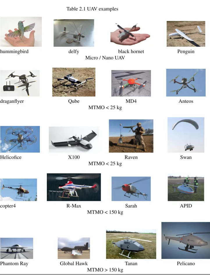
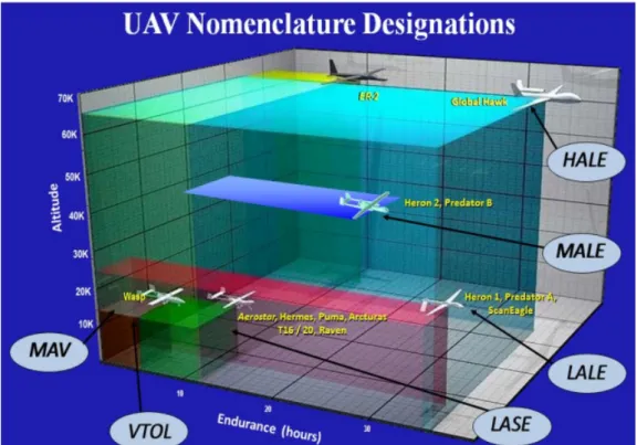
In the following we provide information on UAVs classification from different perspectives. UAVs classification system is required for many reasons, notably in the supporting and developing doctrine defense and concepts for nations [53] and for eventual integration into controlled airspace for a public use. There has been a great difficulty in reaching a consensus on which unmanned aircraft characteristics should be used as the primary factors in determining the structure of a classification system. The most common classification is based on the altitude criteria, weight and endurance, see Tab 2.1 and Fig 2.1.
2.2 Unmanned Aerial Vehicles 9
Table 2.1 UAV examples
hummingbird delfy black hornet Penguin
Micro / Nano UAV
draganflyer Qube MD4 Anteos
MTMO < 25 kg
Helicofice X100 Raven Swan
MTMO < 25 kg
copter4 R-Max Sarah APID
MTMO < 150 kg
Phantom Ray Global Hawk Tanan Pelicano
10 UAV Background
Fig. 2.1 DoD, UAV Nomenclature Designation
2.2.2.1 Military classification
The following classification system has been proposed and endorsed by the North Atlantic Treaty Organization NATO4to organize, train, equip, and standardize UAVs for optimum employment.
Unmanned aircraft systems can be divided into the following three categories and subcat-egories [44, 53] based on an aircraft maximum gross take-off weight and altitude. Catsubcat-egories start with weight classes, which are further divided on the basis of the operational altitude of the unmanned aircraft as indicated in Table 2.2.
Class I
This category of drones so called "contact UAVs" includes systems capable of providing military units who operate in contact with the adversary, a direct and immediate nearby intelligence, in open terrain or in urban areas. Principally destined to the troops or security forces, these vectors are commonly referred to mini drones and micro drones.
4NATO is an alliance of 28 member countries roughly bordering the North Atlantic Ocean: Canada, the
U.S., Turkey and most members of the European Union. NATO’s essential purpose is to safeguard the freedom and security of its members through political and military means [Amadeo, NAT]
2.2 Unmanned Aerial Vehicles 11
This class includes UAV of weight less than 150 kg. These are mostly hand-launched and portable systems employed at the small unit level to provide reconnaissance and surveillance information. This class operates within the line of sight (LoS) at altitude less than 5.000 feet above ground level (AGL) and has limited range up to 50 km. In accordance with weight, this class is further divided into three subcategories, small, mini and micro UAV:
• The first category which gathers UAVs with weight less than 150 kg and greater to 20 kg within operational range up to 50 km, such Hermes 90 and Luna. The later uses a 3D digital terrain map model and constantly monitors the terrain and known obstacles in its flight path, to avoid a collision.
• The second subcategory, named ’mini drone’ includes drone with weight between 2 and 20 kg such as DH3, Raven, Scan Eagle, T-Hawk and others. Mini drone systems are the smallest UAVs used by lowest tactical echelons and special operation forces to gather intelligence "over the hill" and "around the corner".
• The third subcategory includes micro-drones with weight less than 2 kg, so called because of their size, which typically enables military versions of these aircraft to be transported within individual soldiers’ backpacks. These aircraft tend to operate at very low altitudes, with size limitations on battery capacity offering little autonomy and payload capacity leading to short flight times (5–30 min). Most of these systems developed by industry, such as the Lockheed Sanders “MicroSTAR”, the AeroViron-ment “MicroBat” and “Black Widow”, and the Lutronix “Kolibri”, are designed with small color video system payloads.
Class II
Known as "tactic UAVs", the drones of this class are primarily destined for intelligence missions and target acquisition over a large limited area. They are essentially characterized by the use of the LOS link of a practical range of 100 to 200 kilometres depending on the flying altitude. Possessed by many countries, tactical UAVs are available in a large number of different models suitable for air-land and air-sea environments. They usually privilege the launch and recovery modes that do not require fixed infrastructure.
This class includes drones with weight between 150 kg and 600 kg such as Sperewe, Iview 250, Hermes 450 and Watchkeeper. It covers generally medium-sized unmanned aircraft, often catapult-launched, mobile systems that usually support brigade level and tactical formation in matters of intelligence and surveillance, target acquisition and reconnaissance.
12 UAV Background
These unmanned aircraft are built to operate with the forward troops, operating at lower altitudes of up to 10,000 feet AGL with a medium range of 125–200 km. The mission endurance is relatively short, around 7–20 hours.
Class III
It characterizes several systems of drones with great endurance using satellite links beyond the line of sight (BLOS) and generally take off from fixed airport infrastructure. This includes typically the largest and most complex unmanned aircraft with weight more than 600 kg, operating at high altitude with the greatest range and endurance. Unlike the other classes, a prepared surface for take off and landing is required. They perform specialized missions such vast area surveillance and penetrating attacks. Payloads may include sensor with EO/IR, radars, lasers, communications relay and weapons. These include strategic high altitude long endurance platforms (HALE) and medium altitude extended range systems (MALE).
Since MALE drones are operating at lower altitudes, they transmit more detailed imagery of targets. At this cruising altitude, MALE platforms can evade most adverse weather conditions. HALE are the largest and most complex of the UAS. It might fly at altitudes of 20,000 m or more on missions that extend thousands of kilometers. Some HALE aircraft have flight duration over 30 h, and have set records for altitude and flight duration. The High Altitude and Long Endurance mission profile was never meant to be used with manned platform, but is perfectly suited for unmanned systems.
It is inevitable that there will be some UAV types that do not fit accurately within a single class or sub-class. For example, an UAV weighing 15 kg that operated up to 8.000 feet AGL would still be considered a Class I UAS.
2.2 Unmanned Aerial V ehicles 13
Table 2.2 NATO Unmanned Aircraft Classification Guide [53] Class
Weight, w(kg)
Category Weight, w(kg)
Normal employment Normal operating
Altitude, h(ft) AGL Normal Mission Radius (km) Example Platform Class I w<150 kg Micro w<2kg
Tactical Platoon, sec-tion, Individual (single operator)
h ≤ 200 5km (LOS) Black Widow
Mini
2 ≤ w ≤20 kg
Tactical Sub-Unit (man-ual launch)
h ≤ 3.000 25km (LOS) ScanEagle, Skylark,
Raven, DH3, Aladin, Strix
Small w > 20 kg
Tactical Unit (employs launch system)
h ≤ 5.000 50km (LOS) Luna, Hermes 90
Class II
150≤w≤600kg
Tactical Tactical Formation h ≤ 10.000 200km (LOS) Sperwer, Iview 250,
Hermes 450, Aerostar, Watchkeeper, Ranger
Class III
w>600kg
MALE Operational / Theater h ≤ 45.000 Unlimited (BLOS) Predator A, Predator B,
Heron, Heron TP, Her-mes 900
HALE Strategic / National h ≤ 65.000 Unlimited (BLOS) Global Hawk
14 UAV Background
2.2.2.2 Civilian classification
The classification of drones for civil and scientific uses has generally followed existing military descriptions and varies according to the context and countries. This classification can be done according to several criteria such as physical size, weight, endurance, altitude, engine type, performance, etc. [70].
ICAO classification
ICAO Classifies unmanned aircraft into two types under the Circular number 328 AN/190 [40]:
• Autonomous aircraft: autonomous aircraft is an unmanned aircraft that does not allow pilot intervention in the management of the flight [45]. Currently considered unsuitable for regulation due to legal and liability issues.
• Remotely piloted aircraft: An aircraft where the flying pilot is not on board the aircraft. This kind of UAV is subject to civil regulation under ICAO and under the relevant national aviation authority.
United States classification
For many years, classification of UAVs in the United States of America has been closely associated with the frame related to the type and the nature of the mission without taking into account the requirements needed to operate in the National Air Space. Recognizing that the drones community might be better served by specific rules, the FAA5is initially proposing to amend its regulations to adopt specific rules for the integration of drones in the national airspace. These changes will concern the classification of drones, registration, pilots certification and operation regulations.
The named classification concerns systems developed by the DoD and other organisms and attempts to organize the types and characteristics of over 200 different drones. Table 2.3 provides a different set of descriptors that uses some FAA classifications to further define the growing variety of smaller UAS.
• ULTRALIGHT: includes drones of weight fewer than 254 lbs (115.2 kg), excluding floats and safety devices which are intended for deployment in a potentially catastrophic
5 FAA: The Federal Aviation Administration is a government agency responsible for regulating and
2.2 Unmanned Aerial Vehicles 15
situation. They can be fixed-wing as well as rotary. Ultralight size UAS category includes among other the Inceptor, Mako, Cobra, Bat 4 and Golden Eye. A majority of these vehicles are in the 100 to 150 lbs range. Major missions include ISR (Intelligence Surveillance Reconnaissance)6, but also packages delivery services as well.
• LIGHT SPORT AIRCRAFT: this class includes drones with maximum gross takeoff weight 1320 lbs such seaplane models. There is a limited number of UAVs in this size and weight range.
• SMALL AIRCRAFT: these are systems over 1320 lbs, operating below Class A airspace (18kft). Examples of these types of aircraft are the Hunter, Predator and Reaper series. This class of drones also provides a fast and powerful combat attack vehicle that is relatively small when compared to a manned fighter.
• MEDIUM AIRCRAFT (12,500 lbs to 41,000 lbs): An example of this aircraft is the Global Hawk that is configured to carry a large payload of munitions. Such kinds of drones moves into the strategic range of long-distance ISR missions.
European Classification
In Europe, UAVs classification is still in the process and not achieved yet. The long march towards a coherent European set of regulations is being coordinated by EUROCONTROL, which is working closely with the national European aviation authorities through EUROCAE (European Organisation for Civilian Aircraft Equipment), EDA (European Defence Agency) and EASA (European Aviation Safety Agency). Meanwhile, the civil aviation authorities of the member States of the European Union (EU) has adopted different classifications. Generally, UAVs are classified into two categories regarding to their Maximum Take Off Mass (MTOM), UAV with MTOM of more than 150 kg and UAV with MTOM less than 150 kg. Other subcategories might exist.
In addition, several different groups have proposed creation of reference standards for the international UAV community. The European Association of Unmanned Vehicles Systems (EUROUVS) has drawn up a classification of UAV systems based on such parameters as flight altitude, endurance, speed, maximum take off weight (MTOW), size, and so forth. EUROUVS did not create this classification for certification purposes, but rather with the
6ISR: ISR is the coordinated and integrated acquisition, processing and provision of timely, accurate,
16 UAV Background
main purpose of compiling a universal catalog of UAVs categories as well as their associated acronyms.
The table 2.4 is adapted from EuroUVS classification. It identifies three main UAV categories:
• Nano/Micro/Mini UAVs: comprises the category of the smallest platforms that also fly at lower altitudes, under 300 meters. We can find in this class any UAV under 30 kg flying at altitudes between 150 and 300 m with endurance about 2 hours. This category of UAVs can operate in urban or even inside buildings, carrying listening and recording devices. This includes the Black widow, Microbat, Fancopter and Microstar.
• Tactical UAVs: this category includes heavier platforms flying at higher altitude from 3000 to 8000 meters, which mostly support military applications. Referring to Table 2.4, tactical UAVs can be divided in four subcategories: close range, short range, low altitude long endurance and medium altitude long endurance.
• Strategic UAVs: at higher altitudes, UAVs tend to be heavier platforms. Thus, they could carry larger payload and reach greater distances, where does the HALE appel-lation came from. The mass is varying from 2500 kg to 12.000 kg and flight altitude is about 20.000 meters. Such kind of UAVs are considered as strategic drones. The Global Hawk, with 35 hours of endurance is probably the best-known HALE UAV.
2.2 Unmanned Aerial V ehicles 17
Table 2.3 FAA USA Classification
UAS Weight
(pounds)
Overall size (feet)
Mission Altitude (feet above the surface)) Mission speed (miles/hour) Mission Radius (Miles) Mission Endurance (Hours) Nano < 1 < 1 <400 <25 <1 <1 Micro 1 to 4,5 < 3 < 3.000 10 to 25 1 to 5 1 Small UAS 4,5 to 55 <10 <10.000 50 to 75 5 to 25 1 to 4
Ultra light aircraft 55 to 255 <30 <15.000 75 to 150 25 to 75 4 to 6
Light Sport Aircraft 255 to 1320 <45 <18.000 75 to 150 50 to 100 6 to 12
Small Aircraft 1.320 to 12.500 <60 <25.000 100 to 200 100 to 200 24 to 36
-18
U
A
V
Background
Table 2.4 UAVs classification adapted from EUROUVS, Van Blyenburg, 2008
Category Acronym Range
(Km) Flight Altitude (m) Endurance (h) Maximum Take Off Weight (kg) Nano/Micro/Mini Nano n <1 100 <1 <0.025 Micro u <10 250 1 <5 Mini mini <10 150-300 <2 <30
Tactical UAVs Close Range CR 10-30 3000 2-4 150
Short Range SR 30-70 3000 3-6 200
Low Altitude Long Endurance LALE >500 3000 >24 <30
Medium Altitude Long Endurance MALE >500 14000 24-48 1500
Strategic UAVs High Altitude Long Endurance HALE >2000 20000 24-48 4500-12000
-2.2 Unmanned Aerial Vehicles 19
2.2.3
UAVs Types
As we mentioned before, UAVs come in many shapes and sizes. They are currently divided on tow categories, fixed wing and rotary wing, see Fig 2.2. Each of these have their own unique pros and cons.
(a) Fixed-wing drone (b) Rotary wing drone
Fig. 2.2 UAV types
2.2.3.1 Fixed-wing UAV
Fixed-wing UAV consists of a rigid wing which makes flight possible by generating lift caused by the UAV speed. The airspeed is generated by an internal combustion engine or electric motor.
• Pros: The major advantages of a fixed-wing UAV consist of:
– a simple structure which needs a less complicated maintenance and repair process; – an efficient aerodynamics that provides the advantage of longer flight duration at
higher speeds and at a lower cost; – a larger survey area per flight; – a gliding capabilities with no power;
• cons: The fixed-wing UAVs presents some inconvenient while they: – need a runway or a launcher to takeoff and for landing;
– require air moving over their wings to generate lift which means they cannot stay stationary and therefore they are not suitable for stationary applications like inspection work.
20 UAV Background
2.2.3.2 Rotary Wing UAV
The rotary wing UAVs are also known as Vertical Take-Off Landing (VTOL) vehicles. • Pros: this type of drone:
– does not require runways to take off or for landing;
– is able to fly in every direction, horizontally and vertically;
– can hover in a fixed position. This makes it the perfect tool for detailed inspection work or surveying hard-to-reach areas such as ravines, pipelines, bridges, power lines and rail tracks ;
– can perform hard movements which require manoeuvring around tight spaces; – requires a minimum launching time;
– does not need enough space for a landing.
• Cons: Rotary wing aircraft involves greater mechanical complexity which is translated generally into:
– lower speeds;
– shorter flight ranges; – vibrations.
2.2.4
Applications
Most drones are or can be equipped with cheaper and sophisticated technologies such as cameras and sensors that can record and transmit data, image and video to the ground control station. Thus, these new capabilities of UAVs offer to revolutionize numerous fields and applications. Before discussing the rest of this thesis, it is important to sweep the most exhaustive possible missions that are potentially attributable to drones.
1. Search and Rescue: Ideal for quickly cover large areas of territory, the drone is a valuable tool in the search for peoples who are in distress or in imminent danger, and this in different environments, typically determined by the type of terrain the search is conducted over. These include mountain and desert rescue, urban search and rescue in cities, combat search and rescue on the battlefield and air-sea rescue over water. The use of small-scale unmanned aerial vehicles for such operations is
2.2 Unmanned Aerial Vehicles 21
becoming a logical choice for many countries. The Royal Canadian Mounted Police in the province of Saskatchewan announced on may 2013 that they successfully used the small Draganflyer X4-ES helicopter drones to locate and treat an injured man whose car had flipped over in a remote, wooded area in near-freezing temperatures [5]. According to this source, it was the first time that a life may have been saved with the use of a small Unmanned Aerial System.
2. Remote Sensing: The capabilities found in UAVs offer to revolutionize natural re-sources management, remote sensing, and numerous other fields. Envisioned appli-cations include situation awareness, patrol borders, unexploded ordnance detection, forest fires warning, vegetation mapping etc.:
• Situation awareness: Recent earthquakes have also seen UAV deployment for post-disaster imagery collection in L’Aquila/Italy in 2009 and Haiti in 2010. Quadcopter UAVs furnished with a camera evaluated the application of UAVs for fire service response [9]. After the Haiti earthquake, an Elbit Skylark UAV was used to assess orphanage damage in remote mountains near Port au Prince [9]. The UAV relayed real time imagery that indicated that the orphanage’s critical infrastructure was intact, allowing rescue efforts to concentrate on other areas of need, rather than having a critical time required to travel to the remote orphanages.
In the same frame and in March of 2011, Japan endured a devastating earthquake and subsequent tsunami. Fukushima Daiichi nuclear facility was significantly damaged and consequently began to emit radiation. This hazard complicated repair and traditional reconnaissance efforts as humans were advised to avoid the area. To remedy the imagery collection issue, two remotely operated UAVs equipped with telescopic infrared sensors and outfitted with special radiation sensors were deployed to the area [8].
• Unexploded ordnance detection: Statistics showed that there are over 100 mil-lion undetected terrestrial landmines scattered over the world. Many people are injured every day of which 90% of the victims are civilians [32]. The overall political and legal framework covered by several treaties and conventions em-phasize in eliminating explosive devices including landmines and unexploded ordnance around the world, therefore a global effort in a multidisciplinary manner is required to address this issue. This ranges from improving quality of the information on the threat, developing new survey and clearance procedures and
22 UAV Background
deploying better equipment including improved sensors. Therefore, the use of antennas mounted on UAVs allows performing a wide area scanning, a contactless remote sensing in high-risk area as well as rapid and mobile surveying.
• Forest fires warning: Based on recent demonstration missions, the US Forest Service envisions using LASE and MALE Unmanned Aircraft for fire detection and active fire monitoring missions [70]. VTOL aircraft are particularly appealing in wildfire and disaster response situations where access to improved surface runways is seldom guaranteed.
• Vegetation mapping: A vegetation map illustrates the geographical spread of a plant community. It provides extremely important basic information for envi-ronmental planning. In [36], research was conducted to present a more precise mapping of vegetation using UAV as a new method of creating vegetation maps. To do so, an aerial photography using UAV was conducted in the Niida River Estuary (Fukushima Prefecture, Japan) in August 2013. The authors proceeded by comparing vegetation maps created by aerial photographs taken by an UAV and an aircraft (manned flights). According to this author, the aerial photographs taken by the UAV have clearly discriminated each plant community at the 1/50 scale. Moreover, he specified that they clearly discriminate the shape of a plant at the 1/10 scale. As a result, the authors conclude that vegetation surveys using UAV are efficient and capable of a highly precise community distribution where field reconnaissance is difficult.
• Oil, gas and mineral exploration : UAVs can be used to perform geophysical sur-veys, in particular geomagnetic surveys to calculate the nature of the underlying magnetic rock structure [71]. The production and the exploration of oil and gas entail the monitoring of the integrity of oil and gas pipelines and related installa-tions. For above-ground pipelines, the monitoring activity could be performed using small uavs.
3. Extending network connectivity:
The success of any communication mission between several geographically dispersed nodes is based on a constant flow of communication allowing the exchange and the update of information continuously. However, this requirement is not always satisfied because of the limited range of wireless radio communications often obscured by obstacles, particularly when remote nodes operate in urban, mountainous or rugged environments. The problem becomes worse when the rate of wireless links increases.
2.3 Challenges 23
One solution is to use relays to relay signals from one location to one or more other locations, thereby maintaining broadband connections, facilitating communications and extending the range between nodes. UAVs can significantly extend the reach of telecommunication links when employed as relays, even in the presence of physical obstacles [24, 62, 60].
4. Transporting freight: Experiments to carry small cargo are on going in many countries in Europe, the USA and in Australia. Companies such as Amazon, Facebook, DHL, Google and others are investing in drone development for a variety of tasks, including delivery of retail goods to consumers and creation of sky-based computer networks [21, 51].
5. Indoor applications: Another operational environment, indoor of structures and build-ings, is rapidly emerging as a key application domain. If drones have already been sharpened the most fertile imaginations for outdoor use in different sectors, indoor uses are still marginal. Micro UAVs offer the advantages of enhanced maneuverability in cluttered spaces and to date just few deployments have been done indoor buildings. In 2011, Parrot AR drones were used to inspect the Christchurch Cathedral, New Zealand, that had sustained significant damage after an earthquake strike and made it too dangerous for humans to get in. In a similar case, in Mirandola, Italy, after the 2012 earthquake, a team of flying and ground-based robots was successfully deployed to inspect the damage caused to the historical cathedral and to produce 3D map recon-struction to report on structural damage to ceilings, arches and aisles [23]. The recent one, a French innovation signed by Hardis Group is related to the use of micro UAV to automate inventory in warehouses and which aims to put on the market in the near few years[33]. With embedded system drone, logisticians can automate inventory in warehouses, identify and correct storage errors. Because of their size and their ability to perform stationary and translation flights, their use in the warehouse opens up new prospects for logistics.
2.3
Challenges
The use of drone technology can revolutionize the way states and authorities acquire and manage spatial data as well as the manner in which the industrial, researcher and other devel-opment partners design, implement, and monitor their projects by making these processes more accurate and cost effective.
24 UAV Background
The emergence of small and affordable drone technology and their eventual large field applications promises a widespread of them use. In fact, with their small size and portable versions, drones can produce accuracy results equivalent or better in many cases than the conventional manned aircraft and offers cost savings and greater flexibility. For example, UAVs allow the placement of sensors anywhere in 3D space and subsequently, add new dimensions to baseline data gathering and alternative assessments of the situation and the environment without placing people in a hazardous environment.
In the last years, the Unmanned Aerial Vehicles have been the subject of much discus-sion surrounding the military uses in conflicts, crises and war but also, and with a higher degree, around them integration in the global non-segregated airspace, and this for civil and commercial use.
Although the use of drones is expanding and their prospect seems promising, the level of their integration is far from being efficient. Actually, many problems hinder the integration of the UAVs into a global non-segregated airspace and need to be solved. The most important are related to the standards, norms and regulation relevant to airworthiness and certifications. Additionally, other critical technical issues exist, such sense & avoid capabilities, transpon-ders, secure and powerful communications, reliable emergency procedures, safety systems and above all public acceptance [59].
The optimal use of drones and the generalization of their employment raise, however, a number of difficulties that need to be resolved over time. These difficulties are not always at the same level, depending on the framework of use, military or civilian. Essentially, these difficulties and changes are of two types, legislative and technical.
This section examines the actual problems that face the vulgarization of drones and their integration in the non-segregated airspace.
2.3.1
Regulations
Drones technology is a rapidly progressing industry and unlike many other new technologies, the legal and regulatory framework crawl behind. At present, there are no common interna-tional certification or standards and the actual legal sphere lies between the well-regulated conventional manned aircraft under the legislation of civil aviation authorities and the less rigorous rules related to small size drones destined for hobbyists recreation. Thus, there is currently little regulatory measures for accommodating UAVs within the existing framework of rules governing routine flights in non-segregated airspace.
2.3 Challenges 25
In Europe as well as in US, the airspace usage issue seems to stand out as the prime impediment to progress and development of the public UAV market. Thus, despite its expansion, an adequate regulatory framework on a global level does not exist yet. Meanwhile, UAVs remain used but under a fragmented regulatory framework and under different rules.
In order to guarantee a reliable and safe integration of UAVs in non-segregated airspace, there is a need for a common rule governing UAVs design and operations across the countries and a mutually agreed legislation, protocols, and technologies. Such Regulations will rely upon agreed standards of airworthiness certification. Afterwards, delivering of airworthiness certification in turn will be impossible for UAVs operating in the same airspace as other aircraft without a reliable, foolproof, sense and avoid capabilities that guarantees the safety of the overflown population [8].
Some countries have already adopted legislation and relevant bylaws to enable the operation of small UAV’s on their territory. Canada, Australia and Brazil voted their first regulations for UAV’s between 2007 and 2011, the UK in 2011 and France in 2012. These regulations are not considered like fixed. They will change along with the progress and development of UAV industry [6]. However, although many states endeavour to address the issue at local level the legislation is relatively limited.
2.3.1.1 In Europe
In Europe, the European Aviation Safety Agency (EASA)7is responsible for civilian aircraft with weight more than 150 kg. Cause there are no rules regulating integration unmanned aircraft in non-segregated space, UAVs with weight superior than 150 kg are prohibited in Europe. Regulations that govern this class of drones are planned for the next near few years. In addition, for eventual airspace use, the UAV must fulfil four basic requirements [19, 25]:
• the aircraft must be approved (Type Certificate);
• all components of the unmanned aircraft system including ground station must be certified;
• pilots must be licensed;
• payload operators must be licensed.
7EASA: European Aviation Safety Agency is the European Union Authority in aviation safety. The main
activities of the organization include the strategy and safety management, the certification of aviation products and the oversight of approved organizations and EU Member States
26 UAV Background
EASA is following a new regulatory approach called “Concept of Operation for drones” based on input from users and UAVs manufacturers. This approach includes new standards and cover safety, security, privacy, data protection, insurance and liability issues [27]. This concept has been developed to achieve two main objectives. First, to integrate drones into the existing aviation system in safe and proportionate way, and second, to promote European drone industry, particularly, the small and medium enterprises and to create new employment. Taking in consideration the large range of types of UAVs and their applications, the concept approach is proposed to establish three categories of operations:
1. Open category: Includes drone operations with very low risk. No aviation authorities authorization, no airworthiness approval and no licenses are required for operators even for commercial operations. However the drone must be flown under direct visual line of sight (500m), at an altitude not exceeding 150m and to remain outside and far off specified reserved areas (airports, restricted zones...). It is envisaged a maximum mass limit of drones operating in populated area.
2. Specific category: Covers operations where certain risk needs to be mitigated and reduced by additional limitations or higher capabilities of the UAS. This said, a safety risk assessment is required by the national aviation authority to deliver an Operation Authorization with specific limitations. In some cases, the issuance of the operation authorization might require a certification of the drone or of a specific function. 3. Certified category: When drone operation risk rises to a level comparable to normal
manned aircraft, the operation is positioned in the certified category, and therefore, specific certificates to drones would be issued as well as certificates for piloted aircraft. The definition of the lines of demarcation between specific and certified categories is still open at this stage and meanwhile, the EASA will continue to accept applications for drones of a MTOM (Max Take Off Mass) above 150 kg and those which are in accordance with EASA sphere activities and ability (aircraft not specifically designed or modified for research, experimental or scientific purposes, and not likely to be produced in very limited numbers [54]).
Within Europe, Light UAVs are characterized by having a MTOM of less than 150 kg. UAVs with MTOM above 150 kg are assessed by EASA and those less than 150 kg by EuroUSC8, an independent light UAV approval specialist, authorized to assess the
8EuroUSC is a specialist accreditation body working with specific field of civil aviation for UAV. It is a
qualified entity for assessing manufacturers, operators and flight training school involved in light UAV having a MTOM of less than 150 kg
2.3 Challenges 27
airworthiness of light UAV having MOTM of less than 150 kg. This includes the functional assessment of embedded software which is large part of most modern UAV safety systems.
The EuroUSC developed and introduced two certificates type for flight:
• BNUC: Basic National UAS Certificate for drones having MTOM between 20 kg and 150 kg;
• BNUC-S: for small UAV having MOTM of less than 20 kg.
Progress in the Single European Sky (SESAR) project, running in parallel, also has relevance for the integration of UAVs into controlled airspace by 2020.
In the broadest sense, experimental or amateur, military and civil drone below 150 Kg as well as model aircraft that generally recognized as intended for recreational purpose only, fall outside the provision of ICAO and EASA, being exclusively the subject of relevant national regulations. The National Aviation Authority of each of the 28 European Union (EU) Member States is responsible in its country for rulemaking, certification & operational approval of civil UAV with a MTOM less than 150 kg and for the drone operators. It is imperative that the operator crew and the UAV they operate are of the appropriate standard to avoid accident. Current regulation on insurance requirements for air carriers and operators does not require insurance for model aircraft of less than 20 kg.
2.3.1.2 In the United States of America
In the United States of America, the FAA is responsible for establishing guidelines, plans and rules for the safe and efficient use of the United State navigable airspace. These charges and liabilities also include the integration of drones into the United State airspace in a manner that supports and maintains the ability to secure the airspace and that addresses privacy concerns. Furthermore and when it’s appropriate, the FAA will harmonize with the International Civil Aviation Organization (ICAO) for the mutual development of civil aviation and the integration of the drones in the non-segregated airspace.
Introducing drones into the USA airspace is challenging for both the FAA and aviation community, because the United States has the busiest and the most complex airspace in the world. With the proliferation of drones, it will be more than essential to open the controlled airspace to mix usage for both manned and unmanned aircraft. The FAA has stated that for unmanned aircraft to fly regularly in the controlled airspace, those drones must meet the same FAA airworthiness standards as manned aircraft.
28 UAV Background
For the integration of small drones (under 25 kg) in the national airspace, the FAA has proposed a framework of regulations that would allow routine use of this class of drones in the aviation system, while maintaining flexibility to accommodate future technological innovations. The proposal offers safety rules and an incremental approach to save this integration. In general, UAV must remain within VLOS only and must remain close enough to the operator to be capable of seeing the UAV without any device other than corrective lenses. The operator would be required to pass an aeronautical knowledge test and obtain an unmanned aircraft operator’s certificate. In addition, no person may act as an operator or visual observer for more than one UAV in the same time [7, 30].
Under the proposed rules, the pilot of a small UAV would be considered "Operator". This means that he would have to be at least 17 years old, and should pass an initial aeronautical knowledge test at an FAA-approved knowledge testing center and a recurrent aeronautical knowledge test every 24 months.
The new rule also proposes operating limitations designed to minimize risks to other aircraft and people and property on the ground:
• The operator must avoid manned aircraft and in case of collision risk, the drone operator must be the first to manoeuvre away.
• The operator must change the direction of the flight when continuing would pose a danger to other aircraft, people or property.
• The operator must assess meteorological conditions, airspace and area restrictions. • The flight over people is prohibited, except over those involved with the flight. • The flight should not exceed an altitude of 500 feet and speed of 100 mph.
• The operators must stay out of airport flight paths and restricted areas, and obey to any temporary flight restrictions.
The proposed rules also include discussion of the possibility of an additional integration for micro drones weighing less than 4.4 pounds. The FAA is asking the public to comment on this proposal to determine and develop the final rules.
For more details, readers are encouraged to read (UAS Overview and the Proposed Small UAS Rule [30]).
2.3 Challenges 29
2.3.2
Energy
UAVs come in a variety of sizes and shapes and deployed for diverse purposes. The rotary wing drones have generated great interest in industrial and scientific circle. They have exclusive capabilities like hovering, vertical take-off and landing (VTOL), limited launching space and good manoeuvring. However, this class of UAVs is a power constrained as the UAVs operate with restricted battery power. Subsequently, Ad hoc networks based on UAV are in them turn power constrained too. The energy saving is a very important issue.
With regard to communication, there is also an amount of energy wasted in states that are useless from the application point of view, such as data retransmission when reception problems occur at the received side. Consequently, UAVs have to manage their transmission and their movements to preserve and maintain the battery life [18].
Since batteries is a limiting factor in UAV usefulness and design, it is possible the world will see better batteries quite soon. Several innovations in the field of battery design are showing great promise in improving batteries.
2.3.3
Reliability
Regardless of size, the responsibility to fly safely applies equally to be manned and unmanned aircraft operations. Most jurisdictions that regulate manned aircraft flight in their airspace also restrict some aspect of unmanned aircraft use. Motivations behind these restrictions include safety of people on the ground and above as well as security against the misuse of UAS.
Thus, the drones must always meet airworthiness criteria and respect of air traffic rules, analogous to those airplanes. This requires them to benefit from a certain level of technical reliability and resistance to crash (to ensure security on the ground) but also of a satisfactory reliability of the behavioral point of view (to ensure the safety of other aircraft in flight). Reliability must be exercised with regard to proximity detection, steering control, data exchange with ground control, as well as the management capacity of degraded situations. This is a crucial issue for drones which, a priori, does not currently meet these constraints. The resolution of these difficulties could, of course, lead to the creation of a certification of drones by the competent authorities, as for all other aircraft. This would provide some guarantees in the desired levels of reliability.