HAL Id: hal-00299407
https://hal.archives-ouvertes.fr/hal-00299407
Submitted on 24 Jan 2007
HAL is a multi-disciplinary open access
archive for the deposit and dissemination of
sci-entific research documents, whether they are
pub-lished or not. The documents may come from
teaching and research institutions in France or
abroad, or from public or private research centers.
L’archive ouverte pluridisciplinaire HAL, est
destinée au dépôt et à la diffusion de documents
scientifiques de niveau recherche, publiés ou non,
émanant des établissements d’enseignement et de
recherche français ou étrangers, des laboratoires
publics ou privés.
avalanche on Leyte Island, Philippines: a catastrophic
landslide in tropical mountain terrain
S. G. Evans, R. H. Guthrie, N. J. Roberts, N. F. Bishop
To cite this version:
S. G. Evans, R. H. Guthrie, N. J. Roberts, N. F. Bishop. The disastrous 17 February 2006
rockslide-debris avalanche on Leyte Island, Philippines: a catastrophic landslide in tropical mountain terrain.
Natural Hazards and Earth System Science, Copernicus Publications on behalf of the European
Geo-sciences Union, 2007, 7 (1), pp.89-101. �hal-00299407�
Nat. Hazards Earth Syst. Sci., 7, 89–101, 2007 www.nat-hazards-earth-syst-sci.net/7/89/2007/ © Author(s) 2007. This work is licensed under a Creative Commons License.
Natural Hazards
and Earth
System Sciences
The disastrous 17 February 2006 rockslide-debris avalanche on
Leyte Island, Philippines: a catastrophic landslide in tropical
mountain terrain
S. G. Evans, R. H. Guthrie, N. J. Roberts, and N. F. Bishop
Landslide Research Program, Department of Earth Sciences, University of Waterloo, Waterloo, Ontario, N2L 3G1, Canada Received: 31 July 2006 – Revised: 8 January 2007 – Accepted: 8 January 2007 – Published: 24 January 2007
Abstract. In February 2006, a disastrous rockslide-debris
avalanche occurred in tropical mountain terrain, on Leyte Is-land, Central Philippines. Over 1100 people perished when the village of Guinsaugon was overwhelmed directly in the path of the landslide. The landslide was initiated by the failure of a 450 m high rock slope within the damage zone of the Philippine Fault where the rock mass consisted of sheared and brecciated volcanic, sedimentary and volcani-clastic rocks. Tectonic weakening of the failed rock mass had resulted from active strike-slip movements along the Philippine Fault which have been estimated by other work-ers at 2.5 cm/year. The landslide involved a total volume of 15 Mm3, including significant entrainment from its path, and ran out a horizontal distance of 3800 m over a vertical dis-tance of 810 m, equivalent to a fahrb¨oschung of 12◦. Run-out
distance was enhanced by friction reduction due to undrained loading when the debris encountered flooded paddy fields in the valley bottom at a path distance of 2600 m. A simulation of the event using the dynamic analysis model DAN indi-cated a mean velocity of 35 m/s and demonstrated the con-tribution of the paddy field effect to total run-out distance. There was no direct trigger for the landslide but the land-slide did follow a period of very heavy rainfall with a lag time of four days. The rockslide-debris avalanche is one of several disastrous landslides to have occurred in the Philip-pines in the last twenty years. In terms of loss of life, the Guinsaugon event is the most devastating single-event land-slide to have occurred worldwide since the Casita Volcano rock avalanche-debris flow which was triggered by Hurri-cane Mitch in Nicaragua in 1998.
Correspondence to: S. G. Evans
(sgevans@sciborg.uwaterloo.ca)
1 Introduction
On 17 February 2006 a disastrous landslide occurred in Southern Leyte Province, Leyte Island, the Philippines (Lag-may et al., 2006; Fig. 1). It originated on a steep 450 m high, heavily-forested rockslope and swept down into the densely-populated Himbungao River valley. The landslide overwhelmed the village of Guinsaugon resulting in the loss of over 1100 people, including 250 schoolchildren who were attending morning classes at the Guinsaugon School.
The landslide is one of the largest to have occurred in tropical mountain terrain in recent years. The event origi-nated within the damage zone of the Philippine Fault, one of the major geological structures of the western Pacific re-gion. Geological factors were thus major contributors to the catastrophic failure.
In this paper we summarise the main characteristics of the landslide, discuss its geological, tectonic, and climatic set-ting, present a first-approximation to a simulation of its mo-tion, examine its destructiveness in a global and historical context, and review the implications of its occurrence for landslide hazard assessment on Leyte Island. The report is based on data obtained from the analysis of space-borne op-tical imagery, orbitally-aquired digital terrain data, and field investigations at the landslide site in March 2006 (see Ap-pendix A).
2 Tectonic, geologic and climatic setting of Leyte Island, Philippine archipelago
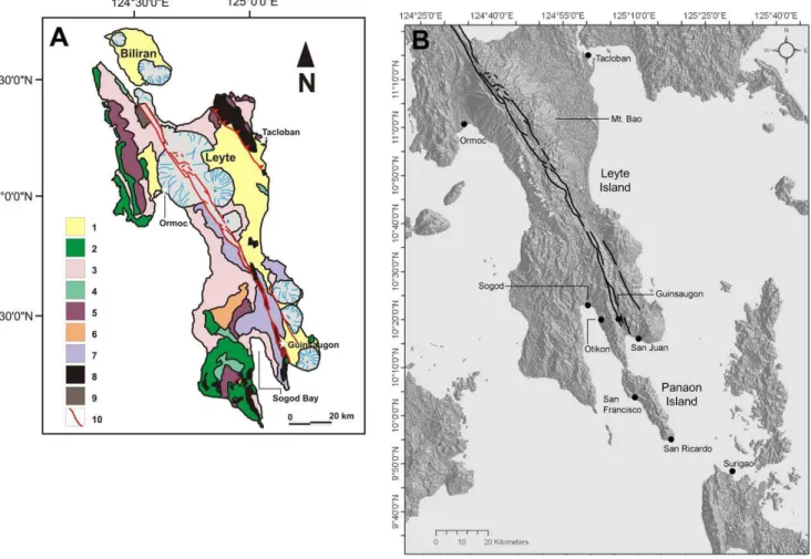
Leyte Island is located in the central part of the Philippine islands (Fig. 2). The archipelago is located in one of the most active geologic settings on earth. Three major tec-tonic elements characterize this complex oblique conver-gence environment; the Philippine Sea Plate, the Eurasian Plate and the Philippine Fault (Fig. 2). The westward moving
Fig. 1. (A) Oblique aerial view (to the northwest) of the Guinsaugon
landslide taken on 19 February 2006. (U.S. Navy photograph by M. D. Kennedy). The Himbungao River flows from right to left.
(B) View of debris toward the source area of the rockslide-debris
avalanche (Photograph taken 12 March 2006).
Philippine Sea Plate collides obliquely with the eastward moving Eurasian Plate. The result of this collision is a dou-ble subduction zone marked on the east by the Philippine Trench and on the west by the Manila Trench and its ex-tension, the Sulu Trench (Fig. 2). Rates of subduction have been estimated at 6–8 cm/yr (Aurelio, 2000). The Philip-pine Archipelago is bisected by a major strike-slip transform structure, the Philippine Fault (Allen, 1962; Barrier et al., 1991), which roughly parallels the plate boundaries that bor-der the islands (Fig. 2). Although the precise interaction be-tween the subduction zones and the strike slip faulting is not fully understood, the 1300 km long Philippine Fault appears to have formed in direct response to the oblique collision (Aurelio, 2000).
The geology of Leyte Island consists of a number of Pliocene-Quaternary volcanic cones, generally andesitic in nature, Tertiary sediments and thick successions of Tertiary volcanic and volcaniclastic rocks (Fig. 3a; Aurelio, 1992; Sajona et al., 1997). The dominant structure is the Philippine Fault (Allen, 1962; Aurelio, 1992) which bisects the island (Fig. 3). In the vicinity of Ormoc, the fault has offset the
Fig. 2. Map of the Philippine archipelago showing plate tectonic
setting, trace of the Philippine Fault (PF), other main active faults (the Sibuyan Sea Fault (SSF), the Verde Passage Fault (VF), Tablas Fault (TF)), and the location of Leyte Island (modified after Barrier et al., 1991).
northeast and southwest sectors of the ancestral Mount Bao volcano in the northern part of Leyte Island by a distance of 8 km over a period of 450 000 years (Figs. 3a, b; Duquesnoy et al., 1994; Lagmay et al., 2000).
Creep movement along the fault in the Leyte area has been measured at about 2.5 cm/year (Aurelio et al., 1997; Barrier et al., 1991; Duquesnoy et al., 1994). In Leyte Island the creep is largely aseismic. An analysis of the shear partition-ing along the fault suggests that oblique convergence is de-composed into a component perpendicular to the Philippine Trench and another parallel to the Trench and thus parallel to the Philippine Fault (Aurelio, 2000). GPS measurements in the central Philippines (Duquesnoy et al., 1994; Aurelio, 2000), suggest left-lateral displacement although an exten-sional component perpendicular to the strike of the fault was also detected which may represent non-brittle deformation of surface rocks, perhaps in response to slope movement. The topographic expression of the fault includes fault line scarps, side-hill ridges, pressure ridges parallel to the fault and asso-ciated narrow elongate depressions (Allen, 1962; Duquesnoy et al., 1994; Fig. 3b).
The Philippine Fault has been seismically active in
histor-ical times, notably in the 1990 Luzon Earthquake (Mw=7.7)
which resulted in the deaths of about 1600 people in the northern part of the Philippines (Velasco et al., 1996).
S. G. Evans et al.: Catastrophic February 2006 Philippines landslide 91
Fig. 3. (A) Geology of Leyte Island (modified from Aurelio, 1992). Key to geological units: 1 – alluvium; 2 – Pleistocene limestone;
3 – Late Miocene to Early Pliocene sediments; 4 – Middle Miocene Limestone; 5 – Late Oligocene to Early Miocene sediments; 6 – Eocene volcaniclastics; 7 – undifferentiated volcanics; 8 – ophiolite; 9 – marshland; 10 – Trace of Philippine Fault that bisects Leyte Island.
(B) Shaded relief map (based on SRTM data – for technical details see Appendix)) of Leyte Island showing the location of 17 February
Guinsaugon landslide and the trace of the Philippine Fault (thick black lines). Locations of communities mentioned in the text are also shown.
However, the seismicity of the fault is marked by spatial vari-ation in the occurrence of large earthquakes. In the Leyte area no large historical earthquake has been reported since the 17th century and seismicity appears to be dominated by shallow (<10 km in depth) small magnitude earthquakes (Inter-Agency Committee, 2006). This pattern of seismic-ity is consistent with the idea that the Philippine Fault in Leyte Island is creeping slowly rather than accumulating strain (Duquesnoy et al., 1994).
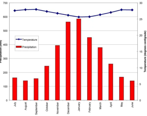
The climate of Leyte Island is characterized by high to-tal annual rainfall, episodic very heavy rains associated with tropical cyclones and almost constant warm temperatures (Fig. 4). Southeastern Leyte is characterized by Type II cli-mate under the Philippine Clicli-mate Classification (the Coro-nas Classification), i.e., no dry season and a very pronounced maximum rainfall from November to January (Fig. 4). Cli-mate data for the period 1902–2005 were obtained for Suri-gao, located within the same Type 2 zone at the northern
tip of Mindanao (Fig. 3b). Climate data from this station is believed to be representative of the southeastern part of Leyte Island, at least in broad outline. The total annual pre-cipitation is in the order of 3640 mm. The combination of warm temperatures and high rainfall results in widespread deep tropical weathering and the extensive development of residual soils throughout the Philippines (e.g., Hart et al., 2002).
3 The 17 February 2006 Guinsaugon landslide
3.1 Overview
The landslide (Figs. 1, 5) occurred between 10:30 a.m. and 10:45 a.m. on the morning of 17 February 2006. An eye-witness interviewed during field work said that the landslide started with a shaking of the ground, followed by the sound
Fig. 4. Climatic data (mean monthly precipitation and mean monthly temperature) typical of Philippine Climate Zone Type II from Surigao,
Mindanao (located on Fig. 3b). Data is summarized for the period 1902–2005 (Data obtained from Global Historical National Climate Network).
of an explosion which was in turn followed by a deafening noise similar to that of a jet engine. Initial media reports suggested that the landslide was a mudslide, debris flow, or debris avalanche. However, based on field observations, the landslide is best classified as a rockslide-debris avalanche, as defined by Hungr et al. (2001) and Hungr and Evans (2004), in which a landslide begins with a failure of a rockslope and proceeds to entrain large quantities of debris (in this case colluvium at the base of the source slope). Hungr and Evans (2004) further propose the term to describe landslides in which the Entrainment Ratio, defined by Hungr and Evans (2004) as the ratio between the volume of debris entrained from the landslide path and the bulked volume of rock frag-ments produced by the initial rock slope failure, exceeds 0.25 (see below). A rockslide-debris avalanche also involves ex-tremely rapid, massive, flow-like motion (Hungr et al., 2001) (Figs. 5a, b). Estimates of velocity by eyewitnesses suggest a mean velocity for the Guinsaugon event to be in the order of 27–38 m/s (Lagmay et al., 2006).
The topographic map generated from SRTM data (see Ap-pendix A) for this paper (Fig. 6) indicates that the rockslide-debris avalanche traveled a horizontal distance (L) of about 3.8 km (Figs. 6, 7) over a vertical height difference (H) of about 810 m (Fig. 6). This yields a fahrb¨oschung of 12◦, a
value that is identical to the field measurement of 12◦. Based
on field estimates of debris depth and an analysis of digi-tal terrain data (Fig. 6) the volume of the landslide debris is
about 15 Mm3. On a mobility plot of H/L vs. volume, these
data for the landslide plot within the 95% confidence limit calculated by Corominas (1996).
3.2 Initial failure
Detailed large-scale geological mapping has not been carried out in Southern Leyte Province. However, the 1:1 000 000 scale Geological Map of the Philippines indicates that the landslide involved initial failure of a rock slope developed in a succession of Upper Miocene-Pliocene interbedded sedi-mentary (mainly marine clastics), volcanic (mainly andesite and dacite flow rocks), and volcaniclastic rocks (tuffs and tuffites) (Philippine Bureau of Mines, 1963) that appear to dip at about 20◦to the west (Fig. 6). The direction of
land-slide movement is toward the east (Fig. 6) and thus involved the failure of the escarpment face across the bedding.
As noted above the initial failure involved a steep (48◦)
forested rock slope that forms the east facing slope of a NNW-SSE trending ridge (Figs. 7, 8). Satellite imagery and helicopter observations indicate that this sharp-crested ridge has undergone notable slope displacements (Figs. 7, 8). This is manifested in slipped masses and tension cracks along the crest of the ridge (Fig. 8). The source of the rockslide-debris avalanche is located within the damage zone (Kim et al., 2004) of the Philippine Fault; the site of the landslide is tra-versed by the main trace of the Philippine Fault (Figs. 6, 7,
S. G. Evans et al.: Catastrophic February 2006 Philippines landslide 93
Fig. 5. (A) View to the west toward the source area from
north-ern boundary of landslide of debris. (B) View from the surface of the debris toward the source area of the rockslide-debris avalanche. Characteristics of the source area are well illustrated. Particularly evident is the planar sliding surface that corresponds to a splay of the Philippine Fault. Note wreckage of buildings in foreground and the nature of the debris.
8) and it appears that a splay of the fault formed the steep sliding surface of the initial rock slope failure (Figs. 5b, 8).
Movement in the Philippine Fault zone has led to the de-velopment of thick clay-rich gouge zones in the slope, which are also noted at other locations along the Philippine Fault (Hart et al., 2002), resulting in poor rock mass quality. The rock mass in the hanging wall is visibly sheared, crushed and fragmented (Figs. 5b, 8). Thus the source area of the rockslide-debris avalanche consisted of a rock mass that had undergone active tectonic displacement of up to 2.5 cm/year which resulted in loosening, shearing, and the reduction of rock mass strength, a process described by Korup (2004) as tectonic weakening. The process contributed to the high degree of disintegration of the failed rock mass and to the high percentage of silt to clay sized particles in the rockslide-debris avalanche rockslide-debris. Grain size analyses on two samples of the rockslide-debris avalanche matrix (particles <20 mm in size) indicated that they consisted of 45% and 70% fines (silt and clay-sized material) respectively.
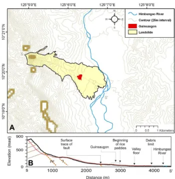
Fig. 6. (A) Map of area of Guinsaugon landslide based on SRTM
data. Holes are apparent in the digital terrain data along the ridge line (see Appendix for discussion). Outline of the landslide is based on interpretation of ASTER image collected on 1 March 2006 and GPS-controlled field traverses in March 2006. (B) Profile of rockslide-debris avalanche based on SRTM data and field measure-ments in March 2006. Line of profile is marked in Fig. 6b (S-S′).
Fig. 7. Satellite image of the landslide site (SPOT image, June
2003) with outline of the rockslide-debris avalanche (from Fig. 6a) showing pre-event conditions on the source slope and in the Him-bungao river valley.
Fig. 8. Aerial view of the sliding surface showing horizontal
stri-ations consistent with strike-slip fault movement. Note also rock mass characteristics on the right of the source area resulting from movement of Philippine Fault (Photograph courtesy of Mines and Geosciences Bureau, Government of the Phillippines).
Initial failure appears to have involved a steep promon-tory that previously existed on the slope. The failure sur-face is a crude asymmetrical wedge and involved a rock slope about 450 m in height, between el. 830 and 380 m a.s.l. (Fig. 5b). The wedge was formed by the intersection of two surfaces; the steep east dipping planar fault surface and east-west trending sub-vertical fractures. It is not clear if the line of intersection of the wedge daylighted in the slope. It is probable that the failure surface broke through a wedge of colluvium at the base of the rock slope, between el. 380 and 280 m a.s.l. (Figs. 5b, 6b, and 9). The headscarp area was inaccessible by both foot and air because it is located in ter-ritory held by New People’s Army (NPA) rebels.
3.3 Post-failure behaviour and debris characteristics
The initial rock mass slid down the steep escarpment and be-gan to disintegrate almost immediately. This is indicated by debris tongues that are diverted away from the main path very high up in the source area as the debris collided with a se-ries of side-hill ridges that mark the Philippine Fault Zone (Figs. 5 and 9). From field evidence (e.g., Fig. 5b), the mass entrained a significant volume of material from the base of the source slope beginning at el. 380 m down to just below 280 m a.s.l. We estimate this entrained volume to be in the order of about 4 M m3. If this is the case, then 11 M m3 of debris originated from the initial rock slope failure, that be-fore bulking (which we assume, after Pierson, 1998, to be 20%), had an initial in-situ volume of about 9.2 M m3. These estimates suggest an Entrainment Ratio (Hungr and Evans, 2004) of 0.36, above the suggested threshold of 0.25 neces-sary for the landslide to be described as a rockslide-debris avalanche (Hungr and Evans, 2004).
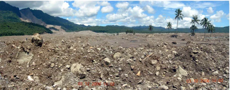
The debris began to be deposited as it traveled over rolling hummocky topography below el. 300 m a.s.l. which, on the basis of roadcut exposures immediately adjacent to the land-slide, is interpreted to represent the surface of a previous landslide deposit (cf. Fig. 1a). The thickest part of the deposit occurs between el. 200 and el. 50 m a.s.l. (Fig. 6b). In this part of the debris, which averages 10 m in thickness, the ma-terial appears to be predominantly block-supported in nature with matrix material being less dominant than in the distal part of the debris (Fig. 5a).
At a path distance of 2600 m, the rockslide-debris avalanche debris encountered flooded paddy fields on the flat valley floor in the vicinity of Guinsaugon (Fig. 7b). This had two effects; a) the debris spread out on the valley floor and thinned to a mean thickness of about 2–3 m (Figs. 1a, 9, 10) b) the undrained loading of the paddy fields led to an enhanced travel distance of 1.3 km over an almost horizon-tal surface consisting of flooded paddy fields on the valley floor (Fig. 6b). A prominent break in slope in the debris at about 2.6 km indicates considerable deposition as the debris accumulated on the slope leading to the valley floor (Fig. 6b). Debris deposited on the valley floor is dominated by finer grain sizes which forms a matrix-supported deposit (Figs. 9, 10), despite the fact that large boulders are present (Fig. 11a). This may reflect the entrainment of finer-grained collu-vium by the leading edge of the rockslide-debris avalanche from the base of the source slope and/or the mixing of the rockslide-debris avalanche debris with the saturated sedi-ments from paddy fields on the valley floor. The distal limit of the debris consists of series of irregular lobes on the flat valley floor, (Figs. 10a, b) which are rimmed by a zone of dark mud. This represents the fine muds ejected from be-neath the moving debris sheet during the final part of its travel over the paddy fields. In some places we noted that trees and buildings were destroyed by the ejected mud be-yond the limit of the coarser debris (Fig. 11b).
The debris contains large boulders up to 5 m in diame-ter, transported in some cases to the distal limit of the de-bris (Figs. 1b, 11a). As noted above, a significant part of the debris is made up of a fine-grained matrix including signifi-cant amounts of silty sand, sandy silt, and low plasticity clay (Liquid Limit = 48 and Plasticity Index = 22), reflecting the composition of the sheared source rock mass and the collu-vium entrained form the base of the rock slope.
The village of Guinsaugon (el. 35 m a.s.l.) was
over-whelmed at a path distance of 2.6 km (Fig. 6b, 7).
3.4 The trigger for the 17 February landslide
No direct trigger exists for the Guinsaugon landslide. The rockslide-debris avalanche was preceded, however, by exces-sive rainfall during the period 8–12 February 2006 (Fig. 12). Rainfall was measured at Otikon, Libagon, on the western (lee) side of the mountain ridge (for location see Fig. 3b) affected by the landslide. At this station, in the 5 day period
S. G. Evans et al.: Catastrophic February 2006 Philippines landslide 95
Fig. 9. View from near the distal limit of the debris toward the source area. Note matrix supported nature of the debris at this distal location
and flat surface, corresponding to rice paddy fields, over which the debris ran in the distal part of its path. Debris thickness here is about 2 m.
between 8 February and 12 February 2006 cumulative rain-fall reached 571.2 mm, with an average of 114 mm per day (Fig. 13). This exceeds the monthly average rainfall mea-sured both at Libagon (by a factor of two) and Surigao (by a factor of 1.2). There was, therefore, a lag time of four days between the end of the 5 day period of heavy rainfall and the occurrence of the landslide of 17 February. No analysis of the frequency of the February rainfall magnitude has been carried out but rainfalls of this magnitude and intensity are not uncommon in the Philippines, especially those related to tropical storms (typhoons) (Hart et al., 2002).
It is also noted that two small earthquakes were recorded in Southern Leyte on the day of the landslide. The first event (M 2.3), occurred 10 km northwest of the rockslide-debris avalanche at 06:07 a.m. local time, and the second, (M 2.7) occurred at 10:36 a.m., 23 km west of the rockslide-debris avalanche (Inter-Agency Committee, 2006), a time that cor-responds closely with the rockslide-debris avalanche event. These magnitudes are, however, well below those associ-ated with the occurrence of earthquake-triggered landslides (cf. Keefer, 1984).
4 Two-dimensional dynamic analysis – a first approxi-mation
A two-dimensional hindcast dynamic analysis of the 17 February rockslide-debris avalanche was carried out
us-ing the numerical model DAN (Hungr, 1995). DAN
has been used to successfully simulate the behaviour (run-out distance, velocity and debris thickness) of over 25 well-documented rock avalanches and rockslide-debris avalanches (Hungr and Evans, 1996, 2004; Evans et al., 2001). In the model, the basal resistance of the moving mass
is approximated by the selection of one of eight rheologies as outlined by Hungr (1995).
In the Guinsaugon case, we analysed the travel path in Fig. 6b. The initial failure geometry was specified as indi-cated in Fig. 6b and we assumed the immediate disintegration of the initial failure mass. This assumption was based on the brecciated nature of the source rock mass in the damage zone of the Philippine Fault and the field evidence of flowage high up in the source area as mentioned above (Fig. 6a). This assumption enabled the simulation to be carried out with a single rheology from initiation to el. 72 m a.s.l. where the debris encountered flooded paddy fields. At this point the rheology determining basal resistance was changed to sim-ulate the undrained loading of the paddy field mud by the debris sheet.
As noted above, the volume of the initial failure mass was augmented by entrainment between elevations 380 m and 280 m. Our field estimate of the entrainment volume in this part of the path (4 M m3)suggests an erosion depth of 22 m equivalent to a yield rate of 13 000 m3/m along this part of the travel path. These values were input into the DAN sim-ulation. Further, as suggested by Hungr and Evans (1996, 2004), a Voellmy rheology (Hungr, 1995) was selected to characterize the rockslide-debris avalanche behaviour from initiation to el. 72 where the flooded paddy fields were en-countered; for the simulation of this part of the path values for the friction coefficient (f ) in the range of 0.05–0.15 to-gether with a range of values for the turbulence coefficient
(ξ ) of 400–500 m/s2 were used. It is noted that these
val-ues for the Voellmy parameters are within the range of those found to best simulate the run-out distance and velocity of the majority of rock avalanche/rockslide-debris avalanche case histories analysed by Hungr and Evans (1996, 2004). At the
Fig. 10. Aerial views of distal limit of debris. (A) View east along
southern edge of debris showing muddy lobes extending out from main debris deposit onto the paddy fields on the valley floor. (B) Close-up view of distal limit of debris and wreckage of buildings. Note paddy fields. (Photograph taken on 14 March 2006).
point where the avalanche encountered flooded paddy fields, the rheology was changed from Voellmy to frictional flow
(φ=30◦), with pore pressure. We explored pore water
pres-sure conditions beneath the debris sheet for this section of the landslide path, equivalent to a range in pore pressure ra-tio (ru)of 0.5 to 0.8, to simulate the frictional loss at the
base of the debris sheet arising from the undrained loading of the paddy field mud. These values were then used in a series of simulation runs to obtain the best match for the observed characteristics of the Guinsaugon rockslide-debris avalanche.
The results of the DAN simulation are seen in Fig. 14. The run-out is precisely duplicated with Voellmy parameters of
f=0.12, and ξ =400 m/s2and with a value of ruof 0.8 for the
materials in the paddy field section of the path. The max-imum frontal velocity (58 m/s) occurred at a path distance of 942 m (Fig. 14). The duration of the movement is
esti-Fig. 11. Distal limit of rockslide-debris avalanche. (A)
character-istics of debris, including large boulder (B): damage to trees and houses by fine mud ejected from base of debris sheet, the limit of which is seen at left.
mated at 102 s for a mean velocity of 35 m/s. This compares with estimates of velocity estimates in the range 27–38 m/s noted by Lagmay et al. (2006) based on eyewitness accounts. Further, the length of the deposit, the location of maximum thickness, and the distal thinning of the debris are simulated quite well, the pattern of deposition corresponding generally to that observed in the field (Fig. 14). It is noted, however, that the maximum debris thickness obtained in the simulation is 37 m at a path distance of 1670 m (Fig. 14b). This is in con-siderable excess of the field estimate. The DAN simulation clearly overestimates the deposit thickness at the beginning of deposition in the path, possibly a model response to the effect of irregularities in the surface profile (Fig. 6b). How-ever, further downslope, the depth of burial of Guinsaugon is estimated to be 4–7 m, which corresponds to field estimates. It is also noted that the simulation indicates that the centre of gravity of the deposit is quite high up in the path (Fig. 14b), reflecting the spreading and thinning of the distal part of the debris as it encountered the flooded paddy fields.
The fact that the run-out was best predicted using an ruof
0.8 suggests that the development of excess pore-pressure by the loading of the paddy field mud by the debris sheet was a key factor in the mobility of the rockslide-debris avalanche.
In summary, the first approximation to a dynamic anal-ysis of the Guinsaugon rockslide-debris avalanche suggests that the run-out behaviour was conditioned by a) entrainment and b) the flooded paddy field effect which reduced the fric-tion at the base of the debris sheet in its distal parts. This is shown by two additional simulations using the same rhe-ological parameters as above. The result of a simulation without entrainment, but including the paddy field effect,
S. G. Evans et al.: Catastrophic February 2006 Philippines landslide 97
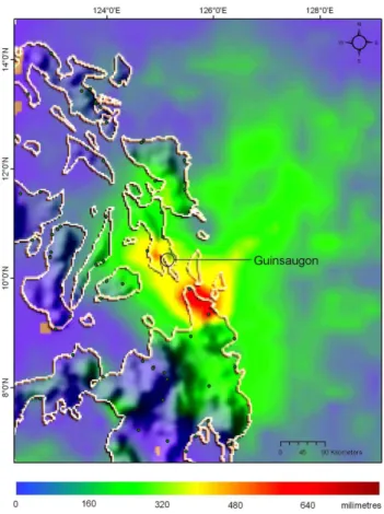
Fig. 12. Tropical Rainfall Measuring Mission (TRMM) data
show-ing accumulation of rainfall between 4 February and 17 February 2006 in the Central Philippines. (Image based on data supplied by NASA). Rainfall in Southern Leyte during this time is seen to ex-ceed 500 mm.
gave a runout distance 291 m less than the observed case (Fig. 14b), a reduction of 8%. A second DAN simulation, using a Voellmy rheology for the entire path (i.e., with-out the presence of the flooded paddy field), but including entrainment as specified above, indicated a run-out 692 m shorter than the real case, a run-out reduction of about 20% (Fig. 14b). We suggest that these simulation results demon-strate the importance of the flooded rice paddy fields as a major contributor to the enhanced run-out of the Guinsaugon rockslide-debris avalanche.
5 Implications for landslide hazard assessment
5.1 Regional and global significance
Because of heavy rainfall, active tectonics, frequent earth-quakes and extensive tropical weathering the rugged topog-raphy of the Philippine archipelago is particularly prone to catastrophic landslides. The Leyte Island rockslide-debris avalanche is the latest in a succession of landslide disasters to have affected the Philippines since 1945 (e.g.
Punong-1 2 3 4 5 6 7 8 9 Punong-10 Punong-1Punong-1 Punong-12 Punong-13 Punong-14 Punong-15 Punong-16 Punong-17 Punong-18 Punong-19 20 2Punong-1 22 23 24 25 26 27 28 1 2 3 4 5 6 7 8 9 10 11 12 13 14 15 16 17 18 19 20 21 22 23 24 25 26 27 28 0 100 200 300 400 500 600 700 800 900 1000 0 100 200 300 400 500 600 700 800 900 1000 C u m u la ti v e R a in fa ll ( m m )
Guinsaugon rock avalanche
10 20 FEBRUARY 2006 0 40 80 120 160 200 D a il y R a in fa ll ( m m )
Fig. 13. Daily rainfall and cumulative rainfall measured at Otikon,
Liagon (for location see Fig. 3b) for the period 1–28 February 2006. Horizontal dashed line is monthly mean rainfall. Data courtesy of Philippine Atmospheric, Geophysical, and Astronomical Services Administration.
Fig. 14. Results of dynamic analysis using DAN simulation model. (A) Plot of velocity along the path showing the velocity of the front
(red) and rear (blue) of the moving mass. (B) Profile is shown in black. Squares are the centres of gravity of the initial slide mass (pre-event) and of the deposit (post-event). Thickness of deposit is shown in blue. Simulated run-out distances without presence of paddy field (yellow triangle) and without entrainment (green trian-gle) are also shown. The location of the beginning of the paddy fields is shown with a black diamond corresponding to the point where the basal resistance of the moving mass is changed from a Voellmy rheology (f =0.12; ξ =400 m/s2)to a frictional one (φ=30◦)
Fig. 15. (A) Rainfall-triggered debris avalanche in residual soils that destroyed the village of Pinut-an, Township of San Ricardo, Panoan
Island, Southern Leyte Province (For location see Fig. 3b) on 23 December 2003. 209 people lost their lives in the landslide (Photograph courtesy of PCPO/PNS). (B) Cumulative rainfall for December 2003 landslide disaster in Southern Leyte Province. Rainfall measured at Otikon, Liagon (for location see Fig. 3b). Horizontal dashed line is monthly mean rainfall. Data courtesy of Philippine Atmospheric, Geophysical, and Astronomical Services Administration).
bayan et al., 2000). Major disasters struck Leyte Island in 1991 and 2003 in which over 5000 people died in rainfall-triggered landslides at Ormoc (1991) and on Panaon Island (2003; for location see Fig. 3b). In the 2003 disaster, over 350 people lost their lives in three major landslide events on Panaon Island (Figs. 3b and 15a) in the period 17–20 De-cember 2003. These landslides were triggered by very heavy rainfall; 369 mm of rain fell in just three days (18–20 De-cember, 2003), almost equal to the mean monthly rainfall of 389 mm (Fig. 15b). In addition, infrastructure in the Philip-pines is also constantly under threat from landslides resulting in high risk to lifeline facilities (e.g., Hart et al., 2002; Leynes et al., 2005).
The February 2006 rockslide-debris avalanche indicates the potential for large scale landslides (>10 Mm3)in trop-ical mountain terrain in the western Pacific region. Other examples have been reported from the mountains of Papua
New Guinea, at Bairaman (est. vol. 200 M m3; 1986; King
et al., 1989) which was triggered by an earthquake, and at Kaiapit (est. vol. 1.5 B m3; 1988) which had no discernible trigger (Peart, 1991). However, the magnitude and frequency of these types of landslides in the tropical environment is not well understood, neither are the geological controls on their spatial occurrence.
At a global scale, in terms of lives lost, the 2006 Leyte Island rockslide-debris avalanche is the most destructive single-event landslide disaster to have occurred in the world
since the 1998 Casita Volcano landslide, Nicaragua, trig-gered by the heavy rains of Hurricane Mitch. The death toll of the Casita event has been estimated at 2500 (Scott et al. 2005). With reference to the global record of single event de-structive landslides in which over a thousand people have lost their lives, the landslide is the 15th to have occurred world-wide since 1900 (Evans, 2006, and unpublished data).
5.2 Landslide hazard assessment on Leyte Island
Landslide hazard assessment on Leyte Island has at least three elements which need to be considered in a hazard as-sessment strategy;
(i) Localisation of source area; The source area of the
2006 rockslide-debris avalanche consisted of rocks from the damage zone of the Philippine Fault, an active strike slip fault that is moving at 2.5 cm/yr. In fact the sliding surface was a splay in the fault. Field evidence indicated the presence of other rockslide-debris avalanche deposits in the Humbun-gao valley (Fig. 1a). The combination of high steep slopes consisting of rock masses that are subject to active tectonic shearing (tectonic weakening) suggests a high potential for large scale rock slope failure along the damage zone of the Philippine Fault.
(ii) Post-failure behaviour; The February 2006
rockslide-debris avalanche also indicates that the presence of flooded paddy fields in valley bottoms may enhance the travel
S. G. Evans et al.: Catastrophic February 2006 Philippines landslide 99 distance of flow-type landslides through decreased frictional
resistance at the base of the debris sheet by undrained load-ing.
(iii) Trigger and warning; The rockslide-debris avalanche
occurred as a delayed response to a 5 day period of unusu-ally heavy rains. The lag time has implications for landslide warnings based on expected rainfall occurrence and inten-sity. The heavy rains were part of the 2005–2006 La Nina phenomenon and thus the occurrence of the rockslide-debris avalanchemay be viewed as a local response to a sub-global climatic phenomenon (ENSO).
6 Conclusions
The occurrence and behaviour of the disastrous Guinsaugon rockslide-debris avalanche was determined by the intersec-tion of geological/tectonic, climatic and cultural factors.
With reference to geological/tectonic elements, the
rockslide-debris avalanche originated in rocks within the damage zone of the Philippine Fault, an active strike-slip fault that shows a rate of movement of about 2.5 cm/yr. The sliding surface of the initial rockslide corresponds to a splay in the trace of the Philippine Fault. As such, the source rock mass was of low rock quality resulting from the shearing and brecciation associated with fault movement. This fact, and the presence of older rockslide-debris avalanche deposits on the valley floor parallel to the fault, not only raises the possi-bility of future catastrophic landslide events along the Philip-pine Fault on Leyte Island but also the question of the mag-nitude and frequency of past events.
With respect to climate, the lag time between the end of the period of heavy rainfall and the occurrence of the rockslide-debris avalanche is also of interest as it presents problems in determining threshold rainfall for landslide occurrence and the issuance of associated appropriate warning measures.
Agricultural development in the valley bottom had a ma-jor effect on the run-out of the rock avalanche. In terms of post-failure behaviour, the run-out of the rockslide-debris avalanche was enhanced by undrained loading of rice paddy fields on the valley floor beneath the debris sheet. This led to a spreading and thinning of the rockslide-debris avalanche debris.
The 2006 rockslide-debris avalanche is one of several disastrous landslides to have occurred in the Philippines in the last twenty years confirming the Philippines as one of the landslide hotspots in the world (cf. Nadim et al., 2006). In terms of loss of life, the Guinsaugon rockslide-debris avalanche is the most devastating single-event land-slide to have occurred worldwide since the Casita Volcano rock avalanche-debris flow which was triggered by Hurri-cane Mitch in Nicaragua in 1998.
Finally, work carried out on the landslide illustrates the utility of readily-available optical space-borne imagery and orbitally-collected digital terrain data in the rapid
characteri-sation of a major catastrophic landslide in support of detailed field work.
Appendix A
The rapid characterisation of the Guinsaugon Landslide – methodology and data sources
The rapid characterisation of the Leyte Island landslide was made possible by the availability of a variety of space-borne imagery and data augmented by field work. Topographic data was derived from the Shuttle Radar Topography Mis-sion (SRTM) digital elevation model (DEM), which has a 3 arcsecond (∼90 m) spatial resolution in both latitude and longitude, and an absolute height accuracy better than 16 metres (90% confidence). Although SRTM data is of rea-sonably good coverage, some data anomalies exist and re-flect the method of data collection (Interferometric Synthetic Aperture Radar; InSAR). Errors include missing data result-ing from shadows, layover, and poor surface reflective prop-erties for microwave radiation. Gaps in the data set appear most commonly in areas of rough terrain, especially along ridgelines. This is evident in Fig. 6. Analysis of the head scarp of the landslide using the SRTM data was complicated by voids in the topographic data.
Orbital optical imagery from both before and after the event are available. Both the pre- and post-disaster images were geo-referenced to the UTM zone 51 N. As is commonly the case for both near-equatorial and mountainous regions, cloud cover was a complicating factor in collection of post-disaster imagery having high utility – at the time of submis-sion, only one cloud free ASTER scene collected on 1 March 2006, of the many ASTER scenes collected at the location, was available.
Pre-disaster imagery (Fig. 7) was a SPOT scene provided by the European Space Agency. The high resolution (10 m mutispectral, 5 m panchromatic) orthorectified SPOT 5 im-age (030601 00148057004) was imim-aged on 1 June 2003. Vi-sual analysis of pan-sharpened colour infrared composites provided best interpretation results.
A post-disaster ASTER (Advanced Spaceborne
Thermal Emission and Reflection Radiometer) scene
(00303012006021025 03122006120419) was used, in
association with field data, to delineate the limits of the landslide. The scene, imaged on 12 March 2006, was the first known orbital image clearly showing the majority of the landslide. Georectified visual and near infrared bands (15 m resolution) were interpreted as a colour infrared composite. The localized cloud cover along the ridge from which the rockslide-debris avalanche initiated obscured some of the source area and the entire head scarp. Consequently, field observations were the main source of observation for this
part of the landslide. These observations were carried
GPS-controlled ground traverses of the debris and aerial inspection by helicopter.
Acknowledgements. This paper is based on field work carried out
on Leyte Island, Philippines between 10 and 16 March 2006. We wish to acknowledge the Asia Pacific Initiative Fund of Foreign Affairs Canada for funding the field expedition to the Philippines. We thank the Canadian Space Agency for providing space imagery under the International Charter for Space and Disasters. Also we thank NASA for supplying TRMM data for Fig. 12. In the Philippines, we gratefully acknowledge the assistance of the Mines and Geosciences Bureau of the Philippine Department of Environment and Natural Resources, especially E. Domingo. In addition we thank M. Lim, the Mayor of St Bernard for her support and facilitating our work at the Guinsaugon site, and Governor R. Lerias (Southern Leyte Province) and her staff in Maasin City for assistance. We acknowledge the assistance of the Philippines Armed Forces, under the command of Major-General B. Ramos, in providing helicopter reconnaissance of the landslide. The simulation was carried out using DAN-W (Release 4) and we are grateful to O. Hungr for supplying a copy of the software. Finally, we thank the Philippine Atmospheric Geophysical and Astronomical Services Administration (PAGASA) for rainfall data on which Fig. 13 and 15B are based.
Edited by: G. Wieczorek
Reviewed by: D. Petley and another referee
References
Allen, C. R.: Circum-Pacific faulting in the Philippines-Taiwan re-gion, J. Geophys. Res., 67, 4795–4812, 1962.
Aurelio, M. A.: Tectonique du segment central de al faille Philip-pine (etude structurale, cin`ematique et evolution geodynamique), These de Doctorat, Universite Pierre et Marie Curie, Paris, France, 500 p., 1992.
Aurelio, M. A.: Shear partitioning in the Philippines: constraints from Philippine Fault and global positioning system data, The Island Arc, 9, 584–597, 2000.
Aurelio, M. A., Barrier, E., Gaulon, R., and Rangin, C.: Deforma-tion and stress states along the central segment of the Philippine Fault: implications to wrench fault tectonics, J. Asian Earth Sci., 15, 107–119, 1997.
Barrier, E., Huchon, P., and Aurelio, M. A.: Philippine fault: a key for Philippine kinematics, Geology, 19, 32–35, 1991.
Bautista, M. L. P. and Oike, K.: Estimation of the magnitudes and epicenters of Philippine historical earthquakes, Tectonophysics, 317, 137–169, 2000.
Corominas, J.: The angle of reach as a mobility index for small and landslides, Can. Geotech. J., 33, 260–271, 1996.
Duquesnoy, T., Barrier, E., Kasser, M. Aurelio, M. A., Gaulon, R., Punongbayan, Rangin, C., and the French-Philippine Coopera-tion team: DetecCoopera-tion of creep along the Philippine Fault: first results of geodetic measurements on Leyte Island, central Philip-pine, Geophys. Res. Lett., 21, 975–978, 1994.
Evans, S. G.: Single-event landslides resulting from massive rock slope failure: characterizing their frequency and impact on so-ciety, in: Landslides from massive rock slope failure, edited by:
Evans, S. G., Scarascia-Mugnozza, G., Strom, A. L., and Her-manns, R. L., Springer, Dordrecht, pp. 53–73, 2006.
Evans, S. G., Hungr, O., and Clague, J. J.: Dynamics of the 1984 rock avalanche and associated debris flow on Mount Cayley, British Columbia, Canada; implications for landslide hazard as-sessment on dissected volcanoes, Eng. Geol., 61, 29–51, 2001. Hart, J., Hearn, G., and Chant, C.: Engineering on the precipice:
mountain road rehabilitation in the Philippines, Quart. J. Eng. Geol., 35, 223–231, 2002.
Hungr, O.: A model for the runout analysis of rapid flow slides, de-bris flows and avalanches, Can. Geotech. J., 32, 610–623, 1995. Hungr, O. and Evans, S. G.: Rock avalanche runout prediction using
a dynamic model, Proc. 7th Int. Symp. on Landslides, 1, 233– 238, 1996.
Hungr, O. and Evans, S. G.: Entrainment of debris in rock avalanches: an analysis of a long run-out mechanism, Geolog-ical Society of America Bulletin, 116, 1240–1252, 2004. Hungr, O., Evans, S. G., Bovis, M. J., and Hutchinson, J. N.: A
re-view of the classification of landslides of the flow type, Environ. and Eng. Geosci., 7, 221–238, 2001.
Inter-Agency Committee on the Guinsaugon, Southern Leyte, Landslide Tragedy: The 17 February 2006 Bgy. Guinsaugon, Southern Leyte, Landslide, February 28, 2006, Government of the Philippines, 18 p., 2006.
Keefer, D. K.: Landslides caused by earthquakes, Geol. Soc. Am. Bull., 95, 406–421, 1984.
Kim, Y.-S., Peacock, D. C. P., and Sanderson, D. J.: Fault damage zones, J. Structural Geol., 26, 503–517, 2004.
King, J., Loveday, I., and Schuster, R. L.: The 1985 Bairaman land-slide dam and resulting debris flow, Papua New Guinea, Quart. J. Eng. Geol., 22, 257–270, 1989.
Korup, O.: Geomorphic implications of fault zone weakening: slope instability along the Alpine Fault, South Westland to Fiord-land, New Zealand J. Geol. Geophys., 47, 257–267, 2004. Lagmay, A. M. F., Tengonciang, A. M. P., Marcos, H. V., and
Pascua, C. S.: A structural model guide for geothermal explo-ration in Ancestral Mount Bao, Leyte, Philippines, J. Volcanol. Geotherm. Res., 122, 133–141, 2000.
Lagmay, A. M. F., Ong, J. B. T., Fernandez, D. F. D., Lapus, M. R., Rodolfo, R. S., Tengonciang, A. M. P., Soria, J. L. A., Baliatan, E. G., Quimba, Z. L., Uichianco, C. L., Pagluican, E. M. R., Remedio, A. R. C., Lorenzo, G. R. H., Valdivia, W., and Avila, F. B.: Scientists investigate recent Philippine landslide, Eos, 87, p. 121, 124, 2006.
Leynes, R. D., Pioquinto, W. P. C., and Caranto, J. A.: Land-slide hazard assessment and mitigation measures in Philippine geothermal fields, Geothermics, 34, 209–221, 2005.
Nadim, F., Kjekstad, O., Peduzzi, P., Herold, C., and Jaedicke, C.: Global landslide and avalanche hotspots, Landslides, 3, 159– 173, 2006.
Peart, M.: The Kaiapit landslide: events and mechanisms, Quart. J. Eng. Geol., 24, 399–411, 1991.
Philippine Bureau of Mines: Geological Map of the Philippines, Scale 1:1 000 000, 1963.
Pierson, T. C.: An empirical method for estimating travel times for wet volcanic mass flows, Bull. Volcanol., 60, 98–109, 1998. Punongbayan, R. S., Arboleda, R. A., Bornas, M. V., and Abigania,
M. T.: The 3 August 1999 Cherry Hills Landslide in Antipolo City, Philippines, Landslide News, 13, 12–15, 2000.
S. G. Evans et al.: Catastrophic February 2006 Philippines landslide 101
Sajona, F. G., Bellon, H., Maury, R. C., Pubellier, M., Quebral, R. D., Cotten, J., Bayon, F. E., Pagado, E., and Pamatian, P.: Ter-tiary and Quaternary magmatism in Mindanao and Leyte (Philip-pines): geochronology, geochemistry and tectonic setting, J. Asian Earth Sci. 15, 121–153, 1997.
Scott, K. M., Vallance, J. W., Kerle, N., Macias, J. L., Strauch, W., and Devoli, G.: Catastrophic precipitation-triggered lahar at Ca-sita volcano, Nicaragua: occurrence, bulking and transformation, Earth Surf. Proc. Landforms., 30, 59–79, 2005.
Velasco, A. A., Ammon, C. J., Lay, T., and Hagerty, M.: Rupture process of the 1990 Luzon, Philippines (Mw=7.7), earthquake, J.