HAL Id: halshs-00459041
https://halshs.archives-ouvertes.fr/halshs-00459041
Submitted on 23 Feb 2010
HAL is a multi-disciplinary open access archive for the deposit and dissemination of sci-entific research documents, whether they are pub-lished or not. The documents may come from teaching and research institutions in France or abroad, or from public or private research centers.
L’archive ouverte pluridisciplinaire HAL, est destinée au dépôt et à la diffusion de documents scientifiques de niveau recherche, publiés ou non, émanant des établissements d’enseignement et de recherche français ou étrangers, des laboratoires publics ou privés.
Benchmarking urban networking strategies in Europe
César Ducruet
To cite this version:
César Ducruet. Benchmarking urban networking strategies in Europe. The Korea Spatial Planning Review, 2006, 49 (1), pp.3-24. �halshs-00459041�
Benchmarking urban networking strategies in Europe
An application of chorems to France and Great Britain
Published in: The Korea Spatial Planning Review 49(1), pp. 3-24
César Ducruet, PhD, KRIHS
Summary
In the 1990s in Europe, several initiatives from local governments have been launched under the general term of
urban networking, promoting governance renewal and aiming at a better management of hierarchical forces
stemming from globalization, resulting in territorial competition and unbalance. However, few studies have
evaluated the achievements of such partnerships. This paper argues that the degree of territorial integration of
the area within which the strategy takes place is one of the most important factor of its success. A case study of
Normandie Métropole (France) and South Coast Metropole Partnership (England) is proposed, using the
particular methodology of chorems for spatial analysis. It appears that the hypothesis is well confirmed as the
Norman case, suffering from a lack of integration, has been less efficient than the English one for achieving its
goals.
Keywords: Central southern England, Chorem, Normandy, Territorial integration, Urban networking
Introduction
In a era of globalization, local governments are competing to increase their attractiveness for economic activities. Every city can be considered to belong to a global urban hierarchy, dominated by a few higher-ranked “global cities”. At the same time, cities are not disconnected from a national and regional environment where they share specialized functions with other cities. These two principles – global hierarchy and regional specialization – are interdependent but some authors have insisted on the risk for cities to rely more on the global economy than on their traditional ties with their hinterland, creating uneven competition among cities and regions (Fujita et al., 1999).
In this respect, some cities – and notably second-ranked cities – have launched in the 1990s innovative policies through partnerships rather than through individual promotion: these “inter-city partnerships” or “urban networkings” generally aimed at valuing a common set of interests from several local governments, partly derived from their regional identity. Such policies are inspired by historical examples such as the Hanseatic League in Middle-Age Scandinavian Europe1, the Italian industrial districts2 from the 19th century and the
Randstad Holland3 in Netherlands.
Numerous urban networking experiences have emerged, like the Nordregio project (Baltic sea region), the Bothnian Arc4, the Conference of Peripheral Port Cities5, and the
cultural network of Eurocities. Some other partnerships are more or less clearly identified and usually involve not cities but provinces, like in the case of the Atlantic Arc, the
Mediterranean Arc and the Channel Arc, which are other types of cross-border cooperation.
In France, a total of 24 urban networking associations have been created between 1989 and 2000, covering 107 local governments (see Table 1). Another example is the Association of
One Hour Cities from Paris6 which attempted to resist to Paris primacy but without
significant achievements. Some urban networkings in Europe are part of a national territorial policy, like in France (Fabre 1991; Hau-Rouchard et al., 1996), or come from The European Commission itself, like Nordregio within the framework of Interreg IIc programme. Other ones are local initiatives, like the South Coast Metropole Partnership in England.
In all cases, local governments are seeking for overcoming their difficulties by associating with other local governments which have either similar problems or are simply neighbors, through the implementation of renewed governance. The difference with spontaneous urban networks (i.e. passive cooperation through economic ties only) is the
1
The cooperation of several merchant cities of North and Baltic seas from the 12th to the 17th centuries.
2
More than 120 districts can be found in Italy, involving several small cities and types of cooperation.
3 Amsterdam, Rotterdam, The Hague and Utrecht form a cooperative urban system. 4 28 small Finnish and Swedish local governments
5
Brest, Cadiz, Den Helder, Plymouth, Tarento, Constantza, Dun Laoghaire, Kiel, region Norte, Gdynia, Klaipeda
political dimension of these voluntary associations, acting as lobbies among already existing planning institutions.
Table 1: List of French urban networkings (Source: French National Club of Urban Networkings7)
Name of urban networking Date of
creation Member cities
Annual budget (€)
Aire 198 1989 Angoulême, La Rochelle, Niort, Poitiers 123,000 Albi-Castres-Mazamet-Rodez 1999 Albi, Castres, Mazamet, Rodez 123,000 Alpes du Sud 1995 Château-Arnoux, Digne-les-Bains, Gap, Manosque,
Sisteron 70,000
Association Limoges-Poitiers 1998 Limoges, Poitiers 15,000
Charente Océan 1992 Cognac, Saintes 85,000
CVCGARA8 1992 Annecy, Bourg-en-Bresse, Chambéry, Grenoble, Lyon,
Roanne, Saint-Étienne, Valence 300,000 Conférence des Villes de
Bretagne 1995 28 cities in Brittany N/A
Côte d‟Opale 1996 Montreuil, Boulogne-sur-Mer, Calais, Dunkerque,
Saint-Omer 1,500,000
Estelle sud Massif Central 1994 Aurillac, Mende, Rodez 75,000 La Rochelle-Rochefort 1996 La Rochelle, Rochefort 60,000 Les Perles Vertes de l‟A75 1999 Issoire, Saint-Flour, Marvejols, Millau, Lodève, Pézenas 150,000 Le Triangle 1993 Bar-le-Duc, Saint-Dizier, Vitry-le-François 150,000 Le Triangle d‟Oc 1996 Béziers, Narbonne 108,000 Limousin Axe Majeur 1998 Limoges, Brive-la-Gaillarde, Tulle, Guéret 135,000 Nîmes-Arles-Avignon - Nîmes, Arles, Avignon N/A Normandie Métropole 1993 Caen, Rouen, Le Havre 92,000 Oise-la-Vallée 1989 Compiègne, Creil, Chantilly, Senlis 739,000 Réseau Culturel des Villes de
Picardie 1995 Abbeville, Amiens, Beauvais, Saint-Quentin N/A
TGVILLES R.A.F.H.A.E.L. 1995
Arras, Avesnes-sur-Helpe, Boulogne-sur-Mer, Cambrai, Douai, Dunkerque, Liévin, Lille, Mons (Belgium), Roubaix, Tourcoing, Valenciennes, Villeneuve-d‟ascq
70,000
Réseau Développement des
Villes du Centre 1990 33 cities in Centre region 123,000 Réseau des Villes de
Guyenne N/A
Agen, Bergerac, Périgueux, Villeneuve-sur-Lot, Libourne,
Marmande, Nérac N/A
Réseau des Villes du Maine 1999 N/A N/A
Rhin Sud N/A Belfort, Montbéliard, Colmar, Mulhouse, Héricourt,
Saint-Louis N/A
Sens-Fontainebleau-Montereau-Montargis N/A Sens, Fontainebleau, Montereau, Montargis N/A Sillon Alpin 1993 Grenoble, Chambéry, Aix-les-Bains, Annecy, Annemasse,
Genève N/A
Sillon Lorrain 2000 Metz, Nancy, Epinal, Thionville N/A Villes d‟Oc et du Quercy 1999 Cahors, Brive-la-Gaillarde, Montauban, Gourdon, Souillac 5,000
Villes Moyennes de Bretagne 1990 N/A N/A
It is interesting to evaluate to what extent these associations, since their creation, have been able to find their place among other planning tools, and how they have been able to
overcome the growing individualistic behavior of urban policies. Even though the success of such strategies is known to be very diverse, there is still no attempt to propose an evaluation, but the topic is still popular especially in Europe9.
This paper is proposing a comparison based on the cases of Normandie Métropole (France) and South Coast Metropole Partnership (England), which share similar spatial characteristics like maritime border, proximity to global city-regions (London and Paris) and regional administrative division of their outlying area. Despite such resemblance, it appears that their achievements are unequal. This paper argues that beyond economic, political and cultural factors, the degree of territorial integration of the area within which an urban networking is conducted is the key for reaching the project‟s objectives. Territorial integration is here understood as the process defined by Brunet (1997): “connecting, supporting interrelationships and reducing disrupts and distances between elements which, however, keep their own identity (…) An integrated territory corresponds to a number of places correctly linked with each other and with decision centers; all its parts are correctly irrigated with services, goods, information, labor facilities ; products of any kind efficiently drained and redistributed”.
The chosen methodology is based on a particular way of representing spatial structures and dynamics, named “chorems” in French geography and defined as “elementary structures of geographical space” (Brunet, 1980). Then, the concept of urban networking is introduced as a framework for policy evaluation (section 1) as well as the principles of the methodology (section 2), before introducing and conducting the case study (section 3) and giving some concluding remarks about the relevancy of this kind of policy and the effectiveness of “chorems” to analyze such an issue.
9 See for example the Conference on Urban Partnership and Urban Governance 3-5 May 2006 , Stockholm,
1. The concept of urban networking
Urban networking is commonly defined as an association of several municipal governments aiming at strengthening their attractivity towards bigger cities, through economies of scale, complementarity and innovation: “Generic term which, to the broadest meaning, focuses on a group of cities linked together by various relationships. The nature of the city network and the intensity of these relationships determine the link between the group of cities and the outlying territory. The notion of inter-city networking thus becomes operational when the nature, the type of relationships and the group of the cities concerned are defined” (Le Berre, 1992). An urban networking does not confound itself with the whole urban network of a regional area or province; selected cities of an urban network create a new institution and conduct a common policy (May, 1993).
A variety of definitions and principles have been proposed (see Table 2) in terms of conditions, strategies and goals. The condition for networking is either spatial (distance) or economical (functions), the strategy can be economical (growth), political (sharing common ideas) or cultural (territorial development), but the goals are usually either to compete with bigger cities or to limit the competition within the group itself.
Table 2: Multiple definitions of urban networking
SOURCE CONDITION STRATEGY FINAL GOAL
D.A.T.A.R.
(1991) Spatial closeness Voluntary cooperation
Solve the difficulties to reach an objective individually
M. Le BERRE
(1992) Existing relationships Territorial development Promote a regional identity
N. MAY (1993) Growth poles
Growth strategy in public policy areas (e.g. transport, research)
Participate to metropolisation and externalization dynamics
R. CAMAGNI (1993) Non hierarchical economic interdependence Economies of agglomeration and scale
Distribute horizontally the benefits between partners
J.-M. OFFNER and D. PUMAIN
(1996)
Partial urban network Research of possible functional linkages
Reach a critical mass, extract the value added of the system
D. PUMAIN and T. St JULIEN
(1996)
Functional, physical or
personal networks Mutual support
Reduce the perverse effects of urban competition
Another conceptual insight in the concept has been provided by Brunet (1996) and is synthesized in Table 3. His work includes different types of networks like those of cities, firms, and any type of network association resulting from spatial and economical processes. In particular, Brunet gives a special importance to qualitative aspects, such as skills and territorial management, so as to reduce the importance of a strategy based on reinforcing inequalities. Then, the attraction of service activities and firms, as exogenous forces, may not re-equilibrate the existing urban network, compared to endogenous projects aiming at developing lacking facilities (e.g. regional airport, missing expressway linkages) and at valuing the already existing functions of the cities after finding in which ways they might combine within a horizontal relationship. Then, the success of urban networking is based on spatial organization, economic functions, and the dynamics of change that are both endogenous and exogenous. This paper‟s task is then original compared to usual evaluation procedures based on financial reports (Unal, 1998).
Table 3: Different types of urban networking strategies (Source: adapted from R. Brunet, 1996)
TYPE STRATEGY FINAL GOAL RISK
Hierarchy of services
Concentration of service provisioning, territorial
management
Reach a critical
mass Increased hierarchy
Spatial division of labor Economic system segmentation Specialization and production
Domination by the firms
Comparable and
competing cities Value and share individual skills Synergy
Unequal quality of accessibility and
infrastructure
Group of interest Lobbying and auto valorization Promotion of
common interests Short term
Single project Elaboration and development of a
common project Common profit Uneven benefit
Sharing Coordination for sharing activities and facilities
Strengthen a „regional system‟
Geographical remoteness of cities
(in some cases)
2. Methodology: a brief introduction to chorems
According to its inventor, chorematics is defined as the “science and art of chorems” (Brunet, 1980). A chorem is an “elementary structure of geographical space” which aims to be combined with other chorems in order to highlight spatial organizations. This approach has flourished due to the lack of graphical rules among geographers, as a “spatial graphical vocabulary” (one idea by one chorem) to be used both for research and planning. The main advantage of chorems is to be relevant at any geographical level and to facilitate the comparison of spatial systems thanks to a simple representation of complex organizations. They can be associated to previous modeling like in the works of Christaller, Von Thünen, Park, Burgess and the Chicago School models. The major difference is that chorems can be combined to represent either a general type of organization (e.g. the colonial city) or a particular place (e.g. Bangkok). However, chorems have been often criticized as they tend to ignore non spatial factors in order to explain the logic of a spatial system, like the cultural
and political ones. According to Brunet, chorems have never pretended to be an end in itself, but a tool to better communicate between geographers and between different disciplines, focusing about spatial “rules”. The search for recurrent spatial organizations have led this sub-discipline to produce several tables of chorems (Brunet, 1980; Brocard, 1992; Fontanabona, 1994; Cheylan, 1996; Ducruet, 2005). Their related applications include the general model of the tropical island (Brunet, 1991), the European estuary (Brocard et al., 1995), the global city (Mangin, 2001), the South Asian port metropolis (Eliot, 2003) and the European port city (Ducruet and Jeong, 2005). The most famous application, the “blue banana”, aimed at showing the European core-periphery pattern in terms of capital, market, population and infrastructure density, with a corridor ranging from London to Milano; it led to a scandal as Paris and most of the French territory were excluded of the model. In France, the institution in charge of national territorial planning10 has often used chorems in its
representations of French territory so as to propose spatial scenarios for the next decades. A synthetic grid (Figure 1) is briefly introduced as to explain the main possibilities of such method, that are applied in the next section. In columns, three modes of spatial organization (point, line, area) and two levels of spatial complexity (system, model) are distinguished. In rows, several entries encompass the majority of already existing chorems, plus a number of new ones, but it is not necessary to introduce all of them before their application to urban networking strategies.
Classical spatial models are the region, the gravitation model, the central place model and the core-periphery model, each of them being a combination of several chorems. Other spatial models are built on some variants, such as sectors (irregular settlements), polynuclear (fusion of multiple centers), extraversion, exchanges (effects of specialization and interface location) and decentralization (planning policy accompanied with deconcentration).
The principle of chorems is to be serve the simplified representation of reality so as to demonstrate phenomena that cannot be revealed by usual graphical tools such as maps, diagrams and statistical analysis. Especially, chorems represent concepts rather than variables. Their content is much more qualitative than quantitative, but they can be inspired of all kinds of sources as long as they are relevant for the demonstration like in any scientific procedure. Of course, chorems require some graphical skill during the process of adapting them to the case studied. Their advantage is to help finding which principle(s) underlie a spatial organization or phenomenon through gradual steps of investigation. Each chorem is a step of demonstration. At the end, the harmonious combination of chorems leads to a synthetic map with major structures and dynamics.
The general model of the European estuary‟s spatial organization (Brocard et al., 1995) showed in Figure 2 provides a good example. European estuaries (e.g. Seine, Severn, Solent, Gironde, Maas, Loire…) have undergone similar changes to attain a similar spatial structure and face similar stakes for their future developments. For instance, the downstream shift of port activities has privileged the development of only one river bank for transportation and industrial functions, creating an unbalanced spatial system between upstream/downstream cities and between the two banks. Policy recommendation is the planning of a path crossing the estuary (e.g. Normandy bridge) so as to re-equilibrate the system to the advantage of the seaport city, which is usually less attractive than the older upstream city, and of the other bank.
Figure 2: Spatial model of the European estuary using chorems (Source: Brocard et al., 1995)
It is seen here that chorems have also an heuristic value that goes beyond simplification and description; their task is to indicate planning problems and the way to overcome them.
3. Application to Normandy Métropole and South Coast Metropole Partnership
3.1 Presentation of the two associations
* History and respective goals
Normandie Métropole (NM) has been created in 1993, following a first official meeting of the three city mayors in 1990 (Caen, Rouen, Le Havre)11. In 1997, a scientific
committee composed of university researchers has been created so as to address major common tasks. The network has a yearly assembly and its administration council meets two times a year. In order to realize its goals, NM aims at mobilizing several players around common projects in the fields of infrastructure, research, education and technology. Its actions and achievements shall be presented to the area‟s public and private partners on a
regular basis. Its objectives are to elaborate a development dynamic to foster cultural, tourist and economic cooperation between the three cities, so as to :
- increase its role within European and national territory;
- define balanced relationships with other areas of the Paris basin;
- closely participate to the development and planning of respective regions;
- constitute a balanced metropolitan area in the framework of the Seine estuary Territorial Planning Directive.
South Coast Metropole Partnership (SCMP) was formed in 1993 as a strategic local authority alliance of Bournemouth, Poole, Portsmouth and Southampton councils12. Its main
objective is to “develop the economy and prosperity of the Central South Coast of England and to raise the region's profile as a distinctive entity in Europe and internationally”13. Its role
is to promote and implement projects and campaigns that strengthen the regional economy, including:
- improving communication links and infrastructure to UK and mainland European business markets;
- cooperating with the private sector, by encouraging the expansion of local companies and sustainable inward investment notably for R&D cluster centers and high-tech companies in IT, telecommunications, marine engineering and defense systems;
- upgrade the quality of life with a wide range of urban center, rural and waterfront retail options together with leisure plus sailing events and active cooperation with commercial property market agents and developers;
12 The urban networking formerly included the Isle of Wight County Council. 13 http://www.englandsouthcoast.co.uk
- raising the region‟s profile and establishing a wider international focus through actions like Europartneriat14, Applicom15 and the New South Alliance in 1997 with Labrador
and Newfoundland government (Canada).
In this respect, NM and SCMP are very different in their objectives. On one side, NM‟s major interest is to act as a levy for balanced territorial organization at the scale of both Paris region and Seine estuary area (Brocard, 2000), and plans to integrate the three cities by concerting with mostly public players. On the other side, SCMP is totally turned towards regional and foreign private players so as to promote economic development and attract EU funding. Such differences come from the very diverse culture of governance of the local governments. In France, cities (communes) are not “educated” for promotion because their main task is to raise the standard of public service and territorial equality, and they have the power to do so since the decentralization laws of 1982. In England, local governments still depend on central government‟s budget, that tends to push local authorities to find ways for attracting additional budgets through increased cooperation with the private sector. This has some limits, as Southampton City Council has been blamed recently by central government for selling too much land to commercial developers throughout the city. Then, urban networking is a symbol of English “partnership culture” (Charlesworth and Cochrane, 1994), motivated by the absence of a regional integration concept in England (Clout, 1994; Allen et al., 1998). Inversely, French decentralization tended to give more power to local and regional governments so as to forge their own destiny, but it didn‟t help to foster inter-city or interregional partnerships. Then, the high number of urban networking initiatives in France shall be interpreted as an effect of Paris centralization rather than the emergence of
14
Organized by the European Commission, the purpose of Europartenariat is to stimulate the development of less-favoured regions or those suffering from industrial decline or those from rural parts or regions with low population density (objectives 1, 2, 5b and 6), by encouraging small and medium-sized businesses from all over the Community and third countries to establish business relationship with their counterparts in these regions.
operational bodies working jointly with the private sector. Most of them are limited in their scope and budget given the strong individualist character of local governments. The regional context is another source of difference between the two associations.
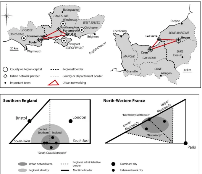
* Regional context
Normandy and central southern England have in common their non existence as homogenous administrative regions. Normandy is divided between two Regions (Upper and Lower Normandy) made of five Departments (Seine-Maritime, Eure, Orne, Calvados and Manche) while central southern England is divided between the Southeast and Southwest Standard Regions including the Counties of Hampshire, Dorset, Isle of Wight and West Sussex (Figure 3). Normandy has existed as a single region (10th century) with a strong
cultural identity, but central southern England, apart from its partial belonging to the former Wessex kingdom (9th century), has never been clearly delimitated and is more likely to cover
a broad economic area between London and Bristol, as part of the UK “sunbelt”. Acute debates still linger on both sides of the Channel, about the reunification of Normandy and the creation of a central southern England Standard Region for more regional autonomy.
Figure 3: Location of the two partnerships
The fact that Norman universities have formed a sustainable alliance for student exchange and research partnerships, does not come from the willingness of the urban networking. On the other side, the “Central Southern England Regional Alliance” (CSERA) does include officially the urban network among its partners, together with universities, the port of Southampton, and the chambers of commerce.
In the 19th century, Normandy has acquired a tourism function with the emergence of
seaside resorts for Parisian visitors, like for the Isle of Wight and the Bournemouth area welcoming the British royal family since early times. Another common feature is the port function, with Le Havre, Rouen, Southampton and Poole as commercial ports and Portsmouth, Cherbourg as ferryports and former naval bases. The Cowes‟ week festival in the
Isle of Wight for yachting, and the Liberty Armada in Rouen for the welcoming of old ships are major events sustaining the maritime identity of the two areas.
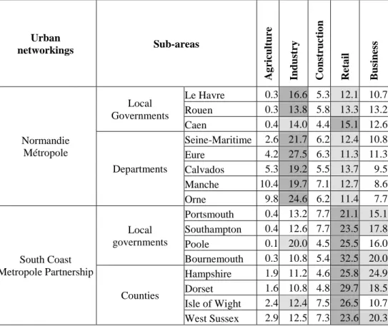
The major difference between the two areas is their recent history as economic regions as seen in Table 4. Norman cities (except Caen) and departments are specialized in industrial activities while English ones are all specialized in commercial activities. It is the result of very diverse dynamics since the 1960s. On one side, the industrial deconcentration from Paris region (blue collars) has spread along the Seine river, major corridor for import and export, based on heavy industry and mass production, except for Caen, which remains an administrative center in the middle of a rural region. On the other side, the diffusion of services (white collars) has spread towards the south coast from London in the 1980s in higher valued sectors such as light industries, banking and finance. Thus the proximity of a global city hasn‟t led to similar patterns: Normandy has been struck by depression and regular unemployment after the economic crisis of the 1970s, but the south coast has been more flexible for its reconversion to the service sector. The absence of any international airport in Normandy is another sign of its dependence on Paris which keeps on concentrating headquarters and international facilities, while Southampton and Bournemouth are connected to regular flights for a full range of destinations despite the proximity of the London hub. On a larger scale, both areas have suffered from the decline of ferry services (e.g. temporary closure of the Portsmouth-Le Havre P&O line) due to the opening of the Channel Tunnel, the rise of low-cost air transport in Europe and the preference given to more western (Plymouth-Britanny) or eastern (Calais-Dover) short-sea routes by trucking companies and tourists.
Table 4: Employment specialization in % of total (Data source: INSEE, 1999; NSO, 2001) Urban networkings Sub-areas Ag ricult ure Ind u st ry Co ns truct io n Ret a il B us ines s Normandie Métropole Local Governments Le Havre 0.3 16.6 5.3 12.1 10.7 Rouen 0.3 13.8 5.8 13.3 13.2 Caen 0.4 14.0 4.4 15.1 12.6 Departments Seine-Maritime 2.6 21.7 6.2 12.4 10.8 Eure 4.2 27.5 6.3 11.3 11.3 Calvados 5.3 19.2 5.5 13.7 9.5 Manche 10.4 19.7 7.1 12.7 8.6 Orne 9.8 24.6 6.2 11.4 7.7 South Coast Metropole Partnership Local governments Portsmouth 0.4 13.2 7.7 21.1 15.1 Southampton 0.4 12.6 7.7 23.5 17.8 Poole 0.1 20.0 4.5 25.5 16.0 Bournemouth 0.3 10.8 5.4 32.5 20.0 Counties Hampshire 1.9 11.2 4.6 25.8 24.9 Dorset 1.6 10.8 4.8 29.7 18.5 Isle of Wight 2.4 12.4 7.5 26.5 10.7 West Sussex 2.9 12.5 7.3 23.6 20.3
Thus, several challenges have to be faced by the two urban networkings in terms of attractivity and accessibility. The following spatial analysis using chorems will select a number of elements so as to determine the level of regional integration of the two areas, in terms of advantages and constraints for the realization of an efficient policy.
3.2 Spatial analysis
The first important step is to determine the territory within which the characteristics of urban networking shall be studied. It will condition the rest of the analysis. Figure 4-116
introduces the choice based on one common principle: the river-sea interface (estuary) is at the center of each area, showing the diverse inland penetration of the Seine (right) and the Solent (left). The fact that Seine river is navigable up to Paris is a very important factor for the fate of Normandy as a trading region (60% of annual French trade), while the Solent is not navigable apart from the “Southampton waters” that lead to the sea. London port and
maritime functions naturally used the Thames river for trade, and major port functions have now shifted eastward (Felixstowe, Tilbury, Thamesport) following technological change in the maritime world and the redevelopment of the Docklands. Then, Le Havre and Rouen‟s port functions are dedicated to the Paris Basin for a major part of their activity (containers, heavy industry, cereals), while Southampton cannot be said to be the gateway to London but is favorably located on the world‟s densest maritime corridor (English Channel).
Figure 4-1: Areas and river penetration
The circle is drawn from the center to the remotely located coastal cities of Cherbourg, Dieppe (Normandy), Weymouth and Brighton (south coast), so as to cover the main part of the two regional territories (Figure 4-2). The fact that major urban networking cities are inland in the Norman case is hindered by the river port function of Rouen (which is prolonged to Port-Jérome downstream and near Honfleur in front of Le Havre) and Caen, linked to the sea by the Touques river but underutilizing its port (Clary, 1987). The size of cities is mainly conditioned by the proximity of global city-regions as an effect of the gravitation model. The absence of important inland cities between London and the central south coast has allowed Southampton and Portsmouth to develop in a larger way than Le Havre (Brocard, 1994), which is historically developed after Rouen (1517), the original capital of Normandy. As a result, Le Havre‟s economy is dominated by port and industrial functions while Southampton has been able to develop additional commercial and tertiary functions.
Figure 4-2: Urban and port hierarchy (red and blue)
Another fundamental difference is the spatial repartition of administrative functions (in black) among urban networking partners (in white), showed in Figure 4-3. In the Norman case, Caen and Rouen are regional capitals, but in the south coast case, county capitals are not included in the urban networking. It explains why South Coast Metropole‟s identity is likely to me more economically oriented while Normandie Métropole mixes both functions. This factor has harmed the success of the Normandie Métropole, because administrative rivalry between Caen and Rouen is added to their economic competition. In particular, the cooperation is often undergoing the debate about the legitimacy of unified Normandy‟s single capital city. For South Coast Metropole, county capitals have much less decision power than French regional capitals; then the spatial separation is not a threat for south coast cities to relay on their county capitals for development and cooperation.
Figure 4-3: Urban functions
The consequence is a different degree of inner disrupt (Figure 4-4) in terms of administrative borders. Having greater powers, French regions shall have more willingness to
cooperate and support the objectives of urban networking strategies for interregional development. But as seen in the previous step, the regional division is more likely to harm the vision for a unified territory, which is less true in the English case for counties. In turn, the Isle of Wight is still cut from the central southern region, what has severe consequences in terms of seasonal attractivity (high unemployment from September to April), increased specialization (agriculture, tourism) and demography (losses of young populations). This also explains why the Isle of Wight has quit the urban networking, despite its project of bridge connection and regular ferry crossings.
Figure 4-4: Barriers
As part of the UK sunbelt, the gradient applied to South Coast Metropole represents the density levels from the coast, explained by the attraction of aged populations (Loew-Turbout, 2000) and economic activities in general (Figure 4-5). Norman coasts are less attractive compared to their southern counterparts of the Mediterranean sea, where aged populations migrate. Then the gradient has a different pattern, along the river Seine due to the growing urbanization stemming from Paris region (residential functions).
Figure 4-5: Density
Polarization and gravitation (Figure 4-6) are useful to determine the gravity center of the regional territory. Southampton stands at the center of a radial system (Monkhouse, 1964), what gives it an attractive position within the region. Rouen is more likely to be the „center‟ of the region, but Le Havre suffers from its peripheral location and has a limited radiance due to the estuary physical barrier.
Figure 4-6: City-regions
The pattern of daily commuting (Figure 4-7) is more concentrated within South Coast Metropole (Bournemouth University, 1997), that confirms its identity as an “autonomous polynuclear metropole” (Reffay, 1979). In Normandy, the daily migrations are two to three times higher with Paris itself than with other Norman cities in 1990 (Ducruet, 1999) and this pattern is not likely to have changed in the past decade given the configuration of the rail and road transport network, centered upon Paris (Eckert, 1995). This pattern can be interpreted as a consequence of previous steps, as the absence of a single regional center in Normandy is weakening its internal integration (Frémont, 1977) while Southampton acts as a pivot in
central southern England. The commuting pattern is identical to the one of firm migrations between the cities; the Norman case shows enormous gaps between exogenous Paris-oriented firm networks (Paris headquarters–Norman branches) and endogenous regional firm networks, that harms the economic cooperation between cities (Tillard, 1998). For the south coast, “decisions are taken within the region” (Mason et al., 1990) thanks to the existence of sub-regional clusters in specific activities without any relation to London or Bristol. The main reason is the rental cost of London area, that provoked a shift of activities to the attractive south.
Figure 4-7: Commuting
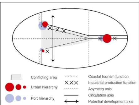
3.3 Synthesis and concluding remarks
The absence of regional integration in Normandy and central southern England has clearly motivated the establishment of two urban networking strategies, with specific goals coming from their specific context.
The spatial analysis based on chorems, and synthesized in Figure 5, shows to what extent the lack of integration has been favorable in the English case and harmful in the French case.
Benefiting from a north-south pattern across administrative divisions, South Coast Metropole is able to promote a sub-regional integrated area based on common interests. Divided by an east-west economic and administrative disrupt, Normandie Métropole remains polarized by Paris and unable to profit from the advantages of decentralization.
Figure 5: Synthesis
However, in the long-run, South Coast Metropole may find harder to attract additional funds from European Commission, its main financial source, with the recent inclusion of East European countries where regional support is of higher necessity. On the other side, the low recognition of Normandie Métropole by foreign investors may turn into an advantage given the unprecedented high rental costs of Paris for office spaces. It will
depend on the partners involved to promote the development of a shared international airport between the three cities (e.g. Deauville project) and the recent logistic park located under the Normandy Bridge, connecting Normandy to the rest of Europe.
Beyond the particular issue of urban networking and the cases introduced, this paper argues that the level of local and regional autonomy is not a positive factor for shaping regional integration, notably in a context of globalization.
References
Allen J., Massey D., Cochrane A. (1998) Rethinking the region, Routledge.
Bournemouth University (1997) The Case for a Central Southern Region, Main Report, March, 30 p.
Brocard M. (1992) “Table de chorèmes”. Washington.
Brocard M. (1994) “Deux villes frontières portuaires : Le Havre et Southampton”. La Revue
d’Ici, n° 11, pp. 8-12.
Brocard M. (2000) “La perception des identités urbaines”. Etudes Normandes, n° 3.
Brocard M., Lecoquierre B., Mallet P. (1995) “Le chorotype de l‟estuaire européen”.
Mappemonde, n° 3, p. 6.
Brunet R. (1980) “La composition des modèles dans l‟analyse spatiale”. L'Espace
Géographique, n°4, pp 253-264.
Brunet R. (1991) Géographie Universelle, tome I : Mondes Nouveaux, 1ere partie : Le déchiffrement du monde. Hachette-Reclus, Paris, pp. 9-271.
Brunet R. (1996) “L‟Europe des réseaux”, in: Pumain D. and St. Julien T. (Eds.) Urban
networks in Europe, Paris, John Libbey.
Brunet R. (1997) Territoires de France et d’Europe – Raisons de géographe, coll. Mappemonde, Belin.
Camagni R. (1993) “Organisation économique et réseaux de villes” In: Sallez (Ed) Les villes, lieux d‟Europe, Paris: DATAR / l‟Aube, pp. 107-128.
Charlesworth J., Cochrane A. (1994) “Tales of the suburbs : the local politics of growth in the South-East of England”, Urban Studies, vol. 31, n° 10, pp. 1723-1738.
Cheylan J.-P., Deffontaines J.-P., Lardon S., Théry H. (1990) “Les chorèmes : un outil pour l‟étude de l‟activité agricole dans l‟espace rural ?”. Mappemonde, n° 4, pp. 2-4.
Church A., Reid P. (1995) “Transfrontier co-operation, spatial development strategies and the emergence of a new scale of regulation : the Anglo-French border”. Regional Studies, vol. 29-3, pp. 297-316.
Clary D. (1987) La Normandie, Que sais-je, PUF.
Clout H. (1994) “L'amenagement du Territoire en France, vu d'outre-Manche”, L'Espace
D.A.T.A.R. (1991) En Europe, des villes en réseaux. La Documentation Française.
Ducruet C. (1999) Urban networking and regional identity, a comparison of Normandie
Métropole and South Coast Metropole Partnership. Undergraduate Dissertation in Territorial
Management, Le Havre University, France, 99 p.
Ducruet C. (2005) “Spatial Structures and Trends in Port Cities: from the Local to the Global”. M@ppemonde, vol. 76, n° 1. http://mappemonde. mgm.fr/num5/articles/ art05106.html
Ducruet C., Jeong O. (2005) European port-city interface and its Asian application. Korea Research Institute for Human Settlements, Research Report 17.
Eliot E. (2003) “Chorotype de la métropole portuaire d'Asie du Sud”. Mappemonde, n° 1, pp. 7-10.
Fabre J. (1991) Les Villes françaises de dimension européenne et les réseaux de villes, Rapport au Conseil Economique et Social, J.O. du 18 mars.
Fontanabona J. (1994) “Ebauche d‟une grille de concepts spatiaux utilisables lors de l‟analyse et de la construction de cartes”. Mappemonde, n° 1, pp. 1-5.
Frémont A. (1977) Atlas et géographie de la Normandie, Portrait de la France moderne, Flammarion.
Eckert D. (1995) “Deux Normandies, un modèle”. Mappemonde, n° 2, pp. 36-39. http://www.mgm.fr/ PUB/Mappemonde/M295/NORMANDIE.pdf
Fabre J. (1991) Les villes françaises de dimension européenne et les réseaux de villes. Report to the Economic and Social Council, J.O., March 18th.
Fujita M., Krugman P., Venables A.J. (1999) The spatial economy: cities, regions and
international trade. MIT Press, Cambridge, London, 367 p.
Hau-Rouchard M.-F., Royoux D., Tesson F., Thoviste L. (1996) “La Politique des réseaux de villes de la DATAR”, in: Pumain D., Godard F. (Eds.) Données Urbaines, Paris : Anthropos, PIR, collection “Villes”, pp. 333-340.
Le Berre M. (1992) “Territoire” in: Bailly A., Pumain D. (Eds.) Encyclopédie de la
Géographie, Paris: Economica.
Loew-Turbout (2000) “South Coast Métropole: une démographie sous influence économique”, Atlas Transmanche. http://atlas-transmanche.certic.unicaen.fr
Mangin Cl. (2001) “D‟Angelinopolis à postmetropolis, ou l‟exception devenant paradigme : un modèle pour la ville mondiale ?”. Mappemonde, n° 1, pp. 5-8.
Mason C., Pinch S. and Witt S. (1990) “Flexible employment strategies in British industry : evidence from the UK Sunbelt”. Regional Studies, vol. 25, n° 3, pp. 207-218.
May N. (1993) “L'aménagement du territoire et le système national urbain : de l'armature urbaine aux réseaux de villes. Questions pour la recherche et l'action”. Revue d'Economie
Régionale et Urbaine, n° 5, pp. 823-832.
Monkhouse J.-F. (1964) A survey of Southampton and its region, Southampton University Press, Southampton.
Offner J.-M. and Pumain D. (1996) Réseaux et territoires – Significations croisées. Paris : L‟Aube / Territoire.
Reffay A. (1979) Le Royaume-Uni et la République d’Irlande, coll. Géographie des Etats, Masson.
Tillard S. (1998) “Caen-Rouen-Le Havre : une dépendance par rapport aux groupes industriels”. Etudes Normandes, n° 3, pp. 55-64.
Unal M. (1998) Mission d’évaluation de la procédure réseaux de villes. 3 vol., DATAR – Confidential Report.