AND TRACE ELEMENT COMPOSITIONS
by
Brian J. Fryer
B.Sc., McMaster University (1968)
SUBMITTED IN PARTIAL FULFILLMENT OF THE REQUIREMENTS FOR THE DEGREE OF DOCTOR OF PHILOSOPHY
at the
Massachusetts Institute of Technology August, 1971 / Signature of Author ./)
-
.
.
. / Certified by . V /11 Accepted by Thesis SupervisorChairman, Departmental Committee on Graduate Studies
Lindgren
MIAT
IAR S
1,
-ii.
CANADIAN PRECAMBRIAN IRON-FORMATIONS: AGES AND TRACE ELEMENT COMPOSITIONS
Brian Jackson Fryer
Proterozoic mio- and eugeosynclinal rocks surround the Supe-rior Province of Quebec and adjoining Labrador on all sides. They unconformably overlie an Archean basement complex and mark the boundary of the Superior and Churchill Provinces of the Ca-nadian Shield on the west, north and east.
Rb-Sr whole-rock isochron studies on volcanic and sedimentary rocks from the Belcher Fold Belt in Hudson Bay, and sedimentary rocks from the Labrador Trough and the Lake Mistassini area of Quebec yield ages of 1800, 1870, and 1790 m.y., respectively. These determinations substantiate previous correlations between
these areas based on stratigraphic and structural similarities. Consequently, the concept of a Circum-Ungava Geosyncline appears
to be valid on geochronological grounds. Geosynclinal develop-ment appears to have been terminated by the onset of the
Hudson-ian orogeny at about 1800 m.y., since part of the succession dated in the Belcher Fold Belt consists on flysch-type sediments overlain by continental deposits. This probably indicates that
sedimentation and uplift were occurring in the miogeosyncline in response to eugeosynclinal deformation to the east.
Trace element studies on three Algoma-type iron-formations in the Canadian Shield reveal anomalous europium enrichments. The possible sources of this are discussed and it is tentatively
in-terpreted that the europium anomalies are the result of normal marine chemical precipitation under the anoxygenous conditions existing in the Archean atmosphere. Rare earth patterns of
iron-formation samples from the Timagami and Michipicoten areas indi-cate that carbonate complexing caused enrichment in the heavy rare earths. The trace element abundances of these Algoma-type iron-formations are remarkably similar to those of the younger Superior-type Sokoman iron-formation and are unlike those of modern sediments associated with volcanic activity.
Consequent-ly, Algoma-type iron-formations are probably not derived from volcanic emanations, as previously thought.
Trace element data from the Sokoman iron-formation of the Labrador Trough suggest that the elements studied were adsorbed onto hydrated ferric oxide in the oxide facies and incorporated into crystallizing iron silicate and iron carbonate minerals in the silicate-carbonate facies. The rocks indicate, both textur-ally and geochemictextur-ally, that they have undergone varying amounts of change during diagenesis. Unlike the Algoma-type iron-forma-tions, Eu behaves normally in this younger iron-formation, but there is some evidence for anomalous Ce behavior.
Textural, trace element, geological and geochronological data on the Sokoman iron-formation indicate that it was deposited
dur-ing the period when oxygen was first introduced into the atmos-phere by biological activity. It is suggested that the Sokoman and Lake Superior banded cherty iron-formations are atypical and represent the products of the termination of banded iron-formation deposition. The Australian, Hamersley and South African Transvaal deposits are believed to be more normal and were produced by
bio-logical and inorganic activity under an anoxygenous atmosphere, probably rich in carbon dioxide.
Thesis Supervisor: Patrick M. Hurley, Professor of Geology
iv. TABLE OF CONTENTS Page Title Page i Abstract ii Table of Contents iv
AGE DETERMINATIONS AND CORRELATIONS IN THE 1 CIRCUM-UNGAVA GEOSYNCLINE
Introduction 2
Analytical Procedures 5
Age of the Upper Volcanics, Belcher Islands 6 Age of the Sokoman iron-formation, central 14
Labrador Trough
Age of the Mistassini Group, Lake Mistassini 22 Area, Quebec
Discussion and Implications 27
References 37
AGE AND TRACE ELEMENT COMPOSITIONS OF ALGOMA TYPE 40 IRON-FORMATIONS OF THE CANADIAN SHIELD
Introduction 40
General Geology and Rb-Sr whole-rock.ages 42
Algoma-type iron-formation, Timagami, 42
Ontario
Michipicoten iron-formations, Ontario 50
Mary River Area, Baffin Island 52
Trace element results and discussion 57
Europium 66
Rare earth patterns and abundances 72
Other trace elements 75
Conclusions 76
Page
References 78
TRACE ELEMENT COMPOSITION OF THE SOKOMAN IRON- 84 FORMATION, LABRADOR TROUGH
Introduction 84
General geology 85
Sokoman Formation 87
Petrography of the Sokoman iron-formation 95
Experimental results and discussion 103
Origin of the Sokoman iron-formation 125
References 141
APPENDIX I: NEUTRON ACTIVATION ANALYSIS 146
A. General 146
B. Preparation of samples for irradiation 146
C. Estimation of errors 149
D. Reagent blank 152
E. Details of analyses 153
F. Comments on sediment analyses 156
References 158
APPENDIX II: SAMPLE DESCRIPTIONS AND LOCATIONS 159 A. Sedimentary and volcanic samples 159
B. Iron-formation samples 159
Acknowledgments 173
AGE DETERMINATIONS AND CORRELATIONS IN THE CIRCUM-UNGAVA GEOSYNCLINE
A striking aspect of the Precambrian of Quebec and adjoining Labrador is the ring of Aphebian sedimentary and volcanic rocks surrounding the Superior Province (Fig. 1). Erosional remnants of the Circum-Ungava Geosyncline in the Belcher Fold Belt, the Cape Smith Belt and the Labrador Trough encircle the Archean gneisses of the Ungava Craton on the west, north, and east, re-spectively (Dimroth et al. 1970).
To the south the Superior Province is truncated by the Gren-ville Province. Recognizable Aphebian strata, however, are
found for some 400 miles south-southwest along the Grenville-Superior boundary from where the Labrador Trough passes into the Grenville. Metamorphosed equivalents of the Trough strata extend 200 miles along the boundary before the last recognizable remnants disappear. Only a few miles north of their termination is the northeast boundary of the Otish Mountains Group. The Otish Mountains Group and similar appearing rocks of the Mis-tassini Group extend another 200 miles to the southwest before ending at the western end of Lake Mistassini.
Previous efforts toward the correlation of these geosynclinal rocks include those of Wahl (1953), Bergeron (1957a,b) and Dim-roth et al. (1970). Wahl (1953) was the first to correlate the rocks of the Belcher Fold Belt, Labrador Trough, and Mistassini on the basis of their simi&&r stratigraphy, lithology and geo-logic history. Bergeron (1957b) essentially agreed with Wahl's interpretation and stated that the lithological similarities and essential continuity of outcrop of the Belcher Fold Belt,
FIGURE 1.
PROTEROZIC SEDIMENTARY AND
VOLCANIC ROCKS
SPROTEROZIC SEDIMENTARY AND VOLCANIC
ROCKS METAMORPHOSED DURING THE
GRENVILLE OROGENY i---J Lu 0 UNGAVA CRATON OTISH MOUNTAI
0
100 0 100 200MILES 100 0 100 300 KILOMETERSwere deposited in a continuous geosyncline (1957a). This geo-synclinal interpretation has recently been accepted and ampli-fied by Dimroth et al. (1970) who synthesized the available data and suggested that the Belcher Fold Belt, Cape Smith Belt and Labrador Trough are the preserved erosional remnants of the Circum-Ungava geosyncline.
Age determinations on these rocks had been limited for the most part to K-Ar ages on the granitic basement which these strata unconformably overlie, and on the weakly to more
strong-ly metamorphosed geosynclinal rocks themselves. K-Ar ages de-termined on the Belcher Fold Belt (Hofman and Jackson 1969) have a mean age of approximately 1650 m.y. reflecting the low grade metamorphism developed during the Hudsonian deformation. These rocks are known to unconformably overlie basement gneiss-es in the Richmond Gulf area that give Archean aggneiss-es (Wanlgneiss-ess
et al. 1968). Thus the rocks of the Belcher Fold Belt must have been deposited between 2500 m.y. and 1650 m.y. The work of Beall et al. (1963) has established a similar situation in the Labrador Trough, although rocks giving K-Ar ages up to 2060 m.y. have been found within the Trough strata. These older ages were interpreted as relicts and thus seemingly put a mi-nimum limit of 2060 m.y. on the deposition of the Labrador Trough. Quirke et al. (1960) reported several K-Ar ages for rocks from the Mistassini area but these appear to have been partially reset by the Grenville and/or Hudsonian orogenies as
gneisses and sedimentary rocks, respectively.
Thus, in summary, the correlations between these rocks have been based on similar lithologies, geologic histories and con-tinuity around the Ungava craton, and age measurements only bracket their deposition within very broad limits.
The present study was undertaken to determine the absolute age of the Circum-Ungava Geosyncline and to attempt to corre-late the Mistassini Group with the Circum-Ungava rocks by ra-diometric dating. It was also of interest to obtain a more accurate estimate of the age of the Superior Type iron-forma-tions found within the Circum-Ungava and Mistassini strata for future global correlations with similar deposits elsewhere. These have been related to possible changes in the rate of production of oxygen by organisms and thus to the emergence of oxygen in the atmosphere (Cloud 1968). The Rb-Sr whole-rock isochron method was used to avoid the effect of minor metamor-phism that had reset previous K-Ar determinations on the Bel-cher, Labrador Trough, and Mistassini rocks.
Analytical Procedures
The chemical preparations and analytical techniques used in this study are those currently in use at the M.I.T. Geochro-nology Laboratory and are given in detail by Reesman (1968). Because the rocks were generally rich in radiogenic Sr8 7 the isotopic measurements were made on 6 inch-radius, 60* sector, solid source, single filament Nier-type mass spectrometers.
using Rb8 7 and Sr8 4 enriched spikes. Sr8 7/Sr8 6 ratios were calculated from the spiked analyses and normalized to a Sr8 6/
Sr 8 8 ratio of 0.1194.
Analytical precision has been monitored by frequent analysis of the Eimer and Amend spec-pure SrCO3 standard (Lot #492327). Eighteen normalized Sr8 7/Sr8 6 analyses average 0.7083 ± 0.0009 (20). Recent studies by Spooner (1969) and Gates (1971) aver-age 0.7083 ± 0.0008 and 0.7082 ± 0.0004 for the normalized
Sr8 7/Sr8 6 ratio of the same standard on two of the instruments. Based on these results analyses on the three mass spectrometers are considered to be directly comparable and the error in the
Sr8 7/Sr8 6 ratio is estimated to be ± 0.0010. The uncertainty in the Rb8 7/Sr86 ratio is assumed to be ± 3%.
The best straight line fit and the intercept of the isochrons on the Sr8 7/Sr86 axis have been determined using the
least-squares computer program of York (1966). Ages have been com-puted using the Rb8 7 decay constant of 1.39 x 10⁻¹¹ yr-1 .
Age of the Upper Volcanics, Belcher Islands
The sedimentary and volcanic rocks of the Belcher Islands re-present part of an embayed miogeosynclinal sequence of the
Circum-Ungava Geosyncline (Dimroth et al. 1970). As in the Labrador Trough, basin filling was cyclical but appears to be
in the reverse order. Basin instability and basic volcanism initiated individual cycles rather than terminated them. As
stability gradually returned, the spilitic basalts were fol-lowed by greywackes and argillites which grade into interbed-ded and massive orthoquartzites and dolomites. The detailed
stratigraphy is given in Table I after Jackson (1960, in Dim-roth et al. 1970).
The second depositional cycle ends with the Kipalu Iron For-mation grading upwards into tuffaceous rocks (Hofman and Jack-son 1969) marking the beginning of the last sedimentary cycle. Twelve samples of these upper volcanics of the Flaherty Forma-tion and eight samples of slate from the overlying Omarolluk Formation and one argillite from the Flaherty Formation have been analyzed (Table II). One sample from the Laddie Formation which lies considerably below these upper formations has also
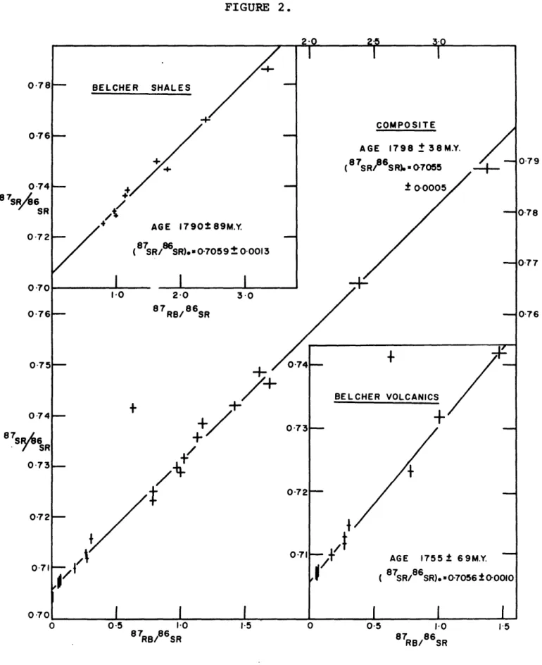
been analyzed. Individual isochrons of the volcanics and slates are presented in Figure 2. The volcanics and slates define isochrons of 1755 ± 69 m.y. and 1790 ± 89 m.y. and ini-tial Sr8 7/Sr8 6 ratios of 0.7056 ± 0.0010 and 0.7059 ± 0.0013, respectively. The composite isochron shows an age of 1798 ±
38 m.y. with initial Sr8 7/Sr8 6 of 0.7055 ± 0.0005. In all cases sample R8043 has been excluded from the computations as it falls considerably outside the limits of experimental error. Sample R8033 has also been excluded as it is known to be stra-tigraphically older than the other samples.
Both the volcanics and the slates appear to be very similar and it is felt that the slates have been formed from basaltic detritus as suggested by Jackson (in Dimroth et al. 1970). The
Table of Formations: Belcher Fold Belt (after Jackson, in Dimroth et al. 1970)
Formation Lithology Thickness
(feet) Loaf Omarolluk Flaherty Kipalu Mukpollo Rowatt Laddie Costello Mavor Tukarak
(Molasse) arkose, quartzite, argillite, conglomerate
(Flysche) greywacke, argillite, lithic and arkosic quartzite, tuff
Basalt, tuff, agglomerate, feldspar porphyry Ferruginous argillites
Quartzite, feldspathic quartzite
Upper: interbedded quartzite and dolomite
Lower: dolomite, arenaceous dolomite
Upper: argillite, quartzite, dolomite
Lower: interbedded argillite, limestone, dolomite
Interbedded limestone, dolomite, argillite, slate, argillite at base
Dolomite with stromatolitic zones
Upper: interbedded argillite, limestone, dolomite
Lower: argillite, dolomite, quartzite
700+ 7000+ 960-6400 200-380+ 130-475+ 620-1000 150-280 660+ 425+ 800-1200 450-550+ 200-230
TABLE I (cont'd.)
Formation Lithology Thickness
McLeary Upper: dolomite with stromatolitic zones
Middle: dolomite with few stromatolitic zones, quartzite 1200-1420
Lower: interbedded dolomite and quartzite
Fairweather Argillite, quartzite, dolomite, tuff, arkose, basalt 1200-2000
Eskimo Basalt, feldspar porphyry, argillite, tuff, agglomerate, (0?)-3000+
granular jasper
Analytical data - Belcher Islands
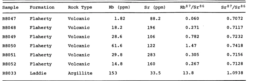
Sample Formation Rock Type Rb (ppm) Sr (ppm) Rb 8 7/Sr 8 6 Sr 8 7/Sr 8 6
Omarolluk Omarolluk Omarol luk Omarolluk Omarolluk Omarolluk Omarolluk Omarolluk Flaherty Flaherty Flaherty Flaherty Flaherty Flaherty Flaherty Slate Slate Slate Slate Slate Slate Slate Slate Argillite Volcanic Volcanic Volcanic Volcanic Volcanic Volcanic R8028 R8029 R8030 R8031 R8032 R8034 R8035 R8036 R8059 R8042 R8043 R8044 R8045 R8046 1 R80462 91.1 129 66.0 66.4 62.9 137 74.8 70.6 77.1 3.64 8.46 12.3 16.2 1.71 0.85 226 158 244 199 166 116 129 128 224 205 40.2 205 45.4 507 37.1 1.17 2.38 0.785 0.967 1.13 3.37 1.69 1.61 0.997 0.0515 0.625 0.173 1.03 0.0098 0.066 0.7384 0.7660 0.7250 0.7298 0.7357 0.7885 0.7462 0.7485 0.7288 0.7070 0.7415 0.7098 0.7317 0.7041 0.7075
TABLE II (cont'd.)
Sample Formation Rock Type Rb (ppm) Sr (ppm) Rb 8 7/Sr 8 6 Sr 8 7/Sr 8 6
R8047 Flaherty Volcanic 1.82 88.2 0.060 0.7072 R8048 Flaherty Volcanic 18.2 196 0.271 0.7117 R8049 Flaherty Volcanic 28.6 106 0.782 0.7232 R8050 Flaherty Volcanic 61.6 122 1.47 0.7418 R8051 Flaherty Volcanic 29.8 283 0.305 0.7156 R8052 Flaherty Volcanic 14.8 160 0.267 0.7128 R8033 Laddie Argillite 153 33.5 13.8 1.0938
FIGURE 2. 0-78- BELCHER SHALES 0-76 O.76 - -0-74 - + 8 SIR
A
AGE 1790t89M.Y. 0.72 (87SR/ SR). 0-7059 0 0013 S70 I I 10 2 0 3 0 0.76 87RB/ 86SR 075 -07 +'/4
0-7 0"71 COMPOSITE AGE 1798 1 38M.Y. (87SR/86S R).07055 ± 0o0005 / BELCHER VOLCANICS+
AGE 1755± 69M.Y. 0 0.5 1.0 15 0 0-5 I.0 1.5 8 7RB/ 8 6 SR 8 RB/ 8 6SR13. that of the volcanics (168 ppm) and the initial Sr8 7/Sr86 of both the slates and the volcanics are indistinguishable within
the limits of experimental error. The higher Rb content of the slates (85 vs 16 ppm) is attributed to the fixation of Rb during the deposition of the slates.
In view of the above factors the volcanic and slate samples are considered to have formed part of the same Sr isotopic system at the time of their c6eposition, and the composite iso-chron is believed to give the best age estimate. As the indi-vidual isochrons are indistinguishable from the composite
within the limits of experimental error, the upper volcanics are considered to have been deposited at 1798 ± 38 m.y. This age is consistent with the suggestion of Hofman and Jackson
(1969) that the major folding of the Belcher Group may have occurred shortly after the deposition of the Loaf Formation which conformably overlies the Omarolluk. According to
Jack-son (in Dimroth et al. 1970) the Omarolluk may represent a flysch-like sequence of turbidite deposits in relatively deep and quiet waters. These grade upward into shallower water de-posits and the conformably overlying Loaf Formation consists of terrestrial conglomeratic and arkosic sandstones possibly representing a terrestrial molasse sequence. These changes are presumably the result of uplift in the miogeosyncline in response to the beginning of Hudsonian deformation in the eu-geosyncline.
Sample R8033 from the Laddie Formation, as well as being stratigraphically older than the other samples, appears to be
derived from a different source. Its high Rb/Sr ratio and low Sr content are unlike those of the other slate samples analyzed and are very similar to those of the Labrador Trough. Its as-sociation with dolomites and quartzite is again similar to the Labrador samples and suggests a continental source rather than a basaltic one. For these reasons this sample was excluded from all computations of age in the Belcher Islands. It is of interest to note that this sample falls on the Attikamagen Slate isochron of the Labrador Trough within the limits of ex-perimental error.
Age of the Sokoman Iron-Formation, Central Labrador Trough Mio- and eugeosynclinal rocks of the Labrador Trough extend over 600 miles from Payne Bay, south-southeasterly, to the Grenville Front at Sawbill Lake. They unconformably overlie Archean gneisses of the Superior Province on the west and re-metamorphosed Archean gneisses on the east (Beall et al. 1963). The detailed stratigraphy of the Labrador Trough has recently been summarized by Dimroth (1968) and Dimroth et al. (1970). Along most of its length it can be divided into an eastern zone of mainly mafic intrusives and extrusives and a western
zone of predominantly sediments. The stratigraphic filling represents two or possibly three tectonic cycles beginning with a sandstone-precipitate sequence and terminating with the deposition of shales in the miogeosyncline and intense volcanic activity in the eugeosyncline. A marginal
unconform-15.
ity separates the first and second cycles and erosional uncon-formities are found within the sequence.
The Sokoman Iron-Formation constitutes the precipitate phase of the second sedimentary cycle and is continuous throughout most of the length of the Labrador Trough. It is the host rock for the residual hematite-goethite ore deposits of the Knob Lake area and its metamorphosed equivalents south of Sawbill Lake constitute the metataconite ores of the Grenville Province. A series of 19 slate samples from formations above and below the Sokoman Iron-Formation have been analyzed from the Knob Lake
area (Table III). The generalized stratigraphy of the sample area is given in Table IV. A composite isochron of all the samples analyzed and individual isochrons of the underlying Attikamagen Slate and the overlying Menihek Slate are shown in
Figure 3. The composite isochron yields an age of 1879 ± 43 m.y. and initial Sr8 7/Sr8 6 of 0.7133 based on a least-squares fit of the data. This value for the initial ratio is not sig-nificant in the age calculation due to the high Sr8 7/Sr8 6 ra-tios of the samples and, owing to the lack of precision in the extrapolation, is not meaningful in the genesis of the sedi-ments.
The Menihek Slate samples define an age of 1855 ± 74 m.y. based on an initial Sr8 7/Sr8 6 ratio of 0.7033 ± 0.0010 deter-mined by least-squares fit. The Attikamagen Slate samples are
too high in Sr8 7/Sr86 and have insufficient spread in Rb/Sr ratios to permit a meaningful estimate of initial Sr8 7/Sr8 6.
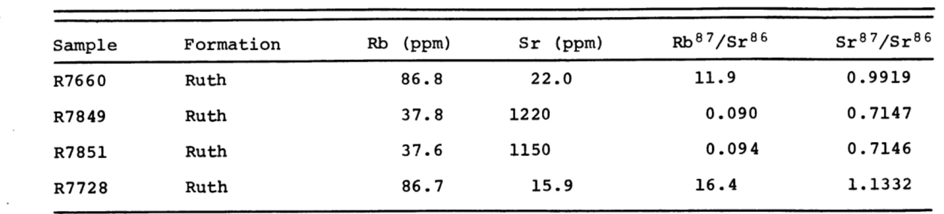
Analytical Data - Knob Lake Area Sample Formation Rb (ppm) Sr (ppm) Rb 8 7/Sr 86 Sr 8 7/Sr 8 6 Menihek Menihek Menihek Menihek Menihek Menihek Menihek Attikamagen Attikamagen Attikamagen Attikamagen Attikamagen Attikamagen Attikamagen Attikamagen R7838 R7839 R7840 R7841 R7623 R7624 R7625 R7627 R7626 R7845 R7846 R7847 R7848 R7943 R7944 156 141 126 163 101 141 143 170 217 191 219 186 244 215 156 40.8 27.7 23.0 32.2 48.7 80.1 63.0 59.5 54.8 54.3 40.5 64.0 55.6 60.9 191 11.4 15.3 16.3 15.7 6.07 5.11 6.66 8.45 11.8 10.5 16.4 8.64 13.1 8.30 2.38 1.0133 1.0879 1.1037 1.1342 0.8606 0.8369 0.8775 0.9628 1.0268 0.9980 1.1485 0.9591 1.0409 0.9497 0.7916
TABLE III (cont'd.) Sample Formation Rb (ppm) Sr (ppm) Rb 8 7/Sr 8 6 Sr 8 7/Sr 8 6 R7660 Ruth 86.8 22.0 11.9 0.9919 R7849 Ruth 37.8 1220 0.090 0.7147 R7851 Ruth 37.6 1150 0.094 0.7146 R7728 Ruth 86.7 15.9 16.4 1.1332
Generalized stratigraphy, Knob Lake Area (after Gross 1968) Formation Menihek Slate Sokoman Iron-Formation Ruth Slate 0 Wishart Quartzite Fleming Chert Denault Dolomite Attikamagen Slate Major Unconformity Ashuanipi
19. FIGURE 3. 10-0 12 0 16 0 MENIHEK SLATE
/
AGE 1855 ±74M.Y. ( 87SR/6SSR).= 0-70 33 00010/
//COMBINED KNOB LAKE SLATES
2 4 6 8 10 12 14 16 18 87RB/86S R AGE 1879 ± 43M.Y. ( 7S8R86SR).- 0-7133 0-0006 40 6"0 80 0 87RB/ 86 RB/ SR ATTIKAMAGEN SLATE
/-REFERENCE ISOCHRON ( 87R/8 SR). 0-710 8 87RB/86, 1I10 1-02 0-9, 18"0 0-94 1-06 1.02 0-98 87SOS /SR 0o821 0"781 0.7 0.7
amounts of carbonate, especially near the gradational contact with the overlying Denault Dolomite. This carbonate appears to have been susceptible to Rb loss during recrystallization. Analyses of twelve dolomite (Table V) samples from the three areas studied bear this out. As all the dolomites were depo-sited at approximately the same time they should have had si-milar initial isotopic compositions. The calculated initial Sr8 7/Sr86 of these dolomites vary from 0.7046 to 0.7192 which is inconsistent with this. It is felt that the spread in cal-culated initial ratios is due to Rb loss from the carbonates during recrystallization and furthermore, that slate samples containing carbonate must be held suspect for the same reason. This loss of Rb is apparent in sample R7944 which is from a
gradational zone between the Attikamagen and Denault formations. It is composed of approximately equal amounts of dolomite and white mica and its high Sr8 7/Sr8 6 ratio suggests that it did not remain a closed system.
The other Attikamagen samples contain little or no carbonate and thus should more nearly approach the closed system require-ments for meaningful age determinations. A 1900 m.y. reference isochron drawn using a geologically reasonable initial ratio of 0.710 (Fig. 3) provides an acceptable fit to the data points excluding R7944. The remaining scatter is somewhat greater than that expected through experimental error alone and is pre-sumably due to minor losses or gains of Rb. This 1900 m.y. age is consistent with both the composite and Menihek Slate iso-chron ages and supports an age of 1870 ± 50 m.y. for the
Soko-TABLE V
Analytical Data - Dolomites
Sample Area Rb (ppm) Sr (ppm) Rb 8 7/Sr 8 6 Sr8 7/Sr86 (Sr 8 7/Sr 8 6) 0 R7500 Knob Lake 1.74 22.0 0.097 0.7123 0.7099 R7842 Knob Lake 2.08 81.'3 0.074 0.7075 0.7056 R7843 Knob Lake 1.64 85.3 0.056 0.7081 0.7067 R7844 Knob Lake 1.87 75.4 0.072 0.7083 0.7065 R8037 Belcher 17.9 116 0.447 0.7282 0.7170 R8038 Belcher 5.1 40.7 0.361 0.7219 0.7129 R8039 Belcher 3.5 37.4 0.271 0.7192 0.7124 R8040 Belcher 25.9 33.3 2.27 0.7760 0.7192 R8009 Mistassini 2.97 60.9 0.141 0.7121 0.7086 R7958 Mistassini 1.46 42.5 0.099 0.7071 0.7046 R7655 Mistassini 2.07 56.1 0.107 0.7175 0.7148 R7656 Mistassini 1.45 54.8 0.077 0.7174 0.7155
man iron-formation.
The whole-rock Rb-Sr age of 1870 m.y. for this section of the Labrador Trough is considerably older than the common Hud-sonian 1600 m.y. K-Ar ages reported by Beall et at. (1963) and Wanless et al. (1968) for the Labrador Trough strata. It pro-bably represents the primary depositional age of these rocks
despite the suggestion by Beall et al. that a 2060 m.y. K-Ar age they obtained puts a minimum limit on the age of the La-brador Trough strata. This old age was found for an argillite with biotite layers located within the biotite-muscovite sub-facies of regional metamorphism developed during the Hudsonian orogeny. Rather than representing a minimum limit for the de-position of the Trough sediments, this rock is probably an isolated case where excess radiogenic Ar4 0 has been incorpora-ted into crystallizing minerals. The low K content of this particular rock would make any excess Ar4 0 much more important
in the calculated age than in more K-rich rocks. Consequently, the second sedimentary cycle of the Labrador Trough appears to have begun at approximately 1870 ± 50 m.y.
Age of the Mistassini Group, Lake Mistassini Area, Quebec The Mistassini group is a succession of little-deformed Pro-terozoic sedimentary rocks unconformably overlying Archean basement in a 100 mile arc around Lake Mistassini.
The regional geology has been treated in detail by Bergeron
(1957a,b) and Quirke et al. (1960) and will only be summarized
23. series of metasediments and volcanics intruded by granite and granite gneiss. This is overlain with profound unconformity by at least 6500' of chemical and clastic sediments of the Mistassini group which have been divided by Bergeron (1957b) into five formations (Table VI). Breaks in the succession such as those in the Upper Albanel formation and at the base of the Temiscamie appear to be disconformities rather than major
breaks.
The strata have a regional strike between 100 and 450 to the northeast and dip to the southeast. Deformation increases to the southeast towards the fault contact with the Grenville gneisses but metamorphism appears to be of exceedingly low grade. Two periods of deformation are observed with northeast
fold and fault systems produced during the Grenville deforma-tion being superimposed upon an earlier period of east and southeast undulations.
Seven samples of the Temiscamie formation have been analyzed for Rb and Sr by isotope dilution (Table VII). They define an
isochron (Fig. 4) of 1787 ± 55 m.y. and an initial Sr 8 7/Sr 8 6 ratio of 0.7015 ± 0.0008. This age is considerably older than the K-Ar age of 1290 m.y. reported by Quirke et at. (1960) for the lower slate of this formation and indeed is older than the K-Ar and Rb-Sr biotite ages of the basement gneisses of 1610 and 1670, respectively. These biotite ages may reflect a pre-vious Hudsonian event possibly related to the earlier period of deformation noted in these rocks, although as only one rock has been analyzed, this is purely speculative. The 1290 m.y.
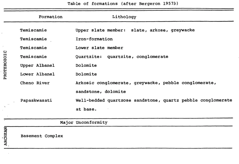
Table of formations (after Bergeron 1957b) Formation Temiscamie Temiscamie Temiscamie Temiscamie Upper Albanel Lower Albanel Cheno River Papaskwasati Lithology
Upper slate member: slate, arkose, greywacke
Iron-formation Lower slate member
Quartzite: quartzite, conglomerate
Dolomite Dolomite
Arkosic conglomerate, greywacke, pebble conglomerate, sandstone, dolomite
Well-bedded quartzose sandstone, quartz pebble conglomerate at base. Major Unconformity S Basement Complex -U u H O frI
TABLE VII
Analytical Data - Temiscamie Formation, Mistassini
Member Quartzite Lower Slate Upper Slate Lower Slate Lower Slate Slate Lower Slate Rb (ppm) 29.5 250 273 199 257 163 149 Sr (ppm) 10.8 30.5 36.1 26.8 38.5 101 175 Rb 7/Sr8 6 8.06 25.2 23.1 22.6 20.3 4.71 2.51 Sr 8 7/Sr 8 6 0.9195 1.3373 1.2616 1.2511 1.2257 0.8106 0.7660 Sample R7957 R8013 R8011 R7956 R7657 R8008 R8012
MISTASSINI ASSOCIATED ROCKS AGE 1787±55M.Y. 87 86 ( SR/ SR) 0-7015 " 0-0008 0 10 87 86 25 RB/ SR 1I40 1I30L-1-20 7 A II10O I'00 0"90 0"80-0 70"80-0
'00"
I
27.
sediment age is probably the result of several different pro-cesses including two periods of deformation, a weak metamor-phism, and probably diffusional losses and at best puts a lower
limit on the deposition of the Mistassini dediments. The Rb-Sr whole-rock age determined here confirms that these K-Ar ages
are survival ages, and the low grade of metamorphism similar to that of the Labrador and Belcher rocks suggests that the age determined may closely approximate the time of deposition.
Discussion and Implications
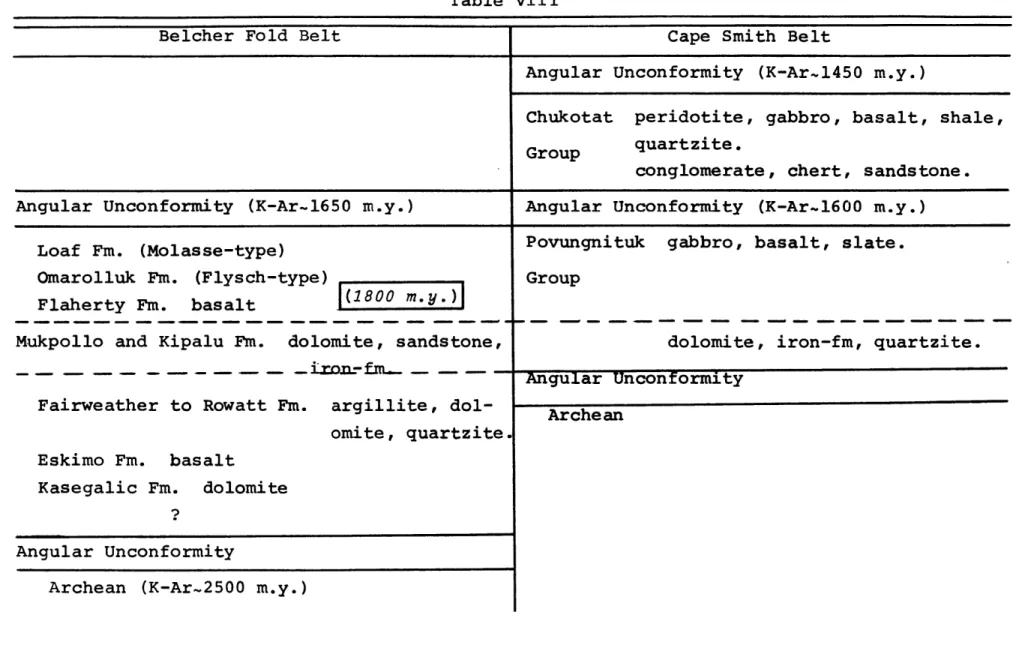
The close agreement obtained between the ages of the Labrador Trough and the Belcher Fold Belt confirms the general correla-tion between these two sedimentary basins. Similarly, the cor-relation of the Cape Smith Belt with these two basins is put on a firmer basis by its position between two isochronous ones. Thus it appears that the concept of the Circum-Ungava Geosyn-cline (Dimroth et at. 1970) is tenable on geochronological as well as stratigraphical and structural grounds.
The 1800 ± 40 m.y. age of the upper volcanics of the Belcher Islands appears to be well established. The good agreement be-tween the shale, volcanic, and composite isochrons and the ge-ological evidence suggesting that the Hudsonian deformation was
underway during deposition of the overlying Omarolluk Formation substantiate this age. In light of the above information, se-dimentation in the Belcher segment of the Circum-Ungava Geosyn-cline must have terminated shortly after 1800 m.y. The Kipalu Iron-Formation which conformably underlies the upper volcanics
cannot be significantly older than 1800 m.y., and hence its age is also established.
Development of the Labrador Trough appears to have been sub-stantially the same as that of the Belcher Belt. The slightly older age obtained for the Sokoman Iron-Formation is consistent with the geological development depicted by Dimroth (in Dimroth
et al. 1970). The Sokoman lies within the second sedimentary cycle of the Labrador Trough (see Table VIII), unlike the dated material from the Belcher Islands which is from near the top of the stratigraphic section. If the difference in age between the two belts is significant, then it is not likely that the Kipalu Iron-Formation of the Belcher Belt correlates with the Sokoman Iron-Formation of the Labrador Trough. If the Kipalu has a correlative in the Trough, then it is more- likely to be
the upper iron-formation of the third sedimentary cycle that is found in the northern parts of the Trough.
Detailed correlations within the two basins must remain spe-culative, but the determined ages suggest that the rocks of the upper cycles may be generally correlatible. Whether or not the two iron-formations of these cycles are equivalent is much more tenuous. If the source of the iron was a deeply weathered landmass, then the proximity of the two basins and their similar source areas would make their correlation more
likely. However, if the source of the iron was volcanic ac-tivity in the eugeosyncline, there is no compelling reason for them to be equivalent.
29.
Labrador and Belcher rocks (Wahl 1953, Bergeron 1957b) appears to be borne out by the 1787 ± 55 m.y. age obtained on the
Temis-camie Formation. This is remarkably close to the 1800 m.y. age of the Belcher upper volcanics. If the onlap of younger forma-tions onto the Superior basement observed both in the Labrador Trough and its southern extension into the Grenville Province
(Jackson, in Dimroth et al. 1970) holds true to the southwest, and the transgressive sequence observed in the Mistassini group indicates that it does, then the Mistassini and Otish Mountains groups may be the youngest rocks of the Southern Province of the Labrador Trough. Through greater onlap these rocks may have escaped being incorporated into the Grenville orogeny and now appear as outliers exposed on the north side of the thrust fault separating the Grenville and Superior Provinces. The low initial ratio of the Mistassini isochron is consistent with this interpretation as it requires a source rdgaon of low Sr8 7/
Sr 8 6 such as would be found in a zone of basic volcanic rocks within a eugeosyncline to the south. If the above interpreta-tion is correct, the Temiscamie Iron-Formainterpreta-tion may correlate in a general way with the Kipalu and upper iron-formation of the Belcher and Labrador basins.
In addition to correlations within the three areas studied, the ages determined have considerable bearing on correlations
and interpretations made on these and other areas of the
Cana-dian Shield. If the Otish Mountains Group is correlative with the Mistassini Group, as is likely (Bergeron 1957b, Young 1970) then the interpretation of Gross (1968) that the rocks of*the
Otish Mountains area may have been derived from a belt uplifted during the Grenville orogeny is invalid. Similarly, the sugges-tion that the Huronian Supergroup may be correlative with the Otish Mountains Group (Frarey and Roscoe 1970) would be unfound-ed as the Huronian sunfound-ediments were depositunfound-ed at approximately
2300 m.y. (Fairbairn et aZ. 1969).
Correlations between the rocks of the Circum-Ungava Geosyn-cline and those of the Animikie basins in the Lake Superior area although not definitely proven are put on a more substan-tial basis with the dates obtained here. The similarity of the age obtained by Peterman (1966) for the Mahnomen Formation
(1.85 b.y.) and the ages of the Circum-Ungava rocks points to their being roughly synchronous. Although Peterman interprets the age of the Mahnomen as a metamorphic age, Faure and Kovack (1969) suggest that it is more likely to be a primary deposi-tional age and the writer is inclined to agree. More work on the Superior rocks will hopefully resolve this problem but the general correlation between the two areas appears to be reason-able in light of present information.
The above correlations are shown in Table VIII. The Lake Superior rocks have been excluded as the great distances sep-arating these areas would make such correlations too tenuous to be meaningful. Hopefully, further radiometric measurements on the Lake Superior sections will make more detailed compari-sons justifiable. The stratigraphic relationships shown are similar to those tentatively suggested by Dimroth (1970, writ-ten communication, 1970) with the addition of the Mistassini
31. and Otish Mountains areas. It must be emphasized that these correlations are approximate and units within compared se-quences probably are not correlatible in many cases.
TABLE VIII
Table VIII
Belcher Fold Belt Cape Smith Belt
Angular Unconformity (K-Ar-1450 m.y.)
Chukotat peridotite, gabbro, basalt, shale,
Group quartzite.
conglomerate, chert, sandstone.
Angular Unconformity (K-Ar-1650 m.y.) Angular Unconformity (K-Ar.1600 m.y.)
Loaf Fm. (Molasse-type)
Omarolluk Fm. (Flysch-type)
Flaherty Fm. basalt I(1800 m.y.)
Mukpollo and Kipalu Fm. dolomite, sandstone,
- _J rof- -fm
-Fairweather to Rowatt Fm. argillite, dol-omite, quartzite.
Eskimo Fm. basalt
Kasegalic Fm. dolomite ?
Angular Unconformity
Archean (K-Ar-2500 m.y.)
Povungnituk gabbro, basalt, slate.
Group
dolomite, iron-fm, quartzite.
Angular Unconformity
Archean
I
Labrador Trough (between 570and 590N.) Labrador Trough (between 570and 590N.)
Angular Unconformity (K-Ar.1610 m.y.) Angular Unconformity (K-Ar.l610 m.y.)
basalt basalt
slate slate
Upper iron-fm. and Abner dolomite Irene Lake iron-fm.
slate, conglomerate slate, basalt.
greywacke.
Fenimore iron-fm. Sokoman iron-fm.I(1870 m.y.)
quartzite quartzite, dolomite.
Angular Unconformity shale, basalt. greywacke.
dolomite, sandstone.
Archean arkose
Angular Unconformity
Table VIII (cont'd)
Southern Labrador Trough (Grenville)
schist Wabush iron-fm. quartzite, marble. schist Angular Unconformity Arche an
Otish Mountain Group
red sandstone, red shale sandstone, conglomerate.
Angular Unconformity Archean
Mistassini
Angular Unconformity (K-Ar..1600 m.y.?) slate
iron-fm., slate, quartzite (1790 m.y.)
dolomite
conglomerate, greywacke, sandstone. quartzite, pebble conglomerate.
Angular Unconformity
37. BEALL, G. H., HURLEY, P. M., FAIRBAIRN, H. W. and PINSON, W. H.,
JR. 1963. Comparison of K-Ar and whole-rock Rb-Sr dating in New Quebec and Labrador. Amer. J. Sci., 261, pp. 571-580.
BERGERON, R. 1957a. Proterozoic rocks of the northern part of the Labrador Geosyncline, the Cape Smith Belt, and the Richmond Gulf area. In: The Proterozoic in Canada (J. E. Gill, ed.), Royal Soc. Can. Spec. Pub.--2, pp. 101-111.
1957b. Late Precambrian rocks of the North Shore of the
St. Lawrence River and of the Mistassini and Otish Moun-tains areas, Quebec. In: The Proterozoic in Canada (J. E. Gill, ed.), Royal Soc. Can. Spec. Pub. 2, pp. 124-131.
CLOUD, P. 1968. Atmospheric and hydrospheric evolution on the primitive earth. Science, 160, pp. 729-736.
DIMROTH, E. 1968. The evolution of the central segment of the Labrador Geosyncline, Part I: Stratigraphy, facies and paleogeography. Neues Jahrb. Geol. u Paliont. Abh., 132, pp. 22-54.
1970. Evolution of the Labrador Geosyncline. Bull.
Geol. Soc. Amer., 81, pp. 2717-2742.
DIMROTH, E., BARAGAR, D.R.A., BERGERON, R., and JACKSON, G. D. 1970. The filling of the Circum-Ungava Geosyncline. In: Basins and Geosynclines of the Canadian Shield (A. E. Baer, ed.), Can. Geol. Surv. Paper 70-40, pp. 45-142.
FAIRBAIRN, H. W., HURLEY, P. M., CARD, K. D., and KNIGHT, C. J. 1969. Correlation of radiometric ages of Nipissing diabase and Huronian metasediments with Proterozoic orogenic events
in Ontario. Can. J. Earth Sci., 6, pp. 489-497.
FAURE, G., and KOVACK, J. 1969. The age of the Gunflint Iron-Formation of the Animikie Series in Ontario, Canada. Bull. Geol. Soc. Amer., 80, pp. 1725-1736.
FRAREY, M. J., and ROSCOE, S. M. 1970. The Huronian Supergroup north of Lake Huron. In: Basins and Geosynclines of the Canadian Shield (A. E. Baer, ed.), Can. Geol. Surv. Paper
70-40, pp. 143-158.
GATES, T. M. 1971. Improved dating of Canadian Precambrian dikes and a revised polar wandering curve. Unpublished Ph.D. Thesis, Mass. Inst. of Tech., Cambridge, Mass. GROSS, G. A. 1968. Geology of iron deposits in Canada, Vol.
III. Iron ranges of the Labrador Geosyncline. Can. Geol. Surv. Econ. Geol. Rept. 22, 179 pp.
HOFMAN, H. J., and JACKSON, G. D. 1969. Precambrian (Aphebian) microfossils from Belcher Islands, Hudson Bay. Can. J. Earth Sci., 6, pp. 1137-1144.
PETERMAN, Z. E. 1966. Rb-Sr dating of middle Precambrian meta-sedimentary rocks of Minnesota. Bull. Geol. Soc. Amer., 77, pp. 1031-1044.
QUIRKE, T. T., JR., GOLDICH, S. S., and KRUEGER, H. W. 1960. Composition and age of the Temiscamie iron-formation, Mis-tassini Territory, Quebec, Canada. Econ. Geol., 55, pp.
311-326.
REESMAN, R. H. 1968. A rubidium-strontium isotopic investiga-tion of the possibility of dating hydrothermal mineral de-posits. Unpublished Ph.D. Thesis, Mass. Inst. of Tech., Cambridge, Mass.
39. SPOONER, C. M. 1969. Sr8 7/Sr86 initial ratios and whole-rock
ages of pyroxene granulite. Unpublished Ph.D. Thesis, Mass. Inst. of Tech., Cambridge, Mass.
WAHL, W. G. 1953. Temiscamie River area, Mistassini Territory. Quebec Dept. Mines, Geol. Rept. 54, 32 p.
WANLESS, R. K., STEVENS, R. D., LACHANCE, G. R., and EDMONDS, C. M. 1968. Age determinations and geological studies, K-Ar isotopic ages Rept. 8, Can. Geol. Surv. Paper 67-2, Pt. A, 141 p.
YORK, D. 1966. Least-squares fitting of a straight line. Can. J. Phys., 44, pp. 1079-1086.
YOUNG, G. M. 1970. Report on symposium on Precambrian sedimen-tation in the Canadian Shield at Univ. of Western Ont., London, Ont., Canada, April 14 and 15, 1970, Science, 170, pp. 1239-1240.
Age and trace element compositions of Algoma-type iron-formations of the Canadian Shield
Introduction
Nearly all the Archean greenstone belts of metavolcanic and sedimentary rocks in the Canadian Shield contain banded cherty iron-formations as an integral part of the basin filling.
These have been named Algoma-type by Gross (1965) for the wide-spread occurrence, variety of lithological facies and typical depositional environment ehibited in the Algoma District of Ontario.
Algoma-type iron-formations typically consist of alternating bands of ferruginous grey or jasper chert and magnetite and/or hematite. The other iron-formation facies of James (1954) are generally less well developed, although locally, as in the Mi-chipicoten area of Ontario, massive siderite and sulphide beds can form a major part of the iron-formation. There is some evidence (Goodwin 1962; Gross 1965) that the particular facies of iron-formation may vary with the enclosing rock type, but
later studies (Goodwin and Shklanka 1967; Ridler 1970; Goodwin and Ridler 1970) suggest that individual iron facies correspond to basin configuration during deposition. Thus, oxide facies give way to carbonate and finally to sulphide facies rocks with deepening water and the previously noted relationship of
iron-formation facies and rock type may be due only to similar depo-sitional environments and not to some other genetic relation-ship.
41. varying from several hundred feet to inches in thickness.
These lenses are usually only a few miles in length although discontinuous lenses may extend for tens of miles in some belts (Gross 1966). Recent studies on the overall basin geo-metry, stratigraphy and development of certain greenstone belts in Ontario (Goodwin and Shklanka 1967; Ridler 1970; Goodwin and Ridler 1970) show that the iron-formations in these belts are usually restricted to certain stratigraphic positions and form important marker horizons. Thus, although
individual iron-formations may lense out, they may be strati-graphically much more persistent than previously thought.
The depositional environment of Algoma-type iron-formations is eugeosynclinal with associated rocks being typically pil-lowed andesites, tuffs, pyroclastics, rhyolites, greywackes, agglomerates and slates. Tuffs and other fine-grained clastic rocks are commonly found interlayered with the iron-formation and Gross (1965) reports that transitions from cherty iron-for-mation to cherty graphitic and pyritic slate commonly occur along strike. The iron-formations are spatially related to the volcanism and appear to generally follow the cessation of individual volcanic cycles. These cycles begin with widespread quiet effusive mafic to intermediate submarine lavas and termi-nate with more violent domical accumulations of acid lavas and pyroclastics.
The source of iron for these deposits is generally agreed to be of volcanic origin (Goodwin 1962, 1964; Gross 1965; Ridler
basins at the present time by fumarolic and hot spring activi-ty associated with volcanic areas (Zelenov 1958; Butzova 1966) show that a volcanic source of the iron is conceivable. Fur-thermore, the generally high arsenic content of many of these rocks (Gross 1966) and the presence of base metals such as copper in disseminated minerals, support this hypothesis.
Although several of these iron-formations have been studied in detail, there have been almost no trace element analyses reported apart from two spectrographic determinations on sid-erite and banded chert from the Helen Mine at Michipicoten
(Goodwin 1961). To get a better understanding of these impor-tant sources of iron ore, a trace element study was undertaken of three of these Algoma-type iron-formations in the Canadian Shield. In conjunction with the trace element studies, Rb-Sr whole-rock isotopic analyses were made on the two areas not previously reported. These ages are discussed along with the general geology of the three areas prior to the presentation
and interpretation of the trace element data.
General Geology and Rb-Sr whole-rock ages
Algoma-type iron-formation, Timagami, Ontario
Algoma-type iron-formation of the Lake Timagami area of On-tario (see Fig. 5) is part of an inlier of metavolcanics and sediments within younger Archean granitic rocks. This green-stone belt may be part of the "Abitibi Belt" of the Superior Province of the Canadian Shield (Goodwin 1968) and is
Cobalt-43. FIGURE 5. VER AREA HUDSON BAY UNGAVA MICHIPICOTEN IRON RANGES TIMAGAMI 100 0 200 S- MILES 100 0 200 0 -- N KILOMETERS
Group. The detailed geology of the Lake Timagami area is given by Moorehouse (1942) and Simony (1964) and the generalized stra-tigraphy of the area is shown in Table IX.
Iron-formation is found in two discontinuous bands trending approximately east-west. Both are probably part of the same stratigraphic hprizon as there is considerable evidence for a synclinal structure (Moorehouse 1942). None of the bands ex-tend for more than six miles along strike and they appear to be typical of Algoma-type iron-formation as described by Gross
(1965). Varying in thickness from several feet to more than 500 feet, they form tabular, steeply dipping bodies conformable with the rest of the sedimentary and volcanic strata. They are
generally associated with tuffs, agglomerates and slates indica-tive of deposition during a relaindica-tively quiet interval in a pe-riod of dominantly intense vulcanism.
Compositionally, the iron-formation is strongly banded and consists of alternating layers of grey, cherty quartz, jasper, magnetite, sugary white quartzite and occasional tuff. Car-bonate and silicate facies are present to a minor extent, and pyrite is found both in the iron-formation and in the adjacent metasediments and volcanics. The separate bands range from microscopic size up to two or three inches in width, and are often branching or lenticular. Larger scale layering, however, does appear to be quite persistent along strike.
Metamorphic grade in this area reaches the epidote-amphibo-lite facies of regional metamorphism except near igneous in-trusions where localized thermal aureoles occur. The rocks
TABLE IX
Table of formations, Timagami, Ontario (after Moorehouse 1942, and Simony 1964)
LATE MAFIC INTRUSIVE ROCKS
Olivine diabase dikes
o Intrusive Contact
H
"Nipissing" quartz diabase, granophyre
E- Intrusive Contact
COBALT GROUP
Lorrain Formation: feldspathic quartzite, arkose
Gowganda Formation: argillite, slate, greywacke, breccia, conglomerate, quartzite Great Unconformity
LAMPROPHYRE: Amphibolite, carbonate, diorite and greenstone dikes
Intrusive Contact
GRANITE INTRUSIVES: Quartz porphyry, feldspar porphry, felsite dikes and intrusives. Granite, granodiorite, including porphritic types, albite granite,
U granite and aplite dikes.
INTERMEDIATE INTRUSIVES: Diorite, quartz diorite, and sheared equivalents, peridotite, and metadiabase intrusives.
BASIC VOLCANICS: Basic and intermediate lava flows, pillow lavas, amygdular lavas, pyroclastics, tuffs, dioritic and recrystallized rocks, chlorite, carbonate, and hornblende schist.
ACID VOLCANICS: Rhyolite, quartz and feldspar porphry, acid tuffs, agglomerates,
carbonate and sericite schist.
47.
are undoubtedly of Archean aqe as they are overlain with pro-found unconformity by the Huronian Cobalt Group dated at ap-proximately 2300 m.y. (Fairbairn et al. 1969).
In an attempt to make a more accurate estimate of the age of the iron-formation, ten whole-rock Rb-Sr analyses were made on the volcanics associated with the iron-formation and on one greywacke. The results are shown in Fig. 6 and Table X. They define a poor isochron and yield an age of 2221 ± 120 m.y. and initial Sr8 7/Sr86 of 0.7083 ± 0.0017 by the computerized least-squares method of York (1966). This age is conspicuously low for Archean rocks but is consistent with the ages obtained by Fairbairn et al. (1966) on the volcanics at Kirkland Lake im-mediately to the north of this area. Those Keewatin and
Timis-kaming volcanics give whole-rock ages of 2376 ± 40 m.y. and 2368 ± 48 m.y., respectively. They are intruded by the Round Lake pluton which has been dated by the Rb-Sr whole-rock
iso-chron method at 2530 m.y. by Fairbairn et al. (1966) and at 2390 m.y. by Purdy and York (1968). A K-Ar age of 2570 m.y. and a Rb-Sr age of 2550 m.y. for a biotite (Aldrich and We-therill 1960) and another biotite K-Ar age of 2605 m.y. (Low-don et al. 1963) from this pluton appear to establish an age greater than 2500 m.y. The low whole-rock Rb-Sr age determined by Purdy and York (1968) may be due to analytical difficulties because of the small spread in Rb/Sr ratios, or the samples may have been affected by the process which lowered the ages of the volcanics in the area.
TABLE X
Rb-Sr isotopic data, Timagami, Ontario
Sample Rb (ppm) Sr (ppm) Rb8 7/Sr8 6 Sr 8 7/Sr 8 6 241 91.2 585 114 68.6 9.67 17.2 18.3 74.0 8.10 0.0153 1.91 0.406 0.202 7.82 47.6 48.5 37.7 0.074 108 0.7046 0.7646 0.7317 0.7147 0.9462 2.2303 2.1160 1.9005 0.7066 4.1108 R7721 R7719 R7723 R7707 R7718 R7 714 R7722 R7708 R7724 R7713 1.27 60.2 82.0 7.93 181 137 253 214 1.90 226
rl lUk~uj 0
4.5
4"0
3.5
30
87
86
SR87/SR
8 62-5
2-0
1-5
I'0
SE0-5
0
10
20
30
40
50
60
70
80
90
100
87
86
RB
/SR
110
120
of the Superior Province have been affected by isotopic redis-tribution at some time after the Kenoran orogeny (- 2490 m.y., Stockwell 1968) In the Timagami area this may be related to the intense carbonatization, shearing, and sericitization of the volcanics under the village of Timagami reported by Bennet
(1969). Consequently, the primary depositional age of the
iron-formation in the Timagami area is known only to be greater than 2490 m.y.
Michipicoten iron-formations, Ontario
Banded iron-formations, clastic sediments and thick piles of volcanics of the Andesite-Rhyolite Association constitute a
greenstone belt surrounded by younger regional granites in the Michipicoten area of Ontario (Fig. 5). The general geology of the area has most recently been described by Goodwin (1962) and will only be outlined here. Briefly, the volcanics show marked lithological and structural variations over short dis-tances. Volcanic activity appears to have been cyclical with three separate phases, beginning with widespread quiet effusive outpourings of intermediate to basic flows followed by rapid, violent discharge of felsic pyroclastics forming broad domical accumulations. The last stage appears to have been prolonged hot-spring and fumarolic activity with considerable alteration and leaching of the breccia domes. The sedimentary rocks ap-pear to be conformable to the enclosing volcanics and Goodwin (1961) interprets them as being formed as a result of contem-poraneous erosion of subaerially exposed volcanics.
51.
The banded iron-formations are associated with the late stage fumarolic and hot-spring activity and form two mutually grada-tional facies. Iron-formation enclosed in sedimentary rocks form lensy discontinuous bands, typically of interlayered chert, siliceous magnetite and jasper, similar to most Algoma-type
iron-formations elsewhere in the Canadian Shield. Iron-forma-tion associated with volcanic rocks, however, is composed of much thicker members of more homogeneous mineralogy. Uppermost
is a banded chert up to 800 feet thick which is the thickest and most persistant member of the iron-formation. According to Goodwin (1961) this is underlain by a lensy, discontinuous pyrite member followed by a thicker unit composed mainly of siderite, which reaches a thickness of 350 feet at the Helen Mine. This siderite-pyrite-chert type of iron-formation typi-cally overlies andesite-rhyolite pyroclastic and breccia depo-sits which have been intensely altered to depths of several hundred feet and is overlain by the effusive mafic and inter-mediate lavas of the succeeding volcanic cycle.
This greenstone belt has recently been dated by Brooks et
al. (1970) who obtained Rb-Sr whole-rock isochron ages of 2700
± 80 m.y. and 2550 ± 100 m.y. on the Lower and Upper Volcanic Series, respectively. These results may represent the primary age of these rocks as low and high grade metamorphic rocks all fall on the same isochrons and the differing ages obtained for the two series indicate that the dates obtained are not the re-sult of regional metamorphism. Since the Helen Iron Range
overlies the Lower Volcanic Series it is thus reasonably well dated at about 2700 m.y.
Mary River area, Baffin Island
High-grade iron deposits near the north end of Baffin Island were discovered in the Mary River area in 1962 (see Fig. 5). The general geology of the area and deposits have been outlined by Jackson (1966) and Gross (1966). The deposits are found within Algoma-type iron-formation which forms lenticular masses within a metavolcanic and sedimentary sequence. This sequence of acid and basic metavolcanics, metasediments and iron-forma-tion has been infolded and faulted within younger granitic
terrane, forming numerous small belts isolated by erosion. They have been intruded by at least two different granites, the young-est of which was accompanied by widespread granitization and po-tash metasomatism (Jackson 1966) and by basic dikes and serpen-tinized ultrabasic rocks.
The iron-formation is of rather unusual nature. According to Gross (1966) thin layered quartz magnetite and quartz hematite
facies are most common, but silicate facies rocks occur in cer-tain areas. The most distinctive and unique feature of these rocks has been the development of nearly pure beds of magnetite and occasional hematite within the iron-formation. They range in thickness from a few inches to tens of feet and are inter-layered with more typical thin magnetite-quartz beds. The iron deposits themselves are of exceptional ore quality as they ty-pically have less than one percent impurities and occur as
zones of massive magnetite or hematite. They have been formed by leaching and oxidizing of the original iron-formation com-bined with supergene enrichment, followed by burial and
high-53.
grade metamorphism. Gross believes, however, that leaching and enrichment alone could not produce such pure iron oxide and that much of the protore must haire been originally rich in iron. Consequently, only small amounts of impurities would have to be removed from the original beds to form the present ore.
The metamorphic grade appears to be quite high in the sedi-ments and volcanics. According to Jackson (1966) many of the rocks have been regionally metamorphosed to the almandite am-phibolite facies and thermal metamorphism was locally important. The last period of widespread metamorphism appears to have oc-curred during the Hudsonian orogeny as shown by the K-Ar ages
(Table XI) reported by Wanless et al. (1966, 1970). For this reason these rocks have been included in the Churchill Province of the Canadian Shield by Stockwell (1968).
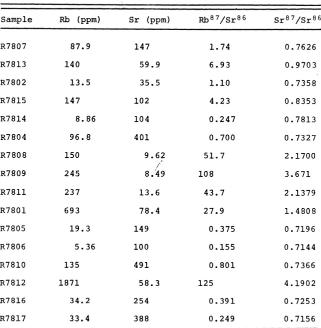
Gross (1966) believes that these rocks are Archean in age and 16 Rb-Sr whole-rock isotopic analyses were undertaken on the metavolcanics and sediments to determine whether this could be substantiated. The analyses are given in Table XII and shown on a Rb-Sr isochron plot (Fig. 7).
The analyzed samples do not define a reasonable isochron due to the complex history of the area. Reference isochrons drawn with a geologically reasonably initial Sr 8 7/Sr 8 6 ratio of 0.710 indicate that the rocks are at least as old as 1950 m.y. and sample R7813 suggests that they may be at least 2650 m.y. The large amount of scatter of the data points is consistent with a primary Archean age for these rocks modified by varying
K-Ar ages Mary River area, Baffin Island (after Wanless et al. 1966,
Rock description
Mica schist
Meta-pyroclastic (?) rock
Gneissic granite
Quartz monzonite pegmatite (cuts iron-formation) Amphibolite sill Meta-orthoquartzite Biotite schist Mineral Muscovite
Biotite (mainly chlorite)
Biotite Muscovite Muscovite Hornblende Muscovite Biotite Age (m.y.) 1750 ± 50 1610 ± 210 1865 ± 60 1655 ± 50 1675 ± 50 1525 1670 1685 55 55 50 1970)
--55.
TABLE XI
Rb-Sr isotopic data, Mary River area, Baffin Island
Sample Rb (ppm) Sr (ppm) Rb 8 7/Sr 8 6 Sr 8 7/Sr 8 6 R7807 R7813 R7802 R7815 R7814 R7804 R7808 R7809 R7811 R7801 R7805 R7806 R7810 R7812 R7816 R7817 87.9 140 13.5 147 8.86 96.8 150 245 237 693 19.3 5.36 135 1871 34.2 33.4 147 59.9 35.5 102 104 401 9.62 8./49 13.6 78.4 149 100 491 58.3 254 388 1.74 6.93 1.10 4.23 0.247 0.700 51.7 108 43.7 27.9 0.375 0.155 0.801 125 0.391 0.249 0.7626 0.9703 0.7358 0.8353 0.7813 0.7327 2.1700 3.671 2.1379 1.4808 0.7196 0.7144 0.7366 4.1902 0.7253 0.7156
87 86 (SR /SR ).- 0-710
3-5
3"0 S R87/SR862*5
-760 20720 1.0 700 0 4-0 2-o L -SEE INSET 0 0 0"5 RB87 S R8657.
amounts of isotopic redistribution during the intense deforma-tion and metamorphism of the Hudsonian orogeny. Thus it appears that the basement at least in this part of Baffin Island is of Archean age, and consequently, the outline of the Archean conti-nent at the time of the Kenoran orogeny must be extended at
least as far as the northern tip of Baffin Island.
Trace element results ard discussion
Analyses for Co, Cr, Sc, Th, As, La, Ce, Nd, Eu, Sm, Ho, Yb, and Lu, have been obtained on ten samples of iron-formation from the three areas by instrumental neutron activation analysis
(I.N.A.A.). The technique used is similar to the one reported by Gordon et at. (1968) with several refinements which are dis-cussed in Appendix 1. The estimated (lo) analytical errors are 10% for Co, Cr, La, Ce, Nd, Sm, Eu, Yb, and Lu, and 20% for Th, Sc, and Ho. The precision and accuracy of the analyses for all elements except Th are believed to be the same as the estimated analytical error. For Th, a high blank value, and extremely low abundance allows only a maximum limit to be placed on its abundance in these rocks. A detailed discussion of the errors and analyses is given in Appendix i.
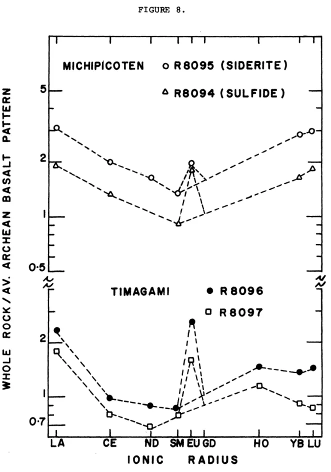
The trace element data are presented in Tables XIII and XIV and the rare earth data are shown graphically in Figs. 8-10. The rare earth data has first been normalized to the average of 9 chondrites reported by Haskin et at. (1968) and then re-normalized to the average chondrite re-normalized pattern (Lu=l) of two Archean basalts from Africa reported by Frey et al.
FIGURE 8.
MICHIPICOTEN
S IR 8095o
R8095
I I(SIDERITE)
z
5
I-I 0Q& R8094
(SULFIDE)
A
"---
4..
A--'-.TIMAGAMI
I
I l 1 IND SM
EU GD
*
R
8096
o R8097
~O~i3HO
1 V~LYB LU
RADIUS
N.--E
L
5i
0"5
0.7
1R
\ \ ILA
CE
IONIC
i~ .... I . A..F
I59. FIGURE 9.
Mary River Area
o R8053
-
MAGNETITE
o R8054
4: 0 -0 R I' / •---"---- \ II /*
R80551
HEMAT
SR8056.
A/A-ITE
R--.-A /
'
--/ / / -II I I IND SMEU
GD
RADIUS
0-5
21: 4 'U 0o o-ex
2L
A,
0-5
LA
CE
IONIC
I 1HO
YB LU
FIGURE 10. Mary River Area
I I I I I I