HAL Id: hal-00299191
https://hal.archives-ouvertes.fr/hal-00299191
Submitted on 4 May 2005
HAL is a multi-disciplinary open access
archive for the deposit and dissemination of
sci-entific research documents, whether they are
pub-lished or not. The documents may come from
teaching and research institutions in France or
abroad, or from public or private research centers.
L’archive ouverte pluridisciplinaire HAL, est
destinée au dépôt et à la diffusion de documents
scientifiques de niveau recherche, publiés ou non,
émanant des établissements d’enseignement et de
recherche français ou étrangers, des laboratoires
publics ou privés.
Economic assessment of landslide risks in the Swabian
Alb, Germany ? research framework and first results of
homeowners’ and experts’ surveys
A. Blöchl, B. Braun
To cite this version:
A. Blöchl, B. Braun. Economic assessment of landslide risks in the Swabian Alb, Germany ? research
framework and first results of homeowners’ and experts’ surveys. Natural Hazards and Earth System
Science, Copernicus Publications on behalf of the European Geosciences Union, 2005, 5 (3),
pp.389-396. �hal-00299191�
Natural Hazards and Earth System Sciences, 5, 389–396, 2005 SRef-ID: 1684-9981/nhess/2005-5-389
European Geosciences Union
© 2005 Author(s). This work is licensed under a Creative Commons License.
Natural Hazards
and Earth
System Sciences
Economic assessment of landslide risks in the Swabian Alb,
Germany – research framework and first results of homeowners’
and experts’ surveys
A. Bl¨ochl and B. Braun
Department of Geography, University of Bamberg, Am Kranen 12, D-96045 Bamberg, Germany
Received: 27 September 2004 – Revised: 12 December 2004 – Accepted: 15 March 2005 – Published: 4 May 2005 Part of Special Issue “Multidisciplinary approaches in natural hazard and risk assessment”
Abstract. Landslide risks are frequently underestimated by political and economic actors as well as by the local popu-lation. The InterRisk Assess research project is working to develop a systematic approach to the analysis and evaluation of economic landslide risks at a local and regional scale. Its major aims are to determine the extent of potential damage and economic losses caused by landslides, to analyze indi-vidual and collective patterns of risk assessment and to de-velop recommendations for pro-active risk management.
The research methodology includes GIS-based risk anal-yses and interviews with relevant actors in politics, admin-istration and planning, private households and land owners. The research findings will facilitate a better-informed, effi-cient and sustainable use of natural resources and natural risks. The research project also aims to contribute to method-ological progress in risk research.
1 Landslides: An underestimated natural risk
Landslides are gravitational mass movements of earth or rock. In the last few decades landslides have caused consid-erable damage (M¨unchener R¨uckversicherung, 2000/2004). Abbott (1996) estimated that US$ 1.5 billion costs are caused by landslides in the United States annually. One example il-lustrating the consequences of landslides is the destruction of the Alaskan Way Viaduct (near Seattle; landslide caused by the Nisqually Earthquake in 2001). The repairs cost some 500 million US$, replacement would have cost US$ 1 bil-lion (Highland, 2003). In Japan, annual losses due to land-slides total about US$ 2 billion. In European countries, an-nual losses can be even higher, for example US$ 2.6 billion per annum in Italy (Schuster, 1996).
Landslides may occur as an isolated phenomenon or in conjunction with volcanic eruptions, earthquakes or floods. Landslides are among the most significant natural hazards Correspondence to: A. Bl¨ochl
(alexander.bloechl@ggeo.uni-bamberg.de)
worldwide. They are integral to numerous geosystems, par-ticularly in alpine regions, but also in many low mountain ranges (Dikau and Glade, 2002).
In German low mountain ranges, landslides occur less frequently and with less dramatic consequences than in the Alps. This results in frequent underestimation of the land-slide risk in these regions, although landland-slides cause dam-age to buildings (in residential areas in most cases), roads, agricultural and forest areas. Smaller landslides occur fre-quently in Rheinhessen, in the region around Bonn and in the Swabian Alb, for example. Other reasons for the un-derestimation of risks are the belief that modern technol-ogy obviates catastrophic consequences for the population, while a lack of knowledge of landslide processes prevents people from seeing any danger in these movements. Thus it is important to analyze landslide risk and its perception and evaluation by the population and key actors in these regions. In order to reduce private and public losses it is necessary to develop methods to evaluate landslide risks in a socio-economic context. This requires an integrative approach ap-plying different scientific and methodological perspectives.
2 Objectives of InterRisk Assess
InterRisk Assess is part of “InterRisk – Integrative landslide risk analysis and risk evaluation in the Swabian Alb (Ger-many)”. InterRisk is a group of four projects initiated in 2003. By integrating physical, social, historical and eco-nomic perspectives InterRisk is working to develop a com-prehensive methodological framework to analyze and evalu-ate landslide risks and to give recommendations to public and private actors. The research framework is applied to land-slide risks in the Swabian Alb in the south-western Germany (federal state of Baden-W¨urttemberg).
Within the InterRisk project group, “InterRisk Assess” (Economic evaluation of natural risks of landslides on the Swabian Alb from a collective and individual point of view) aims to examine economic aspects of landslide risks. The
390 A. Bl¨ochl and B. Braun: Economic assessment of landslide risks in the Swabian Alb, Germany
Fig. 1. Location of the research area.
project combines economic risk analysis and evaluation. It determines regional damage potential and investigates col-lective and individual patterns of risk evaluation. “InterRisk Assess” has four main objectives:
1. To develop methods for the systematic analysis of risks on a regional scale: The estimation of potential dam-age (analysis of elements at risk as well as direct and indirect economic effects) must be linked with the iden-tification of exposure to risk. The economic risk assess-ment is firstly an assessassess-ment of financial risk. It will be integrated in a model of systematic risk evaluation, which includes other factors such as perception, preven-tion or coping capacity (see Objective 2).
2. To develop methods for the systematic evaluation of nat-ural risks: In order to give recommendations to indi-vidual actors and public decision-makers, a widely ac-cepted, standardized methodology has to be developed. Individual and collective risk perception and prevention as well as thresholds of acceptability must be studied. In addition, the costs of prevention measures or alterna-tives should be specified.
3. Search for means of preventing hazards on an individ-ual scale. Analysis of preconditions for actors who take decisions or give recommendations: Actors directly af-fected include private households, farmers, forest own-ers or firms located in landslide-prone areas. An analy-sis of the behavioral patterns of and decisions made by individuals affected or potentially affected is important for optimal adaptation to natural risks and their success-ful prevention.
Fig. 2
Research design one
regional scale: risk analysis and evaluation
information
o former damage events and loss
o analysis of economic values in endangered areas
detailed specification of elements at risk and
possible damages
Research design two
individual/personal scale: risk perception and strategies of prevention selection of persons or groups for detailed interviews evaluation of empirical data
recommendations for risk management on regional, local and individual scale
Fig. 2. Basic conception of the working program of InterRisk As-sess.
4. Recommendations for sustainable risk management at regional, local and individual levels: Landslide risk management is underdeveloped in the Swabian Alb. Therefore it is necessary to develop and apply tools for integrative risk management. Such tools can consist of maps identifying dangers and risks, to be used by plan-ners or administrative authorities. In order to cope with risks one must be familiar with the scale of possible landslide hazards. This task can only be accomplished out in cooperation with the other sub-projects of Inter-Risk.
3 Research area
InterRisk focuses on the northern edge of the Swabian Alb (Fig. 1). There are three reasons for choosing this area:
Firstly, the Swabian Alb is a landslide-prone area with a high incidence of landslides, some of them as extensive as the well-documented landslide at M¨ossingen (Hirschkopf) in 1983 (Bibus, 1986). There has already been remarkable damage to buildings at several locations (e.g. in Lichtenstein, M¨ossingen, Pfullingen, Reutlingen). Early findings of the In-terRisk project indicate that much of this damage has been caused by recent mobilization of fossil landslides (see also Bibus, 1986).
Secondly, the highly urbanized areas of Reutlingen (110 000 inhabitants) and T¨ubingen (85 000 inhabitants) are adjacent to the Swabian Alb and this urbanization puts pres-sure on the valleys and slopes. In the last four decades, many new housing estates have been built on steep slopes and fossil landslides.
Thirdly, the region has been studied extensively by ge-omorphologists and geologists. Thus a fairly comprehen-sive data base on landslide risks, the location of historical landslide events etc. is available (see Bibus, 1998; Terhorst, 1997; Thein, 2000).
A. Bl¨ochl and B. Braun: Economic assessment of landslide risks in the Swabian Alb, Germany 391
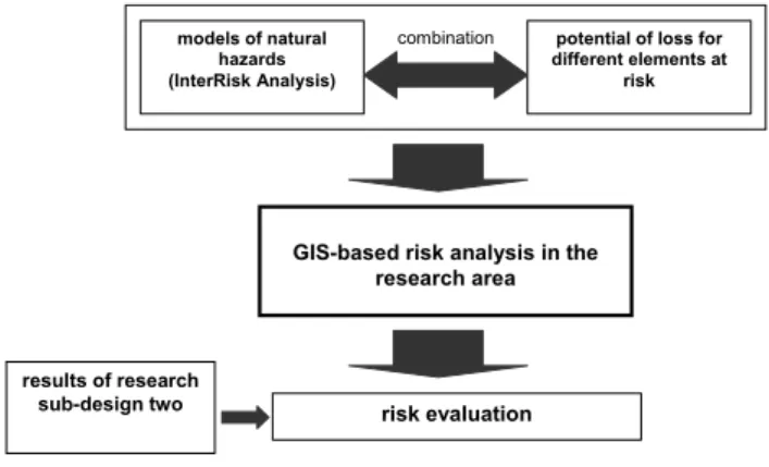
Fig. 3
risk evaluation results of research
sub-design two
GIS-based risk analysis in the research area
models of natural hazards (InterRisk Analysis)
potential of loss for different elements at
risk
combination
Fig. 3. Research sub-design one.
4 Research design
Two research sub-designs form the general structure of In-terRisk Assess (see Fig. 2): “Research design one” analy-ses and evaluates risks at a regional level. “Research design two” investigates risk perception and the vulnerability of ele-ments at risk, and analyses preventive strategies at an individ-ual level. These two research sub-designs are closely related and complementary. The investigation of probable damage is only one step of risk analysis. The analysis of potential haz-ard, which is the other essential step of every risk analysis, is carried out by the InterRisk Analysis project (T. Glade, University of Bonn), which makes its findings available to InterRisk Assess. In research design one we will gather in-formation about previous hazardous events in the region and their consequences for people, organizations, firms or infras-tructures. This data will be collected by analyzing documents and available statistics. In addition, possible economic dam-age will be shown on a map of monetary valuations for en-dangered areas (see Sect. 5). On the basis of this information, persons and organizations will be selected for detailed inter-views in research design two, using standardized interview surveys in different residential areas in the Swabian Alb. The results will be used for a detailed analysis of elements at risk and possible damage.
The findings of both research designs will be used to de-velop recommendations for authorities and individual actors in the region. These must be developed in cooperation with the other projects of InterRisk and local and regional experts. Such recommendations can include the utilization of hazard or risk maps for planning or administration to avoid hous-ing development in endangered areas. The advice for pri-vate house and land owners on “best practices” of prevention, which are identified in research design two, could decrease possible damage to buildings and its cost.
4.1 Research design one: Regional risk analysis and evalu-ation (Fig. 3)
A GIS-based risk analysis will be developed in co-operation with other InterRisk projects. InterRisk Assess contributes
Fig. 4
interviews with private households, firms and land owners in “hazard areas“
• damage caused by landslides
• potential endangered values
• experiences with measures of prevention and security
• individual evaluation of risk by the interviewed persons
interviews with relevant experts in administration, politics, associations, etc.
• complementary information
• collective interests
economic analysis for individual cases
risk evaluation
results of research sub-design one
Fig. 4. Research sub-design two.
a differentiated estimation of financial losses which can be related to natural risk models. A more detailed description will be presented in the following section.
The risk evaluation is based on the economic risk analysis. The evaluation integrates the results of research design two. 4.2 Research design two: Individual risk analysis (Fig. 4) This part of the project consists of interviews with private households, firms and landowners in the study area. Infor-mation will be collected from about 300 private households using questionnaire surveys. The main issues are: damage to buildings caused by landslides, value of land and buildings, experiences with prevention, protection and safety measures, individual risk evaluation by the persons interviewed. More-over, experts in administration, planning, politics, etc. will be interviewed. The expert interviews are intended to further the collection of additional background information and the determination of collective interests.
5 Analysis of potential losses
The methodology for the analysis and evaluation of natural risks has been improved considerably in the last decade (Fell, 2000; Heinimann et al., 1998, Hollenstein, 1997; Melching and Pilon, 1999; Peters Guarin, 2003; WBGU, 1998). Mod-ern approaches are based on the triangle of relations between risk analysis – risk evaluation – risk management (BUWAL, 1999; Hollenstein, 1997; Kienholz, 1998).
Risk analysis focuses on the question “What can hap-pen?”. Risk analysis consists of three steps: the identifi-cation of danger, the analysis of relevant processes and the estimation of potential damage or loss and its consequences (Kienholz, 1994).
Risk evaluation deals with the question “What is allowed to happen?”. The evaluation of risk is a “qualitative or quan-titative characterization of damage in with regard to its like-lihood and extent” (translated from Hollenstein, 1997). The results of risk analyses must be seen in the context of social, economic, cultural, historical and political conditions.
392 A. Bl¨ochl and B. Braun: Economic assessment of landslide risks in the Swabian Alb, Germany
Table 1. Economic values in Lichtenstein-Unterhausen (at a distance of 500 m to the edge of the cuesta scarp). land use area (ha) percentage total land value (EUR) total building value (EUR) forest area 1027.12 77.69 5,135,610
agricultural area 185.51 14,03 3,524,765
residential area 49.15 3.72 122,883,461 264,345,797 mixed use area 12.30 0.93 25,209,858
industrial area 2.54 0.19 1,779,104 other land use 45.43 3.44
total 1322.05 100.0 0 158,532,798 –
Fig. 5. Land-use in Lichtenstein-Unterhausen.
Risk management asks “What has to be done?”. It com-prises all the preventive measures for reducing, controlling and regulating natural risks.
Most approaches in risk analysis and evaluation have a strongly theoretical background. More practical studies can enhance the quality of risk analysis and evaluation. In most instances studies are at a regional or local level (see Hofst-ede and Hamann, 2000; Liebermann and May 2000). One central aim of InterRisk Assess is the development of meth-ods for the systematic analysis of landslide risk at a regional and local scale. It is an attempt to close the gap between the object (landslide) and the regional context. This problem is especially evident in the case of landslide risks which are mostly local and selective.
According to Kienholz (1994), the analysis of potential losses is an integral part of risk analysis. InterRisk Analysis is responsible for the initial steps “identification of danger” and “analysis of relevant processes”. InterRisk Assess car-ries out a financial analysis of potential losses. This is the basis for a model of risk assessment which takes patterns of individual and collective evaluation of landslide hazards into account.
We work on the assumption of an economic worst case scenario. Therefore, the financial risk is the maximum pos-sible loss or damage which can be caused by a natural event. In cooperation with InterRisk Analysis, potential losses and damage will be estimated using GIS. A financial risk map will be created which can be used by administrative authori-ties, planning institutions, engineers or insurance companies. It will show different degrees of risk in combination with cat-egories of potential damage.
The risk map is to be based on a hazard map, which will be provided by InterRisk Analysis. Another important basis for the risk map is a map showing economic values poten-tially affected in the research area (value map), which will be developed by InterRisk Assess.
The value map to be produced by InterRisk Assess will be generated from existing statistical data and findings obtained from the questionnaire survey and the expert interviews. The statistical data available includes land prices provided by the municipalities, real estate prices (comparative price lists for real estate), infrastructure prices as given by supply compa-nies and home contents values (insurance compacompa-nies).
The questionnaire survey and the expert interviews will seek information about the market value of houses, insured values and construction costs. The data helps to relate differ-ent land-use categories (e.g. differdiffer-ent types of residdiffer-ential ar-eas, industrial land, infrastructure) to specific economic val-ues.
The basis for this value map will be provided by local zon-ing plans and development plans which will be linked with statistical data (floor space ratio, standardized construction costs or “Normalherstellungskosten” = NHK) and computed values. For example, Fig. 5 and Table 1 show the economic values of a village in the research area as reflected in the val-ues of different land-use types. At this stage of the study, overall values will be calculated for residential areas only. This approach can be used for other land-use types as well as for analyses at a local level. Since almost all zoning or land-use plans are only available in analogue format, most of the relevant plans have to be digitalized.
The final step in the compilation of an economic risk map involves combining the value map with the hazard map. The compilation of both maps will show zones of landslide haz-ards with specific endangered economic values. If the extent
A. Bl¨ochl and B. Braun: Economic assessment of landslide risks in the Swabian Alb, Germany 393
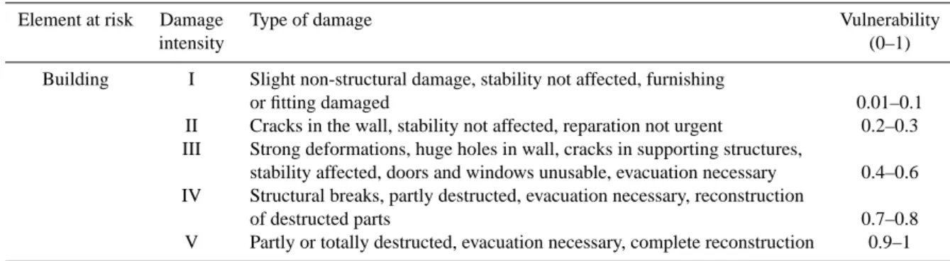
Table 2. Vulnerability of buildings according to the type of damage through landslides (modified after Leone et al., 1996). Element at risk Damage Type of damage Vulnerability
intensity (0–1)
Building I Slight non-structural damage, stability not affected, furnishing
or fitting damaged 0.01–0.1 II Cracks in the wall, stability not affected, reparation not urgent 0.2–0.3 III Strong deformations, huge holes in wall, cracks in supporting structures,
stability affected, doors and windows unusable, evacuation necessary 0.4–0.6 IV Structural breaks, partly destructed, evacuation necessary, reconstruction
of destructed parts 0.7–0.8 V Partly or totally destructed, evacuation necessary, complete reconstruction 0.9–1
of a landslide can be forecasted the immediate material costs incurred in a specific area can be identified.
The method presented here only makes it possible to es-timate the direct material costs of a landslide with regard to real estate. A second step will take account of indirect costs caused by production downtimes or increased storage or transport costs as a result of destroyed or damaged techni-cal infrastructure or factory buildings.
6 The problem of vulnerability
In order to analyze risk the following risk formula can be applied:
R = H × E × V
(R = risk, H = probability of an event in space and time, E = elements at risk, V = vulnerability).
The identification of vulnerability is part of all three steps in risk assessment, and is especially important in risk anal-ysis. From the natural sciences (and engineering sciences) point of view, vulnerability is an important element in the analysis of consequences. It is related to the extent of loss and damage to an element at risk (Glade, 2003).
Several authors have integrated the concept of vulnerabil-ity in landslide risk analyses and assessments (Brabb, 1984; Hearn and Griffith, 2001; Leone et al., 1996; Leroi, 1996; Micheal-Leiba et al., 2000). In the case of landslide risk it is extremely difficult to analyze vulnerability, because land-slide processes are complex and may have very different con-sequences (Leroi, 1996).
However, it is important to integrate the concept of vulner-ability into the risk analysis of InterRisk Assess. The worst case scenario is only one not very realistic possibility in a range of events that could occur. A first step of integrating vulnerability into our research concept would be to establish different categories of damage. In this regard the approach of Leone et al. (1996) is very useful for InterRisk Assess, as the data base for damage caused by landslides in the study area is small. Leone et al. (1996) determine five categories of damage to buildings, ranging from “no structural damage” to “partially or totally destroyed” (see Table 2).
Other perspectives are also important in the project. An-other aim of InterRisk Assess is to integrate social and non-pecuniary aspects into risk assessment. Aspects which influ-ence vulnerability are particularly interesting. For example, knowledge of natural hazards and endangering processes and their perception, or knowledge of and information about pre-ventive measures affect the coping capacity and vulnerability of individuals and society as a whole. Initial work towards the integration of these facets into risk assessment has been carried out in the context of InterRisk Assess. The prelimi-nary findings of this analysis will be presented in the follow-ing section.
7 Preliminary empirical results
A first qualitative survey carried out in March 2004 com-prised 19 households in M¨ossingen- ¨Oschingen (12 km south of T¨ubingen). A more extended questionnaire survey started in September 2004. Up to now, 225 interviews have been conducted with private households. The questionnaire sur-vey focuses on residential areas on slopes in Reutlingen, Lichtenstein-Unterhausen and M¨ossingen- ¨Oschingen.
The study areas were selected using the following cri-teria: Firstly, all areas studied were to be on landslide-prone slopes of the Swabian Alb. The research areas range from the foot of the slope up to the upper limit of set-tlement. Secondly, we selected areas in different spatial contexts: in highly urbanized areas (Reutlingen), in subur-ban areas (Lichtenstein-Unterhausen) and in semi-rural areas (M¨ossingen- ¨Oschingen). In all three areas, the housing stud-ied consists largely of detached single-family residences.
Some buildings already show perceptible damage. Dam-age and losses arising from landslides can include cracks in masonry, damage to the electricity and water supply, subsi-dence or, at worst, the complete collapse of buildings (Fig. 6).
Some tentative results of the household survey are: – The average market value of buildings (including the
price of the land) ranges from EUR 350 000 to EUR 850 000 in the different research areas. Almost all house owners are insured against damage by the elements in-cluding landslides. The costs of reconstruction or repair
394 A. Bl¨ochl and B. Braun: Economic assessment of landslide risks in the Swabian Alb, Germany
Fig. 6. House damaged by a landslide in Reutlingen. The photo-graph shows cracks between the main building and an extension.
are covered by the insurance companies (Finanztest, 2001).
– Landslides are seen as relevant natural hazards by the local population. Figure 7 shows the perceived rele-vance of landslides as a risk for the interviewees’ houses in comparison with other hazards (earthquake, floods, and storms). 42% of the interviewees categorize land-slides as relevant or very relevant for their homes. – Landslide events are well-known, but in most cases
only smaller local events were mentioned by the in-terviewees. The only landslide which was frequently mentioned in all three study areas was the event at M¨ossingen (Hirschkopf) in 1983.
– In 17% of the cases, damage to buildings was observed. About the same percentage of households was also af-fected indirectly by damage to infrastructure.
– Preventive measures were taken by many house owners (39%) with costs ranging from a few hundred Euro to EUR 50 000.
– Perception of landslide risks differs considerably from place to place and from household to household. Land-slide risks are seen as a predominantly small-scale prob-lem by most of the interviewees.
In addition to the questionnaire surveys we conducted 14 semi-structured interviews with local experts from adminis-trative authorities (e.g. municipal administration, road con-struction office), regional planning (e.g. engineers, archi-tects, stress analysts) and the real estate sector in May and July 2004. The main topics were recent experiences with landslides (location of areas, buildings, facilities or persons affected), protection, safety measures and prevention, the re-sponsibilities of different organizations and institutions, risk management and assessment/evaluation patterns from the these experts’ point of view.
Fig. 7 15 9 15 40 110 28 61 63 36 92 70 37 152 57 63 52 0% 10% 20% 30% 40% 50% 60% 70% 80% 90% 100% Storms Floods Earthquakes Landslides
very significant significant less significant not significant
(Source: Household survey September - December 2004, n = 225)
Fig. 7. Significance of selected natural hazards from the perspective of the local population.
Nearly all the experts knew of only a few cases of land-slides. Three groups of experts can be identified:
Firstly, experts for whom landslides are only of minor im-portance. Their portfolio is rarely touched by landslide haz-ards. This group mainly consists of people in administration and real estate agencies.
Secondly, planners, architects and engineers who are well-informed about the problems and processes of landslides. They perceive the risk, but often underrate its dimensions.
The third group comprises people who deal with the prob-lem almost every day. Road construction departments often belong to this group, as the transport system is vulnerable to landslides.
It became clear from the expert interviews that individ-ual cost-benefit analyses with regard to landslides play only a marginal role in decision-making. The only exception is the increase in construction costs due to preventive measures. More important reasons for choosing a house location, how-ever, are the topographic situation, the scenic beauty, the so-cial environment or prestige.
According to the experts, individual voluntary preventive measures are taken by a relatively small number of house owners. They range from planning measures such as geolog-ical engineering consultations to construction works such as walls, reinforced foundations or deeper foundations. The ad-ditional costs can account for up to 20% of total construction costs.
Many people in the research area are insured against damage caused by natural hazards (including landslides), because there was a mandatory insurance for buildings in Baden-W¨urttemberg (“Geb¨audepflichtversicherung”) un-til 1994 which included damage caused by the elements. Since the privatization of this insurance company in mid-1994 this type of insurance is no longer mandatory. However, most house owners have not altered their contracts.
All the experts we interviewed stated that there is no gen-eral risk management with regard to landslide risks. Only a few of them believe that risk management can be established
A. Bl¨ochl and B. Braun: Economic assessment of landslide risks in the Swabian Alb, Germany 395 by politics or administrative authorities. In the experts’
opin-ion, risk management does not exist for the following rea-sons:
– Landslide risks are not perceived as significant dangers or hazards by the administrative authorities and many inhabitants of the region, because events with dramatic consequences are relatively rare.
– The knowledge of natural processes underlying land-slides is rather poor.
– Communication between potential actors in risk man-agement concerning landslide risks is poorly developed or non-existent.
In general, the experts assume that landslide risks do not play a significant role in the choice of construction sites. The only natural hazards that are seriously taken into account are floods and earthquakes. In most of the experts’ opin-ion, people do not perceive landslides as a risk, although the phenomenon “landslide” is well-known in the Swabian Alb. Some people completely deny the existence of land-slide risks, others underestimate it. However, our household survey shows that the view of these experts might be too pessimistic. The explanation for this inconsistency between some experts’ and “ordinary people’s” views will be studied in more detail in the next stage of our project.
8 Conclusions
Landslides are important geomorphological processes in low mountain ranges in Germany. They are especially frequent in the Swabian Alb. However, these processes are not recog-nized as major hazards or risks by the local population and many “experts”. Bearing these facts in mind, one aim of In-terRisk Assess is to strengthen the theoretical base of natural risk research. The economic rational approach is an impor-tant element, but on its own it is not sufficient to explain hu-man behavior with regard to landslides. More sophisticated models have to be developed, revealing the interrelations be-tween public and private actors’ perceptions, behavior and decision-making.
Economic risk assessment is a fundamental part of com-prehensive risk analysis. One function of risk management is to inform people about existing risks, even if the probabil-ity of their occurrence is relatively low.
The main aim of natural risk research is to improve risk management. Risk management is based on improved knowledge of natural and socio-economic interrelations. In-terRisk Assess is working to develop a model of risk evalua-tion and tools for the practical evaluaevalua-tion of economic risk. Acknowledgements. This research project is supported by the
German Research Foundation (Deutsche Forschungsgemeinschaft; DFG).
Edited by: T. Glade
Reviewed by: K. Hollenstein and another referee
References
Abbott, P. L.: Natural disaster, Dubuque, 1996.
Bibus, E.: Die Rutschung am Hirschkopf bei M¨ossingen (Schw¨abische Alb) Geowissenschaftliche Rahmenbedingungen – Geo¨okologische Folgen. Geo¨okodynamik, 7, 333–360, 1986. Bibus, E.: Massenverlagerungen in Baden-W¨urttemberg (Bi
224/10-1 und 2) im Rahmen des MABIS-Forschungsverbundes, T¨ubingen, 1998.
Brabb, E. E.: Innovative approaches to landslide hazard and risk mapping. Proceed, IV Int. Sym. Landslides, Toronto, 1, 307– 324, 1984.
Bundesamt f¨ur Umwelt, Wald und Landschaft: Risikoanalyse bei gravitativen Massenbewegungen, Umweltmaterialien, 107/1, Bern, 1999.
Dikau, R. and Glade, T.: Gefahren und Risiken durch Massenbewe-gungen, Geographische Rundschau, 54, 1, 38–45, 2002. Finanztest: Total abgebrannt, Finanztest, 11, 66–70, 2001. Fell, R.: Landslide risk management, Concepts and guidelines,
Australian Geomechanics Society, Sub-committee on Landslide risk-management, 2000.
Glade, T.: Vulnerability assessment in landslide risk analysis, in: Die Erde, 134, 2, 123–146, 2003.
Hearn, G. J. and Griffiths, J. S.: Landslide hazard mapping and risk assessment, in: Land surface evaluation for engineering practice, Geological society engineering special publication, 18, 43–52, 2001.
Heinimann, H. R., Hollenstein, K., Kienholz, H., Krummen-acher, B., and Mani, P.: Methode zur Analyse und Bewertung von Naturgefahren, Eine risikoorientierte Betrachtungsweise, Umweltmaterialien, 85, BUWAL, Bern, 1998.
Highland, L. M.: An account of preliminary landslide damage and losses resulting from 28 February 2001, Nisqually, Washington, Earthquake, Open-File Report 03-211, U.S. Department of the Interior and U.S. Geological Survey, 2003.
Hofstede, J. and Hamann, M.: Wertermittlung sturmgef¨ahrdeter Gebiete in Schleswig-Holstein, in: Risikomanagement im K¨ustenraum. Beitr¨age zum internationalen Workshop 30./31. M¨arz 2000, Universit¨at Hannover, edited by: Franzius-Institut f¨ur Wasserbau und K¨usteningenieurswesen, 105–112, 2000. Hollenstein, K.: Analyse, Bewertung und Management von
Natur-risiken, Z¨urich, 1997.
Kienholz, H.: Naturgefahren – Naturrisiken im Gebirge, Schweiz-erische Zeitschrift f¨ur Forstwesen, 145, 1–25, 1994.
Kienholz, H.: Naturgefahren und -risiken in Gebirgsr¨aumen, in: Nachhaltigkeit als Leitbild der Umwelt- und Raumentwicklung in Europa, 51, Deutscher Geographentag, edited by: Heinritz, G., Wießner, R., and Winiger, M., Stuttgart, 136–152, 1998. Leone, F., Ast´e, J. P., and Leroi, E.: Vulnerability assessment of
elements exposed to mass movements: working toward a better risk perception, in: Landslides, Glissements de terrain, Proceed. VII Int. Sym. Landslides, Trondheim, edited by: Senneset, K., Rotterdam, 263–270, 1996.
Leroi, E.: Landslides hazard – risk maps at different scales: objec-tives, tools and development, in: Landslides, Glissements de ter-rain, Proceed. VII Int. Sym. Landslides, Trondheim, Rotterdam, edited by: Senneset, K., Rotterdam, 35–51, 1996.
Lieberman von, N. and May, S.: Risikopotenziale f¨ur Nutzfl¨achen und Infrastruktur, in: Risikomanagement im K¨ustenraum, Beitr¨age zum internationalen Workshop 30./31. M¨arz 2000, Uni-versit¨at Hannover, edited by: Franzius-Institut f¨ur Wasserbau und K¨usteningenieurswesen, 97–104, 2000.
396 A. Bl¨ochl and B. Braun: Economic assessment of landslide risks in the Swabian Alb, Germany
Melching, C. S. and Pilon, P. J.: Comprehensive risk assessment for natural hazards. World Meteorological Organization, WMO/TD, 955, Geneva, 1999.
Micheal-Leiba, M., Baynes, F., and Scott, G.: Quantitative land-slide risk assessment of Cairns, Australia, in: Landland-slides: In re-search, theory and practice, Proceed. VIII Int. Sym. Landslides, Cardiff, edited by: Bromhead, E., Dixon, N., and Ibsen, M.-L., London, 1059–1064, 2000.
M¨unchener R¨uckversicherung: Topics 2000: Naturkatastrophen – Stand der Dinge, Special issue, M¨unchen, 2000.
M¨unchener R¨uckversicherung: Topics geo. Jahresr¨uckblick Naturkatastrophen 2003, M¨unchen, 2004.
Peters Guarin, G.: Flood risk assessment for the town of San Sebas-tian in Guatemala, Enschede, 2003.
Schuster, R. L.: Socioeconomic significance of landslides, in: Landslides. Investigation and mitigation, edited by: Turner, A. K. and Schuster, R. L., Washington, D.C., 12–35, 1996.
Terhorst, B.: Formenschatz, Alter und Ursachenkomplexe von Massenverlagerungen an der schw¨abischen Juraschicht-stufe unter besonderer Ber¨ucksichtigung von Boden- und Deckschichtenentwicklung, T¨ubinger Geowissenschaftliche Ar-beiten, Reihe D: Geo¨okologie und Quart¨arforschung, 2, T¨ubingen, 1997.
Thein, S.: Massenverlagerungen an der Schw¨abischen Alb, Statis-tische Vorhersagemodelle und regionale Gef¨ahrdungskarten unter Anwendung eines Geographischen Informationssystems, T¨ubinger Geowissenschaftliche Arbeiten, Reihe D: Geo¨okologie und Quart¨arforschung, 6, T¨ubingen, 2000.
WBGU – Wissenschaftlicher Beirat der Bundesregierung Glob-ale Umweltver¨anderungen: Welt im Wandel, Strategien zur Bew¨altigung globaler Umweltrisiken, Jahresgutachten 1998, Berlin, 1999.