HAL Id: hal-01620618
https://hal.archives-ouvertes.fr/hal-01620618
Submitted on 20 Oct 2017HAL is a multi-disciplinary open access archive for the deposit and dissemination of sci-entific research documents, whether they are pub-lished or not. The documents may come from teaching and research institutions in France or abroad, or from public or private research centers.
L’archive ouverte pluridisciplinaire HAL, est destinée au dépôt et à la diffusion de documents scientifiques de niveau recherche, publiés ou non, émanant des établissements d’enseignement et de recherche français ou étrangers, des laboratoires publics ou privés.
CORALLIGENOUS BOTTOMS: THE INDEX-COR
METHOD
Stéphane Sartoretto, Romain David, D. Aurelle, Anne Chenuil-Maurel,
Dorian Guillemain, Laure Thierry de Ville d’Avray, Jean-Pierre Feral, Melih
Ertan Çinar, Silvija Kipson, Christos Arvanitidis, et al.
To cite this version:
Stéphane Sartoretto, Romain David, D. Aurelle, Anne Chenuil-Maurel, Dorian Guillemain, et al.. AN INTEGRATED APPROACH TO EVALUATE AND MONITOR THE CONSERVATION STATE OF CORALLIGENOUS BOTTOMS: THE INDEX-COR METHOD. Conference: 2nd Mediterranean Symposium on the conservation of Coralligenous & other Calcareous Bio-Concretions, Oct 2014, Por-torož, Slovenia. �10.13140/2.1.3180.6405�. �hal-01620618�
Stéphane SARTORETTO, DAVID R., AURELLE D., CHENUIL A., GUILLEMAIN D., THIERRY DE VILLE D'AVRAY L., FÉRAL J.P., ÇINAR M.E., KIPSON S., ARVANITIDIS C., SCHOHN T., DANIEL B., SAKHER S., GARRABOU J., GATTI G., BALLESTEROS E.
IFREMER, Centre de Méditerranée LER-PAC, Z.P. de Brégaillon C.S. 20330, 83507 La Seyne-sur-mer Cedex, France.
E-mail: stephane.sartoretto@ifremer.fr
AN INTEGRATED APPROACH TO EVALUATE AND MONITOR THE
CONSERVATION STATE OF CORALLIGENOUS BOTTOMS: THE
INDEX-COR METHOD
AbstractCoralligenous outcrops represent a "hotspot" of Mediterranean marine biodiversity. Algae and sessile invertebrate taxa (mainly sponges, cnidarians, bryozoans and tunicates) structure the associated benthic assemblages and constitute remarkable seascapes. Nevertheless, this fragile habitat is submitted to a wide array of human impacts such as sewage outfalls, eutrophication, physical impacts linked to fishing and diving activities, as well as global warming effects. The current European legislative context (EU WFD, EU Habitat Directive, EU MSFD) imposes to reach or maintain a good environmental status for marine ecosystems. In this context, the MPA stakeholders need to have robust and accessible tools allowing the evaluation of the conservation state of the habitats. Concerning coralligenous bottoms, we propose a new method based on an integrated approach taking into account (i) the ratio between sensitive and tolerant species according to human impacts, (ii) the richness of macrotaxonomic descriptors assessed from direct observation (in situ or from images) and (iii) their structural complexity (basal, intermediate and upper layers present in coralligenous bottoms). These three metrics are combined into a global index called INDEX-COR. Datasets were acquired along the French coasts. In each site, 2 transects 15m long were installed on the bottom. Along each transect, 15 photo quadrats (40 cm x 60 cm) and 1 video were recorded and notes were taken by a SCUBA diver-Observer. This method was applied between 15 and 50 meters depth and can be also performed by a ROV (Remotely Operating Vehicule) or an AUV (Autonomous Underwater Vehicle). INDEX-COR is intended to be applied to other Mediterranean areas using metrics and species lists adapted to the different regional contexts.
Key-words: Coralligenous outcrops, conservation index, monitoring, Marine Protected Area
Introduction
There is no real consensus among scientists studying benthic communities in the Mediterranean Sea about what a coralligenous habitat is. Nevertheless, coralligenous concretions area is usually considered to be biogenic formations mainly built by the accumulation of encrusting calcareous algae (Ballesteros, 2006). This bioherm grows in dim light conditions and is very complex in structure, allowing the development of several kinds of communities (Laubier, 1966). Along with the Posidonia oceanica meadows, it represents the main "hotspot" of Mediterranean marine biodiversity (Ballesteros, 2006). This fragile habitat is submitted to a wide array of human impacts such as sewage outfalls, eutrophication, physical impacts linked to fishing and diving activities, as well as Global Change effects (increasing water temperature, acidification, etc). The current European legislative framework (EU WFD, EU Habitat Directive, EU MSFD) imposes the states to reach or maintain a good environmental status for marine ecosystems. In this context, the MPA stakeholders need to have robust, easy-to-use and accessible tools allowing the evaluation of their conservation state (UNEP-MAP-RAC/SPA, 2009). During the last years, some methods based on photographic sampling or direct
observation by SCUBA divers were proposed to evaluate and monitor the coralligenous bottoms. Cecchi and Piazzi (2010) defined an index based on the evaluation of the heterogeneity of assemblages according to the ecological values of the different species (ESCA Index). The Rapid Visual Assessment Method (RVA method) relies on a seascape approach to characterise the ecological quality of coralligenous reefs (Gatti et al., 2012). At last, the Coralligenous Assemblage Index (CAI) is composed by three metrics: (i) the bryozoa percent cover, (ii) the sludge percent cover, (iii) the builder species percent cover(Deter et al., 2012). In order to further contribute to these first studies and methodological recommendations for the characterisation of coralligenous assemblages (Kipson et al., 2011), we hereby present a new method (INDEX-COR method) based on an integrated approach taking into account the impact of human activities on the biodiversity, the composition of benthic assemblages and the 3D structure of coralligenous outcrops (Hong 1983; Gatti et al., 2012).
Materials and methods
Data were collected during two field campaigns carried out in winter of 2013 and 2014. In total, 22 stations were sampled along the coasts of Provence (France) taking into account (i) "natural", (ii) moderate and (iii) highly impacted sites (sewage outfall, industrial activities, fishing, diving) (Fig. 1). Due to the proximity to the Rhône Delta, in the eastern part of the Gulf of Fos coralligenous outcrops develop between 10 and 20 m depth (sites 1 and 2). In the other sites located between Marseilles and St Tropez (sites 3 to 22) data were collected between 30 and 40 m depth.
Fig. 1: Study area and sampling stations. 1: Auguette, 2: Arnette, 3: San Christ, 4: Méjean, 5: Large Niolon, 6: Pointe La Luque, 7: Fromage, 8: Matelot, 9: Ile Plane nord, 10: Ile Plane sud, 11: Moyade, 12: Caramassaigne, 13: Grand Congloue, 14: Sormiou, 15: Morgiou, 16: Devenson,
17: Egoût Figuerolle, 18: Sêche Pêcheur Ouest, 19: Sêche Pêcheur Sud, 20: Sêche Pêcheur Est, 21: Tombant Maconnais, 22: Quairol.
Sampling with the INDEX-COR method is based on the Reef Check Benthos method usually applied to monitor the conservation state of the coral reefs in tropical zone (Hill & Wilkinson, 2004). We also take into account the non-destructive protocol for the biodiversity assessment and monitoring of coralligenous outcrops proposed by Kipson et al. (2011). In each site, sampling by SCUBA diving was performed along two transects (15 m) randomly installed at the same depth and orientation. Along them, 30 photographs (15 per transect) were taken by one diver using a digital camera perpendicularly fixed to a 60x40cm quadrat frame (72000 cm²
in total) (NEX-5 Sony with a 2.8-16 mm zoom-lens Sony used with a housing and a dome NAUTICAM® and four SOLA® 1200 lights). On the same transects, a "diver observer" with an
adapted submersible plate with two lights and a GoPro camera, was in charge of recording: (i) characteristics of the site (depth, orientation, type of slope), (ii) information regarding benthic communities (general development and gorgonians populations) and (iii) species recognizable
in situ without sampling. Considering the constraint of diving (depth and time), below 30m
depth we followed a decompression procedure with oxygen (-6 m).
To evaluate the conservation state of coralligenous outcrops, we selected three metrics: (i) the Ratio between Sensitive and Tolerant Species (RSTS), (ii) the Observable Taxonomic Richness (OTR) and (iii) the Structural Complexity (SC). To assess the RSTS, we analysed photographs taken along transects, using PhotoQuad 1.0 software (Trygonis & Sini, 2012). On calibrated images, uniform 100 sampling points were used. The OTR was determined from the total sessile and vagile benthic taxa (at the genus level minimum) recognizable without sampling. We referred to a list of 160 sessile and patrimonial vagile species (algae, foraminifera, sponges, bryozoans, cnidarians, platelminth, annelid polychaeta, echiurians, mollusca, echinoderms, crustaceans and ascidiaceans). This list was based on those ones established during the MEDCHANGE and EU project CIGESMED (www.cigesmed.eu).
At last, the SC was obtained with 3 sub-metrics: (i) the percentage of species belonging to the basal layer (encrusting species from 0.1 to 5 cm thick), (ii) the number of species belonging to the intermediate layer (5-15 cm) and (iii) the notes of the "diver observer" on the species belonging to the upper layer (>15 cm) with a classification within 5 classes of density. Statistical tests were performed with R Statistical Software (Fox & Andersen, 2005). To define the sensitivity level of species regarding to the organic matter and sediment input, for the first metric (RSTS) we used the delta distribution model modified by Sefánsson (1996). To calculate the third metric (SC), we used a Factor Analysis for Mixed Data (FAMD) (Escofier, 1979; Pagès, 2004). At last, as a first approach, we have chosen an arithmetic mean of the three metrics selected as the INDEX-COR index formula (IC):
IC = (10RSTS+OTR+SC)/3.
Results
For each site, the INDEX-COR method required a dive time of 25 minutes on the bottom and one to two days for data analysis. The application of the modified delta distribution model allowed us to establish a list of 46 species classified in 3 levels of sensitivity according to the level of organic matter and sediment: opportunistic species (Group 1), tolerant species (Group 2) and sensitive species (Group 3). The percentage of each group was calculated from the number of points obtained with the PhotoQuad analysis. To calculate the RSTS value, these percentages were aggregated using a formula based on the Biotic Index defined by Borja et al. (2000) to establish the conservation state of soft bottom benthic communities:
RSTS = (0×%Group 1+5×%Group 2+10×%Group 3)/100 (RSTS values from 0 to 10)
The lowest RSTS values obtained (0.57 to 2.39) corresponded to the stations severely disturbed by the input of sewage outfalls or the Rhône river (Matelot, San Christ, Ile Plane Nord, Fromage, Sêche Pêcheur Ouest, Auguette, Figuerolle). At the opposite, the highest values (4.31 to 5.67) corresponded to the sites least impacted by input of organic matter or sediment (Quairol, Moyade, Devenson, Grand Congloue, Caramassaigne). Concerning the OTR values, they ranged from 18 (Auguette) to 72 species (Sêche Pêcheur Est) according to the general level of anthropogenic impacts estimated by expert judgement (knowledge of local current and human activities in the area). At last, the SC metric was based on the value of the axis I of the
FAMD performed with the classification of the basal, intermediate and upper layers (Fig. 2a). This axis represent 29.9% of the information and is mainly explained by the basal and intermediate layer values as well as the extreme values of the upper layer. In order to embed this value in the INDEX-COR index formula with OTR metrics, it was increased by a factor of 10. Results obtained classify sites according to the general level of pressure, ranging SC values from 0 for Auguette (the most impacted site) to 55.27 for Quairol ("natural" site) (Fig. 2b).
Fig. 2: Classification of sites by the SC value. a: FAMD results. 4 groups of stations can be identified linked to the estimated level of pressure. b: classification of station according to the SC value.
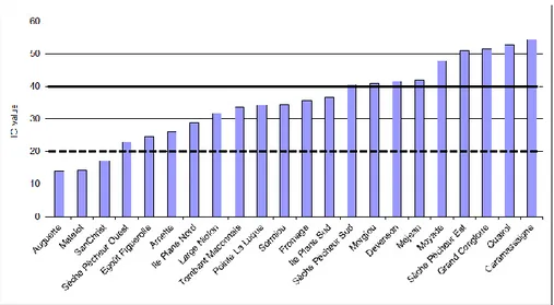
The IC index values ranged from 13.89 (Auguette) to 54.34 (Caramassaigne) (Fig. 3). According to the level of anthropogenic impact evaluated by expert judgement. IC values less than 20 classify stations as highly impacted with a bad conservation state whereas values greater than 40 reflect low impacted station with coralligenous assemblages in a good health.
b
a
Fig. 3: Classification of stations by the INDEX-COR. The dashed bar (IC=20) marks the value boundary for the highly impacted sites and the bold black bar (IC=40) the value boundary for
the low impacted stations.
Discussion
The INDEX-COR method seems to meet the expectations of the stakeholders constraints: rapidity of data acquisition and easy-to-use for analysis, safety diving process and robustness of the index. It can be applied down to 50-60 m depth but an adaptation with ROV (Remotely Operating Vehicule) and AUV (Autonomous Underwater Vehicle) could be considered in deeper zone. The data analysis is not lengthy and does not require specialization in taxonomy knowledge but only the naturalist's experience and a limited training. RSTS, OTR and SC metrics seem to respond well to the level of pressure estimated by the expert judgement. Nevertheless, a more objective anthropogenic impact index is needed to improve this correlation. Unfortunately, the structural complexity of coralligenous outcrops lead to a differentiation of the human impacts at a low scale. The results obtained in the "Sêche des Pêcheurs" site illustrate this fact. Three stations were selected in this site (Sêche des Pêcheur Ouest, Sud and Est) according to their exposure to a sewage outfall. These three stations, less than 200 m away from each other, present different values of the IC index (24.07, 38.51 and 51.60) characterizing a difference in conservation state in coralligenous outcrops. Similar observations can be made for the physical impacts linked to fishing and diving activities (impacts of anchoring and divers). Therefore, a global index specifying the level of impact at low scale (including physical impacts and sediment/organic matter input) is needed to precise its correlation with our three metrics and to precise the best ending formula for the IC index. The next step of work will include a definition of this anthropogenic index and testing of IC index with a more comprehensive set of data (39 other sites have been sampled and will be analysed during next months). At last, this method will be adapted and applied in eastern mediterranean basin (Greece and Turkey) during the EU project CIGESMED.
Acknowledgments
We are grateful to the "Agence des aires marines protégées" for the financial supporting of the INDEX-COR program. We also thank MPA Staffs involved during the field works.
Bibliography
BALLESTEROS E. (2006) - Mediterranean coralligenous assemblages: a synthesis of present knowledge. Oceanogr. Mar. Biol. Annu. Rev., 44: 123-195.
BORJA A., FRANCO J., PÉREZ V. (2000) - A Marine Biotic Index to Establish theEcological Quality of Soft-Bottom Benthos within European Estuarine and Coastal Environments. Mar. Pollut. Bull., 40(12): 1100-1114.
CECCHI E., PIAZZI L. (2010) - A new method for the assessment of the ecological status of Coralligenous assemblages. 46 Congres SIBM form testi v., February 11th 2010.
DETER J., DESCAMPS P., BALLESTA L., BOISSERY P., HOLON, F. (2012) - A preliminary study toward an index based on coralligenous assemblages for the ecological status assessment of Mediterranean French coastal waters. Ecol. Indicators, 20: 345-352.
ESCOFIER B. (1979) - Traitement simultanée de variables quantitatives et qualitatives en analyse factorielles. Cah. Anal. Données, 4(2): 137-146.
FOX J., ANDERSEN R. (2005) - Using the R statistical computing environment to teach social statistics courses. Department of Sociology, Mc Master University: 35pp.
GATTI G., MONTEFALCONE M., ROVERE A., PARRAVICINI V., MORRIA C., ALBERTELLI G., BIANCHI C.N. (2012) - Seafloor integrity down the harbor waterfront: the coralligenous shoals off Vado Ligure (NW Mediterranean). Adv. Oceanogr. Limn., Vol. 3, No. 1, June 2012, 51–67.
HILL J, WILKINSON C (2004) - Methods for ecological monitoring of coral reefs. Australian Institute of Marine Science, Townsville
HONG J.S. (1983) - Impact of the pollution on the benthic community: environmental impact of the pollution on the benthic coralligenous community in the Gulf of Fos, northwestern Mediterranean.
Bull. Korean Fish. Soc., 16, 273–290.
KIPSON S., FOURT M., TEIXIDO N., CEBRIAN E., CASAS E., BALLESTEROS E., ZABALA M., GARRABOU J. (2011) - Rapid Biodiversity Assessment and Monitoring Method for Highly Diverse Benthic Communities: A Case Study of Mediterranean Coralligenous Outcrops. PLoS ONE, 6(11): e27103.
LABOREL J. (1961) - Le concretionnement algal “coralligene” et son importance geomorphologique en Mediterranee. Rec. Trav. Stat. Mar. Endoume, 23 (37), 37–60.
LAUBIER L. (1966) - Le coralligène des Albères: monographie biocénotique. Ann. Inst. Océanog.
Monaco, 43: 139–316.
PAGÈS J. (2004) - Analyse factorielle de données mixtes. Rev. Stat. Appl., 52(4): 93-111.
UNEP-MAP-RAC/SPA (2009) - Actes du 1er symposium méditerranéen sur la conservation du coralligène et autres bioconcrétions calcaires. C. Pergent-Martini, M. Brichets édits., Tabarka, 15-16 Janvier 2009, Tunis: 269pp.
STEFÁNSSON G. (1996) - Analysis of groundfish survey abundance data: combining the GLM and delta approaches. J. Mar. Science, 53: 577–588.
TRYGONIS V., SINI M. (2012) - PhotoQuad: A dedicated seabed image processing software, and a comparative error analysis of four photoquadrat methods. J. Exp. Mar. Biol. Ecol., 424–425: 99–108.