HAL Id: hal-01244258
https://hal.archives-ouvertes.fr/hal-01244258
Submitted on 15 Dec 2015
HAL is a multi-disciplinary open access
archive for the deposit and dissemination of
sci-entific research documents, whether they are
pub-lished or not. The documents may come from
teaching and research institutions in France or
abroad, or from public or private research centers.
L’archive ouverte pluridisciplinaire HAL, est
destinée au dépôt et à la diffusion de documents
scientifiques de niveau recherche, publiés ou non,
émanant des établissements d’enseignement et de
recherche français ou étrangers, des laboratoires
publics ou privés.
I. La Jeunesse, C. Cirelli, H. Sellami, D. Aubin, R. Deidda, N. Baghdadi
To cite this version:
I. La Jeunesse, C. Cirelli, H. Sellami, D. Aubin, R. Deidda, et al.. Is the governance of the Thau
coastal lagoon ready to face climate change impacts?. Ocean and Coastal Management, Elsevier,
2015, 118 (Part B, december), pp.234-246. �10.1016/j.ocecoaman.2015.05.014�. �hal-01244258�
Title
1
Is the governance of the Thau coastal lagoon ready to face climate change impacts? 2
Authors
3
I. La Jeunesse1,2,, C. Cirelli1, H. Sellami3, D. Aubin4, R. Deidda5, 6, N. Baghdadi7
Author affiliations
4
1
Université François Rabelais de Tours, UMR CNRS 7324 Citeres, 33, allée Ferdinand de Lesseps, 5
B.P. 60449, 37204 Tours cedex 3, France 6
2 University of Angers, UMR CNRS 6554 LETG – Angers, 2 bd Lavoisier, 49045 Angers, France
7
3
Université catholique de Louvain, Earth and Life Institute, Croix du sud 2, bte 1, B-1348 Louvain-la-8
Neuve, Belgium 9
4
Université catholique de Louvain, Institut de sciences politiques Louvain-Europe, Place Montesquieu 10
1, bte L2.08.07, B-1348 Louvain-la-Neuve, Belgium 11
5
University of Cagliari, Department of Civil and Environmental Engineering and Architecture, Via 12
Marengo 2, 09123 Cagliari, Italy 13
6
CINFAI, Consorzio Interuniversitario Nazionale per la Fisica delle Atmosfere e delle Idrosfere, 14
Tolentino, Italy 15
7
IRSTEA, UMR TETIS, 500 rue François Breton, 34093 Montpellier cedex 5, France 16
Corresponding author
17
Isabelle La Jeunesse, Université François Rabelais de Tours, UMR CNRS 7324 Citeres, 33, allée 18
Ferdinand de Lesseps, B.P. 60449, 37204 Tours cedex 3, France, isabelle.lajeunesse@univ-tours.fr
19
Abstract
20
The present paper provides a reflection on threats to integrated management of the Thau coastal 21
lagoon due to climate change and the multi-scalar water scarcity adaptation strategy. This study 22
proposes first to depict the Thau water governance assessed through a water use and social network 23
analysis and its capacity to manage water quality. Next, this paper provides a downscaled study on 24
the climate change impacts on the hydrological budget of the entire Thau catchment in 2041-2070 25
research program. Following local climate change impacts, the importation of a new water resource to 27
secure water uses is presented in regards to the capacity of local water governance to maintain 28
coherence between integrated land planning and integrated water management planning based on 29
water quality issues of the Thau coastal lagoon. The study underlines that although the water uses are 30
currently secured thanks to the regional transfer of water, they are not coherent with local water 31
management and create new vulnerabilities in the context of climate change. Moreover, the regional 32
decision to end financial support for the more efficient, existing network for the water quality survey of 33
regional coastal lagoons breaks up the local water governance. This paper demonstrates why keeping 34
this network would have been absolutely necessary for encouraging a governance capable of 35
proposing sustainable solutions to water quality challenges induced by climate change. 36
Keywords
: climate change, integrated coastal management, hydrology, water governance 37Highlights
38
• Climate change will increase temperature and decrease runoff in the Thau catchment 39
• Climate change challenges for local water uses are not perceived by local stakeholders 40
• Regional water management provides security for domestic use including tourism, and irrigation 41
• Regional water management increases the vulnerability of local water governance 42
• CLIMB EU FP7 project, CLIWASEC cluster, multidisciplinary analyses 43
Introduction
44
According to the IPCC climate model projections, Mediterranean countries are at high risk for 45
pronounced susceptibility to changes in temperature in the hydrological budget and in the occurrence 46
and magnitude of extreme conditions (IPCC, 2007; Giorgi and Lionello, 2008). Moreover, the increase 47
in temperature of marine waters and its interaction with acidification may induce an amplification of 48
eutrophication and hypoxia (Bijma et al., 2013). 49
It can be foreseen that the changes in the hydrologic cycle will give rise to an increasing potential for 50
conflicts (Ludwig et al., 2011), or at least rivalries (Bressers and Kuks, 2004; Aubin, 2008; La 51
Jeunesse et al., 2013), and possible tensions among the political and economic actors. To provide 52
expertise and adaptation strategies, multidisciplinary research is needed to tackle the multi-facet 53
complexity of climate change impacts on water resources (Quevauviller et al., 2012) a fortiori in the 54
Mediterranean (Santos et al., 2014). In this context, the cluster of three EU projects CLIWASEC is 55
tackling the ‘climate change – water – security’ nexus. One of those, the CLIMB project, is focusing on 56
inter-linkages and interdisciplinary analyses around the quantification of uncertainties in climate 57
change impact and risk assessment (Ludwig et al., 2010). 58
Several empirical and simulation studies support the idea of increased eutrophication with climate 59
change which contradict the expectations of reductions in nutrient loading from catchments in drier 60
climates and greater stability of the water column in warmer climates (IPCC, 2007). Because of the 61
already high anthropogenic pressures coming from both coastal and continental areas, transitional 62
waters and a fortiori coastal lagoons, as semi-enclosed ponds, are the ecosystems particularly 63
exposed to the impacts of climate change. 64
Following this list of impacts, effective adaptation measures require multi-disciplinary preparation and 65
efficient water governance (Ostrom, 1990). “Governance refers to all processes of governing […], it 66
focuses not only on the State and its institutions but also the creation of rule and order in social
67
practices” (Bevir, 2013). Thus, governance is a mix of procedures (hierarchical, networked, or
market-68
oriented) which involves public and private stakeholders in the management of an issue of public 69
interest. The focus here is on the local networks of public and private water users and managers and 70
the ways these stakeholders manage water-related issues and problems. In particular, transitional 71
waters at the confluence of continental and marine issues are complex ecosystems with important 72
anthropogenic pressures sometimes exacerbated by inappropriate management in diverse chains of 73
cause-effect relationships (Newton et al., 2014). 74
The European Union started to define rules for Integrated Coastal Zone Management (ICZM, Cicin-75
Sain and Knecht, 1998) first through the Water Framework Directive (WFD), which covers the 76
transitional and coastal waters up to 1 nautical mile from the continental baseline. The ICZM has been 77
completed for marine waters by a marine policy initiated in 2008 with its environmental part 78
represented by the Marine Strategy Framework Directive (Borja et al., 2010 ; Elliott, 2013). 79
Nationally, France has a history of using coastal spatial planning instruments with a regulation tool 80
called ‘Schéma de Mise en Valeur de la Mer’ (SMVM). The key features of this marine spatial planning 81
process was based on the cooperation of multiple partners including a development phase in which 82
elected officials and all stakeholders (sector representatives and experts) are involved, with final 83
approval by State representatives. 84
Thau has been a leader in France for ICZM planning with the first implemented SMVM in 1995 85
(Trouillet et al., 2011). In fact, the benefits of maintaining the water quality of the Thau lagoon have 86
been evident since the ecological crisis of the 1970s, when 100% of the Thau lagoon waters suffered 87
from an anoxic crisis due to eutrophication, which destroyed 100% of the shellfish farming stocks. To 88
implement the WFD in transitional waters along the coastline and as stakeholder involvement in water 89
management planning and public consultation has become mandatory for member states, the 90
Languedoc-Roussillon (LR) region initiated in 2000 a new network to address eutrophication for 91
coastal lagoons under the name Lagoon Monitoring Network (LMN). This network, with steering 92
committee composed of five stakeholders of water and marine production management (the LR 93
region, the water agency of the Rhône-Méditerranée-Corse basin, the DREAL as the state 94
representative for environmental management, the Ceprelmar as the regional institute created in 1981 95
for promoting marine production that drives the LMN, and Ifremer as the partner for scientific research 96
expertise), launched two 6-year contracts. The objectives were to build a eutrophication monitoring 97
program of the lagoons of the LR region to deliver an operational Decision Support System (DSS) to 98
local stakeholders to support their decentralized management of the lagoons. 99
In the meantime, the creation through a bottom-up strategy of SAGE-Thau (Schéma d’Aménagement 100
et de Gestion des Eaux as the Thau River Basin Management Plan), driven by a local public body 101
called the SMBT (Syndicat Mixte du Bassin de Thau), which acts on the behalf of the two largest 102
intercommunalities of the Thau lagoon - CABT (Communauté d’Agglomération du Nord du Bassin de 103
Thau) and CCNBT (Communauté des Communes du Nord du Bassin de Thau), has permitted the 104
development of an integrated management of water quality in the Thau lagoon. 105
In fact, it is now well known worldwide and even locally that a common knowledge base between 106
stakeholders, expert and scientists is requisite for implementing more elaborate forms of participation 107
(Loubier et al., 2005; Rinaudo and Garin, 2005). The water quality restoration of the Thau coastal 108
lagoon is the result of twenty years of several multi-disciplinary investigation programs alternately 109
conducted by scientists and the local public bodies (e.g., OxyThau, EcoThau, PNEC, Omega-Thau, 110
SPICOSA and so forth). DSS tools provided by the synthesis of these programs are currently used by 111
the SMBT to produce indicators of water quality vulnerability (Mongruel et al., 2013). Some DSSs on 112
lagoon water quality are provided, such as the one related to eutrophication, O’GAMELAG, or others 113
related more to microbial contamination such as VigiThau. In parallel, other tools under development 114
propose to model how local territories, such as the Thau coastal lagoon, have promoted endogenous 115
development based on Socio-Technical Information and Communication Arrangements at the scale of 116
inter-municipal authorities to support mediation between heterogeneous actors which drives territorial 117
intelligence (Bertacchini et al., 2013; Maurel et al., 2014, Plant et al., 2014). 118
Furthermore, the Thau coastal lagoon has kept its ‘status’ as a pilot site for ICZM through its 119
nomination by the DATAR (Délégation interministérielle à l’Aménagement du Territoire et à 120
l’Attractivité Régionale) interministerial delegation as a pilot site for the implementation of community 121
regulations for ICZM strategies. Thus, in April 2013, an Integrated Management Contract (IMC) was 122
signed for the Thau territory for the period 2012-2017. Its main objective was to provide coordination of 123
all the management tools implemented in the territory including the preservation of Thau coastal 124
lagoon water quality as the support of marine production. 125
Therefore, this paper aims to provide a reflection on climate-induced threats to integrated 126
management of the Thau coastal lagoon and the multi-scalar adaptation strategy. It proposes first to 127
depict the Thau water governance assessed through a water use and social network analysis and its 128
capacity to manage water quality. Then, this paper provides a study of the downscaled climate change 129
impacts on the hydrological budget of the entire Thau catchment in 2041-2070 compared with the 130
1971-2000 reference period. Following local climate change impacts, the importation of new waters to 131
secure water uses is presented in regards to the capacity of local water governance to maintain 132
coherence between integrated land planning and integrated water management planning based on the 133
water quality issues of the Thau coastal lagoon. 134
Material and Methods
135
The Thau catchment – coastal lagoon hydrosystem
136
The coastal lagoon
137
The Thau lagoon is located in the LR region in the Hérault Department in the south of France. It is a 138
75 km² water body 19.5 km long and 4.5 km wide with a mean depth of 4 m and a high variability of 139
salinity. Approximately one fifth of the lagoon’s area (1,500 ha) is farmed for shellfish production, with 140
shellfish farming occurring in three zones on the lagoon (Figure 2). It is also used for fishing. 141
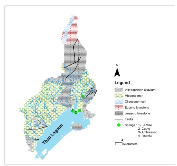
The lagoon is in connection with the Thau karstic system which is made of complex karstic networks of 142
economical role since it supplies water for fish breeding, for the spa in Balaruc-les-Bains, and most 144
importantly, for some local drinking water supply (Pinault et al., 2004). Complex interactions between 145
the lagoon and the karstic system exist. For instance, seawater can occasionally inter the karstic 146
system through the spring conduits (Figure 1), depending on several factors including the hydraulic 147
head in the aquifer and in the Sea, rainfall event and water density in the aquifer (Pinault, 2004). This 148
phenomenon is locally known as inversac, and it can last for several weeks. 149
The frequency of anoxic crises, intensified during the second half of the 20th century (Elbaz-Poulichet 150
et al., 2004), is a consequence of both eutrophication levels (La Jeunesse and Elliott, 2004) and 151
particular meteorological conditions (Chapelle et al., 2000). Depending on the severity of the hypoxia, 152
it can lead to the destruction of shellfish stocks. 153
154
Figure 1: Simplified geological map of the Thau karstic system 155
The catchment area
156
The Thau catchment covers approximately 280 km² (Figure 2). Almost 70% of the land devoted to 157
agriculture is used for vineyards. Approximately half of the area’s permanent population of 115,000 158
inhabitants is located in the city of Sète, situated on the southern shore of the lagoon. The population 159
of the region is continuing to increase, and in summer tourists, mainly linked to the Mediterranean Sea 160
side double the population of the area. A second French spa is located in Balaruc-les-Bains on the 161
Thau coastline. 162
The catchment area is drained by a dozen intermittent small streams that flow directly into the lagoon. 163
The Vène and the Pallas are the two main watersheds of the Thau, and they cover an area of 164
approximately 67 km2 and 54 km2, respectively, representing approximately 54% of the total surface of 165
the Thau watershed and accounting together between 50% to 80% of total freshwater inputs into the 166
lagoon (Plus et al., 2006; Sellami et al., 2013). 167
168
Figure 2: Localization of the Thau coastal lagoon and its catchment in the French Mediterranean coast 169
The local climate
170
The local climatic features were estimated from the historical observations recorded by the Météo-171
France meteorological station of Sète from 1970 to 2010 (Figure 2). This station is considered as 172
representative for the whole catchment. This assumption is justified by the fact that the Thau 173
catchment is rather small and quite flat; thus, it does not display significant spatial variability except for 174
some orographic effects, which can be easily accounted for. The analysis of the 40-year time series in 175
Sète revealed a marked inter-annual variability of the local precipitation climate. Indeed, the annual 176
precipitation depth varies from 290 to 1000 mm, while the average is approximately 600 mm per year. 177
Examining the monthly distribution more closely, precipitation displays a marked seasonal variability: 178
precipitation occurs mainly during autumn and winter with frequent intense storms, whereas a long dry 179
period usually extends from the end of winter to the end of summer, with a minimum in July. The 180
climatic distribution of monthly precipitation has been used to apply the final local-scale bias-correction 181
as described later. The analysis of the temperature time series reveals that the hottest months are July 182
and August and that daily temperature maxima exceeding 35°C are frequently observed, while the 183
coldest months are December and January when daily minimum temperatures can sometimes be 184
lower than -5°C (Sellami et al., 2013). 185
The French water management
186
At the hydrographic district scale, water agencies are responsible for the characterization of water 187
bodies, public consultation, participation of water users in the water management policy, and 188
preparation of the 6-year river basin management plans (called SDAGE) and programs of measures to 189
implement the Water Framework Directive (WFD). 190
At the local level, the decision and implementation of water regulations strictly rely on the departmental 191
prefects, who represent the central government at the administrative level. Then, state management is 192
made through decentralized services: the DREAL (Regional Direction of Environment, Planning and 193
Housing) and the DDTM (Departmental Direction of the Territories and the Sea). 194
At the sub-catchment scale, one of the main water management tools in France is SAGE. It is a 195
planning document that pursues both quantitative and qualitative protection goals for water resources. 196
When SAGE is approved, all decisions concerning water issues in the area must comply with its 197
objectives. This legal status not only concerns the administration but also private individuals. It is 198
developed by local actors (policymakers, users, NGOs, representatives of the state and elected 199
people representing municipalities) together within the Local Water Commission (LWC). LWC has the 200
status of an administrative commission without a legal personality. It organizes and manages the 201
entire process of development, consultation and implementation of SAGE. It is an ideal place for 202
dialogue, debate, advocacy and decision-making. 203
Since the urban planning law (SRU) of 2000, a planning document known as the scheme of territorial 204
coherence, SCoT, has determined at a scale of several municipalities the general guidelines for land 205
planning for the next 10 years. As urban planning and water management have common concerns, 206
SCoT and SAGE require coherent ambitions. On the Thau territory, these two main local public 207
policies instruments are driven by the SMBT. 208
The regional hydraulic management
209
The French use of regional Mediterranean water has through the centuries led to important hydraulic 210
techniques for transferring water from regions with water availability to regions with important water 211
needs that are not sufficiently supported. In this situation, the Rhône River represents the major river 212
of the Mediterranean coast and was obviously the coveted river for pumping and transferring between 213
catchments. A national company for managing the water transfer was created in 1955 by Philippe 214
Lamour under the name CNABRL (Compagnie Nationale d’Aménagement Bas-Rhône-Languedoc). 215
The project is for a vast irrigation network (canals and dams) that conducts water from the Rhône 216
River with three departments (Gard, Hérault and Aude), allowing the development of diversified 217
agriculture. A few years after extending hydraulic networks to the coastline of the LR Region, this 218
water was also used for domestic use and thus tourism purposes. 219
CNABRL, currently called BRL, is still the regional partner for water management and for the regional 220
climate plan. The strategic analysis center of BRL presents the water resources and water needs in 221
France at the horizon of 2030 (BRL, 2006, 2012) which includes because of climate change, the need 222
for more irrigation water in the LR Region. Aqua2020 proposed the project Aqua Domitia (Aqua 223
Domitia, 2011) consisting of the extension of the existing Lamour channel to the city of Narbonne near 224
the Spanish border. It has brought untreated water from the Rhône River directly to the Thau 225
catchment since 2012. As the salinity of exploited surges in the Thau catchment has increased rapidly 226
during the last several years, and the current drinking water plants connected to the Hérault catchment 227
need to be updated, a new drinking water treatment plant started to treat water from the Rhône River 228
in February 2012. Since then, local inhabitants have been drinking treated water from the Rhône River 229
mixed with water from closer sources. 230
Regional downscaled climate change
231
The climate forcing used in this study was obtained in the context of a preliminary analysis conducted 232
in the framework of the EU-FP7 CLIMB project. The first phase was devoted to the auditing of the 233
outputs of 14 regional climate models (RCMs), which were run for the A1B emission scenario of the 234
AR4 (IPCC, 2007) and were made available through the EU-FP6 ENSEMBLES project. A set of the 235
four best-performing RCMs in reproducing the precipitation and temperature climates are considered 236
(Deidda et al., 2013) while E-OBS products (Haylock et al., 2008) were used as reference. Daily 237
precipitation and the daily minimum/mean/maximum temperature time series in each grid point of the 238
four selected models were first bias-corrected using quantile-quantile transformations to reproduce all 239
the features of E-OBS climatology. Since the RCM grid resolution was approximately 25 km and thus 240
not fully representative for hydrological modelling, the precipitation and temperature fields were further 241
processed with downscaling and interpolation techniques. Specifically, the precipitation fields were 242
downscaled to a 1 km resolution using the Space-Time RAINfall model (STRAIN) described in Deidda 243
(2000), for which performance was tested in several contexts (e.g., Deidda et al., 2004, 2006). To 244
account for the orographic effects, a modulation function was then applied as described in Badas et al. 245
(2006). Temperature fields were instead interpolated at a 1 km resolution using the Barnes technique 246
(Barnes, 1964, 1973) and the time-varying lapse-rate as described in Liston and Elder (2006). Finally, 247
because the quantile-quantile correction with the E-OBS grid had the drawback of leaving residual 248
biases at the local scale, a final correction was applied at a monthly scale using the local climatology 249
estimated from the climatic station located in Sète. 250
Impacts of climate change on the Thau hydrological budget
251
To assess the impacts of climate change on the hydrological budget of the Thau catchment, the Soil 252
and Water Assessment Tool (SWAT) hydrological model was selected. SWAT is a continuous and 253
physically based hydrological model developed to study the effects of climate change and land 254
management practices on water (Arnold et al., 1998). The model has been successfully applied to 255
watershed modeling in the Mediterranean, particularly in the Thau catchment (Sellami et al., 2013, 256
2014). SWAT was implemented and calibrated against historical discharge data to estimate the water 257
budget of the whole Thau catchment. Then, the model was driven by the ensemble projections of the 258
selected climate models for a reference period (1971-2000) and a future period (2041-2070) to 259
investigate the potential impact of climatic change on some hydrologic metrics, including changes in 260
climatic conditions through assessing alteration in monthly precipitation and temperature previously 261
described and changes in catchment flow regime through assessing changes in monthly runoff in the 262
Thau catchment. Projected changes in climatic conditions for the future period were assessed by 263
calculating the multi-climate models ensemble (CME) average relative deviation for monthly 264
cumulative precipitation and absolute changes in monthly temperature with respect to the reference 265
period (1971-2000). 266
Analysis of water uses and water use rivalries
267
In this study, the water managers are representatives of one category of stakeholders in charge of the 268
water resource management and/or of its allocation. Following the Decree defining the Thau Local 269
Water Authority composition, the number of water managers is about 26. The most relevant players, 270
called key stakeholders, were contacted, and a questionnaire was built using the outputs of 271
preliminary interviews with them. This questionnaire was composed of both closed and open questions 272
(Beaud, 1996). The questionnaire was divided into 5 sections, containing a total of 32 questions for 273
water users and 40 questions for water managers. A list of proposed and possible water uses was 274
commonly defined for all the case studies of the CLIMB project. This list of water uses is provided in 275
the x-axis of Figure 3. 276
Questionnaires have been implemented by an interdisciplinary team (geography, social anthropology, 277
political science). Appointments were made with at least one person representative of each water use 278
and water use management. To collect the maximum amount of information to analyze the water uses 279
and water use rivalries, semi-structured interviews and completion of the questionnaires were 280
performed for each stakeholder. A total of 21 qualitative questionnaires were collected, and 46 semi-281
structured interviews were recorded and analyzed (Table 1). In these 21 questionnaires, the main 282
water uses of the area and the all the spatial scale of water management are represented, as shown 283
below in the list provided in the Social Network Analysis. 284
Table 1: Implementation of the interviews and questionnaires in the Thau case study 285
286
The first four sections of the questionnaire have been summarized and organized in a matrix with a 287
column for each question and a row corresponding to each actor. The processing mainly consisted of 288
regrouping the answers into categories and counting the occurrences to identify the major themes, 289
terms, and answers that stood out. These outputs are used to present the major water uses and water 290
rivalries according to stakeholders. 291
THAU Water managers Water users TOTAL
Preliminary interviews 17 8 25
Questionnaires submitted 23 20 43
Questionnaires filled in 11 10 21
Then, the analysis was performed by listening in detail to the content of the interviews. Some 292
additional information from the literature, supplemented by discussions with scientists of the 293
CLIWASEC cluster, also contributed to the interpretation of results. 294
For more information on the content of the questionnaire or the on-site investigations, the reader can 295
refer to the CLIMB reports on the CLIMB website (http://www.climb-fp7.eu). 296
Social network analysis of local water management
297
A social network analysis (SNA) was made on the basis of the 5th section of the questionnaire 298
(Wasserman and Faust, 1994). The basic idea of SNA is to reconstruct stakeholder intervention in 299
policy processes (Knoke, 1990). For focusing on the relations between individuals, groups and 300
institutions, the SNA approach is particularly adapted to studying the actual interactions between 301
multiple stakeholders in the field of water management and water access competition. 302
SNA measures betweenness centrality through the question of contact frequency. Betweenness 303
centrality is the number of times an actor is on the shortest path between two other actors. It is the 304
most prominent centrality measure used to study power and dominance as it indicates an actor’s 305
strategic position between other actors of the network. Actors having high ‘betweenness centrality’ 306
have better negotiation potential and control over the flux of information within the institutional 307
arrangement (Freeman, 1979; Christopoulos and Ingold, 2011). It gives insight here to the exact 308
position and role (beyond the delegation of legal tasks) of the different managers and users in the 309
integrated water resource management. Respondents were asked the following question: what is the 310
frequency of your contacts with the following stakeholders (a list of all the groups of stakeholders 311
interested with water use or water management was proposed. The acronyms relevant for the figures 312
in the section presenting the results are: ADENA, Natural Reserve of the Bagnas Ponds; AE-RMC, 313
Agence de l’Eau Rhône-Méditerranée Corse; Ass-Chasse, Association of hunting; CABT, 314
Communauté d’Agglomération du Bassin de Thau; Cepralmar, Centre régional pour la promotion des 315
activités de cultures marines; CAHM, Communauté d’Agglomération Hérault-Méditerranée; COVED, 316
Wastes treatment society; CR-Conchy, Comité Régional Conchylicole de Méditerranée; CCNBT, 317
Communauté des Communes du Nord du Bassin de Thau; DREAL, Direction Régionale de 318
l’Environnement de l’Aménagement et du Logement; Ifremer, Institut Français de Recherche pour 319
l’Exploitation de la MER; PRUD, Prudhomie des pêches de Sète-Thau; SDEI, Société de Distribution 320
Languedoc; SMBT, Syndicat Mixte du Bassin de Thau; Thermes, Balaruc-les-Bains spa). In the 322
present analysis, we only consider frequent relations, i.e., monthly and weekly contacts. We assume 323
that this frequency of contacts permits the identification of more active stakeholders of the local water 324
network. The treatment of SNA has been achieved using Pajek software (Batagelj and Mrvar, 1998). 325
Results and Discussion
326
Local governance of the Thau water quality restauration
327
Perception of the hydrosystem by stakeholders
328
Shellfish farming emerged as the major water use for all the interviewed stakeholders (regardless of 329
whether they were water users or water managers). Fishing is also considered as a major activity by 330
water managers, whereas water users perceive it as less relevant and of the same importance as spa, 331
domestic water, fishing and freight transport (Figure 3). 332
333
Figure 3: Major water uses of the Thau according to water managers and water users interviewed 334
There is a large difference in the importance of domestic use according to water users while, in fact, 335
managers know this water use constitutes a significant portion of total water consumption throughout 336
the basin. 337
It is worth noting that answers differ from water users and water managers for spa and freight 338
transport. While almost all of the water managers interviewed considered the water use for spa to be 339
major for the area, the water users considered it mainly as a minor use or did not consider it at all. The 340
answers regarding freight transport are mitigated and prove the lack of representation of the activities 341
of the channel connecting Sète to the Rhône. 342
Environmental use, as a recreational use, is not considered by all the managers to be a major use; in 343
fact, it was not even considered by water users. As rivers are all intermittent, except for mainly the 344
Vène, which generally has a basic flow ensured by its link with the karstic network, the other rivers 345
have no ecological flow to be maintained. The flow is generally represented by water treatment plant 346
discharges. Interest for the rivers are not comprehensively mentioned even by environmental 347
protection associations more focused on wetlands, biodiversity and water quality in the lagoon. 348
Furthermore, the rivers are difficult to access and do not attract any recreational use on the catchment 349
area. This contrasts with the answers for the consideration of the point and diffuse pollution impacts 350
considered as major for both water managers and water users. Livestock, hydropower, recreational, 351
aesthetic, reserve, washing and cultural uses are not mentioned as major. 352
One can also highlight the absence of the perception of water transfer in this area for both water 353
managers and water users. The transfer of water is mentioned only once as a major water use which 354
proves that the local water management is really concentrated on the Thau lagoon and does not 355
address the problems and pathways related to water transportation and treatment for drinking usage, 356
despite the fact that the Aqua Domitia project was already initiated during the interview period. This is 357
in part also due to complex interconnections of the new water transportation plants that make it difficult 358
to know exactly where the water is coming from. 359
The Balaruc-les-Bains spa is the second most important French station. The exploitation of deep 360
surges is dependent on the state of the karstic aquifer; thus, because of the inversac phenomenon 361
already described, great difficulties have been experienced in the past due to conflicting requests from 362
fishermen and spa water users. 363
A point which is also far from the situation within the case study concerns the importance of industry in 364
the territory according to stakeholders. The Thau lagoon is lined with chemical industries for the 365
production of fertilizers and a factory for concrete. Moreover, the plants of these industries are 366
particularly visible around the lagoon. However, stakeholders from these industries have all declined 367
our solicitation for this study. The absence of industries in the LWC can also been mentioned even if 368
they are officially perceived as being represented by the CCI (Chamber of Trade and Industry). 369
The social network of the local water management
370
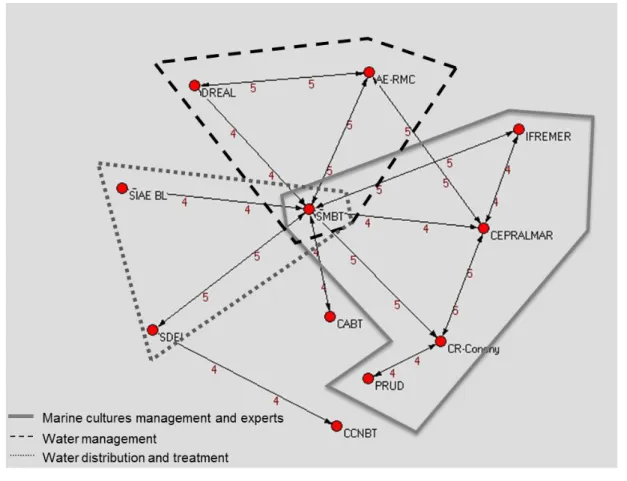
The intensity of contacts between stakeholders is represented in Figure 4. Highly connected 371
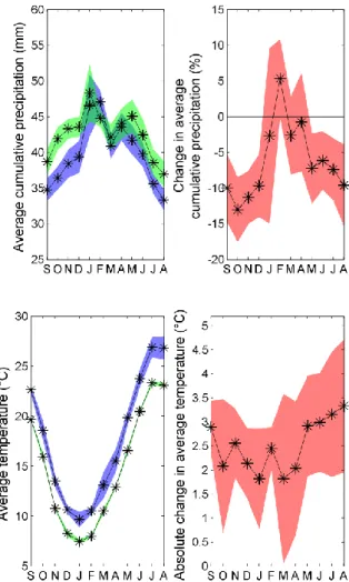
stakeholders include the following: DREAL and the water agency (AERMC) which represent local state 372
representatives and are directly concerned by the implementation of the WFD; SIAEBL is the most 373
importation water production syndicate for the Thau territory; SDEI coordinates wastewater treatment; 374
CABT and CCNBT are the two main groups of municipalities of the Thau territory; Ifremer is a 375
research Institute that locally investigated the surveillance of water quality of the Thau lagoon and the 376
safety of shellfish for commercialization; Cepralmar is the regional center for promoting the production 377
of marine cultures; and CR-Conchy is the regional council for the marine cultures survey, while PRUD 378
is the local representative of marine culture activities. 379
380
Figure 4: Betweenness centrality within the water social network. The frequency of contacts represented 381
is monthly for the value 4 and weekly for the value 5. Acronyms are defined in the section presenting SNA 382
methods. 383
The graph in Figure 4 reveals that water uses and water managers are highly connected (weekly 384
contacts with the value 5 and monthly contacts with the value 4). Stakeholders are in direct and 385
frequent contact with SMBT (eight nodes) except for CCNBT. However, such absence of a link 386
between two stakeholders does not mean a complete lack of connection, just rather occasional 387
connections. SMBT has the highest betweenness centrality making it in a very influential position as it 388
connects many stakeholders together. Three other stakeholders have three nodes of connection: 389
Cepralmar, AE-RMC and CR-Conchy. These are key stakeholders for the network as they provide 390
contact with other parts of the network. 391
The analysis shows that SMBT is the only stakeholder which connects three sub-networks: (i) the first 392
handles marine production comprising shellfish farming and brings together research expertise on 393
both environmental and farming issues (Ifremer) and local and regional managers of marine 394
production (PRUD, CR-Conchy, Cepralmar); (ii) the second relates to water management with water 395
policy implementation (AERMC, DREAL); and (iii) the third addresses drinking water production and 396
supply (SIAEBL, SDEI) and waste treatment. Communities of communes (CABT and CCNBT) can be 397
considered more external to these sub-networks and are connected through SMBT. SMBT is the most 398
central and influential stakeholder as it connects, directly or indirectly, all the local stakeholders. This 399
position is confirmed by the importance of transfer of information as shown Figure 5 and Figure 6, 400
SMBT is central both for the centrality in (they receive information from the stakeholders of the water 401
network, Figure 5) and the centrality out (they provide information to stakeholders of the water 402
network, Figure 6). 403
What is also important is that sub-networks (i) and (ii) represent the Lagoon Monitoring Network 404
(LMN). This network, established in 2000 to diagnose, on the basis of a set of several indicators, the 405
different ecological statuses of compartments of lagoon ecosystems in 23 lagoons of the LR region. 406
This network objective was clearly presented as a way to build governance on a network linking 407
managers and scientists. The fact that LMN was hosted by Cepralmar also complies with the priority 408
given to the use of the lagoon waters for shellfish farming. In fact, this water use, as one of the most 409
exigent regarding water quality and economically very important for the territory, was considered to 410
integrate all water uses of the catchment and coastal lagoons. 411
In summary, SNA confirms the central position of SMBT and the strong focus of water management 412
towards lagoon water quality and shellfish farming. The Water Agency (AE-RMC) nevertheless keeps 413
a prominent role in local water management issues. The governance of network type is very important 414
in the local water management of the Thau catchment, and it involves a mix of public and private 415
actors, including municipalities and the regional water basin authority on the public side. The French 416
government (DREAL) has a relatively peripheral position. 417
418
Figure 5: Centrality in for stakeholders in the Thau case study. Numbers represent the number of arrows 419
directed to the node. Acronyms are defined in the section presenting SNA methods. 420
421
Figure 6: Centrality out for stakeholders in the Thau case study. Numbers represent the number of arrows 422
directed from the node. Acronyms are defined in the section presenting SNA methods. 423
Does climate change threaten the Thau territory?
Climate change impacts on the Thau territory
425
While the projected precipitation closely follows the seasonality and the monthly variability of the 426
reference period, there is a clear tendency to a generalized decrease in the magnitude values across 427
all months over the Thau catchment (Figure 7). This reduction is expected to range from -14 to -2% 428
according to the CME mean values. An exception is made for February where the mean trend projects 429
an increase of +5% in precipitation. However, the CME uncertainty interval suggests further decrease 430
ranging from -18 to -5% from September to December, from -14 to +10% from January to April and 431
from -15 to -2% in late spring and during the summer months. These values reflect the large 432
uncertainty and variability in CME projections particularly in the winter months. 433
434
Figure 7: Projected change in reference cumulative precipitation (upper panel) and average monthly 435
temperature (lower panel) as predicted by the ensemble multi-climate models in the Thau catchment. 436
Light gray (green) represents the reference period (1971-2000) and dark gray (blue) represents the future 437
period (2041-2070). The black line with black stars refers to the mean value. 438
When comparing the magnitude of the average monthly temperature projection with that of the 439
reference period, there is clear evidence that climate models become more uncertain in simulating 440
temperature in the 2050s. All climate models project a general tendency towards warmer conditions 441
over the Thau catchment. The projected magnitudes of change suggest that the reference monthly 442
temperature is likely to increase by 1.7 to 3.2°C depending on the season. The highest increase in 443
temperature is projected for summer months when the summer season (JJA) reference average 444
temperature will increase by 3.1°C in the 2050s according to the mean value of CME. In contrast with 445
precipitation, the projected uncertainty in the magnitude of change in temperature decreases from the 446
dry months to the wetter months. By considering the uncertainty range of the values, the average 447
monthly reference temperature is likely to increase by 2 to 4.6°C in summer, 1 to 3°C in winter, 0.1 to 448
4°C in spring and 0.7 to 3.4°C in autumn. 449
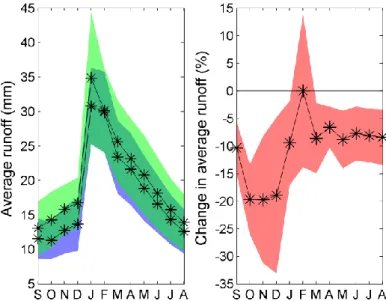
These new warmer conditions would exacerbate the evapotranspiration process with a potential 450
increase in irrigation needs. In the meantime, the water balance will also decrease with decreasing 451
precipitation, with implications for runoff. Indeed, there is a clear tendency to less runoff in the future 452
with respect to the reference period in the Thau catchment (Figure 8), with a marked decrease in the 453
wet months, from October to December, with an average reduction of -20% with respect to the 454
reference value. Summer monthly runoff is also expected to decrease with an average value of -8%. 455
However, there is an increasing uncertainty in the projected relative change of the reference runoff 456
from the dry period to the wet period. Runoff is expected to decrease in the 2050s by a range between 457
-13 and -3% in summer, between -33.8 and -1.8% in winter (without considering February), between 458
-31 and -5.5% in autumn and between -10.3 and -2.2% in spring. 459
460
Figure 8: Projected change in reference runoff as predicted by the ensemble multi-climate models in the 461
Thau catchment. Light gray (green) represents the reference period (1971-2000) and dark grey (blue) 462
represents the future period (2041-2070). The black line with black stars refers to the mean value. 463
In general, due to the combined decrease in precipitation and increase temperature, it is very likely 464
that the Thau catchment will experience a general tendency toward less availability of freshwater in 465
the future with respect to the reference period. This will induce a decrease in freshwater input into the 466
lagoon and probably an increase in water salinity. Moreover, these results do not consider the possible 467
additional impacts of the decrease in runoff on the recharge of the karstic aquifer in both baseline 468
discharge in the Vène River and the on unassessed volumes of freshwater entering the lagoon via 469
underwater springs as the Vise aforementioned. 470
Rivalries between water uses
471
First, all water uses mentioned are potentially in competition with one another in the Thau lagoon. The 472
only use which does not generate any mention of dispute or competition is industrial use. 473
There are many disputes in the Thau lagoon, and the list of rivalries provided by stakeholders is 474
mainly related to water quality in the lagoon. The disputes mentioned all date back to less than 10 475
years. One user mentioned 1975-1990 as a period in which water quality worsened significantly and 476
when major anoxic crises in the lagoon started, affecting all uses of the lagoon with major conflicts. 477
This user also explains that this gave rise to initial discussions between users. 478
The biggest number of responses refers to shellfish activity in the lagoon, and this is mentioned both 479
inability to sell shellfish due to water quality problems in the lagoon (microbial contamination and 481
anoxic crises due to eutrophication). These problems are described as being not completely resolved; 482
also, the awareness of these problems is improving following a number of study and research 483
programs undertaken to predict and anticipate crises and which involve decentralized government 484
services and local authorities. 485
The spa activity in Balaruc-les-Bains is also mentioned by both users and managers as provoking 486
frequent disputes with fishermen. The inversac phenomenon is always associated with problems, 487
although the complexity of this phenomenon makes it difficult to clearly identify causes for 488
stakeholders. While the spa is the more impacted activity during inversac, fishermen consider the spa 489
to be partly responsible. 490
Tourism is also mentioned both for its impact on water quality (due to urban waste or directly in the 491
lagoon due to recreational boats) and for the necessity to preserve bathing water quality in the lagoon. 492
Although the description of the impacts is vague, this use is perceived to be routing water away from 493
other activities: spa, environmental and freshwater users highlight the need to fight against salinization 494
of the lagoon in the summer. Irrigation seems to be a very local problem only in one town (Villeveyrac). 495
The impact of ferti-irrigation of vineyards using chemical products and the need for acids to clean the 496
pipes is described in detail. The problem concerns both competition for the resource and the cause of 497
pollution. 498
As for issues unrelated to conflicts of use, the impact of the increase in salinity of water on fauna and 499
flora is mentioned without further detail. 500
As far as the described rivalries between water uses in relation to the quality of the waters of the Thau 501
coastal lagoon, climate change impacts, such as an increase in temperature and salinity of the waters, 502
are perceived to probably aggravate tensions between water users. 503
The regional water scarcity adaptation strategy including Thau territory
504
In the Thau territory, demographic pressure is increasingly tough, not only because of the influx of 505
tourists but also due to the resident population. The latter has particularly accelerated since the 506
building of the strip of the A9 motorway which connects Nîmes, Montpellier, Béziers, Narbonne and 507
Perpignan to Spanish Catalonia via the Pyrenees. In fact, Montpellier is an employment hub, whereas 508
the basin of Thau has a high rate of unemployment; however, housing costs are very high in 509
Montpellier and its neighboring suburbs. The villages in the Thau basin are therefore highly sought 510
after as they are less than 40 km from Montpellier. The water sources of the catchment area have 511
never been sufficient to supply the population. Water from surges and aquifers has been imported 512
from the Hérault area for several decades with the exploitation of local surges currently degraded by 513
an increasing salinity. However, as mentioned above, in February 2012, water was routed from the 514
Rhône River within the framework of the regional Aqua Domitia project for distribution after treatment 515
by the SIAEBL Water Syndicate. This project shows how domestic use represents an important part of 516
water uses in the basin and how dependent the basin is now on external regions, despite being in the 517
same hydrographical district in view of the WFD. 518
Coherence between regional and local water governance
519
The great malaïgue of 1975 of the Thau coastal lagoon, an anoxic crisis related to eutrophication of 520
waters which affected the entire lagoon with the loss of all shellfish that had been bred, led all local 521
policies to focus on the necessity to recover the water quality of the lagoon to support one of the main 522
economic activities of the Thau territory: shellfish farming and fishing justified for its major input to the 523
socio-economic life of the region. A SMVM has been implemented to work on resolving conflicts due to 524
the diversity of human activities in the coastal zone, representing the intention to develop ICZM around 525
the Thau lagoon ecosystem. Scientific investigations of the quality of the lagoon were set up in 526
interaction with the study of the impacts of human activities from the catchment to understand the 527
connection between human activities and water quality of the lagoon.At that time, eutrophication was 528
the main threat according to nitrate (Plus et al., 2006) and phosphorous load assessments (La 529
Jeunesse et al., 2002; La Jeunesse and Elliott, 2004). The need to comply with the WFD permitted the 530
structuring of scientific data on the transitional waters of the LR Region through the regional initiative 531
to launch the LMN. 532
Presently, the work to provide an integrated vision of the water quality of the hydrosystem by the 533
SMBT has been a success as proven by the results presented here as (i) the capacity of all 534
stakeholders groups to make the link among water quality of the coastal lagoons, outputs from the 535
catchment and the support to shellfish farming and fishing activities; (ii) the intensive local water 536
network around the cornerstone actor SMBT which drives an efficient governance for the restoration of 537
water quality; and (iii) the dissemination of knowledge to all stakeholders through activities of the LMN. 538
The high quality database on the ecological quality of regional coastal lagoons maintained by the LMN 539
biogeochemical budget methodology (Gordon et al., 1996) and led to the DSS tool called 541
O’GAMELAG (LMN, 2013). This DSS has been implemented in one regional coastal lagoon, Bages-542
Sigean, and it was planned to for implementation in the Thau coastal lagoon. Those data are even 543
largely used to perform environmental impact assessment studies in the region by several public and 544
private bodies comprising Natura 2000 assessments. Thus, this database is supporting analysis to 545
preserve both the good ecological status of the lagoon in relation to nutrients and the shellfish farming 546
production in the context of urban development in the catchment. This high level of connection of 547
stakeholders is the result of twenty years of collaborative actions between stakeholders on the support 548
of scientific expertise. Local citizens still remember the difficulties of awareness and negotiations 549
steps, including several important local crises as the destruction of the Ifremer research center in 1987 550
by shellfish farmers who were, at that time, not aware of the new water quality issues in the coastal 551
lagoon. Communication among all water uses has been the only support of the integration of water 552
quality, but it has been supported day after day by relevant databases and models developed and 553
presented by local experts and grouped in LMN. Additionally, this capacity to restore water quality is 554
due to the dynamism of the SMBT to drive the local network because of its singular position as it acts 555
on the behalf of CABT and CCNBT. 556
This permitted the provision of a SCoT coherent with the SAGE. SAGE and SCoT both consider water 557
uses and water quality issues related to shellfish farming as the criteria of integration. Then, SMBT 558
provides clearly, even on its website, the need to control urban development on the territory to prevent 559
its possible unsustainable impacts on water quality of the Thau lagoon. 560
In this context, the provision of an ‘unlimited’ water resource to sustain the drinking water production 561
of the Thau territory by the new hydraulic connections and the forecasted regional mutation of 562
agricultural practices raise questions. This seems incoherent with the control of the urban spread and 563
the regulation of human activities development at risks for water quality. Environmental and long-term 564
water management concern have been clearly exposed during the public debate on Aqua Domitia 565
project as for the main points of the list relevant for the Thau territory: the decrease in awareness of 566
water economy, the heterogeneity for farmers to access to this new resource, the switch from several 567
to one unique source of water for drinking water production as local communities could not afford to 568
invest in both the maintenance of the old production system and the treatment of the water coming 569
from the Rhône River, the use of water by industrial instead of agricultural activities that has justified 570
investments for bringing water initially for irrigation, new water quality issues in the water bodies 571
induced by contaminants contained in water for irrigation such as PCBs and diuron that are a very 572
recent concern for the Thau lagoon, the intrusion of new pesticides in the drinking water even if they 573
remain on legal concentration after dilution with unpolluted sources of water, and so forth. 574
One interesting question for this paper was related to the governance of Aqua Domitia. The need for 575
trans-basin governance induced by the specificities of the Aqua Domitia project is claimed by 576
stakeholders with particular insistence from water managers. If the LR region recalled the vocation of 577
public interest, BRL, as the dealer, some participants do not state less distrust toward the potential 578
market behavior of this company. Furthermore, some studies have revealed the under-exploitation of 579
the water already dedicated to irrigation, and this could have been interpreted as an already existing 580
safety margin in the context of climate change impacts (Ghiotti and Honegger, 2009). 581
In the meantime, the Thau agglomeration (CABT) presented Aqua Domitia as a response to the 582
specific challenges of their territory. SAGE-Thau, which also participated in this public debate, used to 583
support Aqua Domitia project explaining it as the only way to ease pressure on the fragile aquatic 584
water bodies following studies conducted by the Water Agency. In fact, the impact of climate change 585
on the Thau hydrosystem which would manifest in a decrease in freshwater outputs from the 586
catchment to the coastal lagoon and its associated wetlands has even been confirmed by this study. 587
SAGE-Thau also defended the position of the absolute need to clarify the governance of this new 588
resource, and thus we think the establishment of regional versus local water governance will be 589
challenging in the coming years. 590
The 184 pages of this public debate report induced 3 pages of synthesis of the decisions from BRL. 591
The most important one for the Thau territory is that BRL has decided to participate, together with the 592
LR Region, in deploying a system of consultation with stakeholders and public information including 593
strengthening the system of information on water quality in collaboration with experts of reference in 594
the field of water quality. Thus, the network of stakeholders is equivalent to that represented the LMN! 595
However, because the LMN reached its goal of delivering an operational DSS to local stakeholders, 596
the LR region decided to end this network by not providing any financial support (representing less 597
than 300,000 euros per year) to a new plan of action. LMN ended in 2013, and the DSS O’GAMELAG 598
will not be implemented for the Thau stakeholders. 599
Thus, whereas (i) France has to answer to the European Union for its lack of a definition for vulnerable 600
areas related to the Nitrates Directive in the Thau catchment; (ii) the Thau catchment is ungauged 601
despite being regularly mentioned as a pilot site for integrated management in the coastal zone with 602
the creation of hydrological indicators; and (iii) the Thau territory has initiated a period of evolution of 603
the local water resource governance; the LR Region has denied local authorities of adequate scientific 604
expertise. The water quality expertise is no longer organized as one voice in the water network, and 605
the knowledge on several lagoons is no longer capitalized to deliver a consistent message on the 606
state of ecological quality of regional coastal lagoons necessary to provide new indicators to face 607
climate change impacts on the hydrosystem. Perhaps the next directive on Marine Spatial Planning 608
and Integrated Coastal Management would permit the network to re-establish, but, in any case, this 609
situation is a proof of the lack of awareness of climate change-induced impacts on local territories. 610
Thus, scientists have to continue their efforts of disseminating their results as highly requested, at 611
least, by the European Research Framework programs. 612
Conclusions
613
The results of the study presented in this paper expose that rivalries which took place in the past in the 614
Thau coastal lagoon are declared by stakeholders to be related to water quality issues in the lagoon. 615
Today, the water quality restoration is the result of twenty years of several multi-disciplinary programs 616
alternately conducted by scientists and by the local public bodies. Moreover, this has been possible 617
through two main factors. Firstly, as confirmed by the SNA outputs, through the central position of the 618
public body SMBT and the strong focus of water management towards lagoon water quality and 619
shellfish farming. Secondly, through the creation by the LR region of the LMN in 2000 to provide a 620
common knowledge base between stakeholders (both water users and water managers), experts and 621
scientists for implementing integrated management solutions for the transitional waters. 622
Climate change is likely to bring the context of relations between users of the water resource in tense 623
situations similar to those happened in the past. Specifically, 2050s projections indicate that yearly 624
mean precipitation is expected to decrease from about 2% to about 15%, while conversely 625
temperature is expected to increase on average from about 2°C to about 3.5°C. The temperature 626
increase will exacerbate the evapotranspiration process, leading to a dryer soil moisture conditions, 627
which will require larger water quantity for irrigation, while precipitation decrease will be obviously 628
reflected in lower runoff production. These critical changes will imply potential negative impacts on 629
water quality comprising anoxic crises. 630
In order to answer to climate change impacts, the LR region managed the Aqua Domitia project to 631
conduct freshwater from the Rhône to the Thau catchment to supply irrigation needs. This water is 632
already used for drinking water production supplying industrial, domestic and tourism water uses. 633
While the SMBT is devoted to control the urban spread and the regulation of human activities 634
development on its territory with the two main tools represented by the SCoT and the SAGE Thau, this 635
provision of an “unlimited” water resource can be considered as incoherent. Moreover, as this paper 636
demonstrates, the absence of perception of both water transfer and climate changes impacts, the 637
dissemination of threats due to climate change and the use of the untreated water of the Rhône River 638
or the water quality of the lagoon is really needed. The specificities of the Aqua Domitia requires a 639
trans-basin governance which could have relied on the existing LMN. However, the LR region decided 640
to end its financial support to the LMN in 2013! Since then, stakeholders no longer have contact that 641
can meet with an integrated approach to their problems. More importantly, the methods used to 642
resolve situations in the past could be inefficient for future situations. In the present state of knowledge 643
on the impact of climate change, it is likely that the chains of cause and effect for achieving the same 644
situation of deterioration of water quality are different. Thus, the tools previously developed, including 645
those offered by the LMN, although operational and valid today for some regional coastal lagoons, can 646
become obsolete if not updated continuously with the increase in knowledge about all the criteria 647
explaining the chain of cause and effect between climate change and water quality. 648
The political decision to end this network, beyond demonstrating a lack of appreciation of the issues of 649
the territory, can be much more problematic for some time as it will induce rearrangements of this 650
network. There is every reason to think the establishment of regional versus local water governance 651
will be challenging in the coming years. Indeed, by denying the territory to continue in developing its 652
own methods of water quality management, it increases the risk of development outside the 653
challenges of climate change, that is to say, unsustainable development or maladaptation. This 654
contributes to increase the vulnerabilities of the Thau territory to climate change impacts. 655
Acknowledgments
656
This paper was funded by the European Commission Seventh Framework Program through the 657
CLIMB project, Grant Number 244151. We would like to thank our scientific coordinator, Ralf Ludwig, 658
for his support all along the duration of the project. We would like to thank the stakeholders visited in 659
the CLIMB case studies for their fruitful and engaged participation in this study. Without their 660
contribution and cooperation, this study would not have been possible. We also thank Gaëlle Pellon 661
for the fruitful exchanges on SNA techniques and Corinne Larrue and Virginie Gillet for their 662
contribution to the elaboration of the questionnaire dedicated to the water use analysis. Last but not 663
least, we thank the Maison des Sciences de l’Homme for proposing the services of a competent 664
cartographer. 665
References
666
Aqua Domitia, Région Languedoc-Roussillon Region et Bas-Rhône Languedoc, 2011. Le dossier du 667
maître d’ouvrage. Débat public du 15 septembre au 29 décembre 2011, 116 p., 668
http://debatpublic-Aqua Domitia.org/
669
Arnold, J.G., Srinivasan, R., Muttiah, R.S., Williams, J.R., 1998. Large area hydrologic modelling and 670
assessment. Part I: model development. J. Am. Water Resour. As., 34 (1), 73–89. 671
Aubin, D., 2008. Asserted rights; rule activation strategies in water user rivalries in Belgium and 672
Switzerland. J. Public Policies, Vol. 28(2), p.207-227. 673
Badas, M.G., Deidda, R., Piga, E., 2006. Modulation of homogeneous space-time rainfall cascades to 674
account for orographic influences, Nat. Hazard. Earth Syst. Sci., 6, 427–437, 675
doi:10.5194/nhess-6-427-2006. 676
Barnes, S.L., 1964. A technique for maximizing details in numerical weather map analysis. J. Appl.
677
Meteor., 3, 396–409.
678
Barnes, S.L., 1973. Mesoscale objective analysis using weighted time-series observations. NOAA
679
Tech. Memo. ERL NSSL-62, National Severe Storms Laboratory, Norman, OK, 60 pp.
680
Batagelj, V., Mrvar, A., 1998. Pajek: a program for large network analysis. Connections, 21(2): 47-58. 681
Beaud, S., 1996. L’usage de l’entretien en sciences sociales. Pladoyer pour l’entretien 682
ethnographique, Politix, 9(35) : 226-257. 683
Bertacchini, Y., Maurel, P., Deprez, P., Plant, R., 2013. Spatial information & communication 684
arrangements: a contribution to territorial intelligence. Journal of Emerging Trends in Computing 685
and Information Sciences. 4(1): 19-28. 686
Bevir, M., 2013. A theory of governance, University of California Press, 263 p. 687