HAL Id: tel-00871982
https://tel.archives-ouvertes.fr/tel-00871982
Submitted on 11 Oct 2013HAL is a multi-disciplinary open access archive for the deposit and dissemination of sci-entific research documents, whether they are pub-lished or not. The documents may come from teaching and research institutions in France or abroad, or from public or private research centers.
L’archive ouverte pluridisciplinaire HAL, est destinée au dépôt et à la diffusion de documents scientifiques de niveau recherche, publiés ou non, émanant des établissements d’enseignement et de recherche français ou étrangers, des laboratoires publics ou privés.
Caractérisation géodésique de la déformation active du
point triple d’Hatay (Syrie-Turquie)
Yasser Mahmoud
To cite this version:
Yasser Mahmoud. Caractérisation géodésique de la déformation active du point triple d’Hatay (Syrie-Turquie). Earth Sciences. Université de Strasbourg, 2012. English. �NNT : 2012STRAH006�. �tel-00871982�
Université de Strasbourg
Ecole et Observatoire des Science de la Terre Institut de Physique du Globe de Strasbourg - UMR 7516
Ecole doctorale des Science de la Terre, de l’Univers et de l’Environnement
Thèse de doctorat de l’Université de Strasbourg
Soutenue le : 22 Novembre 2012
Discipline : Géodésie
Présentée par Yasser MAHMOUD
Titre
Caractérisation géodésique de la déformation active du point triple
d’Hatay (Syrie-Turquie)
Jury
M. Pierre BRIOLE ………... Rapporteur externe M. Ziyadin CAKIR ………... Examinateur M. Jacques HINDERER ………..… Rapporteur interne M. Frédéric MASSON ……….. Directeur de thèse M. Mustapha MEGHRAOUI ……… Co-Directeur de thèse M. Philippe VERNANT ………... Rapporteur externe
I
Acknowledgement
At the end of my thesis, I would like to thank all those people who made this work possible and an unforgettable experience for me.
First of all, I would like to express my deepest sense of gratitude to my two supervisors Professors Frédéric MASSON and Mustapha MEGHRAOUI, for accepting to supervise my thesis, for their continuous advices and encouragements throughout the course of this thesis, for their insightful comments and hard questions. I thank them also for the systematic guidance, great effort they put into training me in to the scientific research, for all what I listed and what I did not my sincere gratitude.
I am particularly grateful for the support and encouragement by the “Dynamique Globale et Déformation Active” group at the Institut de Physique du Globe de Strasbourg (IPGS) of University of Strasbourg. It was not only a pleasure to work and study with you, but your suggestions, comments, criticisms, and friendship along the way have been very helpful.
I would like to acknowledge all the members of my thesis Jury for accepting to evaluate and examine my work. I am grateful to Professors Pierre BRIOL, Philippe VERNANT and Jacques HINDERER for reviewing this manuscript and for their constructive criticism. I am also very thankful to Professor Ziyadin CAKIR for examining the present work.
My thanks go also to the National Earthquake Center (NEC, Syria), the Marmara research center (TUBITAK, Turkey) and The Istanbul Technical University for providing permanent GPS data. I thank them also for providing equipment and assistance during data acquisition steps in the field and for the GPS campaigns carried out in Syria and in Turkey. Their supports were much appreciated. Particular thanks to all the teams from these institutions that participated and helped during field work. Thanks to Hakan Yavasoglu, Onder Yonlu, Rahsan Çakmak, Sedat Inan, and Semih Ergintav from Turkey, Abdulmutaleb Alchalbi, Reda Sbeinati, Mohammad Abou Romieh, Adham Alsaoud, Rayan Yassminh, Basel Ballani, Marwan Alkasser, and Mohamad Daoud from Syria, Jacques Durand and Sheldon Warden from France.
My special gratitude goes also to Prof. Ziyadin CAKIR for all his contribution and support to make my PhD experience productive, for the time he spent during the field of this
II
thesis, and also for providing insightful ideas especially about the block modeling and DEFNODE program.
Special thanks to, Patrice Ulrich for giving the technical assistance for data processing using GAMIT/GLOBK, to EOST’s administrative staff.
My thankful to my colleagues Maxime, Pierre, and Julien, for the three years we shared the office as well as the funny and depressed moments, for their care and precious friendship and support during my stay at the EOST. I do not forget my Syrian and other nationalities friends in France, the list is long, thanks to all of you.
I give my sincere thanks to Dr. Samir Belabbes for his support, for his valuable advices and friendly help. He provided all along the thesis encouragements, sound advices, and constructive discussions.
My thesis scholarship was funded by the Syrian Government through the Syrian Ministry of High Education. I would like to express them my gratitude for continuously funding my scholarship especially for the last year where my country confronted many financial difficulties.
I would like to express my heart-felt gratitude to my parents, my brothers, my sister, my sister in law, and my nephew for their continuous care, and support. None of this would have been possible without their love.
Last, but not least, I would like to thank my fiancée Walaa for standing beside me throughout my career and during the different steps of this thesis. She gave me love, support, and encouragement. She was continuously my inspiration and motivation for continuing to improve my knowledge and step forward my career. She is my rock, and I dedicate this work to her.
Table of contents
III
Table of contents
ACKNOWLEDGEMENT ... I
TABLE OF CONTENTS ... III ABSTRACT ... VII
RESUME ... IX
INTRODUCTION ... 1
CHAPTER I ... 7
I- THE DEAD SEA FAULT ... 7
I.1 Introduction ... 9
I.2 Tectonic setting of Dead Sea Fault ... 12
I.2.1 General tectonic setting ... 12
I.2.2 Eastern Mediterranean geodynamics ... 13
I.2.3 Dead Sea Fault segments ... 14
I.2.3.1 Wadi Araba ... 14
I.2.3.2 Jordan Valley ... 15
I.2.3.3 Beqa’a Basin (Lebanese restraining bend) ... 15
I.2.3.4 Al-Ghab basin ... 16
I.2.3.5 Karasu Fault ... 17
I.3 Seismicity of Dead Sea Fault ... 17
I.3.1 Historical seismicity ... 17
I.3.2 Instrumental seismicity ... 21
I.4 Kinematisc of Dead Sea Fault ... 24
I.4.1 Geodynamic of the Dead Sea Fault ... 24
I.4.1.1 Long term deformation ... 24
I.4.1.2 Short term deformation (GPS) ... 26
I.5 Conclusion ... 32
CHAPTER II ... 35
II- THE EAST ANATOLIAN FAULT ... 35
II.1 Introduction ... 37
II.2 Tectonic settings of the East Anatolian Fault ... 37
II.2.1 General View ... 37
II.2.2 East Anatolian Fault segments ... 39
II.2.3 The total offset ... 41
Table of contents
IV
II.3.1 Historical seismicity ... 42
II.3.2 Instrumental Seismicity ... 44
II.4 Kinematic of the East Anatolian Fault ... 46
II.4.1 Long term deformations ... 47
II.4.2 Short term deformations (GPS) ... 48
II.5 Conclusions ... 49
CHAPTER III ... 51
III- GPS NETWORK IN NORTH-WEST SYRIA AND SOUTH-EAST TURKEY ... 51
III.1 Introduction ... 53
III.2 Global position system and plate kinematics ... 55
III.2.1 What is GPS... 55
III.2.2 GPS segments ... 56
III.2.2.1 Space segment ... 56
III.2.2.2 Control segment ... 56
III.2.2.3 User segment ... 57
III.2.3 GPS observables ... 57
III.2.3.1 The GPS code measurement ... 57
III.2.3.2 GPS carrier phase measurement ... 58
III.2.4 GPS linear combinations ... 59
III.2.4.1 Single-difference combination ... 59
III.2.4.2 Double-difference combination ... 59
III.2.5 Resolution of ambiguity ... 60
III.2.6 Plate kinematics ... 61
III.2.7 The International Terrestrial Reference Frame: ITRF2005 ... 64
III.3 GPS network in the Hatay Triple Junction ... 66
III.3.1 GPS network installation ... 66
III.3.2 GPS campaigns in Syria and Turkey ... 68
III.3.2.1 Campaigns of 2009 ... 68
III.3.2.2 Campaigns of 2010 ... 70
III.3.2.3 Campaign of 2011 ... 70
III.3.3 GPS measurement strategy ... 72
III.4 GPS Data processing with GAMIIT ... 73
III.4.1 GPS processing method in GAMIT... 73
III.4.2 Stabilization: Permanent IGS sites ... 73
Table of contents
V
III.5 Results ... 80
III.5.1 GPS velocity field in ITRF2005 reference frame ... 80
III.5.2 GPS velocity field in Eurasia reference frame ... 84
III.5.3 GPS velocity field in Arabia reference frame ... 88
III.6 Conclusions ... 95
CHAPTER IV ... 97
IV- BLOCK MODELING WITH GPS MEASUREMENTS ... 97
IV.1 Introduction ... 99
IV.2 Data and analysis ... 100
IV.2.1 Data selection and rejection ... 100
IV.2.1.1 GPS data obtain in this study ... 100
IV.2.1.2 GPS data from previous studies ... 101
IV.2.2 Combination of different GPS velocity solutions... 102
IV.3 Inversion approach (Method) ... 103
IV.4 Faults ... 104
IV.5 Block model ... 106
IV.6 Modeling results ... 109
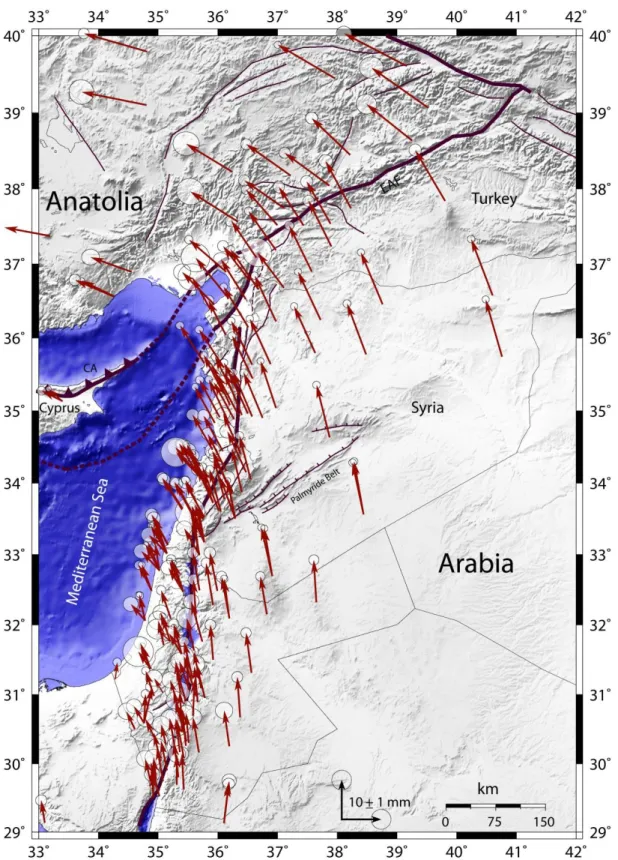
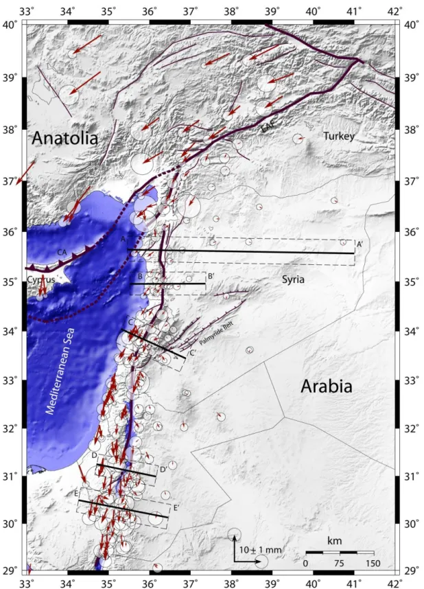
IV.6.1 Profiles across major faults ... 114
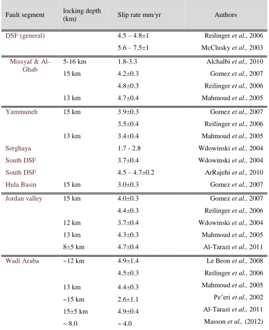
IV.6.2 Slip deficit, locking depth and variation of ɸ ... 117
IV.6.3 Fault slip rates ... 120
IV.6.3.1 The Dead Sea fault: ... 120
IV.6.3.2 The East Anatolian fault: ... 122
IV.6.3.3 The Karatas-Osmaniye fault: ... 122
IV.6.3.4 The Karasu fault ... 122
IV.6.3.5 The Cyprus Arc ... 123
IV.6.4 Block motions and rotation Euler poles ... 123
IV.7 Conclusions ... 126
CHAPTER V... 129
V- GENERAL DISCUSSION AND CONCLUSIONS: IMPLICATIONS TO THE REGIONAL SEISMIC HAZARD ... 129
V.1 Introduction ... 131
V.2 GPS velocity field and block model results in the HTJ ... 133
V.3 Slip rate and seismic hazard in the Triple junction ... 138
V.3.1 The Dead Sea Fault ... 139
V.3.2 The East Anatolian Fault ... 139
Table of contents
VI
V.3.4 The Karasu Fault ... 140
V.4 Conclusions ... 142
AUXILIARY MATERIALS ... 145
LIST OF FIGURES ... 161
LIST OF TABLES ... 167
Abstract
VII
Abstract
The active deformation at the Hatay Triple Junction (HTJ) in north-western Syria and south-eastern Turkey is a subject of debates essentially because of the tectonic complexity of the region. The HTJ is formed by the relative motion of Arabia, Anatolia, Sinai plates and the intersection of their boundaries represented by left-lateral Dead Sea Fault (DSF), the Cyprus subduction Arc and the left-lateral East Anatolian Fault (EAF). Recent GPS studies provide 18±2 mm/yr for the north-westward motion of Arabia toward Eurasia and 6±2 mm/yr for the northward motion of Africa toward Eurasia in the eastern Mediterranean (McClusky et al., 2003; Reilinger et al., 2006). Similar previous GPS studies indicate a left-lateral strike-slip rate across the DSF varying from 5.0 mm/yr (along the southern part) to ~2 mm/yr (along the northern part). In contrary, the EAF has a roughly constant velocity along strike estimated at 9.7 + 0.9 mm/yr (Reilinger et al., 2006). The HTJ contains several well-identified active fault segments (DSF, EAF, Karatas-Osmaniye fault (KOF), Karasu fault (KF), Lattakia fault, Jisr-al-shuggur fault, Idleb fault and Afrin fault) (Saroglu et al., 1992; Meghraoui et al., 2003; Tatar et al., 2004), the fault-slip rates for which are poorly constrained. Hence we decided to investigate and understand the strain accumulation rate and interseismic behavior across fault zones and related block tectonics in the vicinity of the HTJ.
A network of 57 GPS sites was established in the north-west Syria (33 points) and south-east Turkey (24 points) in the context of this study; our network was reinforced by 14 permanent sites belonging to a regional GPS networks in Syria and Turkey. The density of our GPS sites around the HTJ and the points distribution in 4 main profiles crossing the majority of fault zones in the region, might give the ability to identify at a relative small scale, the strain accumulation and the physical parameters of active faults in the region. Furthermore, our study would imply a better seismic hazard and risk assessment in one of the highly populated regions in the eastern Mediterranean.
In this study, we show that the active deformation and kinematic of the triple junction can be explained by a block model using GPS vectors. Using a block model with finite number of rotating elastic spherical blocks limited by faults, is more efficient to understand the kinematic of the triple junction. In such model, the fault receives a large amount of the deformation caused by the relative blocks movements. We used DEFNODE program to construct a 3D elastic dislocation model in which the tectonic plates are represented as closed
Abstract
VIII
spherical polygons on the lithosphere, limited by the faults which are represented in 3 dimensions by along-strike and down-dip nodes defining the geometry, direction, width, and dip angle of the faults. The block rotation and fault locking parameters are estimated using GPS velocities for inversion in an elastic and homogeneous half-space of Okada (1985).
We found that a simple model with three major plates proposed by previous studies fails to explain the GPS data used in this study, A more complex block model is proposed by adding the Iskenderun block and Amanous micro block, the Karasu fault and Karatas-Osmaniye fault being defined as individual faults not as the extension of other major faults in the region. Our modeling assumes that the Maras triple junction is formed by the connection of KOF with KF and EAF. The KF shows a sinistral slip rate of 4.0±1.0 mm/yr and a compressional behavior with a compression rate of 2.1-2.7 mm/yr which contradicts the extensional nature proposed by previous studies. The EAF shows pure left lateral slip rate of 9.0±0.3 mm/yr with no significant extension or compression; the DSF has a slip rate of 3.5±0.3 mm/yr over the northern and southern segments; the KOF has a 3.6±0.7 mm/yr; the Cyprus arc has a clear compressional deformation with a revers slip rate of 2.0-5.0 mm/yr and with no significant strike-slip component. The relative Euler poles are estimated in this block modeling, we define the Anatolia-Arabia Euler pole at (27.61±0.98 °N, 45.127±2.45 °E, 0.391± 0.056°/Myr), and (31.012±1.51 °N, 46.464±4.44 °E, 0.202±0.067°/Myr) Sinai-Arabia Euler pole.
Keywords: GPS, geodesy, active tectonic, Dead Sea fault, East Anatolian Fault, triple junction.
Abstract
IX
Résumé
Les déformations actives à la jonction triple d’Hatay (HTJ) dans le nord-ouest de la Syrie et le sud-est de la Turquie est toujours un sujet de débats en raison de la complexité tectonique de cette région. La HTJ est formée par le mouvement relatif des plaques Sinaï, Arabie, et Anatolie, et l'intersection de leurs limites représentées par la faille senestre de la Mer Morte (DSF), l'Arc de subduction de Chypre et la faille senestre Est Anatolien (EAF). Des études GPS récentes indiquent un déplacement de 18±2 mm/an pour le mouvement nord-ouest de l'Arabie vers l'Eurasie, et 6±2 mm/an de déplacement nord de l'Afrique vers l'Eurasie dans l’Est de la Méditerranée (McClusky et al., 2003; Reilinger et al., 2006). Ces mêmes études GPS indiquent un taux décrochement senestre à travers le DSF variant de 5 mm/an (le long de la partie sud) à ~2 mm/an (le long de la partie nord). En revanche, l'EAF a une vitesse à peu près constante le long de la faille estimée à 9.7±0,9 mm/an (Reilinger et al., 2006). La HTJ est composée de plusieurs segments de failles actives bien identifiés (DSF, EAF, Faille Karatas-Osmaniye (KOF), Faille de Karasu (KF), Faille de Lattaquié, Faille de Jisr Al-Shuggur, Faille d’Idleb et la Faille d’Afrin), mais le taux de glissement de ces failles n’est toujours pas bien identifié. Cela nous a poussé à tenter de mieux comprendre et d’évaluer le taux d'accumulation des contraintes et le comportement inter-sismique afin de mieux contraindre les déformations actives et la tectonique de blocs associée dans le voisinage de HTJ. Dans cet objectif, un réseau de 57 sites GPS a été mis en place dans le nord-ouest de la Syrie (33 points) et au sud-est de la Turquie (24 points) dans le cadre des travaux de cette thèse. Notre réseau a été renforcé par 14 sites permanents appartenant à des réseaux GPS régionaux en Syrie et en Turquie. Ainsi, nous considérons que la densité de nos sites GPS autour de la HTJ et la distribution des points en 4 profils principaux qui traversent la majorité des structures tectoniques connus dans la région peuvent fournir des informations utiles permettant ainsi d'identifier, à une échelle relativement petite, les paramètres physiques et l’accumulation de déformations dans la région. En effet, ces résultats permettent une meilleure évaluation du risque sismique dans cette zone à fort densité de population.
Dans cette thèse, nous montrons que la déformation active et cinématique de la jonction triple peut être expliquée par un modèle de blocs en utilisant les vecteurs GPS. L'utilisation d'un nombre fini des blocs sphériques élastiques limités par les failles dans un modèle de bloc est plus efficace pour comprendre la cinématique de la jonction triple.
Abstract
X
Dans un tel modèle, les failles acquièrent une quantité importante de la déformation provoquée par les mouvements relatifs des blocs. Nous avons utilisé le programme DEFNODE pour construire un modèle de dislocation élastique 3D dans laquelle les plaques tectoniques sont représentés comme des polygones sphériques sur la lithosphère, et limités par des failles qui sont représentées en 3 dimensions par des nœuds distribuées sur le longueur et la surface de faille qui définissent la géométrie, la direction, la largeur et le pendage des failles. Les paramètres de la rotation des blocs et des profondeurs de blocage de failles sont estimés en utilisant les vitesses GPS pour l'inversion dans un demi-espace élastique et homogène d’Okada (1985).
Nous trouvons qu'un modèle simple à trois grandes plaques proposées par les études précédentes ne permet pas d'expliquer les données GPS utilisées, un modèle de bloc plus complexe est proposéen rajoutantles micros blocs d’Iskenderun et d’Amanous, la faille de Karasu et la faille de Karatas-Osmaniye ont été définies comme des failles individuelles et non pas comme l'extensiond'autres failles majeursdans la région. Notremodélisation assume quelajonctiontriple de Maras est formé par la connexion de KOF avec KF et EAF. Le KF montre un taux de glissement senestre de4,0±1,0mm/anetuncomportementde compression, avec un taux de raccourciede2.1 à 2.7mm/an, ce qui contredise la nature extensionnelle proposée par les études précédentes.L'EAF montre un taux pur de glissement latéral gauche de 9,0±0,3 mm/an sans extension ou compression significative, la DSFa un taux de glissement de3,5±0,3mm/ansur les segmentsnord et sud, la KOF a 3,6±0,7 mm/an; l'arc deChyprea une déformationde compressionclairavec un taux de glissement revers de 2.0 à 5.0 mm/an et sans significative dérochement. Les pôles relatifs d’Euler ont été estimés dans cette modélisation de blocs, nous définissons l’Euler pole de l'Anatolie-Arabie à (27.61±0.98 °N, 45.127±2.45 °E, 0.391±0.056 °/Ma), et l’Euler pôle de Sinaï-Arabie à (31.012±1.51 °N, 46.464±4.44 °E, 0.202±0.067 °/Ma).
Mots-Cles: Global positioning System (GPS), geodesy, active tectonic, Dead Sea fault, East Anatolian Fault, triple junction.
Introduction
1
Introduction
The study of active deformation and kinematics of the lithosphere showed significant progress in the last years thanks to the important advance in the space geodetic techniques. Among these techniques, the Global Positioning System (GPS) is one of the most useful techniques for the study of the earth’s crustal deformation. This technic provides an easy, low-coast, and accurate tool for the identification of active deformation at the large and regional scale.
In this study, we use GPS measurements in order to follow and monitor the active deformation at the Hatay Triple Junction, located in northwest of Syria and southeast of Turkey. The intersection between the Dead Sea fault (DSF), the East Anatolian fault (EAF) and the Cyprus Arc (CA) correspond to the Hatay Triple Junction (HTJ), forming the limits between Arabia, Africa and Anatolia. The Hatay tectonic zone is among the few Fault-Fault-Trench (FFT) triple junctions. Other comparable FFT triple junctions are the Mendocino (North America-Pacific-Juan de Fuca plates) and the Kamchatka-Aleutian (Eurasia-Okhotsk-North America plates) that are mainly in oceanic domains. The HTJ has the unique advantage to be partly intra-continental and offers a visible and accessible intersection between the EAF, the DSF and the Cyprus subduction zone. This region has a moderate seismic activity during the last century. However, the related faults segments experienced large and destructive historical earthquakes with magnitude greater than M = 7; some of these earthquakes like the events of 1114, 1408, 1513, 1822, 1872 are well documented and identified along the DSF and the EAF (Ambraseys and Jackson, 1998; Sbeinati et al., 2005).
The deformation and strain accumulation of the main plate boundary faults (EAF, DSF), between Arabia-Anatolia and Arabia-Africa respectively, have been documented in many and different previous geological (Arpat and Saroglu, 1972; McKenzie, 1976; Saroglu et al., 1992; Meghraoui et al., 2003; Westaway, 2004) and geodetic studies (Gomez et al., 2007a; Alchalbi et al., 2010). The majority of these studies assess the deformation rate in HTJ at a long term scale, from thousands to a few millions of years. The Dead Sea transform fault accommodates the relative motion between the Arabia plate (~20 mm/yr north-westward direction) and the Africa plate (~10 mm/yr northward direction), a differential accumulated left lateral strike-slip of 25-35 km was documented between the north and south parts of DSF which can be explained by the shortening through the Palmyride fold belt or by internal
Introduction
2
deformation caused by the fable rigidity of the northeast part of Sinai plate (Ambraseys and Barazangi, 1989; Westaway, 1994). Geological studies along the fault indicate a slip rate of 4-7 mm/yr (Quennell, 1958; Freund et al., 1968; Freund, 194-70). Other estimations of slip rate ranging between 3 mm/yr and 10 mm/yr along the DSF were proposed from geomorphological studies for the last few thousands of years (Garfunkel, 1981; Niemi et al., 2001). Paleoseismological studies along different segment of DSF propose a slip rate of 5-7 mm/yr (Meghraoui et al., 2003; Akyuz et al., 2006; Ferry et al., 2011). The major Arabia-Anatolia plate boundary (EAF) has been the site of various geological and seismological studies, the previous long term estimations of slip rate along this plate boundary are also varying between 4 mm/yr and 19 mm/yr (Arpat and Saroglu, 1972; Lyberis et al., 1992; Yurur and Chorowicz, 1998; Westaway, 2003). The few geodetic studies in the region (mainly GPS studies) have been carried out mainly for large scale deformation assessment, such as the study of the geodynamics of the eastern Mediterranean or the convergence between the Arabia and Africa plates from one side and the Eurasia in the other side. GPS measurements were used to infer deformation rate along the DSF and the values proposed were significantly smaller than other long term estimations, especially in the northern part of the DSF. Studies of the Arabia, Africa, and Eurasia relative motions using GPS measurements indicate a slip rate of 4.5 – 6 mm/yr in general for the DSF (McClusky et al., 2003; Reilinger et al., 2006). Other regional geodetic studies agree with these estimations along the southern DSF (Le Béon et al., 2008; Al-Tarazi et al., 2011), but not along the northern segments where Alchalbi et al., (2010) propose a significantly smaller value of 1.8 – 3.3 mm/yr. In contrast, GPS studies agree with long term studies of slip rate of the EAF and no difference in the slip rate is obtained along the different fault segments.
The kinematic and the active deformation pattern of the Hatay triple junction remains unclear, and detailed investigations are necessary to a better understanding of the complex mechanic characteristics at the intersection between the major Arabia, Africa, and Eurasia plates.
Different reasons motivated us to perform this study in this Hatay Triple Junction and they can be summarized in the following.
- Most of the geodetic studies in the region were directed to understand plate motions or the kinematics of the region at large scale. However, the existence of small-scale tectonic features like the Afrin Fault, Idleb Fault, Karasu Fault,
Introduction
3
Karatas-Osmaniye Fault, Lattakia fault, Jisr-al-shuggur fault, and other potential micro blocks, makes the triple junction a complex tectonic domain. Previous studies were unable to determine the physical parameters of small faults and then their contribution to the regional deformation.
- The recent geodetic estimations of deformation and strain accumulation along the major faults need to be revised and well identified in details, after taking into account the several active sub-segments in the region. Especially, there is a significant difference in fault slip rate estimations between the short-term studies and other long-term studies (e.g., north of DSF). The slip rate, locking depth, and strain accumulation on all the active faults and sub-faults need to be determined in order to have a better image about the kinematics of this region.
- The seismic quiescence and the significant difference between historical and instrumental seismicity on all the related faults give the motivation to study the strain accumulation on these faults, and try to distinguish the role of each tectonic feature in the junction kinematic. The high-level of historical seismic activity implies that this region can produce destructive earthquakes. Our aim is to identify the major source of strain accumulation on related faults, and predict the magnitude and the return period of future large earthquakes.
A dense regional GPS network is needed in order to address these issues. Thus, we installed a network of 57 GPS sites around the Hatay triple junction in northwest Syria and southeast Turkey with mean inter-site distance of about 15 km. Our GPS network in Hatay region is designed to provide the best assessment of active deformation in the region. The space distribution of our GPS sites and the consistency with the previously existing sites, have been taken into account before installation. We installed 33 sites in Syria and 24 sites in Turkey; altogether, they form 4 main profiles cross the majority of active faults related to the Hatay triple junction. In 2009 and 2010, two campaigns of measurements were achieved where all the GPS points have been measured for 24 hours in each campaign; the last campaign was conducted in September 2011. In this campaign, only the sites in the Turkish side were measured. Unfortunately, political and social unrests appeared in Syria and our planned GPS campaign was impossible to achieve. The regional GPS campaign network was reinforced by 14 permanent GPS sites from the Syrian and Turkish GPS network. The collected data were processed using GAMIT/GLOBK (Feigl et al., 1993a; Dong et al., 1998)
Introduction
4
program, together with data of 71 International GPS Service (IGS) points distributed on the major plates around the region of study. Introducing these IGS sites in our processing provide stabilization frame and calibrate our measurements to the global GPS network, it is also used in the determination of the Euler pole and angular velocity of major tectonic plates.
After processing the collected GPS data and calculating the GPS velocity field around the Hatay triple junction, a block model was applied to estimate the strain accumulation along the faults and the blocks rotation parameters. The use of block model was necessary for such complex area, where a simple interpretation of GPS velocity field using 1D or 2D models is not sufficient for the detection of the active deformation. Therefore, we applied 3D elastic dislocation model using DEFNODE program (McCaffrey, 1995; McCaffrey, 2002).
Different model were tested in order to determine the best fit with the GPS data used in this study. We found that two micro blocks called Iskenderun and Amanous blocks are fundamental in the explanation of the active deformation in the triple junction of Hatay and a best fit to the GPS data cannot be obtained without representing the Karasu fault and Karatas-Osmaniye fault as independent faults and not as a continuation of the DSF or the EAF.
This thesis represents our work into five main chapters, we present the previous important studies achieved in our studied region, the GPS measurements and velocity field around Hatay triple junction, the GPS block modeling, and a discussion of our results.
The first and second chapters provide a review of the geodetic and geological studies of the Dead Sea fault and the East Anatolian fault respectively. The N–S trending DSF extends for 1000 km and makes the connection between the Red Sea mid-oceanic ridge (Aqaba Gulf) in the south to the triple junction area to the north where it joins the East Anatolian Fault (EAF) and the Cyprus Arc (CA). Several geological and geodetic studies estimate the rate of displacement along the DSF fault as 2 to 10 mm/yr (Alchalbi et al., 2010; Ferry et al., 2007; Freund et al., 1968; Garfunkel et al., 1981; Gomez et al., 2007; McClusky et al., 2003; Meghraoui et al., 2003; Wdowinski et al., 2004). A difference in slip rate is observed between the northern and southern of DSF. ~105 km of left lateral cumulative slip was documented on the south, while only 70 – 80 km was observed in the north (Quennell, 1958; Freund, 1970; Chaimov et al., 1990; Westaway, 2003). The North-West movement of the Arabia plate with rate of ~20 mm/yr results in 9.7 mm/yr of pure left strike-slip along the East Anatolian fault (McClusky et al., 2000; Reilinger et al., 2006). The EAF extends from Karliova triple junction for 600 km and connect to the HTJ. In these two chapters we compile
Introduction
5
all the GPS data available in the region and compare their results with results of other long term studies (geology, paleoseismology, and geomorphology) in order to validate the correlation between long-term and short-term estimations. It is noted that the velocity rates estimated by geodetic studies are in general lower than the slip rates proposed by the geological and geomorphological studies, especially along the DSF.
The third chapter shows and explains our GPS network installed to constrain the active deformation in the region of Hatay by means of GPS processing using GAMIT/GLOBK showing the first order results and velocity field.
We have installed 57 GPS sites in the region (33 in Syria and 24 in Turkey), the sites were selected carefully in order to benefit from other previously existing GPS sites in the region, and to have the best spatial distribution to study such complex area. All GPS sites were measured during two campaigns in 2009 and 2010; a third campaign was lunched only in Turkey in September 2011. The sites in the Turkish side were observed for 24 hours over two sessions of 12 hours using Thales Z Max receivers with Thales Z Max Ashtech antenna. The 33 sites in Syria were observed for one session of 24 hours using Thales DSNP 6502MK receivers and Leica AT504 Choke Ring Antenna. Using “GAMIT” program, the collected data was processed together with other regional and international (IGS) permanent GPS sites (71 sites) in order to construct stabilization frame and connect our network with the international terrestrial reference frame. A GPS velocity field for all points is calculated and represented in different reference frames using “GLOBK” program. Euler poles and rotation rates of major tectonic plates in the region were also estimated using the GPS velocity vectors of permanent sites.
The fourth chapter describes block modeling at the triple junction using GPS velocities from our network and other published solutions (Reilinger et al., 2006; Le Béon et al., 2008; Alchalbi et al., 2010; Al-Tarazi et al., 2011). We show that the active deformation at the triple junction of Hatay can be explained by the use of finite number of rotating elastic spherical blocks limited by faults. The “DEFNODE” program is used to perform a 3D model, in which the tectonic blocks are represented as closed spherical polygons, where faults are represented in 3 dimensions by a long-strike nodes coincide with the blocks boundaries on the earth surface. We apply the dislocation model in an elastic and homogeneous half-space of Okada (1985) by using GPS velocities in order to assess the faults locking and blocks rotations parameters. We test several models with different tectonic configurations and try to
Introduction
6
minimize the data misfit of our model. Reduced chi-square statistic and residuals are calculated to determine the best model configuration.
The last fifth chapter discusses the obtained results from block modeling and GPS velocity vectors. An interpretation of the block rotation and fault locking parameters are presented in this chapter, trying to understand the kinematic of the triple junction and how the strain accumulation is going on for the related faults. Furthermore, we use the estimated slip rates of our study in the prediction of the seismic hazard in the region and propose a maximum possible magnitude along the different faults related to the HTJ.
We are aware that our GPS velocity field vectors have relative high uncertainties, but it can provide an important contribution to the understanding of the HTJ kinematic and with future measurements of our GPS network, a better image of the active deformation distribution can be obtained.
Chapter I
Chapter I The Dead Sea Fault (DSF)
Chapter I The Dead Sea Fault (DSF)
9
I.1
Introduction
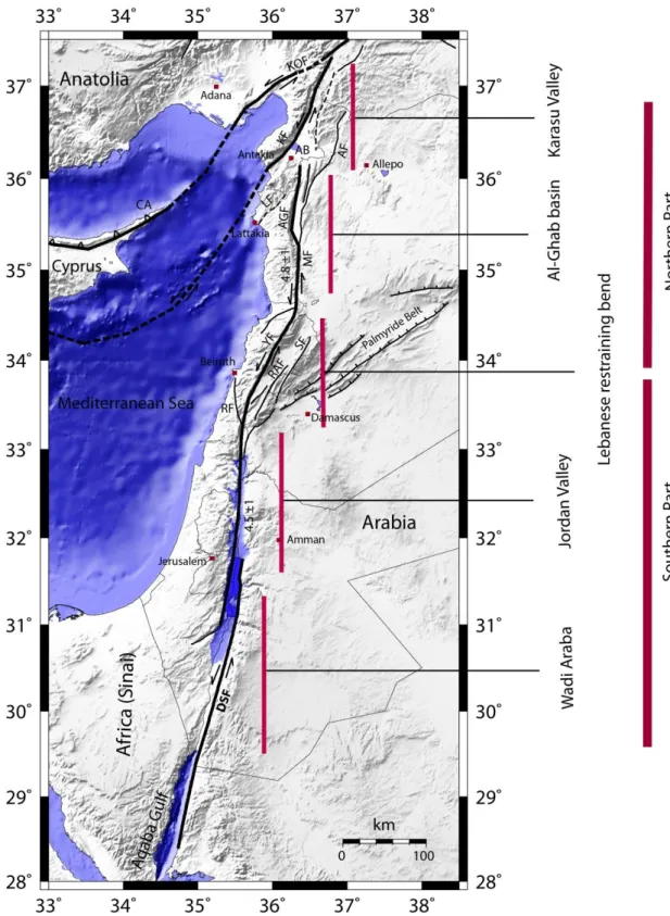
The Dead Sea fault (DSF) is a north-south trending left lateral strike-slip fault (Garfunkel et al., 1981), known as the Levant fault zone and also documented as a transform fault (Wilson, 1965). The DSF forms the limit between the Arabian and African (Sinai) plates and accommodates the northward motion of Arabia in the east relative to the Sinai subplate in the west (Figure I.1). Both plates show a northward movement toward the Eurasia plate with different rates, the Arabian plate rate being about 18-25 mm/yr and the African plate having a slower movement rate of about 10 mm/yr (Reilinger et al., 1997b; McClusky et al., 2000; Reilinger et al., 2006). The DSF extends for about 1000 km and connects the Red sea mid-oceanic ridge (Aqaba Gulf) in the south to the triple junction area to the north in Turkey where it joins the East Anatolian Fault (EAF) and the Cyprus Arc (CA). The DSF consists in N–S trending fault zone that crosses the Dead Sea and links southward through the Gulf of Aqaba and Tiran Strait to the oceanic spreading zone in the Red Sea. The central segment across Lebanon is oriented N308°E, and the northern segment trends N–S across Syria and bends towards NNE showing several small splays (Figure I.1) in southern Turkey (Tatar et al., 2004; Westaway, 2004). A rate of displacement of 2 to 10 mm/yr has been estimated by several geological and geodetic studies along the DSF fault (Freund et al., 1968; Garfunkel et al., 1981; Pe'eri et al., 2002; McClusky et al., 2003; Meghraoui et al., 2003; Wdowinski et al., 2004; Ferry et al., 2007b; Gomez et al., 2007a; Le Béon et al., 2008; Alchalbi et al., 2010).
Geodetic, Geological and geomorphological studies show that the Dead Sea fault does not slip with the same rate along all its segments. We observe a difference in total motion between the south and the north segments of the fault. A total cumulative sinistral slip of about 105 km has been documented along the southern part of the fault (Wadi Araba) and was accumulated during 15 - 20 Ma, when the DSF was initiated in the Middle Miocene (Quennell, 1958; Freund, 1970; Garfunkel, 1981). In the northern part of the fault (Al-Ghab fault, Figure I.1) the total documented amount of slip is 70 – 80 km (Freund, 1970; Dewey et al., 1986; Chaimov et al., 1990; Westaway, 1995; Westaway, 2003), which suggests 25-35 km of slip missed between the north and south of DSF. Several studies had interest to justify this lake of slip. Freund et al., (1970) suggested that some displacement can be transferred a way to the East and west of the main fault throw faults in the Lebanon range (e.g., Serghaya fault, Roum fault, Yammuneh fault), causing this lower displacement along the northern DSF. Chaimov et al., (1990) and Khair et al., (1997) suggest that the shortening on the Palmyride
Chapter I The Dead Sea Fault (DSF)
10
fold belt (20 -30 km) may be also related to the difference in total slip. Furthermore, Yurtmen et al., (2002) noted, that the estimations of total slip in the northern DSF excludes the slip on the Afrin fault that runs east of Amik basin. Other studies (Butler et al., 1998; Butler and Spencer, 1999) suggested that the northern DSF stopped to be active around the Late Miocene and the slip was accommodated by another hypothetical fault zone located offshore to the west along the coast of Syria and Lebanon. In contrast, Brew et al., (2001) and Heimann (2001) suggested that the Northern DSF became active around the Early Pliocene, therefore it shows a smaller amount of total slip.
Chapter I The Dead Sea Fault (DSF)
11
Figure I.1: The Dead Sea fault segments, Fault mapping and slip rates from (Khair et al., 2000; Westaway, 2003; Ferry et al., 2007a; Gomez et al., 2007a; Meghraoui et al., 2011). Abbreviations for some key tectonic features: AGF: Al-Ghab fault, AF: Afrin fault, CA: Cyprus Arc, AB: Amik basin, KF: Karasu fault, KOF: Karatas-Osmaniye fault, LF: Lattakia fault, DSF: Dead Sea fault, EAF: East Anatolian fault, MF: Missyaf fault, SF: Serghaya fault, RF: Roum fault, RAF: Rashaya fault, YF: Yammuneh fault.
Chapter I The Dead Sea Fault (DSF)
12
I.2
Tectonic setting of Dead Sea Fault
I.2.1 General tectonic setting
The Dead Sea Fault (Figure I.1) can be subdivided into the north and the south zone connected to each other by the restraining Lebanese bend an active transpressive zone (Griffiths et al., 2000; Gomez et al., 2003). The main difference between its southern and northern zones is the difference in accumulated slip rate (25 - 35 km) between the north (70 - 80 km) and south (~105 km) of the DSF (Freund, 1970; Chaimov et al., 1990; Westaway, 1995; Westaway, 2003). Khair et al., (2000) divided the DSF into five major segments (Wadi Araba, Jordan Valley, Albeqa’a basin, Al-Ghab Basin and Karasu Valley). The segmentation was proposed due to the difference in geometry, geomorphology, geology and seismicity of each fault zone (Figure I.1). Sbeinati et al., (2010) divided the northern DSF into two main parts: 1) a 90±10 km long linear fault zone which is the Missyaf segment, limited by the Lebanese restraining bend and the Al-Ghab pull-apart basin and 2) the Al-Ghab pull-apart basin of ~10km wide and related complex system of fault branches in its northern termination where it reaches the Amik basin. Another division for the DSF was proposed by Ferry et al., (2011) who considered that the DSF is made of a transtensional system to the south (including the Hula, Dead Sea, and Gulf of Aqaba pull-apart basins), the Lebanese restraining bend (the Yamouneh, Rashaya, Serghaya, and Roum faults) in the middle, and a strike-slip system to the north (the Missyaf fault and the Ghab pull-apart basin). All of these segments have N-S trending in general with small deviation to the NNE for the central and the northern segment of the fault.
In this study, we will focus on the northern part of the Dead Sea fault which connects with the triple junction in south-east of Turkey and north-west of Syria. A detailed investigation of strain accumulation using GPS measurements will be carried out to determine the physical parameters of mapped active faults and understand the kinematics of this part of DSF. Furthermore, the new detailed information and more clear view on the kinematics can be used in the analysis of seismic hazard and risk of the region and have a better assessments.
Chapter I The Dead Sea Fault (DSF)
13
I.2.2 Eastern Mediterranean geodynamics
The present-day geodynamics of the eastern Mediterranean region is controlled by the relative motions of three major plates, Eurasia, Africa, and Arabia (Figure I.2). A large part of deformation in the region is due to the interaction between these plates (Jackson and McKenzie, 1984; Spakman et al., 1988; Westaway, 1994; Le Pichon et al., 1995; Barka et al., 1997; Jolivet and Faccenna, 2000; McClusky et al., 2000; Doglioni et al., 2002; Piromallo and Morelli, 2003; Dilek, 2006; Reilinger et al., 2006). The Anatolian continental block which was a part from Eurasia plate, is acting as a micro plate between these three major plates since the middle Miocene, when it collided with Eurasia (Dewey et al., 1986).
Figure I.2: Map of the eastern Mediterranean region, illustrating the major plates (Africa, Arabia, Eurasia, and Anatolia) and their boundaries and important fault systems. Thick black arrows show the plates convergence directions. Abbreviations for some key tectonic features: EAF: East Anatolian Fault, DSF: Dead Sea Fault, NAF: North Anatolian Fault, PFB: Palmyride Fold Belt, BZFB: Bitlis–Zagros fold and thrust belt. Fault mapping is from (Dilek, 2010). Movement rates are from (McClusky et al., 2003; Reilinger et al., 2006).
The current Anatolian-African plate boundary is represented by a north-dipping subduction zone that has been part of a wide-ranging domain of regional convergence
Chapter I The Dead Sea Fault (DSF)
14
between Eurasia in the north and Africa and Arabia in the south since the late Mesozoic (Faccenna et al., 2003; van Hinsbergen et al., 2005; Jolivet and Brun, 2010). The convergence rate between Africa and Eurasia is greater than 40 mm/yr across the Hellenic Arc but decreases to ~10mm/yr across the Cyprus Arc. Based on plate-tectonic models (NUVEL-1, De Mets et al., 1990) and the global positioning system of present-day central movements in this collision zone (Reilinger et al., 1997b; McClusky et al., 2000; Reilinger et al., 2006), The Arabia-Eurasia convergence is estimated to ~20 mm/yr with NNW trending movement of the Arabia plate relative to Eurasia. This difference in convergence rate between Arabia, Africa and Eurasia can be translated into a slip rate along the Dead Sea fault. The NNW trending convergence of Arabia towards Anatolia produces thickening of the crust in south-eastern Turkey, implying compressional deformation along the Bitlis–Zagros fold and thrust belt (Saroglu and Yilmaz, 1990), and westward extrusion of the Anatolian block. The Anatolian plate is bounded by the dextral NAF and the sinistral EAF (McKenzie, 1972; Sengor, 1979; Sengor et al., 1985; Dewey et al., 1986; McClusky et al., 2000). GPS data indicate a mean extrusion rate for Anatolia, with respect to Eurasia, of about 25 mm/yr along the NAF (Straub and Kahle, 1994; Le Pichon et al., 1995; Straub and Kahle, 1995; McClusky et al., 2000).
I.2.3 Dead Sea Fault segments
I.2.3.1 Wadi Araba
Wadi Araba is the southern part of DSF. It starts from the Red Sea (Aqaba Gulf) at 29.5o N and extends for about 160 km till the Dead Sea basin at 31o N (Figure I.1). This valley is delimited by two plateaus from the east and west, respectively (Klinger et al., 2000b). Along this segment, the fault has a sharp morphological discontinuity that can easily be traced across the Quaternary deposits and alluvium sediments, excluding where the fault is covered with sand dunes or cuts across very recent alluvial terraces. The principal fault is rather straight, striking N20oE, and showing limited structural discontinuities, with a simple geometry reliable with basically pure strike-slip motion (Garfunkel et al., 1981; Klinger et al., 2000b).
The estimations of the slip rate along Wadi Araba segment are varying between 2.5 and 7.5 mm/yr. An estimation based on geodesic study (GPS) of 4.9±1.4 mm/yr was given by (Le Béon et al., 2008), this value relays on 6 years of time span and a locking depth of 12 km. Geodetic studies along this segment and other segments are described in details in paragraph (1.4.2.2), see Table I.3.
Chapter I The Dead Sea Fault (DSF)
15
Regarding the historical catalogues, a few seismic events are reported during the last 2000 years along the Wadi Araba. The biggest reported events occurred in AD 1068, 1212, 1293 and 1458 (Abou Karaki, 1987; Ambraseys et al., 1994; Klinger et al., 2000b). These events seems to be smaller than the 1995 earthquake which struck the Aqaba Golf with a Mw~7.3 (Klinger et al., 1999) due to lack of seismicity and elapsed time since the most recent historical earthquakes which suggest that a tectonic loading has been accumulating along the fault (Ferry et al., 2011).
I.2.3.2 Jordan Valley
The trending N-S Jordan Valley extends ~180 km between the Dead Sea pull-apart basin at 30.7o N and the Hula Basin in the north before connecting with the Lebanese restraining bend at 33.1o N. The northern end of this segment attests on the division of the DSF into many fault branches trending toward the NNE, the Serghaya, Rashaya, Hasbaya, and Yammuneh faults (Figure I.1). This segment is connecting the two pull-apart basins of the Dead Sea and the Tabariya and was the object of paleoseismologic and geomorphologic studies which estimate its slip rate a 2.5 to 10 mm/yr (Marco et al., 1997; Galli, 1999). One of the last recent studies along Jordan Valley (Ferry et al., 2011) proposes a slip rate of 5 mm/yr. This study relies on paleoseismic, archaeoseismologic and historical data for 12 destructive earthquakes over the last 25 kyr.
The calculated average magnitude for the paleoearthquakes in the Jordan Valley segment is Mw 6.6 (Hamiel et al., 2009). However, Ferry et al., 2011 suggests that the length of fault segments and thickness of the seismogenic crust agree with Mw 7.2-7.4 as a reasonable maximum magnitude in the region. Studies of macroseismic damage from historical events and archaeological evidence conclude that 1–3 large earthquake (Ms>6) occurred in the northern Jordan Valley segment during the past 2000 yr (Ambraseys et al., 1994; Guidoboni et al., 1994; Marco et al., 2003).
I.2.3.3 Beqa’a Basin (Lebanese restraining bend)
The 200-km-long Lebanese restraining bend between 33.1o N and 34.7o N is the central part of the Dead Sea fault in Lebanon and southwestern Syria. This segment strikes 25◦–30◦ from the main trend of the transform fault (Gomez et al., 2007a). It shows NNE trending fault branches, i.e., the Serghaya, Rashaya, Hasbaya, and Yammuneh Faults and NW trending Al-Roum Fault in the south and the SE Akkar fault in the north. The Yamouneh
Chapter I The Dead Sea Fault (DSF)
16
Fault forms the main fault continuation on the Dead Sea Fault to the North and ends at the Lebanese border where the NS section starts in Syria. Al-Roum and Akkar faults are striking oblique to the DSF transform. They seems to serve as the structure linkages between the strike-slip faults of the Lebanese restraining bend and the horizontal shortening of the mountain Lebanon range (Gomez et al., 2006; Nemer and Meghraoui, 2006; Gomez et al., 2007a).
Recent geodesic studies gave a slip rate of 4-5 mm/yr along the main Yamouneh fault (Mahmoud et al., 2005; Reilinger et al., 2006; Gomez et al., 2007a). Other geomorphologic studies propose a slip rate of 5-10 mm/yr (Garfunkel et al., 1981; Daeron et al., 2004a). The historical seismicity of this segment being rich with several historical large events contradicts with the recent time of a general seismic quiescence. The large earthquakes that took place in the Lebanese restraining bend are 551 AD, 1202 AD, 1759 AD and 1837 AD (Ambraseys and Melville, 1988; Ambraseys and Barazangi, 1989; Beydoun, 1997; Sbeinati et al., 2005).
I.2.3.4 Al-Ghab basin
This segment is NS trending and extends along 150 km between 34.7oN and 35.9oN in the NW of Syria (Figure I.1). It is adjacent to the coast range (Brew et al., 2001); it extends from Lebanon to the south of Turkey where it joins the Karasu Valley. This part of the DSF has three main sub-segments from south to north: the Missyaf segment as single linear fault structure; the Al-Ghab fault zone and pull-apart region divides into several fault branches with the main Jisser Al-Shoughur segment west of the basin and the Afamia and Afrin faults to the east of the basin (Sbeinati, 2010). Previous geodetic studies have moderated the slip rate of this DSF segment, most of them determined almost the same rate (4.2 – 4.8 mm/yr) (Mahmoud et al., 2005; Reilinger et al., 2006; Gomez et al., 2007a). (Alchalbi et al., 2010) has proposed a smaller value of 1.8-3.3 mm/yr, this last value have the largest time span (~7.5 year) among the other similar studies. Other archaeoseismologic studies give a slip rate of 5-6.9 mm/yr.
This segment has experienced a considerable historical seismicity. Several large seismic events (with M > 7) took place along the Missyaf fault and the others branches to the north like 859AD, 1349 AD, 1157AD, 1170 AD, 1202AD and 1408AD (Ambraseys and Melville, 1988; Meghraoui et al., 2003; Sbeinati, 2010).
Chapter I The Dead Sea Fault (DSF)
17
The northern DSF, in Syria and southern Turkey, is regarded as a series of transpressional stepovers, along which the left-lateral slip is apparently slower than the relative plate motion, because this slip is oblique to the relative plate motion (Gomez et al., 2007).
I.2.3.5 Karasu Fault
The Karasu fault limits the northernmost segment of the left lateral DSF and extends for 150 km along the Karasu valley in south east Turkey, between 35.9o N and 37.1o N. At this segment, the fault changes its striking direction and continues to the NE. The Karasu Fault joins the southern end of the left lateral East Anatolian fault and the Cyprus arc extension in the north of the valley (Figure I.1). This valley is tectonically complex because of the existence of many small fault segments in the region and it accommodates the deformations of the triple point junction between the Arabia, Africa and Eurasia plates. Previous historical studies show that this segment was the source of many large earthquakes in the past, like the 859AD, 1822AD and 1872AD with M>7 (Sbeinati et al., 2005).
I.3
Seismicity of Dead Sea Fault
I.3.1 Historical seismicity
The Middle East is one of the oldest inhabited regions of the world and by consequence it has among the richest written history on earthquakes. The earthquakes as any other well-known natural events were recorded and described carefully. The old documents describe the earthquakes effects on nature and man-made structures, such as faulting rupture, co-seismic deformation, landslide, springs appearing and disappearing, lives losses, houses destruction, ... etc. This allows us to have, nowadays, a very rich earthquake catalogue for more than 3000 year in the Middle East region (Ambraseys et al., 1994; Ambraseys and Jackson, 1998; Sbeinati et al., 2005; Ambraseys, 2009b).
Seismic activity of the DSF has been measured for different magnitudes and timescales: that is tens of thousands of years (Marco et al., 1996; Amit et al., 2002; Begin et al., 2005), thousands of years (Zilberman et al., 2005), hundreds of years (Migowski et al., 2004), and decades (Salamon et al., 2003). These studies have shown that the eastern Mediterranean Sea region was strongly affected by large historical seismic events where
Chapter I The Dead Sea Fault (DSF)
18
many medieval cities, fortresses, citadels or known archaeological sites were damaged or destroyed by earthquakes. A very good example of large seismic activities along the Dead Sea fault is the event of May 20, 1202 of Ms >7.5 and I = X (Daeron et al., 2004) which has been felt over long distances from Egypt to Greece and Iran (Ambraseys et al., 1994). The earthquake revealed surface ruptures and destroyed a large part of Lebanon and surrounding areas and led to an unprecedented decline in social structures and the local economy. Other earthquakes have struck ancient cities such as Antakya in Turkey, Apamea and Aleppo in Syria, Baalbek in Lebanon and Jarash in Jordan. The traces of these historical events are clearly visible on these sites by the presence of walls damaged or destroyed crumbled and columns. This impressive wealth of archaeological sites and cultural rights is an open archive to study the ancient and historical earthquakes.
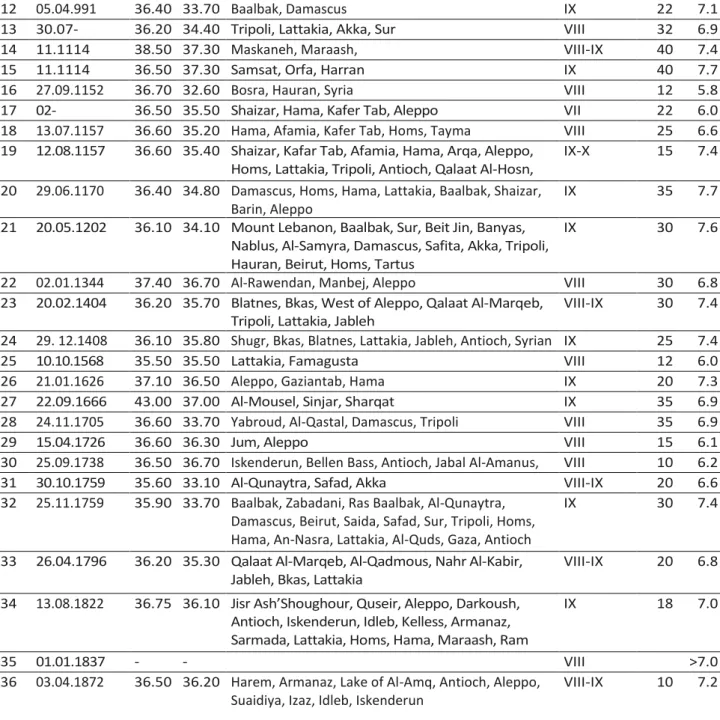
Sbeinati et al.,(2005) has prepared a historical earthquake catalogue of Syria and neighboring regions where large shocks are represented in Table I.1 and shows the parameters of the destructive historical earthquakes estimated from the textual descriptions of events damage. The catalogue is presented as a list of earthquakes with its parameters ordered by date, time, epicenter, coordinates, estimated maximum intensity, calculated magnitude, intensity at affected localities, and the natural co-seismic features. The historical catalogue of Sbeinati et al., (2005) extends up to 1365 B.C. and contains important information on the occurrence of large earthquakes. Even though the low level of instrumental seismicity and the absence of strong motion records, seismic parameters and fault activity along the Dead Sea Fault related to the historical earthquake data has an important role in estimating the seismic hazard for the region.
No Date (dd.mm.yyyy)
Long. (E°)
Lat.
(N°) Major affected localities
I0 (EMS-92)
H (km) Ms
1 37 A.D. 36.30 36.00 Antioch, Dafneh VII-VIII 15 6.2 2 53 36.50 36.20 Antioch, Afamia, Manbej, Lattakia VIII 30 6.6 3 303-304 34.30 33.80 Saida, Sur, Syria VIII-IX 20 7.1 4 494 36.30 35.80 Antioch, Tripoli, Lattakia VII-VIII 25 6.5 5 22.08.502 34.80 33.00 Akka, Sur, Saida, Beirut, Safad VIII-IX 30 7.2 6 531-534 37.20 35.50 Area between Aleppo and Homs VIII 15 6.5 7 09.07.55 1 35.50 34.00 Cities of Lebanese coast, Arwad IX-X 28 7.2 8 565-571 36.20 36.00 Antioch, Seleucea, Kilikia, Anazrabo VII-VIII 30 6.0 9 18.01.747 35.60 32.50 Mt. Tabor, Baalbak, Bosra, Nawa, Balqa, Al-Quds,
Beit Qubayeh, Tabaryya, Damascus, Daraa
IX 25 7.2 10 24.11.847 36.30 34.40 In and around Damascus, Antioch, Al-Mosel IX 35 7.5 11
30.12.859-29.01.860
36.40 35.70 Antioch, Lattakia, Jableh, Homs, Palmyra, Tarsus, Balis, Damascus, Adana, Ar-Raqqa
Chapter I The Dead Sea Fault (DSF)
19
12 05.04.991 36.40 33.70 Baalbak, Damascus IX 22 7.1 13
30.07-27.08.1063
36.20 34.40 Tripoli, Lattakia, Akka, Sur VIII 32 6.9 14 11.1114 38.50 37.30 Maskaneh, Maraash, VIII-IX 40 7.4 15 11.1114 36.50 37.30 Samsat, Orfa, Harran IX 40 7.7 16 27.09.1152 36.70 32.60 Bosra, Hauran, Syria VIII 12 5.8 17
02-04.04.1157
36.50 35.50 Shaizar, Hama, Kafer Tab, Aleppo VII 22 6.0 18 13.07.1157 36.60 35.20 Hama, Afamia, Kafer Tab, Homs, Tayma VIII 25 6.6 19 12.08.1157 36.60 35.40 Shaizar, Kafar Tab, Afamia, Hama, Arqa, Aleppo,
Homs, Lattakia, Tripoli, Antioch, Qalaat Al-Hosn, Maarret Annooman
IX-X 15 7.4 20 29.06.1170 36.40 34.80 Damascus, Homs, Hama, Lattakia, Baalbak, Shaizar,
Barin, Aleppo
IX 35 7.7 21 20.05.1202 36.10 34.10 Mount Lebanon, Baalbak, Sur, Beit Jin, Banyas,
Nablus, Al-Samyra, Damascus, Safita, Akka, Tripoli, Hauran, Beirut, Homs, Tartus
IX 30 7.6
22 02.01.1344 37.40 36.70 Al-Rawendan, Manbej, Aleppo VIII 30 6.8 23 20.02.1404 36.20 35.70 Blatnes, Bkas, West of Aleppo, Qalaat Al-Marqeb,
Tripoli, Lattakia, Jableh
VIII-IX 30 7.4 24 29. 12.1408 36.10 35.80 Shugr, Bkas, Blatnes, Lattakia, Jableh, Antioch, Syrian
coast
IX 25 7.4 25 10.10.1568 35.50 35.50 Lattakia, Famagusta VIII 12 6.0 26 21.01.1626 37.10 36.50 Aleppo, Gaziantab, Hama IX 20 7.3 27 22.09.1666 43.00 37.00 Al-Mousel, Sinjar, Sharqat IX 35 6.9 28 24.11.1705 36.60 33.70 Yabroud, Al-Qastal, Damascus, Tripoli VIII 35 6.9 29 15.04.1726 36.60 36.30 Jum, Aleppo VIII 15 6.1 30 25.09.1738 36.50 36.70 Iskenderun, Bellen Bass, Antioch, Jabal Al-Amanus,
Aleppo
VIII 10 6.2 31 30.10.1759 35.60 33.10 Al-Qunaytra, Safad, Akka VIII-IX 20 6.6 32 25.11.1759 35.90 33.70 Baalbak, Zabadani, Ras Baalbak, Al-Qunaytra,
Damascus, Beirut, Saida, Safad, Sur, Tripoli, Homs, Hama, An-Nasra, Lattakia, Al-Quds, Gaza, Antioch
IX 30 7.4
33 26.04.1796 36.20 35.30 Qalaat Al-Marqeb, Al-Qadmous, Nahr Al-Kabir, Jableh, Bkas, Lattakia
VIII-IX 20 6.8 34 13.08.1822 36.75 36.10 Jisr Ash’Shoughour, Quseir, Aleppo, Darkoush,
Antioch, Iskenderun, Idleb, Kelless, Armanaz, Sarmada, Lattakia, Homs, Hama, Maraash, Ram Hamadan, Bennesh, Maarret Missrin Safad
IX 18 7.0
35 01.01.1837 - - VIII >7.0
36 03.04.1872 36.50 36.20 Harem, Armanaz, Lake of Al-Amq, Antioch, Aleppo, Suaidiya, Izaz, Idleb, Iskenderun
VIII-IX 10 7.2
Table I-1: Main destructive earthquakes with Ms > 5.9 along the Dead Sea Fault (Sbeinati et al., 2005).
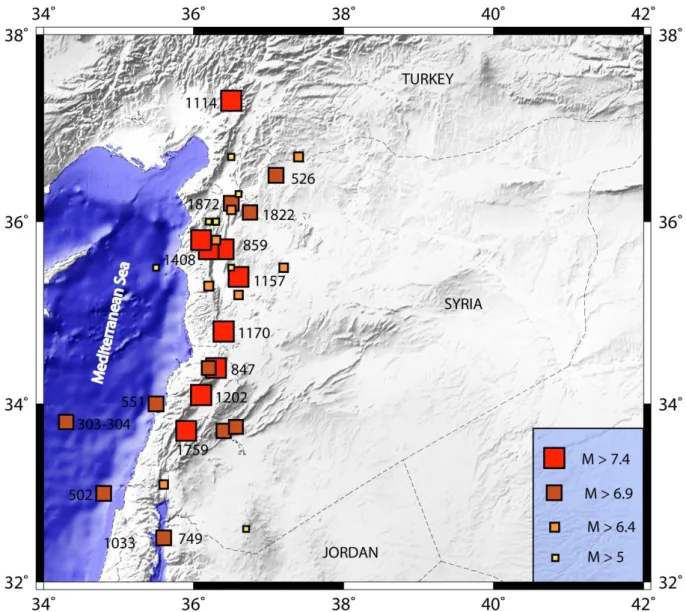
Most of studies referring to historical earthquakes confirm that almost all of them are associated with a sinistral surface rupture. Figure I.3 shows the historical earthquakes of magnitude greater than 5 associated with the Dead Sea Fault in Syria from 37 A.D. to 1900 A.D. Sbeinati (2010). A repetition of seismic events matching to those of the past, nowadays, will cause enormous damage, because of the increase of modern buildings and the population during the last century.
Chapter I The Dead Sea Fault (DSF)
20
Figure I.3: Map of historical seismicity in Lebanon, Syria and southern Turkey with magnitude greater than 5 from 37 A.D. to 1900 A.D. Data from Table I.1.
Chapter I The Dead Sea Fault (DSF)
21
I.3.2 Instrumental seismicity
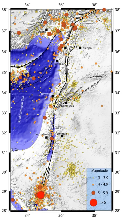
The Dead Sea fault shows a relatively moderate instrumental seismicity with most events of a low magnitude, typically ~M=4.5.
The southern parts (Wadi Araba and Jordan Valley) of the Dead Sea Fault system recorded the only two major instrumental earthquakes: The first event occurred in July 11, 1927 (M = 6.2) along the Jordan Valley. The second event, which is the larger instrumental event recorded along the DSF, took place in November 22, 1995 (Mw = 7.3; Figure I.4) in the Gulf of Aqaba. Its magnitude is comparable to the historical earthquakes of the region like the 1068 and 1212 earthquakes (Abou Karaki, 1987; Ambraseys et al., 1994; Zilberman et al., 2005). The earthquake has produced about 2.1 m total displacement of left lateral slip along the 56 km long and trending N20oE fault segment (Klinger et al., 1999). This earthquake was followed by an intense aftershock activity for about 6 months. Despite these two large instrumental events, the Dead Sea Fault instrumental seismicity is lower than the historical seismic activity throughout the last 1000 years or so, which leads us to conclude that the present-day period is a seismic gap.
Figure I.4 shows the instrumental seismicity (M> 3) recorded along the DSF from 1976 to 2011, Earthquakes swarms are located in the Gulf of Aqaba, Lebanon, south of Cyprus and the near to junction with the EAF. Figure I.5 shows the Harvard CMT focal mechanism solutions of earthquakes of magnitude greater than 4.5 between 1976 to January 2011 along the Dead Sea fault zone.
Chapter I The Dead Sea Fault (DSF)
22
Figure I.4: Instrumental seismicity of the Dead Sea fault between 1964 and 2011, M>3. Data are from: IRIS (Incorporated Research Institutions for Seismology, http://www.iris.edu/hq/), ISC (The International Seismological Center, http://www.isc.ac.uk/) and NEIC (The National Earthquake Information Center, http://earthquake.usgs.gov/regional/neic/). Mapped faults are from Meghraoui et al., (2011) and Ferry et al., (2007).
Chapter I The Dead Sea Fault (DSF)
23
Figure I.5: Focal mechanism of earthquakes between 1976 and 2011 along the Dead Sea Fault, of magnitude greater than 4.5. Data are from catalogues Harvard CMT. Mapped faults are from Meghraoui et al., (2011) and Ferry et al., (2007).
Chapter I The Dead Sea Fault (DSF)
24
I.4
Kinematisc of Dead Sea Fault
I.4.1 Geodynamic of the Dead Sea Fault
The slip rate on the Dead Sea fault has been determined by various methods, including geology, geomorphology, seismology, paleoseismology (Table I.2) and geodesy (Table I.3). The slip rate is estimated between 2 and 8 mm/yr depending on the time scale of observations and studied fault segment.
I.4.1.1 Long term deformation
Estimates of the slip rate based on the geology is using a total shift along the geological fault during a known period to determine an average rate of displacement associated with this fault. Geological observations of the last 15-20 Myr indicate a slip rate of 2-10 mm/yr (Quennell, 1958; Freund et al., 1968; Freund, 1970; Garfunkel et al., 1981).
The geomorphological estimations of left lateral slip are mainly based on measurements of geomorphic markers such as alluvial fans, terraces, waterways, etc.., across the fault during a specified period, and then dated by isotopic dating. Accordingly, Klinger et al., (2000a, 2000b) suggest along the Wadi Araba segment a slip rate of 2 to 6 mm/yr (for a period of 77 to 140 ka), while Ginat et al., (1998) proposes 3 to 7.5 mm/yr (Pleistocene) and Niemi et al., (2001) propose 3.4 to 6 mm/yr (15 kyr). Using offsets of drainage systems surveyed at three sites of the southern segment of DSF, Ferry et al., (2007) propose an average constant slip rate of 4.7-5.1 mm/yr for the last 47.5 Kyr. Galli (1999) gives a value of 10 mm/yr for south of the Dead Sea fault for the last 18 to 70kyr. Zange (1998) noted the offsets of rivers and alluvial fans surfaces of 39 m and 22.5 m, respectively. These offsets have been dated between 8500 and 4700 years and give a slip rate of 4.6 to 4.8 mm/yr for this period. The geomorphological approach was also applied by Garfunkel et al., (1981) on a basalt offset measured at 8 km north of Lebanon. They estimate a slip rate of 5 to 10 mm/yr along the Yammuneh fault during the Pleistocene. This value is in agreement with the study of Daeron et al., (2004a), which correlate the offset of two alluvial fans with distance of 50 km along the Yammuneh fault in Lebanon and estimate a slip rate of 5.1±1.3 mm/yr during the late Pleistocene - Holocene. As mentioned before, Ferry et al., (2011) used paleoseismic data with 28 radiocarbon datings and archaeoseismology at Tell Saydiyeh, supported by a rich historical seismic records, he documented 12 destructive events along the Jordan Valley
Chapter I The Dead Sea Fault (DSF)
25
segment with a mean interval of ~1160 yr and an average 5 mm/yr slip rate for the last 25 kyr. These results agree with Ferry et al., (2007).
Estimates of the slip rate based on seismicity use the historical and instrumental data to calculate an average return period of major earthquakes and deduce an average slip rate. Garfunkel et al., (1981) estimate a seismic slip-rate between 1.5 and 3.5 mm/yr for the last 1000 to 1500 years on the Dead Sea Fault based on instrumental and historical records. For the segment of Wadi Araba, Klinger et al., (1999) propose a slip rate of 4±2 mm/yr for the last 2000 years, using a maximum 8 m co-seismic displacement for the 1995 earthquake.
Fault
segment Evidence type
Amount of
offset Age of datum
Slip rate
mm/yr Authors
DSF (general)
Geol. 65 km ~4Ma ~ 8.7 Westaway et al., 2001
7–10 Ma 4–6 Freund et al., 1970
3.1–3.7 Ma 9–15 Steinitz et al., 1978 Pliocene-Pleistocene
(4–5 Ma) 7–10 Garfunkel et al., 1981 Last 1,000–1,500 yr 1.5–3.5 Garfunkel et al., 1981 Offset Miocene rocks 40–45 km 7–12 Ma 3.5–6 Freund et al., 1968
Amik basin Paleo 7.9 km Pre-Quaternary 4.94±0.13 Karabacak 2009
Paleo 42 m 6500 BC 6.07 Altunel et al., 2009
Paleo 25 m 1500 BC 6.07 Altunel et al., 2009
Missyaf & Al-Ghab
Paleo. 13.6 m Last 2000 years 6.9±0.1 Meghraoui et al., 2003
Paleo 13.6 m 3000 years 4.9-6.3 sbeinati et al., 2010
Yammuneh Offset alluvial fans 25 ka 5.1±1.3b Daëron et al., 2004 Offset Homs basalts 8 km Miocene- Pliocene 5–10
Offset Litani river 5 km 1–2 Ma 5–10 Garfunkel et al., 1981
Offset alluvial fans ~25 kyr 5.1±1.3 Daeron et al., 2004
Roum Paleo 0.86 – 1.05 Nemer et al., 2006
Serghaya Offset channels 10 ka 1.4±0.2 Gomez et al., 2003
Hula Basin Offset of walls 2.1 m Holocene (817 year) ~ 2.5 Marco et al., 1997
Jordan valley Geol. offset gullies the last 47.5 kyr 4.7 to 5.1 Ferry et al., 2007
Paleo. Offset drainage Last 25 kyr 5 Ferry et al., 2011
Paleo Last 5 kyr 3 – 4 Marco et al., 2005
Offset channels 100–150 m post-Lisan 10 Garfunkel et al., 1981
Paleo 60,000 yr 0.5 Hamiel et al., 2009
Wadi Araba Offset gullies and fan surfaces on ributaries to
Wadi Dahal
54 m 16–11 ka 3.4–4.9
39 m 9–6.5 ka 4.3–6.0