HAL Id: hal-02991649
https://hal.archives-ouvertes.fr/hal-02991649
Submitted on 6 Nov 2020HAL is a multi-disciplinary open access archive for the deposit and dissemination of sci-entific research documents, whether they are pub-lished or not. The documents may come from teaching and research institutions in France or abroad, or from public or private research centers.
L’archive ouverte pluridisciplinaire HAL, est destinée au dépôt et à la diffusion de documents scientifiques de niveau recherche, publiés ou non, émanant des établissements d’enseignement et de recherche français ou étrangers, des laboratoires publics ou privés.
The influence of bottom currents on the Zambezi Valley
morphology (Mozambique Channel, SW Indian Ocean):
In situ current observations and hydrodynamic
modelling
Elda Miramontes, Pierrick Penven, Ruth Fierens, Laurence Droz, Samuel
Toucanne, Stephan J. Jorry, Gwenael Jouet, Lucie Pastor, Ricardo Silva
Jacinto, Arnaud Gaillot, et al.
To cite this version:
Elda Miramontes, Pierrick Penven, Ruth Fierens, Laurence Droz, Samuel Toucanne, et al.. The influence of bottom currents on the Zambezi Valley morphology (Mozambique Channel, SW Indian Ocean): In situ current observations and hydrodynamic modelling. Marine Geology, Elsevier, 2019, 410, pp.42-55. �10.1016/j.margeo.2019.01.002�. �hal-02991649�
See discussions, stats, and author profiles for this publication at: https://www.researchgate.net/publication/330390073
The influence of bottom currents on the Zambezi Valley morphology
(Mozambique Channel, SW Indian Ocean): In situ current observations and
hydrodynamic modelling
Article in Marine Geology · January 2019
DOI: 10.1016/j.margeo.2019.01.002 CITATIONS 13 READS 690 12 authors, including:
Some of the authors of this publication are also working on these related projects:
PAMELA projectView project
CONGOLOBEView project Elda Miramontes Universität Bremen 27PUBLICATIONS 147CITATIONS
SEE PROFILE
Pierrick Penven
Institute of Research for Development 101PUBLICATIONS 4,244CITATIONS
SEE PROFILE Ruth Fierens
Université de Bretagne Occidentale 8PUBLICATIONS 20CITATIONS
SEE PROFILE
L. Droz
French National Centre for Scientific Research 147PUBLICATIONS 2,506CITATIONS
SEE PROFILE
All content following this page was uploaded by Elda Miramontes on 16 January 2019. The user has requested enhancement of the downloaded file.
1
The influence of bottom currents on the Zambezi Valley morphology (Mozambique
1
Channel, SW Indian Ocean): in situ current observations and hydrodynamic modelling
2
Elda Miramontesa, Pierrick Penvenb, Ruth Fierensa, Laurence Droza, Samuel Toucannec, Stephan J.
3
Jorryc, Gwenael Jouetc, Lucie Pastord, Ricardo Silva Jacintoc, Arnaud Gaillotc, Jacques Giraudeaue,
4
François Raissonf
5
aUMR 6538 CNRS-UBO, IUEM, Laboratoire Géosciences Océan, 29280 Plouzané, France.
6
b UMR 6523 CNRS, IFREMER, IRD, UBO, Laboratoire d’Océanographie Physique et Spatiale, Plouzané
7
29280, France. 8
c IFREMER, Géosciences Marines, Centre de Brest, 29280 Plouzané, France.
9
d IFREMER, Laboratoire Environnement Profond, Centre de Brest, 29280 Plouzané, France.
10
e EPOC, UMR 5805, Université de Bordeaux, CNRS, 33615, Pessac CEDEX, France.
11
f TOTAL, R&D Frontier Exploration program, 64000 Pau, France.
12
Corresponding author: Elda Miramontes (Elda.Miramontesgarcia@univ-brest.fr) 13
14
Abstract 15
Mixed turbidite-contourite systems can be found in oceans where bottom currents and turbidity 16
currents interact. The Zambezi turbidite system, located in the Mozambique Channel (SW Indian 17
Ocean), is one of the largest sedimentary systems in the world in length and area of the related 18
catchments. The oceanic circulation in the Mozambique Channel is intense and complex, dominated 19
by eddies flowing southwards and deep currents flowing northwards along the Mozambican margin. 20
Current measurements obtained from moorings at 3400-4050 m water depth in the Zambezi and 21
Tsiribihina valleys show periods of intense currents at the seafloor with peaks of 40-50 cm s-1 that last
22
up to one month and are not related to turbidity currents. These strong bottom-current events are 23
correlated with a change in current direction and an increase in temperature. The periods of current 24
intensification may be related to eddies, since they present similar frequencies (around 7 per year). 25
Moreover, modelling results show that during periods of intense deep circulation an anticyclonic 26
2 eddy is present between the Mozambican slope and the centre of the Mozambique Channel, which 27
may block the northward transport of the deep water mass and thus enhance the southward 28
transport along the western slope of Madagascar. According to our hydrodynamic modelling of the 29
circulation near the seafloor, intense currents are often present along the Zambezi Valley, especially 30
along the valley flanks. Multi-channel seismic reflection data show that the Zambezi turbidite system 31
does not show the typical characteristics of turbidite systems, being dominated by erosional 32
processes, which mainly affect the valley flanks. Levees associated with the valley are absent in the 33
main axis of the system. The effect of bottom currents on sedimentation in the basin is evidenced by 34
the low sedimentation rates that witness winnowing in the basin, the presence of contouritic sand in 35
the Zambezi Valley flanks and the abundance of current-related bedforms observed in multibeam 36
bathymetry and seismic data. The intense oceanic processes observed in the Mozambique Channel 37
may transport a large part of the fine sediment out of the basin and erode the seafloor even at great 38
depths. Therefore, the Zambezi turbidite system could at present be considered as a mixed turbidite-39
contourite system, with important implications for source-to-sink studies. 40
41
Keywords 42
Contourite; Turbidity current; Mixed system; Oceanic circulation; Mooring; ADCP; ROMS model; 43 Bedform 44 45 1. Introduction 46
The effect of oceanic currents on sediment transfer from the continent to the deep sea has been 47
widely recognised on the continental shelves (e.g., Sømme et al., 2009; Covault et al., 2011). 48
However, in source-to-sink studies, the effect of bottom currents in deep-sea settings has not often 49
been taken into consideration (Calvès et al., 2013). The source-to-sink system is commonly divided 50
into different segments: catchment, continental shelf, slope and basin floor (Sømme et al., 2009; 51
Helland-Hansen et al., 2016; Romans et al., 2016). This vision of the continent-basin transition as a 52
3 continuum does not take into account the complexity and intensity of the oceanic circulation. 53
Bottom currents can generate, for instance, erosion on the slope with the formation of contouritic 54
terraces dominated by erosional processes and coarse-grained sediment (Hernández-Molina et al., 55
2016; 2017), or alongslope redistribution of the sediment carried by turbidity currents (Mulder et al., 56
2008). Therefore, in order to take the effect of oceanic circulation on basin sedimentation into 57
account, it is necessary to perform 3D studies of the sedimentary processes acting across- and 58
alongslope. 59
All turbidite systems can potentially be affected by geostrophic currents because these occur along 60
continental margins worldwide. However, when the energy of sediment gravity flows is high, the 61
influence of bottom currents may become insignificant. Mixed contourite-turbidite systems are 62
developed where bottom currents and gravity-driven processes occur in the same area and have 63
similar energy, resulting in modifications of the sediment body morphology or in alternations of 64
contourites and turbidites (Mulder et al., 2008). 65
Bottom currents are often considered as permanent steady flows, in contrast to the more episodic 66
nature of gravity-flows (Rebesco et al., 2014). Nevertheless, both short-term and seasonal variations 67
may also be involved in controlling the formation of sediment drifts (Zhang et al., 2016; Thran et al., 68
2018). More studies based on in situ current measurements and hydrodynamic modelling are needed 69
to better understand the intensity and variability of bottom currents and their effect on deep-sea 70
sedimentation. In order to provide new insights on this topic, we aim to: (i) analyse intensity and 71
temporal variability of the bottom circulation in the Mozambique Channel; and (ii) decipher the 72
impact of such circulation on the development of the Zambezi turbidite system, by comparing the 73
observed and modeled current patterns with the resulting morphology. We used a multidisciplinary 74
approach that integrates multibeam bathymetry, seismic reflection data, sediment cores, mooring 75
data (current velocity, temperature and sediment trap) and hydrodynamic modelling. 76
77 78
4 2. Regional setting
79
2.1. Geological setting 80
The Mozambique Channel is an elongate, north-south oriented basin, located in the Southwest 81
Indian Ocean between the African continent and Madagascar. Its depth ranges between 2700 m in 82
the north at the narrowest part of the channel and 5000 m in the southern part of the channel (Fig. 83
1A). The Mozambique Channel developed during the breakup of Gondwana in the Early Jurassic-Early 84
Cretaceous (Mahanjane, 2014; and references therein). A group of modern isolated carbonate 85
platforms is located in the middle of the channel, which includes Bassas da India and Europa (Jorry et 86
al., 2016; Fig. 1B). The study of seamounts at the vicinity of the modern reef has shown that 87
carbonates started to settle on volcanic edifices during Oligocene-Miocene times (Courgeon et al., 88
2016). 89
The sedimentary deposits in the Mozambique Channel are bounded in the north and west by the 90
Mozambican margin, and in the east by the Madagascar margin and the Davie Ridge (Castelino et al., 91
2017). The Zambezi is the main river delivering sediment to the basin, which, with a catchment area 92
of 1.4·106 km2 (Walford et al., 2005), is one of the largest fluvial systems in SE Africa. However, some
93
sediment is also supplied from Madagascar, for instance from the Tsiribihina river (Fig. 1B). The 94
modern Zambezi turbidite system started to develop at the beginning of the Oligocene (Droz and 95
Mougenot, 1987). It is composed of two main valleys, the Zambezi Valley originating from the 96
Mozambican margin and the Tsiribihina Valley, which is a tributary originating from the Madagascar 97
margin (Figs. 1B and 2). At present the Zambezi submarine system is not directly connected to the 98
river system (Schulz et al., 2011). The sediment is mainly dispersed by alongshore currents on the 99
continental shelf during sea level high-stands (Schulz et al., 2011; Wiles et al., 2017a). 100
101
2.2. Oceanographic setting 102
The oceanic circulation in the Mozambique Channel is very complex and intense. It forms part of the 103
greater Agulhas Current system that extends from north of Madagascar to South Africa (Fig. 1A; 104
5 Lutjeharms, 2006). The Agulhas Current is the strongest western-boundary current in the southern 105
hemisphere, and it is an important link in the heat and salt exchange between the Indian and the 106
Atlantic Oceans (Gordon, 1986; Weijer et al., 1999). Currents in the Mozambique Channel comprise a 107
southward-bound, western boundary current (Mozambique Current, MC) (DiMarco et al., 2002; 108
Quartly et al., 2013; Flemming and Kudrass, 2018) and anticyclonic eddies with diameters of≥300 109
km, that flow southwards and can affect the whole water column (Fig. 1A; de Ruijter et al., 2002; 110
Halo et al., 2014). The frequency of the eddy passage is about four to seven per year (Schouten et al., 111
2003). Eddies trap anomalous water masses with higher nutrient and lower oxygen concentrations 112
(Swart et al., 2010), advect coastal waters with high phytoplankton biomass into the offshore oceanic 113
environment (Tew-Kai and Marsac, 2009), and may also transport sediment in suspension as 114
observed in the South China Sea (Zhang et al., 2014). The formation of eddies in the Mozambique 115
Channel is related to the South Equatorial Current (SEC) (Fig. 1A; Schott et al., 2009). The SEC splits 116
near 17°S into two branches, the Northeast and Southeast Madagascar Currents (NEMC and SEMC) 117
(Fig. 1A; Schott et al., 2009). 118
The upper layers of the Mozambique Channel are composed of the Tropical Surface Water (TSW) at 119
the surface and the Subtropical Surface Water (STSW) in the subsurface. The permanent thermocline 120
is mainly composed of South Indian Central Water (SICW) (Figs. 1C, D). Intermediate waters in the 121
Mozambique Channel are composed of Red Sea Water (RSW), that enters into the Mozambique 122
Channel from the north, and Antarctic Intermediate Water (AAIW), that enters from the south as 123
part of the Mozambique Undercurrent (MUC) (Fig. 1; Ullgren et al., 2012). The deep waters in the 124
Mozambique Channel contain North Atlantic Deep Water (NADW) and Antarctic Bottom Water 125
(AABW) (Figs. 1C, D; van Aken et al., 2004; Ullgren et al., 2012). The NADW is found between about 126
2000 and 3500 m water depth (wd) and the AABW at more than 3500 m wd (Figs. 1C, D). The NADW 127
is characterised by a relative maximum in salinity and oxygen at about 2500 m wd (Fig. 1D; Mantyla 128
and Reid, 1995). The upper portions of the NADW and the AAIW flow, as the Mozambique 129
Undercurrent (MUC), northwards along the western margin of the basin through the sill of the 130
6 Mozambique Channel (Fig. 1A; van Aken et al., 2004; Ullgren et al., 2012). The deep portion of the 131
NADW and the AABW (characterised by an absolute minimum of temperature and a relative 132
minimum of salinity; Fig. 1D) are constrained by the bathymetry, flowing northwards along the 133
Mozambican margin and back southwards along the eastern part (along Madagascar) (Fig. 1A; van 134
Aken et al., 2004). 135
136
3. Material and methods 137
The bathymetry used for this study (Figs. 1A, B and 2) is a compilation of GEBCO bathymetry 138
(GEBCO_08, version 2010-09-27, http://www.gebco.net), with a 30 arc-second resolution, and the 139
multibeam bathymetry of the PAMELA project surveys PTOLEMEE (2014, R/V L’Atalante; Jorry, 2014), 140
PAMELA-MOZ01 (2014, R/V L’Atalante; Olu, 2014), PAMELA-MOZ02 (2015, R/V L’Atalante, Robin and 141
Droz, 2014) and PAMELA-MOZ04 (2015, R/V Pourquoi pas?; Jouet and Deville, 2015), with a 142
horizontal resolution of 30-40 m. 143
In this study we used 24-channel mini GI-gun seismic reflection data acquired during the PTOLEMEE, 144
PAMELA-MOZ02 and PAMELA-MOZ04 surveys. We used two sediment piston cores (MOZ02-KS06 145
and MOZ02-KS07) to show the sedimentary facies of the current-controlled deposits, collected 146
during the PAMELA-MOZ02 survey. The age of core MOZ02-KS06 has been estimated using 147
biohorizons as defined by first and last occurrences of calcareous nannofossil species (Thierstein et 148
al., 1977; Sato et al., 1991; Reale and Monechi, 2005), as well as by dominance intervals within this 149
group of single species/taxonomical categories according to Pujos (1988), Weaver (1993), and 150
Giraudeau et al. (1998). The top of cores MOZ02-KS06 and MOZ02-KS07 were dated using 151
radiocarbon analyses on bulk planktonic foraminifera performed at Beta Analytic laboratories. 152
Radiocarbon ages were calibrated using the Marine13 calibration curve (Reimer et al., 2013). Average 153
sedimentation rates for the last 248-718 kyr were obtained from age models based on radiocarbon 154
dating and δ18O isotope correlation (Fierens et al., 2017) of seven cores collected during cruises
155
PAMELA-MOZ01, PAMELA-MOZ02 and PAMELA-MOZ04. Further analysis of the split cores consisted 156
7 on the acquisition of real colour photographs, grain size measurements (every 5 cm) using a Malvern 157
136 Mastersizer 3000 laser diffraction particle size analyser, and analysis of the bulk sediment semi-158
quantitative geochemical composition using an Avaatech X-ray fluorescence (XRF) core scanner. 159
Hydrographic data (Conductivity, Temperature and Depth, CTD profiles) were obtained from the 160
World Ocean Database 2013 (WOD13; https://www.nodc.noaa.gov/OC5/WOD13/) and the Coriolis 161
Database (http://www.coriolis.eu.org/), and used to identify the water masses present near the 162
Zambezi Valley. 163
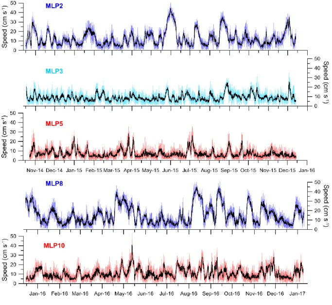
During the PAMELA-MOZ01 survey, three moorings (MLP2, MLP3 and MLP5; Fig. 2) were deployed in 164
November 2014 in the Zambezi and Tsiribihina Valleys and were recovered in December 2015 during 165
the PAMELA-MOZ04 survey. At the same time, two more moorings (MLP8 and MLP10; Fig. 2) were 166
deployed in the Zambezi Valley and recovered in January 2017 during the PAMELA-MOZ08 survey 167
(R/V Antea; Khripounoff, 2017). The moorings were located at water depths that range between 168
3415 and 4054 m (Fig. 2). They were thus under the influence of the upper part of the AABW and of 169
the mixing zone with the NADW (Figs. 1C, D). With the exception of mooring MLP5, they all consisted 170
of a sediment trap located at 40 m above the seafloor, a HOBO temperature sensor and a downward 171
looking 307 kHz ADCP located 30 m above the seafloor. MLP5 consisted of a 614 kHz ADCP mounted 172
22 m above the seafloor. 173
The Regional Ocean Modelling System (ROMS, here the version CROCO: https://www.croco-174
ocean.org/) was used to simulate the bottom circulation at a regional scale with a resolution of 1/36º 175
(~3 km). The simulations extended from 1993 to 2014. ROMS is a primitive equation model that can 176
realistically resolve basin-scale, regional and coastal oceanic processes at high resolution 177
(Shchepetkin and McWilliams, 2005). High resolution is here attained by three levels of nested grids, 178
communicating between each other (Debreu et al., 2012). ROMS has a free surface and uses a σ 179
topography following vertical grid. The model successfully resolves mesoscale eddies in the 180
Mozambique Channel (Halo et al., 2014). The bathymetry used in the model is GEBCO 2014 181
(Weatherall et al., 2015) smoothed for numerical constraints. 182
8 We used maps of Sea Level Anomalies (SLA) in order to link the observed changes in current velocity 183
with mesoscale features in the Mozambique Channel. The Ssalto/Duacs SLA heights (MSLA-H) were 184
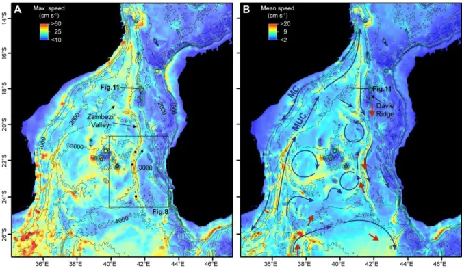
produced and distributed by the Copernicus Marine and Environment Monitoring Service (CMEMS) 185 (http://www.marine.copernicus.eu). 186 187 4. Results 188
4.1. Bottom currents in the Mozambique Channel 189
4.1.1. In situ current observations in the Zambezi and Tsiribihina Valleys 190
Five moorings were deployed in the Zambezi system during two years: (i) from October 2014 to 191
December 2015 in the Zambezi Valley 80 km upstream and 210 km downstream of the confluence 192
with the Tsiribihina Valley (MLP2 and MLP5, respectively), and in the Tsiribihina valley 95 km 193
upstream of the confluence (MLP3); (ii) from December 2015 to January 2017 close to the valley 194
confluence (MLP8) and 210 km downstream of the confluence (MLP10) (Figs. 2 and 3). Currents near 195
the seafloor show different directions depending on their location, but they often follow a direction 196
similar to the valley axis (Fig. 4). South of the confluence, moorings MLP5 and MLP10 mainly 197
recorded northward currents (Fig. 4). The other three sites, by contrast, show mainly southward 198
currents, with large inversions towards the N-NE, which are particularly remarkable at sites MLP2 199
and MLP8 (Fig. 4). The periods of S-SSW direction correspond to periods of higher current speed (Fig. 200
4). Rose diagrams of sites MLP5 and MLP10 show a wider range of current direction than sites MLP3, 201
MLP2 and MLP8 (Fig. 4). Currents at sites MLP5 and MLP10 are less constrained by the valley 202
morphology. In this area, the Zambezi U-shaped thalweg is lower, resulting in a less confined valley 203
and hence a lower impact on the bottom circulation (Fig. 3). 204
Current speed near the seafloor is very intense at all the studied sites (Fig. 5), reaching up to 53 cm s
-205
1. Upstream and close to the confluence, sites MLP2 and MLP8 registered mean speeds of the
206
available data set of 13 and 15 cm s-1, and maximum speeds of 51 cm s-1; while at site MLP3 in the
207
Tsiribihina Valley a mean speed of 9 cm s-1 and a maximum speed of 38 cm s-1 were registered.
9 Downstream of the confluence, moorings MLP5 and MLP10 registered mean speeds of 7 and 11 cm s
-209
1, and maximum speeds of 37 and 53 cm s-1, respectively (Fig. 5). The currents show periods of
210
intensified circulation, especially at sites MLP2 and MLP8, that can last up to one month (Fig. 5). 211
These periods of intense bottom currents are coincident with a change in current direction and an 212
increase in temperature (Fig. 6). The high frequency variability observed in the current data (Figs. 5 213
and 6) is related to tides. At site MLP8, the current direction is generally NNE when the currents are 214
weaker, while during the periods of intense circulation the direction reverses to SSW (Figs. 5 and 6). 215
These events of intense circulation are not related to turbidity currents because there is no 216
correlation between the current speed and the sediment flux obtained from a sediment trap (Fig. 6). 217
The measured sediment flux is usually low during the periods of strong currents, for instance during 218
December 2015-January 2016, April-May 2016 or August 2016. Miramontes et al. (accepted) also 219
observed reduced sedimentation from turbidity measurements during periods of intense currents on 220
the Hall seamount located in the centre of the Mozambique Channel (Fig. 1B). 221
222
4.1.2. Simulated bottom currents 223
The circulation near the seafloor obtained from the ROMS hydrodynamic model successfully 224
simulates the main currents that are known in the Mozambique Channel: surface currents flowing 225
southwards along the African continental margin at the surface and intermediate depths 226
(Mozambique Current), and deep currents flowing northwards along the same margin (Mozambique 227
Undercurrent) and back southwards along the western Madagascar margin (Fig. 7). The group of 228
seamounts and islands present in the centre of the Mozambique Channel generate multiple 229
topographic changes that result in a complex bottom circulation, forming gyres within small basins 230
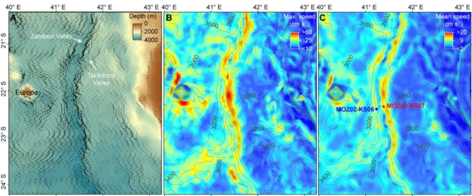
and around topographic highs (Fig. 7). 231
Hydrodynamic modelling results show strong currents flowing southwards along the western part of 232
the Davie Ridge with mean speeds of 10-15 cm s-1 and maximum speeds of 30-55 cm s-1 (Fig. 7). The
233
model also simulates intense currents along the Zambezi Valley, especially along the eastern flank, 234
10 with maximum velocities of 40-60 cm s-1, and mean velocities of 8-18 cm s-1 (Fig. 8), in agreement
235
with the in situ measurements (Fig. 5). On the basin seafloor outside the valleys, simulated bottom 236
currents are more intense to the west of the Zambezi Valley than to the east (towards the 237
Madagascar margin). West of the Zambezi Valley mean velocities oscillate between 5 and 14 cm s-1
238
and maximum velocities between 15 and 50 cm s-1, while east of the Zambezi Valley, mean velocities
239
are often around 3-5 cm s-1 (reaching locally 13 cm s-1) and maximum velocities of about 15 cm s-1
240
(reaching locally 40 cm s-1) (Fig. 8). Modelling results also show intense bottom circulation around
241
Europa Island, especially on the western and southern sides of the island, with mean velocities that 242
can reach up to 18 cm s-1 and maximum velocities up to 70 cm s-1 (Fig. 8).
243
In order to better understand the observed changes in current direction and intensity at mooring 244
sites, we calculated a composite of the Sea Level Anomaly (SLA), the bottom currents and the 245
barotropic currents from the ROMS model for the periods of time during which currents at the 246
mooring site MLP2 were above 25 cm s-1 (Fig. 9). The results show that during the periods of intense
247
southward flow along the Zambezi Valley, the Mozambique Undercurrent is less intense, and there is 248
an intensification of bottom currents flowing eastwards north and south of the group of islands and 249
seamounts, and southwards along the Zambezi Valley (Fig. 9B). The composite of the SLA shows the 250
presence of a large anticyclonic eddy (positive SLA) located between 21-24°S and 36-41°E. The 251
composite of barotropic currents (i.e. average of the currents in the whole water column) follows the 252
eddy field, thus demonstrating that eddies are affecting the whole water column (Fig. 9C). The 253
bottom current direction and zone of high intensity are generally coincident with the barotropic 254
currents. However, the model results show a focusing of bottom currents along topographic reliefs 255
such as the islands and seamounts, and the Zambezi Valley (Fig. 9). 256
257
4.2. Evidence of contouritic sedimentation in the Zambezi turbidite system 258
The Zambezi turbidite system is mainly composed of two valleys: the Zambezi Valley (U-shaped 259
thalweg and V-shaped valley; Fierens et al., accepted) originating from the Mozambican continental 260
11 slope, and the Tsiribihina Valley originating from the western Madagascar slope (Figs. 1 and 2). Both 261
valleys converge at about 22°S, and the combined valley extends with a N-S orientation until about 262
26°S, where the depositional fan system starts to develop. Levees are absent along the main axis of 263
the recent valleys and the flanks are often eroded (Fig. 3). The Zambezi Valley flanks are asymmetric, 264
with more sediment accumulation east of the valley. The Tsiribihina Valley is more sinuous and 265
narrower than the Zambezi Valley (Figs. 2 and 3). The flanks of the Zambezi Valley are covered by 266
bedforms (Fig. 3). Sediment architectures similar to the Zambezi Valley flanks are observed in a 267
purely contourite depositional system associated with a seamount near the Madagascar Ridge (Fig. 268
10). Elongated separated mounded drifts covered with large bedforms are separated from the 269
seamounts by moats characterised by a flat homogeneous bottom (Fig. 10). The Serpa Pinto Valley 270
used to act as the main conduit for terrigenous sediments in the Mozambique Channel until the Early 271
Miocene (Droz and Mougenot, 1987). Despite being inactive, its relief can still be recognised on the 272
present seafloor, and its sedimentary geometry shows similarities with the Zambezi Valley (Fig. 11). 273
West of this valley the seafloor is dominated by an erosional surface and by large bedforms (Fig. 11). 274
Further evidence of bottom-current related features was obtained from two sediment piston cores 275
(MOZ02-KS06 and MOZ02-KS07) collected on the Zambezi Valley flanks about 60 km south of the 276
confluence with the Tsiribihina Valley (Fig. 12), in areas with strong bottom currents according to the 277
hydrodynamic modelling results (Fig. 8). The upper 0.80 KS07) and 1.75 metres (MOZ02-278
KS06) of the sediment records are composed of foraminiferal sand (planktonic and benthic 279
foraminifers), without clear lamination (Fig. 13). This area adjacent to the valley is characterised by 280
high backscatter (Fig. 12C), in agreement with the sand sampled in cores (Fig. 13). The first 281
centimetres of core KS06 have been dated at 25,350 ± 240 cal yr BP, and of core MOZ02-282
KS07 at 11,648 ± 284 cal yr BP. According to the analysis of nannofossil assemblages of core MOZ02-283
KS06, the foraminiferal sand began to be deposited 600-830 kyr ago (zone NN19-CN14a, absence of 284
R. asanoi, at 1.69-1.70 m) (Fig. 13A). This allows the sedimentation rate to be estimated at about 0.2-285
0.3 cm kyr-1. Low sedimentation rates have also been observed in hemipelagic sediment in the
12 vicinity of the Zambezi turbidite system. Sedimentation rates obtained by Fierens et al. (2017) at 287
seven different sites for the last 248-718 kyr range between 0.5 and 2.4 cm kyr-1 (Fig. 1B). The
mud-288
sand transition in core MOZ02-KS06 is characterised by a hiatus. The age of the top of the mud unit 289
(1.80-1.81 m) was estimated at 2.5-5 Ma (zones NN16-NN14). The foraminiferal sand layers display 290
coarsening-up sequences, which are more marked in core MOZ02-KS06. The volume of sand in these 291
layers ranges between 54 and 89% in core KS06 and between 45 and 70% in core MOZ02-292
KS07 (Fig. 12). The increasing amount of carbonate sand in these layers is consistent with an increase 293
in the XRF Ca/Fe ratio (due to a higher concentration of foraminifers) and in the XRF ln(Zr/Rb) ratio 294
(due to the more energetic conditions and coarser grain size). Heavy minerals such as zircon can be 295
accumulated due to winnowing under intense bottom currents (Bahr et al., 2014). The upper part of 296
the muddy sequence in core MOZ02-KS07 is characterised by burrows infilled with foraminifera sand 297
from the upper sandy layer (Fig. 13B). This observation suggests that the sand could be contouritic. 298
Contourites exhibit continuous and homogeneous bioturbation, while turbidites are mainly 299
bioturbated from the top (Rodríguez-Tovar and Hernández-Molina, 2018). This interpretation is also 300
supported by the observed inverse grading sequence (Fig. 13), which is typical of contourites 301
(Rebesco et al., 2014, and references therein). 302
303
5. Discussion 304
5.1. Modelled, observed and inferred circulation near the seafloor of the Mozambique Channel 305
The ROMS hydrodynamic model successfully simulated bottom circulation in the Mozambique 306
Channel in terms of speed and direction. The modelling results are in agreement with in situ 307
measurements and directions inferred from morpho-sedimentary features recorded in previous 308
studies. 309
The Agulhas Undercurrent (AUC) carries AAIW and NADW northwards below 700 m water depth 310
along the southeast African continental slope, with speeds between 30 and 40 cm s-1 (Donohue et al.,
311
2000). The Mozambique Undercurrent (MUC) is the continuation of the AUC (Fig. 1A; Beal and 312
13 Bryden, 1997). Ullgren et al. (2012) measured the MUC flowing northwards at 1500-2500 m water 313
depth in a section at 37°S, with mean speed below 4 cm s-1 and maximum values of 35 cm s-1. De
314
Ruijter et al. (2002) reported that the MUC attains speeds ranging from 10 to 20 cm s-1. In the area
315
studied by Ullgren et al. (2012) (~ 17°S) our model results show mean bottom currents of about 10 316
cm s-1 and maximum speeds of 33-40 cm s-1 (Fig. 7), which is in agreement with in situ
317
measurements. The modelling results show a southwards flow west of the Davie Ridge (Fig. 7) that 318
has also been observed in the in situ measurements published by Ullgren et al. (2012). 319
Morpho-sedimentary features related to bottom currents also support the modelling results in the 320
central and southern part of the Mozambique Channel in the depth range of the NADW (2000-3500 321
m water depth) and the AABW (below 3500 m) (Fig. 1). An erosional surface and large bedforms 322
were observed in the area of strong currents flowing southwards near the Davie Ridge (Figs. 7 and 323
11). This southward setting bottom current continues along the Zambezi Valley (Fig. 7), inducing the 324
erosion of the V-shaped valley flank described by Fierens et al. (accepted) (Figs. 3 and 12) and the 325
deposition of contouritic sand (Fig. 13). Kolla et al. (1980) inferred current directions towards the 326
south in the northern part of the Zambezi Valley and towards the north in the southern part of the 327
valley, as observed in the in situ measurements described in the present study (Fig. 4). Kolla et al. 328
(1980), Breitzke et al. (2017) and Wiles et al. (2017b) showed that bedforms are more abundant on 329
the basin floor west of the Zambezi Valley than east of the valley. This asymmetric distribution of the 330
bedforms is in agreement with the modelling results, which show stronger bottom currents on the 331
basin floor west of the Zambezi Valley (Figs. 7 and 8). Moreover, the strong currents NW of Europa 332
Island (Fig. 8) may explain the observed asymmetry of a carbonate levee system originating from the 333
island, as documented by Counts et al. (2018). 334
The central part of the Mozambique Channel is characterised by the presence of multiple 335
topographic highs and small basins (Fig. 1B). This bathymetric heterogeneity induces local changes in 336
the bottom circulation, with the formation of gyres within the basins (e.g. in the basin southwest of 337
the main group of seamounts and islands) and currents flowing around the topographic highs (e.g. 338
14 northeast of the group of islands and seamounts) (Fig. 7). This bottom circulation pattern could be 339
the cause of the arcuate and sub-circular bedforms observed by Breitzke et al. (2017) in this area. 340
In the southernmost part of the Mozambique Channel, the AABW flows northwards east of the 341
Mozambique Ridge. It is then constrained to the north by the decreasing water depth, being forced 342
to return southwards along the Madagascar Ridge (Figs. 1 and 7). The modelled current direction is 343
once again in agreement with the inferred directions from morpho-sedimentary features and bottom 344
photography described by Kolla et al. (1980) and Breitzke et al. (2017). 345
346
5.2. Origin of intense bottom currents in the Zambezi Valley 347
Anticyclonic rings in the Mozambique Channel have a large barotropic component, affecting the 348
whole water column and reaching the bottom of the channel, as identified by velocity measurements 349
and water properties (de Ruijter et al., 2002; Swart et al., 2010). Halo et al. (2014) showed that these 350
large anticyclonic structures mainly propagate along the western edge of the Mozambique Channel. 351
Hence, they would not directly affect the deep part of the Zambezi Valley. However, the presence of 352
eddies may induce changes in the deep circulation pattern. Ullgren et al. (2012) correlated 353
hydrographic properties at intermediate and greater depths with changes in current direction. 354
Anticyclonic eddies passing through the narrowest part of the Mozambique Channel carry salty and 355
warm RSW southwards, and thereby reduce or even revert the northward transport related to the 356
Mozambique Undercurrent (Ullgren et al., 2012). They recognised that the meridional or vertical 357
displacement of the water-mass interfaces induces rapid changes in temperature and salinity at fixed 358
stations and that the end of the hydrographic changes (temperature and salinity) related to the 359
velocity of the Mozambique Undercurrent is more abrupt than its onset. Similar variations have been 360
observed in the mooring sites of the Zambezi Valley. The periods of intense currents are correlated 361
with a change in current direction (southwards) and an increase in temperature (Fig. 6). The end of 362
the warm water intrusion period is more abrupt than its onset. In some cases, such as in May 2016, 363
the end of the event lasts only a few hours (Fig. 6). Modelling results show that during periods of 364
15 intense southward currents at mooring site MLP2, a large anticyclonic ring is present at 21-24 °S 365
between the African continental slope and the group of islands and seamounts in the centre of the 366
Mozambique Channel (Fig. 9). Anticyclones can block the northward transport of the Mozambique 367
Undercurrent along the Mozambican slope (Fig. 9; Ullgren et al., 2012). When the northward 368
transport along the western part of the Mozambique Channel is limited, the southward NADW 369
transport may increase along the Zambezi Valley (Fig. 9). This may induce a deepening of the 370
interface between the NADW and the AABW at the Zambezi Valley (Fig. 14). The NADW-AABW 371
interface would thus move southwards, and the mooring sites would detect an increase in 372
temperature related to the warmer NADW compared to the AABW (Figs. 6 and 14). Intense 373
southward setting currents are related to these changes in the water-mass properties (Fig. 7). 374
Although the mooring duration is too short for a precise assessment, the occurrence of 7 events in a 375
year is consistent with the eddy variability obtained from satellite altimetry by Schouten et al. (2003) 376
and from the LOCO mooring by Harlander et al. (2009) and Ridderinkhof et al. (2010). This is also 377
consistent with the frequency of occurrence of Mozambique Channel Rings obtained by Halo et al. 378
(2014) from altimetry and two ocean models. 379
The effect of eddies on the seafloor may be direct: as in the Gulf of Cadiz, by generating sub-circular 380
depressions (García et al., 2016), and in the NW Atlantic Ocean, by generating benthic nepheloid 381
layers (Gardner et al., 2017); or indirect, as shown in the present study. Eddies can influence the 382
deep circulation and induce periods of strong bottom currents that may erode the seafloor, winnow 383
fine-grained sediment or generate furrows and large bedforms. Gardner et al. (2017) observed 384
benthic storms (i.e. events of strong currents capable of eroding the seafloor and generating benthic 385
nepheloid layers) in areas with high sea-surface eddy kinetic energy, related to the Gulf Stream or its 386
associated rings. The importance of eddies in controlling deep-sea sedimentation is also supported 387
by a global comparison of contourite distribution and hydrodynamic modelling, which showed that 388
contourites are located in areas with high simulated bottom eddy kinetic energy (Thran et al., 2018). 389
16 Shanmugam (2016) criticizes the use of the generic term contourite because of its broad sense that 390
covers all the sediment affected by any bottom current, and suggests the use of a classification 391
according to the different processes that generate the deposits: contourite for geostrophic currents, 392
bottom-current reworked sands for wind-driven bottom currents, tidalite for tide-driven bottom 393
currents, and baroclinite for internal waves or tide-driven baroclinic currents. But in the ocean, 394
different processes are superimposed with different daily, seasonal and interannual frequencies. For 395
instance, geostrophic currents in the Zambezi Valley are modulated in the frequency band of tides 396
and anticyclones. It is very hard or almost impossible to relate a pure oceanographic process to a 397
pure depositional facies. Therefore, we consider that the generic term contourite is appropriate for 398
any sediment affected by bottom currents, although in contrast to the common definition of Rebesco 399
et al. (2014) and references therein, bottom currents do not need to be persistent, their velocity may 400
strongly vary, as shown in this study. 401
402
5.3. Implications for source-to-sink studies 403
Mixed contourite-turbidite systems are often characterised by an alternation of contouritic and 404
turbiditic deposits, that result from variations in the dominant sedimentary process (Mulder et al., 405
2008). The Zambezi system is a particular mixed system dominated by erosive processes related to 406
the oceanic circulation. The Zambezi Valley flanks are eroded (V-shaped), and levees are absent in 407
most part of the system. Another particularity of the Zambezi mixed system is the absence of 408
contourite drift-turbidite alternation, as observed in mixed systems of the southeastern Brazilian 409
margin (Viana et al., 1999) or of the South China Sea (Zhu et al., 2010; He et al., 2013). In addition, no 410
typical sediment drifts have been identified associated with the turbidite system, as described for 411
example in Antarctica (Rebesco et al., 2002). At present, the circulation in the Mozambique Channel 412
is probably too intense to allow the formation of large sediment drifts. The seafloor is characterised 413
by erosive features such as furrows and irregular large-scale bedforms, especially west of the 414
Zambezi Valley (Breitzke et al., 2017). Lower sediment accumulations west of the Zambezi Valley may 415
17 also be related to stronger bottom currents that could prevent or reduce sediment deposition in this 416
area, compared to the area east of the valley where weaker bottom currents would favour sediment 417
accumulation (Figs. 3 and 8). Most of the sediments carried by turbidity currents are probably re-418
transported by bottom currents at all depths, thus little fine-grained sediments would arrive as a 419
gravity flow to the deep part of the basin. 420
Van Sebille et al. (2015) demonstrated that planktonic foraminifera shells could be transported off 421
South Africa hundreds of kilometres before being deposited on the seafloor. They considered for the 422
foraminifera shells a settling velocity of 0.23 cm s-1, that is much higher than the settling velocity of
423
coarse silt (0.1 cm s-1) or fine silt (0.01 cm s-1) (Gibbs et al., 1971). Therefore, the fine-grained
424
sediments could be transported in suspension by the eddies travelling southwards and be finally 425
deposited outside the Mozambique Channel. Zhang et al. (2014) showed that surface-generated 426
mesoscale eddies of the South China Sea can trap and transport sediment in suspension, influencing 427
deep-water sedimentary processes. 428
The Zambezi Valley presents a low sinuosity (Wiles et al., 2017b), in contrast to most of the low-429
latitude submarine channels that are characterised by high sinuosity due to a regular and stable 430
sediment supply, usually composed of fine-grained material (Mulder, 2011; Peakall et al., 2012). This 431
particularity of the Zambezi Valley may be caused by sediment sorting due to bottom currents before 432
the formation of the turbidity current or during its movement. The NAMOC (Northwest Atlantic Mid-433
Ocean Channel) in the Labrador Sea and the Tanzania channel in the Southwest Indian Ocean show 434
similar characteristics to the Zambezi Valley: absence of well-developed aggradational levees, low 435
sinuosity and flat erosive thalwegs (Hesse et al., 1987; Klaucke et al., 1998; Bourget et al., 2008; 436
Wiles et al., 2017b). All these areas are under the influence of strong western boundary currents. For 437
instance, the Eirik and Gloria Drifts are located in close vicinity to the NAMOC turbidite system 438
(Klaucke et al., 1998), evidencing the effect of bottom currents in the area. The slope of North 439
Mozambique-Tanzania is also well known for the interaction of contouritic and turbiditic processes. 440
Palermo et al. (2014) interpreted the presence of channel and lobe complexes flanked by unilateral 441
18 drift mounds in the Lower Eocene depositional sequence of the Rovuma Basin as the effect of 442
bottom currents that would deviate the fine-grained suspension cloud of the turbidity currents. This 443
process would remove part of the fine-grained sediments from the turbidity current, increasing the 444
grain size composition of the turbidity current, and thus generating low sinuosity channels even at 445 low latitudes. 446 447 6. Conclusion 448
In situ current measurements, obtained from 5 mooring stations in the Zambezi and Tsiribihina 449
Valleys, and regional hydrodynamic modelling show that the circulation near the seafloor in the 450
Mozambique Channel is very intense and may have an important impact on deep-sea sedimentation. 451
The main conclusions of this study are: 452
(1) Measured mean bottom currents in the Zambezi and Tsiribihina Valleys at 3400-4050 m water 453
depth are about 9-15 cm s-1, but bottom currents show a high variability, with periods of intense
454
circulation characterised by current speeds up to 53 cm s-1. The results of the ROMS hydrodynamic
455
model show that bottom currents are accelerated along the V-shaped valley flanks, with velocities 456
similar to the mooring data, and in agreement with the flank erosion observed in seismic profiles. 457
The periods of intense current speed are correlated with a reversal of the current direction and with 458
an increase in temperature. These events seem to be related to the eddy activity, since they present 459
a similar frequency as the anticyclonic eddies (about 7 per year). Moreover, modelling results show 460
that during the identified periods of intense bottom currents, an anticyclonic ring was present 461
between the Mozambican slope and the centre of the Mozambique Channel. The anticyclone may 462
induce a reduction of the northward transport of the Mozambique Undercurrent along the 463
Mozambican margin. Therefore, the southward transport of North Atlantic Deep Water along the 464
eastern part of the Mozambique Channel could be enhanced, deepening the interface between the 465
North Atlantic Deep Water and the Antarctic Bottom Water, and generating increased bottom 466
currents and temperature at the mooring sites. 467
19 (2) Multibeam bathymetry and seismic reflection data show that the Zambezi turbidite system is 468
mainly dominated by erosive processes: the Zambezi Valley flanks are eroded and covered in some 469
areas by contouritic sand. Moreover, levees are absent in most of the system, and large zones with 470
furrows and large bedforms are found in the vicinity of the turbidite system. The morphological 471
characteristics of the Zambezi Valley (low sinuosity, absence of levees and a flat erosive U-shaped 472
thalweg) are not typical of low latitude systems, which are usually mud-rich systems. The strong 473
bottom currents present in the Mozambique Channel may transport away most of the fine-grained 474
sediment carried in suspension by the turbidity currents, generating coarser and probably better 475
sorted turbidity currents. 476
477
Acknowledgments 478
We thank the Captains, crews and onboard scientific teams of the PTOLEMEE, PAMELA-MOZ01 and 479
PAMELA-MOZ02 surveys onboard the R/V L’Atalante, as well as the PAMELA-MOZ04 survey onboard 480
the R/V Pourquoi pas? and the PAMELA-MOZ08 survey onboard the R/V Antea. The oceanographic 481
surveys PTOLEMEE, PAMELA-MOZ01, PAMELA-MOZ02, PAMELA-MOZ04 and PAMELA-MOZ08, as 482
well as Elda Miramontes’ Post-Doctoral fellowship and Ruth Fierens’ PhD are co-funded by TOTAL 483
and IFREMER as part of the PAMELA (PAssive Margin Exploration Laboratories) scientific project. The 484
PAMELA project is a scientific project led by Ifremer and TOTAL in collaboration with Université de 485
Bretagne Occidentale, Université Rennes 1, Université Pierre and Marie Curie, CNRS and IFPEN. We 486
also thank Venkatarathnam Kolla, three anonymous reviewers and the Editor-in-Chief Michele 487
Rebesco for their constructive comments, which significantly improved the manuscript. 488
489
References 490
Bahr, A., Jiménez‐Espejo, F.J., Kolasinac, N., Grunert, P., Hernández‐Molina, F.J., Röhl, U., Voelker, 491
A.H.L., Escutia, C., Stow, D.A.V., Hodell, D., Alvarez‐Zarikian, C.A., 2014. Deciphering bottom 492
current velocity and paleoclimate signals from contourite deposits in the Gulf of Cádiz during the 493
20 last 140 kyr: An inorganic geochemical approach. Geochemistry, Geophysics, Geosystems 15(8), 494
3145-3160. 495
Beal, L.M., and H.L. Bryden, 1997. Observations of an Agulhas undercurrent, Deep Sea Research, 44, 496
1715– 1724. 497
Bourget, J., Zaragosi, S., Garlan, T., Gabelotaud, I., Guyomard, P., Dennielou, B., Ellouz-Zimmermann, 498
N., Schneider, J.L., the FanIndien 2006 survey crew, 2008. Discovery of a giant deep-sea valley in 499
the Indian Ocean, off eastern Africa: The Tanzania channel. Marine Geology 255(3), 179-185. 500
Breitzke, M., Wiles, E., Krocker, R., Watkeys, M.K., Jokat, W., 2017. Seafloor morphology in the 501
Mozambique Channel: evidence for long-term persistent bottom-current flow and deep-reaching 502
eddy activity. Marine Geophysical Research 38(3), 241-269. 503
Calvès, G., Toucanne, S., Jouet, G., Charrier, S., Thereau, E., Etoubleau, J., Marsset, T., Droz, L., Bez, 504
M., Abreu, V., Jorry, S., Mulder, T., Lericolais, G., 2013. Inferring denudation variations from the 505
sediment record; an example of the last glacial cycle record of the Golo Basin and watershed, East 506
Corsica, western Mediterranean sea. Basin Research, 25(2), 197-218. 507
Castelino, J.A., Reichert, C., Jokat, W., 2017. Response of Cenozoic turbidite system to tectonic 508
activity and sea-level change off the Zambezi Delta. Mar Geophys Res. doi:10.1007/s11001-017-509
9305-8. 510
Counts, J. W., Jorry, S. J., Leroux, E., Miramontes, E., Jouet, G., 2018. Sedimentation adjacent to 523 511
atolls and volcano-cored carbonate platforms in the Mozambique Channel (SW Indian Ocean). 524 512
Marine Geology 404, 41–59. 513
Courgeon, S., Jorry, S.J., Camoin, G.F., BouDagher-Fadel, M.K., Jouet, G., Révillon, S., Bachèlery, P., 514
Pelleter, E., Borgomano, J., Poli, E., Droxler, A.W., 2016. Growth and demise of Cenozoic isolated 515
carbonate platforms: New insights from the Mozambique Channel seamounts (SW Indian Ocean). 516
Marine Geology 380, 90-105. 517
21 Covault, J.A., Romans, B.W., Graham, S.A., Fildani, A., Hilley, G.E., 2011. Terrestrial source to deep-518
sea sink sediment budgets at high and low sea levels: insights from tectonically active southern 519
California. Geology 39, 619–622. 520
de Ruijter, W.P.M., Ridderinkhof, H., Lutjeharms, J.R.E., Schouten, M.W., Veth, C., 2002. Observations 521
of the flow in the Mozambique Channel. Geophysical Research Letters 29(10), 522
http://dx.doi.org/10.1029/2001GL013714. 523
Debreu, L., Marchesiello, P., Penven, P., Cambon, G., 2012. Two-way nesting in split-explicit ocean 524
models: algorithms, implementation and validation, Ocean Model. 49-50, 1-21. 525
DiMarco, S.F., Chapman, P., Nowlin, W.D. Jr, Hacker, P., Donohue, K., Luther, M., Johnson and G.C., 526
Toole, J., 2002. Volume transport and property distributions of the Mozambique Channel. Deep-527
Sea Res II (Topical Studies in Oceanography), 49, 1481–1511. 528
Donohue, K.A., Firing, E., Beal, L., 2000. Comparison of three velocity sections of the Agulhas Current 529
and Agulhas Undercurrent. Journal of Geophysical Research: Oceans, 105(C12), 28585-28593. 530
Droz, L., Mougenot, D., 1987. Mozambique Upper Fan: Origin of depositional units. AAPG Bulletin 71, 531
1355–1365. 532
Fierens, R., Droz, L., Toucanne, S., Jorry, S., Raisson, F., 2017. Plio-Quaternary sedimentation in the 533
Mozambique Channel and in the Zambezi Fan. In EGU General Assembly Conference Abstracts, 534
19, 7520. 535
Fierens, R., Droz, L., Toucanne, S., Raisson, F., Jouet, G., Babonneau, N., Landurain, S., Jorry, S.J., 536
accepted. Subsurface geomorphology of the Zambezi turbidite system from new bathymetric and 537
sub-bottom profiler data. Geomorphology. 538
Flemming, B.W. and Kudrass, H., 2018. Large dunes on the outer shelf off the Zambezi Delta, 539
Mozambique: evidence for the existence of a Mozambique Current. Geo-Marine Letters, 38, 95– 540
105. 541
22 García, M., Hernández-Molina, F.J., Alonso, B., Vázquez, J.T., Ercilla, G., Llave, E., Casas, D., 2016. 542
Erosive sub-circular depressions on the Guadalquivir Bank (Gulf of Cadiz): Interaction between 543
bottom current, mass-wasting and tectonic processes. Marine Geology 378, 5-19. 544
Gardner, W.D., Tucholke, B.E., Richardson, M.J., Biscaye, P.E., 2017. Benthic storms, nepheloid layers, 545
and linkage with upper ocean dynamics in the western North Atlantic. Marine Geology 385, 304-546
327. 547
Gibbs, R.J., Matthews, M.D., Link, D.A., 1971. The relationship between sphere size and settling 548
velocity. Journal of sedimentary research 41(7), 7-18. 549
Giraudeau, J., Christensen, B.A., Hermelin, O., Lange, C.B., Motoyama, I., Shipboard Scientific Party, 550
1998. Biostratigraphic age models and sedimentation rates along the southwest African margin. 551
In: Proceedings of the Ocean Drilling Program Initial Reports, (Eds. G. Wefer, W.H. Berger, C. 552
Richter), 175, pp. 543-546. 553
Gordon, A.L., 1986. Inter-ocean exchange of thermocline water. Geophysical Research Letters 91, 554
5037–5046. 555
Halo, I., Backeberg, B., Penven, P., Ansorge, I., Reason, C., Ullgren, J.E., 2014. Eddy properties in the 556
Mozambique Channel: A comparison between observations and two numerical ocean circulation 557
models. Deep Sea Research Part II: Topical Studies in Oceanography 100, 38-53. 558
Harlander, U., Ridderinkhof, H., Schouten, M. W., De Ruijter, W. P. M., 2009. Long‐term observations 559
of transport, eddies, and Rossby waves in the Mozambique Channel. Journal of Geophysical 560
Research: Oceans 114(C2). 561
He, Y., Xie, X., Kneller, B. C., Wang, Z., Li, X., 2013. Architecture and controlling factors of canyon fills 562
on the shelf margin in the Qiongdongnan Basin, northern South China Sea. Marine and Petroleum 563
Geology 41, 264-276. 564
Helland-Hansen, W., Sømme, T.O., Martinsen, O.J., Lunt, I., Thurmond, J., 2016. Deciphering earth's 565
natural hourglasses: perspectives on source-to-sink analysis. Journal of Sedimentary Research 566
86(9), 1008-1033. 567
23 Hernández-Molina, F. J., Soto, M., Piola, A. R., Tomasini, J., Preu, B., Thompson, P., Badalini, G., 568
Creaser, A., Violante, R.A., Morales, E., Paterlini, M., De Santa Ana, H., 2016. A contourite 569
depositional system along the Uruguayan continental margin: Sedimentary, oceanographic and 570
paleoceanographic implications. Marine Geology 378, 333-349. 571
Hernández-Molina, F. J., Campbell, S., Badalini, G., Thompson, P., Walker, R., Soto, M., Conti, B., Preu, 572
B., Thieblemont, A., Hyslop, L., Miramontes, E., Morales, E., 2017. Large bedforms on contourite 573
terraces: Sedimentary and conceptual implications. Geology 46, 27-30. 574
Hesse, R., Chough, S.K., Rakofsky, A., 1987. The Northwest Atlantic Mid-Ocean Channel of the 575
Labrador Sea. V. sedimentology of a giant deep-sea channel. Canadian Journal of Earth 576
Sciences 24(8), 1595-1624. 577
Jorry, S., 2014. PTOLEMEE cruise, RV L’Atalante, http://dx.doi.org/10.17600/14000900. 578
Jorry, S. J., Camoin, G. F., Jouet, G., Le Roy, P., Vella, C., Courgeon, S., Prat, S., Fontanier, C., Paumard, 579
V., Boulle, J., Caline, B., Borgomano, J., 2016. Modern sediments and Pleistocene reefs from 580
isolated carbonate platforms (Iles Eparses, SW Indian Ocean): A preliminary study. Acta 581
oecologica, 72, 129–143. 582
Jouet, G., Deville, E., 2015. PAMELA-MOZ04 cruise, RV Pourquoi pas?, 583
http://dx.doi.org/10.17600/15000700. 584
Khripounoff, A., 2017. PAMELA-MOZ08 cruise, RV Antea, http://dx.doi.org/10.17600/17003900. 585
Klaucke, I., Hesse, R., Ryan, W.B.F., 1998. Seismic stratigraphy of the Northwest Atlantic Mid-Ocean 586
Channel: growth pattern of a mid-ocean channel-levee complex. Marine and Petroleum 587
Geology 15(6), 575-585. 588
Kolla, V., Eittreim, S., Sullivan, L., Kostecki, J.A., Burckle, L.H., 1980. Current-controlled, abyssal 589
microtopography and sedimentation in Mozambique Basin, Southwest Indian Ocean. Marine 590
Geology 34, 171–206. 591
Lutjeharms, J.R.E., 2006. The Agulhas Current, Vol. 1. Springer-Verlag, Berlin. 592
24 Mahanjane, E.S., 2014. The Davie Fracture Zone and adjacent basins in the offshore Mozambique 593
Margin–A new insights for the hydrocarbon potential. Marine and Petroleum Geology 57, 561-594
571. 595
Mantyla, A.W., and Reid, J.L., 1995. On the origins of deep and bottom waters of the Indian Ocean. 596
Journal of Geophysical Research: Oceans 100(C2), 2417-2439. 597
Miramontes, E., Jorry, S.J., Jouet, G., Counts, J.W., Courgeon, S., Le Roy, P., Guerin, C., Hernández-598
Molina, F.J., accepted. Deep marine dunes on drowned isolated carbonate terraces (Mozambique 599
Channel, SW Indian Ocean). Sedimentology, https://doi.org/10.1111/sed.12572. 600
Mulder, T., 2011. Gravity processes and deposits on continental slope, rise and abyssal plains. In: 601
Hüneke, H., Mulder, T. (Eds.), Deep-sea Sediments, Developments in Sedimentology, 63. Elsevier, 602
Amsterdam, pp. 25–148. 603
Mulder, T., Faugères, J.C., Gonthier, E., 2008. Mixed turbidite–contourite systems. In: Rebesco, M., 604
Camerlenghi, A. (Eds.), Contourites. Developments in Sedimentology, 60. Elsevier, Amsterdam, pp. 605
435-456. 606
Olu, K., 2014. PAMELA-MOZ01 cruise, RV L’Atalante, http://dx.doi.org/10.17600/14001000. 607
Palermo, D., Galbiati, M., Famiglietti, M., Marchesini, M., Mezzapesa, D., Fonnesu, F., 2014. Insights 608
into a New Super-Giant Gas Field - Sedimentology and Reservoir Modeling of the Coral Complex, 609
Offshore Northern Mozambique. Offshore Technology Conference Asia, Malaysia: OTC-24907-MS, 610
1-8. 611
Peakall, J., Kane, I.A., Masson, D.G., Keevil, G., McCaffrey, W.D., Corney, R., 2012. Global (latitudinal) 612
variation in submarine channel sinuosity. Geology 40, 11–14. 613
Pujos, A. (1988). Spatio-temporal distribution of some Quaternary coccoliths. Oceanologica Acta, 11, 614
65-77. 615
Quartly, G.D., de Cuevas, B.A. and Coward, A.C., 2013. Mozambique Channel eddies in GCMs: a 616
question of resolution and slippage. Ocean Modelling, 63, 56–67. 617
25 Reale, V., and Monechi, S., 2005. Distribution of the calcareous nannofossil Reticulofenestra asanoi 618
within the Early-Middle Pleistocene transition in the Mediterranean Sea and Atlantic Ocean: 619
correlation with magneto-and oxygen isotope stratigraphy. Geological Society, London, Special 620
Publications, 247, 117-130. 621
Rebesco, M., Pudsey, C., Canals, M., Camerlenghi, A., Barker, P., Estrada, F., Giorgetti, A., 2002. 622
Sediment drift and deep-sea channel systems, Antarctic Peninsula Pacific Margin. In: Stow, D.A.V., 623
Pudsey, C.J., Howe, J.A., Faugères, J.C., Viana, A.R. (Eds.), Deepwater Contourite Systems: Modern 624
Drifts and Ancient Series, Seismic and Sedimentary Characteristics. Geological Society, London, 625
Memoirs, 22, pp. 353–371. 626
Rebesco, M., Hernández-Molina, F.J., Van Rooij, D.,Wåhlin, A., 2014. Contourites and associated 627
sediments controlled by deep-water circulation processes: State-of-the-art and future 628
considerations. Marine Geology 352, 111-154. 629
Reimer, P.J., Bard, E., Bayliss, A., Beck, J.W., Blackwell, P.G., Ramsey, C.B., Buck, C.E., Cheng, H., 630
Edwards, R.L., Friedrich, M., Grootes, P.M., Guilderson, T.P., Haflidason, H., Hajdas, I., Hatte, C., 631
Heaton, T.J., Hoffmann, D.L., Hogg, A.G., Hughen, K.A., Kaiser, K.F., Kromer, B., Manning, S.W., 632
Niu, M., Reimer, R.W., Richards, D.A., Scott, E.M., Southon, J.R., Staff, R.A., Turney, C.S.M., van der 633
Plicht, J., 2013. IntCal13 and Marine13 radiocarbon age calibration curves 0–50,000 years cal BP. 634
Radiocarbon 55, 1869–1887. 635
Ridderinkhof, H., van der Werf, P.M., Ullgren, J.E., van Aken, H.M., van Leeuwen, P.J., de Ruijter, 636
W.P.M., 2010. Seasonal and interannual variability in the Mozambique Channel from moored 637
current observations. Journal of Geophysical Research: Oceans 115(C6), 638
http://dx.doi.org/10.1029/2009JC005619. 639
Robin, C., Droz, L., 2014. PAMELA-MOZ02 cruise, RV L’Atalante, 640
http://dx.doi.org/10.17600/14001100. 641
Rodríguez-Tovar, F.J., Hernández-Molina, F.J., 2018. Ichnological analysis of contourites: Past, present 642
and future. Earth-science reviews, 28-41. 643
26 Romans, B.W., Castelltort, S., Covault, J.A., Fildani, A., Walsh, J.P., 2016. Environmental signal 644
propagation in sedimentary systems across timescales. Earth-Science Reviews 153, 7-29. 645
Sato, T., Kameo, K. and Takayama, T. (1991). Coccolith biostratigraphy of the Arabian Sea. In: 646
Proceedings of the Ocean Drilling Program. Scientific Results, Oman Margin/Neogene Package: 647
Covering Leg 117 of the Cruises of the Drilling Vessel JOIDES Resolution, Port Louis, Mauritius, to 648
Port Louis, Mauritius, Sites 720-731, 19 August 1987-17 October 1987 (Eds. Prell, W.L., Niitsuma, 649
N., et al.), 117, 37-54. 650
Schott, F. A., S.-P. Xie, J. P. McCreary, Jr., 2009. Indian Ocean circulation and climate variability. 651
Reviews of Geophysics 47, RG1002. 652
Schouten, M.W., de Ruijter, W.P., Van Leeuwen, P.J., Ridderinkhof, H., 2003. Eddies and variability in 653
the Mozambique Channel. Deep Sea Research Part II: Topical Studies in Oceanography 50(12-13), 654
1987-2003. 655
Schulz, H., Lückge, A., Emeis, K., Mackensen, A., 2011. Variability of Holocene to Late Pleistocene 656
Zambezi riverine sedimentation at the upper continental slope off Mozambique, 15°–21°S. Marine 657
Geology 286, 21–34. 658
Shanmugam, G., 2016 The Contourite Problem. In: Mazumder, R. (Ed.). Sediment Provenance. 659
Elsevier, 2016, pp. 193–253. 660
Shchepetkin, A.F., and McWilliams, J.C., 2005. The regional oceanic modeling system (ROMS): a split-661
explicit, free-surface, topography-following-coordinate oceanic model. Ocean Model 9, 347–404. 662
Sømme, T.O., Helland‐Hansen, W., Martinsen, O.J., Thurmond, J.B., 2009. Relationships between 663
morphological and sedimentological parameters in source‐to‐sink systems: a basis for predicting 664
semi‐quantitative characteristics in subsurface systems. Basin Research 21, 361-387. 665
Swart, N.C., Lutjeharms, J.R.E., Ridderinkhof, H., de Ruijter, W.P.M., 2010. Observed characteristics of 666
Mozambique Channel eddies. Journal of Geophysical Research: Oceans 115(C9), 667
http://dx.doi.org/10.1029/2009JC005875. 668
27 Thierstein, H.R., Geitzenauer, K., Molfino, B., and Shackleton, N.J. (1977). Global synchroneity of late 669
Quaternary coccolith datum levels: validation by oxygen isotopes. Geology, 5, 400-404. 670
Thran, A.C., Dutkiewicz, A., Spence, P., Müller, R.D., 2018. Controls on the global distribution of 671
contourite drifts: Insights from an eddy-resolving ocean model. Earth and Planetary Science 672
Letters 489, 228-240. 673
Tew-Kai, E., and Marsac, F., 2009. Patterns of variability of sea surface chlorophyll in the 674
Mozambique Channel: a quantitative approach. Journal of Marine Systems 77(1-2), 77-88. 675
Ullgren, J.E., van Aken, H.M., Ridderinkhof, H., de Ruijter, W.P.M., 2012. The hydrography of the 676
Mozambique Channel from six years of continuous temperature, salinity, and velocity 677
observations. Deep Sea Research Part I: Oceanographic Research Papers 69, 36-50. 678
van Aken, H.M., Ridderinkhof, H., de Ruijter, W.P.M., 2004. North Atlantic deep water in the south-679
western Indian Ocean. Deep-Sea Res. I 51, 755–776. 680
van Sebille, E., Scussolini, P., Durgadoo, J.V., Peeters, F.J., Biastoch, A., Weijer, W., Turney, C., Paris, 681
C.B., Zahn, R., 2015. Ocean currents generate large footprints in marine palaeoclimate 682
proxies. Nature communications 6, 6521. 683
Viana, A.R., Almeida, J.W., Machado, L.C., 1999. Different styles of canyon infill related to gravity and 684
bottom current processes: Example from the upper slope of the SE Brazilian margin. Publicaçao 685
Sexto Congresso International da Sociedade Brasileira de Geofisica, SBGF 014, 4 pp. 686
Walford, H., White, N., Sydow, J., 2005. Solid sediment load history of the Zambezi Delta. Earth 687
Planet. Sci. Lett. 238, 49e63. http://dx.doi.org/10.1016/j.epsl.2005.07.014. 688
Weatherall, P., Marks, K. M., Jakobsson, M., Schmitt, T., Tani, S., Arndt, J.E., Rovere, M., Chayes, D., 689
Ferrini, V., Wigley, R., 2015. A new digital bathymetric model of the world's oceans, Earth and 690
Space Science 2, 331-345. 691
Weaver, P.P.E., 1993. High resolution stratigraphy of marine Quaternary sequences. Geological 692
Society, London, Special Publications, 70, 137-153. 693
28 Weijer, W., de Ruijter, W.P.M., Dijkstra, H.A., van Leeuwen, P.J., 1999. Impact of Interbasin Exchange 694
on the Atlantic Overturning Circulation. Journal of Physical Oceanography 29, 2266–2284. 695
Wiles, E., Green, A., Watkeys, M., Jokat, W., 2017a. Zambezi continental margin: compartementalized 696
sediment transfer routes to the abyssal Mozambique Channel. Marine Geophysical Research 38, 697
227–240. 698
Wiles, E., Green, A., Watkeys, M., Jokat, W., 2017b. The Zambezi Channel: a new perspective on 699
submarine channel evolution at low latitudes. Geomorphology 286, 121-132. 700
Zhang, Y., Liu, Z., Zhao, Y., Wang, W., Li, J., Xu, J., 2014. Mesoscale eddies transport deep-sea 701
sediments. Scientific reports 4, 5937. 702
Zhang, W., Hanebuth, T.J.J., Stober, U., 2016. Short-term sediment dynamics on a meso-scale 703
contourite drift (off NW Iberia): Impacts of multi-scale oceanographic processes deduced from the 704
analysis of mooring data and numerical modelling. Marine Geology 378, 81-100. 705
Zhu, M., Graham, S., Pang, X., McHargue, T., 2010. Characteristics of migrating submarine canyons 706
from the middle Miocene to present: implications for paleoceanographic circulation, northern 707
South China Sea. Marine and Petroleum Geology 27(1), 307-319. 708 709 710 711 712 713 714 715 716 717 718 719