HAL Id: hal-01813781
https://hal.inria.fr/hal-01813781v2
Submitted on 15 Jun 2019
HAL is a multi-disciplinary open access
archive for the deposit and dissemination of
sci-entific research documents, whether they are
pub-lished or not. The documents may come from
teaching and research institutions in France or
abroad, or from public or private research centers.
L’archive ouverte pluridisciplinaire HAL, est
destinée au dépôt et à la diffusion de documents
scientifiques de niveau recherche, publiés ou non,
émanant des établissements d’enseignement et de
recherche français ou étrangers, des laboratoires
publics ou privés.
Feature extraction and tracking of CNN segmentations
for improved road detection from satellite imagery
Tianyu Li, Mary Comer, Josiane Zerubia
To cite this version:
Tianyu Li, Mary Comer, Josiane Zerubia. Feature extraction and tracking of CNN segmentations for
improved road detection from satellite imagery. ICIP 2019 - IEEE International Conference on Image
Processing, Sep 2019, Taipei, Taiwan. �hal-01813781v2�
FEATURE EXTRACTION AND TRACKING OF CNN SEGMENTATIONS FOR IMPROVED
ROAD DETECTION FROM SATELLITE IMAGERY
Tianyu Li, Mary Comer
School of Electrical and Computer Engineering
Purdue University
West Lafayette, IN, USA
Josiane Zerubia
Inria and Universit´e Cote d’Azur
Sophia-Antipolis, 06902, Cedex, France
ABSTRACT
Road detection in high-resolution satellite images is an im-portant and popular research topic in the field of image pro-cessing. In this paper, we propose a novel road extraction and tracking method based on road segmentation results from a convolutional network, providing improved road detection. The proposed method incorporates our previously proposed connected-tube marked point process (MPP) model and a post-tracking algorithm. We present experimental results on the Massachusetts roads dataset to show the performance of our method on road detection in remotely-sensed images.
Index Terms— road detection, convolutional network, connected tube model, MPP, road tracking
1
Introduction
Road detection from high-resolution satellite images has been an important research topic for years. Since new roads are constructed frequently, it is essential to update road maps with up-to-date high-resolution satellite images, which makes au-tomated road detection important. However, this problem is very challenging due to the complexity of road networks. For instance, roads can vary greatly in width and color, and there could be noise and occlusions from cars, trees, etc.
Many approaches have been proposed to solve this prob-lem in the past decades, some of them approaching it as a road skeleton detection problem [1], and others as a road segmen-tation problem [2]. Due to the complexity of road networks, traditional methods can be very complex and ineffective.
With the development of deep learning, many neural net-works have been constructed for road segmentation. In [3], Mnih and Hinton trained a supervised deep Neural Network to segment roads in high-resolution aerial images. In [4], Ronneberger et al. proposed the U-Net convolutional network for biomedical image segmentation, which has been shown to work well for road segmentation also. Zhang and Liu et al. [5], built a deep residual U-Net by combining residual unit [6] with U-Net. Buslaev et al. [7] proposed a network consisting of ResNet-34 pre-trained on ImageNet and a
de-coder adapted from vanilla U-Net, which showed superior results in the DeepGlobe 2018 Road Extraction Challenge. Zhou et al. [8] obtained good IoU scores in DeepGlobe 2018 Road Extraction Challenge with their D-LinkNet.
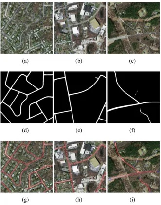
(a) (b) (c)
(d) (e) (f)
(g) (h) (i)
Fig. 1: Upper row: original satellite images; middle row: segmen-tation results from D-LinkNet34; bottom row: the results of road network extraction by the tube-MPP model.
The road segmentation results from these deep convolu-tional networks are impressive. These methods can overcome the problem of occlusions and shadows; see Fig 1 (d), (e). However, there still exist some road connectivity problems and incorrect detections, such as in Fig 1 (f). Moreover, the binary segmentation masks are not sufficient for higher level road analysis (such as obtaining certain statistical information
and analyzing the structure of the road network). Filin, Za-para and Panchenko [9] proposed a post-vectoring algorithm combined with their EOSResUNet to extract the roads as vec-tors. This partially solves the connectivity problem in small gaps but is not able to fill larger gaps or extend roads.
Unsupervised line network extraction by MPP is another choice for road detection. Lacoste, Descombes and Zeru-bia [10] proposed the Quality Candy model for line network extraction. Schmidt et.al [11] presented a forest point process for the automatic extraction of networks. We proposed in a previous paper [12] a connected-tube MPP model for strip feature extraction. These MPP based models provide good results in many cases, but they assume the gray level varia-tion between a road and the background is large, which is not always true.
Considering the promising road segmentation results from deep convolutional networks, we apply our connected-tube MPP model to the segmentation results. In this way, we accu-rately extract the roads as connected tubes, which can be used for higher level road analysis. Moreover, we propose a post road-tracking algorithm based on the extracted tube networks for solving road connectivity problems.
The remainder of this paper is organized as follows: In Section 2, we review the segmentation methods based on U-Net and the connected-tube MPP model. In Section 3, we introduce our tracking algorithm. In Section 4, road detection results from the Massachusetts roads dataset [13] are given and discussed. Finally, conclusions are drawn in Section 5.
Fig. 2:The architecture of U-Net.
2
Related Work
2.1
Road Segmentation with U-Net
The architecture of U-Net, as in Fig 2, mainly consists of an encoder part, a decoder part and shortcuts. In the encoder and decoder parts, there are 5 basic convolutional blocks each. If we add a residual connection between the input and output for each convolutional block, then we turn the UNet to ResUNet [5]. If we use the ResNet-34 pretrained on ImageNet dataset as the encoder, then the network becomes a LinkNet [14]. Then if we apply the dilation convolution [15] to the bridge part (the middle part of U-Net), the network turns into
D-LinkNet [8].
The training process for U-Net is tricky. First, data aug-mentation is essential for training the network. The com-mon augmentation strategies include flip, rotate, add noise and change illumination. The selection of loss function is also important. The BCE (binary cross entropy)+ dice coeffi-cient loss [8] works well for road segmentation. And Mosin-ska [16] proposed a loss function that is aware of the higher-order topological features of linear structures.
(a) (b)
Fig. 3:(a) The shape model of a tube; (b) Tracking illustration.
2.2
Connected-Tube MPP Model
Let Y denote the observed image, S the image lattice, S ⊂ IR2. A point process on S is a set of points {S1, S2, ..., Sn} ⊆
S, with the random variable Sirepresenting the random
loca-tion of the ith point. In a marked point process, for each point Si, there is an associated mark, which consists of random
variables from a mark space M describing an object located at point i. For our tube MPP model, the mark of a tube is defined by the vector (a, b, θ), as in Fig 3 (a). The random variables a, b are the major and minor axes, which control the size of the tube, and θ controls the orientation. The white region is the inner area, the red region is the outer area, which has width of 2 pixels, the blue region and the yellow region are the front connection area and back connection area, respectively. Mark space M = [amin, amax]×[bmin, bmax]×[0, π], for some
pa-rameters amin, amax, bmin, bmax. A marked object is defined
as a vector Wi = (Si, Mi) ∈ W , where W ⊆ S × M . Let
ΩW be the configuration space, which denotes the space of
all possible realizations of W . Then w = (w1, ..., wn) ∈ ΩW
is a possible object configuration, where n is the number of objects in this configuration. Then the density of the marked point process is given by
f (w|y) = 1
Zexp{−Vd(y|w) − Vp(w)} (1) where Z is the normalizing constant, Vd(y|w) is the data
en-ergy, which describes how well the objects fit the observed image. In this paper we apply the contrast based data en-ergy [17]. Vp(w) is the prior energy introducing the prior
the overlap prior, tube length prior and connection prior as in [12]. State transitions in the configuration space are real-ized by three types of kernel: Birth and death kernel, pertur-bation kernel and switch kernel.
After converting the output (a probabilistic image) of net-works from U-Net family to a binary image by a threshold, as in the images in Fig 1 (d), (e), (f), we take this binary image as the input to our connected-tube MPP model. Then we can extract the roads as a connected-tube network, as shown in Fig 1 (g), (h), (i).
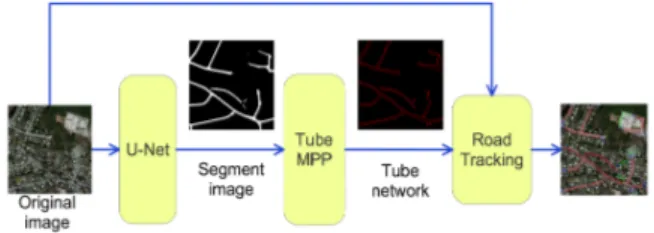
Fig. 4:The framework of the proposed method.
3
Road Tracking
In order to fill some gaps and large missing parts of roads in the segmentation result from deep learning, we propose a tracking algorithm that takes the connected tubes and the original image and extends roads using the method described in this section. The framework is shown in Fig 4.
The open and half open tubes in the extracted connected-tube networks are selected as tracking seeds, which are the tubes with blue edges in Fig 1 (i).
In our work, tracking roads is an iterative process. Given a tube object Pi, our goal is to find a Pi+1(as in Fig 3 (b))
which is connected to Pi, has similar features to Pi, and does
not conflict with other tube objects. We repeat this process until the whole road has been extracted.
We take the HSV histogram [18] of the inner area of the tube as the color feature Ciof a road segment. This feature is
updated in the tracking process by Ci= γCi−1+ (1 − γ)C,
where γ is the update ratio and C is the color feature of the inner area of the object being tracked. Within the tracking process, we calculate a tracking score T S for each potential tracking object. Tracking score is formulated as:
T S = ωcdist(Ci, C) − ωddist(C, Co) + ωoad (2)
where Cois the color feature of the outer area of the tracking
object; Ciis the color feature of the road in the ith step; ad is
the angle deviation from the original tube object; ωc, ωd, ωo
are weights; and dist(x, y) is the Euclidean norm function. The first term in (2) encourages the tracked object to have similar color to the previous road segments. The second term encourages the tracking object to have larger color difference between inner and outer areas. The third term penalizes the angle deviation.
The details of the tracking process can be seen in Algo-rithm 1.
Algorithm 1 Road Tracking Function
TrackingFunc(currentObj, colorfeature, TrackingArray): if currentObj’s front/back end is OPEN then
BestScore = 1000
A = currentObj’s front/back middle point for ad in range (−30, 30) do
for len in range (−2, 2) do newObj.a = currentObj.a+len
newObj.θ = (currentObj.θ + ang)%360 newObj’s back/front middle point = A T Snew= newObj’s score calculated by (2)
if T Snew<BestScore then
BestScore = T Snew
BestObj=newObj end if
end for end for
if BestScore< Tsand BestObj not overlap then
TrackingArray.add(BestObj)
colorf eature = BestObj.colorf eature ∗ (1 − γ) + colorf eature ∗ γ
TrackingFunc(BestObj, colorfeature, TrackingArray) end if
end if
4
Experiments
To demonstrate the performance of our method in high-resolution satellite images, we test it on the Massachusetts roads dataset1(with the resolution of 1.2 meter). We mainly
focus on its ability to extract roads as connected tubes and to solve connectivity problems in road segmentation. For quan-titative evaluation, the Jaccard index [19] (ie., Intersection over Union) is used. For sets A and B, it is defined as:
J (A, B) = |A ∩ B| |A ∪ B| =
|A ∩ B|
|A| + |B| − |A ∩ B| (3) We apply the D-LinkNet34 [8] for road segmentation and the tube-connected MPP model for road segment extraction. The parameters for the tube model are set as amin = 4, amax =
16, bmin = 2, bmax = 8. For our tracking algorithm, we set
ωc = 0.5, ωd= 0.3, ωo = 0.02, γ = 0.88, Ts= 0.38 by trial
and error.
In Fig 5, we present 5 test results to show our method can work for different connection problems. The 512 × 512 images are cropped from the test set in Massachusetts roads dataset. For the first test, we can see there are some small
1
Fig. 5: First column: original images; second column: the ground truth; third column: segmentation results from D-LinkNet34; fourth column: improved segmentation results by our tracking method; fifth column: road network detection results (red tubes are the extracted tubes from connected-tube MPP model; blue tubes are the tracking seeds; green tubes are the tracking tubes).
disconnection parts in the red circle and one segment of road lost in the green circle. In the second test, a small gap appears in the corner of two roads. In the third test, only the middle part of the road has been segmented out. For the fourth test, in the red circle the highway is not segmented out, and in the green ellipse, there is a disconnection problem. By running the proposed algorithm, the gaps have been filled. The fifth test is very challenging, since the missing part of the road in the red ellipse is heavily occluded by trees. With the same experimental parameters, our method would lose the part in the blue box due to heavy occlusion. When we increase the threshold Ts, we detect the whole road as Fig 5 shows. But if
we keep this high threshold, there could be some false alarms in other tests. The IoU of these tests are listed in Table 1.
5
Conclusions and Future Work
Road segmentation by deep learning method provide interest-ing results. However, it still exhibits some connectivity prob-lems and incorrect detection. To deal with the connectivity problems in road segmentation, we propose a post-processing method by combining the tube-connected MPP model and a tracking algorithm. This method not only relieves the
prob-lem of disconnection in road segmentation, but also can pro-vide a connected-tube network for higher level road analysis (such as obtaining the statistics of roads or road networks). The experiments on the Massachusetts roads dataset demon-strate the performance of our method. In future research, we will try to learn the parameters in our model automatically and test our method on other applications, such as blood ves-sel detection.
test1 test2 test3 test4 test5 DLinkNet34 0.495 0.600 0.607 0.344 0.460 Improved
by tracking
0.535 0.635 0.617 0.545 0.569
Table 1: IoU values of the tests in Fig 5.
6
Acknowledgments
J. Zerubia would like to thank the IEEE Signal Processing So-ciety for financial support as an IEEE SPS Distinguished Lec-turer in 2016-2017, which gave her the opportunity to meet with Prof. M. Comer and start this collaboration, and both Inria and Purdue for funding her visit to Purdue in 2018.
7
References
[1] C. Sujatha and D. Selvathi, “Connected component-based technique for automatic extraction of road cen-terline in high resolution satellite images,” EURASIP Journal on Image and Video Processing, vol. 2015, no. 1, pp. 8, Mar 2015.
[2] R. Alshehhi and P. R. Marpu, “Hierarchical graph-based segmentation for extracting road networks from high-resolution satellite images,” ISPRS Journal of Pho-togrammetry and Remote Sensing, vol. 126, pp. 245 – 260, 2017.
[3] V. Mnih and G. E. Hinton, “Learning to detect roads in high-resolution aerial images,” in European Conference on Computer Vision (ECCV), Berlin, Heidelberg, 2010, pp. 210–223, Springer.
[4] O. Ronneberger, P. Fischer, and T. Brox, “U-net: Con-volutional networks for biomedical image segmenta-tion,” in Medical Image Computing and Computer-Assisted Intervention (MICCAI), Cham, 2015, pp. 234– 241, Springer.
[5] Z. Zhang, Q. Liu, and Y. Wang, “Road extraction by deep residual u-net,” IEEE Geoscience and Remote Sensing Letters, vol. 15, no. 5, pp. 749–753, May 2018. [6] K. He, X. Zhang, S. Ren, and J. Sun, “Deep residual learning for image recognition,” in IEEE Conference on Computer Vision and Pattern Recognition (CVPR), 2016, pp. 770–778.
[7] A. V. Buslaev, S. S. Seferbekov, V. I. Iglovikov, and A. A. Shvets, “Fully convolutional network for automatic road extraction from satellite imagery,” IEEE/CVF Conference on Computer Vision and Pattern Recognition Workshops (CVPRW), pp. 197–1973, 2018. [8] L. Zhou, C. Zhang, and M. Wu, “D-linknet: Linknet with pretrained encoder and dilated convolution for high resolution satellite imagery road extraction,” IEEE/CVF Conference on Computer Vision and Pattern Recogni-tion Workshops (CVPRW), pp. 192–1924, 2018. [9] O. Filin, A. Zapara, and S. Panchenko, “Road
detec-tion with eosresunet and post vectorizing algorithm,” IEEE/CVF Conference on Computer Vision and Pattern Recognition Workshops (CVPRW), pp. 201–2014, 2018. [10] C. Lacoste, X. Descombes, and J. Zerubia, “Point pro-cesses for unsupervised line network extraction in re-mote sensing,” IEEE Transactions on Pattern Analysis and Machine Intelligence, vol. 27, Issue 10, pp. 1568– 1579, 2005.
[11] A. Schmidt, F. Lafarge, C. Brenner, F. Rottensteiner, and C. Heipke, “Forest point processes for the automatic extraction of networks in raster data,” ISPRS Journal of Photogrammetry and Remote Sensing, vol. 126, pp. 38–55, 2017.
[12] T. Li, M. Comer, and J. Zerubia, “A Connected-Tube MPP Model for Object Detection with Application to Materials and Remotely-Sensed Images,” in IEEE Inter-national Conference on Image Processing (ICIP). Oct. 2018, pp. 1323–1327, IEEE.
[13] V. Mnih, Machine Learning for Aerial Image Labeling, Ph.D. thesis, University of Toronto, 2013.
[14] A. Chaurasia and E. Culurciello, “Linknet: Exploiting encoder representations for efficient semantic segmen-tation,” IEEE Visual Communications and Image Pro-cessing (VCIP), pp. 1–4, 2017.
[15] F. Yu and V. Koltun, “Multi-scale context aggregation by dilated convolutions,” in ICLR, 2016.
[16] A. Mosinska, P. M´arquez-Neila, M. Kozinski, and P. Fua, “Beyond the pixel-wise loss for topology-aware delineation,” in IEEE Conference on Computer Vision and Pattern Recognition (CVPR), 2018, pp. 3136–3145. [17] X. Descombes, R. Minlos, and E. Zhizhina, “Object extraction using a stochastic birth-and-death dynamics in continuum,” Journal of Mathematical Imaging and Vision, vol. 33, Issue 3, pp. 347–359, 2009.
[18] S. Sural, G. Qian, and S. Pramanik, “Segmentation and histogram generation using the hsv color space for im-age retrieval,” in Proceedings. International Conference on Image Processing, Sep. 2002, vol. 2, pp. II–II. [19] L. Hamers, Y. Hemeryck, G. Herweyers, M. Janssen,
H. Keters, R. Rousseau, and A. Vanhoutte, “Similarity measures in scientometric research: The jaccard index versus salton’s cosine formula,” Inf. Process. Manage., vol. 25, no. 3, pp. 315–318, May 1989.