HAL Id: hal-00880413
https://hal.archives-ouvertes.fr/hal-00880413
Submitted on 27 Apr 2020
HAL is a multi-disciplinary open access
archive for the deposit and dissemination of
sci-entific research documents, whether they are
pub-lished or not. The documents may come from
teaching and research institutions in France or
abroad, or from public or private research centers.
L’archive ouverte pluridisciplinaire HAL, est
destinée au dépôt et à la diffusion de documents
scientifiques de niveau recherche, publiés ou non,
émanant des établissements d’enseignement et de
recherche français ou étrangers, des laboratoires
publics ou privés.
BP: Sedimentological, geochemical and botanical
markers of soil erosion recorded in a Mediterranean
alpine lake
Elodie Brisset, Cécile Miramont, Frédéric Guiter, Edward Anthony, Kazuyo
Tachikawa, Jérôme Poulenard, Fabien Arnaud, Claire Delhon,
Jean-Dominique Meunier, Edouard Bard, et al.
To cite this version:
Elodie Brisset, Cécile Miramont, Frédéric Guiter, Edward Anthony, Kazuyo Tachikawa, et al..
Non-reversible geosystem destabilisation at 4200 cal. BP: Sedimentological, geochemical and botanical
markers of soil erosion recorded in a Mediterranean alpine lake. The Holocene, London: Sage, 2013,
23 (12), pp.1863-1874. �10.1177/0959683613508158�. �hal-00880413�
Introduction
Soil erosion and degradation are often regarded as major charac-teristics of the Mediterranean area (García-Ruiz, 2010). Whereas questions remain open on the historical causes of modern gener-alised soil disequilibrium that lead to colluviation processes, a debate has begun regarding the respective importance of climatic and human factors in erosion processes (Roberts et al., 2011). Indeed, human practices and meteorological events are well-known factors forcing long-term soil erosivity and soil erodibility (Hatfield and Maher, 2009; Nearing et al., 2005; Strunk, 2003). However, deciphering these forcing factors over the Holocene period to provide new insight on landscape sensitivity and thresh-old effects remains a challenge (Butzer, 2005), especially in high-altitude areas where the climatic signal is amplified as a result of large topographical gradients (Beniston, 2003) and traditional land-use activities such as domestic livestock grazing, forest clearance and cultivation of marginal land (Röpke et al., 2011; Walsh et al., 2007). Palaeoenvironmental reconstructions can throw light on this debate provided they rely on accurate proxies and reliable chronologies.
Lake sediments are well-recognised archives that provide long-term perspectives in the deciphering of geosystem trajectories (Magny et al., 2013) by recording a broad range of proxies respond-ing more or less directly to changes in environmental conditions (Birks and Birks, 2006). One key advantage of this multiproxy approach is to avoid age–depth uncertainties when various environ-mental proxies are investigated on the same cored profile and at a
high temporal resolution (Fritz, 2008). This enables the determina-tion of a common time frame of geosystem changes, including those related to weathering and soil development as a measure of stability or instability (synchronism, time-gap, tipping point).
The geophysical and geochemical properties of lacustrine bulk sediments have been shown to be valuable in tracking erosion processes (Enters et al., 2008; Giguet-Covex et al., 2011;
1Aix-Marseille University, CNRS, IRD, Collège de France, UM 34
CEREGE (Technopôle de l’Arbois BP 80, 13545 Aix-en-Provence cedex 04, France)
2Aix-Marseille University, CNRS, UMR 7263 IMBE (Technopôle de
l’Arbois BP 80, 13545 Aix-en-Provence cedex 04, France)
3Université de Savoie, CNRS, UMR 5204 EDYTEM (Pôle Montagne
Campus scientifique, 73376 le-Bourget-du-Lac cedex, France)
4Université Sophia Antipolis, CNRS, UMR 7264 CEPAM (Campus
Saint-Jean-d’Angély, SJA3, 24 avenue des Diables Bleus, 06357 Nice cedex 04, France)
5Aix-Marseille University, CNRS, UMR 7299 CCJ (Maison
Méditerranéenne des Sciences de l’Homme, 5 rue du Château de l’Horloge BP 647, 13094 Aix-en-Provence, France)
Corresponding author:
Elodie Brisset, Aix-Marseille University, CNRS, IRD, Collège de France, UM 34 CEREGE (Technopôle de l’Arbois BP 80, 13545 Aix-en-Provence cedex 04, France).
Non-reversible geosystem destabilisation at
4200 cal. BP: Sedimentological, geochemical
and botanical markers of soil erosion
recorded in a Mediterranean alpine lake
Elodie Brisset,
1,2Cécile Miramont,
2Frédéric Guiter,
2Edward J Anthony,
1Kazuyo Tachikawa,
1Jérôme Poulenard,
3Fabien Arnaud,
3Claire Delhon,
4Jean-Dominique Meunier,
1Edouard Bard
1and Franck Suméra
5Abstract
A 144-cm-long core was obtained in Lake Petit (2200 m a.s.l., Mediterranean French Alps) in order to reconstruct past interactions between humans, the environment and the climate over the last five millennia using a multidisciplinary approach involving sedimentological, geochemical and botanical analyses. We show a complex pattern of environmental transformation. From 4800 to 4200 cal. BP, podzol-type soils progressively developed under forest cover. This stable situation was interrupted by a major detrital pulse at 4200 cal. BP that we consider as a tipping point in the environmental history. At this point, pedogenetic processes drastically regressed, leading to the development of moderately weathered soils. More frequent detrital inputs are recorded since 3000 cal. BP (ad 1050) as the human impact significantly increased in the catchment area. We conclude that destabilisation of the environment was triggered by climate and exacerbated by human activities to a stage beyond resilience.
Keywords
Ohlendorf et al., 2003) and changes in hydrolysis regimes involved in soil development (Arnaud et al., 2012; Koinig et al., 2003). Warm climatic periods potentially intensify chemical weathering (White et al., 1999), whereas forest vegetation is deemed to reduce soil erosivity (Kauppila and Salonen, 1997). The temporal variation of these weathering processes has been investigated through analysis of major and trace elements (e.g. Mourier et al., 2010). However, element analysis is extremely time-consuming, and this is an obstacle to systematic whole-core analysis. High-resolution measurement techniques have been developed in parallel with much less time-consuming devices. One routinely used technique is that of sediment magnetic proper-ties, which are in many cases characteristic of the detrital fraction (DF) and may reflect changes in particle size (Dearing et al., 2001; Oldfield et al., 2003). However, other sediment compounds and their elemental composition cannot be accessed using this technique. X-ray fluorescence (XRF) core scanning (Wilhelm et al., 2012) and Fourier-transform infrared spectroscopy (FTIRS; Vogel et al., 2008) offer fast tools to quantify at very high resolu-tion the elemental geochemistry (lithogenic major elements) and bulk composition (organic matter, biogenic silica), respectively.
For the first time in the southern French Alps, we used these techniques as part of a high-resolution multiproxy investigation of a core from an alpine Mediterranean lake (Figure 1) covering the last 5000 years. The altitudinal position of Lake Petit above the current treeline and the presence of archaeological remains of both pastoral and mining activities in the catchment offer excep-tional conditions for the investigation of past interactions between environment, climate and humans using the lake’s sedi-ment archive. Major elesedi-ments, biogenic silica and organic matter from the core were analysed and compared with pollen and botanical data in order to decipher changes in weathering and erosional regime in relation to climate fluctuations, slope vegeta-tion dynamics and human impact on the fragile mountain environment.
Study site
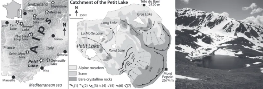
Lake Petit (2200 m a.s.l.) is a small circular lake (diameter: 150 m and depth: 7 m) in the southwestern extremity of the French Alps in the Mercantour-Argentera Massif (N 44°06.789; E 7°11.342; Figure 1). This glacier-inherited lake is surrounded by mountains reaching 2670 m, and is part of the Millefonts catchment. This region of the Alps is less than 40 km from the Mediterranean Sea and is influenced by both Mediterranean and continental alpine climates. Mean annual precipitation in the Mercantour Massif at
1800 m a.s.l. is about 1340 mm and mostly occurs as rainfall in spring and autumn. Snow covers the catchment c. 138 days per year. Mean temperatures range from 0.4°C in winter to 9.9°C in summer. The glacier-inherited catchment is characterised by gen-tle south-facing slopes (c. 20°) contrasting with north-facing ver-tical rock bars. The basement consists of Palaeozoic igneous rocks (gneiss and migmatite) mainly covered by scree. Lake Petit is the largest of four lakes seasonally connected by streams run-ning in scree and moraines. Lake Petit is connected to two water-seepage zones supplied by snowmelt during summer. In this part of the Alps, the Mediterranean and supra-Mediterranean vegeta-tion belts reach their highest altitudes (Ozenda, 1985). Within the study area, the treeline reaches 2100 m and is characterised by a sparse presence of larch. The slopes are covered by c. 40-cm-thick soils mostly developed on moraine deposits. We distinguish two types of soils in the Millefonts catchment. Soils developed under an alpine dry acidic meadow are characterised by a gradual transition between three silty-sand dry horizons that become richer in stones towards the deeper horizons (Cambisol (drystric) sensu IUSS Working Group WRB, 2006). Soils developed under dwarf shrub formations of Ericaceae are characterised by well-contrasted horizons from dark brown lumpy surface horizons to ochre silty-sand deeper horizons (Entic Podzol sensu IUSS Work-ing Groups WRB, 2006). At lower altitudes, the mountain vegeta-tion belt shows an alpine to Mediterranean combinavegeta-tion of species and is characterised mainly by Pinus cembra, Abies and Picea in association with Olea and Buxus.
Materials and methods
A 144-cm-long core (PET09P2) was retrieved from the deepest part of Lake Petit in 2009 using an UWITEC gravity coring sys-tem. The sediment core PET09P2 is composed of homogenous yellow to greenish diatomite with millimetre-thin brownish diato-mite-clay diffuse laminations. After core opening and lithological description, we continuously cut one of the core halves into 144 volumetric sediment samples to measure dry density (g/cm3) of the bulk sediment and to concentrate fossil sporo-pollinic content. The other half core was scanned with the XRF method in order to con-duct continuous semi-quantitative measurements of major ele-ments, further calibrated by quantitative concentration analysis.
Dating
210Pb and 137Cs short-lived radionuclide gamma decay was anal-ysed at a 1-cm interval over the uppermost 20 cm (Laboratoire de
Figure 1. Location map of the study site and other lake records referred to in the text, main geomorphological characteristics of the
catchment and photography of Lake Petit. (1) glacial cirque, (2) glacial step, (3) moraine, (4) polished bedrock, (5) active debris slope, (6) small dam built in 1947 and (7) photography viewpoint.
Glaciologie et Géophysique de l’Environnement (LGGE),
France). Seven 14C ages were obtained from terrestrial macro-remains throughout the core (Table 1), and dating was carried out by the Poznan Radiocarbon Laboratory. 14C ages BP were cali-brated using the IntCal09 calibration curve (Reimer et al., 2011). An age–depth model was computed using a monotonic smooth spline (type 4, smooth 0.3) on the clam module (Blaauw, 2010) taking into account the probability density function of the 14C ages.
Grain-size, organic matter, biogenic silica and major
elements
Grain-size distributions were measured by laser diffraction using a Malvern Mastersizer S at 5 mm intervals throughout the core. Samples were ignited at 550°C prior to grain-size analysis to remove organic matter. Distributions were standardised, and the deviation of the grain-size class [1.95, 2.28] µm was calculated to investigate abundance variation of clays. Total organic carbon (wt%TOC) was analysed on 24 samples by Rock-Eval Pyrolysis using a ‘Turbo’ Model RE6 pyrolyser (Institut des Sciences de la
Terre, Université d’Orléans (ISTO), France). Quantification of
biogenic silica was carried out on 28 discrete samples following wet-alkaline leaching according to DeMaster (1981). Dissolved silica concentration was measured using a molybdate-yellow spec-trophotometry with a Jasco V-650 Spectrophotometer. Three repli-cates were measured on five samples giving a mean standard error of 4.9%. Concentration of biogenic silica is expressed as %SiO2 biog (%SiO2 biog = 2.139 * %Siopal according to Mortlock and Froe-lich, 1989). Bulk sediment concentrations in SiO2, Al2O3, Fe2O3, MnO, MgO, CaO, Na2O, K2O, TiO2 and P2O5 were measured on 20 samples by mass spectrometry using an inductively coupled plasma–atomic emission spectroscopy (ICP-AES) Thermo X7 after LiBO2 alkaline fusion (Carignan et al., 2001; Murray et al., 2000) by the Service d’Analyse des Roches et des Minéraux (SARM) laboratory. Prior to the analyses, the aliquots were heated at 1000°C during 7 h, giving the loss-on-ignition weight. Abun-dances of major elements are expressed as oxide weight percent-ages (wt%). The DF of SiO2 (SiO2 detr) is calculated assuming a constant ratio between aluminium and silica detrital phases in the upper continental crust ((Si/Al)UCC = 3.83; McLennan, 2001) as:
SiO2detr
(
wt %)
= Al O% 2 3 Sediment*(
Si Al/)
UCC The total DF (%DF) is calculated as the sum:DF wt SiO Al O Fe O
MnO MgO CaO
2 2 3 2 3 % % % % % % %
(
)
= + + + + + + detr Na O K O TiO P O 2 2 2 2 5 % % % % + + +As the dilution effect between biogenic silica and the detrital silicate phase is predominant, we investigated the chemical com-position of the detrital silicate phase. The XSilicate (mol/100 g) is the abundance of the element X in the DF:
XSilicate=X DF /
( )
%To investigate the chemical composition of the detrital phase, we used the Chemical Index of Alteration (CIA; Nesbitt and Young, 1982): CIA Al O Al O CaO K O Na O 2 3 2 3 2 2 % % / % % % %
( )
= + + +(
)
High-resolution analysis
To achieve high-resolution analysis, within-core calibrations were constructed using quantitative discrete samples. We used the FTIRS method (Vogel et al., 2008) to predict SiO2 biog and TOC. Measurements were carried on a Nicolet 380 Smart Diffuse Reflectance spectrometer on 144 samples providing continuous resampling at cm-resolution. XRF core scanning was carried out using an ITRAX Core scanner. Relative element abundances of K, Ti, Fe, Rb, Si and Ca were measured using a molybdenum source at an increment of 2 mm over an integration time of 60 s (40 kV and 35 mA).
Pollen analysis
Pollen chemical extraction was conducted following the proto-col of Bennett (1990) on 117 volumetric samples. Taxonomic identification was performed under a 500× magnification oil immersion microscope using identification keys (Moore et al., 1991) and photographs (Reille, 1995). A minimum of 300 pol-len grains were counted. Taxa percentages were calculated on the total pollen sum. We present selected pollen taxa that are characteristic of local pollen rain. Pollen of Rumex, Urtica,
Mentha, Plantago lagopus, Plantago lanceolata, Plantago coronopus, Plantago major and the Chenopodiaceae are
summed to synthesise the anthropogenic-related taxa. The abundance of Botrychium spores is expressed in sediment con-centration. Microfossils of Pinus tracheid and conifer stomata were also considered. The pollen diagram was plotted using the software C2 (Juggins, 2007).
Results and interpretation
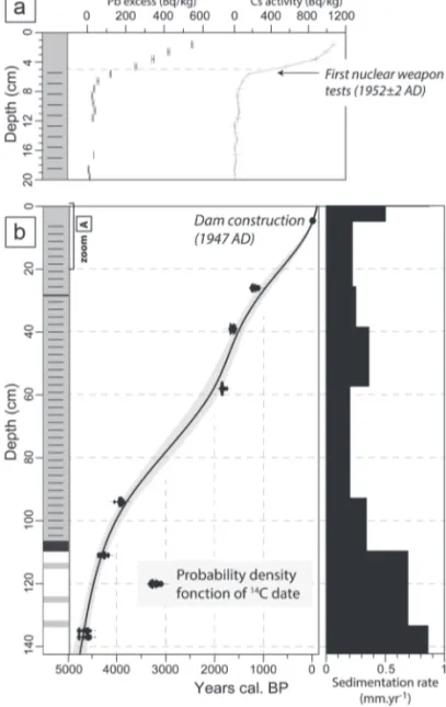
Chronology
The 210Pb and 137Cs profiles show a common pattern (Figure 2a). The top 5 cm are enriched in radionuclides, and the values drop to nil concentrations deeper down the core. Possible vertical sedi-ment mixing (e.g. bioturbation) could explain the flattening in the top 5 cm of radionuclide activity. Assuming a constant initial 210Pb concentration and constant accumulation rate (CFCR model; Rob-bins, 1978), the mean sedimentation rate is estimated at 0.7 mm/yr. This value is in agreement with the beginning of nuclear weapons testing and the associated 137Cs pollution (ad 1952 ± 2; Longmore, 1982) at 5 cm depth. Disappearance of laminations in the top 5 cm may be the sedimentological expression of the small dam
Table 1. Radiocarbon ages of core PET09P2. The maximum probability 14C age is typed in bold between the 2σ interval.
Depth (cm) Laboratory code 14C age BP 2σ calibrated age (cal. yr BP) 2σ calibrated age (cal. yr ad/bc) Material
26 Poz-32578 1240 ± 40 1068 (1175) 1270 ad 680 (ad 775) ad 882 Terrestrial debris
39 Poz-39213 1720 ± 30 1554 (1680) 1704 ad 246 (ad 270) ad 396 Wood – Larix
58 Poz-35509 1890 ± 30 1733 (1825)1894 ad 56 (ad 125) ad 217 Wood – conifer
94 Poz-32576 3620 ± 40 3835 (3910) 4080 2131 bc (1960 bc) 1886 bc Terrestrial debris
111 Poz-35507 3855 ± 35 4155 (4250) 4411 2462 bc (2300 bc) 2206 bc Scale – conifer
135 Poz-39212 4125 ± 35 4528 (4610) 4820 2871 bc (2660 bc) 2579 bc Twig – Ericaceae
constructed at Lake Petit in ad 1947 (Beniaminio, 2006). The 210Pb
and 137Cs data are consistent with such an interpretation. This may signify that the sedimentation rate changed at 5 cm, which pre-vents extrapolation of the 210Pb sedimentation rate deeper. Hence, the PET09P2 age–depth model (Figure 2b) has been constrained at 5 cm up to the year ad 1947 and by the seven 14C ages in Table 1.
The Lake Petit record covers the last 4700 years. The sedimenta-tion rate is relatively low between 5 and 105 cm (mean 0.24 mm/ yr). Higher sedimentation rates are recorded from 0 to 5 cm (0.5 mm/yr) and from 105 to 144 cm (0.64 mm/yr).
Calibration models of TOC, SiO
2 biog, DF and CIA
Two partial least squares (PLS) models were built in order to predict %SiO2 biog and %TOC using the FTIR spectra at a resolu-tion of 1 cm. The within-core FTIRS-inferred (−FTIRSinf) mod-els (see Supplementary Materials 1, available online, for details on these calibration models) have a significant quality of adjust-ment (%SiO2 biog − FTIRSinf: r2 = 0.80, standard deviation error of residuals (SDEres) = 5.99%, n = 28, %TOC-FTIRSinf: r2 = 0.94, SDEres = 0.62%, n = 24). Although the results of opal con-centration between FTIRS and conventional leaching technique present a reasonable agreement, the estimates based on FTIRS exhibit lower intensity in variations. The observed offset could be related to the fact that some of the refractory forms of amor-phous silica could be dissolved by leaching (Saccone et al.,
2007), whereas biogenic silica could be confounded with other compounds absorbing in the same infrared region (Rosen et al., 2010).
The XRF element profiles were compared to the results obtained by quantitative measurements (ICP-AES) of discrete samples (n = 20) collected within the core. Large variations in dry density were observed, ranging from 0.1 to 0.6 g/cm3, with low values in diatom-rich units and high values in more clayey sediment. Changes in dry density have been pointed out as inducing important scatter bias in cross-plots of XRF core scan-ner outputs and element concentrations. Weltje and Tjallingii (2008) propose a calibration model based on the log-function of the XRF output intensities, which reduces the sensitivity to the dilution effect. XRF intensities of lithogenic elements K, Ti, Fe and Rb are highly cross-correlated (minimum cross-correlation = 0.92). Since Ti shows a good signal-to-noise ratio, it was used as a DF proxy. Titanium dioxide (TiO2) and %DF are highly related (r2 = 0.99). Ln(Ti/Si) is correlated to the %DF (n = 20,
r2= 0.89, SDE
res = 5.4%; see Supplementary Materials 2, avail-able online, for details on these calibration models). Since varia-tions in calcium content provide the clearest indicavaria-tions on the CIA index (alone, CaO explains 81% of the CIA variance), we hypothesise that the Ln(Ti/Ca) ratio could summarise the CIA index information. The relationship between the Ln(Ti/Ca) XRF intensities and the CIA is linear and positive, and both are highly related (n = 20, r = 0.90).
Bulk sediment composition
Core PET09P2 (Figure 3a) is organic-rich (9% mean of TOC) and has a high abundance of mainly biogenic silica (mean 65% of SiO2 biog). Important differences in dry density are observed between the diatom-rich sediment (0.15 g/cm3) and the most clayey unit (0.7 g/cm3). All grain-size samples show bimodal dis-tributions mainly characterised by well-preserved diatoms at 25 µm (Pseudostaurosira robusta and Staurosirella pinnata are the most common species) and diatom fragments (~0.4 µm).
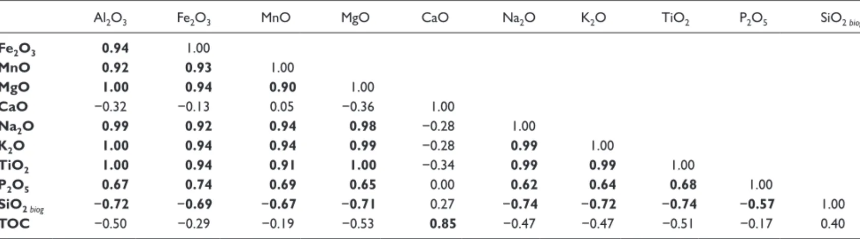
The cross-correlations (Table 2) between Al2O3, Fe2O3, MnO, MgO, Na2O, K2O, TiO2 and P2O5 are highly positive and represent the lithogenic DF (%DF). Lithogenic elements are negatively correlated with SiO2 biog and to lesser extent with TOC content. The TOC concentration is partly negatively related to lithogenic compounds (Table 2). TOC is a mixture of terrestrial and lacustrine organic debris (presence of diatoms, green algae, chironomid head capsules, wood fragments, spores, pollen and amorphous soil particles). CaO is not correlated with the other lithogenic elements (Table 2). As shown by the absence of absorbance in the carbonate-related bands in infrared spec-troscopy, we postulate that the sediment is carbonate-free in agreement with the igneous catchment geology. Hence, CaO concentrations are related to the lithogenic fraction but present a different pattern compared to other lithogenic elements. The concentration of %DF increases from the bottom to the top of the core (20–50%, respectively; Figure 3a). At 104–112 cm, %DF shows peaks of up to 90%. In contrast to %DF, %SiO2 biog decreases from c. 70% at depths of 120 cm to c. 30% at this depth. The geochemical composition of sediment is primary controlled by dilution effects between the TOC, the biogenic silica and the clay minerogenic inputs.
Element abundance within the DF
Figure 3b depicts element concentration within the total DF. The elements are grouped into two main negatively correlated (r = −0.9) compositional phases: [Al, Ti, Mg, Na, K] and [Ca, Fe, Mn, P]. Al is strongly correlated to Ti (r = 0.94), a relatively inert lithogenic element (Mackereth, 1966), and represents the
Figure 2. Age–depth relationship and sedimentation rate of core
PET09P2. (a) 210Pb and 137Cs levels in the uppermost 20 cm and (b) age–depth model (black line) and the 95% confidence interval (grey envelope).
alumino-silicate phase. The transition between Units I and II (Figure 3b) is characterised by a strong decline in concentrations of [Ca, Fe, Mn, P] that contrasts with the increase of the alumino-silicate phase (Figure 3b). At lower magnitudes, Mg, K, Na and Ti accumulated in the DF of the sediment compared to Al in Unit I. The CIA of Unit I (64%) is similar to the signature of poorly altered igneous rocks rich in primary minerals (Nesbitt and Young, 1982). From Unit I to Unit II, CIA increases from 64% to 72% (Figure 3a). This transition is not associated with modifica-tion of grain-size, and only the abundance of occupied volume by class varies (especially in the class 1.95–2.28 µm). The litho-genic fraction in Units II, III and IV has a signature of poorly altered secondary minerals (mean CIA of 72%; Nesbitt and Young, 1982). A noteworthy maximum value of CIA (75%) in Unit II indicates the highest alteration degree of the DF through-out the sequence.
Vegetation changes
The pollen record (Figure 4) is dominated by the Pinus sylvestris-type with relative frequencies varying from 30% to 60% of the total pollen count. Pollen of Pinus are often over-represented in temperate mountain environments because of its very large wind-dissemination and massive production (Coûteaux, 1982). As a result, the Pinus curve must be interpreted with caution since its over-representation may be accentuated in open grassland envi-ronments. Nevertheless, terrestrial macro- and microfossils of trees and shrubs (wood, twigs, barks, leaves and needles, Pinus tracheid and conifer stomata) found in the sediment core are good indicators of the local presence of woodlands or at least of iso-lated trees such as larch and pine (P. sylvestris and/or Pinus
unci-nata and P. cembra) between 4800 and 1500 cal. BP.
The Local Pollen Assemblage Zone I (LPAZ 1) is dominated by arboreal pollen (60%). Conifer trees were present in the lake
Figure 3. (a) Lithostratigraphy and vertical profile of bulk sediment: (1) pure diatomite, (2) diatomite-clay, (3) clay-diatomite and (4) diffuse
laminations. Diamond dots correspond to quantitative values used to model calibration (line) for TOC, SiO2 biog and detrital fraction. The CIA is plotted against the raw data Ln(Ti/Ca). (b) Harker’s diagram of major element concentration (mol/100 g) versus aluminium (mol/100 g) within the terrigenous fraction.
catchment as attested by repeated occurrences of conifer tracheid and stomata. Ericaceae, Poaceae and Caryophyllaceae percent-ages (Figure 4) are low, but continuous and Botrychium lunaria spores are present in very low concentrations (c. 4400 spores/ mL). B. lunaria is a fern typical of mountain grassland communi-ties growing on thin, poorly developed siliceous soils. Vegetation around the lake at this time was probably dominated by shrubs and grasses organised in patches composed of Caryophyllaceae (predominance of Cerastium), Poaceae, B. lunaria and Ericaceae associated with anthropogenic taxa that might indicate the pres-ence of pastoralism or slight clearing of the landscape.
The LPAZ II is characterised by a transitional decrease to 50% of the arboreal pollen, but the frequency of the P. sylvestris-type remains high (30%). Ericaceae, Poaceae and anthropogenic taxa show low frequencies. The local vegetation composition remains
relatively unchanged relative to the previous LPAZ but Caryo-phyllaceae and Botrychium taxa exhibit exceptionally high values of up to 14% and 4400 spores/mL, respectively (Figure 4).
In the LPAZ III, arboreal pollen remains are dominant, and conifer macrofossils are still present. From 4100 to 2700 cal. BP, an increase of Poaceae to 10% suggests a significant opening up of the vegetation in the upper valley. Whereas the pollen curve of
P. sylvestris increases, Ericaceae reaches an optimum,
contempo-raneous with the first occurrences of Cerealia, and a rise in the anthropogenic pollen curve and type is recorded.
The LPAZ IV is characterised by a decline in tree taxa to 50% and an increase of Poaceae and Caryophyllaceae. The severe decline of Pinus together with the absence of ligneous macrofossils suggests that the catchment has probably been treeless since 1300 cal. BP. Moreover, high frequencies of ruderal–anthropogenic
Table 2. Correlation matrix of concentration in major elements (ICP-AES measurements) and TOC. 1% significant correlation coefficients are
shown in bold, n = 20.
Al2O3 Fe2O3 MnO MgO CaO Na2O K2O TiO2 P2O5 SiO2 biog
Fe2O3 0.94 1.00 MnO 0.92 0.93 1.00 MgO 1.00 0.94 0.90 1.00 CaO −0.32 −0.13 0.05 −0.36 1.00 Na2O 0.99 0.92 0.94 0.98 −0.28 1.00 K2O 1.00 0.94 0.94 0.99 −0.28 0.99 1.00 TiO2 1.00 0.94 0.91 1.00 −0.34 0.99 0.99 1.00 P2O5 0.67 0.74 0.69 0.65 0.00 0.62 0.64 0.68 1.00 SiO2 biog −0.72 −0.69 −0.67 −0.71 0.27 −0.74 −0.72 −0.74 −0.57 1.00 TOC −0.50 −0.29 −0.19 −0.53 0.85 −0.47 −0.47 −0.51 −0.17 0.40
ICP-AES: inductively coupled plasma–atomic emission spectroscopy; TOC: total organic carbon.
Figure 4. Simplified pollen diagram from core PET09P2. Only local main pollen taxa are represented in relative frequencies. The exaggeration
dot line multiplies the relative frequency by a factor of 5. Conifer microfossils represent the occurrence of Pinus tracheid and/or conifer stomata. Tree/shrub macrofossil class comprises conifer-tree species as well as indeterminable conifer twigs, barks, needles and leaves (including possible shrubs such as Juniperus), and shrubs of Ericaceae.
grasses confirm the dominance of a grassland environment around the lake, with some markers of nitrogen enrichment of soils, such as
Urtica (higher than 10%), suggesting intense local grazing.
Discussion
From 4800 to 4200 cal. BP: a mature geosystem on
borrowed time
Botanical, sedimentological and geochemical analyses allow us to investigate the relationship between erosional patterns in the Lake Petit catchment and vegetation dynamics over the last 4800 years (Figures 5 and 6). From 4770 to 4350 cal. BP, the local
presence of woodlands is attested by a pollen percentage of trees of 60%, by conifer microfossils and by some macrofossils found in the sediment (Betula sp. at 142.5 cm in PET09P2). A macrofos-sil of Larix retrieved in coring of riverine peat in another nearby lake, Lake Long (2350 m; Figure 1) has been 14C-dated 3940 ± 30 BP (4510–4260 cal. BP; Suméra and Geist, 2010). The develop-ment of larches and pines in association with shrubby patches of Ericaceae (macrofossils in PET09P2 at 135 cm) might have led to the accumulation of a humus layer favouring progressive soil development (Figure 5). In Unit I of Lake Petit, the terrigenous flux is close to zero, suggesting that mobile element enrichment prevailed, with elemental soil loss over this period occurring in
Figure 5. Sketch of evolutionary scenario of soil/vegetation cover interactions recorded in Lake Petit sediments throughout the mid- to
soluble form due to the chemical weathering of primary minerals in the subalpine soil. High diatom abundance (70%) and remark-ably high values of TOC (15%) suggest that Si and organic matter were subsequently trapped in the lacustrine ecosystem. Conifer forests on podzols lead to organic matter accumulation and
development of mor-type humus, producing organic acid which promotes chemical weathering (Egli et al., 2009). A similar pedo-genetic fingerprint in lacustrine sediment has been observed in Lake Thyl and Lake Loup, in the central western Alps (Mourier et al., 2010), where element enrichments (rare earth elements and
Figure 6. Main geochemical and botanical proxies of core PET09P2 compared with hydrological conditions of (1) Magny et al. (2012a), (2)
Goehring et al. (2012) and (3) Drysdale et al. (2006). Number of 14C dates (2σ) in archaeological stratigraphy in the Southern Alps: (4) Suméra et al. (2008), (5) Morin and Rosenthal (2002) and (6) Walsh et al. (2007).
secondary Al-/Fe-bearing phase in this case) are due to soil acidi-fication during podzolisation of preexisting soils under arolla pine forests, while gyttja accumulated in the lakes.
Multiproxy lake sediment studies covering the Holocene period in high-altitude sites of the Alps highlight a common opti-mum of soil development with a dominantly conifer-tree forest. Poulenard (2011) has termed this particular phase the ‘Holocene Pedogenetic Optimum’. This phase ends at 6500 cal. BP in Lake Thyl (Mourier et al., 2010), 5550 cal. BP in Lake Anterne (Giguet-Covex et al., 2011), 5000 cal. BP in Meidsee (Thevenon et al., 2012), 4500 cal. BP in Lake Loup (Mourier, 2008), 3700 cal. BP in Sägistalsee (Koinig et al., 2003) and 3500 cal. BP in Unterer Landschitzsee (Schmidt et al., 2002; Wick et al., 2003). Mourier (2008) suggests that the maturing and persistence of soils might have been constrained by long-lasting favourable conditions, that is, a warmer climate, low runoff and low anthropogenic pressure. Local bioclimatic and anthropogenic settings and thresholds could explain asynchronous timings of this phase.
From 4200 cal. BP to present: beyond the resilience
of the geosystem
Activation of soil erosion and degradation of vegetation cover. The switch from Unit I to Unit II at 4200 cal. BP is recorded by an increasing DF (Figures 5 and 6). Higher values of CIA in Unit II indicate moderate weathering of the parental material. This major change in geochemical regime suggests a drastic modification in pedogenetic processes from progressive development of soils (podzol-type) before 4200 cal. BP to erosion or soil denudation processes. At 4200 cal. BP, runoff, possibly due to more intense precipitation, may have been so frequent as to result in only mod-erate weathering, thus favouring the development of Cambisols, such as those currently found around Lake Petit. This hypothesis is supported by the simultaneous over-representation of very low-dispersal alpine meadow pollen of Caryophyllaceae and
Botrychium spores (Figure 6). This type of erosive pattern is
rarely identified in pollen records. A high abundance of these taxa concomitant with a detrital pulse attests to erosion of both litter and subsurface soil horizons, probably through sheet erosion pro-cesses (Figure 5). However, Lake Grenouilles, close to Lake Petit, also recorded a fall in arboreal pollen together with high percent-ages of low-dispersal alpine meadow taxa such as Poaceae, Che-nopodiaceae and Caryophyllaceae (Kharbouch, 2000). Over this period, a lowering of the percentages of Larix may be interpreted as local deforestation favouring the renewed growth of alpine meadows, possibly over-represented as a result of sustained intense runoff on catchment slopes.
The high temporal resolution data obtained at Lake Petit pro-vide epro-vidence of an alpine geosystem capable of tipping rapidly and irretrievably. The system turned from a steady-state without soil erosion (Unit I) to a new state dominated by a degradation trend for both slopes and vegetation cover (Figure 5). From the tipping point (4350 cal. BP), represented by increasing terrige-nous inputs, a new sedimentary regime under continuous erosive control has been maintained until today, without any transitional phase of soil stabilisation (uninterrupted soil erosion: Units II, III and IV; Figure 6).
Slopes under anthropogenic pressure? The aforementioned soil
erosion trend may be linked to an increase in anthropogenic pressure. Indeed, since c. 5000 cal. BP in both the Northern (Curdy, 2007; Krause, 2007) and Southern Alps (Mocci et al., 2008; Walsh et al., 2007), abundant archaeological evidence of repeated seasonal pastoral activities (enclosures for herds with adjacent smaller domestic living areas) has been found at alti-tudes exceeding 2000 m (Figure 6). Lake Petit recorded between
4770 and 4300 cal. BP, a continuous presence of alpine grass-lands characterised by high percentages of ruderal taxa (Figure 6), such as Rumex and Plantago sp., signifying that local grazing activities occurred in the catchment. As attested by the thousands of carved rocks in the Mount Bego region (20 km distant from Lake Petit), transhumant pastoralism may have started during the Chalcolithic and the ancient Bronze Age (De Lumley and Echas-soux, 2009). Although these changes involved human activities and the vegetation cover, no significant soil erosion occurred until 4200 cal. BP. However, starting from 3000 cal. BP (late Bronze Age), intensified pastoral activities appear to have strongly modified the landscape as anthropogenic grasslands, together with Ericaceae shrublands, progressively developed in association with poorly developed soils (Figure 5). At this time, the detrital input increased slightly. Finally, a rapid development of anthropogenic grassland communities between 1800 cal. BP and 500 cal. BP attests to a local upswing in human pressures on the Lake Petit catchment. Land-use changes were not accompa-nied by a significant increase in TOC concentrations (nor in TOC flux), which could have been an effect of long-lasting depletion of soil organic carbon. Further analyses on nutrient availability will be needed to verify this hypothesis. Maximum human pres-sures indicated by pollen coincide with evidence of pastoral and mining activities in the Lake Petit catchment. Ongoing 14C inves-tigations on archaeological remains indicate mining activity between 2200 and 1600 cal. BP (Morin and Rosenthal, 2002; Pagès, 2009), and excavated stratigraphies on pastoral enclo-sures attest to the presence of shepherds and livestock between 1000 and 400 cal. BP (Suméra et al., 2008). As a result, from 3000 cal. BP to present, soils lost protection from the arboreal cover, and were probably (1) compacted by domestic livestock and (2) recurrently eroded by runoff intensified by general defor-estation for pastoral and mining purposes. Regarding this period, it must be noted that soil erosion remained regular but limited compared to the detrital pulse at 4200 cal. BP, although human disturbances had intensified. Therefore, even though human activities have had a direct impact on persistent sediment avail-ability at least since 3000 cal. BP, human pressures do not explain the sharp change in soil cover at 4200 cal. BP.
Increasing erosivity and sediment transfer under climatic control?
At the millennium scale: influence of Neoglacial climatic
change
. At c. 4000 cal. BP (corresponding to the onset of the so-called Neoglacial period), there is a general agreement in the cli-matic archives regarding an increase in humidity and cooling temperatures as shown by glacier advance (Goehring et al., 2012; Holzhauser et al., 2005) and treeline regression (Nicolussi et al., 2005) throughout the Alps and the northern Mediterranean (Zanchetta et al., 2012). Water-levels in many lowland lakes of western Europe (Lake Cerin, Magny et al., 2012a; Lake Bourget, Magny et al., 2012b) and in the northern Mediterranean (Lake Saint Léger, Digerfeldt et al., 1997; Lake Accesa and Lake Ledro, Magny et al., 2012a) exhibit a slight transition from low stands before ~4200 cal. BP to higher levels (Figure 6) thereafter, which indeed could suggest a common climatic forcing factor towards wetter conditions at c. 4200 cal. BP. Orbital changes involving both a general gradual decrease in summer insolation and a major reversal in insolation seasonality (Berger and Loutre, 1991) might have led to a more southward position of the Westerlies (Magny et al., 2011) and to wetter conditions over Europe (Andresen and Björck, 2005; Hughes et al., 2000; Larsen et al., 2012). These climatic changes have been used to subdivide the Holocene into mid- and late Holocene (Walker et al., 2012).The expression of this long-term regional-scale climatic influ-ence might be more contrasted in alpine Mediterranean highlands where climatology is characterised by high inter- and intra-annual
variability in precipitation. Situated at 1308 m in the Southern Alps, Lake Saint Léger has recorded a lowering of its level since 4100 cal. BP, reaching a lowest level between about 3500 cal. BP and 2600 cal. BP (Digerfeldt et al., 1997). According to the syn-thesis of Muller et al. (2012), many lakes in the Southern Alps (ranging from 950 to 1800 m a.s.l.) experienced complete drying out between 6600 and 2500 cal. BP. This trend has been due to high autochthonous organic production and possibly seasonal changes towards drier conditions in winter and/or warmer condi-tions in summer. Arguments in favour of seasonal change are also supported by a strong decrease in sedimentation rates in fluvial systems of the Southern Alps (Miramont et al., 2008).
At Lake Petit, the bipartition from the mid- to late Holocene can be clearly identified by soil cover modification and linked with a change in precipitation regime. Therefore, it can be assumed that wetter conditions might have played a major role in frequent sediment transfers to the lake. However, can a progres-sive change in the rainfall regime explain the state of no return of extremely sensitive soils?
The 4
.2 ka event: an environmental crisis at Lake Petit? Anabrupt climate pulse and/or rapid environmental changes have been identified around 4200 cal. BP in the Northern Hemisphere (Booth et al., 2005; Huang et al., 2011; Magny et al., 2009, 2012b; Staubwasser et al., 2003) and regionally in the northern part of the Mediterranean basin (Bruneton et al., 2002; Drysdale et al., 2006; Miramont et al., 2008). This event could correspond to the over-represented alpine meadow pollen zone of Lake Grenouilles according to an earlier 14C age of 4700 ± 60 BP (5310–5580 cal. BP) obtained by Kharbouch (2000). At Millefonts, the transition from stable soils (Unit I) to permanent soil erosion (Units II, III and IV) is expressed by a sharp increase in terrigenous inputs at 4300 cal. BP. According to the age–depth model (Figure 2), this detrital pulse occurred between 4430 and 4055 cal. BP (2σ inter-val), which means that the event duration did not exceed 375 years. This detrital event profoundly increased slope sensitivity to erosion processes compared to the impact of the period of increas-ing human pressure (from 3000 cal. BP to present and in particu-lar during the Mediaeval Period). Consequently, the hypothesis of a local but intense human impact during a short period is uncon-vincing to explain alone the severity of soil destabilisation. Besides, the speleothem record of the Buca della Renella cave in mid-latitude Italy (Drysdale et al., 2006 and Figure 6) indicates that a severe drought occurred between c. 4100 and 3800 cal. BP. The pollen diagram of Lake Petit does not show any significant evidence for a strong reversal in vegetation dynamics that could indicate a direct response to reduced moisture. Increase in dry density and increasing soil erosion could be indirect responses to long-lasting drought conditions in the catchment, which may have led to lake-level lowering during periods of earlier spring snowmelting. Hydrological changes could have been a direct response to this abrupt climate event. This hypothesis requires testing in the future. Finally, smooth changes in precipitation regime do not explain more satisfactorily the ‘environmental cri-sis’ signature recorded at 4200 cal. BP. The abrupt pulse recorded in Lake Petit could indirectly correspond to a ‘rapid’ climatic oscillation, within a background of both ‘smooth’ anthropogenic pressure and ‘smooth’ orbitally induced climate change at the mid- to late-Holocene transition.
Conclusion
For the first time in the southern French Alps, a high-resolution multiproxy investigation involving sedimentological, geochemi-cal and botanigeochemi-cal data has enabled a detailed 5000-year recon-struction of the dynamics of a fragile alpine ecosystem. At Lake Petit, the outstanding quality of the diatomite-rich sedimentary
archive was a major advantage for tracking any detrital pulse and/ or regime that occurred during the second half of the Holocene. Therefore, four main periods have been identified.
The period from 4800 to 4200 cal. BP is characterised by low physical weathering of silicates and presence of conifer woodlands, while pure diatomite was deposited in the lake. This stable phase of progressive soil development is characteristic of the Holocene Pedogenetic Optimum. An abrupt detrital event at 4200 cal. BP could be the indirect response of the local environment to the rapid climate oscillation of the 4.2 kyr event. The period from 4200 to 3000 cal. BP following this abrupt detrital event was marked by long-lasting soil erosion and anthropogenic disturbances, leading to a major pedogenetic process reversal towards poorly weathered soils. The period from 3000 cal. BP to present was characterised by peak anthropogenic pressure. The erosion dynamic induced at the onset of this phase has been continuous, without any transitory phase of soil stabilisation, and it still prevails today.
We have shown that the degradation of such an environment might have been more complex than hitherto assumed. The dynamics of the Lake Petit catchment were not driven by long-lasting disturbances but possibly by concomitant rapid changes in climate and smooth anthropogenic disturbance. Indeed, as the threshold of resilience was reached at 4200 cal. BP, the soil around the lake seemed to have become progressively trans-formed while human activities were on the rise. Over the last 2600 years (around 4000–1300 cal. BP), this fragile equilibrium between human-induced erosion and the persistence of degraded soils might have lasted before being terminated undoubtedly dur-ing the Middle Ages. From that period, anthropogenic pressure reached its maximum in the vicinity of the lake, inducing the last recorded stage of degradation of the environment.
Therefore, since 4200 cal. BP, the breakdown occurred in two steps: the first rapid phase (possibly climate driven) triggered weaknesses that made the system more vulnerable to agro-pastoral pressure which occurred during the second phase. Moreover, since this tipping point, the geosystem might have no longer been subjected to a seasonally contrasted Mediterranean climate regime. As a result, Lake Petit history illustrates clearly how the response of a geosystem facing both climate and human impact could be non-linear. The debatable question of the ‘weight’ of the human-triggered soil erosion after 4200 cal. BP can be broadened to include the current problem of global change and the role of human activities, at both local and global scales. Is climate change threatening to the resilience of environments? Is human impact weakening these environments in the face of climate change? Both questions might find answers in sediment archives such as those of Lake Petit.
Acknowledgements
We thank J-R. Disnar (ISTO, France) for the Rock-Eval Pyrolysis measurements, O. Magand (LGCE, France) for 137Cs and 210Pb isotopes analyses and M. Garcia (CEREGE, France) for manag-ing the XRF core scanner measurements. The ICP-AES mea-surements were performed by the CNRS Service d’Analyse des
Roches et des Minéraux (SARM laboratory, France). We thank
the association AMONT, E. Malet (EDYTEM, France) and B. Wilhelm (GeoAzur, France) for their help during the coring. We thank R. Cartier (IMBE/CEREGE, France) and C. Paillès (CEREGE, France) for the preliminary diatom determinations. This manuscript benefited from fruitful discussions with F. Mocci (CCJ, France) and G. Pagès (LAPA, France), and from the stimu-lating comments of two anonymous reviewers.
Funding
Data analysis and fieldwork were supported by FEDER funds through the PIT Mercantour programme (Parc National du
Mercantour, France) coordinated by F. Suméra (CCJ, France), and the LADICIA programme coordinated by C. Miramont (Ré-gion PACA, France). The PhD thesis of E. Brisset is funded by the Région PACA (France).
References
Andresen CS and Björck S (2005) Holocene climate variability in the Denmark Strait region – A land-sea correlation of new and existing climate proxy records. Geografiska Annaler – Series A: Physical Geography 87(1): 159–174.
Arnaud F, Révillon S, Debret M et al. (2012) Lake Bourget regional ero-sion patterns reconstruction reveals Holocene NW European Alps soil evolution and paleohydrology. Quaternary Science Reviews 51: 81–92.
Beniamino C (2006) Le Valdeblore et l’eau des lacs des Millefonts.
Patri-moines du Haut Pays 7: 78–82.
Beniston M (2003) Climatic change in mountain regions: A review of possible impacts. Climatic Change 59(1–2): 5–31.
Bennett KD (1990) Book review: Textbook of pollen analysis. (K. Faegri, J. Iversen (4th edn by K. Faegri, P. E. Kaland, K. Krzywinski), John Wiley and Sons, Chichester 1989 (328 pp) £51.00 ISBN 0471921785). Journal
of Quaternary Science 5(3): 254–255.
Berger A and Loutre MF (1991) Insolation values for the climate of the last 10 million years. Quaternary Science Reviews 10(4): 297–317.
Birks HH and Birks HJB (2006) Multi-proxy studies in palaeolimnology.
Veg-etation History and Archaeobotany 15(4): 235–251.
Blaauw M (2010) Methods and code for ‘classical’ age-modelling of radiocar-bon sequences. Quaternary Geochronology 5(5): 512–518.
Booth RK, Jackson ST, Forman SL et al. (2005) A severe centennial-scale drought in midcontinental North America 4200 years ago and apparent global linkages. The Holocene 15(3): 321–328.
Bruneton H, Provensal M, Devillers B et al. (2002) Relations entre paléohy-drologie et morphogenèse holocènes des petits et moyens bassin-versants en basse Provence et Languedoc oriental. Les fleuves ont une histoire: paléo-environnement des rivières et des lacs français depuis 15 000 ans. In: Bravard J-P and Magny M (Dir.) Histoire des rivières et des lacs de
Lascaux à nos jours. Paris: Errance, pp. 259–267.
Butzer KW (2005) Environmental history in the Mediterranean world: Cross-disciplinary investigation of cause-and-effect for degradation and soil ero-sion. Journal of Archaeological Science 32(12): 1773–1800.
Carignan J, Hild P, Mevelle G et al. (2001) Routine analyses of trace elements in geological samples using flow injection and low pressure on-line liquid chromatography coupled to ICP-MS: A study of geochemical reference materials BR, DR-N, UB-N, AN-G and GH. Geostandards Newsletter 25(2–3): 187–198.
Coûteau M (1982) Caractérisation pollenanalytique en Oisans des milieux
forestiers et des milieux supra-forestiers dans l’actuel et dans le passé.
Colloque de Perpignan (1881): la limite supérieure de la forêt et sa valeur de seuil. Prades, Ed. Terra Nostra.
Curdy P (2007) Prehistoric settlement in middle and high altitudes in the Upper Rhone Valley (Valais-Vaud, Switzerland): A summary of twenty years of research. Preistoria Alpina 42: 99–108.
Dearing J, Hu Y, Doody P et al. (2001) Preliminary reconstruction of sediment-source linkages for the past 6000 yr at the Petit Lac d’Annecy, France, based on mineral magnetic data. Journal of Paleolimnology 25(2): 245–258. De Lumley H and Echassoux A (2009) Les gravures rupestres du
Chalco-lithique et de l’âge du Bronze ancien de la région du mont Bego. Les mythes cosmogoniques des premiers peuples métallurgistes des Alpes méridionales. L’Anthropologie 113(5, Part 2): 969–1004.
DeMaster DJ (1981) The supply and accumulation of silica in the marine envi-ronment. Geochimica et Cosmochimica Acta 45(10): 1715–1732. Digerfeldt G, de Beaulieu J-L, Guiot J et al. (1997) Reconstruction and
paleoclimatic interpretation of Holocene lake-level changes in Lac de Saint-Léger, Haute-Provence, southeast France. Palaeogeography,
Pal-aeoclimatology, Palaeoecology 136(1–4): 231–258.
Drysdale R, Zanchetta G, Hellstrom J et al. (2006) Late Holocene drought responsible for the collapse of Old World civilizations is recorded in an Italian cave flowstone. Geology 34(2): 101–104.
Egli M, Sartori G, Mirabella A et al. (2009) Effect of north and south exposure on organic matter in high Alpine soils. Geoderma 149(1–2): 124–136. Enters D, Dörfler W and Zolitschka B (2008) Historical soil erosion and
land-use change during the last two millennia recorded in lake sediments of Frickenhauser See, northern Bavaria, central Germany. The Holocene 18(2): 243–254.
Fritz SC (2008) Deciphering climatic history from lake sediments. Journal of
Paleolimnology 39(1): 5–16.
García-Ruiz JM (2010) The effects of land uses on soil erosion in Spain: A review. CATENA 81(1): 1–11.
Giguet-Covex C, Arnaud F, Poulenard J et al. (2011) Changes in erosion pat-terns during the Holocene in a currently treeless subalpine catchment inferred from lake sediment geochemistry (Lake Anterne, 2063 m a.s.l., NW French Alps): The role of climate and human activities. The Holocene 21(4): 651–665.
Goehring BM, Vacco DA, Alley RB et al. (2012) Holocene dynamics of the Rhone Glacier, Switzerland, deduced from ice flow models and cosmo-genic nuclides. Earth and Planetary Science Letters 351–352: 27–35. Hatfield RG and Maher BA (2009) Holocene sediment dynamics in an upland
temperate lake catchment: Climatic and land-use impacts in the English Lake District. The Holocene 19(3): 427–438.
Holzhauser H, Magny M and Zumbuühl HJ (2005) Glacier and lake-level variations in west-central Europe over the last 3500 years. The Holocene 15(6): 789–801.
Huang CC, Pang J, Zha X et al. (2011) Extraordinary floods related to the climatic event at 4200 a BP on the Qishuihe River, middle reaches of the Yellow River, China. Quaternary Science Reviews 30(3–4): 460–468. Hughes PDM, Mauquoy D, Barber KE et al. (2000) Mire-development
path-ways and palaeoclimatic records from a full Holocene peat archive at Wal-ton Moss, Cumbria, England. The Holocene 10(4): 465–479.
IUSS Working Group WRB (2006) World Reference Base for Soil Resources. World Soil Resources Reports No. 103. Rome: FAO.
Juggins S (2007) C2: Software for Ecological and Palaeoecological Data
Analysis and Visualisation (User Guide Version 1.5). Newcastle upon
Tyne: Newcastle University, 77 pp.
Kauppila T and Salonen V-P (1997) The effect of Holocene treeline fluctua-tions on the sediment chemistry of Lake Kilpisjärvi, Finland. Journal of
Paleolimnology 18(2): 145–163.
Kharbouch M (2000) L’homme et la végétation dans la région du mont Bego (Tende, Alpes-Maritimes) depuis des millénaires. Comptes Rendus
de l’Académie des Sciences – Series IIA: Earth and Planetary Science
330(12): 889–894.
Koinig KA, Shotyk W, Lotter AF et al. (2003) 9000 years of geochemical evo-lution of lithogenic major and trace elements in the sediment of an Alpine Lake – The role of climate, vegetation, and land-use history. Journal of
Paleolimnology 30(3): 307–320.
Krause R (2007) The prehistoric settlement of the inneralpine valley of Monta-fon in Vorarlberg (Austria). Preistoria Alpina 42: 119–136.
Larsen DJ, Miller GH, Geirsdóttir Á et al. (2012) Non-linear Holocene climate evolution in the North Atlantic: A high-resolution, multi-proxy record of glacier activity and environmental change from Hvítárvatn, central Ice-land. Quaternary Science Reviews 39: 14–25.
Longmore ME (1982) The caesium-137 dating technique and associated appli-cations in Australia – A review. In: Ambrose WR and Duerden P (eds)
Archaeometry: An Australasian Perspective. Canberra: Department of
Prehistory, Research School of Pacific Studies, Australian National Uni-versity, pp. 310–321.
Mackereth FJH (1966) Some chemical observations on post-glacial lake sedi-ments. Philosophical Transactions of the Royal Society of London – Series
B: Biological Sciences 250(765): 165–213.
McLennan SM (2001) Relationships between the trace element composition of sedimentary rocks and upper continental crust. Geochemistry,
Geophys-ics, Geosystems 2(4). DOI: 10.1029/2000GC000109.
Magny M, Arnaud F, Billaud Y et al. (2012a) Lake-level fluctuations at Lake Bourget (eastern France) around 4500–3500 cal. a BP and their palaeo-climatic and archaeological implications. Journal of Quaternary Science 27(5): 494–502.
Magny M, Joannin S, Galop D et al. (2012b) Holocene palaeohydrological changes in the northern Mediterranean borderlands as reflected by the lake-level record of Lake Ledro, northeastern Italy. Quaternary Research 77(3): 382–396.
Magny M, Leroux A, Bichet V et al. (2013) Climate, vegetation and land use as drivers of Holocene sedimentation: A case study from Lake Saint-Point (Jura Mountains, eastern France). The Holocene 23(1): 137–147. Magny M, Vannière B, Calo C et al. (2011) Holocene hydrological changes
in south-western Mediterranean as recorded by lake-level fluctuations at Lago Preola, a coastal lake in southern Sicily, Italy. Quaternary Science
Reviews 30(19–20): 2459–2475.
Magny M, Vannière B, Zanchetta G et al. (2009) Possible complexity of the climatic event around 4300–3800 cal. BP in the central and western Medi-terranean. The Holocene 19(6): 823–833.
Miramont C, Boutterin C, Sivan O et al. (2008) Grandes séquences et princi-pales ruptures morphogéniques en Haute Provence – les complexes sédi-mentaires des petits organismes torrentiels de moyenne Durance. Cahiers
Mocci F, Walsh K, Richer S et al. (2008) Archéologie et paléoenvironnement dans les Alpes méridionales françaises: Hauts massifs de l’Argentiérois, du Champsaur et de l’Ubaye, Hautes-Alpes et Alpes-de-Haute-Provence.
Néolithique final – début de l’Antiquité 6: 253–272.
Moore PD, Webb JA and Collinson ME (1991) Pollen Analysis. Oxford: Blackwell Science Ltd.
Morin D and Rosenthal P (2002) Mines et métallurgie du fer en Provence et
dans les Alpes du Sud, département des Alpes-Maritimes. Commune de Saint-Dalmas, Valdeblore. Etude diachronique des vestiges d’exploitation minière et de métallurgie du fer, prospection au sol. SRA PACA, 19.
Mortlock RA and Froelich PN (1989) A simple method for the rapid determi-nation of biogenic opal in pelagic marine sediments. Deep Sea Research
Part A: Oceanographic Research Papers 36(9): 1415–1426.
Mourier B (2008) Contribution de l’approche sédimentologique à la
reconstri-tution de l’histoire des sols. Définitions de traceurs pédologiques et appli-cation sur des sédiments lacustres. PhD Thesis, Université de Savoie.
Mourier B, Poulenard J, Carcaillet C et al. (2010) Soil evolution and subalpine ecosystem changes in the French Alps inferred from geochemical analysis of lacustrine sediments. Journal of Paleolimnology 44(2): 571–587. Muller SD, Miramont C, Bruneton H et al. (2012) A palaeoecological
perspec-tive for the conservation and restoration of wetland plant communities in the central French Alps, with particular emphasis on alder carr vegetation.
Review of Palaeobotany and Palynology 171: 124–139.
Murray RW, Miller DJ, Kryc KA et al. (2000) Analysis of major and trace elements in rocks, sediments, and interstitial waters by inductively coupled plasma– atomic emission spectrometry (ICP-AES). Ocean Drilling Program. Avail-able at: http://www-odp.tamu.edu/publications/tnotes/tn29/INDEX.HTM. Nearing MA, Jetten V, Baffaut C et al. (2005) Modeling response of soil
ero-sion and runoff to changes in precipitation and cover. CATENA 61(2–3): 131–154.
Nesbitt HW and Young GM (1982) Early Proterozoic climates and plate motions inferred from major element chemistry of lutites. Nature 299(5885): 715–717.
Nicolussi K, Kaufmann M, Patzelt G et al. (2005) Holocene tree-line variabil-ity in the Kauner Valley, Central Eastern Alps, indicated by dendrochrono-logical analysis of living trees and subfossil logs. Vegetation History and
Archaeobotany 14(3): 221–234.
Ohlendorf C, Sturm M and Hausmann S (2003) Natural environmental changes and human impact reflected in sediments of a high Alpine Lake in Swit-zerland. Journal of Paleolimnology 30(3): 297–306.
Oldfield F, Wake R, Boyle J et al. (2003) The late-Holocene history of Gormire Lake (NE England) and its catchment: A multiproxy reconstruction of past human impact. The Holocene 13(5): 677–690.
Ozenda P (1985) La Végétation de la chaîne alpine: Dans l’espace
montag-nard européen. Paris: Masson.
Pagès G (2009) Le Clouté, Valdeblore (06). Rapport de fouille programmée. SRA PACA, 42.
Poulenard J (2011) Des empreintes pédologiques dans les bassins versants
et les archives naturelles. Université de Savoie. Available at: http://tel.
archives-ouvertes.fr/tel-00736617.
Reille M (1995) Pollen et spores d’Europe et d’Afrique du nord. Marseille: Laboratoire de botanique historique et palynologie.
Reimer PJ, Baillie MGL, Bard E et al. (2011) IntCal09 and Marine09 radio-carbon age calibration curves, 0–50,000 years cal BP. Radioradio-carbon 51(4): 1111–1150.
Robbins JA (1978) Geochemical and geophysical applications of radioactive lead isotopes. In: Nriago JP (ed.) Biogeochemistry of Lead. Amsterdam: Elsevier, pp. 285–393.
Roberts N, Brayshaw D, Kuzucuoğlu C et al. (2011) The mid-Holocene cli-matic transition in the Mediterranean: Causes and consequences. The
Holocene 21(1): 3–13.
Röpke A, Stobbe A, Oeggl K et al. (2011) Late-Holocene land-use history and environmental changes at the high altitudes of St Antönien (Switzerland, Northern Alps): Combined evidence from pollen, soil and tree-ring analy-ses. The Holocene 21(3): 485–498.
Rosén P, Vogel H, Cunningham L et al. (2010) Fourier transform infrared spec-troscopy, a new method for rapid determination of total organic and inor-ganic carbon and biogenic silica concentration in lake sediments. Journal
of Paleolimnology 43(2): 247–259.
Saccone L, Conley DJ, Koning E et al. (2007) Assessing the extraction and quantification of amorphous silica in soils of forest and grassland ecosys-tems. European Journal of Soil Science 58(6): 1446–1459.
Schmidt R, Koinig KA, Thompson R et al. (2002) A multi proxy core study of the last 7000 years of climate and alpine land-use impacts on an Austrian mountain lake (Unterer Landschitzsee, Niedere Tauern).
Palaeogeogra-phy, Palaeoclimatology, Palaeoecology 187(1–2): 101–120.
Staubwasser M, Sirocko F, Grootes PM et al. (2003) Climate change at the 4.2 ka BP termination of the Indus valley civilization and Holocene south Asian monsoon variability. Geophysical Research Letters 30(8). DOI: 10.1029/2002GL016822.
Strunk H (2003) Soil degradation and overland flow as causes of gully erosion on mountain pastures and in forests. CATENA 50(2–4): 185–198. Suméra F and Geist H (2010) Exploitation de la haute montagne du
Mercan-tour et impact sur l’environnement depuis l’âge du Fer. Etude de cas: L’exemple du vallon de Millefonts, commune de Valdeblore (Alpes-Mari-times). Paris: Centre Camille Jullian, pp. 45–46.
Suméra F, Blanc F, Cavana E et al. (2008) Rapport de sondage, commune de
Valdeblore. Rapport final d’opération SRA PACA, 30.
Thevenon F, Adatte T, Spangenberg JE et al. (2012) Elemental (C/N ratios) and isotopic (δ15N
org, δ13Corg) compositions of sedimentary organic matter
from a high-altitude mountain lake (Meidsee, 2661 m a.s.l., Switzerland): Implications for Lateglacial and Holocene Alpine landscape evolution.
The Holocene 22(10): 1135–1142.
Vogel H, Rosén P, Wagner B et al. (2008) Fourier transform infrared spectros-copy, a new cost-effective tool for quantitative analysis of biogeochemi-cal properties in long sediment records. Journal of Paleolimnology 40(2): 689–702.
Walker MJC, Berkelhammer M, Björck S et al. (2012) Formal subdivi-sion of the Holocene Series/Epoch: A discussubdivi-sion paper by a Working Group of INTIMATE (Integration of ice-core, marine and terrestrial records) and the subcommission on quaternary stratigraphy (Interna-tional Commission on Stratigraphy). Journal of Quaternary Science 27(7): 649–659.
Walsh K, Mocci F and Palet-Martínez J (2007) Nine thousand years of human/landscape dynamics in a high altitude zone in the southern French Alps (Parc National des Ecrins, Hautes-Alpes). Preistoria
Alpina 42: 9–22.
Weltje GJ and Tjallingii R (2008) Calibration of XRF core scanners for quan-titative geochemical logging of sediment cores: Theory and application.
Earth and Planetary Science Letters 274(3–4): 423–438.
White AF, Blum AE, Bullen TD et al. (1999) The effect of temperature on experimental and natural chemical weathering rates of granitoid rocks.
Geochimica et Cosmochimica Acta 63(19–20): 3277–3291.
Wick L, van Leeuwen JFN, van der Knaap WO et al. (2003) Holocene vegeta-tion development in the catchment of Sägistalsee (1935 m asl), a small lake in the Swiss Alps. Journal of Paleolimnology 30(3): 261–272. Wilhelm B, Arnaud F, Sabatier P et al. (2012) 1400 years of extreme
precipi-tation patterns over the Mediterranean French Alps and possible forcing mechanisms. Quaternary Research 78(1): 1–12.
Zanchetta G, Giraudi C, Sulpizio R et al. (2012) Constraining the onset of the Holocene ‘Neoglacial’ over the central Italy using tephra layers.