HAL Id: hal-02363937
https://hal.archives-ouvertes.fr/hal-02363937
Submitted on 14 Nov 2019
HAL is a multi-disciplinary open access
archive for the deposit and dissemination of
sci-entific research documents, whether they are
pub-lished or not. The documents may come from
teaching and research institutions in France or
abroad, or from public or private research centers.
L’archive ouverte pluridisciplinaire HAL, est
destinée au dépôt et à la diffusion de documents
scientifiques de niveau recherche, publiés ou non,
émanant des établissements d’enseignement et de
recherche français ou étrangers, des laboratoires
publics ou privés.
Scratching the surface: Footprint of a late Carboniferous
ice sheet
D Le Heron, Pierre Dietrich, M Busfield, C Kettler, S. Bermanschläger, B.
Grasemann
To cite this version:
D Le Heron, Pierre Dietrich, M Busfield, C Kettler, S. Bermanschläger, et al.. Scratching the surface:
Footprint of a late Carboniferous ice sheet. Geology, Geological Society of America, 2019, 47 (11),
pp.1034-1038. �10.1130/G46590.1�. �hal-02363937�
Manuscript received 3 June 2019 Revised manuscript received 31 July 2019 Manuscript accepted 7 August 2019
https://doi.org/10.1130/G46590.1
© 2019 The Authors. Gold Open Access: This paper is published under the terms of the CC-BY license.
CITATION: Le Heron, D.P., et al., 2019, Scratching the surface: Footprint of a late Carboniferous ice sheet: Geology, v. 47, p. XXX–XXX, https://doi.org/10.1130/ G46590.1
Scratching the surface: Footprint of a late Carboniferous ice sheet
D.P. Le Heron
1, P. Dietrich
2,3, M.E. Busfield
4, C. Kettler
1, S. Bermanschläger
1and B. Grasemann
11 Department für Geodynamik und Sedimentologie, Althanstraße 14, Universität Wien, 1190 Vienna, Austria
2 Department of Geology, University of Johannesburg, Auckland Park Kingsway Campus, Johannesburg 2092, South Africa 3 Géosciences Rennes, UMR6118, Université de Rennes 1, 263 Avenue du Général Leclerc, Bâtiment 15, Campus de Beaulieu,
35042 Rennes Cedex, France
4 Department of Geography and Earth Sciences, Aberystwyth University, Llandinam Building, Aberystwyth SY23 3DB, UK
ABSTRACT
Field observations in conjunction with aerial images from an unmanned aerial vehicle were used to create the first map of a glacial unconformity underlying the late Carboniferous Dwyka Group of South Africa. Crosscutting relationships reveal that the glacial unconformity at Oorlogskloof, in which flutes, grooves, and striae were ploughed into unconsolidated sand, formed in a three-phased process charting a periodic shift in the locus of subglacial erosion. The unconformity formed by a periodically decoupled ice sheet in a probable tidewater set-ting. This model contrasts with earlier views that the structures simply record progressive ice-margin liftoff during transgression, and they provide unique insight into the complex temporal development of a 300 Ma subglacial environment.
INTRODUCTION
Unconformities are increasingly understood as recording complex, evolving processes during basin evolution rather than simply stasis (Davies and Shillito, 2018). Where cut into soft sedi-ments, glacial unconformities may record the degree of basal coupling or changes in ice-flow velocity (Le Heron et al., 2005; Vesely and Ass-ine, 2014). So-called “soft-sediment striated sur-faces” are extremely common in the glaciogenic Late Ordovician (Deynoux and Ghienne, 2004; Le Heron et al., 2005; Denis et al., 2010; Girard et al., 2015; Tofaif et al., 2019) and Carbonifer-ous–Permian (Visser, 1987, 1990; Assine et al., 2018; Dietrich and Hofmann, 2019) records alike. Although widely used to inform regional ice-sheet flow models (Ghienne et al., 2007; Le Heron, 2018; Visser, 1997), subglacial features in soft sediment are prone to later deformation and fluidization (e.g., Le Heron et al., 2005). Careful analysis is therefore required to reveal their true origin (e.g., subglacial vs. iceberg keel generated; Woodworth-Lynas and Dowdeswell, 1994; Vesely and Assine, 2014).
In the Karoo Basin of South Africa, there has been a tradition of investigation of late Pa-leozoic ice age (LPIA) deposits of the Dwyka Group stretching back a century (Du Toit, 1921), with groundbreaking work on paleogeographic reconstructions and facies analysis in the 1980s
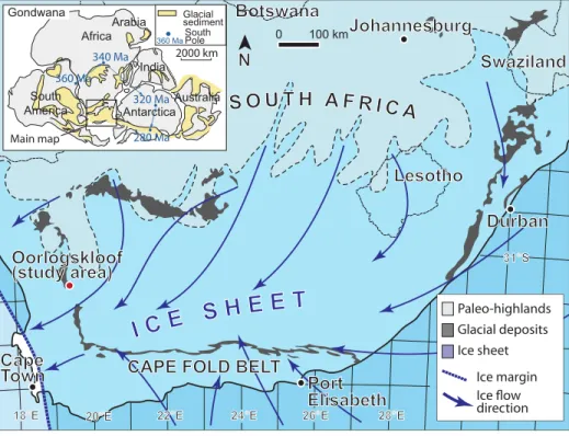
and 1990s (Visser, 1983, 1987, 1989, 1990, 1997; Visser and Kingsley, 1982). New insights from satellite image interpretation (Le Heron, 2018; Andrews et al., 2019) together with a new wave of field work on LPIA strata (Vor-ster et al., 2016; Linol et al., 2016; Belica et al., 2017; Griffis et al., 2018; Dietrich and Hofmann, 2019) have sharpened the need to understand the subglacial unconformities, and the role of ice streaming and surging behaviors. In this study, we produced the first detailed map of a LPIA glacial unconformity from Oorlogskloof, North-ern Cape Province, South Africa (Fig. 1), inte-grating data from an unmanned aerial vehicle (UAV) and field observations.
STUDY AREA AND GEOLOGIC BACKGROUND
The Oorlogskloof area lies at the present-day western flank of the Karoo Basin of South Africa (Fig. 1). The late Carboniferous–Perm-ian Dwyka Group was deposited by oscillating, high-latitude ice masses (Visser, 1989), with up to 800-m-thick diamictites and intergla-cial mudstones accumulating during up to four glacial cycles in the basin depocenter (Visser, 1997). At the northeastern flanks, diamictites accumulated in a restricted glacial valley set-ting (Visser and Kingsley, 1982). In the eastern Karoo Basin, a complex, condensed signature
records deglaciation punctuated by short-term stillstands and minor readvances (Dietrich and Hofmann, 2019). Such basin-margin locali-ties record glacially striated pavements of two types: (1) hard-bedrock pavements, recording the direct abrasion of LPIA ice sheets onto hard bedrock material (Du Toit, 1954; Visser and Loock, 1988; Bussert, 2010), and (2) soft-sediment pavements (e.g., Visser, 1990). The lat-ter pavements, on which we focus herein, were first described in Oorlogskloof and surrounding area by Rust (1963).
Precisely how the sub-Dwyka unconformity was cut remains unclear. Highly complex ice flows, including trunk glaciers, ice streams, and outlet glaciers (e.g., Visser and Kingsley, 1982; Visser, 1997), have been interpreted. Deep paleo-valleys, some up to 160 km long, record differing depths of incision into underlying sedimentary rocks and basement granite and gneiss (Visser and Kingsley, 1982). Across the Karoo, glaciers are thought to have coalesced from ice centers ini-tially located to the north, east, and south (Visser, 1987, 1989). Crucially, ice-margin disintegration models are strongly influenced by interpretation of the Oorlogskloof pavement in which a phase of ice-margin liftoff culminated in collapse and proglacial sedimentation (Visser, 1990).
METHODOLOGY
Combining traditional field work (photo-graphs, descriptions, measurements) with UAV imagery, we mapped the unconformity beneath the Dwyka Formation in Oorlogskloof (Fig. 1) to document its geomorphology. Using a DJI Mavic Pro drone, high-resolution aerial pho-tographs were obtained from multiple eleva-tions (8–100 m) and stitched together in Agi-soft Metashape Agi-software (www.agiAgi-soft.com). A digital elevation model (DEM) together with a mosaicked orthophoto were exported to QGIS
(www.qgis.com). Applying the methodology of Le Heron et al. (2019), a transparency algorithm was applied to the latter, allowing the two im-ages to be combined and producing a composite
aerial image. The resultant image, which served as the foundation for mapping (Fig. 2), enhances geological features that may be present on the orthophoto and absent on the DEM.
RESULTS Description
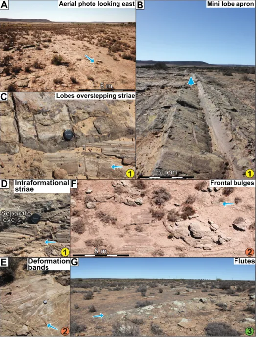
The study section consists of medium- to coarse-grained sandstone and pebbly sand-stone of the Silurian- to Devonian-aged Nar-douw Subgroup (Table Mountain Group, Cape Supergroup; Thamm and Johnson, 2006), onto which series of glacially related landforms tied to the LPIA were cut. The surface dips gently east at 4°. Analysis of the composite aerial im-age (Fig. 2) demonstrated that the glacial land-forms are spatially organized into three distinct packages (Figs. 3 and 4), and that these packages show crosscutting relationships.
Package 1 exposes two distinct sets of streamlined features, namely (1) flutes, and (2) grooves and striae. Both sets of features trend east-west to ESE-WNW (270 to N285; Fig. 3; see also Visser, 1990, his figure 6). Flutes are sharp-crested, 5–20-cm-amplitude, and 50-cm-wide features. Asymmetric in transverse profile, they exhibit steep (25°–40°) northward sides and less steeply dipping (10°–25°) southward sides. Miniature grain-flow lobes occur on southward slopes, downlapping the troughs between the flutes (Fig. 3B). Striations also occur on the surfaces of the flutes (Fig. 3B). Flutes are distributed into sets of one to five that lie on a planar striated and grooved surface also characterized by smaller-scale (a few mil-limeters to centimeters in amplitude) flutes. The flute sets, separated by the striated and grooved surface devoid of large flutes, thus define a
lin-0 100 km
Botswana
NamibiaSwaziland
N
S O U T H A F R I C A
I C E
S H E E T
360 Ma 340 Ma 320 Ma 280 Ma South America Africa Arabia Antarctica Australia India Glacial sediment 360 MaSouthPole 2000 kmCape
Town
Oorlogskloof
(study area)
Johannesburg
Durban
Port
Elisabeth
Paleo-highlands Glacial deposits Ice sheet Ice margin directionLesotho
CAPE FOLD BELT
Main map 31°S 26°E 28°E 24°E 22°E 18°E 20°E GondwanaFigure 1. Paleogeographic map of South Africa during the late Paleozoic ice age, and outline of ice-sheet flow character, based on Visser (1997) and Lopez-Gamundi and Buatois (2010). Study area at Oorlogskloof is situated at the western margin of the Karoo Basin.
1 2 323690 323710 323730 323750 323770 323790 6520410 652043 0 Cross cutting relationships: Ice flow 1 2 3 Faults B C D E F G 6 m Package 3 Package 2 Package 1 3 N Figure 2. Composite aerial image and corre-sponding interpretation of Oorlogskloof glacial pavement (South Africa). Colors correspond to three different packages of subglacial bed form, which can be distin-guished on the basis of slightly differing orien-tations at crosscutting relationships. Color-cod-ing also corresponds to Figures 3 and 4. Locations of photos B–G shown in Figure 3 are indicated.
eation pattern at a larger wavelength (1–3 m). Intraformational striations also occur, which are defined as those that occur beneath the present-day land surface at multiple stratigraphic levels (Fig. 3D).
Package 2 (Fig. 2) is notable for frontal bulg-es (Fig. 3F), which are arcuate pilbulg-es of sand-stone in which the margins deflect, contort, and warp the striae and flutes of package 1 (Fig. 2). A dispersion tail is sometimes observed in the
downstream continuation of some of the frontal bulges. Conjugate deformation bands (Fossen et al., 2007) surround the bulges (Fig. 3E).
Package 3 consists of large-scale flutes up to 10 m long, one of which has a well-defined eastern apex. The amplitude of these streamlined features is meter scale. The southern margin of package 3 crosscuts packages 1 and 2 oblique-ly (Fig. 2). While flutes, grooves, and frontal bulges generally trend east-west in each of the
packages, those in package 3 are somewhat sinu-ous (Fig. 3G).
Interpretation
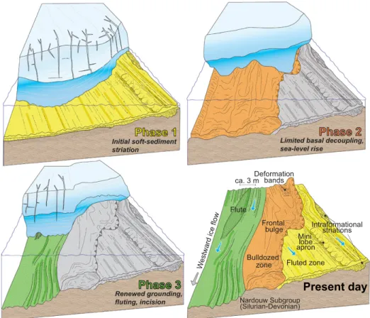
Unlike many other subglacial unconformi-ties of the Karoo Basin, which typically occur as hard bedrock scratches onto crystalline base-ment beneath the Dwyka Formation (Visser and Loock, 1988), all deformation in the Oorlog-skloof locality is well established to be soft sediment in nature, as evidenced by fluting and bulging (see also Visser, 1990), either as sub-glacial material emplaced during the formation of the subglacial features or, alternatively, as reworking of the still unlithified underlying Nardouw Subgroup. The preservation of the Oorlogskloof assemblage was previously ar-gued to result from “separation of the glacier sole from the substrate during a sudden rise in sea-level” (Visser, 1990, p. 231). Based on crosscutting relationships, we argue that this complexity is attributable to a lateral shift in the locus of erosion in the subglacial environment (Fig. 4). The three laterally superposed bed-form packages record subglacial incision and fluting (package 1), temporary separation of the basal ice from its bed (package 2), and renewed coupling and fluting (package 3; Fig. 4). The frontal bulge deformation structures in pack-age 2 are comparable to terminal berms at the leading edge of iceberg keel scour marks (e.g., Wood worth-Lynas and Dowdeswell, 1994; Vesely and Assine, 2014) and provide affirmative evidence of ice advance to the west. Nevertheless, we attribute these structures to temporary liftoff of the ice margin from the sediment surface to explain the third, crosscut-ting set of structures (package 3). The presence of conjugate deformation bands testifies to the application of a vertical load, compacting and distorting the sediment.
The soft-sediment striated surface was largely generated at the ice-sediment interface, with some evidence for intrasediment shearing and soft-sedi-ment striation (Sutcliffe et al., 2000; Deynoux and Ghienne, 2004; Le Heron et al., 2005; Trosdtorf et al., 2005). The steepness of the flutes exceeded the angle of repose, and during local decoupling of the ice from its bed, grain-flow lobes were shed into the adjacent grooves. The asymmetric profiles of the flutes, in tandem with the development of mini-grain-flow lobes down one side only, are also compatible with the progressive lateral shift in the locus of subglacial erosion toward the north of the study site as the striated surface evolved. At modern ice grounding lines in Antarctica, tidal activity results in periodic liftoff of the ice margin from the seafloor during the rising tide, which then touches back down on the bed as the tide re-cedes (Domack and Harris, 1998; Domack et al., 1999). Thus, we appeal to a dynamic, buoyant ice margin to explain the present-day arrangement of structures (Fig. 4).
A
Aerial photo looking eastLobes overstepping striae
Mini lobe apron
1
1
Intraformational striae Deformation bands3
Flutes2
2
C
E
F
G
B
D
1
Separate 5 m 5 m 30 cm levels Frontal bulgesFigure 3. Photographs of Oorlogskloof glacial pavement (South Africa), with interpreted direc-tion of ice advance shown by the blue arrow in each case. Text is color-coded to correspond to three discrete landform packages (numbers in colored circles) mapped in Figure 2. (A) General overview provided by an oblique aerial photograph looking westward. (B) Close-up image of the minilobe apron developed on landform package 1. (C) Detail of minilobes overstepping/ downlapping onto striae in package 1. (D) Evidence for intraformational striated surfaces in package 1. (E) Centimeter-scale deformation bands (normal faults with millimeter- to centi-meter-scale throws interpreted to form through compaction of unlithified sand) in package 2. (F) Development of frontal bulges in package 2, deflecting and warping the landforms in package 1. (G) Example of well-defined isolated flute in package 3. Note that locations of all features shown in photos B–G are shown in Figure 2.
DISCUSSION AND CONCLUSION
Outcrop-scale analysis of the Oorlogskloof surface revealed that (1) the locus of erosion shifted laterally in the subglacial environment, (2) crosscutting relationships reveal that the un-conformity is much more complex than previ-ously thought, and (3) these relationships can be explained though basal liftoff and regrounding. Collectively, this analysis provides significant new insight into the degree of coupling between the Dwyka ice mass and its bed, challenging earlier views of a simple retreat and progres-sive basal liftoff prior to deposition of subaque-ous diamictites (Visser, 1990), because renewed grounding is required to explain the youngest suite of structures. We speculate that this would have been best accomplished by cyclic, poten-tially tidally influenced grounding in a marginal marine setting. We emphasize that the entire as-semblage in Oorlogskloof can be interpreted as an evolving subglacial setting during a single advance-retreat cycle.
Previous planform models envisaged a large ice sheet feeding trunk ice streams that flowed westward to South America (Visser, 1989, 1997). The assemblage of structures de-scribed herein is closely comparable to those described from the Late Ordovician of North
Africa, which are typically associated with pa-leo–ice stream tracks (Moreau et al., 2005). Interestingly, structures of different orders of magnitude appear to be geometrically identical and thus self-similar (cf. Deynoux and Ghi-enne, 2004; Trotsdorf et al., 2005; Le Heron, 2018). In southern Africa, LPIA subglacial structures are also well developed on hard-bedrock substrates, particularly on the eastern flank of the Karoo Basin, together with puta-tive megascale glacial lineations interpreted to result from paleo–ice stream tracks in northern Namibia (Andrews et al., 2019). The spatial relationships between hard-bedrock and soft-sediment striated pavements remain poorly established, although it is speculated that the former are “basin marginal,” whereas the latter are “intrabasinal” in terms of paleogeographic significance. Collectively, detailed analysis of these unconformities has much to reveal about the styles and mechanisms of LPIA ice flow across the Karoo Basin and neighboring areas. Tools such as detrital zircon analysis (Crad-dock et al., 2019) allow sediment transport distances of up to thousands of kilometers to be posited for the Dwyka diamictites, but map-ping and unconformity analysis are essential to reveal ice dynamics in detail.
Reevaluation of glacial unconformities from an aerial perspective is one step toward revealing the “missing link” between full glacial and deglacial conditions in deep time. This is because the laterally superposed sets of struc-tures, charting the evolution of the subglacial environment, preserve vital information. Often, this information is missing, e.g., where trans-gressive deposits blanket glacial deposits, with extensive reworking suspected. However, re-evaluation of comparable subglacial unconfor-mities in other basins where a similar range of structures is recognized (e.g., the Sarah Forma-tion of Saudi Arabia; Tofaif et al., 2019) may reveal critical steps in the evolving subglacial environment during retreat that have been hith-erto overlooked. Reappraisal of similar surfac-es of different agsurfac-es with the approach adopted herein may help crack long-standing enigmas, such as whether they developed subglacially or through the grounding of drifting icebergs (Dowdeswell et al., 2016).
ACKNOWLEDGMENTS
Le Heron, Dietrich, and Busfield are extremely grate-ful for the warm hospitality of Chris and Nan at Swiss Villa, Nieuwoudtville, during their field-work stay. Both Le Heron and Dietrich are grateful to the South Africa–Austria joint project of the National Research Foundation (NRF) and the Österreichischer Austaus-chdienst (OEAD Project no. ZA 08/2019) for funding.
REFERENCES CITED
Andrews, G.D., McGrady, A.T., Brown, S.R., and Maynard, S.M., 2019, First description of sub-glacial megalineations from the late Paleozoic ice age in southern Africa: PLoS One, v. 14, p. e0210673, https://doi .org/10.1371/journal. pone.0210673.
Assine, M.L., de Santa Ana, H., Veroslavsky, G., and Vesely, F.F., 2018, Exhumed subglacial landscape in Uruguay: Erosional landforms, depositional environments, and paleo–ice flow in the context of the late Paleozoic Gondwanan glaciation: Sedimentary Geology, v. 369, p. 1–12, https:// doi .org/10.1016/ j.sedgeo.2018.03.011. Belica, M.E., Tohver, E., Poyatos-More, M., Flint,
S., Parra-Avila, L.A., Lanci, L., Denyszyn, S., and Pisarevsky, S.A., 2017, Refining the chro-nostratigraphy of the Karoo Basin, South Africa: Magnetostratigraphic constraints support an Ear-ly Permian age for the Ecca Group: Geophysi-cal Journal International, v. 211, p. 1354–1374, https://doi .org/10.1093/gji/ggx344.
Bussert, R., 2010, Exhumed erosional landforms of the late Palaeozoic glaciation in northern Ethiopia: Indicators of ice-flow direction, palaeolandscape and regional ice dynamics: Gondwana Research, v. 18, p. 356–369, https://doi .org/10.1016/ j.gr.2009.10.009.
Craddock, J.P., et al., 2019, Detrital zircon prove-nance of Permo-Carboniferous glacial diamic-tites across Gondwana: Earth-Science Reviews, v. 192, p. 285–316, https://doi .org/10.1016/ j.earscirev.2019.01.014.
Davies, N.J., and Shillito, A.P., 2018, Incomplete but intricately detailed: The inevitable preservation of true substrates in a time-deficient stratigraphic record: Geology, v. 46, p. 679–682, https://doi .org/10.1130/G45206.1.
ca. 3 m
Present day
Initial soft-sediment
striation Limited basal decoupling,sea-level rise
Phase 1
Phase 2
Renewed grounding, fluting, incisionPhase 3
Fluted zone Nardouw Subgroup (Silurian-Devonian) Intraformational striationsWestward ice flow
Flute Bulldozed zone Frontal bulge Deformation bands Mini lobe apron
Figure 4. Series of schematic models showing the progressive development of each land-form package on the Oorlogskloof (South Africa) surface. Each landland-form package is allied to a corresponding phase of incision, as the locus of incision migrated from right to left on the diagram (toward the north in Fig. 2). Colors correspond to three landform packages in Figure 2. The final result, with three crosscutting landform packages produced through subglacial shearing and fluting separated by a buoyancy phase (phase 2), is shown in present-day situation.
Denis, M., Guiraud, M., Konaté, M., and Buoncristiani, J.F., 2010, Subglacial deformation and water-pres-sure cycles as a key for understanding ice stream dynamics: Evidence from the Late Ordovician succession of the Djado Basin (Niger): Interna-tional Journal of Earth Sciences, v. 99, p. 1399– 1425, https://doi .org/10.1007/s00531-009-0455-z. Deynoux, M., and Ghienne, J.F., 2004, Late Ordovi-cian glacial pavements revisited: A reappraisal of the origin of striated surfaces: Terra Nova, v. 16, p. 95–101, https://doi .org/10.1111/ j.1365-3121.2004.00536.x.
Dietrich, P., and Hofmann, A., 2019, Ice-margin fluc-tuation sequences and grounding zone wedges: The record of the late Paleozoic ice age in the eastern Karoo Basin (Dwyka Group, South Af-rica): The Depositional Record, v. 5, p. 247–271, https://doi .org/10.1002/dep2.74 .
Domack, E., and Harris, P.T., 1998, A new deposi-tional model for ice shelves, based upon sedi-ment cores from the Ross Sea and the MacRob-ertson shelf, Antarctica: Annals of Glaciology, v. 27, p. 281–284, https://doi .org/10.3189/1998 AoG27-1-281-284.
Domack, E.W., Jacobson, E.A., Shipp, S.S., and An-derson, J.B., 1999, Late Pleistocene–Holocene retreat of the West Antarctic Ice Sheet system in the Ross Sea: Part 2—Sedimentologic and stratigraphic signature: Geological Society of America Bulletin, v. 111, p. 1517–1536, https:// doi .org/10.1130/0016-7606(1999)111<1517:LP HROT>2.3.CO;2.
Dowdeswell, J.A., Canals, M., Jakobsson, M., Todd, B.J., Dowdeswell, E.K., and Hogan, K.A., eds., 2016, Atlas of Submarine Glacial Landforms: Modern, Quaternary and Ancient: Geological Society [London] Memoir 46, 618 p., http://doi .org/10.1144/M46.
Du Toit, A.L., 1921, The Carboniferous glaciation of South Africa: Transactions of the Geological So-ciety of South Africa, v. 24, p. 188–227. Du Toit, A.L., 1954, Geology of South Africa: London,
Oliver & Boyd, 611 p.
Fossen, H., Schult, R.A., Shipton, Z.K., and Mair, K., 2007, Deformation bands in sandstone: A review: Journal of the Geological Society [London], v. 164, p. 755–769, https://doi .org/10.1144/0016-76492006-036.
Ghienne, J.-F., Le Heron, D.P., Moreau, J., and Dey-noux, M., 2007, The Late Ordovician glacial sedi-mentary system of the West Gondwana platform, in Hambrey, M.J., et al., eds., Glacial Sedimen-tary Processes and Products: International Asso-ciation of Sedimentologists Special Publications, v. 39, p. 295–319.
Girard, F., Ghienne, J.-F., Du-Bernhard, X., and Ru-bino, J.-L., 2015, Sedimentary imprints of former ice-sheet margins: Insights from an end-Ordovi-cian archive (SW Libya): Earth-Science Reviews, v. 148, p. 259–289, https://doi .org/10.1016/ j.earscirev.2015.06.006.
Griffis, N.P., et al., 2018, Isotopes to ice: Constraining provenance of glacial deposits and ice centers in
west-central Gondwana: Palaeogeography, Pal-aeoclimatology, Palaeoecology, v. 531, 108745, https://doi .org/10.1016/ j.palaeo.2018.04.020. Le Heron, D.P., 2018, An exhumed Paleozoic glacial
landscape in Chad: Geology, v. 46, p. 91–94, https://doi .org/10.1130/G39510.1.
Le Heron, D.P., Sutcliffe, O.E., Whittington, R.J., and Craig, J., 2005, The origins of glacially related soft-sediment deformation structures in Upper Ordovician glaciogenic rocks: Implication for ice-sheet dynamics: Palaeogeography, Palaeo-climatology, Palaeoecology, v. 218, p. 75–103, https://doi .org/10.1016/ j.palaeo.2004.12.007. Le Heron, D.P., Vandyk, T.M., Hongwei, K., Liu, Y.,
Chen, X., Wang, Y., Yang, Z., Scharfenberg, L., Davies, B., and Shields, G., 2019, A bird’s-eye view of an Ediacaran glacial landscape: Geol-ogy, v. 47, p. 705–709, https://doi .org/10.1130/ G46285.1.
Linol, B., de Wit, M.J., Barton, E., de Wit, M.J.C., and Guillocheau, F., 2016, U-Pb detrital zircon dates and source provenance analysis of Phanerozoic sequences of the Congo Basin, central Gond-wana: Gondwana Research, v. 29, p. 208–219, https://doi .org/10.1016/ j.gr.2014.11.009. Lopez-Gamundi, O., and Buatois, L.A., 2010,
In-troduction: Late Paleozoic glacial events and postglacial transgressions in Gondwana, in Lo-pez-Gamundi, O., and Buatois, L.A., eds., Late Paleozoic Glacial Events and Postglacial Trans-gressions in Gondwana: Geological Society of America Special Paper 468, p. v–viii, https://doi .org/10.1130/2010.2468(00).
Moreau, J., Ghienne, J.-F., Le Heron, D.P., Deynoux, M., and Rubino, J.-L., 2005, A 440 million year old ice stream in North Africa: Geology, v. 33, p. 753–756, https://doi .org/10.1130/G21782.1. Rust, I.C., 1963, Note on a glacial pavement near
Nieuwoudtville: South African Journal of Sci-ence, v. 59, p. 12.
Sutcliffe, O.E., Dowdeswell, J.A., Whittington, R.J., Theron, J.N., and Craig, J., 2000, Calibrating the Late Ordovician glaciation and mass ex-tinction by the eccentricity cycles of the Earth’s orbit: Geology, v. 23, p. 967– 970, https://doi .org/10.1130/0091-7613(2000)28<967:CTLOG A>2.0.CO;2.
Thamm, A.G., and Johnson, M.R., 2006, The Cape Supergroup, in Johnson, M.R., Anhaeusser, C.R., and Thomas, R.J., eds., The Geology of South Africa: Johannesburg, South Africa, Geological Society of South Africa, and Pretoria, South Af-rica, Council for Geosciences, p. 443–460. Tofaif, S., Le Heron, D.P., and Melvin, J., 2019,
Devel-opment of a palaeovalley complex on a Late Ordo-vician glaciated margin in NW Saudi Arabia, in Le Heron, D.P., et al., eds., Glaciated Margins: The Sedimentary and Geophysical Archive: Geologi-cal Society, London, Special Publications, v. 475, p. 81–107, https://doi .org/10.1144/SP475.8. Trosdtorf, I., Rocha-Campos, A.C., dos Santos, P.R.,
and Tomio, A., 2005, Origin of late Paleozoic, multiple, glacially striated surfaces in northern
Paraná Basin (Brazil): Some implications for the dynamics of the Paraná glacial lobe: Sedi-mentary Geology, v. 181, p. 59–71, https://doi .org/10.1016/ j.sedgeo.2005.07.006.
Vesely, F.F., and Assine, M.L., 2014, Ice-keel scour marks in the geological record: Evidence from Carboniferous soft-sediment striated surfaces in the Paraná Basin, southern Brazil: Journal of Sedimentary Research, v. 84, p. 26–39, https:// doi .org/10.2110/jsr.2014.4.
Visser, J.N.J., 1983, An analysis of the Permo-Carbon-iferous glaciation in the marine Kalahari Basin, southern Africa: Palaeogeography, Palaeoclima-tology, Palaeoecology, v. 44, p. 295–315, https:// doi .org/10.1016/0031-0182(83)90108-6. Visser, J.N.J., 1987, The palaeogeography of part of
southwestern Gondwana during the Permo-Car-boniferous glaciation: Palaeogeography, Palaeo-climatology, Palaeoecology, v. 61, p. 205–219, https://doi .org/10.1016/0031-0182(87)90050-2. Visser, J.N.J., 1989, The Permo-Carboniferous Dwyka
Formation of southern Africa: Deposition by a predominantly subpolar marine ice sheet: Palaeo-geography, Palaeoclimatology, Palaeoecology, v. 70, p. 77–391.
Visser, J.N.J., 1990, Glacial bedforms at the base of the Permo-Carboniferous Dwyka Formation along the western margin of the Karoo Basin, South Africa: Sedimentology, v. 44, p. 507–521, https:// doi .org/10.1111/ j.1365-3091.1990.tb00957.x. Visser, J.N.J., 1997, Deglaciation sequences in the
Permo-Carboniferous Karoo and Kalahari ba-sins of southern Africa: A tool in the analysis of cyclic glaciomarine basin fills: Sedimentology, v. 44, p. 507–521, https://doi .org/10.1046/ j.1365-3091.1997.d01-35.x.
Visser, J.N.J., and Kingsley, C.S., 1982, Upper Car-boniferous glacial valley sedimentation in the Karoo Basin, Orange Free State: Transactions of the Geological Society of South Africa, v. 85, p. 71–79.
Visser, J.N.J., and Loock, J.C., 1988, Sedimentary facies of the Dwyka Formation associated with the Nooitgedacht glacial pavements, Barkly West District: South African Journal of Geology, v. 91, p. 38–48.
Vorster, C., Kramers, J., Beukes, N., and Van Niekerk, H., 2016, Detrital zircon U-Pb ages of the Pal-aeozoic Natal Group and Msikaba Formation, Kwazulu-Natal, South Africa: Provenance areas in the context of Gondwana: Geological Maga-zine, v. 153, p. 460–486, https://doi .org/10.1017/ S0016756815000370.
Woodworth-Lynas, C.M.T., and Dowdeswell, J.D., 1994, Soft-sediment striated surfaces and mas-sive diamicton facies produced by floating ice, in Deynoux, M., et al., eds., Earth’s Glacial Record: Cambridge, UK, Cambridge Univer-sity Press, p. 241–259, https://doi .org/10.1017/ CBO9780511628900.019.