HAL Id: hal-01670642
https://hal.archives-ouvertes.fr/hal-01670642
Submitted on 21 Dec 2017
HAL is a multi-disciplinary open access
archive for the deposit and dissemination of
sci-entific research documents, whether they are
pub-lished or not. The documents may come from
teaching and research institutions in France or
abroad, or from public or private research centers.
L’archive ouverte pluridisciplinaire HAL, est
destinée au dépôt et à la diffusion de documents
scientifiques de niveau recherche, publiés ou non,
émanant des établissements d’enseignement et de
recherche français ou étrangers, des laboratoires
publics ou privés.
International Ocean Discovery Program Expedition 363
Preliminary Report Western Pacific Warm Pool
Neogene and Quaternary records of Western Pacific
Warm Pool paleoceanography
Yair Rosenthal, Ann Holbourn, Denise Kulhanek, Ivano Aiello, Tali Babila,
Germain Bayon, Luc Beaufort, Samantha Bova, Jong-Hwa Chun, Haowen
Dang, et al.
To cite this version:
Yair Rosenthal, Ann Holbourn, Denise Kulhanek, Ivano Aiello, Tali Babila, et al.. International Ocean
Discovery Program Expedition 363 Preliminary Report Western Pacific Warm Pool Neogene and
Qua-ternary records of Western Pacific Warm Pool paleoceanography. 2017, �10.14379/iodp.pr.363.2017�.
�hal-01670642�
International Ocean Discovery Program
Expedition 363 Preliminary Report
Western Pacific Warm Pool
Neogene and Quaternary records of Western Pacific Warm
Pool paleoceanography
6 October–8 December 2016
February 2017
Core samples and the wider set of data from the science program covered in this report are under moratorium and accessible only to Science Party members until 8 June 2018.
This publication was prepared by the JOIDES Resolution Science Operator (JRSO) at Texas A&M University (TAMU) as an account of work performed under the International Ocean Discovery Pro-gram (IODP). Funding for IODP is provided by the following international partners:
National Science Foundation (NSF), United States
Ministry of Education, Culture, Sports, Science and Technology (MEXT), Japan European Consortium for Ocean Research Drilling (ECORD)
Ministry of Science and Technology (MOST), People’s Republic of China Korea Institute of Geoscience and Mineral Resources (KIGAM)
Australia-New Zealand IODP Consortium (ANZIC) Ministry of Earth Sciences (MoES), India
Coordination for Improvement of Higher Education Personnel (CAPES), Brazil
Portions of this work may have been published in whole or in part in other International Ocean Discovery Program documents or publications.
Disclaimer
Any opinions, findings, and conclusions or recommendations expressed in this publication are those of the author(s) and do not necessarily reflect the views of the participating agencies, TAMU, or Texas A&M Research Foundation.
Copyright
Except where otherwise noted, this work is licensed under a Creative Commons Attribution
License (http://creativecommons.org/licenses/by/4.0/deed.en_US). Unrestricted use, distribution,
and reproduction are permitted, provided the original author and source are credited.
Citation
Rosenthal, Y., Holbourn, A.E., Kulhanek, D.K., and the Expedition 363 Scientists, 2017. Expedition 363 Preliminary
Report: Western Pacific Warm Pool. International Ocean Discovery Program.
http://dx.doi.org/10.14379/iodp.pr.363.2017
ISSN
Expedition 363 participants
Expedition 363 scientists
Yair Rosenthal Co-Chief Scientist
Department of Marine and Coastal Services Rutgers, The State University of New Jersey 71 Dudley Road New Brunswick NJ 08901-8521 USA rosentha@marine.rutgers.edu Ann E. Holbourn Co-Chief Scientist Institute of Geosciences Christian-Albrechts-Universität zu Kiel Ludewig-Meysnstrasse 14 Kiel 24118 Germany ah@gpi.uni-kiel.de Denise K. Kulhanek
Expedition Project Manager/Staff Scientist International Ocean Discovery Program Texas A&M University
1000 Discovery Drive College Station TX 77845 USA kulhanek@iodp.tamu.edu Ivano W. Aiello Sedimentologist Geological Oceanography
Moss Landing Marine Laboratories 8272 Moss Landing Road
Moss Landing CA 95039-9647 USA
iaiello@mlml.calstate.edu
Tali L. Babila
Inorganic Geochemist
Department of Earth and Planetary Sciences University of California, Santa Cruz 1156 High Street Santa Cruz CA 95064 USA tbabila@ucsc.edu Germain Bayon Inorganic Geochemist
Unité Géosciences Marines
Institut Francaise de Recherche pour l’Exploitation de la Mer (IFREMER) Plouzané 29280 France gbayon@ifremer.fr Luc Beaufort Paleontologist (nannofossils)
Centre Europén de Recherche et d’Enseignement de Géologie de l’Environnement (CEREGE)
Centre National de la Recherche Scientifique (CNRS) Aix-Marseille Université Aix en Provence 13545 France beaufort@cerege.fr Samantha C. Bova Sedimentologist
Department of Marine and Coastal Services Rutgers, The State University of New Jersey 71 Dudley Road New Brunswick NJ 08901-8521 USA samantha.bova@rutgers.edu Jong-Hwa Chun Sedimentologist
Petroleum and Marine Research Division
Korea Institute of Geoscience and Mineral Resources (KIGAM) 124 Gwahnag-no, Yuseong-fu Daejeon 305-350 Korea jhchun@kigam.re.kr Haowen Dang Sedimentologist
State Key Laboratory of Marine Geology Tongji University
1239 Siping Road Shanghai 200092 P.R. China
hwdang@gmail.com
Anna Joy Drury
Physical Properties Specialist
MARUM–Center for Marine Environmental Sciences University of Bremen
Leobener Strasse Bremen 28359 Germany
ajdrury@marum.de
Tom Dunkley Jones
Paleontologist (nannofossils)
School of Geography, Earth and Environmental Sciences University of Birmingham
Edgbaston
Birmingham B15 2TT United Kingdom
Patrícia P.B. Eichler
Paleontologist (benthic foraminifers)
Department of Geophysics, Geodynamics and Geology Federal University of Rio Grande do Norte
Campus Universitário, Lagoa Nova Natal RN 59078-970
Brazil
patriciaeichler@gmail.com
Allan G. Salazar Fernando
Observer/Paleontologist (nannofossils) National Institute of Geological Sciences University of the Philippines, Diliman Quezon City 1101 Philippines agsfernando@yahoo.com asfernando@up.edu.ph Kelly Gibson Inorganic Geochemist
School of Earth, Ocean, and Environment University of South Carolina
701 Sumter Street Columbia SC 29208 USA kgibson@geol.sc.edu Robert G. Hatfield Paleomagnetist
College of Earth, Ocean and Atmospheric Sciences Oregon State University
104 CEOAS Admin. Building Corvallis OR 97331
USA
rhatfiel@coas.oregonstate.edu
Daniel L. Johnson Inorganic Geochemist
Department of Geological and Planetary Sciences California Institute of Technology
1200 E. California Boulevard Pasadena CA 91125 USA d.johnson@caltech.edu Yuho Kumagai Paleomagnetist
Department of Earth Science Tohoku University Aoba 6-3 Sendai 980-8578 Japan yuho.kumagai.q4@dc.tohoku.ac.jp Tiegang Li Paleontologist (foraminifers)
Key Laboratory of Marine Geology and Environment Institute of Oceanology, Chinese Academy of Sciences 7 Nanhai Road Qingdao Shandong 266071 P.R. China tgli@qdio.ac.cn Braddock K. Linsley Sedimentologist
Lamont-Doherty Earth Observatory Columbia University 104E Geosciences 61 Route 9W Palisades NY 10964 USA blinsley@ldeo.columbia.edu Niklas Meinicke Sedimentologist
Department of Earth Science University of Bergen, Norway Allegaten 41
Bergen 5007 Norway
niklas.meinicke@uib.no
Gregory S. Mountain
Stratigraphic Correlator/Downhole Measurements Department of Earth and Planetary Sciences Rutgers, The State University of New Jersey 610 Taylor Road Piscataway NJ 08854-8066 USA gmtn@rci.rutgers.edu Bradley N. Opdyke Sedimentologist
Research School of Earth Sciences Australian National University Canberra ACT 0200
Australia
bradley.opdyke@anu.edu.au
Paul N. Pearson
Paleontologist (foraminifers) School of Earth and Ocean Sciences Cardiff University
Main Building, Park Place Cardiff CF10 3AT United Kingdom
pearsonp@cardiff.ac.uk
Christopher R. Poole Paleontologist (foraminifers)
Department of Earth Sciences University College London Gower Street London WC1E 6BT United Kingdom christopher.poole@ucl.ac.uk Christina Ravelo Stratigraphic Correlator
Ocean Sciences Department University of California, Santa Cruz 1156 High Street
Santa Cruz CA 95064 USA
Takuya Sagawa Sedimentologist
Institute of Science and Engineering Kanazawa University Kakuma-machi Kanazawa 920-1192 Japan tsagawa@staff.kanazawa-u.ac.jp Anaïs Schmitt
Physical Properties Specialist/Downhole Measurements Faculty of Science and Technology
Université de Nantes 2 rue de la Houssinière Nantes 44322 France anais.schmitt@univ-nantes.fr Jennifer B. Wurtzel
Physical Properties Specialist Research School of Earth Sciences Building 142, Mills Road
Australian National University Canberra ACT 0200
Australia
jennifer.wurtzel@anu.edu.au
Jian Xu
Physical Properties Specialist Department of Geology Northwest University 229 North Taibai Road Xi’an Shaanxi 710069 P.R. China
jx08@live.cn
Masanobu Yamamoto Organic Geochemist
Faculty of Environmental Earth Science Hokkaido University
Kita-10, Nishi-5, Kita-ku Sapporo 060-0810 Japan myama@ees.hokudai.ac.jp Yige Zhang Organic Geochemist Department of Oceanography Texas A&M University MS 3146 TAMU College Station TX 77843 USA
yige.zhang@tamu.edu
Observer
Allan G. Salazar Fernando
Observer/Paleontologist (nannofossils) National Institute of Geological Sciences University of the Philippines, Diliman Quezon City 1101
Philippines
agsfernando@yahoo.com asfernando@up.edu.ph
Education and Outreach
Katie Halder Canning College Marquis Street Bentley WA 6102 Australia katiehalder@gmail.com Stephanie A. Spray FilmmakerDepartment of Critical Media Practices University of Colorado Boulder 1060 18th Street, UCB 315 Boulder CO 80309-0315 USA
SIEM Offshore AS officials
Terry SkinnerMaster of the Drilling Vessel
Steve McLelland
Offshore Installation Manager
Technical support
Alexis Armstrong Core Laboratory Heather Barnes
Assistant Laboratory Officer Chad Broyles
Curatorial Specialist Michael Cannon
Marine Computer Specialist Etienne Claassen
Marine Instrumentation Specialist Ty Cobb
Physical Properties Laboratory William Crawford
Senior Imaging Specialist Douglas Cummings Publications Specialist Benjamin Daniel X-Ray Laboratory Roy Davis Laboratory Officer David Fackler Applications Developer Seth Frank
Thin Section Laboratory
Edwin Garrett Paleomagnetics Laboratory Rachael Gray Core Laboratory Kevin Grigar Operations Superintendent Margaret Hastedt Core Laboratory Jan Jurie Kotze
Marine Instrumentation Specialist Zenon Mateo
Core Laboratory Erik Moortgat Chemistry Laboratory Chieh Peng
Assistant Laboratory Officer Vincent Percuoco
Chemistry Laboratory Kerry Swain
Logging Engineer Steven Thomas
Marine Computer Specialist Hai (James) Zhao
Abstract
International Ocean Discovery Program Expedition 363 sought to document the regional expression and driving mechanisms of cli-mate variability (e.g., temperature, precipitation, and productivity) in the Western Pacific Warm Pool (WPWP) as it relates to the evo-lution of Neogene climate on millennial, orbital, and geological timescales. To achieve our objectives, we selected sites with wide geographical distribution and variable oceanographic and depo-sitional settings. Nine sites were cored during Expedition 363, re-covering a total of 6956 m of sediment in 875–3421 m water depth with an average recovery of 101.3% during 39.6 days of on-site oper-ations. Two sites are located off northwestern Australia at the southern extent of the WPWP and span the late Miocene to pres-ent. Seven sites are situated at the heart of the WPWP, including two sites on the northern margin of Papua New Guinea (PNG) with very high sedimentation rates spanning the past ~450 ky, two sites in the Manus Basin north of PNG with moderate sedimentation rates recovering upper Pliocene to present sequences, and three low sedimentation rate sites on the southern and northern parts of the Eauripik Rise spanning the early Miocene to present. The wide spa-tial distribution of the cores, variable accumulation rates, excep-tional biostratigraphic and paleomagnetic age constraints, and mostly excellent foraminifer preservation will allow us to trace the evolution of the WPWP through the Neogene at different temporal resolutions, meeting the primary objectives of Expedition 363. Spe-cifically, the high sedimentation–rate cores off PNG will allow us to better constrain mechanisms influencing millennial-scale variabil-ity in the WPWP, their links to high-latitude climate variabilvariabil-ity, and implications for temperature and precipitation variations in this re-gion under variable climate conditions. Furthermore, these high ac-cumulation rates offer the opportunity to study climate variability during previous warm periods at a resolution similar to existing studies of the Holocene. With excellent recovery, Expedition 363 sites are suitable for detailed paleoceanographic reconstructions at orbital and suborbital resolution from the middle Miocene to Pleis-tocene, and thus will be used to refine the astronomical tuning, magneto-, isotope, and biostratigraphy of hitherto poorly con-strained intervals within the Neogene timescale (e.g., the late Mio-cene) and to reconstruct the history of the East Asian and Australian monsoon and the Indonesian Throughflow on orbital
and tectonic timescales. Results from high-resolution interstitial
water sampling at selected sites will be used to reconstruct density profiles of the western equatorial Pacific deep water during the Last
Glacial Maximum. Additional geochemical analyses of interstitial
water samples in this tectonically active region will be used to inves-tigate volcanogenic mineral and carbonate weathering and their possible implications for the evolution of Neogene climate.
Introduction
The Western Pacific Warm Pool (WPWP), often defined by the 28°C isotherm, is part of the Indo-Pacific Warm Pool (IPWP), which spans the western waters of the equatorial Pacific and eastern
In-dian Ocean (Figure F1). The region is a major source of heat and
moisture to the atmosphere and a location of deep atmospheric convection and heavy rainfall. Small perturbations in the sea-sur-face temperature (SST) of the WPWP influence the location and strength of convection in the rising limb of the Hadley and Walker cells, affecting planetary-scale atmospheric circulation, atmo-spheric heating, and tropical hydrology (Neale and Slingo, 2003;
Wang and Mehta, 2008). These perturbations may also influence heat uptake and storage in the WPWP thermocline and heat trans-port to the Indian Ocean through the Indonesian Throughflow (ITF). These processes also constitute important feedbacks in the climate system due to their influence on the dynamic ocean-atmo-sphere coupling in the equatorial Pacific, thereby exerting a strong
influence on global temperatures and atmospheric pCO2. Detailed
paleoceanographic records, such as those recovered during Expedi-tion 363, offer the opportunity to study the behavior of the WPWP under different mean-state background conditions and its effects on both regional and global climate.
Seasonal to interannual climate variations in the WPWP are dominated by fluctuations in precipitation associated with the sea-sonal march of the monsoons, migration of the Intertropical Con-vergence Zone (ITCZ), and interannual changes associated with variability of the El Niño Southern Oscillation (ENSO) (e.g., Ropelewski and Halpert, 1987; Halpert and Ropelewski, 1992;
Ras-musson and Arkin, 1993) (Figure F2). At present, departures from
expected weather patterns associated with the monsoons and ENSO systems impact the lives of many people in the tropics and many regions around the world. For example, El Niño events are as-sociated with a nearly global fingerprint of temperature and precip-itation anomalies (Ropelewski and Halpert, 1987; Rasmusson and Arkin, 1993; Cane and Clement, 1999). However, considerable un-certainty exists regarding the response of the tropical Pacific cli-mate, primarily precipitation, to rising greenhouse gas concentrations because of our limited understanding of the past variability of the WPWP and conflicting results from data com-pared to models. For example, models simulating the response of the equatorial Pacific to greenhouse gas forcing disagree about whether the zonal temperature gradient will increase or decrease and what the implications will be for the Walker circulation and the hydrologic cycle in the tropics (Forster et al., 2007). These simula-tions typically use an ENSO analogy to predict future climate; in a similar way to interannual ENSO variability, long-term changes in the mean climate state of the equatorial Pacific are often evaluated primarily as changes in the east–west SST gradient. However, re-cent simulations of global warming effects suggest that the tropical Pacific does not become more El Niño- or La Niña-like in response to increased greenhouse gases (DiNezio et al., 2009). Instead, the new simulations suggest a different equilibrium state, whereby shoaling and increased tilt of the equatorial Pacific thermocline is associated with weakening of the trade winds without a concomi-tant change in the zonal SST pattern, which argues against using ENSO as an analog for long-term changes in tropical conditions (DiNezio et al., 2010). In turn, changes in the structure of the ther-mocline can have a major effect on the ocean heat content, and thus global climate, and also on the character of ENSO variability, which has been documented for the Last Glacial Maximum (LGM) (Ford et al., 2015). Changes in thermocline temperature/structure have also been suggested as a possible mechanism responsible for the slowdown in surface warming from ~2000 to 2014 (e.g., England et al., 2014).
A primary goal of this expedition was to assess the regional ex-pression of climate variability (e.g., precipitation, temperature,
pCO2, and biological productivity) within the WPWP in the context
of changes in global background state from the middle Miocene to late Pleistocene. Drill sites were chosen to provide broad spatial coverage to capture the most salient features of the WPWP (Figures
F1, F3) at different temporal resolutions through this time interval (Figure F4). With variable water depths, the sites intersect different
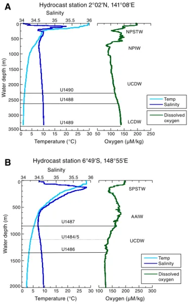
water masses, including the North Pacific Intermediate Water (NPIW), Antarctic Intermediate Water (AAIW), Upper Circumpo-lar Deepwater (UCDW), and Lower CircumpoCircumpo-lar Deepwater
(LCDW) (Figure F5) and thus will allow reconstruction of
interme-diate and deepwater properties at relatively high resolution through time.
Oceanographic settings
The warmest region of the IPWP is the WPWP region east of Indonesia where mean annual SSTs are typically >29°C (Figure F1). As the warmest water body on the planet, the IPWP and in particu-lar the WPWP are known to be influential to the dynamics of ENSO and the Asian-Australian monsoon. Throughout the IPWP, warm water fuels atmospheric convection and heavy rainfall with a net 1– 2 m/y of freshwater input to the ocean. Indeed the biggest seasonal changes in surface hydrography are expressed in salinity with fresh-ening derived by changes in precipitation due to the seasonal march of the ITCZ and the Asian-Australian monsoon. On interannual timescales, ENSO exerts the strongest influence on regional precip-itation and consequently surface salinity. The size of the warm pool also changes seasonally as the core of the WPWP follows the ITCZ migration. As a result, the size of the WPWP is smaller (larger) and SST is cooler north (south) of the Equator during boreal winter (summer) (Figure F2).
The western equatorial Pacific is also a crossroad for thermo-cline and intermediate waters originating at the high latitudes of both hemispheres (Fine, 1994). Because of its complex network of passages and basins, the Indonesian maritime continent on the western edge of the WPWP exerts the strongest control on the communication between the Pacific and Indian Oceans. As part of the global circulation, the ITF is the only equatorial interocean con-nection transferring heat and freshwater from the Pacific to the In-dian Ocean and ultimately to the Atlantic Ocean through the Agulhas Current and thus may have far-reaching effects on climate (Figure F6). The ITF is driven by the average difference in sea level between the Pacific and Indian Oceans (~16 cm). Most of the ITF transport resides in the upper 750 m of the water column, with the maximum volume transport between 150 and 400 m (Fieux et al., 1994; Ffield et al., 2000; Gordon et al., 2003; Susanto and Gordon, 2005). On average, the ITF transports a large amount of water (10–
15 Sv, where 1 Sv = 1,000,000 m3/s) and heat (~0.5 PW, where 1 PW
= 1015 W) from the WPWP north of the Equator to 12°S in the
In-dian Ocean. Approximately 80% of the total ITF moves through the
Makassar Strait (Figure F3). Of this, 25% flows through the Lombok
Strait and 75% flows into the Banda Sea and then into the Indian Ocean through the Timor Strait (Fieux et al., 1994; Gordon and Fine, 1996; Gordon and Susanto, 1999). Water in the upper WPWP thermocline represents a mixture of North Pacific and South Pacific subtropical waters (NPSW and SPSW, respectively). The main ther-mocline, between ~200 and 500 m, receives contributions from the low-salinity, low-oxygen North Pacific Intermediate Water (NPIW;
salinity 34.45; density 26.5–26.8 σθ) advected through the Mindanao
Current and from the New Guinea Coastal Undercurrent (NGCU) transporting oxygen-rich AAIW (salinity ~34.55; density 27.2–27.3 σθ). The deepest sites (>3000 m below sea level [mbsl]) are bathed
by LCDW. The relative contributions of these water masses at each of our drilling sites vary depending on their location.
Motivation for drilling the WPWP
Studies of climate variability in the WPWP have relied primarily on the low sedimentation–rate (~2–3 cm/ky during the Pleistocene) Ocean Drilling Program (ODP) Hole 806B from the Ontong Java Plateau (OJP) (Kroenke, Berger, Janecek, et al., 1991), which serves as a warm end-member to monitor broad-scale zonal and meridio-nal gradients through the Neogene. However, higher resolution sites are currently unavailable from this region, preventing direct comparison with suborbital variability known from high-latitude sites. Over the past decade new coring efforts have demonstrated the possibility of obtaining records from key locations in the WPWP with comparable resolution to records from high-latitude oceans, cave deposits, and ice cores (e.g., Stott et al., 2002; Zuraida et al., 2009). Although substantial progress in understanding WPWP climate variability has been made by studying long piston cores, the newly cored sites of Expedition 363 will address funda-mental questions across a broader spatial distribution and with en-hanced temporal resolution. Expedition 363 cored sites of variable accumulation rates from the following three sectors of the WPWP:
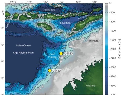
1. The southern sector of the WPWP: Sites U1482 and U1483 are located seaward of the continental slope of northwest Australia at the southwestern edge of the WPWP and along the exit of the ITF to the Indian Ocean. The cores from these sites recovered upper Miocene to recent sediment.
2. The central sector of the WPWP: high accumulation rate Sites U1484 and U1485 on the northern margin of Papua New Guinea close to the Sepik River mouth and Sites U1486 and U1487 in the Manus Basin span the upper Pliocene to recent.
3. The northern sector of the WPWP: cores at Sites U1488 and U1489 at the southern end of the Eauripik Rise and Site U1490 at its northern end recovered low sedimentation–rate sequences spanning the upper Oligocene/lower Miocene to recent. These sites will allow us to address the following research themes.
Investigating millennial-scale climate variability
in the WPWP
The origin of sub-Milankovitch climate variability and its spatial and temporal extent are significantly less understood than mecha-nisms related to orbital climate forcing. Most hypotheses attribute millennial-scale changes during the last glacial interval to either in-stabilities in the Northern Hemisphere ice sheets (e.g., MacAyeal, 1993) or a response to variations in Atlantic Meridional Overturn-ing Circulation (e.g., Rahmstorf, 2002) driven by meltwater inputs to the North Atlantic (e.g., Clark et al., 2001, 2004). Much of the ev-idence for millennial-scale climate variability comes from the North Atlantic and from regions directly affected by that variability. These records suggest a strong link to ice sheet instability primarily during glacial intervals. In low-latitude and tropical regions, millennial-scale variability is mainly expressed as changes in precipitation. Pa-leoprecipitation records suggest a southward shift in the ITCZ posi-tion apparently synchronous with North Atlantic cold events including the Younger Dryas, Heinrich Event 1, and marine isotope Stage (MIS) 3 stadials (Stott et al., 2002, 2004; Oppo et al., 2003;
Dannenmann et al., 2003; Gibbons et al., 2014). These results are
lati-tudes influence the position of the ITCZ (Broccoli et al., 2006; Chi-ang and Bitz, 2005). The global extent and apparent synchroneity of millennial-scale variability have been attributed to fast transmission of climate signals through the atmosphere in response to North At-lantic climate change (Schmittner et al., 2003; Gibbons et al., 2014). However, other studies suggest that orbital insolation changes affect tropical dynamics, possibly related to the response of monsoon and ENSO variability to changes in the mean climate state of the equato-rial Pacific Ocean (Clement et al., 2001; Koutavas et al., 2002, 2006; Stott et al., 2002). Accordingly, changes in the distribution of tropi-cal Pacific SST may have large impacts on global temperatures (Clement et al., 2001; Brown et al., 2015) and low- to mid-latitude heat and moisture transport, which can amplify small radiative per-turbations (Tachikawa et al., 2013).
As a major source of heat and moisture, the WPWP may have played an important role in millennial-scale variability through changes in its spatial extent and/or its SST and consequently on the air-sea heat and moisture exchange. Obtaining long records from the WPWP with comparable resolution to the Greenland ice cores, Chinese speleothems, and high-resolution sediment cores from other regions will provide insight into the mechanisms driving cen-tennial- to millennial-scale climate variability in the context of changes in background climate states.
Reconstructing orbital-scale climate variability
through the Neogene
Significant glacial–interglacial variability characterizes SST re-constructions from the WPWP with the glacial–interglacial tem-perature amplitude increasing from ~2°C in the Pliocene to 3°C in the Pleistocene (de Garidel-Thoron et al., 2005; Medina-Elizalde and Lea, 2005, 2010). These changes are also associated with changes in surface-water δ18O
seawater, suggesting concomitant
hydro-climate changes. Because the tropical Pacific is located far from the polar ice sheets, studies have suggested that the glacial–interglacial variability of tropical Pacific SST is mostly driven by changes in at-mospheric pCO2 (e.g., Lea, 2004; Hansen et al., 2008) and to a lesser extent by changes in local insolation (e.g., Tachikawa et al., 2013). In addition, there may also be strong extratropical controls of WPWP temperatures due to ocean dynamical processes. For example, the presence of significant obliquity variability in SST records from the WPWP throughout the past ~2 My attests to strong linkages with high-latitude climate variability (de Garidel-Thoron et al., 2005) likely transported through the thermocline. The causes and extent of past precipitation changes in the WPWP are not well constrained in terms of the relative importance of changes in boundary condi-tions in the equatorial Pacific compared to the high latitudes, their relationship to equatorial dynamics and the position of the ITCZ, and their associated climate system feedbacks (Figure F2).
Lithologic proxy records of precipitation from the western equatorial Pacific suggest that precession-driven interhemispheric changes in local insolation exert the strongest control on equatorial Pacific hydroclimate, primarily associated with the migration of the ITCZ (Kissel et al., 2010; Tachikawa et al., 2011) and possibly mod-ulated by ENSO-type processes (Dang et al., 2015). Noteworthy is that these precipitation records show no glacial–interglacial cyclic-ity and no clear causal linkage to the climate of the North Atlantic (e.g., Kissel et al., 2010; Tachikawa et al., 2011; Carolin et al., 2013). Instead, recent studies suggest that southward displacement of the ITCZ during deglaciations may have played an important role in the inception of glacial terminations through its influence on the posi-tion of the southwesterly winds as the two wind systems are linked.
A southward shift of the southern westerly jet led to increased
up-welling of CO2-rich deep water around Antarctica, which in turn
enhanced the deglaciation (Denton et al., 2010; Anderson et al., 2009). Modeling studies, supported by new records, confirm the idea of “interhemispheric teleconnection,” whereby warming (cool-ing) of the Northern Hemisphere causes both the ITCZ and the Southern Hemispheric mid-latitude jet to shift northward (south-ward) (Lee et al., 2011; Ayliffe et al., 2013; Ceppi et al., 2013). Inves-tigating these interconnections and their evolution under different background climate states throughout the Neogene is one of the overarching goals of this expedition.
On million-year timescales, the relationships between different equilibrium states of the tropical Pacific and changes in the Equa-tor-to-pole temperature gradient have likely affected ocean circula-tion and thus the global climate evolucircula-tion from the middle Miocene through the late Pleistocene. Specifically, long-term Cenozoic cool-ing was interrupted by periods of relative global warmth durcool-ing the Middle Miocene Climate Optimum (MMCO; ~17–15 Ma) and the early Pliocene warm period (4.5–3 Ma) (Zachos et al., 2001). The period since the MMCO interval is of special interest due to a per-ceived decoupling between global SSTs and variations in atmo-spheric pCO2 (e.g., LaRiviere et al., 2012). The early Pliocene warm
period is of particular interest, as global surface temperatures were ~2°–3°C higher than at present (Dowsett et al., 2009), which is com-parable with projections for the twenty-first century, whereas
atmo-spheric pCO2 was arguably similar to today’s levels (~400 ppm)
(Kürschner et al., 1996; Pagani et al., 2010). Studies suggest that this
period was characterized by a reduced Pacific zonal temperature
gradient due to substantial warming of eastern equatorial Pacific SST (e.g., Wara et al., 2005). However, the spatial extent and magni-tude of SST change in the WPWP and their implications for tropical precipitation are debated (Brierley et al., 2009; Fedorov et al., 2010; Zhang et al., 2014; Ravelo et al., 2014), and new records from this expedition should contribute to this discussion.
The MMCO was also characterized by a warm and humid cli-mate (Mosbrugger et al., 2005; Bruch et al., 2007), with some evi-dence for even weaker meridional temperature gradients (Flower and Kennett, 1994; Bruch et al., 2007; Holbourn et al., 2010) than in the Pliocene, although there are very few data, particularly from the WPWP, to help constrain global temperature gradients. After the MMCO, climate cooled gradually through the late Miocene in many regions but was still warmer than today. It is currently debated whether the WPWP temperature was, on average, similar to today through the late Miocene (Nathan and Leckie, 2009) or significantly warmer (Zhang et al., 2014). The climate mechanisms that explain past warmth during the MMCO, the late Miocene, and the early Pliocene are not yet fully understood, but greenhouse gas forcing and ocean circulation are considered to be important factors.
Re-cent data suggest that pCO2 was higher than today during the
MMCO (Kürschner et al., 2008; Retallack, 2009; Zhang et al., 2013; Greenop et al., 2014) and in the early Pliocene warm period (Pagani et al., 2010; Seki et al., 2010). However, reconstructions suggest pCO2 was relatively low in the late Miocene, similar to levels during the Pleistocene, even though climate was relatively warm and Northern Hemisphere ice sheets were only starting to develop. At
face value, this indicates that for a given pCO2 forcing more than
one climate state (i.e., late Miocene warmth and late Pleistocene
gla-ciation) is possible. Thus, factors other than pCO2, such as ocean
circulation possibly related to tectonic opening or closure of oce-anic gateways (Cane and Molnar, 2001; Steph et al., 2010) or differ-ent modes of deepwater production and circulation (Woodard et
al., 2014), may have played a critical role in determining global cli-mate. In particular, tectonic changes affecting the transport of water from the western Pacific to the Indian Ocean is one mechanism proposed to explain changes in global climate (Cane and Molnar, 2001).
Reconstructing changes in the ITF
through the Neogene
Hydrographic measurements indicate that nearly all of the ITF water in the Makassar Strait derives from the relatively cool NPIW and NPSW (Gordon and Fine, 1996; Gordon and Susanto, 1999). At present, the contribution of denser South Pacific water from the New Guinea Coastal Current to the ITF is limited because of the proximity of West Papua to the Equator (Gordon and Fine, 1996; Hautala et al., 1996; Johnson and McPhaden, 1999; Cane and Mol-nar, 2001). On longer timescales, the strongest controls on the prop-erties and strength of the ITF are likely sea level changes leading to the exposure and flooding of the Sunda shelf (Xu et al., 2008; Linsley
et al., 2010) and tectonic closure of the Indonesian seaways (Cane
and Molnar, 2001; Kuhnt et al., 2004). Reconstructing the
thermo-cline structure at sites located in the heart of the WPWP and off
northwest Australia, near the exit of the ITF into the Indian Ocean, will offer the opportunity to study changes in ITF transport in re-sponse to tectonic and climate changes through the late Neogene to present. Using new high sedimentation–rate cores will allow us not only to study long-term changes in ITF transport (e.g., Karas et al., 2009, 2011) but also to assess the long-term variability of the ITF at orbital and suborbital timescales.
Assessing the density structure of the western
equatorial Pacific during the LGM
The spatial pattern of temperature and salinity in the ocean rep-resents the distribution of different water masses and is used to in-fer deep-ocean circulation. It would be ideal to use the same approach to reconstruct ocean circulation in the past, but we are currently limited by the availability of proxies with sufficient accu-racy to reconstruct temperature and salinity variability in the past.
Specifically, benthic foraminiferal δ18O records cannot
unequivo-cally be interpreted in terms of changes in ice volume, temperature, and salinity, as they all affect the isotopic composition of the fora-minifer tests. For the LGM we can resolve this uncertainty by using the approach developed for reconstructing the chlorinity (as a mea-sure of salinity) and δ18O of seawater from interstitial water profiles
of deep-ocean sediment (Adkins et al., 2002; Schrag and DePaolo, 1993; Schrag et al., 1996).
The LGM left the ocean on average ~3.5% enriched in salt and
~1.0‰ enriched in δ18O from the growth of land-based ice sheets.
However, these enrichments vary locally, depending on past changes in circulation and properties of the water masses. Using high-precision [Cl–] and δ18O measurements of the interstitial fluid profiles downhole to ~150 m below seafloor (mbsf ) and applying a 1-D advection/diffusion equation, the amplitude of the seawater
sa-linity and δ18O change can be estimated, and when combined with
foraminifer δ18Ocalcite, can be used to estimate the temperature and
density of the LGM ocean. Previous studies show that whereas most of the LGM deep ocean was at or near freezing, there was a larger range in salinity than there is in the modern ocean (Adkins et al., 2002). Specifically, the available interstitial water data suggest that the LGM density gradient along the Atlantic Ocean was very differ-ent from today, with the saltiest water forming around Antarctica
during the LGM as opposed to around Greenland in the modern ocean (Adkins et al., 2002). The overall picture is one of a salinity-stratified ocean with different water mass geometries. Enhanced vertical stratification at the LGM would have had significant
impli-cations for the carbon budget of the ocean and pCO2 of the
atmo-sphere at that time (Broecker and Barker, 2007). However, most of the presently available data come from the Atlantic Ocean, and to date there is only one record from the southern Pacific Ocean (ODP Site 1123; Adkins et al., 2002).
Using interstitial water profiles to reconstruct
diagenetic processes and their implications for
seawater composition
The study of uranium and sulfur interstitial water chemistry will be important for evaluating diagenetic processes at the sites tar-geted by Expedition 363 with significant implications for our under-standing of the proxy data generated with expedition samples and of the Earth system as a whole. The 234U/238U ratios of interstitial water
have been demonstrated to be a sensitive indicator of the amount of silicate dissolution and calcite recrystallization in deep-marine sed-iment over submillion-year timescales (Maher et al., 2004).
Further-more, the 234U/238U ratio of the globally integrated U flux from
interstitial water to seawater is poorly known. 234U/238U measure-ments on interstitial water collected from the range of depositional environments sampled by Expedition 363 will provide an important indicator of the diagenetic alteration of carbonates and will place constraints on the global composition of the U outflux from marine sediment. Such data will be important for evaluating the robustness of carbonate-based environmental proxies generated by Expedition 363 postcruise research. These data will also provide insight regard-ing the influence of marine diagenesis on the global 234U/238U bud-get. A better understanding of this budget should allow for improvement in the U-series dating calibration used in many re-cords of Pleistocene oceanographic changes (e.g., Hines et al., 2015) and in our knowledge of changes in the amount of chemical weath-ering across glacial–interglacial timescales (e.g., Chen et al., 2016).
The diagenesis of S and associated isotopic mass balance models of the ocean play an important role in our understanding of the pro-gressive oxygenation of Earth’s surface on geologic timescales and of the relative burial fluxes of oxidized and reduced sulfur species in modern marine sediment. Although ample studies (e.g., Jørgensen, 1977; Lyons et al., 2004) have documented S diagenesis through measurements of the S isotopic composition of pyrite and aqueous S species in shallow-shelf sediment, our knowledge of the S isotopic composition of pyrite buried in deep-sea sediment under generally oxic water columns is lacking. Expedition 363 presents an excellent opportunity to study S diagenesis through aqueous and solid phase
δ34S measurements in relatively deep ocean sites across a range of
water depths (875–3421 mbsl), sedimentation rates, and terri-genous sediment fluxes, all of which may potentially influence S dia-genetic processes. High sedimentation rates through the Pleistocene at several sites (e.g., Sites U1484 and U1485) should also allow exploration of the potential for glacial–interglacial variability in pyrite δ34S related to these influences. Additional measurements
of interstitial water samples, including B, Li, Mg, Ca, Si, and Sr ele-mental concentrations and their isotopic ratios, will be used to
study processes related to CaCO3 diagenesis and in situ weathering
of silicate minerals in the sediment and the implications for changes in seawater composition during the Neogene.
Specific scientific objectives
The objectives of Expedition 363 include the following:
• Determine the spatial extent of sea-surface and thermocline
temperature variability in the WPWP under different climate background states in relation to changes in radiative forcings (CO2 and insolation) to better constrain climate sensitivity
throughout the Neogene.
• Reconstruct the evolution of the Australian-Asian monsoon
sys-tem and WPWP precipitation since the middle Miocene.
• Reconstruct variations in intermediate and deepwater
tempera-tures, heat content, and carbonate chemistry over orbital and secular timescales.
• Document the spatial and temporal extent of millennial-scale
climate variability in the WPWP as expressed in the hydrologic cycle and in SST and thermocline structure.
• Assess the evolution of millennial-scale climate variability through the Neogene including an evaluation of a possible rela-tionship between global ice volume and the magnitude of mil-lennial-scale climate variability in the WPWP.
• Reconstruct ITF variability on millennial to orbital timescales in relation to climatic and tectonic changes since the middle Mio-cene.
• Reconstruct the vertical density structure of the western
equato-rial Pacific during the LGM.
• Assess the effects of carbonate and silicate diagenesis on inter-stitial water chemistry and its implications for Neogene changes in seawater composition.
Site summaries
Site U1482
Background and objectivesSite U1482 (proposed Site WP-12D) is located on the northwest
Australian margin at 15°3.32ʹS, 120°26.10ʹE and 1466 mbsl (Figure
F7). The site is situated at Shotpoint 440 on seismic Line
HBR2000A-3032, ~581 m northwest of the cross-point of seismic Lines HBR2000A-3032 and BR98-84. The top of the first prominent reflector, originally interpreted as the middle Miocene sequence boundary (Mi-3; 13.8 Ma), is 0.55 s two-way traveltime (TWT) be-low the seafloor, equivalent to ~500 mbsf (Rosenthal et al., 2016). Site U1482 is on the Scott Plateau, which corresponds to a subsided platform area that forms the northwestern flank of the northeast-trending Browse Basin (Keep et al., 2007). This region, which is ad-jacent to some of the oldest ocean crust still in the world’s ocean (Argo Abyssal Plain), has remained a stable passive margin since the breakup of Gondwanaland and the separation of northwest Austra-lia from the Tethyan landmass (Gradstein et al., 1992). As a result of the northward movement of the Australian plate, continuous Neo-gene deformation along the normal faults that bound the Scott Pla-teau led to the amplification of relief between the Browse Basin and Scott Plateau and may have resulted in some of the downslope sedi-ment transport seen in the seismic profiles (Keep et al., 2007) and sediment deformation in the cores recovered at this site.
The Mesozoic section beneath the Scott Plateau is strongly in-fluenced by breakup-related tectonics, which forms the acoustic basement through much of the Scott Plateau area (Stagg and Exon, 1981). The postbreakup sedimentary succession forms an ~2000 m thick, relatively uniform blanket over the Scott Plateau and the northeastern margin of Browse Basin. The extended Miocene to
re-cent sedimentary succession recovered at Site U1482 provides an ideal archive to reconstruct the climate and circulation history at the southwestern edge of the IPWP at higher resolution than avail-able at the nearby deep-sea ODP sites (e.g., Site 761 on the Wombat Plateau; Holbourn et al., 2004) (Figure F3).
The location of Site U1482 is within the prominent hydro-graphic front separating tropical and subtropical water masses, which makes it suitable to monitor changes in the southward extent of tropical warm water related either to circulation or global climate trends. The site is situated close to the oceanographic front between relatively cool, nutrient-rich water carried northward in the Eastern Indian Ocean by the West Australian Current and warm, oligotro-phic Leeuwin Current waters, which results in a steep north–south
SST gradient (Figure F1). This strategic location will allow
recon-struction of the southwestern extent of the IPWP and monitoring of the ITF outflow into the Indian Ocean since the early late Miocene. The extended sediment archive recovered at Site U1482 will en-able reconstruction of climate variability on orbital timescales over the past ~10 My, which will complement high-resolution records from the Pacific, Atlantic, and Southern Oceans and will be crucial for constraining regional and global circulation modes and Miocene ice-volume variations. The new Pliocene record from Site U1482 is also ideally suited to test the hypothesis of a major restriction of warm-water throughflow originating from the South Pacific Ocean between 3 and 5 Ma caused by the northward movement of PNG, which may have been a key factor in the aridification of East Africa and hominid evolution (Cane and Molnar, 2001).
Operations
After a 1514 nmi transit from Singapore, the vessel stabilized over Site U1482 at 1524 h (all times are local; UTC + 8 h) on 16
Oc-tober 2016. We cored four holes at Site U1482 (Table T1). The
orig-inal operations plan called for three holes: the first to advanced piston corer (APC) refusal, followed by two APC holes with ex-tended core barrel (XCB) coring to 490 mbsf (our approved depth of penetration for the site). The plan was modified to core to total depth (490 mbsf ) in the first hole to determine the operations plan for the remaining holes.
We reached APC refusal at ~345 mbsf in Hole U1482A. We opted to deepen the hole with the half-length advanced piston corer (HLAPC), which reached 380 mbsf before hitting refusal. We then switched to the XCB system to core to the total approved depth of 490 mbsf. Hole U1482B was cored to 343.6 mbsf with the APC and then to 366.6 mbsf using the HLAPC. This hole included five inter-vals drilled without coring to avoid core gap alignment for strati-graphic correlation. Because the age of the sediment at the bottom of Hole U1482A was several million years younger than anticipated, we requested and received permission to core deeper at the site. Hole U1482C was cored to 335.4 mbsf with the APC and then to 534.1 mbsf with the XCB. We opted to terminate drilling at that depth due to deteriorating calcareous microfossil preservation be-low 500 mbsf and the increasing length of time to cut cores.
After conditioning the hole for logging, we conducted two downhole logging runs using the triple combo and Formation MicroScanner (FMS)-sonic logging strings in Hole U1482C. The triple combo logging string reached the bottom of the hole at 533.4 m wireline depth below seafloor (WSF). The FMS-sonic logging string encountered a slurry of fine-grained fill and reached only to 517 m WSF. Two upward passes were conducted with the FMS-sonic logging string. Following logging, we opted to core Hole U1482D to target three core gaps in the stratigraphic section. We
took one core at the seafloor to establish the seafloor depth before drilling ahead to 137.0 mbsf. We then took eight APC cores to 213.0 mbsf, successfully covering the targeted core gaps. We then termi-nated the hole, ending operations at Site U1482 at 1800 h on 25 Oc-tober. Total time spent at Site U1482 was 218.5 h (9.1 days).
A total of 163 cores were collected at this site. The APC coring system was deployed 115 times, collecting 1128.0 m of sediment over 1077.3 m of penetration (104.7% recovery). The HLAPC coring system was deployed 13 times, recovering 57.01 m of sediment over 55.3 m of penetration (103.1% recovery). The XCB coring system was deployed 35 times, collecting 305.32 m of sediment over 304 m of penetration (100.4% recovery). Total recovery for Site U1482 was 1490.33 m of sediment over 1436.6 m of coring (103.7%).
Principal results
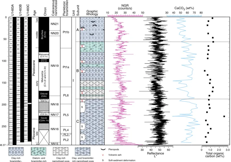
The sediment cored at Site U1482 is assigned to a single litho-logic unit composed of ~535 m of upper Miocene to Pleistocene nannofossil ooze/chalk with varying amounts of clay and foramini-fers (Figure F8). Lithologic Unit I is divided into four subunits. Sub-unit IA is an ~120 m thick sequence of Pleistocene light greenish gray clay-rich nannofossil ooze. This subunit contains pteropods and is largely homogeneous with variable amounts of clay. In the lowermost 40 m of the subunit, dark–light bedding cycles become more evident. The boundary between Subunits IA and IB marks a sharp transition between darker clay-rich foraminifer-rich nanno-fossil ooze and dominantly lighter nannonanno-fossil ooze. Subunit IB (early Pliocene to earliest Pleistocene) is an ~90 m thick greenish gray nannofossil ooze, with clay content increasing toward the mid-dle of the subunit and then decreasing again toward the base. The middle part of Subunit IB also contains an interval of significant soft-sediment deformation at ~150 mbsf. Sulfide specks and nod-ules are abundant, and foraminifer content increases toward the
bottom of the subunit. The base of Subunit IB is the first downhole
occurrence of well-defined light–dark cycles. Subunit IC (~160 m thick) consists of upper Miocene to lowermost Pliocene light green-ish gray nannofossil ooze with varying abundances of foraminifers and clay. This subunit shows strong color cyclicity at a section scale, with cycles largely reflecting changes in carbonate content (~80 to 50 wt%). Sulfide patches are abundant throughout. The base of the subunit is defined by the transition from ooze to chalk, which corre-sponds to the switch from the HLAPC to XCB coring system in Hole U1482A. Subunit ID is composed of upper Miocene light greenish gray chalk with low abundances of clay. Color cycles are on the order of 1.5 to 2 m thick in this subunit. Dissolution of foramin-ifers has resulted in moldic porosity within the chalk. Foraminforamin-ifers are also occasionally concentrated in discrete layers in Subunit ID.
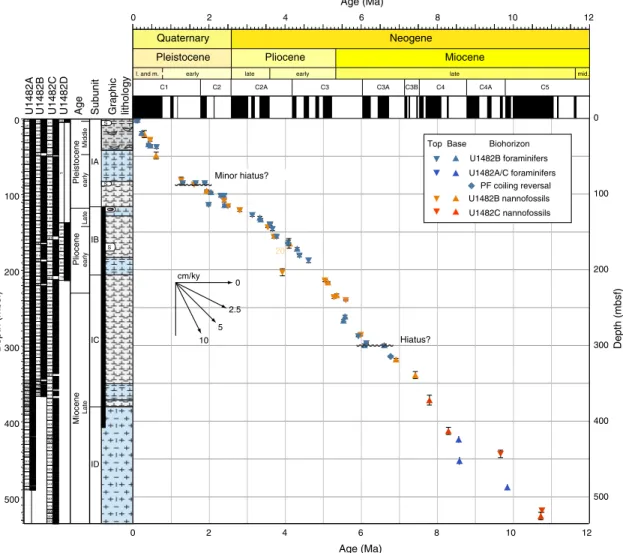
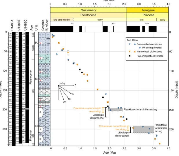
Calcareous nannofossils and planktonic foraminifers are abun-dant and benthic foraminifers are present throughout the recovered succession at Site U1482 and generally show very good to excellent preservation. Planktonic/benthic ratios are typically 99:1. The age model for Site U1482 is based on calcareous nannofossil and plank-tonic foraminifer biostratigraphy (Figure F9). The base of the late Pleistocene is placed at ~3 mbsf, between biohorizon top Globigeri-noides ruber (pink) (0.12 Ma) and biohorizon base Emiliania hux-leyi (0.29 Ma). The base of the middle Pleistocene is placed between 47 and 80 mbsf, between the top of Globorotalia tosaensis (0.61 Ma) and the top of Helicosphaera sellii (1.26 Ma). There is strong evi-dence for sedimentary disturbance and reworking in the lower and middle Pleistocene with the potential for missing section in the up-per part of the lower Pleistocene. The Pliocene/Pleistocene
bound-ary is placed at 118 mbsf (Figure F8). There are concentrations of
planktonic foraminifer biohorizons at ~102–103 mbsf (~1.3–1.9 Ma) and 300 mbsf (~6.1–6.6 Ma), suggesting condensed intervals or hiatuses. This is less clear in the calcareous nannofossil bio-horizons, although nannofossil age control is sparse at both of these levels. Otherwise, sedimentation appears continuous throughout
the upper Miocene and lower Pliocene interval (Figure F9). The age
at the base of the recovered succession is constrained as <10.47 Ma by the absence of the planktonic foraminifer Paragloborotalia may-eri in the lowermost sample examined, although calcareous nanno-fossil assemblages suggest a slightly older age of ~10.75 Ma. Calcareous nannofossil and planktonic foraminifer biohorizons are in generally good agreement and indicate sedimentation rates of ~5.9 cm/ky during the late Miocene, decreasing to ~3.3 cm/ky in the early Pliocene. The Pleistocene is characterized by higher
sedi-mentation rates of ~7 cm/ky (Figure F9).
Paleomagnetic investigations at Site U1482 measured natural remanent magnetization (NRM) of archive halves from Holes U1482A–U1482C before and after demagnetization in a peak alter-nating field (AF) of 15 mT, which effectively removed the vertical overprint induced by the drill string. Fifty discrete samples were taken to investigate paleomagnetic carriers and rock magnetic properties. NRM15mT intensity is higher (~10–4 A/m) in the upper
40–60 mbsf of each hole, decreases between 60 and 90 mbsf, and
remains low (~10–5 A/m) below ~90 mbsf where it approaches the
measurement noise level of the magnetometer. Decreases in mag-netic intensity downhole are accompanied by decreases in other ferrimagnetic concentration parameters (anhysteretic remanent magnetization [ARM] and isothermal remanent magnetization
[IRM]), a halving of the NRM15mT/NRM intensity, and a coarsening
of magnetic grain size (lower ARM/saturation remanent magnetiza-tion [SIRM]). These changes are coeval with decreases in interstitial water sulfate and the appearance of pyrite in the sediment associ-ated with the reduction of primary ferrimagnetic oxides and forma-tion of secondary iron sulfides during early sediment diagenesis. In the upper 50–70 mbsf, inclinations plot around those expected for the site latitude assuming a geocentric axial dipole (GAD) field. Az-imuthally corrected declination using the Icefield MI-5 tool is largely consistent between successive cores but maintains an abso-lute offset of 150°–180° (i.e., corrected values for normal polarity cluster between 150° and 180° instead of 0°). Relatively weak mag-netic susceptibility coupled with reduction of ferrimagmag-netic oxides results in a largely uninterpretable signal below the iron-reduction zone and restricts our geomagnetic interpretation to the upper 50– 70 mbsf. Sediment in this zone appears to have been deposited during a period of normal polarity consistent with the Brunhes Chron (C1n).
The physical property data collected for Site U1482 includes P-wave velocity, gamma ray attenuation (GRA) bulk density, magnetic susceptibility (MS), natural gamma radiation (NGR), and thermal conductivity on whole-round cores from Holes U1482A–U1482D and additional measurements on split cores and discrete samples including P-wave velocity; porosity; and bulk, dry, and grain densi-ties. Thermal conductivity was also measured on split cores when the sediment became too indurated to use the needle probe. Despite the relatively homogeneous lithology dominated by nannofossil ooze at this site, physical property parameters display broad-scale features and high-resolution cyclicity throughout the sequence
(Fig-ure F8). A downhole, linear increase is superimposed on these
high-frequency cycles in thermal conductivity (~1.0–1.5 W/[m·K]), GRA
bulk density (~1.4–2.0 g/cm3), and moisture and density (MAD) dry
whereas porosity decreases with depth from ~75% to 45%, repre-senting increasing compaction with depth. Notably, GRA bulk den-sity, NGR, and MS exhibit a broad peak centered at ~175 mbsf, which coincides with an interval of soft-sediment deformation
ob-served in all holes (Figure F8). Formation temperature
measure-ments made with the advanced piston corer temperature tool (APCT-3) on Cores 363-U1482A-4H, 7H, 10H, and 13H indicate a geothermal gradient of 48°C/km for the upper ~120 mbsf.
Tie points for stratigraphic correlation were established mainly with Whole-Round Multisensor Logger (WRMSL) MS data, al-though some were based on WRMSL GRA bulk density and NGR data. Correlation was challenging due to intervals with very low am-plitude variability in the WRMSL and NGR signals, the presence of intervals containing soft-sediment deformation, and variations in the size of core gaps resulting from a large tidal range of 3–4 m during coring operations at Site U1482. The core composite depth below seafloor (CCSF) depth scale is anchored to the mudline Core 363-U1482B-1H, which is assigned the depth of 0 m CCSF. From this anchor, we worked downhole to establish a composite strati-graphy on a core-by-core basis. We developed a splice from 0–451.2 m CCSF and a composite depth scale to 614.6 m CCSF. The match between the holes is well constrained within the splice except for intervals of soft-sediment deformation (0–17, 55–84, 104–111, and 207–210 m CCSF) and one core gap at 401 m CCSF. Below 451 m CCSF, we determined tentative correlations between some cores but did not construct a splice, which should be explored as part of postcruise research.
The inorganic geochemistry of Site U1482 is strongly influenced by the remineralization of organic matter. Total organic carbon (TOC) content is >1.0 wt% in the uppermost ~100 mbsf (Figure F8), which is relatively high for an open marine setting. The sediment rapidly becomes suboxic, as evidenced by a [Mn2+] peak in the inter-stitial water profile at ~20 mbsf. Sulfate reduction occurs until ~120 mbsf, where near-complete sulfate depletion is accompanied by a rapid increase in methane. This sulfate–methane transition zone
(SMTZ) is also marked by a pronounced increase in [Ba2+] in the
interstitial water, reflecting both authigenic precipitation and
disso-lution of sedimentary barite (BaSO4) in underlying sediment. Peak
alkalinity and [Si] values observed between 0 and 120 mbsf indicate organic matter and biogenic silica remineralization, respectively. The steady increases in [NH4+] and [Br–] are also consistent with
this progressive remineralization of organic matter. Calcium and magnesium concentrations decrease in the upper 120 mbsf, possi-bly reflecting calcite precipitation. A similar trend of decreasing phosphate suggests possible precipitation of apatite, although over-all [PO43–] is quite low (<10 μM). Below 120 mbsf, [Mg2+] continues
to decrease, whereas [Ca2+] shows a slight increase. Although this
suggests precipitation of dolomite, downhole trends in [K+], [B], and [Li+] indicate that ion exchange with clay minerals could contribute
to the trends observed in the interstitial water profiles.
Hydrocarbon monitoring shows high methane concentration below the SMTZ, with an average of 6%. However, the ratio of methane to ethane, as well as the gas wetness index, suggests that most of the gas has a biogenic origin. Methane concentrations de-crease to ~3% between ~380 and 530 mbsf, reflecting progressive depletion of available organic matter for methanogenesis. Both eth-ane and propeth-ane profiles largely follow metheth-ane, but also respond to the increased thermal maturity following the geothermal gradi-ent.
The carbonate content at Site U1482 fluctuates between 0 and
180 mbsf, with an average of ~60 wt%. Below 180 mbsf, CaCO3
con-tentincreases to ~80 wt%, possibly reflecting the late Miocene to
early Pliocene “biogenic bloom” that is most pronounced in the Indo-Pacific region (e.g., Farrell et al., 1995; Gupta and Thomas, 1999).
Two downhole logging tool strings were run in Hole U1482C, the triple combo (NGR, porosity, density, electrical resistivity, and MS) and the FMS-sonic (NGR, sonic velocity, and electrical resis-tivity images) tool strings. The triple combo tool string reached to the bottom of the hole at 533.4 m WSF, whereas the FMS-sonic tool sting reached only to 517 m WSF after encountering fill. One of the four FMS pads performed poorly; however, postacquisition pro-cessing corrected the problem. Caliper data show that the borehole was enlarged by ~2.5–10 cm in the upper 250 mbsf, which affected the quality of the density and porosity measurements and resulted in higher variability in those data. Deeper than 350 mbsf, corre-sponding to the depth where we switched to XCB coring, the bore-hole walls were remarkably smooth. This interval corresponds to lithologic Subunit ID, which consists of chalk.
The composite gamma ray log shows an increase between 118 and 207 m wireline matched depth below seafloor (WMSF) (Sub-unit IB), which correlates with an increase in NGR measured on cores, indicating a higher proportion of clay over that interval. Shal-low and deep resistivity measurements show consistent offset downhole, indicating that there was little or no fluid invasion into the formation. P-wave velocities increase steadily downhole to roughly 2000 m/s at the bottom of the hole. Discrete z-axis P-wave measurements on cores provide an estimate for the interval from the seafloor to the bottom of the drill pipe at 74.7 m drilling depth below seafloor (DSF). Combining these data, we were able to estab-lish a velocity profile to the bottom of the hole and derive reliable calculations of depths to key reflectors in the seismic data crossing Site U1482.
Site U1483
Background and objectivesSite U1483 (proposed Site WP-11B) is located on the northwest
Australian margin at 13°5.24′S, 121°48.25′E and 1733 mbsl (Figure
F7). The site is situated on seismic Line BR98-117, 1300 m
north-east of the intersection with seismic Line BR98-168 and ~0.8 nmi southeast of the ~40 m long piston Core MD01-2378, which pro-vides insights into late Pleistocene sedimentation and stratigraphy at this location (e.g., Holbourn et al., 2005; Kuhnt et al., 2015). The interpretation of Miocene seismic reflectors is based on comparison to the Australian Geological Survey Organisation regional seismic survey Line 119-04 (well control by Buffon 1 and Brewster 1A) and the BBHR Line 175/10 (well control by Argus 1). A major unconfor-mity marks the top of the prograding sequence at 0.72 s TWT below seafloor and is interpreted as the middle Miocene sequence bound-ary corresponding to a major sea level drop associated with rapid expansion of the Antarctic Ice Sheet (Mi-3; 13.8 Ma) (Rosenthal et al., 2016).
Site U1483 is situated on the Scott Plateau at the northwestern
margin of northeast-trending Browse Basin (Figure F7), which
un-derlies the Australian northwest margin between the onshore Kim-berley Basin and the Scott Plateau (Symonds et al., 1994). This region is adjacent to some of the oldest ocean crust still in the world’s ocean (Argo Abyssal Plain) formed after the breakup of Gondwanaland and the separation of northwest Australia from a Tethyan landmass (Gradstein et al., 1992). The Mesozoic section beneath the Scott Plateau is strongly influenced by breakup-related tectonism and forms the acoustic basement through much of the
Scott Plateau area (Stagg and Exon, 1981). The postbreakup sedi-mentary succession forms an ~2000 m thick, relatively uniform blanket over the Scott Plateau and the northeastern margin of Browse Basin. Site U1483 is located south of the Sunda arc, where ongoing collision between Australia and the Eurasia/Pacific arc sys-tem has occurred since the Miocene (Keep et al., 2007; Hall, 2012). However, intense Neogene faulting is mainly observed in the south-ernmost parts of Browse Basin (Barcoo Subbasin), whereas the northern parts are relatively devoid of intense Neogene deforma-tion (Keep et al., 2007).
Site U1483 is located ~264 km northeast of Site U1482. Both sites are within the hydrographic transition that separates the warm tropical water of the IPWP from subtropical water masses. Jointly, the two sites are suitable to monitor changes in the southward ex-tent of tropical warm water related either to circulation or global climate trends. Both sites are close to the oceanographic front be-tween relatively cool, nutrient-rich water carried northward in the Eastern Indian Ocean by the West Australian Current and warm, oligotrophic Leeuwin Current waters, which results in a steep
north–south SST gradient (Figure F1).
The sedimentation rate at Site U1483 is ~9 cm/ky (Holbourn et al., 2005), which is twice the rate than that at Site U1482. Combined, the two sites will allow reconstruction of the southwestern extent of the IPWP since the early late Miocene. Furthermore, the sites are located along the route of the ITF as it exits into the Indian Ocean through the Timor Strait between northwestern Australia and Java (Figure F7). The Timor Strait is one of the three main exits of the ITF to the Eastern Indian Ocean (Gordon, 2005). Thus, Sites U1482 and U1483 are ideally located to monitor changes in the intensity and thermal structure of ITF water masses entering the Eastern In-dian Ocean (e.g., Xu et al., 2008).
Operations
After a 142 nmi transit from Site U1482, the vessel stabilized over Site U1483 at 0630 h (all times are local ship time; UTC + 8 h)
on 26 October 2016. We cored three holes at Site U1483 (Table T1).
The original operations plan called for coring to APC refusal (esti-mated at 250 mbsf ) followed by two additional holes deepened to 350 mbsf using the XCB coring system. Instead, we cored three holes using the APC to ~290 mbsf, the depth at which we encoun-tered APC refusal. We decided not to deepen the holes to the origi-nal planned total depth because we had already reached our primary age target.
Hole U1483A was cored with the APC using orientation and nonmagnetic hardware to 293.3 mbsf (Cores 363-U1483A-1H through 31H), where a partial stroke indicated APC refusal. Down-hole temperature measurements using the APCT-3 were taken on Cores 4H (37.1 mbsf ), 7H (65.6 mbsf ), 10H (94.1 mbsf ), and 13H (122.6 mbsf ), obtaining reliable results on three of the four deploy-ments. A total of 308.58 m of sediment was recovered over 293.3 m of coring (105.2% recovery) in Hole U1483A.
Hole U1483B was cored with the APC using orientation and nonmagnetic hardware to 287.0 mbsf (Cores 361-U1483B-1H through 31H). A total of 301.62 m of sediment was collected over this interval (105.1% recovery). Oriented APC coring with nonmag-netic hardware continued in Hole U1483C and reached 284.8 mbsf (Cores 361-U1483C-1H through 31H). One drilled interval (3 m) advanced the hole without coring to avoid alignment of core gaps for stratigraphic correlation. A total of 292.42 m of core was recov-ered over 281.8 m of coring (103.8% recovery). Operations at Site
U1483 ended at 0800 h on 30 October. Total time spent on the site was 97.5 h (4.1 days).
A total of 92 APC cores were recovered at this site, collecting 902.62 m of sediment over 862.1 m of penetration (105% recovery). Principal results
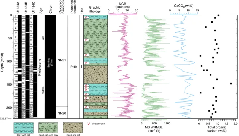
The sediment cored at Site U1483 is assigned to a single litho-logic unit composed of ~293 m of lower Pliocene to recent nanno-fossil ooze with variable amounts of clay, foraminifers, and siliceous
microfossils (primarily diatoms and radiolarians) (Figure F10).
Tephra layers occur sporadically throughout the unit. Lithologic Unit I is divided into three subunits. Subunit IA is an ~56 m se-quence of middle Pleistocene to recent greenish gray clay-bearing and clay-rich nannofossil ooze. Sponge spicules and mollusk shell fragments are common throughout this subunit, whereas pteropods are restricted to the upper 40 mbsf. Alternations between dark greenish gray and light greenish gray sediment at multiple-meter scale are apparent and also recorded in NGR and L* records. The boundary between Subunits IA and IB is defined by the first down-hole appearance of brownish gray diatom-rich nannofossil ooze. Subunit IB (early to middle Pleistocene) is an ~130 m thick se-quence of greenish gray clay-rich nannofossil ooze, diatom-rich nannofossil clay, and clay-rich diatom–nannofossil ooze. This sub-unit is distinguished by higher biosiliceous content than that in Sub-unit IA. Clay content increases toward the bottom of SubSub-unit IB. Color alternations are at the section scale (~1.5 m), which is more frequent than in Subunit IA. The darker colored intervals have higher siliceous microfossil and organic matter content than the lighter colored intervals. Shell fragments are also common through-out this subunit. The boundary between Subunits IB and IC is de-noted by a significant reduction in the abundance of siliceous microfossils. Subunit IC is composed of ~105 m of greenish gray foraminifer-rich nannofossil clay. Two significant intervals of
soft-sediment deformation occur in this subunit (Figure F10). The upper
unit is ~24 m thick, whereas the lower unit has varying thicknesses among the holes. These intervals include inclined bedding, folding, and microfaulting. Dark gray clay layers that exhibit high bulk den-sity also occur in the deformed intervals.
The 293 m succession recovered at Site U1483 contains abun-dant, diverse, tropical calcareous nannofossil and planktonic fora-minifer assemblages. Planktonic forafora-minifers dominate the >63 μm size fraction; however, other microfossil groups are also present and include benthic foraminifers, radiolarians, silicoflagellates, and oc-casionally ostracods. The planktonic/benthic foraminifer ratios are typically 99:1. Preservation is generally excellent to very good throughout the entire succession, although a minor decrease in preservation is noted with depth.
Integrated calcareous nannofossil and planktonic foraminifer biostratigraphy, together with magnetostratigraphy, indicate that the succession at Site U1483 spans the late early Pliocene to the
re-cent (Figure F11). Calcareous nannofossil and planktonic
foramin-ifer biohorizons are generally in good agreement. The age at the bottom of the recovered succession is >3.59 Ma based on the pres-ence of Sphaeroidinella seminulina. Biostratigraphy in the lower-most part of the recovered section (~293–260 mbsf ) suggests sedimentation rates of ~10 cm/ky during the late early Pliocene. The interval between ~260 and 193.5 mbsf includes two packages of disturbed sediment. A clustering of biohorizons around 260–243 mbsf coincides with the deeper disturbed interval and is overlain by what appears to be intact stratigraphy, with another interval of