Publisher’s version / Version de l'éditeur:
Proceedings 8th International Offshore and Polar Engineering Conference,
ISOPE'98, 2, pp. 586-591, 1998-05-24
READ THESE TERMS AND CONDITIONS CAREFULLY BEFORE USING THIS WEBSITE.
https://nrc-publications.canada.ca/eng/copyright
Vous avez des questions? Nous pouvons vous aider. Pour communiquer directement avec un auteur, consultez la première page de la revue dans laquelle son article a été publié afin de trouver ses coordonnées. Si vous n’arrivez pas à les repérer, communiquez avec nous à PublicationsArchive-ArchivesPublications@nrc-cnrc.gc.ca.
Questions? Contact the NRC Publications Archive team at
PublicationsArchive-ArchivesPublications@nrc-cnrc.gc.ca. If you wish to email the authors directly, please see the first page of the publication for their contact information.
NRC Publications Archive
Archives des publications du CNRC
This publication could be one of several versions: author’s original, accepted manuscript or the publisher’s version. / La version de cette publication peut être l’une des suivantes : la version prépublication de l’auteur, la version acceptée du manuscrit ou la version de l’éditeur.
Access and use of this website and the material on it are subject to the Terms and Conditions set forth at
Canadian Ice Regime System Database.
Timco, Garry; Morin, Isabelle.
https://publications-cnrc.canada.ca/fra/droits
L’accès à ce site Web et l’utilisation de son contenu sont assujettis aux conditions présentées dans le site LISEZ CES CONDITIONS ATTENTIVEMENT AVANT D’UTILISER CE SITE WEB.
NRC Publications Record / Notice d'Archives des publications de CNRC:
https://nrc-publications.canada.ca/eng/view/object/?id=9d177e83-e087-4282-a9ab-664ece4c097c
https://publications-cnrc.canada.ca/fra/voir/objet/?id=9d177e83-e087-4282-a9ab-664ece4c097c
Proceedings of Eighth (1998) International Offshore and Polar Engineering Conference Montreal, Canada, May 24-29, 1998
Proceedings ISOPE’98, Vol. II, pp 586-591
Canadian Ice Regime System Database
G.W. Timco and I. MorinCanadian Hydraulics Centre National Research Council of Canada
Ottawa, Ont. K1A 0R6 Canada
ABSTRACT
Transport Canada has proposed extensive revisions to the Canadian Arctic Shipping Pollution Prevention Regulations (ASPPR 1989). In part, these changes make use of actual ice conditions, and define the conditions in which vessels can navigate in ice-covered waters. The system is based on the quantity of hazardous ice. Transport Canada approached the Canadian Hydraulics Centre of the National Research Council to assist them in developing a scientific basis for the Ice Regime System, which is at present based on operational experience. A seven-step approach was developed to do this. A major part of this process was the development of a comprehensive database that would relate ship damage to ice conditions and environmental factors. This paper describes the development, design and format of the database. It also includes a few examples of the types of queries that can be performed with the information in the database.
KEYWORDS: Ice regime, ASPPR, ships, damage, safety, database.
INTRODUCTION
Navigation in Canadian waters north of 60°N latitude is regulated by Shipping Safety Control Zones. At the present time, a “Zone/Date” matrix gives entry and exit dates for various ship types and classes. It is a rigid system with little room for exceptions. It is based on the premise that nature consistently follows a regular pattern year after year. Transport Canada, in consultation with stakeholders, has proposed extensive revisions to the Canadian Arctic Shipping Pollution Prevention Regulations (ASPPR 1989; TC-RIAS 1996; AIRSS 1996). The changes are designed to reduce the risk of structural damage in ships which could lead to the release of pollution into the environment, but provide the necessary flexibility to ship owners by making use of actual ice conditions, as seen by the Master. In this new system, an "Ice Regime", which is a region of generally consistent ice conditions, is defined at the time the vessel enters that specific geographic region, or it is defined in advance for
planning and design purposes. The Arctic Ice Regime Shipping System (AIRSS) is based on a simple arithmetic calculation that produces an “Ice Numeral” that combines the ice regime and the vessel’s ability to navigate safely in that region. The Ice Numeral (IN) is based on the quantity of hazardous ice with respect to the ASPPR classification of the vessel (see Table 1) and is calculated from Equation 1. [Equation 1.]
∑
==
n i i iF
M
IN
1In Equation 1, Fi represents the fraction (in 10th) of ice of a
certain type and Mi the Ice Multiplier for that ice type and a given
ship category as shows in Table 2. The values of the Ice Multipliers are then adjusted to take into account the decay or ridging of the ice by adding or subtracting a correction of 1 to the multiplier, respectively.
The Regulation deals with both vessels that are designed to operate in extreme ice conditions for both transit and IceBreaking (CAC class) as well as vessels designed to operate in more moderate first-year ice conditions (Type vessels). The System determines whether or not a given vessel should proceed through that particular ice regime. If the Ice Numeral is negative, the ship is not allowed to proceed. However, if the Ice Numeral is zero or positive, the ship is allowed to proceed into the ice regime. Responsibility to plan the route, identify the ice, and carry out this numeric calculation rests with the Navigation Officer in charge of the bridge watch. Due care and attention of the mariner, including avoidance of hazards, such as growlers and multi-year ice, is vital to the successful application of the Ice Regime System. Authority by the Regulator to direct ships in danger, or during an emergency, remains unchanged.
Credibility of the new system has wide implications, not only for ship safety and pollution prevention, but also in lowering ship insurance rates and predicting ship performance. Therefore, there is a need to establish a scientific basis for the system. To this end, Transport Canada approached the National Research Council of Canada in Ottawa to assist them in developing a methodology for establishing a scientific basis for AIRSS. This led to a "road map" approach that is based on 7 Tasks (Timco and
Frederking 1996; Timco et al. 1997). A major part of these Tasks was the development of a comprehensive database that contains information on ships in ice. The database had to contain information on a large number of different ships and ship classes, with travel though a wide range of ice conditions. In this paper, the philosophy, structure and form of this database is discussed, and information on the format and current status of the database is presented.
Table 1: Vessel Ice Class and Operating Role.
ICE TYPE RANGE SHIP CATEGORY
OPERATING ROLE (m)
Multiyear Ice > 3 CAC 1 Unrestricted Second Year Ice > 2 CAC 2 Transit & IB Thick First Year Ice > 1.2 CAC 3 Transit & IB Medium First Year Ice 0.7 - 1.2 CAC 4 Transit & IB Thin First Year Ice - 2nd Stage 0.5 - 0.7 TYPE A Transit
Thin First Year Ice - 1st Stage 0.3 - 0.5 TYPE B Transit Grey-White Ice 0.15 - 0.3 TYPE C Transit Grey Ice 0 - 0.15 TYPE D Transit Open Water 0 TYPE E Transit
Table 2: ASPPR Ice Multipliers.
Ship Category TYPE CAC Ice Type E D C B A 4 3 MY -4 -4 -4 -4 -4 -3 -1 SY -4 -4 -4 -4 -3 -2 1 TKFY -3 -3 -3 -2 -1 1 2 MFY -2 -2 -2 -1 1 2 2 THFY2 -1 -1 -1 1 2 2 2 THFY1 -1 -1 1 1 2 2 2 GW -1 1 1 1 2 2 2 G 1 2 2 2 2 2 2 OW 2 2 2 2 2 2 2
OVERVIEW OF THE DATABASE
Considerable effort was spent in developing the overall philosophy and approach for the Ice Regime System database (Timco and Morin 1997). The following factors were considered: 1. The database had to include both damage and non-damage Events. Thus, although some existing databases could be used as a starting point, a significant amount of additional data was required that reflected safe passage in different ice regimes;
2. The database had to include a number of very fundamental pieces of information that related to the vessels’ speed and displacement, the ice conditions, and the environmental conditions during an Event;
3. Although the database could be developed solely to support this ice regime project, it was felt that its use would be increased significantly with the addition of some ancillary information. In particular, the information might be used in the Harmonization of Regulations related to ships in ice, for Arctic marine transportation planning, training to Arctic navigators, as well as guidance to
masters in general, and to Arctic Pollution Prevention Officers in the conduct of their duties;
4. The ability to add to the database in the future; and
5. To maintain anonymity of the information for research purposes.
Based on these criteria, an overview approach for the information in the database was developed. The database is structured with a distinction between two main types of information:
1. Information that refers to an Interaction Event. This information refers to one situation of a specific vessel traversing a specific ice regime.
2. Information that refers to the Vessel Characteristics. This information is specific for each vessel, but the same for each Interaction Event.
The details are discussed in the following sections.
INFORMATION ON INTERACTION EVENTS
The information on the Interaction Events contains the essential components required for the Ice Regime System database. It contains fields of information relating to a specific “Interaction
Event”. In this case, each ship interaction with a specific ice
regime is identified as an Event. Thus, on any specific voyage of a vessel in ice, there could be several different Events for different segments of a voyage. This information is sub-divided into 2 categories according to whether the information is essential for the ice regime system, or whether the information is ancillary, i.e. important, but not essential. There are seventy-nine fields that relate to the specific interaction Events:
GENERAL - Three fields identify each Event: Interaction Event Number, Original Source and Number in Original Source.
SHIP CHARACTERISTICS - Six fields identify the key information related to the vessel during the Event: Name of Vessel, Displacement during Event, Average Speed during Event, Maneuvering Speed during Event, Draft FWD (at Event), Vessel Movement at Event, and Cargo (at Event).
ROUTE - Nine fields describe the route of the vessel during the Event: Date of Event, Geographic Region, Latitude, Longitude, In/Out of Arctic?, Route Start Point, Route Destination, Distance of Event, and Country Legislating the Waters.
CLIMATE - Eight fields describe the meteorological conditions during the Event: Air Temperature, Visibility, Visibility – fog, Visibility – light, Visibility – snow, Wind Speed, and Sea State.
ICE CONDITIONS - Twenty-four fields represent the specific ice information during the Event: Ice Information Available, Concentrations WMO Ice Types, Total Ice Concentration, ASPPR Ice Numeral, Average Ice Temperature, Ice Temperature, Average FY (first-year) Ice Salinity, FY Ice Maximum Thickness, FY Ice Compressive Strength, FY Ice Flexural Strength, FY Ice Roughness, FY Ice Floe Size, MY (multi-year) Ice Thickness, MY Ice Compressive Strength, MY Ice Flexural Strength, MY Ice Roughness, MY Ice Floe Size, Glacial Ice, Ridging, Decaying Ice, Pressured Ice, Leads in Ice, Ice Description, AES Ice Chart Number, and Airborne SLAR/SAR Imagery.
DAMAGE - Twenty fields describe the damage: Damage?, Damage Location on Vessel, Damage Severity – shell, Damage Severity Number, Scenario Type, Description of Damage, Damage Code, Cause of Damage, Damage - Distance below WL, Damage - Size – length, Damage - Size – height, Steel Failure Type, Apparent Accessibility, Pictures, Damage Report Number, Master’s Report, ISS Report, Cost to Repair, Cost of Downtime, and Pollution resulting from damage
OTHER INFORMATION - Eight fields provide additional information on the Event: Experience with Ice Regimes, Escort Vessel?, Escort Vessel Name, Escort Vessel Class, AES Airborne SLAR/SAR, On-board Ice Systems, Voyage Constraints, and Comments.
INFORMATION ON SHIP CHARACTERISTICS
The second main source of information is related to the Characteristics of the Ship. All of this information relates to the general properties of the ships, and they are not specific to any particular Event. That is, the information relates to, for example, the ship length, owner, etc. which is common for a particular vessel. There are twenty fields related to the ship characteristics: Name of Vessel, ASPPR Ice Class, Bow shape, Stem Angle, Class, Type of Vessel, Owner, Country of Origin, Year of Manufacture, Length, Beam, Depth, Tonnage GRT, Tonnage DWT, Propulsion Plant, Power, Number of Propellers, Propeller Type, Stern Form and Steel Grade.
RELATIONAL DATABASES
In order to store, extract and analyze the vast quantity of information on the many interaction events, a relational database was designed. This database facilitates the analysis of results and allows for regular updates of the data. The main advantage of a computerized database is the ease with which the information it contains can be extracted and analyzed. With this approach, it is possible to determine the ship characteristics (for example, the displacement, speed and power) at the time of the event, and the ice conditions that caused the damage. Further, analysis can readily be done to relate the damage potential (e.g. energy of impact, hull stresses, etc.) to the ice regime and identify the combination where no damage, minor damage and important damage occur.
The information discussed above was organized into a number of “Tables” that comprise the various components of the database. The database was configured with two main tables, one related to the Interaction Event, and the other to the Ship Characteristics. This separation was chosen to preserve data integrity, since the same information should be stored at only one location of the database. The field “Name of Vessel” ties the Interaction Events information to the Ship Characteristics information. Only one ship may be involved in a given Event of the database, while a given ship may be involved in more than one Event. This constitutes a "one-to-many" relationship, which is a powerful and space-saving feature of the database. Microsoft Access97 was used as the database platform and was selected for its inter-operability with the other Windows applications. Figure 1 shows the relationship between the two tables, and presents an overview of the information in the database.
Event number Movement ID Glacial? Confidential? Visibility distance Ridging? Original source Visibility Decaying? Number in original source Snow Pressured?
Name of vessel Wind Leads?
Date Total concentration Geographic location Ice numeral
Latitude Ice severity
Longitude Ice temperature Country legislating waters FY salinity
In Arctic? FY thickness
Origin FY flexural
Destination FY compressive Distance of voyage FY roughness
Displacement MY thickness Average speed MY flexural
Manoeuvering speed MY compressive
Draft MY roughness…
Ship / Ice Interaction Event
Name of vessel ASPPR class Lloys’s class Baltic class Type of vessel Owner Country of origin Year Shape Stem angle Length Beam Depth Tonnage GRT Tonnage DWT… Ship Characteristics
Figure 1: Overview of the relationship between the ship/ice interaction events, showing some of the fields defined in the database.
SOURCES OF DATA
Since the database must be designed to define specific problems with the corresponding ice conditions, a large number of specific examples of ship-ice problems have to be detailed. In particular, it is important to analyze available data on ship transit to develop an understanding of the ice characteristics that caused problems for the ship, as well as any other extrinsic circumstances. The data must include Events where both damage and no-damage occurred. A number of different data sources have been used to provide information.
A literature review was carried out to extract relevant ship transits in ice. Reports were obtained that describe the travels of vessels in ice, some of which had been used in developing and assessing the Ice Regime System. The report by Norland and AKAC (1993) provided information that summarized a number of damage events in the Canadian Arctic. In addition to this, information from ship trials that were done to assess the Ice Regime System were analyzed and included in the database (see Norland 1994). These trials provided a number of important non-damage data events. To expand the scope of the database, information on specific ship voyages was solicited from various commercial and government organizations. In some cases, the information obtained was classified as “confidential” and measures have been programmed into the database to protect the confidentiality of these specific events.
Each of the available sources of information was carefully reviewed and as much relevant information as possible was extracted from the information presented. In virtually every case, however, complete information, as required by the defined database fields, was not provided. There was, in fact, a wide range in the quantity and quality of the information. This lack of complete information is understandable, since the fields identified for the database are very wide-ranging and comprehensive. Nevertheless, missing information will hamper the evaluation in many cases, and restrict the number of Events used in any specific analysis. For example, the speed of the vessel is an important field, and it is often used to evaluate the
data to investigate trends. Ideally the speed of the vessel should be provided, especially if there is damage to the vessel. Often, however, it is not explicitly given, and in some cases, the value had to be inferred from other supplied information. This aspect can be mostly overcome by having a large number of Events in the database which have been scrutinized for completeness and accuracy of information.
STATUS OF THE DATABASE
There are presently over one thousand Events in the database covering both damage and non-damage events. Approximately 12% of the Events are associated with damage Events, whereas the remaining 88% represent safe transit. It should be noted that this distribution reflects the Events in the database at this time, and is not reflective of the probability of a ship sustaining damage in any given ice condition. This overall distribution, however, can be sub-divided to look at the number of damage and no-damage Events for different Ice Numerals. Figure 2 shows that the proportion of damage Events to non-damage Events is high for low Ice Numerals, and decreases with increasing Ice Numeral. This trend provides support for the overall concept used to define the Ice Numeral. Figure 3 shows the distribution of damage and non-damage events based on the vessel type in the database, while Figure 4 shows the damage location for all the 139 damage events.
The computerized database allows one to “query” the database and extract information based on various criteria. A query contains a subset of the data that respect conditions specified in the query definition. The queries can easily be programmed to extract data using complex multi-variable criteria. For example, it is possible to ask the database to extract records that respect complex conditions such as "all Events between "start-date" and
"end-date", for which there is severe damage but where ice condition are under a certain level". This is only one example of
how powerful a tool the database can be for evaluating scenarios and supporting decisions. In this section, a few representative examples are presented. It should be emphasized, however, that these examples are meant to show the versatility of the database. They should not be used to infer the scientific merit of the Ice Regime System. Additional data will be incorporated and further data verification is required before the database can be used to form the scientifically-based system.
Figure 5 shows the damage severity as a function of the vessel speed and Ice Numeral for all events in which the vessel speed is known. In this case, the damage has been sub-divided into three types – none, denting and serious. Note that the more serious damage takes place at high speed with low Ice Numerals. Figure 6 shows damage and non-damage events for Type B vessels due to the interaction with both first-year (FY) and multi-year (MY) ice conditions. Note the significant increase in damage due to the interaction events with multi-year ice.
The Ice Regime Database, with the wealth of information it contains, makes it possible to verify the existing definition of the Ice Numeral, and if not suitable, to define different algorithms for the calculation of a “modified” Ice Numeral that may better fit the observations. Figure 7 presents, in a bar chart, the percentage of damage event by Ice Numeral. There is a definite trend of increasing damage with more negative Ice Numerals. There is, however, a higher incidence of damage in the vicinity of –5 to 0, as compared to the range –10 to –5. This higher incidence of damage may be due to higher vessel speeds in this range when ice conditions are less severe, but the possibility of an impact
with an isolated floe is still present. The line superposed on Figure 7 illustrates the relationship that might be expected from an “ideal” Ice Numeral indicator, whereby the incidence of damage diminishes gradually as the Ice Numeral increases, and is practically null for positive Ice Numerals. The information in the Ice Regime Database can be used to study different algorithms for the calculation of a “modified Ice Numeral” and possibly obtain an indicator more representative of the data. Note that any defined algorithm can make use of all data fields in the database, including vessel speed, ridging, visibility, etc. Work will continue in this area of verifying the Ice Numeral definition, and if possible, refining it to provide a better representation of damage probability.
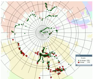
Another strength of the Ice Regime System database is that it can be linked to other applications and the data can be exchanged dynamically. An active connection was established between the Access97 database and a Geographical Information System (GIS) – MapInfo – whereby the latitude and longitude of the Events are used to position each event on a base-map of the Arctic. Figure 8 shows the spatial distribution of the damage and non-damage Events as displayed in the GIS application. This allows for a more intuitive interface into the database. With this approach, full details of any particular Event can be obtained by simply clicking, with the computer mouse, on the data point on the map. Queries can be programmed from this other interface and the results displayed spatially.
Figure 2: Distribution of damage and non-damage events versus Ice Numeral.
Figure 3: Distribution of damage and non-damage events by vessel type.
Figure 4: Distribution of damage location for the 139 damage events.
Figure 5: Severity of damage as a function of the average speed of the vessel and Ice Numeral.
Figure 6: Damage and non-damage events for Type B vessels due to interaction with first-year (FY) sea ice and multi-year (MY) sea ice.
Figure 7: Incidence of damage with ASPPR Ice Numeral and "idealized" distribution.
Figure 8: Spatial distribution of the Events in the database.
SUMMARY
This paper has presented an overview of the Ice Regime System Database developed by the Canadian Hydraulics Centre of the NRC to support Transport Canada regulations. This relational database contains information on over one thousand Interaction Events with different vessels in a wide range of different ice regimes. Data input has come from a wide number of sources with both damage and no-damage Events. The database has been structured to allow quick and easy analysis of a wide range of ship and ice characteristics. It can be used to verify the existing definition of the Ice Numeral compared to scientific data, and if necessary to re-define it using defined algorithms. Moreover, the information in the database can be linked to a GIS system for an informative and practical display of the Event information. The database will be used, in conjunction with Transport Canada and its stakeholders, to develop a scientific basis for the Arctic Ice Regime Shipping System.
ACKNOWLEDGEMENTS
The authors would like to thank Victor Santos-Pedro, Peter Timonin, Robert Wolfe, Bob Frederking, Brian Wright, Andrew Kendrick and Christopher Wright for their support and interest in the development of this work.
REFERENCES
AIRSS 1996. Arctic Ice Regime Shipping System (AIRSS) Standards, Transport Canada, June 1996, TP 12259E.
ASPPR, 1989. Proposal for the Revision of the Arctic Shipping Pollution Prevention Regulations. Transport Canada Report TP 9981, Ottawa. Ont., Canada.
Norland and AKAC, 1993. Ship Damage Database. Report prepared for Transport Canada, Ottawa, Ontario, Canada. Norland 1994. Field Evaluation Trial of the Proposed ASPPR Ice Regime System CCGS Des Groseilliers. Report to Canadian Coast Guard Northern, Transport Canada Report TP 11921, Ottawa, Ont., Canada.
TC-RIAS, 1996. Transport Canada, Regulatory Impact Analysis Statement, Canada Gazette, Part 1, June 15, 1996. Canada. Timco, G.W. and Frederking, R.M.W. 1996. A Methodology for Developing a Scientific Basis for the Ice Regime System. National Research Council of Canada Report HYD-TR-009, Ottawa, Canada.
Timco, G.W., Frederking, R.M.W. and Santos-Pedro, V.M. 1997, A Methodology for Developing a Scientific Basis for the Ice Regime System. Proceedings ISOPE’97, Vol II, pp 498-503, Honolulu, USA.
Timco, G.W. and Morin, I. 1997. Canadian Ice Regime Database. National Research Council of Canada Report HYD-TR-024, Ottawa, Canada.