Publisher’s version / Version de l'éditeur:
Vous avez des questions? Nous pouvons vous aider. Pour communiquer directement avec un auteur, consultez la première page de la revue dans laquelle son article a été publié afin de trouver ses coordonnées. Si vous n’arrivez pas à les repérer, communiquez avec nous à PublicationsArchive-ArchivesPublications@nrc-cnrc.gc.ca.
Questions? Contact the NRC Publications Archive team at
PublicationsArchive-ArchivesPublications@nrc-cnrc.gc.ca. If you wish to email the authors directly, please see the first page of the publication for their contact information.
https://publications-cnrc.canada.ca/fra/droits
L’accès à ce site Web et l’utilisation de son contenu sont assujettis aux conditions présentées dans le site
LISEZ CES CONDITIONS ATTENTIVEMENT AVANT D’UTILISER CE SITE WEB.
Technical Report (National Research Council of Canada. Ocean, Coastal and
River Engineering), 2018-10-02
READ THESE TERMS AND CONDITIONS CAREFULLY BEFORE USING THIS WEBSITE. https://nrc-publications.canada.ca/eng/copyright
NRC Publications Archive Record / Notice des Archives des publications du CNRC :
https://nrc-publications.canada.ca/eng/view/object/?id=787e9ae1-15f2-4cf9-849d-801e0d4aa974 https://publications-cnrc.canada.ca/fra/voir/objet/?id=787e9ae1-15f2-4cf9-849d-801e0d4aa974
NRC Publications Archive
Archives des publications du CNRC
For the publisher’s version, please access the DOI link below./ Pour consulter la version de l’éditeur, utilisez le lien DOI ci-dessous.
https://doi.org/10.4224/40000416
Access and use of this website and the material on it are subject to the Terms and Conditions set forth at
The Yukon River at Dawson City: assessment of factors influencing
freeze-up and ice bridge construction
TECHNICAL REPORT
OCRE-TR-2018-023
Unclassified
The Yukon River at Dawson City:
Assessment of factors influencing freeze-up and ice bridge construction
Technical Report OCRE-TR-2018-023 Paul Barrette Sean Ferguson Vahid Pilechi Naveed Khaliq
National Research Council Canada
Ocean, Coastal and River Engineering (OCRE) 1200 Montreal Rd, Ottawa, ON K1A 0R6
October 2, 2018
National Research Council Conseil national de recherches
Canada Canada
Ocean, Coastal and River Génie océanique, côtier et fluvial Engineering
The Yukon River at Dawson City:
Assessment of factors influencing freeze-up
and ice bridge construction
Technical Report
OCRE-TR-2018-023
Prepared for:
Highways and Public Works, Yukon Government
By:
National Research Council Canada (NRC)
National Research Council Conseil national de recherches
Canada Canada
Ocean, Coastal and River Génie océanique, côtier et fluvial Engineering
The Yukon River at Dawson City:
Assessment of factors influencing freeze-up
and ice bridge construction
Technical Report
OCRE-TR-2018-023
Paul Barrette Sean Ferguson Vahid Pilechi Naveed Khaliq October 2, 2018[Frontispiece: An opening in the Yukon River prevented the Dawson City ice bridge from being built in the winter of 2016-2017 (Jassin Godard/CBC)1].
OCRE-TR-2018-023 i
SUMMARY
The Dawson City ice bridge is located at the George Black Ferry crossing of the Yukon River – the ice bridge links the district of West Dawson to the main part of Dawson City east of the river (acting as a replacement to the ferry during the winter). The ice bridge is 400 m in length and its width is typically about 60 m. The bridge has been operated since the 1960’s by the Yukon Government (YG). It accommodates light traffic across the river as well as heavy-haul equipment that services the mining industry. There is no overlap between the ice bridge and ferry operations, i.e. there are time windows during which river crossing is not available. The ice bridge opening dates vary considerably, from early November to early February. Bridge closure usually occurs between the end of March and mid- to end of April. A gradual decrease of the yearly operational lifespan has been reported, i.e. 1.75 days/year since 1995.
The Yukon Government communicated to the National Research Council (NRC) that in the last few years, there was an open water lead in the center of the river. This occurred in the winters of 2013-14, 2016-17 and 2017-18. In the winter of 2013-2014, an alternative route for the bridge was necessary because the ice conditions did not allow it to be built at the usual location. In the two most recent cases, the open water channel prevented the construction of the ice bridge, thereby cutting off the link between West Dawson and Dawson City. The Yukon Government engaged the NRC to recommend areas of research (‘investigation avenues’) to determine why the river has not been freezing completely.
Consultation with the local community in Dawson City on the ice bridge operation was organized by YG. It took the form of an Open House, which was held on August 22nd 2018. The purpose of
this event was to gather feedback from the community – comments, questions, concerns – on the ice bridge operation. The discussions centered around eight themes: 1) General comments, 2) The river bottom, 3) Ice jams and other ice-related issues, 4) How ‘to bridge the gap’ – Booms, 5) Alternate route, 6) Operational aspects, 7) Safety, and 8) Moving forward.
Various environmental factors could prevent freeze-up. A brief overview of river ice dynamics is provided, pointing out the importance of flow velocity and air temperature amongst other factors, in determining freeze-up conditions. When drifting ice pieces are pushed against each other, they begin to overlap, and may occasionally develop into fields of ice blocks or hummocky ice that could induce what is known as ‘freeze-up ice jams’. Pieces of ice which could contribute to ice bridge initiation are prevented by the jam from drifting further downstream.
The sediment deposit located at the confluence of the Klondike River and the Yukon River near Dawson is characteristic of a channel junction bar and many mid-channel bars can be observed on the Yukon River upstream of Dawson. Such an evolving riverbed is conceivable, and could tentatively be linked with a possible increase in current speed at the George Black Ferry crossing.
Climate change is a complex phenomenon – it could affect the Yukon River’s freeze-up behavior in several ways. A number of investigation avenues may be envisaged, namely a physically-based regional climate model. Also, it would be helpful in understanding if a change in low flow
regimes is a causative factor. During low flow periods, rivers draw from groundwater. If winter low flows are increasing then that will be an indication that warmer water released from soil stores is a contributing factor. The influence of human activity, including operations at the Dawson City wastewater treatment plant (WWTP), may also play a role.
OCRE-TR-2018-023 ii
The Dawson City ice bridge has historically been a relatively successful operation. But these new circumstances – i.e. the existence of an open water lead – call for new or novel procedures and techniques. The conventional bridge building methods are no longer sufficient. New investigation avenues are therefore proposed, including: 1) Extending a line across the river channel, to act as a tow line to safely mobilize equipment across the channel; 2) recourse to an ice boom;
3) enhancing freeze-up with spray ice; 4) addressing the sand bar; 5) addressing the influence of Dawson City’s WWTP.
These might be considered in the short term, possibly for the winter of 2018-2019. Longer term strategies could include: 1) the design and implementation of a system to ensure this bridge will operate effectively and safely; 2) to examine all relevant databases that have not yet been collected and conduct analyses on those that exist and are available; and 3) to devise a field instrumentation scheme that would target data gaps and provide the required information to help optimize adaptation measures and complement the already existing databases.
OCRE-TR-2018-023 iii
Table of Contents
Summary ... i
Table of Contents ... iii
Table of Figures ... v
Table of Tables ... vii
1
Introduction
– Background on NRC involvement ... 1
1.1 Objectives of this Desktop Study ... 1
1.2 Methodology ... 1
2
The Dawson City ice bridge ... 3
2.1 Ice bridge description ... 3
2.2 Ice bridge construction ... 3
2.3 Ice bridge usage ... 3
3
Bridge unable to enter into service ... 5
3.1 The spray ice operation in 2017-2018 ... 13
3.2 Media response ... 14
3.3 Follow-up by the YG ... 15
3.4 The August 2018 Dawson City Open House ... 15
3.4.1 Summary of discussions at the Open House ... 16
3.4.2 NRC’s position with respect to the Open House ... 19
4
Understanding the Yukon River ... 20
4.1 Data sources ... 20
4.2 Ice river dynamics ... 20
4.2.1 Ice growth ... 20
4.2.2 Ice thickening and ice jams ... 21
4.2.3 Open water ... 22
4.2.4 The Yukon River at Dawson City... 22
4.3 River morphology and hydraulics ... 23
4.3.1 Why river bathymetry can be in constant evolution ... 23
4.3.2 Relevance to the Yukon River at Dawson City ... 24
4.4 Global warming and Climate change ... 26
4.4.1 Relevance to the Yukon River ... 26
4.4.2 Prospective investigation avenues ... 27
5
Options for a successful ice bridge at the ferry crossing ... 29
5.1 Safely assessing the ice cover ... 29
5.1.1 A safer means of monitoring ice thickness ... 29
5.2 Ice booms ... 30
5.2.1 Relevance ... 30
5.2.2 Options for boom deployment ... 30
5.3 Spray ice ... 33
5.4 Ice reinforcement ... 33
5.5 Mobile bridges ... 34
5.6 Management of the Dawson City wastewater treatment plant (WWTP) effluent ... 36
6
Discussion ... 38
OCRE-TR-2018-023 iv
6.2 Avoidance ... 38
6.3 Mitigation ... 39
6.3.1 Short term – Winter 2018-2019 ... 39
6.3.2 Long term – Winter 2019-2020 and later ... 40
6.4 Understanding the river ... 40
7
Way forward ... 41
8
Acknowledgements ... 42
9
References ... 43
Tables on data sources ... 47
Appendix A
– River hydraulics ... 58
Appendix B
– Climate change ... 62
OCRE-TR-2018-023 v
Table of Figures
Figure 1: Number of days the ice bridge was open from 1995 to 2016 (from [1]). ... 4
Figure 2: Satellite image of the Yukon River ice cover at Dawson City, April 9
2018 (ESA Sentinel-2). River flow is northward. The dashed red line is
where the bridge is usually located
– that winter, however, there was no
sanctioned ice bridge. ... 5
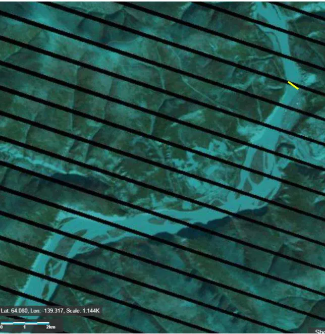
Figure 3: The Yukon River, April 12 2018 (Landsat). The ice cover is light blue.
Dark narrow bands in the river are open water. Because these formed at the
bridge location, indicated with a yellow dotted line (upper right), that bridge
could not be built that winter (2017-2018). ... 6
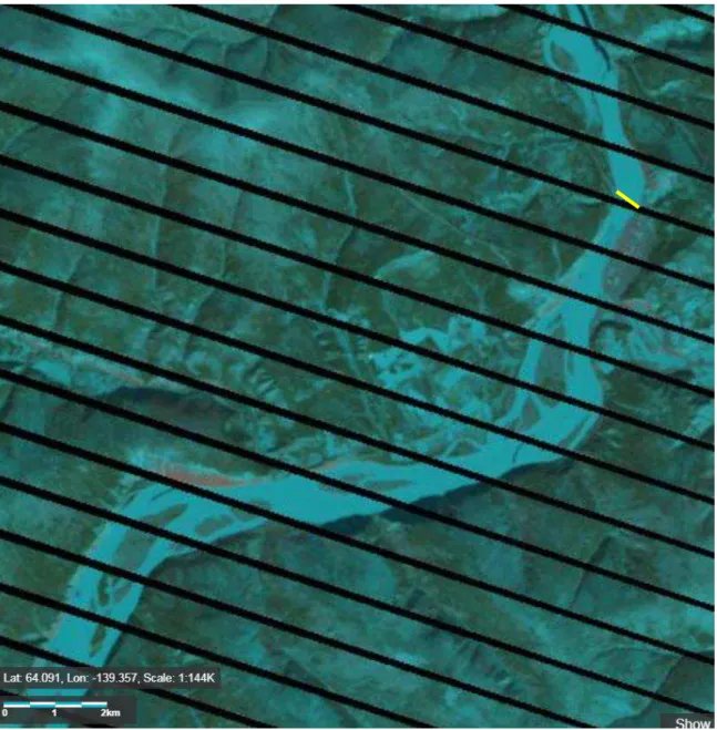
Figure 4: The Yukon River, April 16 2017 (Landsat). Dark narrows bands in the
river are open water. The ice bridge was not built that winter (2016-2017)
–
its usual location is indicated with a yellow dotted line (upper right). ... 7
Figure 5: The Yukon River, March 17 2015 (Landsat). Dark narrows bands in the
river are open water. Bridge location is indicated (upper right). According
to stakeholder consultation, the bridge was operational but required more
work than usual. ... 8
Figure 6: The Yukon River, March 30 2014 (Landsat). Dark narrows bands in the
river are open water. That year, an alternative route (yellow line, upper
right) for the bridge was necessary, because the ice conditions did not allow
it to be built at the usual location [1, 3]. ... 9
Figure 7: The Yukon River, April 2 2013 (Landsat). There are very few signs of
open water. Bridge location is indicated (upper right). ... 10
Figure 8: The Yukon River, April 10 2012 (Landsat). Bridge location is indicated
(upper right). A dark narrow band in the river downstream from the bridge
is an open water lead. The black stripes are due to a sensor failure on the
satellite. ... 11
Figure 9: The Yukon River, March 23 2011 (from USGS LandsatLook). Bridge
location is indicated (upper right). A few open water leads in the river can
be seen on that image. The black stripes are due to a sensor failure on the
satellite. ... 12
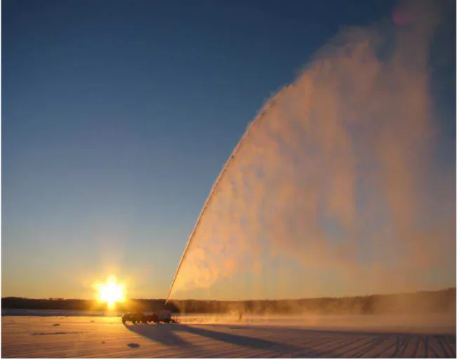
Figure 10: Example of a spray ice operation. ... 13
Figure 11: Spring break-up dates of the Yukon River over the last century, as
reported in a news post - the vertical axis indicates the number of days from
January 1
st. The year 2016 was the lowest on record. ... 15
Figure 12: Examples of border ice (BI) and ice blocks (IB). The red arrow lower
left indicates current direction
– at that location, the current is presumably
strongest, which explains why the river has not frozen at that location.
Brazeau River, Alberta, April 2008. From Wikimedia Commons. ... 21
Figure 13: Ice blocks or
‘hummocky ice’ on the Bow River in Calgary [14]. ... 22
Figure 14: Ice cover evolution of the Yukon River at Dawson City, over the winter
of 2017-2018 (from USGS LandsatLook). Dark narrows bands in the river
is open water. ... 23
Figure 15: Examples of channel bars in vicinity of Dawson, YK. Base image
OCRE-TR-2018-023 vi
Figure 16: Simplified illustration of current behavior as a function of sand bar
extent. The arrows are hypothetical water displacement vectors. The bar in
Case B is significantly larger than that in Case A
– a narrower channel
results in an increase in current velocity. ... 26
Figure 17: Mean temperature increase in the winter [23]. ... 27
Figure 18: Top) Hypothetical system that might help making the ice operation
more secure at the beginning of the winter
– a ground penetrating radar
(GPR) that can be pulled from each side of the river. Bottom) A similar
system with the spray ice unit. Note that, for both deployment system, a line
would first be laid on top of the ice from one shoreline to the other, e.g.
using a helicopter
– this line could then be connected to a proper towing
cable. ... 30
Figure 19: Examples of ice booms used by Ontario Power Generation: Left)
timber; right) steel pontoons. ... 31
Figure 20: Simplified representation of below-ice boom deployment. ... 32
Figure 21: Simplification of a two-step procedure: deployment of a geomembrane
followed by spray ice operation... 34
Figure 22: An amphibious mobile bridge system [32]. ... 35
Figure 23: An alternative option, for a wider river crossing [32]. ... 35
Figure 24: The Yukon River at Dawson City, with approximate effluent discharge
OCRE-TR-2018-023 vii
Table of Tables
Table 1: Strategies to prepare for future river scenarios. ... 38
Table 2 - High level milestones for the construction of the Dawson City ice bridge
for the winter of 2018-2019. ... 41
Table 3: Hydraulic, Hydrologic, and Watershed Data ... 47
Table 4: Satellite and Other Imagery ... 49
Table 5: Water quality ... 52
Table 6: Channel Morphology ... 54
Table 7: Meteorology (within ~50km radius of Dawson, YK) (*: Hourly data not
available for that parameter). ... 55
OCRE-TR-2018-023 viii
OCRE-TR-2018-023 1
1
Introduction
– Background on NRC involvement
The earliest communication between NRC and YG regarding the ice bridges in the Yukon
Territory occurred in early 2015. NRC was then gathering information on winter roads in Canada, to assess the status of that infrastructure and identify outstanding issues impeding these
operations. At that time (winter 2014-2015), the Dawson City operation was performing satisfactorily.
From January to May 2018, several discussions took place between the Yukon Government (YG) and the National Research Council (NRC) about an issue YG currently has with their Dawson City ice bridge. In the last few years, open water in the Yukon River have prevented bridge construction. This occurred in the winters of 2013-14, 2016-17 and 2017-18. In the two most recent cases, the open water channel in the center of the river prevented the construction of an ice bridge, thereby cutting off the link between a small community of about 150-200, herein referred to as ‘West Dawson’, located on the west side of the river and the main section of Dawson City located on the east side of the river. In the winter of 2013-2014, an alternative route for the bridge was necessary, because the ice conditions did not allow it to be built at the usual location [2, 3].
In May 2018, YG invited NRC to investigate why the river is not freezing completely. In the discussions that were held at that time, YG has suggested three possible reasons explaining why the river remains open throughout the winter:
1) warm effluent from a wastewater treatment plant (WWTP) outlet; 2) the existence of a sand bar upstream of the bridge; and
3) an ice jam upstream of the bridge.
Moreover, it was determined that the impact of climate change on the future operation of the ice bridge should also be assessed. YG also asked if NRC could provide some innovative solutions in bridge design, based on an informed understanding of river dynamics.
NRC and YG agreed on a preliminary desktop phase to address these concerns, possibly with an extension afterward into a follow-up phase if/as need be. This report presents the outcome of the preliminary desktop phase, conducted in the summer of 2018. It also includes examples of what could be considered in the follow-up extension later in 2018. This report summarizes NRC’s provisional stance on the Dawson City ice bridge, based on limited information that could be gathered during the preliminary phase. None of its content should be taken as formal endorsement for any particular course of action without further investigation and engagement with all
stakeholders.
1.1 Objectives of this Desktop Study
The objectives of this desktop study are two-fold:
1) To conduct a preliminary desktop assessment of the factors possibly responsible for the river not freezing completely (Section 4).
2) To offer preliminary guidance aimed at making the Dawson City ice bridge operational this winter at the ferry crossing, assuming the river will not freeze completely (Section 5).
1.2 Methodology
In order to assist YG, NRC needed to first acquire a reasonable understanding of the issue. Therefore, in this preliminary phase, the authors brought together currently available information, identified the data that are (or are not) available, and collected historical information on bridge
OCRE-TR-2018-023 2
design/construction (including information on the spray ice operation in the winter of 2017-2018). This work will build on that already done elsewhere [1].
To address this study’s two objectives, two distinct streams were undertaken in parallel:
1) NRC completed a preliminary assessment of the Yukon River’s environmental conditions and relevant anthropogenic effects at Dawson City, to attempt to understand, at least on qualitative grounds and in consultation with stakeholders (e.g. YG, TMB staff,
engineering consultants, City of Dawson, local communities), why the Yukon River remained open in the recent past and may do so again in the future.
2) NRC presented tentative options to prepare for the challenge of building the ice bridge next winter, assuming incomplete freezing of the river. This was done in consultation with stakeholders, including a three-hour community Open House held at the Downtown Hotel in Dawson City on August 22nd 2018.
The outcome of these two streams are presented in this report (Section 4 and Section 5,
respectively). On that basis, recommendations to YG on a way forward are made, including some suggestions in terms of bridge design, planning and construction (Section 6). The assumption will be that, based on recent winters, the Yukon River will not freeze completely next winter (2018-2019) and special measures will likely have to be devised so as to make this operation work. But prior to this, an overview of the Dawson City ice bridge (Section 2) and a brief account of the challenges faced by that bridge (Section 3) are provided.
OCRE-TR-2018-023 3
2 The Dawson City ice bridge
The purpose of this section is to present some background information on the Dawson City ice bridge. The most recent documents on the subject are consultants reports [1-3], one of which includes references to a number of earlier studies [1]. The information in this section was drawn from those reports.
2.1 Ice bridge description
The Dawson City ice bridge is located at the George Black Ferry crossing of the Yukon River – the bridge links West Dawson to the main part of the community east of the river (acting as a replacement to the ferry during the winter). The ice bridge is 400 m in length and its width is about 60 m.
2.2 Ice bridge construction
Once the river has frozen entirely to the required thickness, the snow on the ice cover is cleared with ATVs equipped with a front plow2. Snowmobiles may at times be used either to first flatten
the ice cover when it is too rough or pack the snow to improve trafficability for the ATVs. The ice is allowed to thicken further until a point where light vehicles can start using it. With an increase in ice cover thickness, heavier vehicles and equipment can be hauled onto the ice to flood it so as to keep increasing its thickness. YG reportedly spends about $80,000 each winter to build and maintain the crossing3.
Various provincial and territorial guidelines provide information on bearing capacity [4] – most are based a formula proposed L. Gold’s [5, 6], based on his research at the National Research Council in the 1950’s and 1960’s. The guidelines recommended by [1] are those of the
Government of the NWT [7]. Vehicle weight guidelines are provided in [1, 2]. For instance, an ice thickness of 0.46 m is recommended for vehicle weights up to 10,000 kg; a thickness of 2.18 m is required for loads up to 70,000 kg. For very heavy loads, stress analyses are performed by specialized consultants to determine minimum ice thickness.
2.3 Ice bridge usage
The bridge has been operated since the 1960’s by the Yukon Government (YG). It accommodates light traffic across the river as well as heavy-haul equipment that services the mining industry across the river in the Yukon. West Dawson is also “where the Top of the World Highway begins, linking the Klondike Highway with the Alaska Highway, a popular tourist route in the summer”4.
It is used extensively by snowmobilers.
There is no overlap in time between ice bridge and ferry services. In fact, there are time windows in between these services when neither the ferry nor the ice bridge is in operation, such that river crossing is not available during that transition. The shortest service closures on record (since 1995) in the Fall were 18 days (2005-2006), and 26 days (1999-2000) in the Spring. The longest service closures in the Fall, and 116 days and 99 days in the Spring [1, Table 2.3]. The shortest and longest operational lifespan in any given year are 47 days (2005-2006) and 158 days (2008-2009).
2 Snow acts as an insulator. The purpose of snow clearing is to increase heat exchange between the ice and
the cold air so as to accelerate ice growth.
3 http://www.cbc.ca/news/canada/north/yukon-river-ice-bridge-spray-suspended-1.4500692
OCRE-TR-2018-023 4
Bridge opening dates vary considerably, from early November to early February. Bridge closure is usually between end of March to mid- to end of April. A gradual decrease of the yearly operational lifespan is reported, i.e. 1.75 days/year since 1995 [1](Figure 1).
OCRE-TR-2018-023 5
3 Bridge unable to enter into service
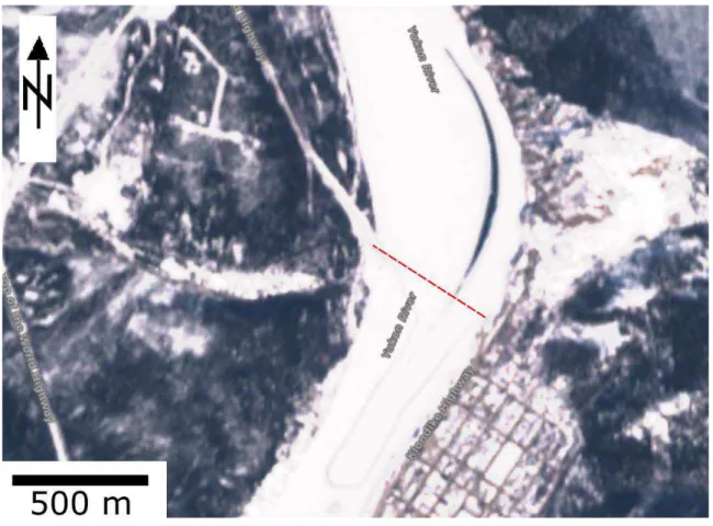
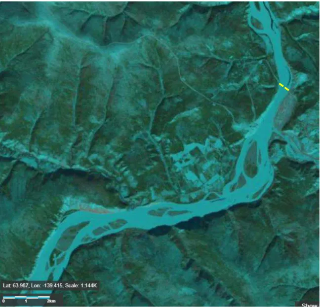
As stated earlier, bridge operations did not run in the winters of 2016-2017 and 2017-2018. In the winter of 2013-2014, an alternative routing was required because the river remained open at the ferry crossing, which is the usual bridge location. Figure 2 is an aerial view of the Yukon River in April 9, 2018 (see also Figure 3). It shows full ice coverage, except for a thin sliver of open water condition at the bridge location that extended downstream from the ferry crossing.
Figure 3 to Figure 9 are examples from a number of previous years.
A number of possibilities were raised by YG and stakeholders as to why the river did not freeze across its full width in these years: a change in flow patterns and current velocity, debris accumulation upstream, an ice jam further upstream, a new sand bar, the effluent of a nearby wastewater treatment plant and a change in climate. The possible impacts of these factors will be discussed in Section 4.
Figure 2: Satellite image of the Yukon River ice cover at Dawson City, April 9 2018 (ESA Sentinel-2).5 River flow is northward. The dashed red line is where the bridge is usually
located – that winter, however, there was no sanctioned ice bridge.
5
OCRE-TR-2018-023 6
Figure 3: The Yukon River, April 12 2018 (Landsat). The ice cover is light blue. Dark narrow bands in the river are open water. Because these formed at the bridge location, indicated with a yellow dotted line (upper right), that bridge could not be built that winter
OCRE-TR-2018-023 7
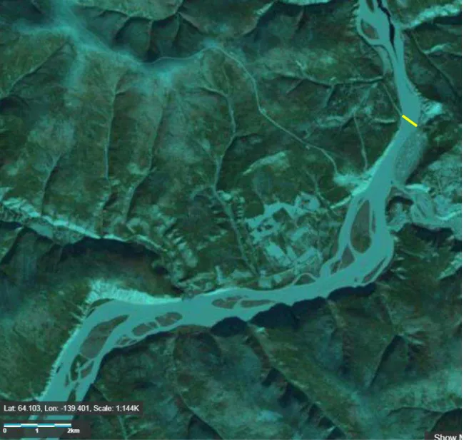
Figure 4: The Yukon River, April 16 2017 (Landsat). Dark narrows bands in the river are open water. The ice bridge was not built that winter (2016-2017) – its usual location is
OCRE-TR-2018-023 8
Figure 5: The Yukon River, March 17 2015 (Landsat). Dark narrows bands in the river are open water. Bridge location is indicated (upper right). According to stakeholder
OCRE-TR-2018-023 9
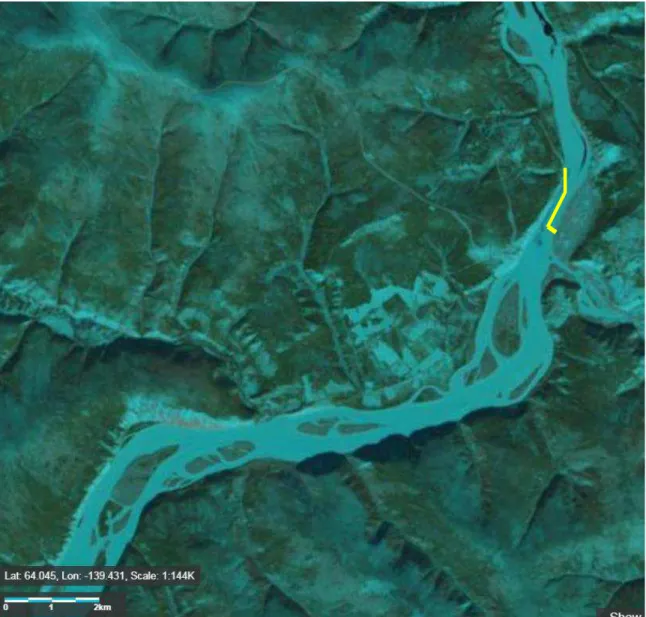
Figure 6: The Yukon River, March 30 2014 (Landsat). Dark narrows bands in the river are open water. That year, an alternative route (yellow line, upper right) for the bridge was necessary, because the ice conditions did not allow it to be built at the usual location [1, 3].
OCRE-TR-2018-023 10
Figure 7: The Yukon River, April 2 2013 (Landsat). There are very few signs of open water. Bridge location is indicated (upper right).
OCRE-TR-2018-023 11
Figure 8: The Yukon River, April 10 2012 (Landsat). Bridge location is indicated (upper right). A dark narrow band in the river downstream from the bridge is an open water lead.
OCRE-TR-2018-023 12
Figure 9: The Yukon River, March 23 2011 (from USGS LandsatLook). Bridge location is indicated (upper right). A few open water leads in the river can be seen on that image. The
OCRE-TR-2018-023 13
3.1 The spray ice operation in 2017-2018
Spray ice is produced by spraying water into the cold air to induce precipitation of ice crystals onto the water surface. This technique has been used extensively (Figure 10)[8-12] and
commercial operations are reportedly using it [1]6. YG hired Tetra Tech over the last few years to
look at the ice bridge [1-3] – that organization has become familiar with it and with the river at that location.
Figure 10: Example of a spray ice operation7.
In late 2017, a decision was made by YG to have Tetra Tech attempt to fill in the open water channel, using spray ice. This operation, which ended up costing $125,0008, only lasted one
week. Factors that played against the operation include:
The contract was set up relatively late (December), giving the consultants little time to plan.
The operation began with a favorable (-15°C to -20°C) air temperature, but it was followed two days later with a warm spell and rain (the consultant relied on 14-day weather forecasts).
The plan was initially for the consultant to out-source the spray operation to a specialist. Instead, they did the work themselves with a spray ice unit they procured from the
6 See also http://bigice.ca/products/ 7 http://bigice.ca/gallery/
OCRE-TR-2018-023 14
Northwest Territories, and used by Yukon’s Transportation Maintenance Branch. That unit was available only for a limited amount of time.
The operation was not backed up with sufficient knowledge of the water temperature and flow behavior at the bridge location. Instead, historical data from a nearby site was relied upon.
An ice boom adapted for that purpose could have been used to retain spray ice that settled on the water surface, but was not – it is conceivable that the a good portion of the spray ice that settled on the water was carried away by the river current.
3.2 Media response
In many cases, where they exist, winter/ice roads are the only supply road to communities during the winter. They are an essential part of the surface transportation network in Canada. When they fail to operate, the communities are significantly impacted. This state of affairs can have negative sociological, economic and psychological implications: the community is unable to bring in their yearly supply of fuel and bulk commodities; access to health and emergency services is reduced or are no longer available; normal social activities, such as family gatherings and sporting events, are hampered. These impacts are often closely monitored and reported by the media. This has been the case for the Dawson City ice bridge. Examples of media report include:
“Dawson City ice bridge across Yukon River now open” 9
This news post, dated January 2016, reports that the community across the river is “no longer cut off” from emergency services because the ice bridge is officially open to traffic. “On thin ice: West Dawsonites wait for an ice road that may not come” 10
According to this news post, dated December 2016, an ice jam is allegedly preventing the river from freezing completely, pointing out to the logistical challenges that entails for the community.
“West Dawson makes do with unofficial ice crossing while Yukon River remains open” 11
This news post, dated February 2017, reports that the usual operation was unfeasible that winter, but an unofficial trail across the river was made for snowmobiles and pedestrians. However, emergency and maintenance vehicles cannot make it across.
“Climate warming leads to changes in river ice across the Yukon Territory” 12
This news post, also dated February 2017, raises the issue of climate change and its likely role in the earliest ever ice river breakup of the Yukon River at Dawson.
“Yukon halts river-freezing experiment at Dawson City” 13
Yukon’s Highway and Public Works Minister explains that “spray technology”, a plan that was announced in late December of 2017 to close the 90-m gap of open water in the Yukon 9http://www.cbc.ca/news/canada/north/dawson-city-ice-bridge-opens-1.3396514?cmp=rss 10 http://yukon-news.com/life/on-thin-ice-west-dawsonites-wait-for-an-ice-road-that-may-not-come/ 11 http://www.cbc.ca/news/canada/north/ice-road-bridge-dawson-city-yukon-river-1.3980576?cmp=rss 12 http://arcticjournal.ca/health-science/science/climate-warming-leads-to-changes-in-river-ice-across-the-yukon-territory/ 13http://www.cbc.ca/news/canada/north/yukon-river-ice-bridge-spray-suspended-1.4500692
OCRE-TR-2018-023 15
River, has not met expectations and the operation was aborted. The bridge would not be available again that year (winter 2017-2018). The post brings out the fact that the operation only lasted a few days when the air temperature happened to be relatively high.
“Climate warming leads to changes in river ice across the Yukon Territory” 14
This article points out to a gradual downward trend in the number of days in the year to river break-up in the spring (Figure 11).
Figure 11: Spring break-up dates of the Yukon River over the last century, as reported in a news post15 - the vertical axis indicates the number of days from January 1st. The year 2016
was the lowest on record.
3.3 Follow-up by the YG
YG mobilized resources and expertise to find out why the river remains open throughout the winter, and most importantly, to see what can be done to have a fully operational ice bridge in following winters. Consultation with NRC was undertaken in that context.
3.4 The August 2018 Dawson City Open House
Engagement with the local community in Dawson City on the ice bridge operation was organized by YG. It took the form of an Open House, which was held on August 22nd 2018, from 1600h to
1900h at the Downtown Hotel in Dawson City. YG invited Paul Barrette, the first author of this report as the NRC representative. Several YG representatives were also in attendance including
14
http://arcticjournal.ca/health-science/science/climate-warming-leads-to-changes-in-river-ice-across-the-yukon-territory/
15
OCRE-TR-2018-023 16
local road foreperson Bruce Taylor, YG engineers Paul Murchison and Brian Crist,
environmental coordinator Erik Pit and communication staff member, Heather McKay. The purpose of this event was to gather feedback from the community – comments, questions, concerns – on the ice bridge operation. About 40 people participated over its 3-hour duration.
3.4.1 Summary of discussions at the Open House
Below is a summary of the Open House’s outcome and the feedback and comments from the individuals who attended.
These minutes were collected by YG and NRC – due to a significant amount of interaction, not all comments could be collected. Note that many of these comments and opinions may not necessarily be aligned with what is happening with the river or reflect the views of all the participants. They are gathered here for information purposes.
They are conveniently grouped into eight themes: 1) General comments, 2) The river bottom, 3) Ice jams and other ice-related issues, 4) How ‘to bridge the gap’ between the shores – Booms, 5) Alternate routes, 6) Operational aspects, 7) Safety, and 8) Moving forward.
3.4.1.1 General comments
There has been a drastic increase in the population of West Dawson in recent years. The Klondike is not ‘behaving’ as it has in the past. Why is that?
The open water lead is getting “bigger and longer”.
Three winters ago, the ice bridge building operation worked, but required a lot more effort to build a workable ice bridge.
One conceivable sequence of causes: Low water levels (e.g. if river freezes later) lead to an increase in amount of silt which lead to ice jamming upstream of junction.
The Klondike River is also not ‘behaving’ either – sometimes people cross in the morning but cannot get back later in the day.
A river glacier upstream is outputting less water than usual. Could this not affect river flow at Dawson City?
Thought that the hydro dam near Whitehorse could play a role? It is a long way up in the watershed.
This could be checked by comparing historical records of water levels at Dawson and dam operations.
Some expressed belief that there has been more wind from the north. Could this promote sublimation?
3.4.1.2 The river bottom
The current in the Yukon River has become faster because of a sand bar at the Klondike junction.
Dredging (to remove this bar or reduce its size) is deemed good option (suggested by several people).
Work was done on the river bed next to the east shoreline about 30 years ago which included construction of new berms.
Could this be affecting river behaviour today?
Several years ago, a small island upstream the Klondike River was washed away and deposited at the junction of the Klondike and Yukon Rivers.
OCRE-TR-2018-023 17
3.4.1.3 Ice jams and other ice-related issues
When ice jams occur, they are usually in front of town; if they don’t occur, there is an open water lead.
Several ‘jam points’ in river flow were reported: 1) at the junction of the Klondike and Yukon Rivers, 2) further upstream, and 3) downstream from current ferry crossing. Since river freezing occurs later, because of water levels are getting progressively lower,
ice jams typically occur further upstream.
Paul B. (from NRC) asked what people thought about what a safe ice thickness is. Replies:
No blanket answers. Charts provide that information. It depends on the vehicle’s weight and configuration (from YG).
Jurisdictions across Canada normally have their guidelines.
Paul B. asked whether people are aware of the existence of ‘wet cracks’ (These are cracks that span the full ice thickness.)
Because of them, water makes its way to the surface (hence the word ‘wet’). People are not aware of this being an issue – there are lots of cracks, but they are
dry (surface cracks that don’t penetrate down to the water).
3.4.1.4 How ‘to bridge the gap’ between the shores - Booms
Boom option could work but anchoring would need to be strong enough (nets across the river could also work).
Navigation hasard, possible environnemental objections. Two boom deployment options were discussed:
Placing booms in open water before freeze-up. Placing booms on the ice surface.
Preference for the latter option was expressed.
Use of natural rope was suggested (i.e. biodegradable) to span the open water lead, along with willows and alders, to offer support for ice to form – these would also provide structural integrity.
A suggestion was made to allow ice to grow around a series of floating wood boards laid on the water surface, then extend the procedure progressively toward the center of the river.
Flood risk: What about the chances of a boom inducing flooding, or otherwise affecting river break-up?
The bridge never did promote jams, so why would a boom? To have a jam, the full water column has to be blocked by ice.
Because flooding could have severe consequences, the potential impact of booms on water levels should be investigated.
As an experiment, wood chips were once dropped into the water, promoting ice formation.
Because it contains no bark (whose high acidity is objectionable), it would be environmentally acceptable, i.e. no objections should be expected from DFO. The long-term weather forecast is often inaccurate – this was a problem last year when
YG used spray technology and could be a problem again in the future. Temporary (floatable) bridges – Could this be a viable option?
3.4.1.5 Alternate routes
The usual location is ideal; close to it is the second best option; away from it is better than nothing.
OCRE-TR-2018-023 18
Paul B. asked how important is the length of the road? It depends where you live on the west side.
Current location (at the ferry crossing) favors West Dawsonites. The longer the route, the trickier it is for big rigs.
Why is the long alternate route option being considered this year but not considered last year?
Last year, the freeze-up looked very promising in the fall.
Also, it crosses various jurisdictions, and it takes time to go through all the permitting procedures.
YG would discuss potential alternate route with affected landowners.
Why not just use the ice that already exists in the river (instead of making it artificially)? Wait to see the state of the ice coverage, then plan route accordingly (adaptive
planning).
Could potentially use the grounded shore ice, along the east shoreline.
Shore ice is unsafe – it tends to collapse and may not be able to support heavy vehicles.
Concerns were expressed about falling rocks.
The Sunnydale loop is not suitable for big rigs – it is too long and too hard to maintain. The ‘unofficial’ road.
It is maintained mostly by western residents.
There are no historical records of how it performed over the years. Apparently, it once accommodated passage of a 10-ton vehicle.
3.4.1.6 Operational aspects
There is not much awareness about how vehicles affect the “unofficial” bridges. Example: A snowcat is heavy but the load is distributed, such that very low
vertical stress are exerted onto the ice, i.e. the ice is able to support that weight. However, a common misconception is to assume lighter vehicles can make it if
the snowcat can. What people are not aware of is that though the vehicle is lighter, its small footprint exerts higher stresses on the ice.
Paul B. asked whether the speed of vehicles have an impact? Waves can be felt on ice as a vehicle goes by.
Speeding is a concern to the community, more in terms of traffic safety than load bearing capacity.
Paul B. asked whether snow an issue?
Not really – snow storm are not common.
However, significant snow accumulation can happen because of drifting snow, especially at some locations.
3.4.1.7 Safety
Paul B. asked - NRC and YG value health and safety – what is everyone’s view on this? What kind of control, measures, monitoring are implemented to mitigate risks of
accidents?
Occupational health and safety guidelines were raised in the discussions. Crossing the “unofficial” bridge in the last 3 years has been “nerve wrecking”, according
to a witness, because ice is unpredictable; one would rather not cross, especially with children.
OCRE-TR-2018-023 19
3.4.1.8 Moving forward
YG should get prepared ahead of time, as opposed to doing things last minute.
It was stated in that some operations, such as last winter’s spray ice, should be non-stop, i.e. around the clock. In order to do that, floods lights are needed (Occupational health and safety requirements).
These should be available in Dawson as needed. YG should inform people on the Open House’s outcome.
All should have access to NRC’s report, which will contain discussions on these options.
A participant indicated that permitting (“red tape”) may delay implementation of a practical solution.
This year, YG is being pro-active, which is good.
When will a plan be decided upon? Will we be informed?
YG staff said they are currently discussing options– no set date yet.
Make decisions when opportunities present themselves, and don’t get stuck to a target date to make decisions.
Is there a budget available to do the work? YG staff said there is.
3.4.2 NRC’s position with respect to the Open House
From NRC’s perspective, the outcome of the community engagement is considered anecdotal evidence, i.e. it is a form of data. Although such information needs to be assessed from a holistic perspective, it can provide very useful guidelines in evaluating follow up options. In the report’s following sections, NRC will address the report’s two objectives: 1) Understanding the Yukon River (Section 4), and 2) Conceivable options for a successful ice bridge at the ferry crossing (Section 5). It should be mentioned that several of the items raised during the Open House had already been captured by NRC (through stakeholder consultation pre-dating the Open House). That overlap is desirable, as it indicates a consistency in stakeholder viewpoints between different groups of stakeholders.
OCRE-TR-2018-023 20
4 Understanding the Yukon River
A practical understanding of the Yukon River and of the parameters that affects its behavior is a prerequisite to providing guidance for future ice bridge operations, so as to try to identify the source of the problem. A preliminary review is provided in this section.
4.1 Data sources
As part of this study, NRC compiled a listing of the parameters of interest, related to hydrology, hydraulics, meteorology, river morphology (e.g. bathymetry) and ice regime. NRC also compiled a listing of factors stemming from human activities, which may explain a lack of river icing at the crossing. Tables are provided at the end of this report and summarize these listings, sorted into three classes of data:
‘Type A’: Data that can be obtained in the short term, i.e. within the project lifespan ‘Type B’: Data that are not readily available, but could be obtained after the project
lifespan
‘Type C’: Data that do not exist but could be generated in the future
These sources are included in this report for the purpose of awareness. The information they contain has yet to be assessed.
4.2 Ice river dynamics
Ice river dynamics have been studied by many investigators. There are good overviews on it, including theoretical treatments, numerical modeling and reference to the influence of climate change [13-18]. The information most relevant to this study relates to river freeze-up processes, namely the evolution of the ice cover in the fall and winter. The river-ice dynamics (including ice growth, thickening and jamming) will determine the state of the ice cover on which the ice bridge will be constructed.
4.2.1 Ice growth
Ice growth in rivers is considerably different from that in lakes. The primary difference is the presence of currents. Depending on river width, channel configuration and water regime, currents can be significant at some locations, while minimal in others. Currents impact ice growth by preventing the accumulation of ice crystals at the surface, either by mechanical or thermal means. Currents can also have an erosional effect on the bottom of the ice that has already formed.
The first requirement for ice growth is a decrease in water temperature during the Fall and into the Winter. Snow fall can also initiate river freezing. Ice growth from the shoreline, especially in shallow, relatively calm waters (flow velocity less than 0.1 m/sec), may begin the freezing cycle. This ice is called ‘border ice’ or ‘shorefast ice’ (Figure 12). In more turbulent river sections, small ice crystals (known as ‘frazil’) can accumulate and produce ‘flocs’ that drift and eventually form ice ‘floes’ known as ‘pancake ice’. These may collect along the border ice or achieve
progressively higher surface concentrations until a continuous or near-continuous ice cover is formed.
The growth of ice on a river surface may be prevented by current action. Even with very low air temperatures, water currents can do two things: 1) they can raise warmer water to the surface through turbulence, preventing an ice cover from forming; 2) they can bring ice particles (frazil, snow) down in the water column where they will melt because the water is warmer (further from the water-air boundary).
OCRE-TR-2018-023 21
Figure 12: Examples of border ice (BI) and ice blocks (IB). The red arrow lower left indicates current direction – at that location, the current is presumably strongest, which explains why the river has not frozen at that location. Brazeau River, Alberta, April 2008.
From Wikimedia Commons16.
4.2.2 Ice thickening and ice jams
Thickening of the ice cover may occur in various ways. One is downward growth (accumulation on the underside of the ice cover) – this leads to what is known as ‘black ice’. Another is when water manages to find its way to the surface of the ice cover, either from below, or flooding through other sources. If there is a snow layer present during flooding, it will become saturated with flood water. This leads to the formation of ‘white ice’, which has a lower density and is mechanically weaker than the underlying black ice [19]. Yet another ice cover thickening mode is through ‘hydraulic thickening’, when drifting ice pieces are pushed against each other and begin to overlap. These may occasionally develop into fields of ice blocks or hummocky ice (Figure 13).
OCRE-TR-2018-023 22
Figure 13: Ice blocks or ‘hummocky ice’ on the Bow River in Calgary [14]. Thickening of the ice cover may be such that it induces what is known as a ‘freeze-up ice jam’ because what was originally flowing has become frozen into a stable surface. Pieces of ice which could contribute to ice bridge initiation are prevented by the jam from drifting further
downstream. Lower water levels will promote grounding. ‘Break-up ice jams’ are also well documented in rivers, but they are not relevant to this report, as they occur in the spring, when the ice bridge is no longer in operation.
4.2.3 Open water
Rivers do not always freeze over entirely during any given winter. The amount of freezing depends on a number of parameters, namely current speed, as can be seen in Figure 12. Average air and water temperatures over the winter do matter as well.
A review of satellite imagery (Figure 3 to Figure 9) indicates that localized open water conditions have occurred at various sites along the Yukon River over the last number of years, as indicated in several figures, even the years when the bridge was operational.
4.2.4 The Yukon River at Dawson City
As of this writing, no field photography was obtained that would allow detailed interpretation of ice formation processes in the Yukon River. However, the satellite imagery in Figure 14 does provide an indication of river freeze-up evolution. In order to confirm these observations, one would require better visual information on the ground, as well as flow data across the river width, depth and locations. A proper understanding of the ice regime at and near the bridge location, preferably a historical record, would prove highly beneficial.
OCRE-TR-2018-023 23
Figure 14: Ice cover evolution of the Yukon River at Dawson City, over the winter of 2017-2018 (from USGS LandsatLook). Dark narrows bands in the river is open water.
4.3 River morphology and hydraulics
A brief overview is provided in this section on this topic, and more background information can be found in Appendix A.
4.3.1 Why river bathymetry can be in constant evolution
Water flowing in open channels, such as the Yukon and the Klondike Rivers, are subject to two principal forces: gravity and friction. Gravitational forces drive the downstream motion of the
OCRE-TR-2018-023 24
flow along the slope of the channel, whereas friction resists the downslope motion of the flow [20-22].
In a natural river with an alluvial bed (i.e. mobile sediments, typically sand and gravel), such as the Yukon River, a complex feedback relationship exists between flow hydraulics, channel geometry and sediment transport. Frictional forces exerted by the flow can mobilize and transport sediment, thereby reshaping the channel geometry. Hence, adjustments in geometry can influence the flow. Natural channels never truly achieve a state of static equilibrium (no or nearly no erosion of the riverbed) because, in addition to other contributing factors, upstream flow and sediment inputs vary in time. In other words, natural rivers are constantly evolving, and the nature of that evolution depends on a number of parameters, namely: flow, sediment supply and channel slope.
However, over time, natural channels will adjust toward an equilibrium state by altering their channel geometry. For this reason, natural alluvial channels rarely have a straight course and a flat bed. Instead, they display a degree of meandering across the land and features on the riverbed known as ‘bedforms’. Some common bedforms include bars, ripples, dunes, and antidunes. Bars may be further categorized as follows:
Point bars: form on the inner bank of meanders
Alternate bars: distributed periodically along one and then the other bank of the channel Channel junction bars: form at the confluence of a tributary and the main channel Transverse bars: form diagonally to the flow (i.e. riffles)
Mid-channel bars: commonly form in braided and anastomosing rivers with abundant sediment supply
4.3.2 Relevance to the Yukon River at Dawson City
The sediment deposit located at the confluence of the Klondike River and the Yukon River near Dawson is characteristic of a channel junction bar and many mid-channel bars can be observed on the Yukon River upstream of Dawson (Figure 15). The channel junction bar needs to be
investigated to see if it has grown in recent years. If so, further investigation may be required to characterize the growth and to assess the impact on the river flow. Characteristic of channel junction bars, the bar development is related to the sediment influx from the entering tributary (i.e. the Klondike River). Has sediment influx from the Klondike River increased significantly in recent years? Are there any human activities upstream which could have caused such an increase?
The consequences of increased sediment influx and changes to bedforms are not trivial. The bar exerts a direct influence on current behavior, i.e. a large bar may constrict flow and intensify current velocity in the vicinity of Dawson (Figure 16), which would adversely affect ice cover growth.
OCRE-TR-2018-023 25
Figure 15:
Examples of channel bars in vicinity of Dawson, YK. Base image obtained
from Google Earth.
OCRE-TR-2018-023 26
Figure 16: Simplified illustration of current behavior as a function of sand bar extent. The arrows are hypothetical water displacement vectors. The bar in Case B is significantly larger than that in Case A – a narrower channel results in an increase in current velocity.
4.4 Global warming and Climate change
According the USGS17, ‘Global warming’ alludes to a general albeit very slight (a few degrees)
increase of the Earth atmosphere’s average temperature to result from greenhouse gas (GHG) emissions. ‘Climate change’ is the “increasing changes in the measures of climate over a long period of time”. It is important to realize that phenomena related with climate change not only include global and regional temperatures but also variables such as precipitation, evaporation, wind patterns, permafrost, wet and dry spells, snowpack and, ultimately, river flow regimes. Appendix B provides additional background information in that regard.
4.4.1 Relevance to the Yukon River
Some climate models predict a substantial temperature increase in Northern Canada (Figure 17). There is little doubt climate change could also be a contributing factor for the Yukon River problem. To determine unequivocally if its impact is real and significant, or to see if there has been an alteration in the river’s natural behavior regardless of climate change, a careful analysis of the available information (river flow, bathymetry, river ice dynamics, air temperature, precipitation, etc.) would be required.
17
OCRE-TR-2018-023 27
Figure 17: Mean temperature increase in the winter [23].
4.4.2 Prospective investigation avenues
Concerning the effects of climate change, a number of investigation avenues may be considered. The presence of an open water lead may have been the result of warmer than usual winter temperatures in air and water (and even shoreline ground). Consequently, it is important to study local and regional temperature patterns and their projected future evolution in order to understand the severity and frequency of such events.
Along with temperature-related investigations, it is also important to study how the characteristics of rain-on-snow events have evolved over the historical period and how such events will be impacted by climate change. Increased frequency of such events during the winter period can cause rapid melting of snowpack and warmer water temperatures. For this study, a physically-based regional climate modeling exercise can be conducted to produce an ensemble of present day and future simulations. Physically-based Regional Climate Models (RCMs) – see Appendix B – are suitable for such investigations. Data analyses can be conducted following [24] and can be supported further by an independent investigation based on climate change simulations available through CORDEX (https://na-cordex.org/). A regional analysis of changes in snowpack characteristics would be helpful.
OCRE-TR-2018-023 28
An analysis of local and regional winter low flows would be helpful in understanding if a change in low flow regimes is a causative factor. During low flow periods, rivers draw water from soil water stores (groundwater). If winter low flow levels are increasing, then that will be an indication that warmer water released from soil stores is a contributing factor. Noting that the Yukon River cuts through different permafrost zones, it would be informative to evaluate how low flow regimes and permafrost will change in the future. Some preliminary conclusions can be drawn from previously published studies [e.g. 25, 26] and territorial government documents.
OCRE-TR-2018-023 29
5 Options for a successful ice bridge at the ferry crossing
Notwithstanding the proposed investigations discussed in Section 4 to identify the source of the problem (as to why the river has not been freezing entirely at the ferry crossing in the last few years), YG must ensure there is a fully operational ice bridge next winter and in subsequent winters.
The Dawson City ice bridge has historically been a relatively successful operation. But these new circumstances – i.e. the existence of an open water lead – call for new or novel procedures and techniques. The conventional bridge building methods may no longer be sufficient. This section will address the report’s second objective, which is to examine options for constructing and maintaining the ice bridge at the ferry crossing, assuming the worst case scenario, i.e. there will be a central channel of open water all along the river between Dawson City and West Dawson.
5.1 Safely assessing the ice cover
Safety is paramount – this has to be kept in mind from the start. A robust health and safety plan has to be implemented before the beginning of any on-ice operation. Such a plan should take into account all threats (breakthroughs and others), and have to be mitigated well ahead of time through consultation with all relevant authorities. Details on safety procedures are provided in [2] for the Dawson City ice bridge operation. These procedures could be used as a starting point and adapted as required in moving forward with ice bridge construction and operation.
Since ice cover breakthrough is the most serious threat, it is important to avoid working on the ice until it is deemed thick enough to support whatever load one needs to bring on it. This is a
universal challenge with ice roads and bridges wherever they are used, because to check ice thickness accurately, one needs to step on it. Compounded to this challenge is the fact the water is moving – the current at the ferry crossing is about 1.5 m/s (Table 3.2 in [1]). Although operator experience and adequate guidance from engineering consultants alleviate these risks, accidents can and do happen.
5.1.1 A safer means of monitoring ice thickness
One possibility would be to extend a light cable across the width of the river, i.e. from one shoreline to the other, so as to be able to tow a ground penetrating radar (GPR) on a small floatable craft across (Figure 18, top diagram), back and forth as required. This assumes the ice cover is complete – see later for discussions on cable deployment and options as to how to close up open water areas.
The GPR is a standard tool to measure ice thickness, but it needs to be validated against auger holes. NRC is currently investigating the deployment of an unmanned, GPR-fitted remotely controlled hovercraft, fitted with an auger and other instrumentation. The Dawson City ice bridge would be an example of an operation that would benefit from the data gathered by that tool. Technology development, however, is still in the early planning stage.
OCRE-TR-2018-023 30
Figure 18: Top) Hypothetical system that might help making the ice operation more secure at the beginning of the winter – a ground penetrating radar (GPR) that can be pulled from each side of the river. Bottom) A similar system with the spray ice unit. Note that, for both
deployment system, a line would first be laid on top of the ice from one shoreline to the other, e.g. using a helicopter – this line could then be connected to a proper towing cable.
5.2 Ice booms
An ice boom typically comprises a floating line of cable and pontoons at regular intervals that spans the river in order to accumulate ice on the upstream side. An ice boom is commonly used to assist in the formation of a stable ice cover during the winter months [27-30], by bringing
together the drifting ice to allow it to freeze into an ice sheet. They are typically made from timbers or steel pontoons joined with a cable and anchored to the shoreline or to riverbed anchor (Figure 19).The length, size and type of floating elements, retention capacity (i.e. kN/m) are amongst the factors that need to be considered.
5.2.1 Relevance
The use of an ice boom on the Yukon River has already been suggested by Tetra Tech [1]. Ice booms can be deployed late in the fall so as not to interfere with normal usage of the waterway and are removed in the spring. They are known to have “a negligible effect on the natural hydraulic conditions in the river, have little influence on [river bed dynamics, and do not impede fish migration” [27, p. 53].
5.2.2 Options for boom deployment
The following are some prospective options for deployment of ice booms on the Yukon River.
5.2.2.1 Open water
Open water deployment is the most commonly used approach in other rivers. It is scheduled when navigation activities have ceased and before the river begins to freeze. Removal is done in the spring, when the ice has thawed completely. Note that open water boom deployment would be a
OCRE-TR-2018-023 31
preventive, pro-active measure, in the sense that it would be implemented even if the river ends up freezing entirely (no open water).
Figure 19: Examples of ice booms used by Ontario Power Generation: Left) timber; right) steel pontoons.18
5.2.2.2 Below-ice installation
This option, summarized in Figure 20, assumes there will have been a cable installed in open water from one shoreline to the other at the bridge location. As is the case for the open water installation, below-ice installation is a contingency measure. If the river happens to freeze entirely that winter, that cable will not be needed – it can remain on the riverbed. However, if there is strong suspicion an open channel will remain, then it can be dislodged from the ice at both ends and used to pull a boom from below the ice.
5.2.2.3 Sink-and-float approach
With this option, a brief account of which is presented in [30], the pontoons making up the boom are lying on the riverbed in the summer with the individual pontoon filled in with water. They are allowed to float up in the fall by inflating the pontoons with air, and filling them with water again in the spring to allow them to sink back to the river bed. This procedure is a more elaborate version of the preceding below-ice option, the advantages and disadvantages of which would have to be carefully considered.
OCRE-TR-2018-023 32
OCRE-TR-2018-023 33
5.2.2.4 Over-ice installation
This option is similar to the sink-and-float approach, except that deployment occurs from above the ice. It has the advantage that the ice boom will not freeze into to ice at the two shorelines, since it does not lie on the seabed. The challenge may be deployment from one shore to the other – it could hypothetically be done with a helicopter, as mentioned earlier. The end result would be similar to what is shown with the GPR, but where a cable would be used to bring the boom to the open water channel (Figure 15, bottom diagram). Once in place, the ice boom would be expected to freeze into the ice, and be retrieved after the spring thaw.
5.3 Spray ice
The success of a spray ice operation would be optimized if certain conditions are met, namely: 1. Air and water temperatures are low enough at the location of interest.
2. The water cannon is powerful enough to reach the entire width of the open water channel from ice that is thick enough to support the spray ice unit.
3. A boom is set up to capture the ice (unless it can be shown that the current is not strong enough to remove the ice as it settles on the water surface).
4. Appropriate time is allowed to prepare, deploy and operate the unit. 5. A robust safety plan is available for approval by government officials.
Point (2) above assumes the spray ice unit will operate from the east shoreline, since the other shoreline will not be accessible. Also, if the border ice is not thick enough, it will have to operate from the land, i.e. the water cannon may need to spray water at a distance of 250 m or more. This would present a challenge operationally, and also with regards to safety – the thickness of an ice cover on a partly frozen river has to be carefully considered.
One way this could be dealt with is by housing a spray ice unit on-board a small floatable craft. Assuming a cable is available between the two shorelines (as discussed in section 5.1 with the GPR), and a boom is in place (Section 5.2), the craft may be mobilized as required. Once a uniform surface is achieved, the GPR can be substituted for the spray ice unit in the same craft.
5.4 Ice reinforcement
The ability for an ice cover to withstand a load can be increased by artificially increasing its thickness through flooding or spraying operations. This can be done by flooding the ice surface with pumps that draw water from a hole in the ice. Spray ice is another possibility. A very different alternative is to reinforce the ice cover with a structural material, either organic (trees, branches, wood,… as was pointed out in the Open House), or with an artificial material (e.g. a geomembrane).
Ice reinforcement has been shown to work, but only at a small scale. The only material used fairly systematically for that purpose were trees in remote areas where there is an abundant supply of them. The National Research Council is beginning a three-year test program to identify and test an appropriate membrane incorporated into the ice, which would fulfill that role. This will be done in the laboratory – if proven feasible, it will be extended to a target field location for further validation.
Although this option is entirely hypothetical as of this writing, it could conceivably be applied in the future to an operation such as the Dawson City ice bridge. The principle is illustrated in Figure 21. The first step would be to deploy the geomembrane over the open water lead. The second step would be to pull a spray ice unit next to the geomembrane. That system would have a dual purpose:
![Figure 1: Number of days the ice bridge was open from 1995 to 2016 (from [1]).](https://thumb-eu.123doks.com/thumbv2/123doknet/14037496.458690/17.918.155.798.225.560/figure-number-days-ice-bridge-open.webp)