HAL Id: lirmm-00192602
https://hal-lirmm.ccsd.cnrs.fr/lirmm-00192602
Submitted on 28 Nov 2007
HAL is a multi-disciplinary open access
archive for the deposit and dissemination of
sci-entific research documents, whether they are
pub-lished or not. The documents may come from
teaching and research institutions in France or
abroad, or from public or private research centers.
L’archive ouverte pluridisciplinaire HAL, est
destinée au dépôt et à la diffusion de documents
scientifiques de niveau recherche, publiés ou non,
émanant des établissements d’enseignement et de
recherche français ou étrangers, des laboratoires
publics ou privés.
An Efficient Data-hiding Method Based on Lossless
JPEG2000 for a Scalable and Synchronized Visualization
of 3D Terrains
Khizar Hayat, William Puech, Gilles Gesquière
To cite this version:
Khizar Hayat, William Puech, Gilles Gesquière. An Efficient Data-hiding Method Based on Lossless
JPEG2000 for a Scalable and Synchronized Visualization of 3D Terrains. EUSIPCO: EUropean SIgnal
Processing COnference, Sep 2007, Poznan, Poland. pp.2519-2523. �lirmm-00192602�
AN EFFICIENT DATA-HIDING METHOD BASED ON LOSSLESS JPEG2000 FOR A
SCALABLE AND SYNCHRONIZED VISUALIZATION OF 3D TERRAINS
K. Hayat
a, W. Puech
aand G. Gesquiere
baLIRMM Laboratory, UMR CNRS 5506, University of Montpellier II
161, rue Ada, 34392 MONTPELLIER CEDEX 05, FRANCE
bLSIS Laboratory, UMR CNRS 6168, Aix-Marseille University
IUT, rue R. Follereau, 13200 ARLES, FRANCE
[email protected], [email protected], [email protected]
ABSTRACT
Real-time on-line 3D visualization of terrain is a memory intensive process accompanied by considerably large data transfer across the network and thus data compression is in-evitable. The upcoming standard of JPEG2000 is well suited for such network based transfers since it offers the additional advantage of resolution scalability resulting in incremental improvement of quality. The 3D visualization process is, es-sentially, the linking of the texture image with the terrain ge-ometry obtained from DEM; the data are heterogeneous and normally involves more than one file. This work is concerned with the interleaving of these files into one jp2 file in a syn-chronized way so that the file format is conserved for com-pliance to the JPEG2000 standard. This synchronization is achieved by using a scalable data hiding method to embed the lossless wavelet transformed DEM in the corresponding lossless JPEG2000 coded texture. For the DEM and the tex-ture, the level of transform is the same. With this approach the 3D visualization is efficient even if a small fraction of the initial data is transmitted.
1. INTRODUCTION
With the incredible technological advancement of the past few years, both the spatial and temporal requirements of the 3D terrain visualization have grown considerably. Process-ing powers and memory sizes as well as network speeds and bandwidths have also increased considerably. But at the same time the users are becoming more and more demand-ing in terms of visualization quality. It is currently possible to have aerial/satellite images with an accuracy as high as 0.50 meter per pixel, and even more, but with a storage cost. The problem is exacerbated when it comes to real-time visualiza-tion where the data have to be transferred from a server to a client application. The diversity of clients in terms of net-work, computation and memory resources add another facet to the problem, since a client may, for instance, have lower capacity of handling the real-time data and it would have to receive a coarser data. The last problem but not the least is the increased demand for higher accuracy that implies a finer resolution. All these factors necessitate the setting up of some strategy based on a multi-resolution approach. The up-coming standard of JPEG2000 [3] serves this purpose since it is wavelet based which offers the property of resolution scalability that is most suited to the solution of our problem. As far as the visualization in three dimensions is con-cerned, it is important to link the images of the terrain, called textures, with the geometry of the terrain computed with the digital elevation model (DEM). This linking is possible by
geo-referencing the coordinates (longitude/latitude) of these elements and define the scale and the projection system used. All these informations are in general stored in three different files: DEM, texture and system of geo-referencing employed. One would be better off if these files are combined into a sin-gle one. There are solutions like GeoJP2 [2] and GMLJP2 [8] but these serve the purpose partially since the data is not syn-chronized and there is an increase in the original size of the jp2 file. We follow a different course, to have the advantage of synchronization without any change in the jp2 file size, by applying a scalable data hiding algorithm. Neither our ap-proach is XML based, like GMLJP2, nor do we introduce some kind of UUID boxes, like GeoJP2.
We intend to visualize, on a client application, a terrain defined by the given elevations and their corresponding tex-ture whereby the data is stored on a distant server and is sent in small-sized packets in order to minimize the waiting time. Our objective is to store and synchronize all of this infor-mation in only one file in order to develop a client-server application for 3D real-time visualization. The approach is to utilize discrete wavelet transformation (DWT) to decom-pose the 3D information at various resolution levels and to embed the resulting data in the related image which is it-self decomposed at different resolution levels. From this ap-proach it is possible to transmit only one file containing all the information and at the reception only a fraction of the data should be sufficient for an optimal or near-optimal vi-sualization. In order to store all the information in a sin-gle file, without developing any new proprietary format and maintaining compressions performances, we propose in this paper the use of a JPEG2000 based embedding method for data hiding. The peculiarity of our method is the synchro-nization achieved by dynamically linking the wavelet trans-formed DEM with the corresponding wavelet transtrans-formed aerial image keeping in view the resolution scalability char-acteristic of the JPEG2000 format.
2. PREVIOUS WORK
There are already efforts like GeoJP2 and GMLJP2 for the integration of geographical data with the related aerial pho-tographs. The GeoJP2 is a GeoTIFF-based method for adding geospatial meta-data to a JPEG2000 file. The addi-tions made to the box-based jp2 format are two UUID boxes, namely, the GeoTIFF box and the optional world file box. The former contains a degenerate GeoTIFF file and the re-sultant jp2 file have the same level of geospatial meta-data as is provided by the GeoTIFF standard [2]. The mechanism is simple using the widely supported GeoTIFF
implementa-tions but the introduction of new UUID boxes have the disad-vantage that there is an increase in the original jp2 file size. The GMLJP2 envisages the use of the Geography Markup Language (GML) within the XML boxes of the JPEG 2000 data format in the context of geographic imagery. In [8], a minimally required GML definition is specified for geo-referencing images while also giving guidelines for encoding of meta-data, features, annotations, styles, coordinate ref-erence systems, and units of measure as well as packaging mechanisms for both single and multiple geographic images. Digital Elevation Models are treated the same way as other image use cases whereas coordinate reference system defi-nitions are employed using a dictionary file. Thus DEM is either provided as TIFF file and it’s name is inserted between proper GML tags or its points are directly inserted into the GMLJP2 file. In the former case there is no reduction in the number of files whereas in the latter case the amount of data is increased.
Many methods have been proposed in the literature for wavelet-based data hiding but few of these are compatible with the JPEG2000 scheme. According to Meerwald and Uhl [12], data hiding methods for JPEG2000 images must process the code blocks independently and that is why meth-ods like inter-subband embedding [5] and those based on hierarchical multi-resolution relationship [7] have not been recommended. In the same breath he rejects the correlation-based method [15] as well as non-blind methods for the rea-son of limited number of coefficients in a JPEG2000 code-block that are likely to fail in reliably detecting the hidden information in a single independent block. There are meth-ods [16, 6] of embedding invisible watermarks by adding pseudo-random codes to large coefficients of the high and middle frequency bands of DWT but these methods have the disadvantage of being non-blind. The blind scheme proposed in [14] is to integrate data hiding with the EBCOT (Embed-ded Block Coding with Optimized Truncation) and embed data during the formation of compressed bit stream. The scheme is claimed to have robustness and good perceptual transparency. One particular technique [11] embed water-mark in the JPEG2000 pipeline after the stages of quantiza-tion and ROI scaling but before the entropy coding. For re-liability purposes the finest resolution subbands are avoided. A window sliding approach is adopted for embedding with the lowest frequencies having higher payload. Piva et al. [13] has proposed the embedding of image digest in a DWT based authentication scheme where the date is inserted in the layers containing the meta-data. One blind method [9] transforms the original image X by one-level wavelet transform and sets the three higher subbands to zero before inverse transform-ing it to get the reference image Y. The difference values be-tween X and Y are used to ascertain the potential embedding locations of which a subset is selected randomly for embed-ding. The method of Kong et al. [4] embeds watermark in the weighted mean of the wavelets blocks, rather than in the in-dividual coefficient, to make it robust and perceptually trans-parent.
3. THE METHOD
The data are generally stored in three different files: the DEM, the texture and the coordinate and projection system employed. In order to store all of these informations in a sin-gle file we propose in this paper to embed the DEM in the
texture in a synchronized and scalable way. An information of altitude is thus synchronized with the corresponding pixel block of the texture. We choose to use JPEG2000 format in order to fully exploit the property of multilevel resolution for scalability purposes. The implementation of the discrete wavelet transformation (DWT) of the DEM is based on the lifting method [10] that employs the JPEG2000 supported re-versible Daubechies (5/3) [1].
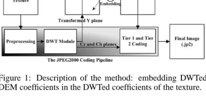
In order to embed the altitude information in the texture map, we propose to follow the protocol illustrated in Figure 1. From a N2 pixel texture image and the corresponding map of m2altitudes, we deduce the embedding factor E = m2/N2
coefficients per pixel. The image of texture will, therefore, have to be divided into square blocks of size equal to d1/Ee pixels and every such block would hide one altitude coeffi-cient. The wavelet transformed Y component of the texture image is extracted from the JPEG2000 pipeline of the open-jpeg encoder in the first place. A discrete wavelet transfor-mation (DWT) is then separately applied to the correspond-ing altitude map. The type of transformation employed in both cases is reversible Daubechies(5/3) with the same level of wavelet decomposition.
Figure 1: Description of the method: embedding DWTed DEM coefficients in the DWTed coefficients of the texture.
To ensure a spatial coherence between the altitudes and the texture, the luminance plane Y in the wavelet domain, at a particular resolution level L, is virtually divided into square blocks of d1/Ee coefficients for data embedding. In each block we embed one information of altitude at the same level L of decomposition. We thus achieve a synchroniza-tion in the embedding as far as the incremental levels of the wavelets are concerned, i.e. low resolution coefficients of the altitude map are embedded in the low resolution sub-bands of texture whereas high resolution coefficients of the altitude map are embedded in the high resolution sub-bands. In this way the transmission of the part concerned with the low res-olution of the texture map enables us to directly access the corresponding low resolution part of the altitude map. The data embedding is carried out by modifying the least signifi-cant bits of a certain number of coefficients of the luminance plane of the texture. These coefficients are chosen by using a pseudo random number generator (PRNG) with a key, K, as a seed. The resultant carrier image, i.e. altered Y plane of the texture in the wavelet domain, is then re-inserted into the JPEG2000 pipeline at the same point from where extracted. The final encoded image (.jp2) thus carries the DEM co-efficients hidden in some DWT coco-efficients. When such a
code is sent across any communication channel, the resolu-tion scalability of wavelets and the synchronized character of our method enable a 3D visualization even with fewer than original resolution layers as a result of partial or delayed data transfer. The method is blind and rather than the original tex-ture image, only the (PRNG) key K is needed to recover the hidden DEM coefficients. This method would enable us to effect a visualization from a fraction of data in the form of the lowest subband, of a particular resolution level. It is al-ways possible to stuff 0’s for the higher bands. The idea is to have a 3D visualization utilizing 3L0+ 1 parts out of the initial 3L + 1 parts (L0≤ L), by stuffing the rest of L − L0parts with 0’s.
4. RESULTS
(a)
(b)
(c) Figure 2: Example images; a) altitude, b) Texture, c) A part of texture magnified.
We have applied our method to a 3200 × 3200 pixel
tex-ture image, illustrated in Figure 2.b, with the associated al-titude map of 64 × 64 coefficients, illustrated in Figure 2.a. For the purpose of comparison a 128 × 128 pixel detail of the above mentioned image of texture is presented in Figure 2.c. Each coefficient of the altitude is coded with 2 bytes imply-ing the embeddimply-ing factor of 1 coefficient per 50 × 50 pixels of texture.
(a)
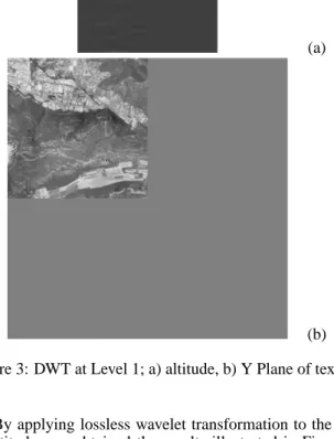
(b) Figure 3: DWT at Level 1; a) altitude, b) Y Plane of texture.
By applying lossless wavelet transformation to the map of altitudes we obtained the results illustrated in Figures 3 for level 1 transformation. The corresponding transformed Y-plane of the texture image is shown in Figure 3.b. For the DWT at level 1, Figure 3.a, the embedding has been done in four parts (LL, LH, HL and HH) whereas for level 3, wavelet decomposition the embedding of data has been re-alized in ten parts. Hence, in general, the data embedding at level L decomposition takes place in 3L + 1 parts. No matter what is the level of decomposition, the difference between the texture image before and after data embedding gave us a mean square error (MSE) of 0.01 corresponding to a PSNR of 68.5 dB since one 16 bit coefficient of the altitude are em-bedded per 50 × 50 block of coefficients of the Y component of texture giving a meager embedding factor of 6.4 × 10⁻³.
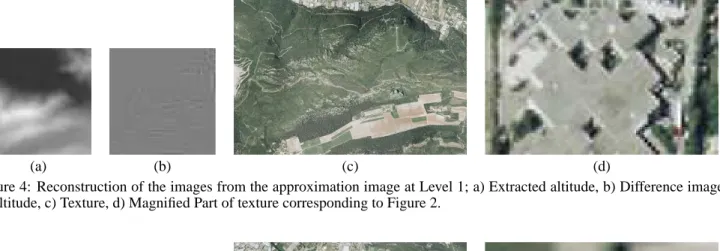
Figure 4.a shows an altitude map reconstructed from the coefficients extracted from a level 1 image of approximation (LL) of the embedded texture image. The reconstruction has been done by stuffing 0’s in place of the three higher bands and applying inverse DWT to the resulting four sub-bands. Thus only 25% of the initial coefficients have been used for reconstruction. The difference of this image with the original altitude resulted in Figure 4.b. When the above pro-cess of reconstruction is applied to the level 1 lowest subband of the embedded texture image Figure 4.c is obtained. For comparison with the original example, the 128 × 128 pixel magnified part is shown in Figure 4.d. The corresponding
(a) (b) (c) (d)
Figure 4: Reconstruction of the images from the approximation image at Level 1; a) Extracted altitude, b) Difference image of altitude, c) Texture, d) Magnified Part of texture corresponding to Figure 2.
(a) (b) (c) (d)
Figure 5: Reconstruction of the images from the approximation image at Level 3; a) Extracted altitude, b) Difference image of altitude, c) Texture, d) Magnified Part of texture corresponding to Figure 2.
(a) (b)
Figure 6: Graphs a) Texture, b) DEM.
images for a level 3 reconstruction, i.e with 1.56% of the ini-tial coefficients, are illustrated in Figure 5. For the subjective analysis of quality, one can visually compare the parts d of Figures 2, 4 and 5, respectively; there is surely degradation in the visual quality but it is far more less than reduction in
the quantity of data.
Objectivity demands a quantitative comparison which we have done in terms of the images of difference by observing the measures, like MSE or PSNR, as a function of compres-sion rate. To elaborate further, MSE has been plotted as a
(a) (b) (c) (d) (e) Figure 7: 3D visualization with the images of approximation of a) Level 0(all the data), b) Level 1, c) Level 2, d) Level 3, e) Level 4.
function of bit rate for the texture (Figure 6.a.) and as a func-tion of bits per coefficient for DEM (Figure 6.b). In the latter case we have plotted MSE against bits per coefficient due to the fact that rather than the whole JPEG2000 encoding only DWT has been applied to the DEM coefficients. The effectiveness of our method is revealed by the fact that even for a compression rate as low as 0.26 bpp (corresponds to level 3 approximation image of texture) one observes a MSE of 184.56 corresponding to a MSE for DEM that has a square root of 22.02 m during visualization. Given the fact that be-ing computed from a small fraction of initial data, this error is tolerable if the observation is made from a very high alti-tude. As can be seen in Figure 6.a. the MSE decreases as further levels of information are added to the image of ap-proximation, e.g for 1.06 bpp (level 2) the MSE is 107.97 and for 4.14 bpp (level 1) the MSE is 42.01. A similar trend is observed in case of√MSE for the DEM (Figure 6.b).
By mapping the texture onto the corresponding DEM a 3D visualization is effected. One can compare the final re-sult between a visualization with all the data (Figure 7.a) and a visualization with the level 1, 2, 3 and 4 (Figure 7.b–e), corresponding to 25%, 6.25%, 1.56% and 0.39% of the trans-mitted coefficients, respectively.
5. CONCLUSION
The data hiding based synchronization process described in this paper is cost effective in terms of memory and band-widths. The results shown in the case of our example are witness to this fact since even with a tiny fraction of coeffi-cients a comparatively better visualization was effected. The resolution scalability of wavelets enables this visualization to improve incrementally with the reception of higher frequen-cies/subbands. Besides, this property is helpful in real-time environment when quicker transfer of data is required. The integrability of our method with the JPEG2000 encoders, like openjpeg, means that there is no need to develop any addi-tional technology or data format, thus implying portability and conformance.
REFERENCES
[1] I. Daubechies and W. Sweldens. Factoring Wavelet Trans-forms into Lifting Steps. Fourier Anal. Appl., 4(3), 1998. [2] M. P. Gerlek. The “GeoTIFF Box” Specification for JPEG
2000 Metadata - DRAFT version 0.0. LizardTech, Inc. 1008 Western Ave Suite 200 Seattle, WA 98104 USA, April 2004. [3] ISO/IEC. ISO/IEC 15444-1: Information technology,
JPEG2000 image coding system, Part 1: Core coding system. 2000.
[4] X. Kong, Y. Liu, H. Liu, and D. Yang. Object Watermarks for Digital Images and Video. Image and Vision Computing, 22:583–595, 2004.
[5] D. Kundur. Improved Digital Watermarking Through Diver-sity and Attack Characterization. In Proc. ACM Workshop on Multimedia Security’99, Orlando, FL, USA, pages 53–58, Oct 1999.
[6] D. Kundur and D. Hatzinakos. A Robust Digital Image Wa-termarking Scheme Using the Wavelet-Based Fusion. In Proc. IEEE Int. Conf. on Image Processing, Santa Barbara, Califor-nia, October 1997.
[7] D. Kundur and D. Hatzinakos. Digital Watermarking Us-ing Multiresolution Wavelet Decomposition. In International Conference on Acoustic, Speech and Signal Processing (IEEE ICASP 98), volume 5, pages 2969–2972, Seattle, Washington, U.S.A., May 1998.
[8] R. Lake, D. Burggraf, M. Kyle, and S. Forde. GML in JPEG 2000 for Geographic Imagery (GMLJP2) Implementa-tion SpecificaImplementa-tion. Number OGC 05-047r2. Open Geospatial Consortium (OGC), 2005.
[9] J.-L. Liu, D.-C. Lou, M.-C. Chang, and H.-K. Tso. A Robust Watermarking Scheme Using Self-Reference Image. Com-puter Standards & Interfaces, 28:356–367, 2006.
[10] S. Mallat. A Wavelet Tour of Signal Processing. Academic Press, 1998.
[11] P. Meerwald. Quantization watermarking in the JPEG2000 coding pipeline. In Communications and Multimedia Security Issues of The New Century, IFIP TC6/TC11 Fifth Joint Work-ing Conference on Communications and Multimedia Security, CMS ’01, pages 69–79, Darmstadt, Germany, May 2001. Klu-ver Academic Publishing.
[12] P. Meerwald and A. Uhl. A Survey of Wavelet-domain Wa-termarking Algorithms. In Proc. of SPIE, Electronic Imaging, Security and Watermarking of Multimedia Contents III, vol-ume 4314, San Jose, CA, USA, January 2001. SPIE, IS&T. [13] A. Piva, F. Bartolini, and R. Caldelli. Self Recovery
Authenti-cation of Images in The DWT Domain. Int. J. Image Graphics, 5(1):149–166, 2005.
[14] P.-C. Su, H.-J. Wang, and C.-C. J. Kuo. An Integrated Ap-proach to Image Watermarking and JPEG-2000 Compression. Journal of VLSI Signal Processing Systems, Special issue on multimedia signal processing, 27(1-2):35–53, June 1997. [15] H.-J. Wang and C.-C.J. Kuo. An Integrated Approach to
Em-bedded Image Coding and Watermarking. In IEEE ICASSP, Seattle, WA, USA, 1998.
[16] X.-G. Xia, C.-G. Boncelet, and G.R. Arce. A multiresolution Watermark for Digital Images. In Proc. IEEE Int. Conf. on Image Processing, 1997.