Publisher’s version / Version de l'éditeur:
Highway Research Record, 463, pp. 18-27, 1973
READ THESE TERMS AND CONDITIONS CAREFULLY BEFORE USING THIS WEBSITE.
https://nrc-publications.canada.ca/eng/copyright
Vous avez des questions? Nous pouvons vous aider. Pour communiquer directement avec un auteur, consultez la
première page de la revue dans laquelle son article a été publié afin de trouver ses coordonnées. Si vous n’arrivez pas à les repérer, communiquez avec nous à [email protected].
Questions? Contact the NRC Publications Archive team at
[email protected]. If you wish to email the authors directly, please see the first page of the publication for their contact information.
NRC Publications Archive
Archives des publications du CNRC
This publication could be one of several versions: author’s original, accepted manuscript or the publisher’s version. / La version de cette publication peut être l’une des suivantes : la version prépublication de l’auteur, la version acceptée du manuscrit ou la version de l’éditeur.
Access and use of this website and the material on it are subject to the Terms and Conditions set forth at
Landslides in sensitive marine clay in Eastern Canada
Eden, W. J.; Mitchell, R. J.
https://publications-cnrc.canada.ca/fra/droits
L’accès à ce site Web et l’utilisation de son contenu sont assujettis aux conditions présentées dans le site LISEZ CES CONDITIONS ATTENTIVEMENT AVANT D’UTILISER CE SITE WEB.
NRC Publications Record / Notice d'Archives des publications de CNRC:
https://nrc-publications.canada.ca/eng/view/object/?id=543b6e74-e736-4ec1-a379-df8fa26914fb https://publications-cnrc.canada.ca/fra/voir/objet/?id=543b6e74-e736-4ec1-a379-df8fa26914fb
Ser
TH1
N211-2
no.
603
c . 2BLDG
&\A
2-I
'd
-LED
NATIONAL RESEARCH COUNCIL OF CANADA .-
CONSEIL NATIONAL DE RECHERCHES DU CANADA
Landslides in Sensitive Marine Clay in Eastern Canada
by
W. J. Eden and R. J. Mitchell
Reprinted from
Highway Research Record No. 463 1973, p. 18-27
Research Paper No. 603
_
_-.
----
of thed,x-b, I - s- 7:: Division of Building Research
_
_,---__---.,--.-.)
c- .
-
LES EBOULEMENTS DANS LJARGILE MARINE SENSIBLE DE LqEST DU CANADA
SOMMAIRE
L e s a u t e u r s p a s s e n t en r e v u e l e s a s p e c t s rhgionaux du probl'eme d e s
hboulements d a n s l e s b a s s e s - t e r r e s du fleuve Saint - L a u r e n t . L e s hboulements d a n s l a rhgion drOttawa sont Ctudihs plus en d h t a i l . On p r o p o s e une mhthode d k n a l y s e d e s pentes qui c o n s i d g r e en p a r t i c u l i e r l e s couches s u p e r f i c i e l l e s d e l'argile exposhes aux a g e n t s a t m o s p h h r i q u e s . On consid'ere Cgalement
Landslides in Sensitive Marine Clay in Eastern Canada
by
LANDSLIDES IN SENSITIVE MARINE CLAY
IN EASTERN CANADA
W. J. Eden, National Research Council of Canada, Ottawa; and R. J . Mitchell, Queen's University, Kingston, Ontario
A brief review of the regional a s p e c t s of the landslide problem in t h e St. Lawrence River lowlands is presented. More detailed studies of landslides in t h e a r e a around Ottawa a r e s t r e s s e d . A method of analysis f o r slopes
is suggested in which p a r t i c u l a r attention is given t o t h e weathered surface l a y e r s of the clay. Some of the conditions leading to l a r g e r e t r o g r e s s i v e landslides a r e considered.
.THE ST. LAWRENCE RIVER lowlands have extensive deposits of sensitive postglacial m a r i n e clay prone t o landslide activity. In t h i s r e s p e c t many s i m i l a r i t i e s exist be- tween the situation in e a s t e r n Canada and that in Norway and Sweden. Certain a r e a s have a history of very l a r g e landslides of t h e earthflow type; the most noteworthy recent landslide, which o c c u r r e d a t Saint J e a n Vianney in May 1971, resulted in t h e l o s s of 31 l i v e s and involved s e v e r a l million cubic y a r d s of clay (30). In such a r e a s t h e location of transportation routes r e q u i r e s m o r e than t h e n o r m a l ~ e o t e c h n i c a l study. F o r ex- ample, eight bridge s i t e s w e r e investigated f o r a c r o s s i n g of t h e South Nation River in e a s t e r n Ontario; s e v e r a l of t h e s e s i t e s w e r e rejected because of t h e dangers presented by a possible earthflow. In May 1971 a l a r g e earthflow occurred c l o s e t o one of the rejected s i t e s (9).
During t h e past 20 y e a r s a number of investigators have conducted detailed geotech- nical studies in a r e a s of intense landslide activity. T h e s e studies indicate that regional differences exist in t h e c h a r a c t e r i s t i c s of t h e deposits and in t h e type of landslide ac- tivity. T h i s paper reviews c e r t a i n regional a s p e c t s of t h e problem but concentrates on t h e analysis of t h e landslide phenomenon in t h e Ottawa a r e a . Two examples of earth- flows and s e v e r a l s m a l l e r landslides will be used to demonstrate t h e behavior of the Ottawa a r e a Champlain Sea clays in landslides.
REGIONAL FEATURES
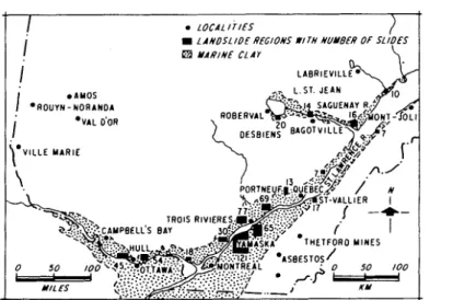
An appreciation of the geological history of t h e sensitive m a r i n e c l a y s of t h e Champ- lain S e a may be gained f r o m various p a p e r s (10, 11, 12, 16). Chagnon (4) p r e p a r e d an inventory of documented landslides in t h e p r o ~ n c ~ o f ~ u ? % e c ; L a ~ o c h e i i e , Chagnon, and Lefebvre (21) extended Chagnon's work by using photogrammetric studies and dis- cussed t h e landslide problems in Quebec. The m a j o r a r e a s of intensive landslide ac- tivity a r e shown in F i g u r e 1. If known landslides in t h e Champlain Sea clay a r e a s of e a s t e r n Ontario w e r e added to Chagnon's inventory, t h e number of past o c c u r r e n c e s would exceed 700. Published information on 50 l a r g e flowslides indicates a total l o s s c l o s e t o 100 l i v e s and approaching 10,000 a c r e s of uplands.
Although all of t h e s e landslides o c c u r r e d in clay deposits of t h e Champlain Sea, im- portant regional differences exist i n t h e physical p r o p e r t i e s of t h e clays. F o r example, t h e consolidation of t h e clay v a r i e s f r o m normally consolidated to an overconsolidation of 10 tons/ft2 (9.76 kg/cm2). Plasticity v a r i e s f r o m v e r y weakly plastic t o plasticity indexes of 40. T h e one common p r o p e r t y is high sensitivity o r l o s s of strength upon disturbance.
Although no generalization is justified without complete knowledge of t h e geology of
valley appear to be either heavily overconsolidated o r very strongly cemented o r both. The mechanical behavior of such clays is described in some detail by Loiselle, Mas- siera, and Sainani (23) and Townsend, Sangrey, and Walker (31). The landslide on the
Toulnustouc River
m
and the Saint Jean Vianney landslide(q
-
occurred in these rela-tively stiff sensitiv&clays.
In the central St. Lawrence lowland, theclays tend to be softer and only lightly over-
consolidated (11). This a r e a has many extensive clay plains of low relief and rather poor drainagexonditions. Some stream courses, such a s the Maskinonge, show s c a r s
of many landslides, frequently side by side (Fig. 2). Karrow (17) describes the land-
slide problem on two topographic map sheets from the area, a n d L a Rochelle and his coworkers (21) illustrate the situation along the Yamaska River. Other landslides that
have been documented from the region occurred at St. Thuribe (28) and at Nicolet (2,
-
-
13).
-
, -The Ottawa River valley, because of its higher elevation, may in general tend to have
better drainage conditions than the a r e a east of Montreal. Many clay slopes in the Ottawa a r e a have developed a weathered crust of clay that i s considerably stronger than the underlying clay. The crust may extend to depths of 10 to 20 ft, and a part of the initial slip develops in this weathered material. The Ottawa a r e a clays also have
a postglacial history of erosion and redeposition due to influx of fresh water from the
Great Lakes through the Ottawa River at one stage (10). Redeposited clays overlie the
marine clays to significant depths, and most of the 1Gdsliding is thought to develop in
the redeposited materials. Sangrey and Paul (29) discuss this situation a s it pertains
-
to the Green Creek valley east of Ottawa.
Although some of the marine clays in the Ottawa a r e a exhibit a brittle type of be- havior (5), the redeposited clays and the clays in the weathered crust show a dilatant frictionzl type of shear behavior under low normal s t r e s s levels, such a s prevail in the initial stages of a landslide. This type of shear mechanism has been demonstrated by J a r r e t t (15) and Ladanyi and Archambault (19) a s well a s by the present authors (7).
The shearmechanism is considered to arisFbecause of inherent defects o r planes of
weakness in the clay and results in a curved failure envelope. In many cases the land-
slide activity is confined to one o r two slips (Fig. 3). The debris from such slides has a granular-like appearance and is composed mainly of fissured clay. Occasionally large-scale retrogressive failures follow the initial slip, with the softer, more sensitive, underlying clay becoming involved, and large earthflows develop such as the South Nation River landslide (Fig. 4). In such cases much of the debris becomes completely remolded with only the dry surface layers remaining intact a s blocks in a mass of semifluid material.
LANDSLIDE ANALYSES Initial Sliding
For the curved failure envelope generally found to be applicable to initial slope fail- ure in the Ottawa valley the empirical strength parameters c ' and 4' a r e variables that depend on the effective normal s t r e s s . c ' and 4' a r e apparent strength parameters de- termined in drained triaxial strength t e s t s in the appropriate range of normal stresses. These apparent properties reflect the dilatant tendencies of the material, such a s de-
scribed by Ladanyi and Archarnbault (19). Although it is possible to develop analytical
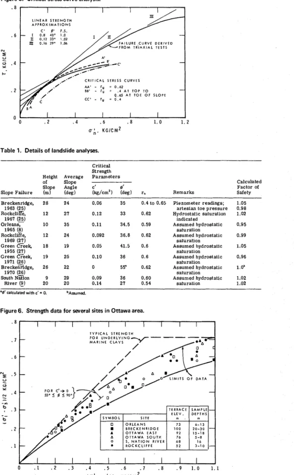
procedures for variable strength p a r a z e t e r s , the critical s t r e s s curve method o r a linear approximation of the curved failure envelope over the appropriate s t r e s s range is an acceptable alternative in computing factors of safety.
The critical s t r e s s curve method can be facilitated by the use of computers; a direct solution to Bishop's equation will yield the value of c ' that gives a factor of safety of unity for a g i v e n ' and given slope conditions. Various combinations of c ' and 4' giving a factor of safety of unity for the critical circle will define a critical s t r e s s point in
(7, 0,') space. The critical s t r e s s curve joins critical s t r e s s points calculated for cir-
cles found to be critical f o r the range of 4' values applicable to the curved strength en- velope. This subroutine has been programmed by Arseneault (I), and the program was
l a t e r modified to incorporate
a
variable r, parameter ('7), wherer, is
the pore pressureFigure 1. Marine clay and landslide distribution in Quebec (21).
Figure 2. Landslide scars along Maskinonge River Figure 3. Landslide on Green Creek, 1971. (RCAF photograph).
Typical r e s u l t s f r o m a c r i t i c a l s t r e s s c u r v e analysis a r e shown in Figure 5. Limit- ing equilibrium is predicted when the slope conditions a r e such that the critical s t r e s s curve becomes tangent to o r coincident with the failure envelope. The l a t t e r condition, indicating that a number of s l i p c i r c l e s reach c r i t i c a l equilibrium at the s a m e time, is often found t o be the c a s e when r e t r o g r e s s i v e f a i l u r e s have followed initial sliding. The minimum factor of safety can be obtained as t h e minimum ratio T/?, where T is t h e
s h e a r strength at a given value of a,' and 5 is the average s h e a r strength required f o r stability and is obtained f r o m t h e c r i t i c a l s t r e s s c u r v e at that value of a,,'. If it is shown that f a c t o r s of safety can be predicted t o g r e a t e r accuracy than obtained by t h i s graph-
ical method, t h e s e f a c t o r s can be calculated for t h e c r i t i c a l c i r c l e s by means of an iterative subroutine. The graphical method facilitates direct comparison of stability of slopes with.variable r, factors and variable strength parameters.
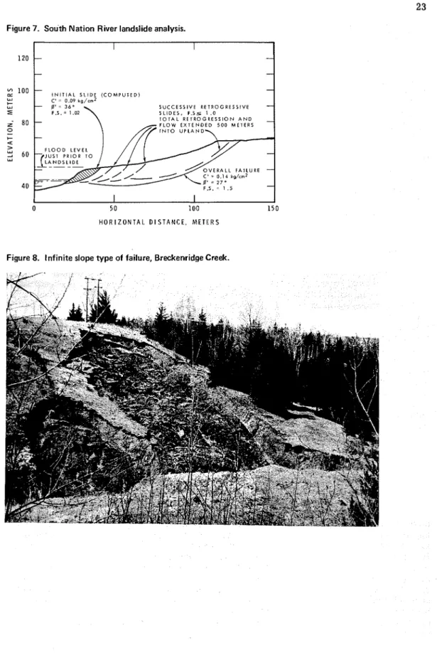
A number of documented slope f a i l u r e s in the Ottawa a r e a have been analyzed by using t h i s method; relevant data a r e given in Table 1. A calculated factor of safety close t o unity w a s found t o correspond, in most c a s e s , to hydrostatic saturation of the slope. Tension c r a c k s have been noted p r i o r t o failure (26), and hydrostatic saturation may be due t o s u r f a c e water infiltration into t h e s e openin=. Eden (6) d e s c r i b e s a c a s e where surface w a t e r w a s observed entering the soil via tension c r a c k s a few hours p r i o r to failure of the slope.
T h e l a r g e variations in t h e values of c ' and 0' used in the analyses given in Table 1 result f r o m the variations in average depth of failures, hence the point of tangency of the c r i t i c a l s t r e s s curve and t h e curved failure envelope. Actual variations in soil strength f r o m various s i t e s in t h e Ottawa valley region a r e shown in Figure 6. T h e data in Figure 6 include a variety of sample s i z e s , sample orientations, and type of s a m p l e s (block and tube samples); little, if any, reduction in shearing r e s i s t a n c e a f t e r failure o c c u r s in t h i s s t r e s s range (25). T h e r e a r e a few outcroppings of t h e intact marine clay in t h e Ottawa valley ( l o g ) , and t h e s e c l a y s yield
-
-
a peak strength envelope, represented by t h e dashed line i n Figure 6, with considerable l o s s in shearing r e s i s - tance after peak strength. A 30 percent variation in strength of s a m p l e s obtained f r o m different s i t e s is shown in Figure 6. Detailed strength testing is necessary at any given s i t e if usually accepted f a c t o r s of safety (1.2 to 1.5) f o r long-term slope stability a r e t o be used. T h e s e data also indicate that d' r 55 deg f o r c ' = 0, where @'is t h e apparent angle of obliquity.T h e depth of initial failure in most of t h e c a s e s documented is considered t o extend below the depth of active weathering. F o r a curved failure criterion, the depth and location of the c r i t i c a l c i r c l e depend mainly on the slope geometry and any a d v e r s e groundwater conditions. T h r e e examples will s e r v e to indicate t h i s dependence.
Breckenridge Landslide, 1963-A c r i t i c a l c i r c l e encompassing t h e e n t i r e slope at Breckenridge and giving a factor of safety of about 1.05 is predicted on the computer by using the average measured groundwater conditions (r, = 0.4). When the variation in groundwater p r e s s u r e w a s considered and by using the variable r, program, a cal- culated factor of safety of 0.98 was obtained and the c r i t i c a l c i r c l e w a s predicted t o e m e r g e about midway up the slope (7). The position of t h i s predicted c i r c l e s a t i s f i e s the kinematic r e s t r i c t i o n s s u g g e s t e a b y Kenney and Ali (18). T h i s example shows that the location of the c r i t i c a l c i r c l e is dependent on variations in r,, a factor of importance in considering stabilization methods and the possibility of retrogression.
South Nation River Landslide, 1971-Almost
%
mile of initial failure a t t h i s s i t e oc- c u r r e d in slopes with profiles a s shown in Figure 7. An analysis of t h e overall slope yields a factor of safety of about 1.5. It is known, however, that the failure occurred under drawdown conditions (9). When a toe failure was considered (using r, = y,/y,,,,t o approximate rapid drawdown), a factor of safety of 1.02 was obtained. Table 1 shows that an identical factor of safety w a s obtained for a uniform 20-deg slope that failed n e a r the southwesterly l i m i t s of t h i s landslide. T h e strength p a r a m e t e r s applicable t o t h e s e two f a i l u r e s in exactly the s a m e m a t e r i a l a r e different because of the different depths of m a t e r i a l involved in the initial slide. T h i s example shows t h e importance of allowing sufficient latitude i n t h e s e a r c h a r e a and considering t h e experimental v a r i a - tions of c ' and 0' when slopes with variable two-dimensional geometry a r e analyzed. T h e relevant c r i t i c a l c i r c l e s a r e shown in Figure 7.
Figure 5. Critical stress curve analysis.
Table 1. Details of landslide analyses.
Critical Strength Height Average P a r a m e t e r s
of Slope
Slope Angle c' 0'
Slope Failure (m) (deg) (kg/cm2) (deg) r. Remarks
Calculated Factor of Safety Breckenridge, 28 24 0.06 35 0.4 to 0.65 Piezometer readings; 1.05
1963 (25) artesian toe p r e s s u r e 0.98
RockcliZfe, 12 27 0.12 33 0.62 Hvdrostatic saturation 1.02
1967 (25) indicated
O r l e a n s i 10 35 0.11 34.5 0.59 Assumed hydrostatic 0.95
1965 (8) saturation
~ o c k c l i E e , 12 24 0.092 36.8 0.62 Assumed hvdrostatic 0.99
1969 ( ~ j saturation
Green Creek, 1 8 19 0.05 41.5 0.6 Assumed hydrostatic 1.05
1955 (27) saturation
Green CTeek, 19 25 0.10 36 0.6 Assumed hydrostatic 0.96
1971 (26) saturation
Breckenridge, 26 22 0 55' 0.62 Assumed hydrostatic 1.0'
1970 (26) saturation
South Nzion 9 29 0.09 36 0.60 Assumed hydrostatic 1.02
River (9) 20 20 0.14 27 0.54 saturation 1.02
'0' calculated with c' = 0. 'Amrned.
Figure 7. South Nation River landslide analysis.
1
I I1
0 50 100 150
H O R I Z O N T A L D I S T A N C E . M E T E R S
Breckenridge Landslide, 1970-If the curved failure envelope in Figure 6 is presumed to pass through the origin of coordinates, the critical c i r c l e may be surficial; surficial sloughing is noted in actively eroding slopes with little vegetative cover, but several documented initial failures approximate reasonably well to circular a r c sliding (8, 27). - - The end condition at the toe, stiffer weathered c r u s t a l material, and reinforcing root s t r u c t u r e s a r e factors that make surficial infinite slope failure l e s s critical. Where sufficient removal of toe support occurs because of natural erosion o r construction ac- tivities, infinite slope sliding may occur; an example of this type of sliding on the Breckenridge Creek i s reported by Mitchell and Eden (26) and is shown in Figure 8. By using the equation for infinite slope sliding (2) withy" = y,/y and
fl
= 22 deg (condi-I
tions applicable to this failure), a value of 0' = 55/2 deg is obtained at critical equilib- rium (factor of safety = unity). Analyzed by using the values of c ' and 0' applicable to the 1963 Breckenridge landslide, a factor of safety in excess of unity would be obtained f o r the critical circle.
The 10 analyses of slope failures given in Table 1 w e r e c a r r i e d out using strength data from laboratory t e s t s . Calculated factors of safety a r e 110.05. These data sug- gest that the long-term factor of safety of a slope in the Ottawa a r e a can be calculated with some confidence by using the approach outlined above.
Retrogressive Sliding
Early Canadian geological literature contains many classic descriptions of large landslides in the Champlain Sea clays. Very little information about soils is contained in these reports and the geotechnical r e s e a r c h effort h a s been concerned mainly with mapping a r e a s of known slide activity (14, - - 21). Meyerhof (24),
-
however, presents and compares some soils data f r o m various large landslides. The occurrence of two very l a r g e landslides in the spring of 1971-the Saint J e a n Vianney slide (30) and the South Nation River slide (9)-provided opportunities f o r the s o i l s conditionFat the s i t e s of these landslides to Fe investigated. Because these investigations a r e still in progress, the discussion herein will be restricted to a description of retrogressive mechanisms.Eden and Mitchell (7) showed that computed factors of safety for circular a r c retro- gression following inityal slope failure a r e significantly l e s s than unity in c a s e s where field observations indicated that retrogressive sliding did occur. Stability analysis based on drained test data cannot, however, be extended t o multiple retrogressions; after several retrogressive slides have developed, further retrogression must be treated as a "short-term" undrained stability problem. Elements of soil a r e sheared undrained from the in situ K, condition, and the peak shearing resistance is represented, f o r Champlain Sea clays, by a cementation strength (5, 3 1). Because the cementation - - strength is in excess of the frictional strength commensurate with the in s i t ~ voids ratio, a reduction in shearing resistance in undrained t e s t s i s observed after the peak strength. Such strain-softening characteristics should be considered if accurate factors of safety a r e to be calculated for undrained slope failures. A method f o r developing local residual factors to be applied in the standard upper bound solution to short-term slope stability in Champlain Sea clay has been presented by Lawrence (22).
Field evidence indicates that spoil from l a r g e retrogressive 1andslidTs i s largely remolded and exhibits viscous o r plastic flow. These landslides a r e generally associ- ated with soft underlying materials o r with interbedded s i l t s and fine sands. It would appear that the failure mechanism involves extrusion and/or liquefaction. Extrusion may occur where the material i s cohesive (largely clay minerals), whereas liquefaction
is a possible mechanism when loose s i l t s and sands a r e interbedded with the clays. An elastic, perfectly plastic, finite-element s t r e s s analysis f o r slopes in Champlain Sea clay (22) indicates that a confined plastic zone (yielded zone) would form near the base of a s E p e and would extend to a f r e e boundary n e a r the toe (such that extrusion would occur) when t h e factor of safety, based on upper bound analyses, approached unity. Strain softening would lead t o g r e a t e r yielding and e a r l i e r extrusion. Landslides that continue t o r e t r o g r e s s in an undrained manner by either extrusion o r liquefaction a r e termed "flowslides."
It is believed that all landslides in the Ottawa a r e a were initiated by a single rota- tional slide'. In many cases several retrogressive s l i c e s failed, but the slope height was insufficient t o cause undrained failure and the retrogression was terminated. In a few c a s e s the retrogression developed into a flowslide.
At least one case record indicates that l a r g e landslides may develop by mechanisms other than flowsliding. A landslide on the Toulnustouc River, Quebec, involving about 5 million cubic yards of Champlain Sea deposits, i s considered to have developed a s a progressive, infinite slope type of slide (5). The deposits at the site of the slide a r e interbedded overconsolidated s i l t s and clzy s i l t s that dip at a maximum angle of 10 deg toward the Toulnustouc River. The failure plane is considered to have followed the bedding planes. This case record indicates that progressive failure at o r near residual strength may develop under the appropriate geological conditions. As already men- tioned, the Ottawa a r e a Champlain Sea deposits a r e normally lightly overconsolidated and the mechanism of progressive sliding i s not considered relevant.
DESIGN AND CONTROL CONSIDERATIONS
High groundwater p r e s s u r e s and active toe erosion appear to be the major natural factors that cause a slope to become unstable. Ideally, pore water p r e s s u r e measure- ments should be taken when the stability of a slope is evaluated; such measurements a r e considered essential if there i s any indication of artesian conditions. Mitchell and Eden (26) measured deep-seated creep movements in slopes where the calculated factor of s a f e 3 was l e s s than 1.25. The possibility of creep movements opening up tension cracks and permitting the direct entry of surface water to critical zones, thus promoting failure, must be considered. If the calculated factor of safety of a slope, where r, i s everywhere l e s s than y,/y, is l e s s than about 1.5, it is recommended that the long-term factor of safety of that slope be evaluated by using r,, = y,/y (full hydrostatic saturation). If tension cracks a r e noted in a slope it would be advisable to cover o r s e a l them with relatively impervious materials until permanent stabilization methods can be adopted. The w r i t e r s know of several slopes in the Ottawa a r e a where tension cracks were visible
1 o r 2 years p r i o r to slope failure. Testing of soils in the low s t r e s s range (under low confining p r e s s u r e s ) and considering the variance of c ' and 9' with confining p r e s s u r e a t failure a r e necessary if the minimum factor of safety for a given slope i s to be ob- tained from an analysis.
A large measured frictional component of strength and the general high groundwater conditions in natural slopes suggest that toe drains may be useful in ensuring the sta- bility of slopes. A small slope failure occurred just east of Ottawa in May 1972, but similar adjacent slopes with toe drains remained stable. The toe drains had been in- stalled in connection with a development close to the slope terrace. No other field ex- perience with this type of drain in the Ottawa a r e a i s known t o the writers.
Possible future erosion of the toe must be considered when the long-term stability of r i v e r banks is evaluated. A section of the south bank of the Ottawa River is cur- rently being stabilized against ice and water erosion with rock from excavations in downtown Ottawa. Cooperative endeavors such a s this would appear to provide an eco- nomical answer to eventual stabilization of natural slopes on well-developed r i v e r banks. In actively eroding r i v e r systems, where erosion will inevitably initiate sliding, mea- s u r e s of controlling o r preventing retrogression and/or flowsliding may be possible. Landslide warning systems perhaps s i m i l a r t o systems used in the mining industry to warn against rock bursts should be developed in hopes of preventing loss of life due t o flowsliding.
CONCLUSIONS
In this paper, the authors have attempted t o describe some of the facets of the land- slide problem in the marine clay deposits of eastern Canada. The importance of local geological conditions has been indicated by reference to several landslides studied in the Ottawa area. The type and extent of the landslide a r e determined by the prevailing local geology. From a study of a number of landslides, an analytical and testing pro- cedure has been found that has been reasonably successful in i t s application to stability
problems. Although t h e detailed sampling and testing required in t h e application of t h e s e procedures may not be applicable t o all routine slope stability investigations, an understanding of the concepts of a highly frictional behavior and dilatancy a t low s t r e s s l e v e l s and a curved f a i l u r e envelope may a s s i s t in a s s e s s i n g remedial m e a s u r e s such
as slope flattening, t o e b e r m s , o r drainage provisions. In studies of c r i t i c a l slopes, detailed testing and analysis should b e justified s o that a b e t t e r c o r r e l a t i o n can be con- ducted against t h e existing background of information.
When detailed investigations indicate that a f a i l u r e may occur, t h e consequences of subsequent r e t r o g r e s s i o n and a possible flowslide must b e considered. Until t h e mech- a n i s m s and conditions leading t o r e t r o g r e s s i o n a r e b e t t e r understood, t h e mapping of a r e a s of past r e t r o g r e s s i v e landslide activity a p p e a r s t o be t h e best approach f o r plan- ning purposes.
In s u m m a r y t h i s p a p e r h a s attempted t o d e m o n s t r a t e that
1. Local geological conditions a r e important t o t h e type and extent of landslide ac- tivity;
2. T h e initial p h a s e s of a landslide frequently take place i n f i s s u r e d clay, which behaves in a distinct manner;
3. No single s h e a r f a i l u r e c r i t e r i o n is valid because f a i l u r e may develop simulta- neously on a number of planes; and
4. T h e possibility of r e t r o g r e s s i v e landslides and l a r g e e a r t M o w s must be con- sidered.
ACKNOWLEDGMENTS
T h e i n t e r e s t and contributions of o t h e r r e s e a r c h e r s and practicing geotechnical con- sultants in t h e Ottawa a r e a a r e gratefully acknowledged. T h i s paper is a joint contri- bution of t h e Department of Civil Engineering, Queen's University, Kingston, and t h e Division of Building Research, National R e s e a r c h Council of Canada.
REFERENCES
1. Arseneault, J. G. A P r o g r a m f o r Solving Slope Stability P r o b l e m s . National Re- s e a r c h Council of Canada, Div. of Building Research, Comp. P r o g . 27, Ottawa, 1967. 2. Beland, J. Nicolet Landslide, November 1955. P r o c . Geological Association of
Canada, Vol. 8, Pt. 1, 1956, pp. 143- 156.
3. Bishop, A. W., and Morgenstern, N. R. Stability Coefficients f o r E a r t h Slopes. Geotechnique, Vol. 10, No. 4, 1960, pp. 129-150.
4. Chagnon, J-Y. L e s Coulees d'Argile dans la Province de Quebec. Naturaliste Can., Vol. 95, 1968, pp. 1327- 1343.
5. Conlon, R. J. Landslide on t h e Toulnustouc River, Quebec. Canadian Geotechnical Jour., Vol. 5, No. 1, 1966, pp. 28-45.
6. Eden, W. J. Some Observations a t L e Coteau Landslide, Gatineau, Quebec. Canadian Geotechnical Jour., Vol. 9, No. 4, 1972, pp. 508-514.
7. Eden, W. J., and Mitchell, R. J. T h e Mechanics of Landslides in Leda Clay. Canadian Geotechnical Jour., Vol. 7, No. 3, 1970, pp. 285-296.
8. Eden, W. J., and J a r r e t t , P. J. Landslide at Orleans, Ontario. National Research Council of Canada, Div. of Building Research, Tech. P a p e r 321, Ottawa, 1971. 9. Eden, W. J., Fletcher, E. B., and Mitchell, R. J. T h e South Nation River Landslide,
16 May 1971. Canadian Geotechnical Jour., Vol. 8, No. 3, 1971, pp. 446-451. 10. Gadd, N. R. Surficial Geology of Ottawa Map Area, Ontario and Quebec. Geological
Survey of Canada, P a p e r 62- 16, 1962.
11. Gadd, N. R. Pleistocene Geology of Central St. Lawrence Lowland. Geological Survey of Canada, Memo. 359, 1971.
12. Gadd, N. R., Lasalle, P., Dionne, J. C., Shilts, W. W., and McDonald, B. C. Qua- t e r n a r y Geology and Geomorphology, Southern Quebec. 24th Internat. Geological Congress, Montreal, Guidebook, Field Excursion A-44 C-44, 1972.
13. Hurtubise, J. E., and Rochette, P . A. T h e Nicolet Slide. Committee on Soil and Snow Mechanics, National R e s e a r c h Council of Canada, Ottawa, Tech. Memo. 48, May 1957.
14. Hurtubise, J. E., Gadd, N. R., and Meyerhof, G. G. L e s Eboulements d e T e r r a i n dans 1'Est du Canada. P r o c . 4th Internat. Conf. on Soil Mechanics and Foundations Engineering, Vol. 2, London, 1957, pp. 325-329.
15. J a r r e t t , P . M. The Effects of Soil S t r u c t u r e on t h e Engineering Behavior of a Sen- sitive Clay. Q u a r t e r l y J o u r . Engineering Geology, Vol. 5, 1972, pp. 103-109. 16. Karrow, P. F . The Champlain S e a and I t s Sediments. In Soils in Canada (Legget,
R. F., ed.), Royal Society of Canada, Spec. Publ. 3, U n i c o f Toronto P r e s s , 1961. 17. Karrow, P . F . Earthflows i n the Grondines and T r o i s ~ i v i e r e s Areas, Quebec.
Canadian J o u r . E a r t h Sciences, Vol. 9, No. 5, 1972, pp. 561-573.
18. Kenney, T . C., and Ali, M. Discussion: Stability of Natural Slopes in Sensitive Clay. P r o c . ASCE, J o u r . Soil Mechanics and Foundations Div., Vol. 94, No. SM5, 1968, pp. 1185- 1190.
19. Ladanyi, B., and Archambault, G. Simulation of Shear Behavior of a Jointed Rock Mass. 1 l t h Symposium on Rock Mechanics, Berkeley, Calif
.,
1969.20. L a Rochelle, P. L e s Coul6es d'Argile a u Quebec. ~ ' ~ n g & n i e u r , Vol. 58, No. 280, 1972, pp. 47-53.
2 1. L a Rochelle, P., Chagnon, J-Y., and Lefebvre, G. Regional Geology and Landslides in Marine Clay Deposits of E a s t e r n Canada. Canadian Geotechnical Jour., Vol. 7, No. 2, 1970, pp. 145-156.
22. Lawrence, V. M. Stability of Slopes in Naturally Cemented Soils. PhD thesis, Queen's Univ., Kingston, Ontario, 1971.
23. Loiselle, A., Massiera, M., and Sainani, U. R. A Study of t h e Cementation Bonds of Sensitive Clays of Outardes R i v e r Region. Canadian Geotechnical Jour., Vol. 8, NO. 3, 1971, pp. 479-498.
24. Meyerhof, G. G. T h e Mechanism of Flow Slides in Cohesive Soils. Geotechnique, Vol. 7, NO. 1, 1957, pp. 41-49.
25. Mitchell, R. J. Landslides a t Breckenridge, Pineview Golf Club and Rockcliffe. National R e s e a r c h Council of Canada, Div. of Building Research, Tech. P a p e r 322, Ottawa, 1970.
26. Mitchell, R. J., and Eden, W. J. Measured Movements of Clay Slopes i n t h e Ottawa Area. Can. J o u r . of E a r t h Sciences, Vol. 9, No. 8, 1972, pp. 1001- 1013.
27. Paul, M. J. Landsliding i n Sensitive Clay Soils a t Ottawa. MSc t h e s i s , Queen's University, Kingston, Ontario, 1970.
28. Peck, R. B., Ireland, H. O., and Fry, T . S. Studies of Soil C h a r a c t e r i s t i c s in Earth- flows of St. Thuribe, Quebec. Dept. of Civil Engineering, Univ. of Illinois, Urbana, Soil Mech. S e r . 1, 1951.
29. Sangrey, D. A., and Paul, M. J. A Regional Study of Landsliding Near Ottawa. Canadian Geotechnical J o u r . , Vol. 8, No. 2, 1971, pp. 315-335.
.
30. Tavenas, F., Chagnon, J-Y., and L a Rochelle, P . Saint Jean-Vianney Landslide: Observations and Eyewitnesses Accounts. Canadian Geotechnical Jour., Vol. 8, NO. 3, 1971, pp. 463-478.31. Townsend, D., Sangrey, D. A., and Walker, L. K. T h e B r i t t l e Behaviour of Natu- r a l l y Cemented Soils. P r o c . 7th Internat. Conf. on Soil Mechanics and Foundations Engineering, Mexico, Vol. 1, 1969, pp. 411-417.