HAL Id: hal-02279803
https://hal.archives-ouvertes.fr/hal-02279803
Submitted on 4 Nov 2020
HAL is a multi-disciplinary open access archive for the deposit and dissemination of sci-entific research documents, whether they are pub-lished or not. The documents may come from teaching and research institutions in France or abroad, or from public or private research centers.
L’archive ouverte pluridisciplinaire HAL, est destinée au dépôt et à la diffusion de documents scientifiques de niveau recherche, publiés ou non, émanant des établissements d’enseignement et de recherche français ou étrangers, des laboratoires publics ou privés.
the Eastern Great Hungarian Plain for the last
20,000 years
Ildikó Vincze, Walter Finsinger, Gusztáv Jakab, Mihály Braun, Katalin
Hubay, Daniel Veres, Tamás Deli, Zoltán Szalai, Zoltan Szabó, Enikö Magyari
To cite this version:
Ildikó Vincze, Walter Finsinger, Gusztáv Jakab, Mihály Braun, Katalin Hubay, et al.. Pa-leoclimate reconstruction and mire development in the Eastern Great Hungarian Plain for the last 20,000 years. Review of Palaeobotany and Palynology, Elsevier, 2019, 271, pp.104112. �10.1016/j.revpalbo.2019.104112�. �hal-02279803�
Paleoclimate reconstruction and mire development in the Eastern Great Hungarian Plain for the last 20,000 years
Ildikó Vincze, Walter Finsinger, Gusztáv Jakab, Mihály Braun, Katalin Hubay, Daniel Veres, Tamás Deli, Zoltán Szalai, Zoltán Szabó, Enikő Magyari
PII: S0034-6667(19)30121-6
DOI: https://doi.org/10.1016/j.revpalbo.2019.104112
Reference: PALBO 104112
To appear in: Review of Palaeobotany and Palynology
Received date: 29 April 2019
Revised date: 28 August 2019
Accepted date: 31 August 2019
Please cite this article as: I. Vincze, W. Finsinger, G. Jakab, et al., Paleoclimate reconstruction and mire development in the Eastern Great Hungarian Plain for the last 20,000 years, Review of Palaeobotany and Palynology(2018), https://doi.org/10.1016/ j.revpalbo.2019.104112
This is a PDF file of an article that has undergone enhancements after acceptance, such as the addition of a cover page and metadata, and formatting for readability, but it is not yet the definitive version of record. This version will undergo additional copyediting, typesetting and review before it is published in its final form, but we are providing this version to give early visibility of the article. Please note that, during the production process, errors may be discovered which could affect the content, and all legal disclaimers that apply to the journal pertain.
Journal Pre-proof
Palaeoclimate reconstruction and mire development in the Eastern Great Hungarian Plain for the last 20,000 years
Ildikó Vincze1,2,3*, Walter Finsinger4, Gusztáv Jakab5,6, Mihály Braun3, Katalin Hubay3, Daniel Veres7, Tamás Deli8, Zoltán Szalai9,10, Zoltán Szabó10, Enikő Magyari1,3,10
1 MTA-MTM-ELTE Research Group for Paleontology, H-1117 Budapest, Pázmány Péter str. 1/C, Hungary 2
Department of Physical and Applied Geology, Eötvös Loránd University, H-1117 Budapest, Pázmány Péter str. 1/C, Hungary
3
Isotope Climatology and Environmental Research Centre (ICER), Institute for Nuclear Research, Hungarian Academy of Sciences, H-4026 Debrecen, Bem square 18/C, Hungary
4
ISE-M, University of Montpellier EPHE, IRD, Montpellier, France
5 Szent István University, Faculty of Economics, Agricultural and Health Studies, H-5540, Szarvas, Szabadság
str. 1-3., Hungary
6
Hungarian Academy of Science – Institute of Archaeology, Research Centre for the Humanities, H-1014 Budapest, Úri str. 49., Hungary
7
Institute of Speleology, Romanian Academy, Clinicilor 5, 400006 Cluj-Napoca, Romania
8
biologist-researcher, H-5500 Gyomaendrőd, Móricz Zs. str. 2., Hungary
9 Hungarian Academy of Science – Research Centre for Astronomy and Earth Sciences, Geographical Institute,
H-1112, Budapest, Budaörsi str. 45., Hungary
10
Department of Environment and Landscape Geography, Eötvös Loránd University, H-1117 Budapest, Pázmány Péter str. 1/C, Hungary
*
Corresponding author: Ildikó Vincze, Eötvös Loránd University Department of Physical and Applied Geology, H-1117 Budapest, Pázmány Péter sétány 1/C, Hungary. Tel.: +36-1-372-2500/ext. 1738.
Journal Pre-proof
Abstract
We present the reconstruction of mire vegetation changes and fire history recorded in a continuous sediment profile that spans the last 20,000 cal yr BP from the Late Pleniglacial to Holocene in North-eastern Hungary. We also aimed to reveal past climate changes by using ecological requirements of specific aquatic plants as summer temperature indicators. Our results suggest the formation of a mesotrophic mire around 20,000 cal yr BP with brown moss, Betula sp. and Selaginella selaginoides cover beside the occurrence of Phragmites australis, Typha latifolia and T. angustifolia suggesting base-rich fen and tundra-like wet-ground habitats on the lakeshore. This community shifted to reed dominated swamp at c. 18,300 cal yr BP with inferred min. July temperatures of 12–15.7°C. Pinus sp., Betula nana, B. pendula/pubescens, Hippuris vulgaris and P. australis dominated until 16,600 cal yr BP pointing to shallow muddy stagnant water and colder climatic conditions than in the preceding interval. The most warmth-demanding species, T. latifolia and T. angustifolia indicated July mean temperatures > 14-15.7°C soon after the LGM. The formation of biogenic carbonate also started at an early stage; major accumulation occurred between 15,200 and 10,000 cal yr BP. In the Early Holocene, environmental indicator species (e.g. Phragmites australis and T. latifolia) pointed to warmer and shallower conditions, while the late Holocene was characterised by strong eutrophication and reed swamp dominance on the lakeshore. Elevated macrocharcoal concentration, wood fragments and remains of Typha species suggested frequent local fires and dry mire surface conditions during the last 1700 years.
Keywords: plant macrofossil, vegetation reconstruction, Late Pleniglacial, Lateglacial, Carpathian
Journal Pre-proof
Introduction
Climate warmed with varying amplitude at different latitudes after the Last Glacial Maximum (LGM: 26,500–19,000 cal yr BP according to Clark et al., 2009), followed by rapid warming at the onset of the Holocene (from ca. 11,700 cal yr BP according to Rasmussen et al., 2014). Proxies reflecting past climate change can be found in lake and mire sediments, and climate reconstructions are often based on biological proxies, such as pollen (e.g. Aarnes et al., 2012; Huntley et al., 1993, Seppä et al., 2004), chironomids (e.g. Heiri et al., 2003; Lotter et al., 1997; Tóth et al., 2012, 2015) and plant macrofossils (e.g. Björkman et al., 2003; Feurdean, 2005; Feurdean et al., 2007b; Feurdean and Bennike, 2004; Jakab et al., 2005; Magyari et al., 1999, 2009, 2012a, 2008). In general, these paleoclimate records reflect the pronounced climatic fluctuation also detected in the Greenland ice-core stable isotope data (Rasmussen et al., 2014) and provide major information about the long-term variability of climate. Relatively few biological proxy records exist for the Late Pleniglacial (LPG: 24,000– 14,600 cal yr BP) across Europe (e.g. Binney et al., 2017; Gobet et al., 2010; Kaltenrieder et al., 2009). Some pollen and plant macrofossil studies are available from North-eastern (Alm and Birks, 1991; Heikkilä et al., 2009; Wohlfarth et al., 2006) and East-Central Europe (Björkman et al., 2003; Feurdean et al., 2007; Jankovska & Pokorný, 2008; Magyari et al., 1999, 2012a, 2014; Pokorný, 2002; Wohlfarth et al., 2001), and they mostly indicate the scattered presence of trees in East-Central and Southern Europe during the LPG (Gałka et al., 2014; Tantau et al., 2006; Tonkov et al., 2011; Tzedakis et al., 2013; Willis et al., 2000a; Willis and van Andel, 2004). In addition, several multiproxy records cover the LPG and Lateglacial in Poland (e.g. Fajer et al., 2012; Gałka & Sznel, 2013; Kołaczek et al., 2015; Milecka et al., 2011), in the Czech Republic (Engel et al., 2010; Rybníček & Rybníčková, 1968; Pokorný, 2002; Pokorný et al., 2010) and in Romania (Björkman et al., 2003; Feurdean
Journal Pre-proof
et al., 2007; Magyari et al., 2009, 2012a, 2014a). There are particularly few sites in Hungary where the LGM and the early period after the Last Glacial Maximum have been studied by Medzihradszky & Bajzáth (1998), Magyari et al. (1999), Jakab et al. (2005) and Rudner & Sümegi (2001).
Pollen-based summer temperature reconstructions are predominantly driven by changes in the major arboreal and non-arboreal pollen taxa (Seppä et al., 2004) and in case of large lakes with large pollen source area they presume that the pollen record reflects the regional vegetation and therefore regional climate change (Seppä et al., 2004; Whitmore et al., 2005). In addition, low taxonomic resolution is a serious limiting factor in case of the pollen based reconstructions, as pollen grains are infrequently identifiable to species level (Ortu et al., 2006; Seppä et al., 2004). This is especially critical in pollen based temperature reconstructions when trees are rare or even absent in the study area (Aarnes et al., 2012). Many early studies recognised that the aquatic plant remains may provide more accurate temporal records of climate change due to their rapid dispersal rates. Backman (1948, 1935), Iversen (1954), Samuelsson (1934) and Szafer (1954, 1946) studied first the Pliocene aquatic flora in Europe and recognized that aquatic plant remains can provide a more accurate record of past climate change due to their rapid dispersal rates. Aquatic plants respond quicker to climate change than trees and terrestrial herbs making them an ideal target mainly for July mean temperature reconstructions as demonstrated recently for the boreal zone in Fennoscandinavia (Väliranta et al., 2015a) and for Europe by Schenk et al. (2018).
Quantitative reconstructions of past climate using aquatic plant macrofossils are predominantly available from high latitudes or high altitudes and from temperate regions (e.g. Luoto et al., 2014; Rybníček & Rybníčková, 1968; Schenk et al., 2018; Väliranta et al., 2006) probably due to the poorly examined broad-scale dispersal dynamics and indicator value of aquatic plants (Väliranta et al., 2015a). In contrast to the pollen-based reconstructions,
Journal Pre-proof
macrofossil studies can use the information about the presence of individual indicator taxa in the local macrofossil assemblages and their ecological requirements (based on modern distribution ranges) to reconstruct past climate and vegetation changes (Väliranta et al., 2015a). Plant macrofossils are valuable to display the local presence of various taxa, however the method also has its own drawback, namely the absence of macrofossils in a sediment record does not necessarily mean the species was absent locally (Birks et al., 2011).
Last glacial maximum climate variability in the Carpathian Basin was inferred mainly by sedimentological (Bradák et al., 2011) and malacological investigations of loess and occasionally lake sediments (Hupuczi et al., 2006; Sümegi & Krolopp, 2002; Sümegi et al., 2013, 2018). Past vegetation development and composition was studied by Feurdean et al. (2008b, 2007a, 2007b, 2013), Magyari (2002, 2015), Magyari et al. (1999, 2014a); Medzihradszky and Bajzáth (1998), Sümegi et al. (2013) and Willis et al. (1995; 1997) among others. These studies have progressively increased our knowledge on the LPG vegetation characteristics, with increasing evidence on tree refugia in the Carpathian Basin and mosaic boreal environment in which typical wet tundra habitats also prevailed with their characteristic herbs (e.g. Dryas octopetala, Betula nana, Warnstorfia sarmentosa). The vegetation studies that cover the LPG and LGM are based on plant macrofossils (Willis and Van Andel, 2004a), charcoal (Rudner & Sümegi, 2001; Willis et al., 2000) and pollen evidence (Engel et al., 2010; Jankovska & Pokorný, 2008; Rybníček and Rybníčková, 1968, Pokorny et al., 2002, 2010). According to these studies, the LPG landscape of the GHP was characterised by coniferous (Pinus sylvestris, P. cembra, Picea abies, Larix) and cold deciduous trees, such as Betula sp., Salix and Populus with grass steppe species mainly on the southern part (Magyari et al., 2014b; Sümegi et al., 2013b), while some other deciduous taxa were also described from the NE-part of the GHP (Magyari et al., 1999; Rudner and Sümegi, 2001; Willis et al., 2000; Willis and Van Andel, 2004). During cold periods continental cold
Journal Pre-proof
steppe elements became dominant (Járainé-Komlódi, 1969; Kasse et al., 2010; Sümegi & Krolopp, 1995; Sümegi et al., 1998, 2002).
So the general picture is relatively well known by now, however the regional differences and the aquatic vegetation are less well-known. Therefore, in this paper we focus on the reconstruction of mire vegetation succession during the last glacial termination and partly also during the Holocene as recorded in a 635 cm-long sediment sequence from North-eastern Hungary. We investigated this sediment archive to address the following questions: (1) How did the local vegetation change at Kokad mire during the last 20,000 years? (2) How did the local vegetation react to Heinrich event-1 (HE-1)? (3) What were the characteristics of the climate during the LPG and LG period? (4) What were the main characteristics of the local LPG, LG and Holocene fire histories in comparison with other parts of Central and East-Central Europe?
For answering these questions, we use the indicator value of aquatic plants and their ecological tolerance limits to reconstruct climate change during the last 20,000 years, focusing especially on the Heinrich 1 (HE-1) cooling interval around 16,800 cal yr BP (according to Bond et al. (1997), GS-2.1a in NGRIP, Rasmussen et al. (2014). The investigation was carried out at Kokad mire, which is situated ca. 4 km west of the Hungarian-Romanian border in the Great Hungarian Plain (Figure 1). The palaeobotanical data include plant macrofossil, macrocharcoal, malacological analyses; these results together with the geochemistry, particle-size distribution and radiocarbon dating are used to reconstruct the past environment and climate change together with the fire history around the former lake.
Journal Pre-proof
Study area
Kokad Mire (47°24’10”N, 21°55’43”E; 112 m a.s.l.) is situated in the Érmellék Region of Eastern Hungary (Figure 1) that is characterised by temperate continental climate with annual mean temperature 9.8°C and mean annual precipitation 568 mm (average values for Debrecen meteorological station between 1901–2000), July mean temperature is between 19– 20°C and January mean temperatures are ~ -3°C. The predominant wind direction is north-eastern; however, the less frequent westerlies are stronger (Kiss et al., 2012). The landscape is characterised by different vegetation types: dry and mesic grasslands, mesotrophic wet meadows, hardwood forests and closed steppic oak forests are the most frequent (Király et al., 2008). Mires and mesic habitats are often occupied in Érmellék by Angelica palustris,
Veratrum album, Berula erecta, Carex appropinquata, Carex elata, Hypericum tetrapterum
and Ranunculus lingua (Király et al., 2008).
The mire is located at the boundary of Kokad village (Figure 1). It sits at the border of the alluvial plain of Érmellék and the sand-covered alluvial fan complex called Nyírség. During the Weichselian glaciation (around 46,000±4000–39,000±4000 cal yr BP) the Paleo-Tisza river shifted towards the Érmellék, and eroded the floodplain (Kiss et al., 2015). The intensifying subsidence of the Bodrogköz area (Figure 1) and the uplifting of the Érmellék and Nyírség regions forced the river to leave the centre of the GHP and turn northward. The river changed its course towards the subsiding Szatmár-Bereg Plain (Borsy, 1989), although the exact timing of the Tisza River avulsion is still uncertain. According to Borsy (1989), it occurred between 22,000–20,000 cal yr BP, while other studies proposed a shift to the present channel at 18,000–16,000 cal yr BP (Timár et al., 2005), or even later, around 14,000 years ago (Gábris and Nádor, 2007). The present vegetation at the coring location is dominated by reed (Phragmites australis) with Typha angustifolia, T. latifolia and Sparganium erectum (Papp et al., 2010).
Journal Pre-proof
Material and methods
Sediment sampling and lithology
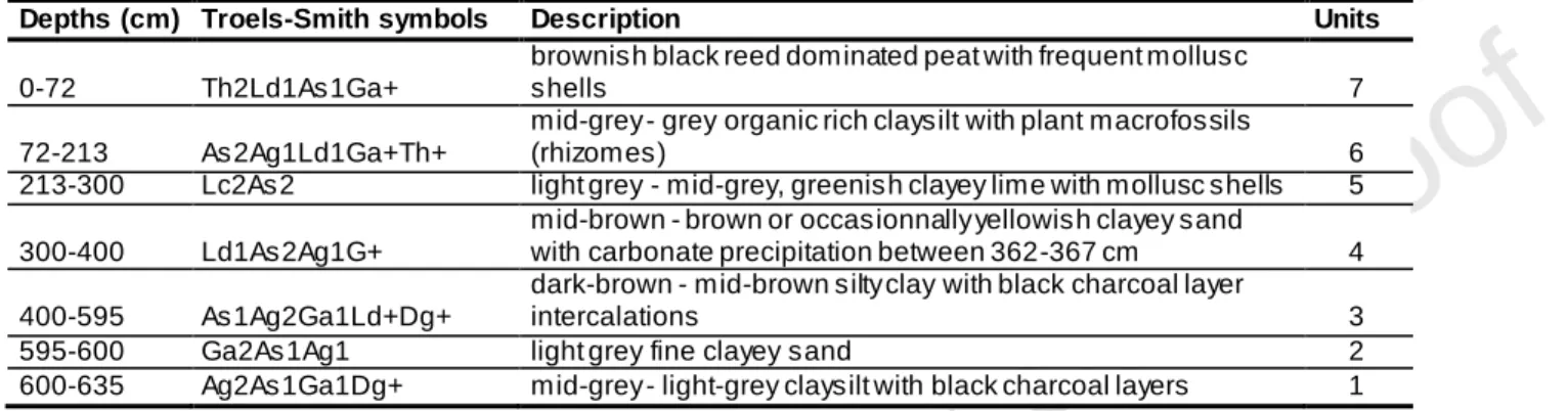
The 635 cm-long sediment core was taken in the centre of the mire (47°24’10”N, 21°55’43”E) in 2008. We used a Livingstone piston corer for the upper 600 cm and a Russian corer for the lowermost 40 cm. Sediment composition was described in the laboratory using the Troels-Smith system (Troels-Smith, 1955) (Table 1), cores were stored at 4°C.
“insert Table 1”
Chronology
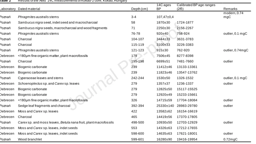
The chronological framework of the Kokad-2 core was established using a series of 23 AMS 14C age determinations at the Poznań Radiocarbon Laboratory (Poland) and at the Isotope Climatology and Environmental Research Centre (ICER, Debrecen, Hungary) (Table 2). The dating was made on plant remains (Phragmites australis stems, Cyperaceae leaves,
Carex sp. leaves, Betula nana fruit and Sambucus sp. seeds, wood fragments), macrocharcoal
particles and biogenic carbonate material, the latter taken between 239 and 279 cm (Table 2). All 14C ages were calibrated into calendar years using the Calib Rev. v. 7.0.4. software and the IntCal13 radiocarbon calibration curve (Reimer et al., 2013; Stuiver & Reimer, 1993). The age-depth model was constructed using the Bayesian method (Blaauw and Christen, 2013) with the BACON package in R (Figure 2). For testing the accuracy of our age-depth model, pollen results from Kokad and other sites as Nagymohos, Lake Fehér and Lake St Anne were also taken into consideration (see Appendix B).
Journal Pre-proof
Magnetic susceptibility, bulk density and organic content
Core segments were split into two halves in the laboratory. One core half was photographed, described, and used for magnetic susceptibility measurements (MSCL) with a core logger at 5-mm resolution. The other half core was cut continuously into 1-cm wide half cylinders. One cm3 sub-samples were taken at 2-cm intervals, dried at 105°C for 2 hours, followed by ignition at 550°C for 3 hours (Heiri et al., 2001). Wet weight, dry weight and weight loss-on-ignition (LOI) were determined and used to estimate bulk density and organic content.
Geochemistry and grain size analyses
Geochemical analyses were carried out to provide additional evidence for the physico-chemical changes in the mire as well as in the catchment area. Samples of 1-cm3 were taken at 4-cm intervals for major element analyses. The chemical extraction technique followed Berglund (1987) and Bengtsson & Enell (1986). A two-step extraction was used: first, dried samples were digested using 65% HNO3 at 80°C for 3h. The samples were treated with 35%
H2O2 and evaporated at 80°C. HNO3 (1%) was used to dissolve the extractants. For
completing the dissolution process, samples were placed into ultrasonic bath. Thereafter, samples were dried at 105°C, and then heated in closed reagent tubes at 105°C for 2h with 38% HF. After cooling, boric acid (5%) was added and the tubes were filled up to 10 ml using double de-ionised water. Element concentrations were measured using inductively coupled plasma atomic emission spectrometry (ICP-AES) at the ICER Laboratory, Debrecen
(Hungary). Results are presented in Figure 3.
Grain-size distributions were determined at 4-cm intervals with chemically pre-treated samples, following Buurman et al. (1996). The two-step treatment involved treatments with
Journal Pre-proof
sodium acetate solution (1M) and acetic acid (100%) to remove carbonates, and hydrogen peroxide (35%) to digest organic matter. Samples with high organic content were heated at 105°C for 2 h. All samples were measured at the Department of Environmental and Landscape Geography, Eötvös Loránd University, Budapest using a Horiba Partica LA950V2 laser particle-size analyser. The grain-size distributions were combined from the datasets using Blott & Pye (2012). For determining the silt/clay size class boundary the method of Eshel et al. (2004) and the Horiba Inc. (2012) was applied and the following classes were used: coarse sand >0.5 mm; medium sand 0.5–0.2 mm; fine sand 0.2–0.1 mm; very fine sand 0.01–0.05 mm; coarse silt 0.05–0.01 mm; fine silt 0.01–0.005 mm; clay <0.005 mm (Figure 3).
Mollusc analysis
During the plant macrofossil analysis, mollusc shells were selected and classified into ecological and biogeographical groups following Sümegi and Krolopp (2002). The fauna was divided into species requiring steady water cover (ditch group), species tolerant to periodic water supply (slum species), species living in water or in very moist environment (hygrophilous species) and species avoiding the extremes of moisture or dryness (mesophylous). Molluscs were also grouped according to their recent geographical distribution, and on the basis of their palaeoclimatological indicator role (Figure 4B and Table 4).
Plant macrofossil analysis
For plant macrofossil analysis 5-cm wide sub-samples (average volume 23 cm3) were taken contiguously. Samples were briefly soaked in 10% NaOH and wet-sieved through 250
Journal Pre-proof
µm mesh. Terrestrial and aquatic plant remains were picked out systematically from the residues under a stereomicroscope (Olympus SZ 51, at x10 magnification) and identified to the lowest possible taxonomic level using identification keys (Bojnanský & Fargašová, 2007; Haas, 1994; Katz et al., 1965, Schermann, 1967; Smith, 2004; Tomlinson, 1985; Velichkevich & Zastawniak, 2008) and by comparison with the reference collection of the MTA-MTM-ELTE Research Group for Paleontology.
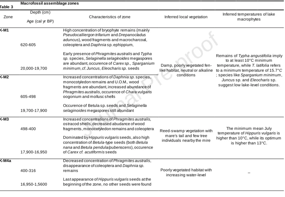
Sediment components (e.g. unidentifiable organic material (UOM), wood, macrocharcoal, unidentifiable leaf fragments (ULF), undifferentiated monocotyledon remains) were counted in 5 randomly chosen 1-cm2 squares in the Petri dish. Estimates were made of the relative frequency of the components amongst the indeterminate fossils, as leaf and bryophyte fragments (ULF, UBM), monocotyledons, macrocharcoal particles and unidentifiable organic material (UOM) following Jakab et al. (2004). Few samples from different sediment layers were selected to identify brown moss species. The concentrations of plant macrofossils were standardised to 40 cm3 sediment and diagrams were drawn using the TILIA software (Grimm, 1992). The plant macrofossil concentration diagram was divided into seven macrofossil assemblage zones (K-M1 to K-M7) visually taking into account major compositional and concentration changes.
The reconstruction of mean July temperatures relies on aquatic and terrestrial climate indicator-species extracted from the sediment. Their minimum and optimum mean July temperatures were previously published in Kolstrup (1980), Hannon & Gaillard (1997) and Schenk et al. (2018). These published temperature values were applied to the mean July temperature reconstruction at Kokad mire for the last 20,000 years.
Journal Pre-proof
For macrocharcoal analysis, 565 samples of 1 cm3 were taken contiguously, deflocculated and bleached using 10% (NaPO3)6 and 5% NaOCl and sieved through a 160 μm
mesh under a soft water jet following Genries et al. (2012). The residue was washed into a white porcelain-evaporating dish to aid identification of charcoal particles. The material was examined under a binocular microscope (Leica M80 at X60 magnification) equipped with a video camera. The WINSEEDLE image-analysis software (Regent Instruments Canada Inc., 2009) was used to count the macrocharcoal particles and measure their surface area. Charcoal concentrations (by number and by area) were transformed into charcoal influx (or accumulation rate, CHAR).
To reconstruct fire history, the CHARcount record was first interpolated to a constant
sediment-accumulation rate (CHARi) and thereafter decomposed into the background
(CHARbackground) and peak (CHARpeak) components. The CHARbackground should reflect
regional biomass burning and secondary charcoal deposition, and CHARpeaks record should
reflect local fire episodes. The CHARbackground was modelled as a locally-weighted regression
(lowess regression) with 1000-year time window, which was found to maximise the signal-to-noise ratio (SNI) (Kelly et al., 2011). The CHARpeak component was obtained by subtracting
the CHARbackground from CHARi. CHARpeak values exceeding the 90th percentile threshold of
the modelled local-noise distribution were identified as potential fire episodes (CHARfire).
These were finally screened using the minimum-count test (Higuera et al., 2010). We used the distribution of fire return intervals (years per fire; FRIs) for the LGM (20,000–15,000 cal yr BP) and the late Holocene (4000–0 cal yr BP) to characterise the temporal characteristics of fire regimes for each of these time periods. FRI distributions were described by the mean and median FRI (FRImean and FRImedian, respectively). We tested whether the smoothing window
width had an influence on FRIs using Weibull test, as implemented in the CharAnalysis software (Higuera et al., 2009).
Journal Pre-proof
Results
“insert Figure 2”
Chronology
Of the 23 14C age determinations (Table 2) five samples (4 cm, 78 cm, 123 cm, 244 cm and 601 cm) contained very low amount of carbon, and three of them were considered to be outliers according to the Bayesian model (Figure 2). Many of these five 14C ages showed younger ages than expected probably due to low carbon content and consequent contamination by modern CO2 during the dating. These younger dates generally originate
from samples with small sample weight and large surface area.
For running the age-depth model (Figure 2) the surface of sediment was determined -58 cal yr BP old (AD 2008), while the bottom of the studied sediment section is around 20,000 cal yr BP (Figure 2). Nine 14C dates were identified as outliers in this model (Table 2). The age-depth model suggests the lowest sediment deposition times (average 14 yr cm-1) between 20,000 and 15,000 cal yr BP (275–635 cm) for the predominantly clayey-silty sediment with occasional sand and charcoal layers, then slower deposition with larger deposition times (average 59 yr cm-1) between 15,000 and 3400 cal yr BP (100–275 cm) for the grey–greenish clayey lime. Sediment deposition times decreased (average 32 yr cm-1) for the brownish peat in the top 100 cm (last 3400 years) suggesting more rapid sediment accumulation.
An alternative age-depth model was also developed, which excluded the less reliable bulk sediment dates and therefore gave significantly younger ages during the Early Holocene section of the core. Our actual chronology is supported by two significant marker horizons in
Journal Pre-proof
the pollen record (Appendix B). The rapid decrease of Cyperaceae (both pollen and macrofossils) together with the decline in Fe, Mn, Ca concentrations, and major decrease in fine sand content at around 16,200 cal yr BP coincide well with detected climate and ecosystem changes at other sites and various loess records (Sümegi, 2005), the Black Sea sediment (Kwiecien et al., 2009; Major et al., 2006; Sanchi et al., 2014), and Lake St Anne (Magyari et al., 2014a, 2019 under revision; Tóth et al., in prep) and even Southern Alps sediment records (Tinner et al., 1999) indicate rapid ecosystem reorganization at that time. The other pollen horizon marks the onset of Holocene around 11,700 cal yr BP, when the rapid pollen percentage increase of Ulmus, Quercus and Corylus is generally noticeable in this region (Appendix B).
“insert Figure 3”
Sediment lithology, organic content and magnetic susceptibility
Seven lithostratigraphic units were determined in the 635-cm long core (Table 1, Figure 3 & 4AB). Sediments comprising the lowermost two units (635–600 cm and 600–595
cm; 20,000–19,500 cal yr BP) were deposited directly after the last glacial maximum (LGM), in the Late Pleniglacial period (~GS-2.1; Rasmussen et al., 2014). The sediment is grey clayey silt with frequent black, seemingly burnt layers. This is followed by darker, brownish coloured silty clay between 595 and 400 cm (19,500–16,500 cal yr BP) and mid-brown clayey sandy silt with occasional carbonate precipitation (400–300 cm; 16,500–15,300 cal yr BP). Organic content values are low at the bottom, between 3 and 6%, with two moderately higher peaks (c. 11%) at 458 cm and 484 cm (17,500 cal yr BP and 17,100 cal yr BP) (Figure 3), then further decrease above 400 cm to <5% until the Holocene. The fifth unit represents the Lateglacial (300–213 cm; 15,300–10,800 cal yr BP) and the sediment is lime rich clay with
Journal Pre-proof
abundant mollusc shell remains. The clayey silt unit between 213 and 72 cm (10,800–2300 cal yr BP) represents the majority of the Holocene with higher organic content (increase up to 21% at 151 cm; 6100 cal yr BP) and rich in plant remains. Finally, the top unit (72–0 cm; 2300 cal yr BP to present) is blackish brown reed-swamp peat rich in mollusc shells, and organic content reaches maximum value of 88% at 50 cm (1600 cal yr BP).
Magnetic susceptibility (MS, Figure 3) values are very low between 542 and 468 cm (18,500–17,500 cal yr BP). Strongly fluctuating and high values occur between 468 and 422 cm (17,500–16,800 cal yr BP) suggesting increased input of magnetic minerals with strong variation, then a gradual decrease starts from 16,800 cal yr BP (422 cm) although values still strongly fluctuate until 361 cm (16,100 cal yr BP). Between 361 and 243 cm (16,100–13,600 cal yr BP) MS values are still relatively high, but show a gradual decreasing trend. Lowest MS values were recorded above 243 cm (<13,600 cal yr BP) (Figure 3). MS values increase modestly around 149 cm (6000 cal yr BP), show increases at 118 cm (3900 cal yr BP) and moderately elevated values occur between 77 and 64 cm (2400–2000 cal yr BP). Finally, MS values re-increase slightly in the topmost 10 cm, which covers the last c. 300 years.
Major element and grain-size analyses
The results of the geochemical and grain-size analyses show (Figure 3) that both Fe and Mn concentrations are relatively high and fluctuate from the bottom of the core to 320 cm (20,000–15,700 cal yr BP). High percentages of coarse silt and very fine sand characterise this interval together with strong fluctuation in the MS curve. At 365 cm (16,170 cal yr BP) both Fe and Mn show peak concentrations while organic content shows a small increase together with the increase of Ca, the sudden decrease in coarse silt and very fine sand content that is compensated by an increase in fine silt. Since neither medium sand, nor MS and Ca
Journal Pre-proof
values return to the previous level, and the sediment composition also changes (from 16,500 cal yr BP), these abrupt changes are likely indicative of a rapid environmental shift involving the accelerated input and precipitation of Ca in the lake and less intense erosion. Ca values show steep increase again at 292 cm (15,280 cal yr BP). Significantly higher coarse silt and fine silt values characterise the core from 375 cm (16,300 cal yr BP) to the top with many fluctuations (decreases in coarse fraction at 300 cm (15,400 cal yr BP); 220 cm (11,570 cal yr BP); 125 cm (4280 cal yr BP); 100 cm (3400 cal yr BP); 75 cm (2370 cal BP); 50 cm (1600 cal yr BP). Fe/Mn ratios start to decrease from 370 cm (16,200 cal yr BP); this decrease is mainly attributable to the selective increase of Mn between 290 and 220 cm (15,250–11,560 cal yr BP) that is accompanied by massive increase in Ca and modest increase in S concentrations. High Ca values suggest strong biogenic carbonate precipitation between 292 and 206 cm (15,250–10,040 cal yr BP). The upper 75 cm (last 2400 years) is characterised by prominently high S values simultaneously with maximum values of organic content and strongly fluctuating but high Ti values (at 55 cm with absolute maximum). These records suggest that the detected peak of coarse sand at 50 cm (c. 1600 cal yr BP) might be an error during the grain-size measurement, where clumped organic debris was probably measured.
Plant macrofossil and mollusc analyses
“Insert Figure 4A and 4B”
High concentration of woody fragments (mainly Betula sp. remains), ostracod, Coleoptera, bryophyte remains (mainly Pseudocalliergon trifarium and Drepanocladus
aduncus) and Daphnia magna and D. pulex ephippia characterise the bottom of the sediment
between 635-605 cm (zone K-M1; 20,000-19,700 cal yr BP; Figure 4A and 4B, Table 3).
Journal Pre-proof
cm (c. 19,900 cal yr BP). In addition, seeds of several wetland species occurred, such as
Carex sp., Sparganium minimum, cf. Juncus and Eleocharis sp. Megaspores of Selaginella selaginoides were also abundant in this early stage.
The continuous presence of Phragmites australis rhizomes was detected from 524 cm (c. 18,300 cal yr BP) in zone K-M2 (605–500 cm, 19,700–17,900 cal yr BP). Daphnia
magna/D. pulex ephippia, monocotyledon remains and woody fragments were also abundant
in this interval. Occasional occurrence of Betula sp., Potamogeton natans and T. angustifolia seeds was typical in this zone, while megaspores of S. selaginoides disappeared at 518 cm (18,200 cal yr BP). Macrocharcoal particles counted among the plant remains (Figure 4A) showed fluctuating values from zone K-M2 to K-M4a. However, non-charred woody fragments were abundant in macrofossil assemblage zones K-M1 and K-M2 (Figure 4A). Aquatic mollusc species, such as the ubiquitous Planorbis planorbis support an increase in water-level in this zone (c. 19,000 cal yr BP; Figure 4B).
From 17,900 cal yr BP (zone K-M3; 500–400 cm) ostracod shells became abundant, while the concentration of macrocharcoal and woody fragments decreased. Remains of
Daphnia sp. disappeared from the record at 433 cm (c. 17,000 cal yr BP). The dominance of P. australis and Hippuris vulgaris characterised this interval until 16,600 cal yr BP (400 cm).
Seeds of Betula nana, Betula cf. B. pendula/pubescens, needle bases of Pinus sp. and Carex
cf. C. acutiformis occurred. From 400 cm (zone K-M4a; c. 16,600 cal yr BP), the sediment
contained less macrofossils until 200 cm (c. 9500 cal yr BP). The concentration of P. australis vegetative remains was also low in this period, while wood fragments disappeared. Simultaneously with the low concentration of plant remains, high concentration of mollusc shells and the presence of Chara vulgaris oogonia can be noted in subzone K-M4b (315–210 cm, 15,600–10,500 cal yr BP) that represents the Lateglacial and the earliest part of the Holocene.
Journal Pre-proof
The abundance of P. australis increased again in zone K-M5 (210–120 cm, 10,500– 3950 cal yr BP). This zone encompasses the early and mid-Holocene, when sediment accumulation rates were very low (Figure 2). Chara vulgaris and Tolypella prolifera concentrations peaked at 130 cm (4700 cal yr BP). Rhizomes of Typha sp. were also found in low abundance. From 125 cm (c. 4200 cal yr BP) the sediment contained more plant remains:
Daphnia sp. ephippia, Typha sp. (both T. angustifolia and T. latifolia) and Potamogeton natans seeds re-appeared. The next zone boundary was drawn at 3950 cal yr BP (zone K-M6;
3950–1700 cal yr BP), when the above mentioned taxa became even more abundant, and new taxa, such as Sambucus nigra, Urtica dioica and cf. Cyperus sp. remains also appeared in high concentration, while Eupatorium cannabinum appeared in low rate.
The topmost part of the sediment sequence (K-M7; from 1700 cal yr BP) is characterised by high concentration of P. australis and Typha sp. rhizomes. T. angustifolia seeds became dominant, while S. nigra decreased. Remains of E. cannabinum were still present, while seeds of Rumex hydrolapathum and Myriophyllum spicatum appeared in the top 50 cm of the core. Mollusc elements preferring more eutrophic conditions, such as
Valvata cristata and Segmentina nitida were detected at 1400 cal yr BP. Other mollusc
species indicative of terrestrial habitats (as thermophilous Vallonia enniensis and mesophylous V. pulchella) were more abundant in zone K-M7 (last 1300 years) likely indicating lower water-level and drier conditions in and around the mire (Figure 4B). Wet-damp habitat preferring species such as Carychium minimum, Succinella oblonga and
Zonitoides nitidus were also detected in the upmost macrofossil zone.
“insert Table 3” “insert Table 4”
Journal Pre-proof
Fire-history reconstruction
Both charcoal concentration and CHARbackground values are very low or charcoal
fragments were absent in samples between 15,200 and 4200 cal yr BP. Charcoal concentration and CHARbackground values were instead substantially higher prior to 15,200 and
after 4200 cal yr BP, suggesting high biomass-burning rates during the LPG and the late Holocene. In keeping with this, high peak-magnitude values as well as significant charcoal peaks cluster in the LPG and the late Holocene. Fire-episode frequency reached higher values in the LPG (up to 4 fire episodes 1000 yr-1) than in the late Holocene (up to ca. 2 fire episodes 1000 yr-1). To check if the FF values were significantly different, minimum count P tests were applied and set to 0.05. To test whether the change of smoothing window width has any influence on FRIs we used Weibull test: the mean FRIs in Zone 1 are consistently longer than in Zone 3. During the past 4000 years the FRIs were shorter than during the LPG. However, the 95% confidence-interval distributions of the FRIs within the two zones overlap, the difference is possibly minor.
During the late Holocene, CHARbackground values peak twice (at ca. 3500 cal yr BP and
at ca. 1500 cal yr BP), indicating two distinct biomass-burning phases (Figure 5). The peak around 3500 cal yr BP overlaps with the maximum concentrations of Typha sp. and Sambucus
nigra remains. While around 1500 cal yr BP only Typha angustifolia and T. latifolia were
frequent, the organic content reached its maximum earlier, around 1600 cal yr BP. The last 4200 years were characterised by higher biomass-burning rates, although the wood fragments only became abundant later, during the last 2000 years in the sediment.
“insert Figure 5”
Journal Pre-proof
Macrofossil -inferred climate, vegetation and environmental conditions during the last
20,000 years
“insert Table 5” “insert Figure 6”
For reconstructing the evolution of mire and lake succession, individual indicator taxa were used, focusing on their minimum and optimum July mean temperatures (Table 5). Although this method previously provided valuable information for Northern European records (e.g. Väliranta et al., 2015) and in the global climate simulations for the Younger Dryas (Schenk et al., 2018), we had relatively few July temperature indicator taxa in the Kokad plant macrofossil record with specific ecological requirements: Hippuris vulgaris,
Myriophyllum spicatum, Myriophyllum verticillatum, Typha latifolia, T. angustifolia, Potamogeton sp., Littorella sp. and Betula species as B. nana, B. pendula and B. pubescens.
As we will see in the discussion below, our mean July temperature reconstruction based on the presence/absence of these species is limited due to the minimum July temperature requirements of these species that were likely often exceeded in the LPG period. This is because the Great Hungarian Plain was situated in the periglacial zone with continental climate throughout the LPG involving relatively warm summers even during maximum cooling as inferred from loess mollusc assemblages (Sümegi & Gulyás, 2004; Sümegi, 2005). Therefore, the aquatic indicator taxa with minimum July mean temperature requirements ranging 10–16.1°C are within a range that was exceeded relatively early during the LPG and LG (Lateglacial) warming stages.
Journal Pre-proof
At the onset of the mire formation, between ca. 20,000 and 18,000 cal yr BP the possible presence of the heliophilous and cold-tolerant shrub, Betula nana, and lesser clubmoss (Selaginella selaginoides) megaspores suggest damp, poorly vegetated fen-like habitats on the lakeshore. This inference is also supported by the presence of brown mosses:
Pseudocalliergon trifarium is typical in base-rich northern mires today, more rarely over wet
rock slabs and in mountainous areas mainly in montane and Northern Europe (Atherton et al., 2010; Hedenas, 1994; Smith, 2004), while Drepanocladus aduncus is a species locally abundant in lowland ditches and fens in Northern Europe, mainly in clayey areas (Atherton et al., 2010) and often in areas where the ground water is base-rich and eutrophic (Hedenas, 1994; Smith, 2004). Their presence support the presence of fen habitats. S. selaginoides often occurs together with shrub Betula species in arctic and high alpine habitats today (Eurola et al., 1984). Their co-occurrence indicates that in the Kokad area neutral or alkaline tundra-like wet-ground habitats were characteristic directly after the last glacial maximum (LGM). Remains of Betula species became frequent between 18,000 and 16,600 cal yr BP, while remains of Pinus sp. were only detected during this early phase, implying to their local presence. During the early LPG, the development of boreal forest-steppe vegetation was also detected at the nearby Bátorliget (Figure 1) with the regional presence of Pinus sp. (Sümegi and Juhász, 2004). Boreal woodland expansion was also recorded around 19,000 cal yr BP at Lake Fehér (south of Kokad mire) with Pinus Dyploxylon-type and Picea abies together with broadleaved species (Sümegi et al., 2013). These findings are in line with our Betula sp. and
Pinus sp. remains despite the distance of 170-km between the sites. Other palaeobotanical
evidences confirmed mosaic-like pattern of the environment by charcoal pieces of Picea,
Pinus cembra and Larix (Rudner and Sümegi, 2001; Sümegi and Gulyás, 2004), while Betula
remains were also recovered shortly after the formation of Lake Balaton between 17,000– 16,000 cal yr BP (Jakab et al., 2005).
Journal Pre-proof
The reconstructed damp, fen-like habitat had similar characteristics as Nagymohos (NE-Hungary, Figure 1) (Magyari et al., 1999). Both sites supported boreal brown moss (Pseudocalliergon trifarium and Drepanocladus aduncus) and sedge communities, although Nagymohos was more alike the boreal region of Northern-Europe, where pines with rich herb vegetation dominate on mire surfaces (Eurola et al., 1984). The appearance of Sphagnum species (Sphagnum cf. cuspidata and S. palustre) indicated sub-arctic to boreal climate at Nagymohos, where the mean annual temperatures were > -6 - -9°C with annual precipitation of >300mm (Gignac et al., 2000). These values characterise the northern distribution limit of
Sphagnum dominated peatlands in continental North America according to Gignac et al.
(2000).
The presence of the floating-leaved macrophyte, Potamogeton natans, furthermore suggests increasing water depth at Kokad; this species frequently occurs in habitats with 2–6 m depth (Gaillard, 2007; Hannon and Gaillard, 1997a), but usually tolerates water-depth down to 1.5 m (Newman, 2014). Its presence is generally associated with higher water depth (Jakab et al., 2009b), and in still or slowly moving water (Gupta, 2013). We detected its presence since 19,300 cal yr BP. Carex sp. and Eleocharis sp. likely grew in the shallower marginal zone of the lake, likely together with Sparganium minimum, which can tolerate water-depth up to 3 m (Gaillard, 2007). Potamogeton species require at least 11.7°C July mean temperature (Table 5), while Sparganium sp. requires at least 10°C (Schenk et al., 2018).
The high concentrations of Daphnia magna/D. pulex ephippia and ostracod shells also support the presence of a calcareous shallow lake at the core location during zones KM-4 and KM-3. Daphnia magna can tolerate high water temperatures up to 25°C and low oxygen concentration better, than D. pulex (Wojtal-Frankiewicz, 2012). According to Isarin & Bohncke (1999), the presence of Ranunculus sect. Batrachium remains suggests mean July
Journal Pre-proof
temperatures >10°C, while Typha latifolia is also an important climate indicator in this zone, it requires >13°C July mean temperatures according to Kolstrup (1980) and Gaillard (1984, 2007), while Schenk et al. (2018) suggest at least 15.7°C. Increasing Typha sp. pollen percentages were already detected from 25,000 cal yr BP at Lake Fehér (Sümegi et al., 2018), and seeds were discovered from 17,470 cal yr BP in Lake Balaton (Jakab et al., 2005).These findings together with the results of climate model simulations (15–17°C by Renssen et al. (2001)) support our relatively warm July mean temperature inferences and also warn us that the minimum thermal tolerance requirements of aquatic taxa were already exceeded in the lowland areas during the early LPG period.
The early and continuous presence of Phragmites australis rhizomes in the sediment indicates the development of lakeshore reed-swamp vegetation from c. 18,300 cal yr BP or somewhat later if we assume down-core penetration of Phragmites rhizomes and sediment compaction. Phragmites australis together with Hippuris vulgaris became dominant from ~18,000 cal yr BP until 16,500 cal yr BP. Reed tolerates a wide-range of water-depths, from damp surface up to 2 m (Gaillard, 2007; Hannon and Gaillard, 1997a), while Hippuris was also part of the first pioneer plant communities in Switzerland, although became dominant rather later, around 15,100 cal yr BP when July temperatures increased to more than 13°C (Gaillard, 2007; Hannon and Gaillard, 1997a). Its optimum July mean temperatures are higher than 13°C, while its minimum is >10°C (Gaillard, 1984; Kolstrup, 1980). Nowadays, in the Great Hungarian Plain H. vulgaris prefers shallower streambanks and ponds with fluctuating water-level (usually more than 1 m deep) and alternating nutrient supply. It occurs together mostly with small, less competitive marsh species (Bölöni and Kun, 2011). For Hippuris the temperature is not a crucial factor, it grows in meso- and eutrophic waters with low species competition (Misson et al., 2016), but it is also found in more alkalitrophic waters (Rybníček and Rybníčková, 1968). Hippuris prefers habitats high in Ca, and also enters plant
Journal Pre-proof
communities of Phragmition, Nymphaeion, Ranunculion fluitantis and Littorellion (Rybníček and Rybníčková, 1968). Overall, the plant macrofossil record suggests shallow, alkaline water conditions, similarly to Kołaczek et al. (2015) and a floating brown moss carpet typical of the northern boreal zone between 18,000 and 16,500 cal yr BP.
Our results point to cooling within the Hippuris dominated zone (K-M3) as the timing of the significant decline in Cyperaceae remains both in macrofossil (Figure 4a) and pollen percentages (Appendix C) around 16,200 cal yr BP coincide with the changes of Fe, Mn and Ca concentrations and the decline in fine sand content and together indicate ecosystem and climate change at Kokad mire. This interval broadly agrees with Heinrich event-1 (HE-1: 17,850–16,200 cal yr BP). Although aquatic remains were scarce in the sediment during this interval, available pollen results suggest arboreal pollen decline (Magyari et al., 1999) and the expansion of Juniperus at mid altitudes in the Carpathians against Pinus sylvestris (Magyari et al., 2014b) that also supports cooler and drier conditions.
Significant changes in the local vegetation occurred at the beginning of zone K-M4a , around 16,500 cal yr BP. The disappearance of Daphnia ephippia and ostracod shells and decreased concentration of U.O.M. and monocotyledon remains suggested that the core location became less vegetated, likely a pelagic habitat without submerged or emergent macrophyte cover, therefore the water-depth probably increased. This inference is also supported by decreasing LOI values at the KM-3/KM-4a boundary (Figure 3), while the decline of Mn and the increase of Ca suggest changes in the catchment area. The increase of Fe and Mn are also followed by an increase of Ca, which probably reflect the development of podzol soil (Fe and Mn leaching), while Ca likely derived from the chemical weathering of the loess and Ca-rich alluvial sediments. Oxygen availability at the sediment/water interface can be inferred from the concentration changes of Fe and Mn (Figure 3), as their redox cycling depends on oxygen availability at the sediment–water interface in lake and mire
Journal Pre-proof
ecosystems (Mackereth, 1965). Podzol soils release Fe to the lake and precipitaton of Fe compounds might suggest lower pH conditions in the lake. The increasing concentrations of Fe and Mn may suggest the development of acidic soils in the catchment and oxidative conditions at the sediment-water interface.
Shortly after this significant change, Ca values began to rise at 365 cm (16,170 cal yr BP) and seeds of aquatic plants disappeared from the record, while P. australis vegetative remains were still present, although in decreased concentration until the beginning of the Holocene. Simultaneously with the Ca increase, Fe and Mn concentrations also attained maxima temporarily at 16,170 cal yr BP, pointing to a substantial change in the lake environment. The grain size decrease implies that erosion from the lakeshore suddenly halted, and oxidative conditions at the sediment-water interface likely prevailed. The organic content of the sediment also increased in this short interval together with increasing concentration of wood and leaf remains. Overall, these features suggest an episodic lake-level decrease followed by a generally lower energy environment in which erosion rates decreased steadily, but the water level likely restored.
According to the geochemical record, the interval between 15,300 cal yr BP and 10,000 cal yr BP was dominated by the precipitation of biogenic carbonate, where the sediment became grey to greenish clayey lime silt. The deposition of biogenic carbonate was initiated in two steps: first around 16,170 cal yr BP, then secondly with a steep increase in Ca values from 15,300 cal yr BP. During the major carbonate formation interval, the lacustrine system was likely characterised by increased water-level. The timing of the biogenic carbonate formation at Kokad mire (15,200 cal yr BP) preceded substantially by 3000 years, other similar events identified within the GHP (Cserny and Sümegi, 2003; Jenei et al., 2007; Sümegi et al., 2011, 2013a; Sümegi and Gulyás, 2004; Willis et al., 1995). The high abundance of Chara sp. oogonia together with the increased ostracod remains in the sediment
Journal Pre-proof
indicate a freshly emerging calcium-rich, but nutrient-poor open lake with increased water-depth. The dominant species, Chara vulgaris prefers alkaline conditions and tolerates well poor nutrient supply (Haas, 1994). These conditions characterised the LG interstadial, with a shift to slightly increased in-lake productivity after 13,600 cal yr BP. The macrofossil assemblages were species-poor in this period and did not display any change during Greenland Stadial 1 (GS-1) that broadly equals with the Younger Dryas cooling between 12,800-11,700 cal yr BP. The scarcity of plant remains at Kokad mire does not allow us to make any inference on the terrestrial vegetation change during the LG period. Regionally gradual expansion of hardwood gallery forests were detected with sporadic occurrence of P.
sylvestris and Picea around Bátorliget (Sümegi and Juhász, 2004), where Tilia became
dominant (Willis et al., 1995). Chironomid-based July mean temperature reconstruction from the South Carpathians revealed an increase in July mean temperatures by 2.8°C at 14,700 cal yr BP (Tóth et al., 2012), meanwhile pollen data pointed to 16–17°C July mean temperatures in the Romania Carpathians at altitudes 800-900 m a.s.l. (Feurdean et al., 2008).
The early and mid-Holocene was characterised by the dominance of Phragmites
australis at Kokad between 10,000 and 4000 cal yr BP, then Typha species also became
frequent. The spread of Typha angustifolia and T. latifolia started at c. 12,200 cal yr BP (during the Younger Dryas period). The maximum concentrations of Chara vulgaris and
Tolypella prolifera at c. 4700 cal yr BP indicated decreasing water-depth at Kokad mire, but
still relatively poor nutrient supply, as the latter taxa tolerate water-depth up to maximum 3 m (Haas, 1994). The shallower water-depth conditions are also supported by the mollusc species
Valvata cristata and Planorbis planorbis.
From 4000 cal yr BP, the appearance and high abundance of Sambucus nigra indicates nutrient enrichment and further shallowing of the lake and simultaneously with the increase in sulphur (S) concentration indicates peat formation and the lake-ward expansion of the
Journal Pre-proof
mire/swamp vegetation. The core location turned into reed swamp around 2000 cal yr BP, when the organic content increased to ~80%. Between 3800 and 2000 cal yr BP Cyperus remains were found that suggests seasonal desiccation of the lake/mire shore in this period. The remains of the mollusc fauna consisted of many terrestrial and aquatic habitat species in the upper zones, suggesting periodic water coverage over some areas of the mire. The appearance of Urtica dioica also supported reed swamp spread to the coring location and increasing nutrient availability likely on seasonally dry areas. The further expansion of
Phragmites australis and Typha sp. indicate warmer conditions and refer to infilling of the
lake basin since 4000 cal yr BP, the increased CHAR values probably imply a higher biomass burning period during the last 4000 years, probably due to human presence in the area.
P. australis, Typha latifolia and T. angustifolia dominated the last 1700 years
suggesting continuing reed-swamp vegetation with further increasing organic productivity and accumulation. According to Grace & Wetzel (1981), T. angustifolia is capable to grow under higher water-depth, and the competition between the two species (T. latifolia and T.
angustifolia) results in that the latter taxon is restricted to depths less than 80 cm, while the
other is present along the entire 2-m long gradient. P. australis and T. angustifolia are both competitive species, P. australis grows higher and easily overshadows and out competes T.
angustifolia under favourable conditions (Jakab et al., 2009). However, P. australis requires
coarser sediment, while T. angustifolia settles in finer-grained sediment to anchor its roots (Haslam, 1972; Nurminen, 2003; Toivonen and Back, 1989). The presence of all three taxa suggest that the reed swamp had mosaic like surface pattern, with deeper and shallower habitats and varying sediment types that resulted in the presence of all three taxa. Seasonal water-depth fluctuation was likely of large-amplitude similar to the situation today.
In the topmost 54 cm (last 1700 years) the colonisation of Rumex hydrolapathum occurred, that indicates the terrestrial phase of the mire development. The occurrence of
Journal Pre-proof
Valvata cristata and Segmentina nitida molluscs in high abundance around 1500 cal yr BP
also support the transition to mesotrophic conditions (Sümegi et al., 2013). The seeds of R.
hydrolapathum germinate on waterlogged soils suggesting that the reed swamp was under
water during the last 1700 years. The species also requires temperatures above 15ºC for germination (Van Assche et al., 2002). Urtica dioica and R. hydrolapathum are likely reflecting intensified human activity in the area. Sambucus nigra decreased, it was probably restricted to farther habitats from the coring point during this last phase.
The presence of Myriophyllum spicatum in this final phase of the wetland succession point to the presence of shallow open water patches within the reed swamps. The decline in
Chara oogonia along with the presence of M. spicatum furthermore suggests the development
of shallow eutrophic mire conditions. The presence of Galba truncatula also refers to ditches, spring swamps and reeds (Knubben-Schweizer and Torgerson, 2015) in parallel with swampy, humid habitat preferences of Zonitoides nitidus and Carychium minimum (Kurzawska and Kara, 2015). Remains of Eupatorium cannabinum were found frequently together with other tall herbaceous dicotyledonous remains (e.g. Epilobium hirsutum) that usually live in Phragmites australis dominated species-poor habitats (Moore et al., 1984).
Fire history in the Northeastern part of the Great Hungarian Plain
We found that both biomass-burning rates and fire frequencies were higher during the LPG than during Holocene in the Great Hungarian Plain (Figure 5), when Pinus sp. and
Betula species were present around Kokad mire (Figure 4A & 4B). This finding is at odds
with the notion that fire activity was globally lower during the LGM and LPG than during the Holocene due to colder and drier climates, lower than present atmospheric CO2 concentration,
Journal Pre-proof
and lower fuel availability (both woody and herbaceous) (Carcaillet et al., 2009; Harrison & Prentice, 2003; Lawson et al., 2013; Power et al., 2007). However, there are other records supporting the view that scattered tree populations persisted in East-Central Europe during the last glacial and Lateglacial that burnt regularly even during the LPG (Björkman et al., 2003; Feurdean et al., 2013; Willis et al., 2000, Willis & Van Andel, 2004; Wohlfarth et al., 2001). For instance, charcoal records from the GHP and the Carpathians indicate high fire activity between 23,000 and 20,000 cal yr BP, 18,000–16,000 cal yr BP (Lake Fehér; Magyari et al. 2014a; Sümegi et al., 2013;) and between 23,000 and 19,500 cal yr BP (Lake St Anne; Magyari et al., 2014b). Moreover, the abundance of microcharcoal particles during the LPG and around 17,500 cal yr BP at Nagymohos also support the intensive fire activity (Magyari et al., 1999).
The reconstructed fire history at Kokad between ca. 15,000 and 4000 cal yr BP differs, however, substantially from other records of the GHP and the Carpathians. At Kokad, biomass-burning rates and fire frequencies were very low during this time interval. Instead, other records indicate that this period was marked by substantial fire-activity changes. For instance, at Lake St Anne higher fire activity was recorded between 15,000 and 8000 cal yr BP (Magyari et al., 2014b), and enhanced fire activity periods during the warm intervals of the Lateglacial (between 14,000 and 12,700 cal yr BP) were associated to the spread of boreal trees in East-Central Europe (Feurdean et al., 2007; Magyari et al., 2012; Willis et al., 1997). In contrast to this, the expansion of hardwood gallery forests including Quercus sp., Ulmus sp., Corylus and Carpinus betulus were detected at Bátorliget with the association of the coniferous Pinus sylvestris (Sümegi & Gulyás, 2004). According to Tinner et al. (2000),
Quercus sp. represent a fire-indifferent class, which is not influenced by fire frequency, the
presence of Corylus is favoured by fire while Ulmus sp. is slowly damaged and could be locally extinct by fire. The recorded low fire frequency at Bátorliget could be the sign of
Journal Pre-proof
easily burning conifers than deciduous trees (Johnson, 1995). The lime-rich lateglacial sediments of Kokad contained only plant remains of Phragmites australis, indicating the presence of a reed belt around the mire. This might have contributed to reducing the input of macrocharcoal particles to the mire via secondary dispersal. Around Kokad, the pollen record revealed conifer dominated forest with cold deciduous elements and grassland between 14,000 and 12,700 cal yr BP (Magyari et al., 2019 under revision).
The low early-Holocene biomass-burning rates at Kokad also substantially differ in comparison with other records from Europe (e.g. Carcaillet et al., 2002; Finsinger et al., 2006; Lawson et al., 2013; Power et al., 2007; Rius et al., 2012; Tinner et al., 1998) and from Eastern-Central Europe (Feurdean et al. 2012a; Finsinger et al. 2018, 2014; Feurdean et al.,
submitted) that indicate high fire frequency during the Early Holocene. Generally, the
increasing fire activity in the early Holocene coincides well with the rise of atmospheric CO2
(Harrison and Prentice, 2003) and high summer insolation (Berger and Loutre, 1991). The early Holocene low fire activity at Kokad possibly indicates the low burning potential of the temperate wooded steppe vegetation that developed in the early Holocene around Kokad mire (Magyari et al., 2019 under revision). An alternative, or additional, explanation can be the peculiar location of the site. The Érmellék region is rich in wetlands today (Figure 1). During the early Holocene, this landscape was possibly rich in reed swamps and shallow calcareous lakes and was likely characterised by high groundwater table. These factors might have reduced fire-ignition risk and fire spread.
According to Feurdean et al. (2012) charcoal values in East-Central Europe decreased between 8000 and 5500 cal yr BP. This decline in fire activity is closely connected to strongly declining summer insolation and increasing winter insolation (Berger and Loutre, 1991). Drier conditions were reconstructed in the GHP between 7500 and 6400 cal yr BP (Jakab and Sümegi, 2011) that reflected later at Kokad, around 6500 cal yr BP. Charcoal abundances