Publisher’s version / Version de l'éditeur:
Géographie Physique et Quaternaire, 33, 3-4, pp. 299-316, 1979
READ THESE TERMS AND CONDITIONS CAREFULLY BEFORE USING THIS WEBSITE. https://nrc-publications.canada.ca/eng/copyright
Vous avez des questions? Nous pouvons vous aider. Pour communiquer directement avec un auteur, consultez la première page de la revue dans laquelle son article a été publié afin de trouver ses coordonnées. Si vous n’arrivez pas à les repérer, communiquez avec nous à PublicationsArchive-ArchivesPublications@nrc-cnrc.gc.ca.
Questions? Contact the NRC Publications Archive team at
PublicationsArchive-ArchivesPublications@nrc-cnrc.gc.ca. If you wish to email the authors directly, please see the first page of the publication for their contact information.
NRC Publications Archive
Archives des publications du CNRC
This publication could be one of several versions: author’s original, accepted manuscript or the publisher’s version. / La version de cette publication peut être l’une des suivantes : la version prépublication de l’auteur, la version acceptée du manuscrit ou la version de l’éditeur.
Access and use of this website and the material on it are subject to the Terms and Conditions set forth at
Permafrost existence and distribution in the Chic-Chocs Mountains,
Gaspesie, Quebec
Gray, J. T.; Brown, R. J. E.
https://publications-cnrc.canada.ca/fra/droits
L’accès à ce site Web et l’utilisation de son contenu sont assujettis aux conditions présentées dans le site LISEZ CES CONDITIONS ATTENTIVEMENT AVANT D’UTILISER CE SITE WEB.
NRC Publications Record / Notice d'Archives des publications de CNRC:
https://nrc-publications.canada.ca/eng/view/object/?id=278bc447-9cf0-4261-a0a3-801088b7e59e
https://publications-cnrc.canada.ca/fra/voir/objet/?id=278bc447-9cf0-4261-a0a3-801088b7e59e
Ser
TH1
N21a
no.
911
cop.
2 LLLJ5. -- I 4 1National Research
Conseil national
+
Council Canada
de
recherches Canada
PERMAFROST EXISTENCE AND DISTRIBUTION IN THE
CHIC-CHOCS MOUNTAINS,
GASPESIE,
Q U ~ B E C
by
James
T.
Gray and Roger
J.E.
Brown
Reprinted, with permission, from
Geographie physique et Quatemaire
Vol.
XXXIII,
nos
3
4,
1979
p. 299
-
316
b
NRC-
CISPIf
BLDG.
RES.
L l 3 R A R Y
81-
06-
?
@ f ? L 1 3 T
, L J U E
. - .
! -5. C c-
i a s rDBR Paper No. 91
1
Division of Building Research
T
-
Thir publication i r being dirtributed by the mvirlon oi Building Rerearch
of
the National R e r w r c h Council dCanada. It rhould not be reproduced in whole o r in par1 without permirrion
of
the original publirhor. ThaD i m
virion would be plad to be of a.rirturce in obtaining ruch prrmirrion.Publicationr
of
the Divirion may be obtained by mail- ing the appropriate remittance (a Bank, Expre8&, or Port W i c a Money Order, o r a cheque, made payable to the Raceivar Generalof
Canada, credit NRC) to the NatioaalRarearch Councilof
Canada, Ottawa. KlA OR6. l t u n p r a r e not acceptable.A
l i r tof
all publicationrof
the Divirion i r available and may be obtained from the Publicationr Section, Divirionof
Building Reraarch, National Rerearch Councilof
Canada, Ottawa.
KIAOR6.
I
Ilu11r11r
3
18
q~iIii&p~l
9
O ~ I
o
GBogr. phys. Quat., 1979, vol. XXXIII, nos 3-4, p. 299-316.
PERMAFROST EXISTENCE
AND DISTRIBUTION IN THE CHIC-CHOCS
MOUNTAINS, GASPESIE, QUEBEC
James T. GRAY and Roger J. E. BROWN, respectively, Departement de geographie. Universite de Montreal, c.p. 6128, Montreal, Quebec H3C 3J7, and Division of Building Research, National Research Council of Canada. Ottawa, Ontario KIA OR6
ABSTRACT Ground temperature stud- ies, begun in 1977, revealed the presence of permafrost at the summit of Mont Jacques-Cartier (1270 m), in Gaspesie. Temperature profile data to a depth of 30 m in a drill hole indicates an active layer slightly thicker than 5.75 m, overly- ing a permafrost body extending beyond the base of the hole. Downward extra- polation of the profile, based on heat flow data and thermal conductivity measurements show that this permafrost body is from 45-60 m thick. That the per- mafrost is contemporary is indicated by the proximity of the permafrost table to the surface, by the low mean annual air temperature for the site (-3'C to -5"C), and by the lack of a thick insulative blanket of snow in the winter. A mean annual ground surface temperature of -1°C to -1.5"C is estimated for the site. The Mont Jacques-Cartier data enabled
a regional lower limit of 1,000
-
1,100 mto be established for extensive perma- frost in the Chic-Chocs Mountains in tree-
less exposed situations. A limited
amount of ground temperature data from Mont Logan and Mont Albert tends to confirm the validity of this regional limit, which was then used, in associa- tion with our knowledge of the vegeta- tion cover, to map the distribution of extensive permafrost bodies for the entire eastern Chic-Chocs Mountains. Although not observed in this study, permafrost may exist below this regional limit, in either coarse debris accumu- lations, or in organic terrains at high al- titudes subject to sufficiently thick accu- mulations of peat.
RE SUM^
L'existence et la rhpertitiondu perg6lisol dans les rnonts Chic- Chocs, Gasphie, QuBbec. Les etudes sur la temperature du sol, entreprises en 1977, ont revele la presence d'un perge- lisol au sommet du mont Jacques-Cartier
(1270 m). Le profil thermique, dresse a
partir d'un trou de forage d'une profon- deur de 30 m, demontre qu'une couche active epaisse de 5,75 m recouvre un pergelisol plus profond que le trou de forage. Basee sur les calculs de flux de chaleur et les mesures de conductivite thermique, I'extrapolation du profil ther-
mique a une plus grande profondeur
evalue I'epaisseur du pergelisol de 45 a 60 m. La contigui'te du niveau superieur du pergelisol et de la surface, la temp&-
rature moyenne annuelle du site (-3
a
-5°C) et I'absence d'un couvert nival epais temoignent de la contemporaneite du pergelisol. La temperature moyen- ne annuelle du sol est de -1 a -1,5"C. Les etudes faites sur le mont Jacques- Cartier permettent de fixer la limite infe-
rieure du pergelisol continu a 1000-
1100 m d'altitude dans les Chic-Chocs.
la ou il n'y a pas d'arbres. Un petit nom-
bre de mesures de temperature du sol au mont Logan et au mont Albert attestent la valeur de cette limite regionale. Join- tes a nos connaissances du couvert ve- getal, ces quelques mesures ont egale-
ment semi a faire la cartographie de la
repartition des masses importantes de pergelisol de la partie orientale des Chic- Chocs. Le pergelisol peut aussi exister en-dessous de cette limite regionale, dans des accumulations de debris gros- siers ou dans des terrains organiques eleves ou la tourbe peut facilement s'ac- cumuler.
ZUSAMMENFASSUNGDauerfrostexistenz
und-Verteilung in den Chic Chocs Ber-
gen, GaspBsie, QuBbec. Bodentempera- turmessungen, 1977 begonnen, haben das Vorhandensein von Dauerfrost auf dam Gipfel des Mont Jacques-Cartier (1270 m) in der Gaspbsie verraten. Tem- peraturprofil Daten bis zu einer Tiefe von 30 rn i n einem Bohrloch zeigen, dass die Auftauzone wenig mehr als 5.75 m betragr, sie liegt auf einem Dauer- frostkorper, der die Tiefe des Loches an Dicke ubersteigt. EineTiefenextrapolation des Profils, auf Warmeflussdaten und
Warmeleit~ingsmessungen begriindet
zeigen, dass dieser Dauerfrostkorper von 45-60 m dick ist. Das der Dauerfrost der Gegenwart angehort. Iasst sich aus seiner Nahe zur Oberflache ersehen und aus den tiefen jarlichen Durchschnitts- temperaturen (-3°C bis -5°C) fur den Ort und durch den Mangel an einer dik-
ken, isolierenden Schneedecke irn
Winter. Eine jahrliche Bodendurchs- chnitts temperatur von -1°C bis -1,5"C wird fur der: Ort angenommen. Die Daten vom Mont Jacques-Cartier ermoglichten eine regionale Grenze von 1000 bis 1100 m fur ausgedehnten Dauerfrost in den Chic Chocs Bergen in baumlosen. ausgesetzten Situationen zu bestimmen. Eine begrenzte Menge Bodentemperatur- messungen vom Mont Logan und Mont Albert bestiitigten die Giiltigkeit der An- nahmen dieser regionalen Grenze. welche dann irn Z~sammenhang mit unserer Kenntnis der Vegetationsdecke, zur Dars- tellung der Verteilung von ausgedehnten Dauerfrostkorpern fur die ganzen ost- lichen Chic Chocs Berge verwendet wurde. Wenn auch nicht in dieser Stu- dienarbeit beobachtet, konnte Dauerfrost auch unterhalb dieser regionalen Grenze bestehen.
J.T. GRAY and R.J.E. BROWN
INTRODUCTION
ern slopes, indicated that he was "reasonably sure that Desp~te the relative accessibility of the Chic-ChocsMountains and the numerous field studies of glacial geomorphology in the region over the past 100 years, there has been little discussion of the periglacial land- forms and even less mention of the possible existence of permafrost or perennially frozen ground. This, de-
s p ~ t e the cold climate and treeless nature of the highest
summit domes and plateau. Passing reference was made by McGERRlGLE (1952) to the probably wide- spread distribution of permafrost in the eastern Chic- Chocs Mountains (in the vicinity of Mont Jacques- Cartier). McGerrigle was actually able to prove the existence of frozen ground at only one location, how- ever.
"This was close to the base of the valley wall east of the Salmon Branch of Grand Cascapedia River where the Bathurst Company Road turns to cross the branch. Here, talus from adjacent cliffs lies under a cover of moss and scrubby tree growth. The upper four feet of the talus deposit was too tightly bound by frost (August 1947) to be removed by bulldozer. The depth of the frozen ground is not known. The elevation is 975 feet" (McGERRIGLE, 1952, p. 49).
Subsequently de ROMER (1977), while commenting on such periglacial features as stone nets and stripes
there are no large areas of perenn~ally frozen ground".
No positive proof for the validity of this statement is brought forward however, by de Romer, although he did state that the periglacial environment with its frost generated features could reflect cold climates without necessarily implying permafrost.
During separate visits to the summit of Mont Jacques- Cartier, the present authors were struck by the treeless nature of the plateaux, resembling very closely the tundra and rock desert surfaces of northern Canada un- derlain by contemporary permafrost. They were also impressed by the periglacial features in the summit regions and decided that it would be useful to under- take studies of the ground temperature regime to estab- lish definitely the existence of permafrost. It was clear that a strictly morphostratigraphic study of the peri- glacial landforms themselves, while providing useful indices of a severe frost climate, could not provide unequivocal answers concerning the existence, nature or contemporaneity of permafrost. This paper presents the first significant results of these investigations in this regard and indicates the direction of future fieldwork in the area.
THE STUDY AREA
near the summit of Mont Jacques-Cartier in the eastern The Chic-Chocs Mountains form the backbone of the
Chic-Chocs Mountains, and on rock glacier-like lobes northern Gaspe Peninsula (Fig. 1). The area of high and semi-permanent snow banks on several of the east- summits, exceeding 900 m, extends for 80 km from the
Monts Chic-Chocs(area above
=
750m)Intrusive igneous massifs of Monts Mc Gerrigle
Elevations of certain summits
PERMAFROST IN THE CHIC-CHOCS MOUNTAINS
vicinity of Matane to the eastern front of the McGer- rigle massif. The mountain range follows the Appala- chian structural trend from WSW to ENE and is for the most part composed of Cambrian to Devonian rocks of sedimentary and volcanic origin, intruded locally by magmatic material. The largest of these intrusions, at the eastern end of the range, is the McGerrigle pluton, composed in part of granitic, and in part of hybrid rocks - particularly syenite, monzonite and granodio- rite. A second intrusive mass, of peridotite composition, forms the Mont Albert plateau. These geological con- trasts, reflected in the topography, divide the range into three convenient study units:
-
the McGerrigle Moun- tains, the Mont Albert massif and the Chic-Chocs Range, proper, to the west of Mont Albert.Topographically the McGerrigle Mountains consist, in reality, of a large interior plateau at an altitude of 900 m to 1100 m from which several summit domes rise to alt~tudes of circa 1200 m. Mont Jacques-Cartier, the highest summit in southeastern Canada, attains an elevation of 1268 m. The Mont Albert massif is a large undulating plateau ranging in elevation from 900 m to 1150 m. The Chic-Chocs Range proper, to the west, consists of a succession of dome-like summits rising to 900-1100 m from the broad interior plateau described by McGERRlGLE (1952) as the Gaspe Upland. The highest of these summits is Mont Logan situated at 1130 m. Topographic contrasts in all three study units are accentuated by glacial erosion, which has carved out large cirques and steep sided valleys on the margins of the highland massifs.
THE TREE LINE IN THE
CHIC-CHOCS MOUNTAINS
Previous permafrost studies have placed consider- able emphasis on the role of forest and shrub growth with respect to permafrost distribution and develop- ment, through their effects on snow cover and radia- tion input in summer (IVES, 1974, 1979; BROWN, 1966). Some comments are therefore in order, concerning the altitude and character of the treeline in the high moun- tains of Gaspesie. Studies by BOUDREAU and PAYETTE (1974) in the Mont Jacques-Cartier area have demon- strated that a climatically controlled transition from a subalpine white spruce (Picea glauca) dominated forest to an alpine tundra takes place through a transitional zone of krummholz. The transitional zone which ex- tends from about 1000 m to 1100 m is characterized by very tightly packed stands of stunted white spruce (Picea mariana) and balsam fir (Abies balsamea). As one moves from the true forest to the true tundra, indi- vidual stands become increasingly isolated and indi- vidual trees more stunted (Fig. 2). In the true alpine tundra the clumps of krummholz are very sparsely distributed, covering less than 1 O/O of the terrain. Despite
the absence of trees, the surface cover in the tundra zone is very varied, depending to a large extent on the nature of the surface sediment cover. Large surfaces consist of coarse frost shattered debris with a sparse moss and lichen cover (Fig. 3). Where a finer grained sediment mantle exists, grasses and flowering plants grow, albeit, subject to disturbance associated ,with frost churning in the soil (Fig. 4). In the more humid depressions characterized by latelying snow patches a continuous turf cover has been able to develop, giving true alpine meadow characterized by various herba- ceous species (Fig. 5).
The Mont Albert massif is characterized by a dra- matic transition from forest cover to an alpine tundra at 1000 m near the north rim of the plateau (Fig. 6). The sharp transition without change of altitude, the relationship to a lithological boundary betwen amphi- bolite to the north and peridotite to the south, and the generally low elevation'of the transition, compared with the Mont Jacques-Cartier area, indicates that climate alone is not responsible for the treeline. The high con- centrations of olivine in the soils of the peridotite zone are toxic to tree growth, suggesting that an edaphic contrast is the main reason for the sharp transition from .forest to tundra. As a result most of the plateau of
Mont Albert is treeless.
In the western zone very few summits attain the climatically controlled treeline and as a rule are covered by dense, almost impenetrable, krummholz. The tundra zone is reached only on the highest and steepest sum- mit domes such as Mont Logan.
In all three zones in the high mountains of Gaspesie, another treeless situation may occur locally, where con- temporary or recently operative geomorphic processes have inhibited colonization by vegetation. Such areas are found generally on and below glacially steepened slopes characterized by cliffs and coarse debris ac- cumulations such as talus cones and rock glaciers.
CLIMATE
Climatic records for this mountainous region are sparse and of short duration. The Meteorological Ser- vice of the Ministere des Richesses naturelles du Que- bec studied the regional climate of the western Chic- Chocs Mountains between 1966 and 1969 by implanting numerous semi-automatic stations at various altitudes (GAGNON, 1970). Apart from these records, there are data of varying quality from a few isolated stations throughout the mountainous region. This includes records for the summit of Mont Jacques-Cartier (1268 m) between 1943 and 1945, compiled by the Canadian Armed Forces and cited in BOUDREAU and PAYETTE (1 974) ; for the summit of Mont Logan (1 135 m), 55 km to the west, between 1963 and 1973; for the Mines de la Madeleine (850 m), 10 km to the west, between 1974
-
I
302
J.T. GRAY and R.J.E. BROWN.. < <-- - - ...-. ' >:..:. ;,..-
i', . .. . : . . - . ..
_
.I... .FIGURE 4. Frost ~ o r t e d polygons on the Mont Jacques- Cartier summit plateau. Note the thin herbaceous cover in the polygon centres subject to periodic frost churning. FIGURE 2. Krummholz zone on east flank of Mont Jacques-
Cartier, ~ o t e the stone stream in the foreground. ~h~ turf P0l~go"es avec triage sur le plateau sommita' du mOnt Jac-
embankment beyond the terminus of the feature is an indicator ques-Cartier. A remarquer au centre des PolYgones le
couvert vBgBtal soumis a la cryoturbatlon. of the gravitational -movement of the boulders downslope.
Zone de> krummholz sur le versant est du mont Jacques- Cartier. A remarquer la coulbe de pierres au premier plan. La levee de terre derriere la coulbe est un indice de la force de gravitation qui entrafne les pierres vers le bas.
-,- . , 'x-.&.,. . ,.,".., , .w ,"
..
.-AM* . ," 4 ' .'" ' . ' . + , .. . ... , ,. .-
, - . ,. - - -. . 2; . ..
-..
,. " 8- - C &p&rih, ' ' ' ' v4* .-
. c: <, . ..'-
- ' 4 "~:@~k&:s;+,:c.,;:~:*b*q r,3.L ,. .-
,;
-,
:
.
,
,
. , . .::.;>p.. ... ,,.:,YL.... : .. ..;,$::. ,,<*,> -. >:. :.. .. : . .A,;.--.-
, .,- ,.: ,:,,.,::. , ..?.: : ,:.;,@&*
:.:+- . . , . I ..' .. .._.,:,.. . .. , . . - . , . " . - , ,-...
.
.-, FIGURE 5. Alpine meadow at 11 50 m on the eastern slopeof Mont Jacques-Cartier. This zone is subject to an annual snow accumulation of 3 m.
2 :
. .
PrB alpin
a
1150 m d'altitude sur le versant est du mont Jacques-Cartier. Dans cette partie, les prBcipitat~ons neigeuses FIGURE 3. Frost shattered bedrock in the tundra zone onpeuvent atteindre m.
the east flank of the summit dome of Mont Jacques-Cartier. GBlifracts dans la zone de toundra sur le versant est du som-
met en dBme du mont Jacques-Cartier. Jacques-Cartier for 1943-1945 was -3°C; that of Mont Logan for the period 1963-1973 was 3 . 7 " C . If one takes into account the mean adiabatic lapse rate o f and 1977; and for Murdochville (550 m), 40 k m t o the 0.6"C/100 m, calculated very accurately for the region east, between 1952 and 1976'. by GAGNON (1970), it is possible to extrapolate the Among the most significant elements f r o m the point Mont Logan data t o the summit of Mont Jacques- of view of the ground temperature regime, may be cited Cartier. A mean annual air temperature of -4.5% is temperature and precipitation parameters, particularly thereby obtained for the latter summit for the decade mean annual air temperature and the build-up of snow 1963-1973. It can b e concluded that the mean annual cover. The mean annual air temperature for Mont air temperatures of the Gaspesian summits in the tundra zone are within the approximate range of 3 ° C to -5°C.
1. The data from Mont Logan. Mines de la Madeleine and
Murdochvllle were available from records of the Quebec me- Gagnon's maps (GAGNON, 1970) indicate a total teorological service. annual precipitation of more than 1,600 m m for the sum-
PERMAFROST IN THE CHIC-CHOCS MOUNTAINS
303
mits above 1,100 and an annual snowfall in excess of 6,250 mm. The snow cover lasts for 260-290 days, ap- pearing between the 15th and 30th of September and disappearing between the 15th and 30th of June. The plateau surfaces above treeline are windswept in the winter and snow accumulation is relatively minimal. Snow surveys were carried out on the summit dome of Mont Jacques-Cartier by the senior author in the spring of 1978 and 1979, successively very high and very low snow accumulation years in the region. Average snow depths in these two years were respectively 66 cm and 38 cm. Individual values ranged from a few centimetres to 120 cm for 64 sample points in the two years, varia- tions within each year's sample population being mainly due to topographic irregularities and to contrasts in aspect. Despite these variations, the difference between the snow accumulation in the two years is statistically significant at a confidence level of 99.9%. This compari- son excludes the moderate to steep slope on the east- ern, leeward side of the summit ridge where snow an- nually accumulates to a depth of several metres, and may occasionally persist through the summer season into the following winter, as was the case in 1977 (Fig. 7). Below treeline the krummholz and subalpine forest
FIGURE 6. An aerial view of the northern side of the mont Albert plateau showing the sharp transition from krumm- holz t o tundra along the lith- ological boundary between amphibolite and peridotite bed- rock.
Vue aerienne de la partie nord du plateau du mont Albert qui illustre le brusque changement entre les zones de toundra et de krummholz le long de la li- mite lithologique entre I'am- phibolite et la p6ridotite.
FIGURE 7. A late spring snow patch on the east slope of Mont Jacques Cartier 70 rn below the summit. This patch sur- vived the 1977 summer but disappeared in 1976, 1978 and
1979.
Plaque de neige persistante sur le versant est du mont Jac- ques-Cartier. Cette plaque a pu resister durant 1'6t6 1977, mais a disparu pendant les Bt6s de 1976, 1978 et 1979.
304
J.T. GRAY and R.J.E. BROWNare characterized by a thicker snow cover than was observed for the summit of Mont Jacques-Cartier in the tundra zone. An eleven point transect carried out over
a distance of 300 m in the Lac a Rene area, 2 km north
of the summit, at an elevation of about 1,125 m, in the spring of 1979, gave snow depths ranjging from 95 cm up to 235 cm, with a mean depth of 150 cm.
FIELD PROGRAMME
Initial measurements of the ground temperature regime were made by Gray in September 1976 on the summit plateaux of Mont Albert and Mont Jacques- Cartier. Temperature profiles were obtained to depths of 1 m in fine grained sediments using rigid temperature probes designed at the Defence Research Establish- ment, Ottawa by PICHETTE and PlLON (1978). Flexible multi-thermistor cables were used to obtain profiles of 4 m from old shallow drill holes in bedrock. The results of the pilot measurements were inconclusive because of the short distances penetrated, but the strong negative temperature gradients beyond the zone of diurnal fluctuations, measured towards the end of the summer thaw period, suggested convincingly that per- mafrost might be located at several sites.
This promising beginning led to the concerted plan- ning of a drilling programme for Mont Jacques-Cartier, and in September 1977, a 22 mm diameter hole was drilled through 3 m of weathered bedrock, and a further 27 m into the underlying competent bedrock at a site close to the summit cabin. A 30 m multi-thermistor cable was installed in the freshly completed waterfilled hole, and readings taken at the time of the installa- tion and throughout the summer of 1978 and 1979.
A second 30 m cable was installed in a 15 cm diame- ter well near the summit of Mont Logan, in the same month, and readings taken at intervals since the instal- lation. In addition sporadic temperature readings were obtained with flexible cables and rigid probes in old drill holes on Mont Notre-Dame, Mont Jacques-Cartier and Mont Albert.
Thermal conductivity and heat production analyses were carried out on core samples by A. S. Judge, Earth Physics Branch, Department of Energy, Mines and Resources, Ottawa.
In an effort to relate the thermal data to terrain factors and to determine the probable permafrost dis- tribution, snow surveys were carried out in April 1978 and in January and April 1979.
Finally, long term air temperature records were examined for stations within a 250 km radius of the field area to determine whether or not any long term trends of significance to permafrost fluctuations could be established.
DERIVATION OF SIGNIFICANT
GEOTHERMAL PARAMETERS FROM
THE MONT JACQUES CARTIER DATA
Temperature profiles have been obtained on twelve occasions over the two year interval since cable instal- lation at the summit of Mont Jacques-Cartier. To date. all readings have been obtained for spring, summer and fall conditions, with the exception of one late winter reading, obtained in mid-April 1979. Severe winter con- ditions, with the frequent passage of storm systems bringing blowing snow and poor visibility have so far hampered access to the summit in midwinter. Never- theless, analysis of the large body of data available will permit several valid conclusions concerning the thermal regime in the ground.
Figure 8 depicts four of these temperature profiles, and clearly demonstrates the presence of a permafrost body at the summit of Mont Jacques-Cartier. The drilling process appears to have caused minimal disturbance, and a rapid return to thermal stability is indicated by the convergence of the lower parts of the profiles. The wide variations in the top few metres of the profiles (with the exception of two profiles logged immediately after the cessation of the drilling operation), are relat- ed to seasonal temperature fluctuations at the surface and not to drilling disturbance.
Analysis of all the available data permits definition of several important thermal parameters, which can then be used to derive conclusions on the thickness of the permafrost and the associated active layer, as well as on its spatial extent and contemporaneity. These
parameters are:
-
the depth of zero annual amplitude,the geothermal gradient, and the mean annual ground surface temperature.
1 . DEPTH OF ZERO ANNUAL AMPLITUDE
This is the depth beyond which seasonal temperature fluctuations are virtually non-existent. It will be useful if this level can be detected in the profiles, in order that summer data from greater depths can be employed as reasonably representative of the mean annual tem- perature regime. Figure 9 plots temperatures at various depths in the profile from August 10th to October 21st 1978. This data and subsequently available logs from the spring and summer of 1979 reveal seasonal fluctua- tions, in the order of only 0.l0C, beyond the 11 m depth. The limited precision of the temperature bridges used. even when frequently calibrated (?0.l0C), and the lack of winter data, make accurate derivation of the level
of zero annual amplitude difficult, but 11 m represents
PERMAFROST IN THE CHIC-CHOCS MOUNTAINS
T e m p e r a t u r e s
( O C )
FIGURE 8. Temperature profiles in the 30 m drill-hole at the Profils thermiques obtenus B partir du trou de 30 m de pro-
summit of Mont Jacques Cartier. fondeur for6 au somrnet do mont dacques-Cartier.
2. GEOTHERMAL GRADIENT
The geothermal gradient may be calculated directly from the temperature data, or it may be derived indirect- ly from a number of geothermal parameters. The direct approach simply graphs observed ground temperatures against depths (Fig. 10) and reveals a geothermal gradi- ent of 22"C/km (or 0.022 km-1). In the indirect ap- proach, the geothermal gradient must be derived from available estimates of the geothermal flux in the Ap- palachian structural province, and from analysis of the thermal conductivity of the local bedrock.
The geothermal flux is the heat flow from the mantle through the crustal rocks to the surface, supplemented by heat production due to radioactive decay of elements within the crustal rocks. Broad limits of 48-614 mWm-2 for the geothermal flux for the Appalachian structural province can be estimated from data compiled by HYNDMAN et a/. (1979, Fig. 8). given measured heat
production values of 1.97 pWm -3 for a core sample from the Mont Jacques-Cartier drill hole. Thermal conduc tivity values for core samples from the Mont Jacques- Cartier drill hole are shown in Table I. Taking the lower three series of samples as representative of the crystal- line bedrock, a range of values of 2.47-2.95 wm-'K-', with a mean value of 2.65 w ~ - ' K - ' , is obtained.
The geothermal gradient is then calculated by di- viding the estimated geothermal flux (in mWm-2) by the measured thermal conductivity of core samples (in Wm (-1K-1) (JUDGE, 1973).
With the given ranges of values for thermal conduc- tivity and geothermal flux, mean, maximum and mini- mum values for geothermal gradient are respectively 2l0C/km, 26"C/km and l@C/krn.
These indirectly derived geothermal gradients are then linearly plotted on Figure 10 and show a general correspondence with the directly observed temperature
J.T. GRAY and R.J.E. BROWN
date of r e a d i n g s
FIGURE 9. Temperature fluctuations at various depths in the
Mont Jacques-Cartier drill-hole throughout the summer of 1978.
Les variations de temperature B differentes profondeurs du trou de forage, durant I'BtB 1978.
gradient. The small scale fluctuations evident in the latter are the result of small cumulative shifts in ground surface temperatures in a positive or negative sense over time spans exceeding one year, and are, perhaps, also the result of non-recorded variations in thermal conductivity.
3. MEAN ANNUAL GROUND SURFACE TEMPERATURE
A mean annual ground surface temperature of PC, measured over several years, is critical for the exist- ence of contemporary permafrost. It was felt that, if this parameter could be estimated for the summit of Mont Jacques-Cartier, reasonable projections to lower altitudes, using statistically determined lapse rates, coutd then form a basis for establishing lower altitu-
dinal limits of permafrost for similar terrain conditions.
PERMAFROST AND ACTIVE LAYER
The very short term record of surface temperatures
THICKNESS ON THE SUMMIT PLATEAU OF
at the cable site, coupled with the lack of winter data
MONT JACQUES-CARTI ER
~ m ~ m r a t u r ~ ~ (*CI FIGURE 10. Geothermal gra-
-1.5% - 1 -0 5.C 0.C dlents for the Mont Jacques-
Cart~er drill-hole between 11 m and 29 m.
Grad~ents geothermiques me- surBs entre 11 m et 29 m dans le trou de forage du mont Jacques-Cartier.
, Profile constructed f r m
mean of all valid observations in 1978-79
s ~ r . * . .
... Envrlcpc of theoretically derived profiles
cannot be derived indirectly from air temperature data due to the absence of information on microclimatic factors such as albedo, snow cover and evapotrans- pirative effects on heat exchange.
The only recourse, therefore, is to the subsurface temperature data. The previously determined mean, maximum and minimum geothermal gradients for the lower section of the drill hole may reasonably be extra- polated upwards to the surface through the zone sub- ject to seasonal temperature fluctuations. If no correc- tion to these gradients is made to allow for a change in thermal conductivity associated with the 3 m of frost shattered debris at the surface, mean maximum and minimum values of -1.2"C, -1.4"C and -1.2"C are obtained (Fig. 10). If allowance is made for a reduction in thermal conductivity by a very liberal estimate of 50% for this topmost zone due to an entrapped mixture of air, fine debris, and moisture, the values suffer an insignificant reduction of about O.l°C. Thus, within reasonable error limits, a mean annual ground surface temperature of -1°C to -1.5"C can be assessed for the Mont Jacques-Cartier site. It is interesting to note that this range of values is 2°C to 35°C higher than the mean annual air temperatures for the site derived earlier in this paper.
do not permit direct calculation of the mean annual The average level to which the frost table descends ground surface temperature. Furthermore, the latter at the end of the summer thaw period simultaneously
PERMAFROST IN THE CHIC-CHOCS MOUNTAINS
TABLE l SURFACE-0-,
Density porosity and thermal conductivity values
I
1 1
for core samples from the drill hole at the summit of frorl loble dspths for foll 1978Mont Jacques-Cartier (analyses by courtesy of
A. Judge, Earth Physics Branch, Ottawa).
....
frost foble depths for fall 1977-ti
Depth Sample Density Porosity Thermal(m) No. Wet Dry Conductivity gm cm-3 Yo Wm-1K-1
defines the upper surface of the permafrost body and the thickness of the active layer. Temperatures below this level remain below freezing all year round until the base of the permafrost is reached, at which point the ground temperature profile recrosses the 0°C iso- therm. In order to define the thickness of the perma- frost body it is therefore important to calculate the active layer thickness and the depth to the permafrost base.
1. ACTIVE LAYER THICKNESS
Temperature observations taken through the fall of 1978 indicate downward progression of the thaw zone to a depth of at least 5.75 m in late October (Fig. 11). The surprising element here is the relatively rapid late fall progression of the thaw front, despite the small positive, and sometimes negative, heat flux into the ground after early September. The explanation is prob- ably to be found in the passage of the thaw front in the fall, from frost shattered bedrock, with a fine sedi- ment fraction and a moderate ice content, into com- petent bedrock, with a very low moisture content (as indicated by the porosity values recorded in Table I). The phase change from ice to water then becomes of insignificant importance in absorbing latent heat, and hence in retarding penetration of the thaw front. No fall readings were available after late October and so
2--
-
suggested curve of thaw progression-
U
0
ouglO 20 3 0 sept9 1 9 2 9 Oct9 19 FIGURE 11. Active layer progression during the fall of 1978 at the summit of Mont Jacques-Cartier.
~volution de la couche active au sommet du mont Jacques- Cartier au cours de I'automne 1978.
5.75 m represents only a reasonable minimum value for the active layer thickness at the site.
2. DEPTH TO THE PERMAFROST BASE
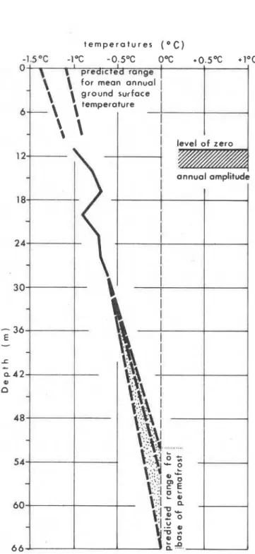
When the indirectly derived geothermal gradients are linearly extrapolated downwards from the observed temperature at the base of the hole, one year after installation of the cable, the 0°C isotherm is encounter- ed within a depth range of 52-65 m (Fig. 12).
Although subject to some potential criticism, the short range of the extrapolation suggests that these values are reasonable for the permafrost base, although some error may be introduced by temperature distur- bance due to climatic change or by variations in thermal conductivity at depth.
Considering the effects of climatic change first, it proved fruitful to examine the data on air temperatures and snowfall from the nearby climatic station at Mur- dochville* (Fig. 13). This data shows no evidence of a cumulative shift in air temDeratures or snowfall values and, by implication, in ground surface temperatures over the last 25 years. This is certainly valid evidence in support of the suggested linearity of the temperature gradients for the upper few tens of metres at the Mont Jacques Cartier site. Previously occurring climatic fluc- tuations, discussed later in this paper, may have given
2. This proved to be the most suitable climatic station for the purposes of comparison because of its good records. proximity to Mont Jacques-Cartier and location in the Gaspe Highlands at a similar distance from the coast.
J.T. GRAY and R.J.E. BROWN
FIGURE 12. Extrapolation of geothermal gradients down- wards to the base of the permafrost body and upwards to the ground surface for the Mont Jacques-Cartier site.
Extrepolation des gradients geothermiques vers le bas, jus- qu'au niveau infbrieur du pergblisol, et vers le haut, jusqu'd la surface, au mont Jacques-Cartier.
culate the downward progress of the thermal distur- bance initiated by these climatic fluctuations.
The error potential in using a limited number of thermal conductivity values from the upper 30 m to derive thermal gradients for only slightly greater depths is probably insignificant. The summit of Mont Jacques Cartier is not on the margin of the batholith and the limited variations in rock density and crystalline compo- sition anticipated, do not likely result in large depart- ures from these thermal conductivity values and hence in large departures from a linear geothermal gradient. 3. THICKNESS OF THE PERMAFROST BODY ON
MONT JACQU ES-CARTIER
This parameter is then readily determined by sub- tracting the depth of the active layer from the total depth to the permafrost base. Permafrost thickness on Mont Jacques-Cartier is thus calculated to be in the range of 45-60 m.
SPATIAL EXTENT OF THE MONT
JACQUES-CARTIER PERMAFROST BODY
If we use the adiabatic lapse rate of 0.6"C/100 m in association with the mean annual surface temperature at the summit of Mont Jacques-Cartier to assess the lower limits of the permafrost body on this mountain, a hypothetical altitude of 1000-1100 m. above sea level is obtained. However, this assumes that terrain factors (degree of exposure, surface materials, vegetation cover and snow cover) remain constant. The Mont Jacques- Cartier summit plateau is not very extensive and exhibits considerable topographic contrast around the margins. This fact, coupled with the effect of the altitudinal transition from tundra through krummholz to forest vegetation (Fig. 14), calls for a more sophisticated delineation of the permafrost body.
The surface conditions of the plateau are maintained with considerable uniformity in a long narrow zone extending from NNE to SSW but elevations drop off rapidly towards the ESE, where an important lee situa- tion, favourable to a very deep winter snow cover, exists just below the summit dome.
This zone of heavy snow accumulation favours highel ground temperatures in winter. The aspect and moderate inclination of the slope also favour relatively high ground temperatures in summer (except where the snowbanks are deepest and persist until mid or late summer). Thus, permafrost is probably absent from this significant bulges at greater depths which could in- zone, despite its high altitude.
he-total
absence of troduce slight errors into the extrapolated values for the ground ice right to the base of a 4 m deep pit, excavat- permafrost base. In order to improve the accuracy of ed for soil studies by Payette beneath an alpine meadow these values it may be possible in the near future to on this slope late in August 1978, lends support to use mathematical models of thermal diffusion to cal- this conclusion.PERMAFROST IN THE CHIC-CHOCS MOUNTAINS
FIGURE 13. Temperature and snow fall data for Murdoch- Donnbes de temperature et de precipitations neigeuses 9 ville over the period 1953-1975. This station is situated at Murdochville, de 1953 9 1975. La station mbtborologique est 550 m elevation about 30 km east of Mont Jacques-Cartier. situee B 30 km B I'est du mont Jacques-Cartier, 9 550 m
d'altitude. Below this zone, c o n d i t i ~ n s become even more
unfavourable for permafrost because of the dense krummholz vegetation which traps the snow, giving accumulations in excess of 2 m, even in low snowfall winters such as 1978-1 979.
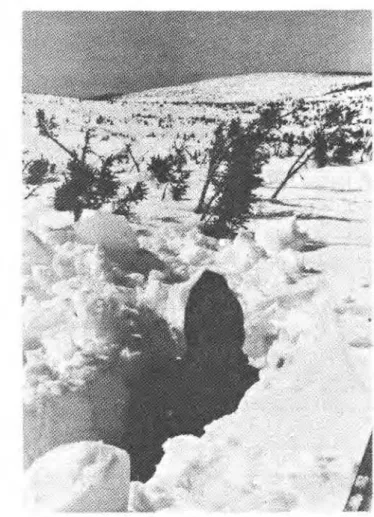
The boundary on the northern, northwestern and southwestern sides of the summit plateau is probably related much more to the rapid increase in thickness of the snow cover associated with the descent below treeline than to any other single factor. Previously cited snow depths in the Lac a Rene area for April 1979 at a mean altitude of 1150 m in the lower krummholz and subalpine forest zones are about 4 times those of the summit plateau. Figures 15 and 16 graphically il- lustrate this contrast. In addition, one winter's data tend to suggest that the snow pack is essentially complete
towards the end of January, thus providing maximum insulation during the coldest period of the winter.
On these slopes the probable permafrost boundary has therefore been traced along a line where the krummholz becomes relatively cantinuous. It is possible however that tiny permafrost islands also exist at lower altitudes on rocky slopes with a northern exposure and with poor vegetative cover due to the low radiative input in the summer and the lack of insulation afforded by a low snow cover in the winter.
Figure 17 is a tentative cross section of the perma- frost body from ENE to WSW across the summit of Mont Jacques-Cartier. The relatively thin nature of the permafrost body suggests that the transition from per- mafrost to no permafrost at the lateral margins should be relatively rapid with minimum lateral heat transfer.
31 0 J.T. GRAY and R.J.E. BROWN
FIGURE 14. Plan view of the summit plateau of Mont Jac- Vue en plan du plateau somm~tal du mont Jacques-Cartier. ques-Cartier.
CONTEMPORANEITY OF THE PERMAFROST ON MONT JACQUES-CARTIER
The available evidence indicates clearly that the permafrost is contemporary and not relict in nature. In the first place the permafrost table is only
5
to 6 m below the surface. If the permafrost body had developed only in response to a colder phase than that prevailing at the present day, (such as during the historically recent "little ice age"), thermal diffusivity of the bedrock would have been sufficiently great for a rapid descent of the permafrost table, far beyond 5-6 m, within only a few decades of the onset of a warming trend.In the second place, the mean annual surface tempe- rature of
1 ° C
to-1.5"C
deduced above for the site, and the mean annual air temperature of-3°C
to5 " C ,
clearly support the conclusion that the present day climate favours contemporary permafrost on the summit plateau.
Of course, this does not deny the fact that a cooler climate in the "little ice age" would have resulted in a thicker, colder permafrost body. In this case the alti- tudinal limit for permafrost would also have been lower, but only where suitably exposed treeless terrain exists.
PERMAFROST IN THE CHIC-CHOCS MOUNTAINS
31 1
FIGURE 16. Snow cover on the summit plateau of Mont Jacques-Cartier in April 1979.
,
Couvert nival au sommet du mont Jacques-Cartier, en avril1979.
Cartier. FIGURE 15. Snow cover in the krummholz zone near Lac
a Rene on north flank of Mont Jacques-Cartier in April 1979. tained from an old well hole on Mont Logan and from
Couvert nival dans la zone de krummholz en avril 1979, pr&s Short drill On Albert enable
du lac
A
Ren6, sur le versant nard du mont ~ a c q u e s - ~ a r t i ~ ~ . predictions to be made of permafrost distribution in the Chic-Chocs Mountains.The Mont Logan site is at an elevation of 1100 m o n a small rocky bench with a north facing slope about
A summary of long term mean 30 m below the summit. Figure 19 shows the tempera-
temperatures for four stations within 250 krn of the ture profiles obtained one week and one year after Chic-Chocs summits does reveal considerable climatic installation of a temperature cable in oil filled tubing variation within the last century (Fig. 18). A major in the well hole. The lowest temperatures at the 32 m warming trend from the late 19th century UP to about level appear to indicate the absence of permafrost 1910 was followed by a marked dip in temperatures at the site. Certain facts suggest, however, that the until about 1930 and then by another warming trend UP ground temperatures may be artificially high. In the to 1950. The latter is in the approximate range of 1.5"C first place the site is 3 of the corner of a to 2 " ~ , and will very likely be shown UP in the sub- heated building used by Radio-Canada as a television profiles, if and when data relay station. This favours a lateral flow of heat through- deeper holes can be acquired for the region. out the year towards the cable site. Using appropriate nomograms for thermal disturbance due to heated
MAPPING
PERMAFR0ST DISTRIBUTION I N
buildings (JUMIKIS, 1977) it is possible to deduce thatTHE CHIC-CHOCS MOUNTAINS
ground temperatures at a depth of 20-30 m have been artificially raised by about 0.5"C to 1°C. In the secondThe previously described data from Mont Jacques- place, snow cleared from the drive-way in front of the Cartier, when coupled with more summary data ob- building is piled above the cable site to a height of
J,T. GRAY and R.J.E. BROWN 4
OC
I
C a p -
C h a t
3 Oc
I
13OC
A n t i c o s t i -
s o u t h W e s t P o i n t2OC
1°C
I o b s e r v a t i o n y e a r sFIGURE 18. Climatic data from 4 stations within 250 km of Donnbes climatiques de quatre stations mbtborologiques si-
the study region. Data is plotted on the basis of 10 year run- tubes B I'int6rieur d'une zone de 250 km autour de la r6g1on
ning means. btudi6. La repr6sentation graphique des donn6es r6sulte de
moyennes mobiles de 10 ans.
several metres each winter and this undoubtedly insu- lates the site from winter heat loss, thereby raising its temperature.
It is thus possible that, prior to recent disturbance by man, the thermal regime of the site may have very closely approached permafrost conditions. Indeed, when the well was drilled in the 1960-1970 period, a pump was lost through being encased in ice at the bottom of the hole, leading to its abandonment. Cou- pled with the fact that the summit of Mont Logan protrudes about 30 m above the krummholz cover, is extremely windswept and characterized by a mean
annual temperature of -3.7"C over the decade 1963- 1973, these arguments suggest that the summit of Mont Logan lies slightly above the regional permafrost limit. This conclusion accords well with the limit of 1000- 1100 m deduced previously from the Mont Jacques- Cartier data for exposed treeless surfaces. It is very likely that permafrost will eventually be restored at the cable site if and when the Radio-Canada building is abandoned.
The Mont Albert data was obtained in September 1979 from four shallow drill holes at an elevation of
PERMAFROST IN THE CHIC-CHOCS MOUNTAINS
t e m p e r a t u r e s ( O C ) summits and is shown in Figure 20. The micro-topog-
o OgC 'l'C '2eC *30C ' 4 0 C '6*C ' 7 g C raptly at the sites varied considerably; profiles 1 and
2
were obtained in drill holes in an exposed rock knob subject to very low winter snow accumulation; profiles
d 3 and 4 from depressions filled with snow in the winter.
This explains why profiles 1 and 2 are from 2°C to 4°C
B cooler than profiles 3 and 4 at a depth of 5 m.
The form of the profiles, particularly profile 1, indi- cates that permafrost is absent at the site. A minimum 12
-
value of 1.0% is attained at a depth of 8.7 m for profileE
-
1, beneath which, temperatures increase to the baser
-
16 of the hole. Permafrost conditions probably prevail
a over large expanses at only slightly higher altitudes
PI
a on the treeless windswept plateau.
Combining information on the treeline gleaned from a series of false colour air photographs, with this newly
24-
i
1
----
3 / 9/
1 9 7 7 established lower permafrost limit of 1000-1100 m fori
exposed surfaces, it has proved possible to map perma- frost distribution for the eastern Chic-Chocs MountainsE
28 k
I
(Fig. 21). The western Chic-Chocs Mountains are notI
I included in this map since only a few summits, notably
I Mont Logan, protrude above either the treeline or the
32 1 regionally established limit. Permafrost in this western
FIGURE 19. Temperature profiles In a 32 m deep disused zone is therefore restricted to very few, small bodies,
well near the summit of Mont Logan. impossible to represent on a map.
Profils therrniques obtenus B partir d'un puits desaffecte prbs 1, ~i~~~~ 21 the permafrost boundary usually corre-
du sommet du mont Logan. sponds to the climatically controlled treeline and not
t e m p e r a t u r e a ( O C )
O'C lo c 2OC 3 *C d'C 5 OC 6 % 7% B'G P'C l0OC
0 2
-
"7:
4-
U E-
, z0
6 0 u-
~ r o ! l l e s f o r w i n d -blown expqsed sitad8
,--
Profiles for snow filled ckprastions10 Dotes o f readings 9 / 9 / 1 9 7 9
FIGURE 20. Temperature profiles for four old dr~ll-holes at Profrls thermrques obtenus B partir de quatre vreux trous de
1lJ00 m In the col between the south and north summits of forage s1tu6s B 1000 m d'altrtude pans le col entre ies som-
-
314 J.T. GRAY and R.J.E. BROWN
PREDICTED PERMAFROST
OCCURRENCE I N THE EASTERN
CHIC -CHOCS MOUNTAINS
GASPESl E
Predicted occurrence of permafrost
I
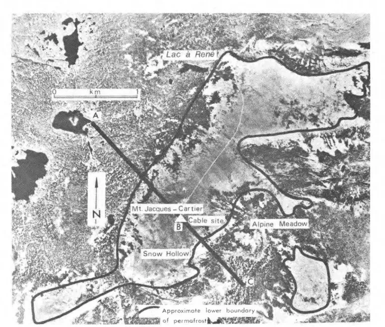
FIGURE 21. Probable distribution of extensive permafrost RBpartition probable des ilots importants d e pergBliso1 dens la bodies in the eastern Chic-Chocs Mountains, Gaspesie. partie orientale des Chic-Chocs, GaspBsie.
to the somewhat lower limit calculated for exposed topography and aspect influence the distribution of per- surfaces. The entrapment of snow by the krummholz mafrost bodies on individual summits due to variations and forest cover reduces heat loss in the winter and in solar radiation received and/or contrasts in snow thereby raises the mean annual temperature above that accumulation. Man's disturbance of the thermal regime, which would be predicted for a treeless surface at that leading to an anomalously positive regime, has already elevation. An exception, of course, is the Mont Albert been indicated for a site at Mont Logan. The case of plateau where as indicated above, the permafrost Mont Notre-Dame in the McGerrigle Mountains could
boundary is within the tundra zone, at 1000-1 100 m. also be mentioned. This summit is at an elevation of
1170 m, is above the local treeline, and should be It must not be assumed from Figure 21 that perma- characterized by permafrost. Limited evidence to date frost is universally present above this limit, nor that it indicates that this may not be the case. The most is totally absent below the limit. Local variations in probable explanation is that the thermal regime has
PERMAFROST IN THE CHIC-CHOCS MOUNTAINS
31
5
been profoundly altered by the mining activities of the Mines d e la Madeleine. Mont NotreDame has been riddled with mining adits and air ducts and is no longer to be considered as a natural situation. Given all of the above considerations, and taking into account the fact that the permafrost bodies are relatively thin, with a thermal regime close to PC, they are bound to be laterally very discontinuous in nature.
Below the regional limit, permafrost islands probably occur in several situations where special terrain factors operate. Such bodies are likely to be only a few metres thick, however, and a few square metres up to a few tens of square metres in extent. Two examples come to mind.
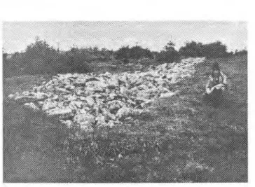
On the steep north facing slopes of glacially carved cirques, mass wasting in the form of rockfalls, avalan- ches, and debris flows have led to the buildup of coarse debris accumulations. In some instances the lobate form of these debris accumulations suggest rock glacier-like flow during the Holocene period (Fig. 22). This implies the presence of ice and hence of perma- frost conditions during at least part of the Holocene period, down to altitudes as low as 800 m. It remains to be determined which, if any, of these forms are active at the present day. But, in any case, a low ground temperature regime is indicated by the shaded nature of the sites, and by the fact that the cold air which penetrates into the interstices between the boulders in winter is probably dislodged with difficulty by the overlying warmer and less dense air layer produced in the early summer. This is the effect described by THOMPSON (1962) as Balch ventilation. Scattered islands of permafrost and ice bodies may well be present. This conclusion would substantiate McGer- rigle's discovery of frost bound talus at an elevation of only 297 m, alluded to at the beginning of this paper (McGERRIGLE, 1952). It is also very interesting in the light of the recent discovery through deep drilling by Hydro-Quebec personnel of a thick zone of buried in- terstitial ice in a rock glacier at 540 m in the Parc des Laurentides, north of Quebec City (GRUMICH and THIBEAULT, 1979).
The second terrain situation, worth investigating for permafrost existence below the regional limit, is in the peat bogs found in extensive depressions on plateau surfaces. If snow accumulation is not excessive on these bogs, then the better insulative properties of fibrous peat in the unfrozen state in the summer, in contrast to its much poorer insulative properties in the frozen state in the winter, may give rise to small thin permafrost bodies. As a word of caution, however, it should be noted that frost mounds - such as palsas or low peat plateaux - usually associated with thin, laterally bounded permafrost in organic terrains, have not been observed to date in the Gaspe Peninsula.
FIGURE 22. Rock glacier like accumulation below the north
facing slope of one of the cirques on the eastern margins
of the McGerrigle massif, approximately 4 km to the north of Mont Jacques-Cartier.
Accumulations semblables A celles des glaciers rocheux sous
le versant expos6 au nord de I'un des cirques, bordure est
des monts McGerrigle, B 4 km au nord du mont Jacques-
Cartier.
CONCLUDING REMARKS
A permafrost body, approximately 60 m thick, under- lies the summit of Mont Jacques-Cartier in the Chic- Chocs Mountains, Gaspesie. Temperature measure ments, heat production and conductivity data, available to a depth of 29 m, indicates that the permafrost is contemporary and that a mean surface temperature of -1°C to -1.5"C can be estimated. The altitude, extent and probable form of the permafrost body on Mont Jacques-Cartier was outlined on the basis of tempera- ture lapse rates and terrain factors. This type of analysis was then applied throughout the region, leading to a map of the treeless summits of the eastern Chic-Chocs which are potentially underlain by permafrost. For such exposed situations, 1000-1100 m appears to be the critical lower limit for extensive permafrost. But spo- radic areas of thin permafrost may exist below the regional limit, in either coarse debris accumulations at shaded sites with a northerly aspect or in organic ter- rain situated in slight depressions on the plateau sur- faces.
Whilst the Chic-Chocs Mountains probably possess the most extensive and thickest bodies of permafrost in the Appalachian region, certain other summits in New England and in Newfoundland protrude above the treeline, and a few of these summits may be underlain by permafrost. In New England, this is definitely the case for Mount Washington, which attains an elevation of 1915 m in the Presidential Range of the White Mountains of New Hampshire. There, the mean annual air temperature is -2.8"C, and below freezing tempera-
J.T. GRAY and R.J.E. BROWN
tures were measured at considerable depths i n a deep well drilled at the summit (HOWE, 1971). M o u n t Katah- din, In Maine, and M o u n t Marcy, in the Adirondack Mountains in New York State, t h e only t w o other mountain areas of New England w h i c h attain elevations i n excess of 1500 m , are, nonetheless, 3 0 0 m below the altitude of M o u n t Washington, and permafrost probably does n o t underlie their summits. In L o n g Range, i n western Newfoundland, initial measurements of g r o u n d temperatures have been obtained by Brookes and B r o w n (pers. comm.) for an 18 m deep drill-hole at an elevation of 550 m. Ground temperatures decreas- ed steadily w i t h depth t o 1.5% at the base of the drill- hole, suggesting that the freezing p o i n t may b e very closely approached at slightly greater depths, and therefore, that the highest summits, at altitudes of almost 800 m, may b e underlain b y permafrost.
ACKNOWLEDGEMENTS
This research was funded by research grants f r o m the Natural Sciences and Engineering Research Council of Canada, by t h e Alma Mater Fund of the Universite d e Montreal a n d by the Ministere d e l ' e d u c a t i o n d u Quebec. Money for the drilling operation o n M o n t Jacques-Cartier was made available f r o m t h e Division of Building Research of the National Research Council i n Ottawa. Thanks are extended t o personnel of the Parc d e l a Gaspesie, i n particular t o MM. Robert Cas- tonguay, Robert Piche and Jacques Bertrand f o r their assistance with the logistical aspects of the research. Finally mention must b e made of t h e assistance i n the field afforded by Guy Bourduas, Bernard Hetu, L o u i s
B. Lafreniere, Jean Poitevin, Bernard Lauriol, Jacques Dupont and Sylvie Lefebvre, all graduate o r under- graduate students i n the Departement d e Geographie, Universite d e Montreal.
REFERENCES
BOUDREAU, F. and PAYETTE, S. (1974): Le mont Jacques- Cartier, Parc de la Gaspesie, De toute urgence, Vol. 5, No. 1. p. 3-18, Quebec.
BROWN, R. J. E. (1966): Influence of vegetation on perma- frost, in Proceedings of 1st lnternational Conference on Permafrost, Nat. Acad. Sci., Nat. Res. Council Pub. 1287, p. 20-25.
-
(1970): Permafrost i n Canada, Toronto Univ. Press, 234 p.DE R ~ M E R , H. S. (1977): Rbgion des Monts McGerrigle, Rap- port geologique no 174, Min. des Richesses naturelles, Que- bec, 233 p.
GAGNON, R. M. (1970): Climat des Chic-Chocs, M. P. 36, Service de la Meteorologie, Min. des Richesses naturelles, Quebec, 103 p.
GRUMICH, J. and THIBEAULT, L. (1979): Projet Lac Louis
-
centrale reserve pompbe: Investigation gbologique 1977-78, Rapport du Service de gbologie et geotechnique, Hydro- Quebec, Montreal.
HOWE. J. (1971): Teniperature readings in test bore holes. Mount Washington Observatory News Bull., Vol. 12, No. 2, p. 37-40.
HYNDMAN, R. D., JESSOP, A. M. and JUDGE, A. S. (1979): Heat flow in the Maritime Provinces of Canada, Can. J. Earth Sci., Vol. 16, No. 6, p. 1154-1165.
IVES, J. D. (1974): Permafrost, in Arctic and Alpine Environ- ments, Ives, J. D. and Barry, R. G. (ed.). Methuen. London, p. 159-1 94.
-
(1979):A
proposed history of permafrost development in Labrador-Ungava, GBogr. phys. Quat., Vol. 33, Nos. 3-4, p. 233-244.JUDGE, A. S. (1973): The prediction of permafrost thickness. Can. Geotech. J., Vol. 10. No. 1. p. 1-11.
JUMIKIS, A. R. (1978): Graphs for disturbance
-
tempera- ture distribution in permafrost under heated rectangular structures, in Proceedings of 3rd lnternational Conference on Permafrost, Nat. Res. Counc., Ottawa, p. 590-596. McGERRIGLE, J. W. (1952): Pleistocene glaciation of GaspePeninsula, Trans. Roy. Soc. Can., Vol. 66, series i l l , p. 37- 51.
PICHElTE. D. R. and PILON. J. A. (1978): Sonde pour profils de temperature des sols du CRDO, Centre de Recherches pour la Dbfense, Ottawa, Note technique no 78-17, 9 p. THOMPSON, W. F. (1962): Preliminary notes on the nature
and distribution of rock glaciers relative to true glaciers and other effects of the climate on the ground in North America, Union gBodBsique et gbophysique internationale, Assoc. intern. d'Hydrologie scientifique, Commission des Neiges et Glaces, Colloque d'obergurgl, p. 212-219.