HAL Id: hal-01218349
https://hal.archives-ouvertes.fr/hal-01218349
Submitted on 2 Dec 2016HAL is a multi-disciplinary open access archive for the deposit and dissemination of sci-entific research documents, whether they are pub-lished or not. The documents may come from teaching and research institutions in France or abroad, or from public or private research centers.
L’archive ouverte pluridisciplinaire HAL, est destinée au dépôt et à la diffusion de documents scientifiques de niveau recherche, publiés ou non, émanant des établissements d’enseignement et de recherche français ou étrangers, des laboratoires publics ou privés.
Coastal Urbanization and Land Planning in Southern
France
Samuel Robert, Aurélie Prévost, Dennis Fox, Marie-Laure Trémélo, Vanina
Pasqualini
To cite this version:
Samuel Robert, Aurélie Prévost, Dennis Fox, Marie-Laure Trémélo, Vanina Pasqualini. Coastal Ur-banization and Land Planning in Southern France. MEDCOAST 15, The Twelfth International Con-ference on the Mediterranean Coastal Environment, Mediterranean Coastal Foundation, Oct 2015, Varna, Bulgaria. pp.119-130. �hal-01218349�
Samuel Robert, Aurélie Prévost, Dennis Fox, Marie-Laure
Trémélo, Vanina Pasqualini
Coastal Urbanization and Land Planning in Southern France.
MEDCOAST 15, The Twelfth International Conference on the
Mediterranean Coastal Environment, Oct 2015, Varna, Bulgaria.
In : Özhan E. (ed.). Proceedings of the Twelfth International
Conference on the Mediteranean Coastal Environment,
MEDCOAST 15, 1-2, pp.119-130, 2015
Coastal Urbanization and Land Planning in Southern
France
Samuel Robert
(1), Aurélie Prévost
(1)(2), Dennis Fox
(1)(3),
Marie-Laure Trémélo
(1)(4), Vanina Pasqualini
(5),
(1) Université Nice Sophia Antipolis, Université Avignon, Aix Marseille Université, CNRS, ESPACE UMR 7300, 13545 Aix-en-Provence, France Tel: + 33-4-42 90 85 32 E-mail: samuel.robert@univ-amu.fr
(2) E-mail: aurelie.prevost@univ-amu.fr (3) E-mail: Dennis.FOX@unice.fr
(4) E-mail: marie-laure.tremelo@univ-amu.fr (5) Université de Corse, 20250 Corte, France E-mail: pasquali@univ-corse.fr
Abstract
Urban sprawl is one of the main pressures affecting coastal areas in the Mediterranean. To assist spatial planning and coastal management policies, the study of urbanization and the characterization of the evolution of built-up areas along the coast are essential prerequisites. In this perspective, the production of land use data sets at a large-scale is necessary. They allow spatio-temporal analysis and, simultaneously, may be used to assess the efficiency of city planning and land planning documents. In France, where the political concern for the protection of the coasts and the limitation of urbanized areas started in the seventies, many tools and planning documents exist and can be put into force at several levels of territorial administration. However, urban sprawl is still a critical issue. It is therefore necessary to analyze how far national policies as well as local spatial planning practices are adapted. Taking as case studies two Mediterranean coastal zones of France (the Côte bleue, close to Marseilles, and the area of the Biguglia Lagoon, next to Bastia in Corsica), this article aims at analysing jointly the evolution of urban areas along with the process of land planning.
Introduction
Coastal urbanization is one of the main environmental challenges today. In many countries of the world, coastal territories are attractive areas, whether to live, to spend holidays or to run a business. Since the 1950’s, this phenomenon has been massive and generalized. Today, it raises serious ecological, economical and social issues. The Mediterranean, cradle of civilizations and major spot of tourism in the world, is particularly affected (Benoit, Comeau, 2005). France is among the countries where coastal urbanization is the oldest and the highest. It is also remarkable for having tried to stem coastal urbanization by environmental policies and by promoting spatial planning and integrated coastal zone management (Deboudt, 2012; Deboudt et al., 2008). Among the emblematic features of the French regulatory framework, the Coastal law (1986) and the Coastal Conservation Authority (1975) are well known beyond national borders. In addition to other provisions, they contribute to a rich legal doctrine to contain urbanization of the territory in general and of the coasts in particular. However, the economic and social growth of French coastal areas continues and the development of the coasts is not frozen. Is there in France a virtuous procedure to reconcile coastal conservation and development of coastal territories? Does the French territorial planning system allow the limitation of urbanization while enabling economic and social development of the territories? Through the study of the recent evolution of two coastal areas on the Mediterranean, the purpose of this article is to reject any simplistic analysis which would suggest that French coasts enjoy adapted policies under the umbrella of the central government which would ensure a balanced development. The detailed analysis of the relationship between land use and spatial planning reveals that, locally, from one place to another, situations can be very different.
Urban sprawl in the coastal zone: a critical issue in France
The extent of urban areas in the French coastal zone is relatively high compared to other European countries. According to the European Environment Agency and the CORINE Land Cover (CLC) database, artificial surfaces within the 0-1 km coastal strip exceed 23 % in 2000, slightly less than Italy (EEA, 2006). Given the length of the French coastline (excluding overseas territories), this figure is particularly high. Only Belgium and Slovenia have higher values. In 2006, artificial surfaces correspond to 28.2% of the areas within the 500 m coastal strip (ONML, 2009). In detail, the urbanized character of the coasts remains very uneven from one region to another. The highest figures are in the Mediterranean (31.6%), but they do not reveal how acute the problem can be locally. While in Corsica the percentage of artificial land in the 0-500 m strip is around 18%, it is 40 % in Languedoc-Roussillon region and 45% in Provence-Alpes-Côte d’Azur. The continental coasts are therefore particularly affected by urban sprawl. The recent dynamics, assessed with the 2000 and 2006 CLC databases, reflect a relative saturation of the areas close to the shore, while the hinterland gets more populated and urbanized. The high level of urban areas on the French Mediterranean coasts is a well-known fact. It can be explained by the presence of old port cities with industries related to the sea and to the processing of products imported by maritime trade (Marseille, Toulon, Sète, La Ciotat). With the end of the French colonial empire in the early 1960s, they had to host a large number of new inhabitants returning to France, especially from North Africa (+ 1.5 million). Many of them grew significantly, with the
building of "emergency districts" and, later on, with collective housing neighborhoods. Urban areas today result also from the residential and tourist economy. In the nineteenth century already, several cities in Provence and on French Riviera (Nice, Cannes, Menton, Monaco, Hyeres, Saint-Raphaël) are famous tourist resorts during the winter season (Boyer, 2002). In the second half of the twentieth century, summer tourism prevails and real-estate economy starts thriving massively. In Languedoc-Roussillon, coastal resorts are equipped from scratch as part of an ambitious development program: Mission Racine, 1963-1983. In Provence and on the French Riviera, small port cities expand and become renowned tourist resorts (Saint-Tropez, Bandol, Sanary-sur-Mer, Bormes-les-Mimosas, etc.). Slowly, a continuous urban fabric is taking place along the coast, except in Corsica. This eventually worries the government which, at the beginning of the 1970s, orders a report on the state of the entire coastal zone along with an assessment of prospects for the future (Piquard, 1973). Much of the current institutional and regulatory framework for the development and protection of the French coasts originates from this report. Other studies and summaries of that kind (Bouyer, 2004; Le Pape and Ribière 1993; Merckelbagh, 2009) have followed afterwards. They all highlight the far too strong urban pressure. Nevertheless, some progress in legislative and regulatory framework have been achieved in the meantime.
Land management and land planning tools to control urbanization on the coast
To tackle with coastal urbanization, the best way is to prevent land from being urbanized by land acquisition and/or protecting natural areas. Another option lies in the obligation made to manage coastal areas through urban planning. These two solutions have been implemented in France. Following the 1973 report, the Coastal Conservation Authority (Conservatoire du littoral1) was created by law in 1975, July 10th. This public institution was established to acquire land in communes on the shores of the sea, estuaries or lakes over 1000 ha, to prevent them from being urbanized, to keep there a natural character and to allow reception of the public. In 2015, the areas under its property extend over 700 sites accounting for 160 000 ha and 1450 km of coastline. The other emblematic element of the French effort to struggle against coastal urbanization is the Coastal Act of 1986, January 3rd (Loi littoral). In municipalities located on the sea shores and estuaries, it imposes a number of rules regarding the possibilities to urbanize. Three fundamental provisions characterize different areas depending on the distance to the sea and/or existing urbanized areas: close to the shore, outside the already urbanized areas, any building in the 0-100 m strip is banned; in or near existing urban areas, obligation to urbanize in continuity of the urban area or in new hamlets integrated into the environment; finally in "areas close to the shore," limited extension of existing urban areas is allowed. To some extent, this law uses relatively vague terms. This has caused a high number of cases before the courts. However, it allows flexible assessment of facts on the field. It does not impose a dogmatic vision. Many court decisions have then clarified the various possible interpretations of the law. Today, it is generally admitted that the Coastal Act has contained urbanization and still prevents from further degradation of the coasts. However, other provisions of the French system must be mentioned. Indeed, France has got a strong tradition of land planning and land management, which has had obvious effects on coastal areas. In 1967, the Land
planning law (Loi d’orientation foncière) created the first local planning documents, in order to anticipate forthcoming urban development through a zoning map and the associated regulation. The Land use plans (POS), at the commune level, and the Urban planning and development schemes (SDAU), at the supra-municipal level, enabled the preparation of the evolution of territories in agreement with the State services. Later on, France has undertaken an administrative decentralization movement which, from 1983 onward, has given extensive responsibilities to local authorities on issues related to economic and social development, culture, land planning and environmental management. Provinces, for example, have obtained the possibility to classify sensitive natural areas and municipalities have been empowered to grant rights to build. Nevertheless, the central government retains certain prerogatives on all these fields. The law is applicable across the country and local planning documents are always subject to legal control by the State services. Thus in 1983, the State introduced into the Town Planning Code the principle of urbanization in continuity of existing urbanized areas for communes without any local planning document, to prevent urban sprawl. It has been taken over by the Coastal Act in 1986 as well as by the law Solidarity and Urban Renewal (SRU) of 2000, which promotes urban intensification and urban renewal. The SRU law introduces changes in local planning documents, giving them a more forward-looking dimension. The former POS becomes the Local urban plan (PLU) and the former SDAU (renamed SD in 1983) becomes the Territorial cohesion scheme (SCOT). During the 2000s, the main provisions against urban sprawl are confirmed by the Grenelle law (2009) and Alur law (2014) by strengthening urban densification and by asking local authorities to prove that they have made efforts to limit their consumption of space. For more than 40 years, France is therefore engaged into efforts to organize a territorial development as much controlled as possible. As regards coastal areas, these provisions are reinforced by specific tools (Coastal Law, Conservatoire du littoral). However, a wide variety of situations may exist about urban sprawl, both in terms of structure and dynamics. So it may be interesting to compare the evolution of urbanization with the terms of urban planning. The legislative and regulatory frameworks are laid down, but local planning policy can vary considerably from one territory to another.
Methodology
According to the Ministry of Ecology (Coastal observatory, ONML), urbanization on the Mediterranean coast is no more as strong as in previous decades. However, assessing the situation from CLC does not account for the dynamics that may take place locally (Bousquet et al., 2013). At the commune level, it is not truly possible to study the relationship between land use change and local urban planning, because of a lack of consistency between the available data that could be used. Our methodological proposal is to go beyond this impediment and to link the recent urban land use with the history of the local urban planning in two coastal areas.
Study area
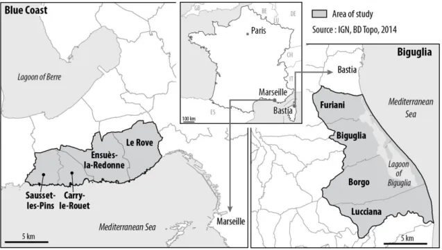
The study was conducted on two distinct territories: the Blue Coast (Côte bleue), west of Marseilles, and the area of Biguglia lagoon, south of Bastia in Corsica (Figure 1). The first site consists of four communes, with a total area of 71 sq. km and a total
population of 24,000 inhabitants in 2011 (INSEE). This is a hilly area, with deep valleys leading to the sea. The coastline is made of steep cliffs and small inlets. Two of the four towns are well established on the coast. The other two are historically located inside the hills and have modest settlements on the seashore. Most of the territory is occupied by natural areas, pine forests and scrubland. The area is included in the Marseilles metropolitan area, between the city of Marseilles itself with its historic harbor in the East, and the Gulf of Fos-sur-Mer and the industrial basins of Marseilles harbor, in the West. Administratively, these four towns are part of the same inter-communal structure: the Marseilles Provence Urban Community. The second site is also comprised of four towns that occupy the north of the eastern plain of Corsica, south of Bastia. These communes have both one part of their territory in the plain (eastward) and another on the mountain (to the west). With 25 000 inhabitants in 2011, they occupy sq. 108 km (INSEE). In the center of the plain is the lagoon of Biguglia, the largest in Corsica, which communicates with the sea by a single channel located at its northern tip. The population is mainly located in the plain, where are located the international airport of Bastia and many industrial and business parks. Though they constitute a coherent territorial entity, these communes are not organized in a single administrative unit at the intercommunal level.
Fig. 1: Study area: two coastal sites on the French Mediterranean
Urban land use mapping on a large scale
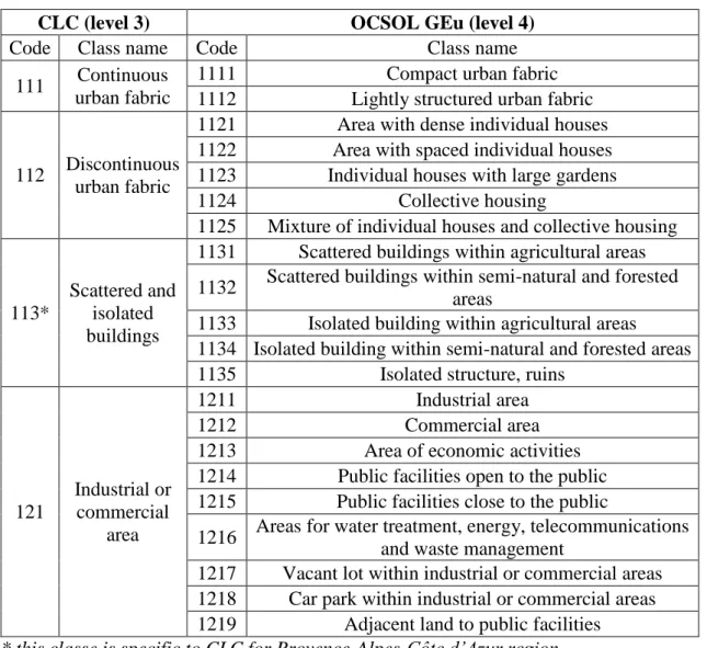
A detailed land use map has been made from the photo-interpretation of aerial photographs. This methodology, called OCSOL Geu, was developed in collaboration with the Regional Geographical Information Centre of the Provence-Alpes-Côte d'Azur region (CRIGe-PACA). It provides a fourth level to the CLC nomenclature for "Artificial surfaces". Based on aerial photographs at 50 cm resolution or better, the building of the database follows a specific protocol indicating the digitizing order of landscape features, the sizes of the minimum mapping units for each object type, the
principles for determining classes, the potential use of external data to assist in photo-interpretation, etc. OCSOL GEu allows the mapping of urbanized areas with 44 land use classes (while CLC level 3 offers 11 classes only) on a scale around of 1:5000 (Table 1). The database may be provided with aggregate classes (levels 1, 2 and 3 of CLC) while offering much greater geometric accuracy. To enable a temporal study, photo-interpretation was completed for several dates: 1998, 2003, 2008 and 2011 for the Blue Coast, and 1990, 2002 and 2011 for the Biguglia area. Produced and integrated into a GIS using ArcGIS, the different versions of the database were analyzed by spatial analysis. A relatively identical period (2002-2011 and 2003-2011) is operable to compare the situation in both study sites.
Table 1: Sample of the OCSOL GEu nomenclature (and correspondence with CLC)
CLC (level 3) OCSOL GEu (level 4)
Code Class name Code Class name 111 Continuous
urban fabric
1111 Compact urban fabric 1112 Lightly structured urban fabric
112 Discontinuous urban fabric
1121 Area with dense individual houses 1122 Area with spaced individual houses 1123 Individual houses with large gardens 1124 Collective housing
1125 Mixture of individual houses and collective housing
113*
Scattered and isolated buildings
1131 Scattered buildings within agricultural areas 1132 Scattered buildings within semi-natural and forested
areas
1133 Isolated building within agricultural areas 1134 Isolated building within semi-natural and forested areas 1135 Isolated structure, ruins
121 Industrial or commercial area 1211 Industrial area 1212 Commercial area 1213 Area of economic activities 1214 Public facilities open to the public 1215 Public facilities close to the public
1216 Areas for water treatment, energy, telecommunications and waste management
1217 Vacant lot within industrial or commercial areas 1218 Car park within industrial or commercial areas 1219 Adjacent land to public facilities
* this classe is specific to CLC for Provence-Alpes-Côte d’Azur region.
Urban planning history and stakeholders interviews
As regards urban planning, investigative work was conducted to reconstruct the history of local planning documents. The crossing of data sources was necessary because it is not easy to trace the paths followed by the municipalities over a period of more than 45 years and because of a fairly wide range of tools that can have been
implemented by the municipalities of the study area. Government databases were searched, as well as the official communes’ websites. A literature review on urban planning issues, land policy and local planning has been done and finally, the State's regional services were also consulted. When they exist, graphic documents of local urban plans (zoning plans) have been collected, digitized and integrated into the GIS. Meanwhile, field visits allowed to meet with local officials and other stakeholders involved in land planning activities to discuss the general dynamics of their respective territories. These semi-structured interviews were used to gather valuable information on the recent history of the eight municipalities studied, on the representations of their leaders about the near future, on their personal feelings and convictions regarding their responsibilities, the coastal law and the difficulties to conduct planning policies in the coastal zone.
Results
Uneven urban planning
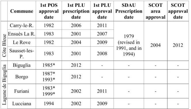
Because planning laws and associated urban planning tools date back to the end of the 1960’s, there are in France several generations of local planning documents. Their adoption by local authorities depends on many economic, social and political factors. Thus, municipalities can be covered by different planning documents (some don’t have any…), both at the local level and the intercommunal one. Therefore, various situations coexists on the territory that demonstrate uneven capacities to design urban planning in line with the law, or even a lack of will to comply with it. The history of urban planning in the study area reveals this type of disparity (Table 2).
Table 2: Dates of local urban planning tools in the study area Commune approval 1st POS
date 1st PLU prescription date 1st PLU approval date SDAU Prescription date SCOT area approval SCOT approval date C ôte B leue Carry-le-R. 1982 2006 2011 Ensuès La R. 1983 2001 2007 1979 (revised in 1991, and in 1994) 2004 2012 Le Rove 1982 2004 2009 Sausset-les-P. 1983 2001 2008 La gune de B igugl ia Biguglia 1985* 2012 - - - - Borgo 1987* 1993* 2012 - - - - Furiani 1983* 1999* 2002 2011 - - - Lucciana 1994 2002 2009 - - -
The Blue Coast is distinguished by the precocity of its planning documents both at municipal level and at the intercommunal one. By the late 1970s, the four towns are covered by the same SDAU and they endow a POS in the early 1980s. Later on, soon after the promulgation of the SRU law, they decide to comply with this law, through the prescription and approval of PLUs and the design of a SCOT with the Marseille Provence Urban Community. In the Biguglia area, spatial planning has been more difficult. First, no planning document of supra-municipal level has ever been drafted and even today the SCOT area is still not yet defined. Second, at the municipal level, initiatives have been taken in the 1980s but unevenly over the territory. In addition, compliance with existing laws appears problematic: in two communes, PLU haven’t been completed yet. In any case, urban planning takes a truly different character between the two areas of study.
Urban sprawl versus contained urbanization
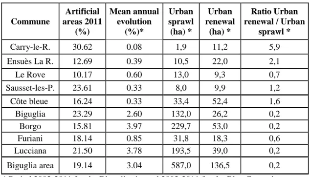
The Biguglia area is slightly more urbanized than the Blue Coast: in 2011, the artificial surfaces account for 19% of the total area (16% on the Blue Coast). However, the picture is more heterogeneous on this second site because artificial surfaces varies between 10.2% and 30.6%, whereas in the Corsican site the variation is between 15.8 and 23.3 (Table 3). About the pace of urbanization, the difference is much more marked. Despite its proximity to Marseilles, the Blue Coast did not record a strong increase in artificial surfaces: the mean annual growth rate between 2003 and 2011 is + 0.33%. Over approximately the same period (2002-2011), the four towns around the Biguglia lagoon increased their artificial areas dramatically (+ 3.04% per year, more than nine times higher).
Table 3: Urban land use dynamics
Commune Artificial areas 2011 (%) Mean annual evolution (%)* Urban sprawl (ha) * Urban renewal (ha) * Ratio Urban renewal / Urban sprawl * Carry-le-R. 30.62 0.08 1,9 11,2 5,9 Ensuès La R. 12.69 0.39 10,5 22,0 2,1 Le Rove 10.17 0.60 13,0 9,3 0,7 Sausset-les-P. 23.61 0.33 8,0 9,9 1,2 Côte bleue 16.24 0.33 33,4 52,4 1,6 Biguglia 23.29 2.60 132,0 26,2 0,2 Borgo 15.81 3.97 229,7 53,0 0,2 Furiani 18.14 0.85 31,8 18,3 0,6 Lucciana 21.50 3.78 193,5 39,0 0,2 Biguglia area 19.14 3.04 587,0 136,5 0,2
* Period 2002-2011 for the Biguglia site and 2003-2011 for the Blue Coast site.
It appears clearly that the period is characterized by strong urban sprawl in the Corsican site and contained urbanization on the Blue Coast. Simultaneously, urban
renewal process (UR), i.e. transition from one artificial surface to another, has been much stronger where urban sprawl has been the lowest. On the Blue Coast, the artificial surfaces resulting from the conversion of areas which were already artificial in 2003 are 1.6 times larger than artificial surfaces resulting from urban sprawl over agricultural or natural areas between 2003 and 2011. The ratio rises up to 5.9 in Carry-le-Rouet, where the share of artificial areas is the highest of the two study sites. In contrast, UR is much lower in the Biguglia area (ratio: 0.2). In Furiani, the town in which this phenomenon is the strongest, it is just over half of the surfaces due to the spread (ratio: 0.6).
In both study sites, UR benefited mainly to residential areas (1121-1124 land use classes). However, this has been very strong on the Blue Coast (over 90% of the new areas resulting from UR) and moderate in the Biguglia area (52%). On the Blue Coast, this is compliant with the profile of the communes, which are dormitory towns of the Marseilles metropolitan area and renowned seaside resorts at the French scale. On the Corsican site, the surfaces resulting from UR are more diverse. They are representative of suburban areas with areas dedicated to habitat as well as to productive and logistic activities (classes 1213, 1211) and transport infrastructures (1221). Facilities for tourism and recreation (1422 class) and construction sites (1331 class) are also fairly well represented. This reflects the strong momentum of transformation of the area.
Spatial pattern of urban sprawl
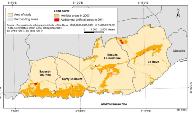
The way urban sprawl has occurred in space is another marker of that the two study sites have evolved in different ways. On the Blue Coast, it seems that urbanization in continuity with pre-existing built-up areas has been the rule. Indeed, the majority of the urban sprawl is located in the periphery of already developed areas in 2003, or in existing vacant places within these areas (Figure 2). Moreover, the areas near the sea have not shown new urbanization.
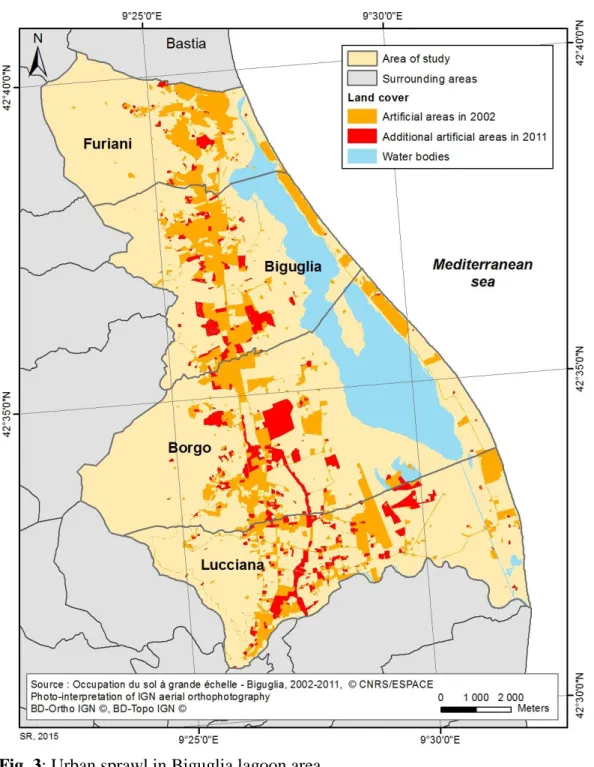
Urban sprawl around Biguglia lagoon presents a more confusing picture (Figure 3). A very significant number of new artificial surfaces have emerged in many places, particularly to the South. While the new urbanized areas appear to be preferentially located along a North-South corridor centered on the highway in Furiani and Biguglia, they are more scattered further South. In Borgo and Lucciana, several new built up areas are scattered over a large perimeter, extending considerably the potential area for future urbanization. Close to the sea, however, urbanization was very low.
Discussion
The two study sites experienced major differences in terms of evolution of the urban areas in recent years. Linking land use mapping on a large scale and history of urban planning offers an appropriate lighting to explain this deviation. On the Blue Coast, where local planning documents have been established earlier and where the planning documents in force are the most up to date, urban sprawl has been the lowest along with a quite important urban renewal. In Biguglia area, on the contrary, urban sprawl has experienced a steady rate, much higher than urban renewal. The principle of urbanization in continuity of existing artificial surfaces has not been respected enough, thereby creating a more complex situation to manage for the future, since the interfaces urban/agriculture and urban/natural have increased.
Still, urban planning can’t explain everything and other parameters must be considered to understand why these municipalities have experienced different trajectories in urbanization. First, it is important to consider the existence of strongly protected natural areas. A fundamental difference between the two sites lies in the fact that, for decades, the Blue Coast has been concerned by vast land acquisitions by the Conservatoire du Littoral. Biguglia is also protected but the areas are much smaller. Secondly, the local and regional geographical context is another factor to consider. Although located near Marseille, the Blue Coast does not represent a particularly favorable space for the city to expand and, above all, it is not the only space for that. The area around Biguglia, on the contrary, offers the only possibility for the city of Bastia to extend. It is a flat and open space on the road to other major cities of Corsica. Third, it would be relevant to incorporate political practices, cultural traits and ways of thinking local development as additional parameters to explain the evolution of the territory. The interviews made with local stakeholders show that the personality of an elected, his personal background and his knowledge of territorial administration, environmental regulations and techniques may vary considerably from one municipality to another.
Conclusion
France is a pioneering Mediterranean country in the struggle against coastal urbanization. Thanks to urban planning rules and environmental legislation, it has tools to contain urban sprawl and to enable the protection of natural areas. However, the political and administrative decentralization initiated in 1983 introduced the possibility for the territories to take charge of town planning and local development. Municipalities and intercommunalities can thus decide their future through local planning documents, which must nevertheless comply with the law that applies to the entire country. This can create a disparity of situations in terms of control of urbanization. The analysis of two suburban coastal areas provides the illustration. For one of them, it seems that the last decade was characterized by efficient space management, a limited urban sprawl and a marked urban renewal, probably in connection with spatial planning developed long ago. For the other, urbanization remains strong, urban renewal is limited and the development of urban planning is more chaotic.
Acknowledgements:
This research has benefited the financial support of the OHM “Littoral méditerranéen” (Labex DRIIHM), through the URBALAG project, as well as the financial support of the Fondation de France (Coastal environment program), through the VIPLI-Med project.
References:
Benoit G. and Comeau A., eds (2005), “A Sustainable Future for the Mediterranean:
The Blue Plan's Environment and Development Outlook”, Routledge, 464 p.
Bouyer C., dir. (2004), “Construire ensemble un développement équilibré du littoral”, DATAR/La Documentation française, Paris, 156 p.
Boyer M. (2002), “L’invention de la Côte d’Azur. L’hiver dans le Midi”, L’Aube, Paris, 378 p.
Bousquet A., Couderchet L., Gassiat A., Hautdidier B., (2013), “Les résolutions des bases de données « occupation du sol » et la mesure du changement. Articuler l’espace, le temps et le thème“, L’Espace géographique, 42, 61-76
Deboudt, P. (2012), “Testing Integrated Coastal Zone Management in France”, Ocean
& Coastal Management, 57, 62‑78.
Deboudt, P., Dauvin, J.-Cl., Lozachmeur, O. (2008), “Recent developments in coastal zone management in France: The transition towards integrated coastal zone management (1973-2007)”, Ocean & Coastal Management. 51, 212-228
EEA. (2006), “The changing faces of Europe's coastal areas”, European Environment Agency. Copenhagen, EEA Report n°6, 107 p.
Le Pape, E. and Ribière, G., (dir.), 1993, “L’aménagement du littoral”, DATAR/La Documentation française, Paris, 112 p.
Merckelbagh A. (2009), “Et si le littoral allait jusqu'à la mer ! La politique du littoral
sous la Ve république, Paris, Quae, 352 p.
ONML (2009), “Indicateur : occupation du sol en 2006 et artificialisation depuis 2000
en fonction de la distance à la mer”, Observatoire national de la mer et du littoral
– UE-SOeS, Corine Land Cover 2000, 2006. URL : http://www.onml.fr/onml_f/Occupation-du-sol-en-2006-et-artificialisation-depuis-2000-en-fonction-de-la-distance-a-la-mer
Piquard, M. (1973), “Le littoral français. Perspectives pour l'aménagement”, La Documentation française, Paris, 266 p.
Keyword :